KR20090058036A - Method and system for displaying graphical objects on a digital map - Google Patents
Method and system for displaying graphical objects on a digital map Download PDFInfo
- Publication number
- KR20090058036A KR20090058036A KR1020097008534A KR20097008534A KR20090058036A KR 20090058036 A KR20090058036 A KR 20090058036A KR 1020097008534 A KR1020097008534 A KR 1020097008534A KR 20097008534 A KR20097008534 A KR 20097008534A KR 20090058036 A KR20090058036 A KR 20090058036A
- Authority
- KR
- South Korea
- Prior art keywords
- digital map
- rendering
- graphic object
- graphical
- coordinates
- Prior art date
Links
Images


Classifications
-
- G—PHYSICS
- G06—COMPUTING; CALCULATING OR COUNTING
- G06T—IMAGE DATA PROCESSING OR GENERATION, IN GENERAL
- G06T15/00—3D [Three Dimensional] image rendering
-
- G—PHYSICS
- G06—COMPUTING; CALCULATING OR COUNTING
- G06T—IMAGE DATA PROCESSING OR GENERATION, IN GENERAL
- G06T17/00—Three dimensional [3D] modelling, e.g. data description of 3D objects
- G06T17/05—Geographic models
-
- G—PHYSICS
- G06—COMPUTING; CALCULATING OR COUNTING
- G06F—ELECTRIC DIGITAL DATA PROCESSING
- G06F16/00—Information retrieval; Database structures therefor; File system structures therefor
- G06F16/20—Information retrieval; Database structures therefor; File system structures therefor of structured data, e.g. relational data
- G06F16/29—Geographical information databases
-
- G—PHYSICS
- G06—COMPUTING; CALCULATING OR COUNTING
- G06F—ELECTRIC DIGITAL DATA PROCESSING
- G06F16/00—Information retrieval; Database structures therefor; File system structures therefor
- G06F16/80—Information retrieval; Database structures therefor; File system structures therefor of semi-structured data, e.g. markup language structured data such as SGML, XML or HTML
- G06F16/84—Mapping; Conversion
Landscapes
- Engineering & Computer Science (AREA)
- Physics & Mathematics (AREA)
- Theoretical Computer Science (AREA)
- General Physics & Mathematics (AREA)
- Databases & Information Systems (AREA)
- Software Systems (AREA)
- Geometry (AREA)
- Remote Sensing (AREA)
- Computer Graphics (AREA)
- Data Mining & Analysis (AREA)
- General Engineering & Computer Science (AREA)
- Processing Or Creating Images (AREA)
- Instructional Devices (AREA)
Abstract
Description
본 발명은 일반적으로 디지털 맵에 관한 것으로, 보다 구체적으로는 디지털 맵 상에 그래픽 객체(graphic objects)를 표시하기 위한 방법 및 시스템에 관한 것 이다.TECHNICAL FIELD The present invention generally relates to digital maps, and more particularly, to a method and system for displaying graphical objects on a digital map.
디지털 맵은 지리적인 위치에 관한 정보를 탐색, 식별 및 발견하기 위해서 발전되어 왔다. 일부 매핑 프로그램(mapping programs)들은 위성 이미지를 사용하여 디지털 맵을 생성한다. 이와 같은 매핑 프로그램들의 예시는 구글 어스(Google Earth) 및 마이크로소프트의 버츄얼 어스(Virtual Earth)를 포함한다. 이와 같은 기존의 매핑 프로그램들은 통상적으로 단순한 그래픽과 맵 형상을 설명하기 위한 주석을 도시하기 위해서 단순한 선들을 사용하여 기본 디지털 맵을 제공한다. 그러나, 기존의 매핑 프로그램은 선천적으로 더 복잡한 2D 및 3D의 그래픽 객체를 지원하지 않는다.Digital maps have been developed to search, identify, and find information about geographical locations. Some mapping programs use satellite images to create digital maps. Examples of such mapping programs include Google Earth and Microsoft's Virtual Earth. Such existing mapping programs typically provide a basic digital map using simple lines to illustrate simple graphics and annotations to describe the map shape. However, existing mapping programs do not natively support more complex 2D and 3D graphical objects.
본 발명의 일실시예에 따르면, 디지털 맵 상에 그래픽 객체를 표시하는 방법은, 그래픽 객체에 대하여, 그래픽 객체의 형식을 나타내는 파라미터, 그래픽 객체의 크기를 나타내는 파라미터, 및 그래픽 객체에 의해서 표현되는 물체의 지리적인 위치를 나타내는 파라미터 그룹을 포함하는 메타데이터를 수신하는 단계를 포함한다. 그래픽 객체의 형식은 저장된 형식의 그룹 중 하나이다. 본 방법은 수신된 메타데이터에 기초한 그래픽 객체에 대한 지리적인 좌표의 생성에 의해서 디지털 맵 상의 그래픽 객체를 렌더링(rendering)하는 단계를 더 포함한다.According to an embodiment of the present invention, a method for displaying a graphic object on a digital map includes, for a graphic object, a parameter indicating the format of the graphic object, a parameter indicating the size of the graphic object, and an object represented by the graphic object. Receiving metadata including a group of parameters indicative of a geographical location of the. The format of a graphic object is one of a group of stored formats. The method further includes rendering the graphical object on the digital map by generating geographic coordinates for the graphical object based on the received metadata.
본 발명의 구체적인 실시예의 기술적인 장점은 그래픽 객체를 기술하는 단순한 메타데이터로부터 마크업 언어 코드(markup language code)를 생성하는 디지털 맵 상에 그래픽 객체를 표시하기 위한 방법 및 시스템을 포함한다. 따라서, 그래픽 객체를 렌더링하기 위한 개발 시간 및 소프트웨어 유지 비용이 극적으로 감소된다.Technical advantages of specific embodiments of the present invention include methods and systems for displaying graphical objects on digital maps that generate markup language code from simple metadata describing the graphical objects. Thus, development time and software maintenance costs for rendering graphical objects are dramatically reduced.
본 발명의 구체적인 실시예의 다른 장점은 신청 메커니즘(subscription mechanism)을 통해서 그래픽 객체 정보를 자동으로 검색하는 디지털 맵 상에 그래픽 객체를 표시하기 위한 방법 및 시스템을 포함한다. 따라서, 본 발명은 극적으로 그래픽 객체를 실시간으로 갱신한다.Another advantage of a specific embodiment of the present invention includes a method and system for displaying a graphical object on a digital map that automatically retrieves the graphical object information through a subscription mechanism. Thus, the present invention dramatically updates the graphic object in real time.
본 발명의 다른 기술적인 장점들은 다음의 도면, 설명 및 청구항으로부터 본 기술분야의 당업자에게 명백해질 것이다. 더 나아가, 특정한 장점들이 상기에 열거되었지만, 다양한 실시예들은 열거된 장점의 전부, 일부를 포함하거나 포함하지 않을 수 있다. Other technical advantages of the present invention will become apparent to those skilled in the art from the following figures, descriptions and claims. Furthermore, while certain advantages are listed above, various embodiments may or may not include all or some of the advantages listed.
본 발명과 이의 태양 및 장점들의 더욱 완전한 이해를 위해서, 첨부된 도면 과 관련된 다음의 설명이 참조적으로 제시된다.For a more complete understanding of the present invention and its aspects and advantages, reference is made to the following description in conjunction with the accompanying drawings.
도 1은 본 발명의 교시에 따르는 디지털 맵 상에 그래픽 객체를 표시하기 위한 시스템을 도시하는 블록도.1 is a block diagram illustrating a system for displaying graphical objects on a digital map in accordance with the teachings of the present invention.
도 2는 본 발명의 실시예와 관련된 디지털 맵 상에 그래픽 객체를 도시하는 대표도.2 is a representative diagram illustrating graphical objects on a digital map in accordance with embodiments of the present invention.
도 3은 디지털 맵 상에 그래픽 객체를 표시하기 위한 방법과 관련된 예시적인 동작을 도시하는 흐름도.3 is a flow diagram illustrating exemplary operations associated with a method for displaying graphical objects on a digital map.
본 발명의 실시예 및 이의 장점은 도 1 내지 도 3을 참조하여 가장 잘 이해될 수 있다. 동일한 숫자는 다양한 도면의 동일한 부분 및 대응하는 부분을 위해서 사용된다.Embodiments of the present invention and their advantages can be best understood with reference to FIGS. Identical numbers are used for the same and corresponding parts of the various figures.
도 1은 본 발명의 교시에 따르는 디지털 맵 상에 그래픽 객체를 표시하기 위한 시스템(10)을 도시하는 블록도이다. 도 1에 도시된 바와 같이, 시스템(10)은 일반적으로 디지털 맵 클라이언트(20), 디지털 맵 서버(30) 및 그래픽 객체 서버(40)를 포함한다. 시스템(10)은 구체적으로 디지털 맵 상에 그래픽 객체를 표시하기 위하여 채용된다.1 is a block diagram illustrating a
디지털 맵 클라이언트(20)는 디지털 맵을 표시할 수 있는 임의의 적합한 기기로 지칭될 수 있다. 디지털 맵은 컴퓨터에 의해서 표시되고 분석될 수 있는 지리적 영역의 임의의 전산화된 표현(computerized representation)으로 지칭될 수 있다. 예를 들어, 디지털 맵 생성의 가장 일반적인 방법은 디지털화이며, 하드카 피 맵은 컴퓨터 프로그램 및 지리적 정보의 사용을 통해서 디지털 매체로 전사(transfer)될 수 있다. 다른 예시에서, 디지털 맵은 아직 맵의 형식은 아니지만 컴퓨터가 인식하고 사용할 수 있는 형식인 기존의 디지털 정보의 전환에 의하여 생성될 수 있다. 따라서, 원거리 감지(remote sensing)를 통해서 생성되는 디지털 위성 이미지는 디지털 정보의 맵-유사 계층(map-like layer)을 생성하기 위해서 결합될 수 있고, 이로 인해 지구의 평면의 평평한 투영(projection)을 만들 수 있다.
본 발명의 구체적인 실시예에서, 디지털 맵 클라이언트(20)는, 사용자가 디지털 맵과 상호작용할 수 있도록 하는 구글 어스와 같은 어플리케이션을 실행할 수 있다. 구글 어스는 위성 이미지로부터 획득한 이미지의 결합에 의해서 지구를 매핑하는(map) 어플리케이션이다. 적절한 명령어의 입력에 의해서, 사용자는 구글 어스에게 상대적으로 낮은 관찰 위치를 위한 "줌"을 지시하여서, 구글 어스가 더 높은 해상도에서 도시되는 더 작은 지리적 영역의 디지털 맵을 표시하도록 할 수 있다. 구글 어스는 또한 사용자에게 디지털 맵 상의 상이한 측면의 위치로 "스크롤" 또는 "플라이(fly)"를 허용할 수 있다. 본 발명의 다른 실시예에서, 디지털 맵 클라이어트(20)는, 사용자가 인터넷을 통하여 디지털 맵과 상호작용할 수 있도록 마이크로 소프트의 인터넷 익스플로러 브라우져(internet Explorer browser)와 같은 다른 어플리케이션을 실행할 수 있다.In a specific embodiment of the invention, the
디지털 맵 클라이언트(20)는 공지된 MS-DOS, PC-DOS, OS-2, MAC-OS, WINDOWS, UNIX 또는 미래의 운영 체제를 포함하는 다른 적당한 운영체제 중 임의의 운영체제에서 실행될 수 있다. 디지털 맵 클라이언트(20)는, 예를 들어 PDA(personal digital assistant), 랩탑과 같은 컴퓨터, 휴대폰, 모바일 핸드셋, 또는 디지털 맵을 표시하도록 동작할 수 있는 임의의 다른 기기를 포함할 수 있다.The
디지털 맵 서버(30)는 참조 번호 31에 의해서 나타난 것과 같이, 디지털 맵, 이미지, 스크립트 언어(scripting languages) 및 디지털 맵 클라이언트(20)로 전송되는 다른 정적인 요소를 전달할 수 있는 임의의 적절한 기기로 지칭될 수 있다.
본 발명의 구체적인 실시예에 따르면, 디지털 맵 서버(30)는 디지털 맵 클라이언트(20)로부터의 요청에 대한 응답으로서 개별적인 디지털 맵 타일들을 전달하도록 동작할 수 있는 타일 제공 시스템(tile serving system)을 용이하게 할 수 있는 소프트웨어를 포함할 수 있다. 예를 들어, 디지털 맵 서버(30)는, 가장 낮은 해상도의 최초의 가장 큰 크기로부터 시작하여 가장 높은 해상도의 최종 크기로 진행하는 다양한 해상도의 매핑 데이터를 제공하기 위하여 연속적인 크기의 계층(hierarchy)으로 매핑 데이터를 구성(organize)할 수 있다. 따라서, 타일 제공 시스템은 상부에서 더 적은 타일을 가질 수 있으며, 각 일련의 감소하는 레벨은 바로 윗 레벨보다 4배 많은 타일을 포함할 수 있다. 본 소프트웨어는 디지털 맵 클라이언트(20)에서 제공되는 대응하는 소프트웨어와 적절하게 인터페이스할 수 있다. 대안적으로, 디지털 맵 서버(30)는 디지털 맵 클라이언트(20)로부터의 요청에 대한 응답으로서 개별적인 맵 타일을 전달할 수 있는 임의의 다른 적합한 소프트웨어를 포함할 수 있다.According to a specific embodiment of the invention, the
그래픽 객체 서버(40)는 디지털 맵 클라이언트(20)에서 디지털 맵 서버 상에 표시하기 위하여 그래픽 객체를 렌더링할 수 있는 임의의 적절한 기기를 나타낸다. 도 1은 디지털 맵 서버(30)로부터 분리되어서 동작하는 그래픽 객체 서버의 일예시를 제공하지만, 다른 실시예에서 그래픽 객체 서버(40)는 디지털 맵 서버(30) 내에서 동작할 수 있다. 또 다른 실시예에서, 디지털 맵 클라이언트(20), 디지털 맵 서버(30) 및 그래픽 객체 서버(40)는 동일한 서버 내에서 동작할 수 있다. 그래픽 객체의 일예시의 추가적인 세부사항은 아래에서 더 상세하게 기술된다.
본 발명의 다양한 실시예에서, 구글 어스와 같은 기존의 매핑 프로그램은 디지털 맵 상에 점 및 선을 표시하기 위한 마크업 언어를 제공할 수 있다. 마크업 언어는 레이아웃, 스타일링(styling) 및 그래픽의 배치를 나타내는 코드를 가지는 언어를 지칭한다. KML(Keyhole Markup Language)은 구글 어스 상에서 지리적 데이터를 관리하기 위한 하나의 마크업 언어이다. KML 문서는 형상의 위도 및 경도 좌표 이외에 기본적인 형상을 기술하는 코드를 포함할 수 있다. 예를 들어, 주도(state capital)의 위치와 같은 위치표지(placemark)는 KML 문서에서 대표 아이콘과 함께 정의될 수 있다. 그러나, 구글 어스와 같은 기존의 매핑 프로그램은 일반적으로 마크업 언어를 사용하여 단순한 선을 표시하는 것으로 제한되고, 선천적으로 더 복잡한 2D 및 3D 그래픽 객체의 표시는 지원하지 않는다.In various embodiments of the present invention, existing mapping programs, such as Google Earth, may provide a markup language for displaying points and lines on a digital map. Markup language refers to a language that has code representing layout, styling, and placement of graphics. Keyhole Markup Language (KML) is a markup language for managing geographic data on Google Earth. KML documents can contain code that describes the basic shape in addition to the latitude and longitude coordinates of the shape. For example, a placemark, such as the location of state capital, can be defined with a representative icon in a KML document. However, existing mapping programs such as Google Earth are generally limited to displaying simple lines using markup languages and do not support the display of inherently more complex 2D and 3D graphic objects.
본 발명의 일실시예에 따르면, 디지털 맵 상에 복잡한 그래픽 객체를 표시하는 시스템 및 방법이 제공된다. 일실시예에서, 이것은 그래픽 객체를 기술하는 단순한 메타데이터로부터 많은 행의 마크업 언어 코드를 생성하기 위한 메커니즘을 제공하는 것에 의해 실행된다. 그 다음에 마크업 언어 코드는 디지털 맵 상에 표시하기 위해서 그래픽 객체를 렌더링하는데 사용된다. 본 발명의 예시적 실시예의 추가적인 세부사항은 도 1, 도 2 및 도 3의 부분과 관련하여 아래에서 더 상세하게 기술된다.According to one embodiment of the present invention, a system and method are provided for displaying complex graphical objects on a digital map. In one embodiment, this is done by providing a mechanism for generating many lines of markup language code from simple metadata describing a graphic object. The markup language code is then used to render the graphic object for display on the digital map. Further details of exemplary embodiments of the invention are described in more detail below in connection with the portions of FIGS. 1, 2 and 3.
본 발명의 예시적인 실시예에 따르면, 그래픽 객체 서버(40)는 MDC(metadata catalog; 42) 및 그래픽 객체 관리자(44)를 포함한다. 예시적인 실시예에서, MDC(42)는 그래픽 객체 서버(40) 내에 상주한다. 그러나, 다른 실시예에서, MDC(42)는 별개의 서버 상에 상주할 수 있다. According to an exemplary embodiment of the present invention, the
MDC(42)는 메타데이터 저장 및 이와 같은 메타데이터의 추가, 수정, 검색을 용이하게 할 수 있도록 하는 임의의 적절한 기기를 지칭한다. 일반적으로, 메타데이터는 다른 데이터를 기술하는 데이터이다. MDC(42)의 맥락에서, MDC(42)는 표시되는 그래픽 객체에 대한 설명적인 데이터로서 메타데이터를 저장한다. 본 발명의 구체적인 실시예에 따르면, MDC(42)는 메타데이터를 저장하기 위해서 관계형 데이터베이스 관리 시스템(relational database management system)을 활용할 수 있으며, 이는 사용하기 쉽고 잘 이해될 수 있는 SQL(Structured Query Languae)과 같은 접속 언어(access language)를 통해서 메타데이터를 사용가능하도록 하며 접속가능하게 한다. 다른 실시예에서, MDC(42)는 다른 메타데이터 관리 시스템을 활용할 수 있다.
일실시예에 따르면, MDC(42)는 디지털 맵 상에 표시되는 그래픽 객체 형식에 대응하는 메타데이터를 자체적으로 저장할 수 있다. 그래픽 객체 형식은 기하학적인 공간에서 묘사되는 기하학적인 객체와 같은, 이미지의 형식으로 컴퓨터 상에 렌더링될 수 있는 임의의 컴퓨터 데이터의 이름을 지칭한다. 예를 들어, MDC(42)는 타원체와 같은, 특정한 위치에 표시되는 3D 그래픽의 형식을 특정하는 형식 값을 저장할 수 있다. 다른 실시예에서, 그래픽 객체 형식은 임의의 디지털 사진, 도표, 아이콘, 기호 또는 이미지의 형식으로 컴퓨터 상에 렌더링될 수 있는 임의의 데이터를 지칭한다. 예를 들어, MDC(42)는 군사적인 기호와 같은, 특정한 위치에 표시되는 아이콘의 형식을 특정하는 형식 값을 저장할 수 있다.According to one embodiment,
본 발명의 일실시예에 따르면, MDC(42)는 자체적으로 디지털 맵 상에 표시되는 그래픽 객체의 지리적 위치에 대응하는 메타데이터를 저장할 수 있다. 예를 들어, MDC(42)는 타원체와 같은 표시되는 3D 그래픽에 대한 중심점을 기술하는 위도, 경도 및 고도 값을 저장할 수 있다. 다른 예시에서, MDC(42)는 군사적 기호와 같은 표시되는 기호에 대한 중심점을 기술하는 위도, 경도 및 고도 값을 저장할 수 있다.According to one embodiment of the invention, the
일실시예에 따르면, MDC(42)는 자체적으로 디지털 맵 상에 표시되는 그래픽 객체의 크기 기술에 대응하는 메타데이터를 저장할 수 있다. 예를 들어, MDC(42)는 타원체와 같은 표시되는 3D 그래픽에 대한 크기를 기술하는 폭, 높이 및 길이 값을 저장할 수 있다. 다른 예시로서, MDC(42)는 원과 같은 표시되는 2D 그래픽에 대한 크기를 기술하는 반지름 값을 저장할 수 있다.According to one embodiment,
테이블 1은, 본 발명의 실시예에 따르는, MDC(42)에 메타데이터로서 저장될 수 있는 그래픽 객체에 대한 속성이 기록된 문서 태그(document tags)가 있는 예시적인 문서이다. 태그는 요소 내에 포함되는 데이터를 나타내는 문서에 내장된 임의의 표식(marker)을 지칭한다. 예를 들어, 테이블 1에서 1행 제1 태그는 문서가 XML(Extensible Markup Language) 문서임을 나타낸다. XML은 데이터를 기술하기 위한 유연한 구문을 지칭한다. DTD(data type definition) 파일들 및 XML 스키마(Schema) 언어 파일들에 기초하여, 관리자 또는 자동화 스크립트와 같은 클라이언트는 XML 태그가 있는 문서를 생성할 수 있다. 자기-설명적인(self-describing) XML 태그는 다양한 그래픽 객체와 관련된 정보와 매핑(map)된다. 그러나, 다른 문서들이 대안적인 실시예에서 동일하게 채용될 수 있다. 예를 들어, 문서는 일부 전용 포맷을 가지는 표준 ASCII 테스트 파일, HTML 파일, 또는 다른 적절한 파일이 될 수 있다.Table 1 is an exemplary document with document tags recorded with attributes for graphical objects that may be stored as metadata in
테이블 1에서, 2행은 그래픽 객체에 대한 중심 점을 기술하는 위도, 경도, 고도 값을 나타낸다. 테이블 1의 3행은 타원체와 같은 그래팩 객체의 형식을 특정하는 형식 값 이외에 타원체의 크기를 기술하는 폭, 높이, 길이 값을 나타낸다. In Table 1, row 2 represents latitude, longitude, and altitude values describing the center point for the graphical object. Row 3 of Table 1 shows the width, height, and length values that describe the size of the ellipsoid, in addition to the format values that specify the format of the graphak object, such as the ellipsoid.
테이블 1: 샘플 문서Table 1: Sample Document

그러나, 본 명세서는 그래픽 객체 속성의 많은 형식을 예상한다. 다양한 실시예는 열거된 속성의 일부, 전부를 포함하거나 또는 전혀 포함하지 않을 수 있다.However, the specification expects many forms of graphical object attributes. Various embodiments may include some, all, or none of the listed attributes.
그래픽 객체 관리자(44)는 컴퓨터-판독가능 매체에 내장된 임의의 적절한 로 직(logic)이고, 이는 실행될 때 디지털 맵 클라이언트(20) 상에 표시하기 위하여 그래픽 객체를 렌더링할 수 있다. 본 발명의 예시적인 실시예에서, 그래픽 객체 관리자(44)는 그래픽 객체 서버(40) 상에 상주한다. 본 발명의 다른 실시예에서, 그래픽 객체 관리자(44)는 디지털 맵 클라이언트(20) 또는 MDC(42)와 연결할 수 있는 임의의 다른 적합한 기기 상에 상주할 수 있다.
본 발명의 예시적인 실시예에 따르면, 그래픽 객체 관리자(44)는 쿼리 모듈(query module; 46), 신청 모듈(subscriber module; 48) 및 렌더링 모듈(50)을 포함하는 다양한 기능을 수행하도록 동작할 수 있는 다양한 모듈을 포함한다.According to an exemplary embodiment of the present invention, the
본 발명의 실시예에 따르면, 쿼리 모듈(46)은 참조 번호 41로 나타난 것과 같이, 메타데이터에 대하여 MDC(42)를 쿼리할 수 있다. 본 발명의 구체적인 실시예에서, 쿼리 모듈(46)은 위치 메타데이터, 그리팩 객체 메타데이터, 상태 메타데이터 또는 임의의 다른 적절한 메타데이터와 같은 메타데이터의 임의의 형식에 대하여 MDC(42)를 쿼리할 수 있다. 쿼리 모듈(46)은 지정된 기준과 일치하는 메타데이터에 대하여 MDC(42)를 쿼리할 수 있다. 예를 들어, 쿼리 모듈(46)에 의해서 사용되는 지정된 기준은 공간적인 기준을 포함할 수 있다. 공간적인 기준은, 그래픽 객체 메타데이터에 대한 검색 필터로서 위도 및 경도 값과 같은 위치 속성을 특정할 수 있다. 다른 예시에서, 쿼리 모듈(46)에 의해서 사용되는 지정된 기준은 문맥상의 기준(contextual criteria)을 포함할 수 있다. 문맥상의 기준은, 그래픽 객체 메타데이터에 대한 검색 필터로서 문자열 패터과 같은 패턴을 특정할 수 있다. 다른 예시에서, 쿼리 모듈(46)에 의해서 사용되는 지정된 기준은 시간적인 기 준을 포함할 수 있다. 시간적인 기준은, 그래픽 객체 메타데이터에 대한 검색 필터로서 최종 수정된 날짜와 같은 시간 속성을 특정할 수 있다. 그러나, 본 명세서는 쿼리 기준의 많은 형식을 예상한다. 다양한 실시예는 열거된 쿼리 기준의 일부, 전부를 포함하거나 또는 전혀 포함하지 않을 수 있다.In accordance with an embodiment of the present invention,
본 발명의 실시예에 따르면, 쿼리 모듈(46)은 JSP(Java Server Pages)를 사용하는 그래픽 객체 메타데이터에 대하여 MDC(42)를 쿼리할 수 있다. JSP는 정의가능한 마크업 언어(definable markup language)를 생성하기 위해서 태크를 활용할 수 있다. JSP 컨테이너(container)에 의해서 실행될 때, 정의가능한 마크업 언어는 XML과 같은 다양한 형식의 결과를 생성할 수 있다. 예를 들어, JSP 컨테이너의 실행 시간 동작(runtime behavior)에 따르면 쿼리 태그의 개구 요소(opening element)가 해석되어서 시스템 메모리에 로딩된다. 태그에서 지정된 임의의 속성은 실행 시간에 로딩될 것이다. 그 다음에, JSP 컨테이너는 모든 중첩된 자식-태그(child-tags)를 해석하고, 그들의 본문의 컨텐츠를 번역하여 부모 쿼리 태그(parent query tag)로 돌려준다. 이러한 점에서, 부모 쿼리 태그는 MDC(42)를 쿼리할 필요가 있는 기준을 가진다.According to an embodiment of the invention,
본 발명의 일실시예에 따르면, 중첩된 태그로부터 쿼리 모듈(46)에 의해서 수집된 검색 기준은 통합되어서 MDC(42)로 전달될 수 있다. 다른 실시예에서, 쿼리 모듈(46)은 검색 기준 없이 MDC(42)를 쿼리할 수 있다. 쿼리 모듈(46)에 의한 MDC(42)로부터의 결과는 수집 객체에 로딩된다. 쿼리 태그에 의해서 생성된 검색 객체의 검색에 의해서, JSP는 실행 시간에 테이블 1의 문서와 같은 개발자-정의 마크업 언어 문서를 생성할 수 있다.According to one embodiment of the invention, the search criteria collected by the
본 발명의 일실시예에 따르면, 신청 모듈(subscriber module; 48)은, 참조 번호 43에 의해서 나타나는 것과 같이 MDC(42)로부터 메타데이터에 대한 연속적인 갱신(continuous updates)을 수신하기 위하여 MDC(42)에 신청할 수 있다. 신청 모듈(48)은 지정된 기준과 일치하는 메타데이터를 위해서 MDC(42)에 신청(subscribe)할 수 있다. 예를 들어, 신청 모듈(48)에 의해서 사용되는 지정된 기준은 상기에 기술된 것 같이 공간적인 기준을 포함한다. 다른 예시에서, 신청 모듈(48)에 의해서 사용되는 지정된 기준은 상기에 기술된 것 같이 문맥적 기준을 포함할 수 있다. 다른 예시에서, 신청 모듈(48)에 의해서 사용되는 지정된 기준은 상기에 기술된 것과 같이 시간적인 기준을 포함할 수 있다. 그러나, 본 명세서는 신청 기준의 많은 형식을 예상한다. 다양한 실시예는 열거된 신청 기준의 전부, 일부를 포함하거나 또는 전혀 포함하지 않을 수 있다.In accordance with an embodiment of the present invention, the
본 발명의 실시예에 따르면, 신청 모듈(48)은 JSP를 사용해서 MDC(42)로부터 메타데이터에 대한 연속적인 갱신을 수신하기 위하여 MDC(42)에 신청할 수 있다. 예를 들어, 디지털 맵 클라이언트(20)에서 사용자 세션은 "subID" 속성 상에 수행될 수 있는 JSP 컨테이너 및 룩업으로부터 검색될 수 있다. "subID" 속성은 사용자 세션 내에 MDC(42) 신청 인스턴스(subscriber instances)를 저장 및 위치시키기 위한 고유 식별자(identifier)로 지칭된다. 인스턴스가 발견되면, 신청 절차가 이어진다. 그렇지 않으면 새로운 인스턴스가 생성된다. 인스턴스는 JSP 컨테이너에 의해서 공급되는 사용자의 세션과 결합된다.In accordance with an embodiment of the present invention,
MDC(42)의 메타데이터에 대한 임의의 갱신에 대하여, 신청 모듈(48)은 각 사용자 세션에 대한 갱신을 수신할 수 있다. 신청 결과는 수집 객체로 로딩된다. 그 다음에 수집 객체는 사용자 세션에 결합된다. 쿼리 태그에 의해서 생성되는 수집 객체의 검색에 의해서, JSP는 실행시간에, 테이블 1의 문서와 같은 개발자-정의 마크업 언어 문서를 생성한다.For any update to the metadata of the
본 발명의 일실시예에 따르면, 렌더링 모듈(50)은 메타데이터를 수신하여 디지털 맵 상에 표시하기 위하여 마크업 언어로 메타데이터를 렌더링한다. 예를 들어, 렌더링 모듈(50)은 수신된 메타데이터로부터 표시되는 그래픽 객체 형식을 식별할 수 있다. 그래픽 객체 형식은, 타원체와 같은 디지털 맵 상에 표시되는 3D 그래픽일 수 있다.According to one embodiment of the invention, the
본 발명의 실시예에 따르면, 렌더링 모듈(50)은 그래픽 객체를 표현하는 모델을 생성하기 위하여 수신된 객체 형식 메타데이터(object type metadata)를 사용할 수 있다. 예를 들어, 렌더링 모듈(50)은 특정한 그래픽 객체 형식에 대한 타원체 모델을 생성할 수 있다. 모델을 생성하기 위하여, 렌더링 모듈(50)은 길이, 폭, 높이와 같은 타원체 속성을 타원체 생성 알고리즘에 입력할 수 있다. 타원체 생성 알고리즘은 직교 좌표(Cartesian coordinates)에서 타원체 모델의 꼭지점의 좌표를 생성할 수 있다. 한정이 아닌 예시로서, 테이블 2는 타원체 생성 알고리즘을 예시한다.According to an embodiment of the present invention, the
테이블 2: 타원체에 대한 샘플 알고리즘Table 2: Sample Algorithms for Ellipsoids

본 발명의 일실시예에 따르면, 렌더링 모듈(50)은 모델의 생성된 좌표에 렌더링 속성을 적용할 수 있다. 예를 들어, 렌더링 모듈(50)에 의해서 적용된 속성은 회전 및 기울기 속성을 포함할 수 있다. 회전 속성은 축을 따라서 모델의 좌표를 회전시키는 속성을 지칭한다. Z-축에 대한 회전을 적용하기 위하여, 렌더링 모듈은 다음의 공식을 사용할 수 있다.According to one embodiment of the invention, the
x = x.coordinatex = x.coordinate
y = (cos(rotation) * y.coordinate) + (sin(rotation) * z.coordinate)y = (cos (rotation) * y.coordinate) + (sin (rotation) * z.coordinate)
z = (-sin(rotation) * y.coordinate) + (cos(rotation) * z.coordinate)z = (-sin (rotation) * y.coordinate) + (cos (rotation) * z.coordinate)
기울기 속성은 북/남 및 동/서 축을 따라서 모델의 좌표를 기울이는 속성을 지칭한다. 동/서 축에 대한 기울기를 적용하기 위하여, 렌더링 모듈(50)은 다음의 공식을 사용할 수 있다.The tilt property refers to the property of tilting the model's coordinates along the north / south and east / west axes. To apply the tilt with respect to the east / west axis, the
x = (cos(tiltE) * x.coordinate) + (-sin(tiltE) * z.coordinate)x = (cos (tiltE) * x.coordinate) + (-sin (tiltE) * z.coordinate)
y = (y.coordinate)y = (y.coordinate)
z = (sin(tiltE) * x.coordinate) + (cos(tiltE) * z.coordinate) z = (sin (tiltE) * x.coordinate) + (cos (tiltE) * z.coordinate)
북/남 축에 대한 기울기를 적용하기 위해서, 렌더링 모듈(50)은 다음의 공식을 사용할 수 있다.To apply the slope for the north / south axis, the
x = (cos(tiltN) * x.coordinate) + (sin(tiltN) * y.coordinate)x = (cos (tiltN) * x.coordinate) + (sin (tiltN) * y.coordinate)
y = (-sin(tiltN) * x.coordinate) + (cos(tiltN) * y.coordinate)y = (-sin (tiltN) * x.coordinate) + (cos (tiltN) * y.coordinate)
z = z.coordinatez = z.coordinate
본 발명의 일실시예에 따르면, 렌더링 모듈(50)은 스케일, 고도 모드, 해상도 및 그림자 속성과 같은, 다른 렌더링 속성을 모델의 생성된 좌표에 적용할 수 있다. 스케일 속성은 모델의 크기를 결정하는 속성으로 지칭될 수 있다. 고도 모드 속성은 지면에 대한 모델의 관계를 결정하는 속성으로 지칭될 수 있다. 해상도 속성은 모델의 직선 세그먼트(line segments)의 수를 결정하는 속성으로 지칭될 수 있다. 그림자 속성은 모델 아래에 대응하는 그림자 요소를 위치시키는 속성으로 지칭될 수 있다. 그러나, 본 명세서는 렌더링 속성의 많은 형식의 표시를 예상한다. 다양한 실시예는 열거된 렌더링 속성의 일부, 전부를 포함하거나 또는 전혀 포함하지 않을 수 있다.According to one embodiment of the invention, the
본 발명의 일실시예에 따르면, 렌더링 모듈(50)은 생성된 모델의 직교 좌표를 극 좌표(polar coordinate) 표현으로 변환할 수 있다. 예를 들어, 메타데이터에서 전달되는 위도, 경도 및 고도 값을 사용하여, 모델의 투영된 위도 및 경도 극 좌표에 대하여 해석하기 위하여 렌더링 모듈(50)에 의해서 다음의 공식이 사용될 수 있다.According to an embodiment of the present invention, the
(latx/longx):(latx / longx):
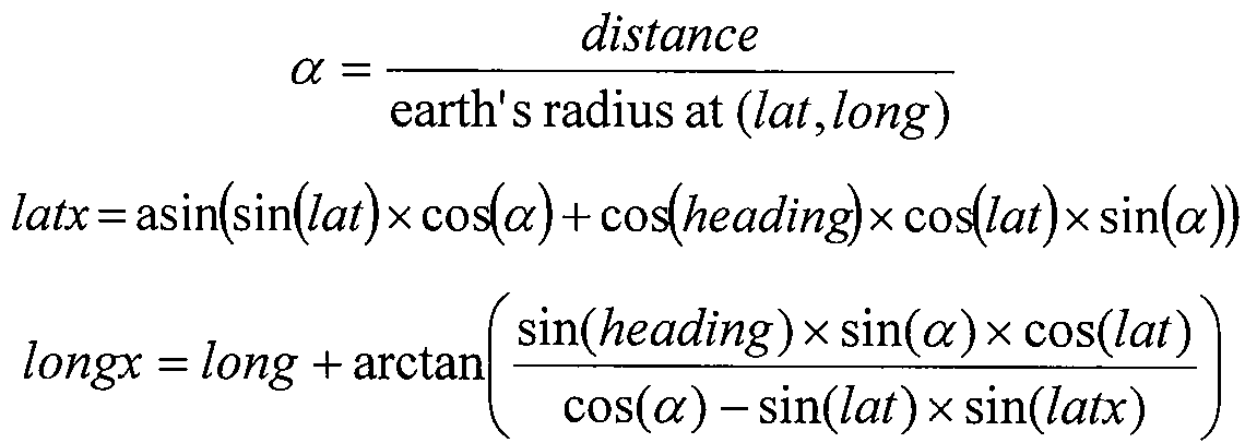
제시된 예시에서, lat 및 long은 모델의 중심점을 표현하고 distance는 모델의 중심으로부터 모델의 점까지의 거리를 표현하고, heading은 북쪽으로부터 시계방향으로 측정된 모델 점의 각도를 나타낸다.In the example shown, lat and long represent the center point of the model, distance represents the distance from the center of the model to the point of the model, and heading represents the angle of the model point measured clockwise from north.
극 좌표 표현을 사용할 때, 렌더링 모듈(50)은 마크업 언어를 사용하여 디지털 맵 상에 좌표를 렌더링하기 위하여 원점 및 모서리로부터 좌표까지의 거리를 사용할 수 있다. 마크업 언어 문서는 모델의 투영된 위도(latx) 및 경도(longx) 좌표에 기초하여 생성될 수 있다. 예를 들어, 일반적인 마크업 언어는 HTML(Hyper Text Markup Language) 및 KML을 포함한다. 예를 들어, KML 문서는, 그래픽 객체의 다양한 선과 좌표를 표현하는 KML 노드(KML nodes)를 사용해서 디지털 지도에 표시하기 위한 그래픽 객체를 특정할 수 있다.When using the polar coordinate representation, the
본 발명의 실시예에 따르면, 테이블 3은 테이블 1의 그래픽 객체를 위하여 렌더링 모듈(50)이 생성할 수 있는 예시적인 KML 문서이다. 테이블 3의 4행 내지 12행 및 14행 내지 22행은 3D타원체의 일부를 구성하는 폴리곤 정보를 나타낸다. 테이블 3의 8행 내지 9행 및 18행 내지 19행은 각각의 폴리곤의 점들의 좌표를 나타낸다. 테이블 3의 13행에서의 생략 부호는 3D 타원체를 렌더링하기 위하여 생성될 수 있는 폴리곤 데이터의 많은 점들을 나타낸다. 따라서, 테이블 1의 적은 선과 태그가 테이블 3의 KML 컨텐츠의 많은 행을 생성할 수 있다.According to an embodiment of the present invention, Table 3 is an exemplary KML document that the
테이블 3: 샘플 KML 문서Table 3: Sample KML Documents

본 발명의 일실시예에 따르면, 참조 번호 23에 의해서 나타나는 것과 같이, 렌더링 모듈(50)은 테이블 3의 샘플 KML 문서와 같은 문서를 표시하기 위하여 디지털 맵 클라이언트(20)로 전달할 수 있다. 예를 들어, 디지털 맵 클라이언트(20)는 참조 번호 21에 의해서 나타나는 것과 같이, 현재 사용자에게 표시되는 특정한 위치에 대해서 그래픽 객체 서버(40)와 통신할 수 있다. 렌더링 모듈(50)은 특정한 위치에서 표시되는 그래픽 객체에 대한 도 1의 문서와 같은 문서를 수신할 수 있다. 렌더링 모듈(50)은 KML과 같은 마크업 언어 문서로 문서를 렌더링할 수 있고, 특정한 위치에서 그래픽 객체를 표시하기 위하여 마크업 언어 문서를 디지털 맵 클라이언트(20)로 전달할 수 있다.According to one embodiment of the invention, as indicated by
도 2는 본 발명의 실시예에 따르는 디지털 맵 상에 그래픽 객체를 도시하는 대표적인 도면(110)이다. 도 2에 도시된 바와 같이, 이미지(110)는 일반적으로 2D 원 객체(12), 3D 구 객체(122), 3D 원뿔 객체(124), 2D 고리 객체(126), 3D 원통 객체(128), 3D 상자 객체(130) 및 3D 반구 객체(132)를 포함한다. 그러나, 본 명세서는 그래픽 객체의 많은 형식의 표시를 예상한다. 다양한 실시예는 열거된 그래픽 객체의 일부, 전부를 포함하거나 또는 전혀 포함하지 않을 수 있다.2 is a representative diagram 110 illustrating graphical objects on a digital map in accordance with an embodiment of the invention. As shown in FIG. 2, the
본 발명의 일실시예에 따르면, 이미지(110)는 2D 및 3D 객체의 와이어 프레임(wire frame) 및 삼각형 매시선(triangular mesh line)을 사용하여 그래픽 객체를 도시하기 위하여, KML과 같은 마크업 언어 문서의 사용에 의해서 생성될 수 있다. 객체를 정의하는 선들의 좌표는 각각의 KML 문서에 저장된 위도, 경도 및 고도 값을 가질 수 있다. 좌표는 그래픽 객체를 형식, 크기 및 위치에 의하여 기술 하는 메타데이터로부터 생성될 수 있다.According to one embodiment of the invention,
이미지(110)는 지정된 위치에 대한 기본 맵 이미지 검색에 의하여 생성될 수 있다. 지정된 위치는 지정된 위치에서의 그래픽 객체에 대한 메타데이터 카탈로그를 쿼리하기 위하여 사용될 수 있다. 그 다음에, 지정된 위치에서의 각 그래픽 객체의 모델은 직교 좌표에 의해서 생성될 수 있다. 직교 좌표는 디지털 맵 상에 투영하기 위하여 극 좌표로 변환될 수 있다. KML 문서와 같은 마크업 언어 문서는, 변환된 좌표에 기초하여 생성될 수 있다. KML 문서는 지정된 위치에서 그래픽 객체를 렌더링하기 위하여 디지털 맵 클라이언트에 의해서 사용된다. 다양한 실시예에 따르면, 그래픽 객체 속성의 적은 선들은 표시되는 그래픽 객체의 복잡도에 따라서 수천 줄의 KML 코드를 생성할 수 있다. 이러한 접근은 유사한 결과물을 생성하기 위한 개발 시간과 소프트웨어 유지 비용을 현저하게 감소시킬 수 있다.
도 3은 디지털 맵 상에 그래픽 객체를 표시하기 위한 방법과 관련된 예시적인 동작을 도시하는 흐름도이다. 예시적인 동작은, 상기에서 도 1을 참조하여 논의된 바와 같이 그래픽 객체 관리자에 의해서 수행될 수 있다. 302 단계에서, 그래픽 객체 메타데이터가 수신될 수 있다. 본 발명의 구체적인 실시예에서, 수신된 메타데이터는 디지털 맵 상에 표시되는 그래픽 객체 형식을 포함할 수 있다. 예를 들어, 메타데이터 카탈로그는 주어진 위치에서 표시되는 타원체를 특정하는 형식 값을 저장할 수 있다. 본 발명의 구체적인 실시예에서, 수신된 메타데이터는 특정한 위치에서 표시되는 그래픽 객체의 지리적 위치를 포함할 수 있다. 예를 들어, 메타데이터 카탈로그는, 타원체와 같은 표시되는 3D 그래픽에 대한 중심점을 기술 하는 위도, 경도 및 고도 값을 저장할 수 있다. 본 발명의 구체적인 실시예에서, 수신된 메타데이터는 디지털 맵 상에 표시되는 그래픽 객체의 크기 설명을 포함할 수 있다. 예를 들어, 메타데이터 카탈로그는, 타원체와 같은 표시되는 3D 그래픽에 대한 크기를 기술하는 폭, 높이 및 길이 값을 저장할 수 있다.3 is a flow diagram illustrating exemplary operations associated with a method for displaying a graphical object on a digital map. Exemplary operations may be performed by a graphical object manager as discussed with reference to FIG. 1 above. In
304 단계에서, 모델은 수신된 메타데이터에 기초해서 생성된다. 그래픽 객체의 형식은 모델을 생성하기 위하여 사용되는 알고리즘을 결정할 수 있다. 예를 들어, 타원체 모델은 특정한 그래픽 객체 형식을 위해서 생성된다. 본 모델을 생성하기 위하여, 메타데이터로부터 길이, 폭 및 높이와 같은 타원체 속성이 타원체 생성 알고리즘에 적용될 수 있다. 타원체 생성 알고리즘은 직교 좌표에서 타원체 모델의 좌표를 생성할 수 있다.At 304, a model is generated based on the received metadata. The format of the graphical object may determine the algorithm used to create the model. For example, an ellipsoid model is created for a particular graphical object type. To generate the model, ellipsoid properties such as length, width and height from metadata can be applied to the ellipsoid generation algorithm. The ellipsoid generating algorithm can generate the coordinates of an ellipsoid model from Cartesian coordinates.
306 단계에서, 모델의 좌표는 디지털 맵 상에 투영되기 위하여 변환된다. 본 발명의 구체적인 실시예에서, 생성된 모델의 직교 좌표는 극 좌표 표현으로 변환될 수 있다. 예를 들어, 메타데이터의 위도, 경도 및 고도 값을 사용하여, 모델의 투영된 위도 및 경도 극 좌표를 해석하기 위하여 변환 공식이 사용될 수 있다.In
308 단계에서, 그래픽 객체는 변환된 좌표를 기초로 하여 렌더링될 수 있다. 예를 들어, 극 좌표 표현에서, 원점 및 모서리로부터 좌표까지의 거리는 디지털 맵 상에 좌표를 투영하기 위하여 사용될 수 있다. 마크업 언어 문서는 투영된 위도(latx) 및 경도(longx) 좌표를 기초로 하여 생성될 수 있다. 예를 들어, 일반적인 마크업 언어는 HTML 및 KML을 포함한다.In
따라서, 그래픽 객체에 대한 크기, 중심 위치 및 종류 메타데이터의 제공에 의해서, 디지털 맵 상에 그래픽 객체를 표시하기 위한 지리적 좌표가 생성될 수 있다. 예를 들어, KML 문서는 다양한 선들과 그래픽 객체를 표현하는 지리적 좌표를 연결시키기 위하여 KML 노드를 사용하여 그래픽 객체를 정의하는데 사용될 수 있다.Thus, by providing size, center position, and type metadata for the graphic object, geographic coordinates for displaying the graphic object on the digital map can be generated. For example, a KML document can be used to define a graphic object using KML nodes to connect various lines and geographic coordinates representing the graphic object.
본 발명이 다양한 실시예에 대하여 기술되었지만, 무수한 교체, 변동, 변경, 변환 및 수정이 본 기술분야의 당업자에게 제시될 수 있으며, 본 발명은 첨부된 청구항의 사상과 범위 이내에서 행해지는 이러한 교체, 변동, 변경, 변환 및 수정을 포함하고자 의도되었다.While the invention has been described with respect to various embodiments, numerous alterations, variations, changes, conversions, and modifications can be made to those skilled in the art, and the invention is not intended to be construed as being made within the spirit and scope of the appended claims, It is intended to include variations, changes, changes and modifications.
Claims (20)
Applications Claiming Priority (2)
| Application Number | Priority Date | Filing Date | Title |
|---|---|---|---|
| US11/534,818 US20080074423A1 (en) | 2006-09-25 | 2006-09-25 | Method and System for Displaying Graphical Objects on a Digital Map |
| US11/534,818 | 2006-09-25 |
Publications (1)
| Publication Number | Publication Date |
|---|---|
| KR20090058036A true KR20090058036A (en) | 2009-06-08 |
Family
ID=39199932
Family Applications (1)
| Application Number | Title | Priority Date | Filing Date |
|---|---|---|---|
| KR1020097008534A KR20090058036A (en) | 2006-09-25 | 2007-09-20 | Method and system for displaying graphical objects on a digital map |
Country Status (7)
| Country | Link |
|---|---|
| US (1) | US20080074423A1 (en) |
| EP (1) | EP2067106A2 (en) |
| JP (1) | JP2010504560A (en) |
| KR (1) | KR20090058036A (en) |
| AU (1) | AU2007300233A1 (en) |
| CA (1) | CA2663049A1 (en) |
| WO (1) | WO2008039679A2 (en) |
Cited By (1)
| Publication number | Priority date | Publication date | Assignee | Title |
|---|---|---|---|---|
| WO2013048843A1 (en) * | 2011-09-26 | 2013-04-04 | Google Inc. | Label positioning technique to reduce crawling during zoom activities |
Families Citing this family (38)
| Publication number | Priority date | Publication date | Assignee | Title |
|---|---|---|---|---|
| WO2007095224A2 (en) | 2006-02-10 | 2007-08-23 | Metacarta, Inc. | Systems and methods for spatial thumbnails and companion maps for media objects |
| JP4360381B2 (en) * | 2006-06-05 | 2009-11-11 | ソニー株式会社 | Information processing apparatus, information processing method, and computer program |
| US9721157B2 (en) | 2006-08-04 | 2017-08-01 | Nokia Technologies Oy | Systems and methods for obtaining and using information from map images |
| WO2009075689A2 (en) * | 2006-12-21 | 2009-06-18 | Metacarta, Inc. | Methods of systems of using geographic meta-metadata in information retrieval and document displays |
| US8468154B2 (en) * | 2007-02-12 | 2013-06-18 | Spinlet Oy | Distribution system for data items |
| US8584013B1 (en) | 2007-03-20 | 2013-11-12 | Google Inc. | Temporal layers for presenting personalization markers on imagery |
| US8558847B2 (en) * | 2009-07-13 | 2013-10-15 | Raytheon Company | Displaying situational information based on geospatial data |
| US20110007134A1 (en) * | 2009-07-13 | 2011-01-13 | Raytheon Company | Synchronizing video images and three dimensional visualization images |
| US20110007150A1 (en) * | 2009-07-13 | 2011-01-13 | Raytheon Company | Extraction of Real World Positional Information from Video |
| US8331611B2 (en) * | 2009-07-13 | 2012-12-11 | Raytheon Company | Overlay information over video |
| US8669983B2 (en) | 2010-08-31 | 2014-03-11 | Microsoft Corporation | Buffer construction with geodetic circular arcs |
| US20120177304A1 (en) * | 2011-01-12 | 2012-07-12 | Raytheon Company | System for image intelligence exploitation and creation |
| US20120188248A1 (en) | 2011-01-26 | 2012-07-26 | The Boeing Company | Image Management and Presentation |
| US9581994B2 (en) | 2011-04-05 | 2017-02-28 | Fisher-Rosemount Systems, Inc. | Methods and apparatus to manage process control resources |
| TWI469102B (en) * | 2011-11-29 | 2015-01-11 | Chun Chia Tai | Method for describing characteristics of drawn objects by a text string |
| US10268761B2 (en) | 2011-12-21 | 2019-04-23 | The Boeing Company | Panoptic visualization document collection |
| US9524342B2 (en) | 2011-12-21 | 2016-12-20 | The Boeing Company | Panoptic visualization document navigation |
| US9104760B2 (en) | 2011-12-21 | 2015-08-11 | The Boeing Company | Panoptic visualization document database management |
| US9495476B2 (en) | 2012-03-23 | 2016-11-15 | The Boeing Company | Panoptic visualization of an illustrated parts catalog |
| US10268662B2 (en) | 2012-09-10 | 2019-04-23 | The Boeing Company | Panoptic visualization of a document according to the structure thereof |
| US10275428B2 (en) | 2012-09-25 | 2019-04-30 | The Boeing Company | Panoptic visualization document differencing |
| US10824680B2 (en) | 2012-10-02 | 2020-11-03 | The Boeing Company | Panoptic visualization document access control |
| US9129429B2 (en) | 2012-10-24 | 2015-09-08 | Exelis, Inc. | Augmented reality on wireless mobile devices |
| US9875220B2 (en) | 2012-11-09 | 2018-01-23 | The Boeing Company | Panoptic visualization document printing |
| FR3000242A1 (en) | 2012-12-21 | 2014-06-27 | France Telecom | METHOD FOR MANAGING A GEOGRAPHIC INFORMATION SYSTEM SUITABLE FOR USE WITH AT LEAST ONE POINTING DEVICE, WITH CREATION OF ASSOCIATIONS BETWEEN DIGITAL OBJECTS |
| FR3000241A1 (en) * | 2012-12-21 | 2014-06-27 | France Telecom | METHOD FOR MANAGING A GEOGRAPHIC INFORMATION SYSTEM ADAPTED TO BE USED WITH AT LEAST ONE POINTING DEVICE, WITH THE CREATION OF PURELY VIRTUAL DIGITAL OBJECTS. |
| US9734625B2 (en) | 2013-01-28 | 2017-08-15 | The Boeing Company | Panoptic visualization of a three-dimensional representation of a complex system |
| US9858245B2 (en) | 2013-01-28 | 2018-01-02 | The Boeing Company | Panoptic visualization of elements of a complex system using a model viewer |
| US9665557B2 (en) | 2013-01-28 | 2017-05-30 | The Boeing Company | Panoptic visualization of elements of a complex system using localization of a point on a physical instance of the complex system |
| US9098593B2 (en) | 2013-04-23 | 2015-08-04 | The Boeing Company | Barcode access to electronic resources for lifecycle tracking of complex system parts |
| US8887993B2 (en) | 2013-04-23 | 2014-11-18 | The Boeing Company | Barcode access to electronic resources for complex system parts |
| US20160306814A1 (en) * | 2013-12-10 | 2016-10-20 | Commodity Flow Limited | Ship location display system |
| US10191997B2 (en) | 2014-08-21 | 2019-01-29 | The Boeing Company | Visualization and diagnostic analysis of interested elements of a complex system |
| US9841870B2 (en) | 2014-08-21 | 2017-12-12 | The Boeing Company | Integrated visualization and analysis of a complex system |
| US9489597B2 (en) | 2014-08-21 | 2016-11-08 | The Boeing Company | Visualization and analysis of a topical element of a complex system |
| US9761204B1 (en) * | 2014-09-30 | 2017-09-12 | Cadence Design Systems, Inc. | System and method for accelerated graphic rendering of design layout having variously sized geometric objects |
| CN109510851B (en) * | 2017-09-15 | 2022-01-04 | 华为技术有限公司 | Map data construction method and device |
| CN109995701B (en) | 2017-12-29 | 2020-12-01 | 华为技术有限公司 | Equipment guiding method, terminal and server |
Family Cites Families (7)
| Publication number | Priority date | Publication date | Assignee | Title |
|---|---|---|---|---|
| JPH1196396A (en) * | 1997-09-19 | 1999-04-09 | Matsushita Electric Ind Co Ltd | Image display device displaying image showing scene in virtual space arranging virtual object |
| JP2004294615A (en) * | 2003-03-26 | 2004-10-21 | Kokusai Kogyo Co Ltd | Map information system |
| CN103398718B (en) * | 2004-03-23 | 2017-04-12 | 咕果公司 | Digital mapping system |
| US7461062B2 (en) * | 2004-12-01 | 2008-12-02 | International Business Machines Corporation | Just-in-time publishing via a publish/subscribe messaging system using a subscribe-event model |
| JP4672383B2 (en) * | 2005-01-28 | 2011-04-20 | 三菱電機株式会社 | 3D map distribution database construction device and 3D map distribution system |
| US7353114B1 (en) * | 2005-06-27 | 2008-04-01 | Google Inc. | Markup language for an interactive geographic information system |
| US8938464B2 (en) * | 2006-04-25 | 2015-01-20 | Google Inc. | Identifying geo-located objects |
-
2006
- 2006-09-25 US US11/534,818 patent/US20080074423A1/en not_active Abandoned
-
2007
- 2007-09-20 EP EP07842838A patent/EP2067106A2/en not_active Withdrawn
- 2007-09-20 CA CA002663049A patent/CA2663049A1/en not_active Abandoned
- 2007-09-20 AU AU2007300233A patent/AU2007300233A1/en not_active Abandoned
- 2007-09-20 WO PCT/US2007/078974 patent/WO2008039679A2/en active Application Filing
- 2007-09-20 KR KR1020097008534A patent/KR20090058036A/en not_active Application Discontinuation
- 2007-09-20 JP JP2009529382A patent/JP2010504560A/en active Pending
Cited By (1)
| Publication number | Priority date | Publication date | Assignee | Title |
|---|---|---|---|---|
| WO2013048843A1 (en) * | 2011-09-26 | 2013-04-04 | Google Inc. | Label positioning technique to reduce crawling during zoom activities |
Also Published As
| Publication number | Publication date |
|---|---|
| US20080074423A1 (en) | 2008-03-27 |
| WO2008039679A3 (en) | 2008-05-29 |
| JP2010504560A (en) | 2010-02-12 |
| EP2067106A2 (en) | 2009-06-10 |
| AU2007300233A1 (en) | 2008-04-03 |
| CA2663049A1 (en) | 2008-04-03 |
| WO2008039679A2 (en) | 2008-04-03 |
Similar Documents
| Publication | Publication Date | Title |
|---|---|---|
| KR20090058036A (en) | Method and system for displaying graphical objects on a digital map | |
| US10990638B2 (en) | Processing ambiguous search requests in a geographic information system | |
| US9542723B2 (en) | Architectures and methods for creating and representing time-dependent imagery | |
| US7353114B1 (en) | Markup language for an interactive geographic information system | |
| US8565514B2 (en) | Markup language for interactive geographic information system | |
| CN105447101B (en) | Map engine implementation method and device | |
| US20150062114A1 (en) | Displaying textual information related to geolocated images | |
| EP2056217A1 (en) | Geographic XML database management system | |
| Paiva et al. | A multiresolution approach for internet gis applications | |
| Hardy et al. | Mobile Mapping On-Demand, Using Active Representation and Generalisation | |
| Hardy et al. | Generalisation, Web Mapping and Data Delivery over the Internet | |
| Denbo | The scientific graphics toolkit | |
| Veregin et al. | Online information dissemination at the Wisconsin State Cartographer’s Office using map services and APIs | |
| de Paiva et al. | Web-Based GIS | |
| van Oosterom et al. | The architecture of the geo-information infrastructure | |
| Chunithipaisan et al. | Geospatial Interoperability via the Web: Supporting Land Administration in Kuala Lumpur | |
| Westin et al. | An OpenGIS web map server for the ESA multi-mission catalogue | |
| Landrum et al. | Software Requirements Specification of National Imagery and Mapping Agency Mapping, Charting and Geodesy Utility Software Environment (NIMAMUSE) Fusion V2. 1. | |
| Senoner | Google Earth and Microsoft Virtual Earth |
Legal Events
| Date | Code | Title | Description |
|---|---|---|---|
| A201 | Request for examination | ||
| E601 | Decision to refuse application |