JP5882753B2 - Positioning information processing apparatus and control method thereof - Google Patents
Positioning information processing apparatus and control method thereof Download PDFInfo
- Publication number
- JP5882753B2 JP5882753B2 JP2012011509A JP2012011509A JP5882753B2 JP 5882753 B2 JP5882753 B2 JP 5882753B2 JP 2012011509 A JP2012011509 A JP 2012011509A JP 2012011509 A JP2012011509 A JP 2012011509A JP 5882753 B2 JP5882753 B2 JP 5882753B2
- Authority
- JP
- Japan
- Prior art keywords
- information
- positioning
- positioning method
- processing apparatus
- information processing
- Prior art date
- Legal status (The legal status is an assumption and is not a legal conclusion. Google has not performed a legal analysis and makes no representation as to the accuracy of the status listed.)
- Expired - Fee Related
Links
Images


Classifications
-
- G—PHYSICS
- G06—COMPUTING; CALCULATING OR COUNTING
- G06F—ELECTRIC DIGITAL DATA PROCESSING
- G06F16/00—Information retrieval; Database structures therefor; File system structures therefor
- G06F16/50—Information retrieval; Database structures therefor; File system structures therefor of still image data
- G06F16/58—Retrieval characterised by using metadata, e.g. metadata not derived from the content or metadata generated manually
-
- G—PHYSICS
- G06—COMPUTING; CALCULATING OR COUNTING
- G06V—IMAGE OR VIDEO RECOGNITION OR UNDERSTANDING
- G06V20/00—Scenes; Scene-specific elements
- G06V20/10—Terrestrial scenes
-
- H—ELECTRICITY
- H04—ELECTRIC COMMUNICATION TECHNIQUE
- H04N—PICTORIAL COMMUNICATION, e.g. TELEVISION
- H04N23/00—Cameras or camera modules comprising electronic image sensors; Control thereof
-
- G—PHYSICS
- G06—COMPUTING; CALCULATING OR COUNTING
- G06F—ELECTRIC DIGITAL DATA PROCESSING
- G06F17/00—Digital computing or data processing equipment or methods, specially adapted for specific functions
- G06F17/40—Data acquisition and logging
Description
本発明は、測位情報処理装置、及びその制御方法に関する。 The present invention relates to a positioning information processing apparatus and a control method thereof.
GPS機能を備えたデジタルカメラや、カメラ機能及びGPS機能を搭載した携帯電話などの普及により、撮影された画像に撮影地点の位置情報を記録する撮像装置が増えてきている。コンピュータにおいては、位置情報を持つ画像を地図上に配置して表示することができる。また、ユーザが画像の位置情報を修正したり、位置情報が記録されていない画像に位置情報を付加したりすることができる。 With the widespread use of digital cameras equipped with a GPS function, mobile phones equipped with a camera function and a GPS function, and the like, an image pickup apparatus that records position information of a shooting point in a photographed image is increasing. In a computer, an image having position information can be arranged and displayed on a map. In addition, the user can correct the position information of the image or add position information to an image in which position information is not recorded.
位置情報を画像ファイルの属性情報として記録する方式の1つとして、Exif規格がある。Exif規格では、位置情報や、それに関連する情報、例えば、測位方式(GPSや無線LANアクセスポイントなど)や測位誤差などを画像ファイルに記録する方法が規定されている。また、記録されている測位誤差に基づき、位置情報を補正する技術も知られている(特許文献1参照)。その一方で、ユーザがパーソナルコンピュータ(PC)などを用いて、画像ファイルに付加された位置情報を任意の位置情報に修正する技術も知られている。 One method for recording position information as attribute information of an image file is the Exif standard. The Exif standard defines a method for recording position information and related information, for example, a positioning method (such as GPS or wireless LAN access point) and a positioning error in an image file. A technique for correcting position information based on a recorded positioning error is also known (see Patent Document 1). On the other hand, a technique is also known in which a user corrects position information added to an image file to arbitrary position information using a personal computer (PC) or the like.
測位方式が記録されている画像ファイルの位置情報をユーザ操作などにより修正した場合、元々記録されていた測位方式をどのように扱うかが問題となる。1つの考え方として、修正後の位置情報はユーザが任意に決定したものであり、元々記録されていた測位方式に従って決定されたものではない、という考え方がある。その一方で、ユーザは修正前の位置情報を知っているので、修正後の位置情報が修正前の位置情報と無関係に決定されたとは限らず、修正後の位置情報も元々記録されていた測位方式から一定の影響を受けていると考えられる場合もある。 When the position information of the image file in which the positioning method is recorded is corrected by a user operation or the like, there is a problem of how to handle the originally recorded positioning method. One way of thinking is that the corrected position information is determined arbitrarily by the user and is not determined according to the positioning method originally recorded. On the other hand, since the user knows the position information before the correction, the position information after the correction is not necessarily determined independently of the position information before the correction, and the position information after the correction was originally recorded. In some cases, it may be considered that there is a certain influence from the method.
しかしながら、画像ファイルに記録されている位置情報をユーザ操作などにより修正した場合に元々記録されていた測位方式を適切に処理する方式は、従来は存在しなかった。この問題は、画像ファイルに記録された位置情報を修正する場合に限らず、位置情報と測位方式とが相互に関連付けられている限り、様々な場合に発生し得る。 However, there has not been a method for appropriately processing the positioning method originally recorded when the position information recorded in the image file is corrected by a user operation or the like. This problem is not limited to correcting the position information recorded in the image file, but may occur in various cases as long as the position information and the positioning method are associated with each other.
本発明はこのような状況に鑑みてなされたものであり、測位方式を示す測位方式情報に関連付けられた位置情報を修正する際に、この測位方式情報を適切に処理する技術を提供することを目的とする。 The present invention has been made in view of such a situation, and provides a technique for appropriately processing the positioning method information when correcting the position information associated with the positioning method information indicating the positioning method. Objective.
上記課題を解決するために、第1の本発明は、衛星を用いる測位方式、無線基地局を用いる測位方式、携帯電話基地局を用いる測位方式のうち、測位に利用された測位方式を示す測位方式情報と、当該測位方式での測位により決定された位置を示す位置情報と、を含む測位情報を取得する取得手段と、前記位置情報が示す位置を変更する変更手段と、前記位置情報が示す位置の変更を指示された場合、前記変更前の位置から前記変更を指示された位置までの距離が所定の閾値以上であるか否かを判定する判定手段と、前記距離が前記所定の閾値以上であると判定された場合に、前記測位方式情報に、前記位置情報が示す位置が手動で設定されたことを示す所定の測位方式を設定する設定手段と、を備えることを特徴とする測位情報処理装置を提供する。 In order to solve the above-mentioned problem, the first aspect of the present invention is a positioning method that indicates a positioning method used for positioning among a positioning method using a satellite, a positioning method using a radio base station, and a positioning method using a mobile phone base station. Acquisition means for acquiring positioning information including method information, position information indicating a position determined by positioning in the positioning method , change means for changing the position indicated by the position information , and the position information When instructed to change the position, determination means for determining whether a distance from the position before the change to the position instructed to change is equal to or greater than a predetermined threshold; and the distance is equal to or greater than the predetermined threshold And positioning means for setting a predetermined positioning method indicating that the position indicated by the position information is manually set in the positioning method information when it is determined that the positioning information is determined. Processing equipment Subjected to.
なお、その他の本発明の特徴は、添付図面及び以下の発明を実施するための形態における記載によって更に明らかになるものである。 Other features of the present invention will become more apparent from the accompanying drawings and the following description of the preferred embodiments.
以上の構成により、本発明によれば、測位方式を示す測位方式情報に関連付けられた位置情報を修正する際に、この測位方式情報を適切に処理することが可能となる。 With the above configuration, according to the present invention, it is possible to appropriately process the positioning method information when correcting the position information associated with the positioning method information indicating the positioning method.
以下、添付図面を参照して、本発明の実施形態を説明する。なお、本発明の技術的範囲は、特許請求の範囲によって確定されるのであって、以下の個別の実施形態によって限定されるわけではない。また、実施形態の中で説明されている特徴の組み合わせすべてが、本発明に必須とは限らない。 Embodiments of the present invention will be described below with reference to the accompanying drawings. The technical scope of the present invention is determined by the claims, and is not limited by the following individual embodiments. In addition, not all combinations of features described in the embodiments are essential to the present invention.
以下の各実施形態では、測位情報処理装置の一例として、画像処理装置について説明する。また、処理対象の測位情報は、画像を撮影した位置を示す位置情報と、この位置の決定に用いた測位方式を示す測位方式情報とを含み、この画像と共に画像ファイルに記録されているものとする。しかしながら、本発明は、画像の撮影位置に関連する測位情報に限らず、位置情報と測位方式とが相互に関連付けられている限り、任意の測位情報に対して適用可能である。 In the following embodiments, an image processing apparatus will be described as an example of a positioning information processing apparatus. In addition, the positioning information to be processed includes position information indicating the position where the image is taken and positioning method information indicating the positioning method used for determining the position, and is recorded in the image file together with the image. To do. However, the present invention is not limited to the positioning information related to the shooting position of the image, but can be applied to arbitrary positioning information as long as the position information and the positioning method are associated with each other.
[第1の実施形態]
図1は、第1の実施形態に係る画像処理装置100の構成を示すブロック図である。画像処理装置100は、表示器101と、操作器102と、CPU103と、一次記憶装置104と、二次記憶装置105と、通信部106と、を備える。
[First Embodiment]
FIG. 1 is a block diagram illustrating a configuration of an
表示器101は、例えば液晶ディスプレイであり、文字や画像などのデータや、メニューなどの所謂グラフィカルユーザインタフェース(GUI)を表示する。操作器102は、ボタンやレバー、タッチパネルなどを含み、ユーザの操作を受け付ける。CPU103は、各種の演算や、画像処理装置100を構成する各ブロックの制御を行う。一次記憶装置104は、一時的なデータを記憶し、CPU103の作業用に使われる。二次記憶装置105は、画像処理装置100を制御するためのオペレーティングシステム(OS)や各種アプリケーションのプログラム、ファイルなどを記憶する。通信部106は、他の装置(例えば、デジタルカメラ)との通信を行い、他の装置から画像ファイルなどの様々なデータを受信する。
The
図2は、画像処理装置100で動作するプログラムによって処理される画像データ及び測位情報を含んだ画像ファイルの一例を示す。本実施形態では、Exif規格に従うファイル形式を採用するものとする。
FIG. 2 shows an example of an image file including image data and positioning information processed by a program operating on the
画像ファイル201は、二次記憶装置105に記録されたファイルとして存在する。画像処理装置100は、例えば通信部106を介して画像ファイル201を取得する。画像処理装置100が画像ファイル201を処理する際には、画像ファイル201は一時的に一次記憶装置104にコピーされることもある。
The
画像ヘッダ部202は、画像データに付帯する情報を保持する。例えば、撮影日時、シャッター速度、絞り値、ISO感度などである。測位情報部203は、画像ヘッダ部202の中に含まれる。測位情報部203は、画像処理装置100が処理する位置情報や測位方式情報などを保持する。画像データ部204は、画像データ本体を保持する。
The
なお、画像ヘッダ部202及び測位情報部203は、必ずしもExif形式に限定されず、例えば画像ファイルとは別のファイルに記録されていてもよいし、画像処理装置100が持つデータベースに記録されていてもよい。
The
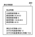
図3は、測位情報部203に保持されている情報の一例を示す。測位情報部203は、地点情報(位置情報)、測位方式情報、及び誤差情報(水平方向誤差情報)を含む。地点情報は、北緯南緯情報、緯度情報、東経西経情報、経度情報、及び高度情報を含む。
FIG. 3 shows an example of information held in the
北緯南緯情報は、緯度情報の値が北緯であるか南緯であるかを示す。緯度情報は、緯度を示す。東経西経情報は、経度情報の値が東経であるか西経であるかを示す。経度情報は、経度を示す。高度情報は、高度を示す。 North latitude / south latitude information indicates whether the value of latitude information is north latitude or south latitude. Latitude information indicates latitude. The east longitude and west longitude information indicates whether the value of longitude information is east longitude or west longitude. The longitude information indicates longitude. The altitude information indicates the altitude.
測位方式情報は、上記の地点情報の決定に用いられた測位方式を示す。本実施形態における測位方式情報は、測位方式として4種類の値をとり得る。 The positioning method information indicates the positioning method used for determining the above point information. The positioning method information in this embodiment can take four types of values as positioning methods.
1つ目の測位方式は、CELLIDである。これは、携帯電話の基地局情報を用いた測位方法である。携帯電話基地局からの現在位置の取得方法としては、次のような方法が存在する。例えば、携帯電話が通信している基地局の位置をそのまま携帯電話の現在位置とする方法や、複数の基地局からの電波の到達時間差と各基地局の設置位置とから現在位置を推定する方法などである。 The first positioning method is CELLID. This is a positioning method using base station information of a mobile phone. There are the following methods for acquiring the current position from the mobile phone base station. For example, the method of using the position of the base station with which the mobile phone is communicating as the current position of the mobile phone as it is, or the method of estimating the current position from the arrival time difference of radio waves from a plurality of base stations and the installation position of each base station Etc.
2つ目の測位方式は、WLANである。これは、無線LANを用いた測位方式である。無線LANからの現在位置の取得は、次のように行う。無線LAN対応のデジタルカメラが単数又は複数の無線LANアクセスポイントからの電波を受信し、それぞれの電波の強度と無線LANアクセスポイントの設置位置とから、現在位置を推定する。 The second positioning method is WLAN. This is a positioning method using a wireless LAN. Acquisition of the current position from the wireless LAN is performed as follows. A wireless LAN compatible digital camera receives radio waves from one or a plurality of wireless LAN access points, and estimates the current position from the intensity of each radio wave and the installation position of the wireless LAN access point.
3つ目の測位方式は、GPSである。これは、GPS受信機が複数の衛星から情報を受信し、自機の現在位置を算出する方法である。 The third positioning method is GPS. This is a method in which a GPS receiver receives information from a plurality of satellites and calculates its current position.
4つ目の測位方式は、MANUALである。MANUALは、ユーザが手動で位置情報を入力したこと(即ち、地点情報が示す位置が手動で設定されたこと)を示す。どのような場合に測位方式情報にMANUALが設定されるかは、デジタルカメラの実装に依存し得る。例えば、ユーザが緯度及び経度を直接入力した場合や、ユーザ操作により地図の特定の箇所が指定されることで緯度及び経度が指定された場合などに測位方式情報にMANUALを設定することが考えられる。従って、測位方式情報にMANUALが設定されている場合、厳密には機械的な測位が行われている訳ではないが、便宜上、MANUALも測位方式の一形態に含めることにする。 The fourth positioning method is MANUAL. MANUAL indicates that the user has manually input the position information (that is, the position indicated by the point information has been manually set). The case where MANUAL is set in the positioning method information may depend on the implementation of the digital camera. For example, it is conceivable that MANUAL is set in the positioning method information when the user directly inputs latitude and longitude, or when latitude and longitude are specified by specifying a specific part of the map by a user operation. . Therefore, when MANUAL is set in the positioning method information, strictly speaking, mechanical positioning is not performed, but for convenience, MANUAL is included in one form of the positioning method.
水平方向誤差情報は、地点情報の水平方向の誤差、即ち緯度情報及び経度情報の誤差を示す。この誤差は、測位時の条件に応じて決定される。例えばGPSの場合、DOP値や、受信したGPS衛星の数と電波強度とから誤差が推定される。 The horizontal direction error information indicates an error in the horizontal direction of the point information, that is, an error in latitude information and longitude information. This error is determined according to the positioning conditions. For example, in the case of GPS, an error is estimated from the DOP value, the number of received GPS satellites, and the radio wave intensity.
なお、図3の例では、北緯35度34分0.3秒、東経139度40分49.5秒、高度30.78m、測位方式情報はGPS、水平方向誤差情報は12mである。 In the example of FIG. 3, the latitude is 35 degrees 34 minutes 0.3 seconds north, the longitude 139 degrees 40 minutes 49.5 seconds, the altitude 30.78 m, the positioning method information is GPS, and the horizontal direction error information is 12 m.
図4は、第1の実施形態に係る画像処理装置100による測位情報編集処理の流れを示すフローチャートである。本フローチャートの処理は、二次記憶装置105に記録されたプログラムをCPU103が読み取って実行することによって行われる。なお、本実施形態では、画像処理装置100は、既にデジタルカメラなどから図2に示す画像ファイルを複数受信して、二次記憶装置105に保存しているものとする。
FIG. 4 is a flowchart showing a flow of positioning information editing processing by the
S401で、CPU103は、二次記憶装置105から画像ファイルを読み出し、一次記憶装置104にコピーする。S402で、CPU103は、読み出した画像ファイルに測位情報部203が存在するか否かを判定する。存在すれば、CPU103は画像ファイルから測位情報を取得し、処理をS403に進める。そうでなければ、処理対象の測位情報が存在しないため、本フローチャートの処理は終了する。
In step S <b> 401, the
S403で、CPU103は、読み出した画像ファイルの画像データを表示器101に表示する。図9にこの表示画面の例を示す。画面左側には、二次記憶装置105から読み出された画像の縮小画像901が一覧表示されている。画面右側には地図(マップ)902が表示される。そして、各画像ファイルの測位情報部203に記録された地点情報に対応する位置にマーク903が重畳表示される。また、このマークをユーザ操作(例えばマウスクリック)により指定すると、対応する画像の縮小画像がポップアップにて表示される。この画面を確認することにより、ユーザはどの位置で画像の撮影が行われたのかを容易に確認することができる。なお、図9に示す画面は一例であり、他の表示形態をとることもできる。例えば、マークの代わりにサムネイルを直接地図上に表示することも可能であるし、例えばファイル名や撮影日時など、他の付帯情報をマーク、或いは縮小画像の近傍に表示してもよい。
In step S <b> 403, the
S404で、CPU103は、画像ファイルの位置情報の編集がユーザによって指示されたか否かを判定する。指示された場合、処理はS405に進み、そうでない場合、本フローチャートの処理は終了する。なお、本実施形態における位置情報の編集は、例えばマウス操作によりマーク903をドラッグし、所望の地図上の位置まで移動させてドロップすることで指示可能である。この場合、本ステップの判定は、マーク903がドラッグ操作されたことを検知することで行われる。なお、ユーザが不注意でマーク903を移動させてしまうのを防止するため、編集モードに移行するためのボタンを図9の画面中に設け、編集モード中のみマークの移動を許可してもよい。この場合、本ステップの判定は、編集モードへの移行を検知することで行ってもよい。
In step S404, the
S405で、ユーザによって、操作器102を介して、画像の新しい位置が入力される。上記の例で言えば、位置の入力操作は、ドラッグ操作されたマークが新たな位置にドロップされる操作に相当する。
In step S <b> 405, a new position of the image is input by the user via the
S406で、CPU103は、地点情報に、S405で入力された新しい位置を示す値を設定する。これにより、S402で取得された地点情報(位置情報)が変更される。
In step S406, the
S407で、CPU103は、測位情報が水平方向誤差情報を含むか否かを判定する。含む場合、処理はS408に進み、含まない場合、処理はS409に進む。
In step S407, the
S408で、CPU103は、測位方式変更境界値(所定の閾値)というパラメータを設定する。測位方式変更境界値は、後述するS412において、測位方式情報を変更するか否かを決定するために使用される。本ステップでは、CPU103は、測位方式変更境界値に水平方向誤差情報の値を設定する。
In S408, the
S409で、CPU103は、測位情報が測位方式情報を含むか否かを判定する。含む場合(即ち、水平方向誤差情報は含まないが測位方式情報は含む場合)、処理はS410に進む。そうでない場合、処理はS411に進む。
In step S409, the
S410で、CPU103は、測位方式変更境界値に、測位方式情報が示す測位方式に応じた値を設定する。ここで設定される値は、S408で利用した水平方向誤差情報の代替となるものである。各種の測位方式(例えばGPS、CELLID、又はWLAN)に応じた平均的な測位誤差の値が予め決められており、その値が測位方式変更境界値に設定される。本実施形態では、GPS、CELLID、WLAN、の順に測位方式変更境界値が大きくなるものとする。これは、各測位方式で予想される平均的な測位誤差の大きさを考慮したものであるが、必ずしもこのような関係になるとは限らない。測位方式情報がMANUALだった場合には、測位方式変更境界値には0が設定される。
In S410, the
S411で、CPU103は、測位方式変更境界値に、所定の値を設定する。ここで設定される値は、S408で利用した水平方向誤差情報、及びS410で利用した測位方式に応じた測位誤差の代替となるものである。具体的な値としては、S410で設定されるいずれの値とも異なる値としてもよいし、いずれかの測位方式に対応する値としてもよいし、各測位方式の平均誤差の平均値としてもよい。
In S411, the
S412で、CPU103は、S402で取得された変更前の位置からS405で入力された変更後の位置までの距離が、所定の閾値以上であるか否か、即ち、測位方式変更境界値以上であるか否かを判定する。測位方式変更境界値以上であれば、処理はS413に進み、そうでなければ、処理はS413を飛ばしてS414に進む。
In S <b> 412, the
図10を参照して、S412における判定の意味について説明する。図10において、マーク1001は、変更前の地点情報の位置を示す。円1004は、マーク1001を中心とし、半径を測位方式変更境界値とする円である。従って、円1004の内側はマーク1001(変更前の位置)からの距離が測位方式変更境界値未満であり、円1004上及びその外側は、マーク1001からの距離が測位方式変更境界値以上である。測位情報が水平方向誤差情報を含む場合、円1004が水平方向誤差を示す誤差円となる。
The meaning of the determination in S412 will be described with reference to FIG. In FIG. 10, a
マーク1002は、変更後の位置の一例を示す。マーク1002の場合、変更前の位置からの距離は測位方式変更境界値未満である。従って、処理はS412からS414へと進む。マーク1003は、変更後の位置の他の例を示す。マーク1003の場合、変更前の位置からの距離は測位方式変更境界値以上である。従って、処理はS412からS413へと進む。
A
変更前後の位置間の距離が測位方式変更境界値以上の場合(即ち、変更後の位置が円1004上又はその外側にある場合)、ユーザが何らかの意図を持って、実際の撮影位置とは別の位置を指定したものと考えられる。この場合、変更前の位置はもはや意味を持たず、従って、変更前の位置に関連する測位方式ももはや意味を持たない。 When the distance between the positions before and after the change is equal to or greater than the positioning method change boundary value (that is, when the position after the change is on or outside the circle 1004), the user has some intention and is different from the actual shooting position. It is thought that the position of was specified. In this case, the position before the change is no longer meaningful, and therefore the positioning method related to the position before the change is no longer meaningful.
従って、S413で、CPU103は、測位方式情報に、当初の値(例えばGPS)に代えて、地点情報が示す位置が手動で設定されたことを示す測位方式であるMANUALを設定する。
Accordingly, in S413, the
他方、変更前後の位置の距離が測位方式変更境界値未満の場合(即ち、変更後の位置が円1004の内側にある場合)、ユーザが元々の位置をある程度信頼しつつも、誤差を微修正したものと考えられる。この場合、変更後の位置も、変更前の位置に関連する測位方式にある程度基づいていると見なすことができる。従って、S413の処理はスキップされ、測位方式情報の変更は行わない。例えば、元々の測位方式情報がGPSであれば、GPSで測位したという事実を修正する意図をユーザが持つ訳ではないと考えられるので、位置変更後の測位方式情報もGPSのまま維持される。 On the other hand, when the distance between the positions before and after the change is less than the positioning method change boundary value (that is, when the position after the change is inside the circle 1004), the error is finely corrected while the user trusts the original position to some extent. It is thought that. In this case, the position after the change can be regarded as being based to some extent on the positioning method related to the position before the change. Therefore, the process of S413 is skipped and the positioning method information is not changed. For example, if the original positioning method information is GPS, it is considered that the user does not have an intention to correct the fact that the positioning is performed by GPS. Therefore, the positioning method information after the position change is also maintained as GPS.
S414で、CPU103は、水平方向誤差情報を削除する。これは、ユーザによって新しい位置が指定されたので、画像ファイルに元々記録されていた水平方向誤差情報は意味がなくなるからである。或いは、水平方向誤差情報を削除する代わりに、CPU103は、水平方向誤差情報に0を設定したり、図6に示すように測位情報部203に水平方向誤差無効化情報を追加したりしてもよい。水平方向誤差無効化情報は、測位情報部203に含まれる水平方向誤差情報が無効であることを示す情報(無効情報)である。CPU103は、S407における判定の際に、水平方向誤差情報に0が設定されている場合、及び水平方向誤差無効化情報が存在する場合には、測位情報が水平方向誤差情報を含まないものと判断する。
In S414, the
なお、測位情報部203は、「水平方向誤差無効化情報=NO」という水平方向誤差無効化情報を元々含んでいてもよい。「水平方向誤差無効化情報=NO」の場合、水平方向誤差情報は有効である(即ち、水平方向誤差無効化情報が含まれない場合と同じである)。この場合、S414で、CPU103は、水平方向誤差無効化情報の値を変更して「水平方向誤差無効化情報=YES」のようにする。
Note that the
S415で、CPU103は、変更後の測位情報を含む画像ファイルを二次記憶装置105に保存する。
In step S <b> 415, the
以上説明したように、本実施形態によれば、画像処理装置100は、変更前後の位置間の距離が所定の閾値以上であるか否かに応じて、測位方式情報を変更するか否かを決定する。これにより、測位方式を示す測位方式情報に関連付けられた位置情報を修正する際に、この測位方式情報を適切に処理することが可能となる。
As described above, according to the present embodiment, the
[第2の実施形態]
第1の実施形態では、測位方式情報が1つの測位方式のみを示すことを前提として説明を行った。これに対して第2の実施形態では、測位方式情報が順位付けされた複数の測位方式を含むことが可能であるものとする。但し、第2の実施形態においても、測位方式情報が1つの測位方式しか含んでいない場合もある。本実施形態において、画像処理装置100の基本的な構成は第1の実施形態と同様である(図1参照)。
[Second Embodiment]
The first embodiment has been described on the assumption that the positioning method information indicates only one positioning method. In contrast, in the second embodiment, it is possible to include a plurality of positioning methods in which positioning method information is ranked. However, also in the second embodiment, the positioning method information may include only one positioning method. In the present embodiment, the basic configuration of the
まず、第2の実施形態に係る測位方式情報について説明する。近年のカメラ付きの携帯電話などは、複数の測位方式を組み合わせてより精度の高い地点情報を得る、所謂ハイブリッド型の測位を行うものもある。本実施形態では、このような場合には、利用した測位方式が全て測位方式情報に含まれるものとする。例えば、GPSと携帯基地局の情報とに基づいて測位が行われた場合、測位方式情報は「GPS CELLID」となるものとする。なお、本実施形態では、測位方式情報に含まれる複数の測位方式は、地点情報の決定の際に寄与の大きな測位方式の順に記述されるものとする。寄与の大きさは、例えばそれぞれの測位における誤差の少なさと予め定められた測位方式そのものの信頼性とに基づき算出される。前述の「GPS CELLID」の例では、GPSによる測位方式の方が、携帯電話の基地局を用いた測位方式よりも寄与が大きいことを示す。 First, positioning method information according to the second embodiment will be described. Some mobile phones with cameras in recent years perform so-called hybrid positioning in which a plurality of positioning methods are combined to obtain more accurate point information. In this embodiment, in such a case, it is assumed that the used positioning methods are all included in the positioning method information. For example, when positioning is performed based on GPS and mobile base station information, the positioning method information is “GPS CELLID”. In the present embodiment, the plurality of positioning methods included in the positioning method information are described in the order of the positioning methods having the largest contribution when determining the point information. The magnitude of the contribution is calculated based on, for example, a small error in each positioning and the reliability of a predetermined positioning method itself. The example of “GPS CELLID” described above indicates that the positioning method using GPS has a larger contribution than the positioning method using a mobile phone base station.
図5は、第2の実施形態に係る画像処理装置100による測位情報編集処理の流れを示すフローチャートである。本フローチャートの処理は、二次記憶装置105に記録されたプログラムをCPU103が読み取って実行することによって行われる。図5において、S407以前の処理、及びS514以降の処理は、第1の実施形態(図4のS401乃至S406、及びS414乃至S415)と同様であるため、図示を省略する。また、S407乃至S409及びS411は図示されているが、これらのステップにおける処理も第1の実施形態(図4のS407乃至S409及びS411)と同様である。
FIG. 5 is a flowchart showing the flow of positioning information editing processing by the
S510で、CPU103は、図4のS410と同様、測位方式変更境界値に、測位方式情報が示す測位方式に応じた値を設定する。測位方式情報が1つの測位方式しか含まない場合、本ステップでの処理は図4のS410における処理と同じになる。他方、測位方式情報が複数の測位方式を含む場合、CPU103は、最も寄与度の高い(即ち、最高の順位の)測位方式のみに基づいて測位方式変更境界値を設定する。或いは、CPU103は、複数の測位方式のそれぞれの寄与度を勘案して算出した値を測位方式変更境界値に設定してもよい。また、測位方式の1つとしてMANUALが含まれる場合は、MANUALそのものは0に変換されるものとして考える。
In S510, the
S512で、CPU103は、S402で取得された変更前の位置からS405で入力された変更後の位置までの距離が、所定の閾値以上であるか否か、即ち、測位方式変更境界値以上であるか否かを判定する。測位方式変更境界値以上であれば、処理はS513に進み、そうでなければ、処理はS514に進む。
In S512, the
S512からS513に進んだ場合、変更後の位置の決定に関して、手動での設定の寄与度が最も大きいと考えられる。従って、S513で、CPU103は、測位方式情報の先頭にMANUALを追加する(即ち、測位方式情報に、MANUALを最高の順位で追加する)。S513の処理は、MANUALの追加後であっても元の測位方式が2番目以降に残っている点で、第1の実施形態(図4のS413)と異なる。
When the process proceeds from S512 to S513, it is considered that the contribution of manual setting is the largest in determining the position after the change. Accordingly, in S513, the
S512からS514に進んだ場合、変更後の位置の決定に関して、手動での設定の寄与度が比較的小さいと考えられる。従って、S514で、CPU103は、測位方式情報の末尾にMANUALを追加する(即ち、測位方式情報に、MANUALを最低の順位で追加する)。S514の処理は、最低の順位とはいえ測位方式情報にMANUALが含まれるという点で、第1の実施形態(図4においてS413がスキップされる構成)と異なる。
When the process proceeds from S512 to S514, it is considered that the contribution of manual setting is relatively small with respect to the determination of the position after change. Therefore, in S514, the
以上説明したように、本実施形態によれば、画像処理装置100は、変更前後の位置間の距離が所定の閾値以上であるか否かに応じて、測位方式情報に、最高又は最低の順位でMANUALを追加する。これにより、測位方式を示す測位方式情報に関連付けられた位置情報を修正する際に、この測位方式情報を適切に処理することが可能となる。
As described above, according to the present embodiment, the
[第3の実施形態]
第3の実施形態では、測位情報部203が図7に示すように構成されており、この点が第1の実施形態(図3参照)と異なる。本実施形態において、画像処理装置100の基本的な構成は第1の実施形態と同様である(図1参照)。
[Third Embodiment]
In the third embodiment, the
図7に示すように、測位情報部203は、編集用測位情報部、及び初期測位情報部を含む。初期測位情報部は、編集用測位情報部の初期値(変更前の値)を示す。換言すると、初期測位情報部は、画像の撮影時に記録された測位情報の内容を保持し続ける。画像処理装置100による測位情報部203の編集は、編集用測位情報部に対して行われ、初期測位情報部の内容は変化しない。編集用測位情報部の初期値は、初期測位情報部と同じである。或いは、最初は編集用測位情報部が存在せず、測位情報部203の編集が行われた時点で編集用測位情報部が生成されてもよい。
As shown in FIG. 7, the
編集用測位情報部は、第1の実施形態と同様(図3参照)、地点情報及び測位方式情報を含む。編集用測位情報部はまた、地点情報の変更前は、初期測位情報部に含まれるものと同じ水平方向誤差情報を含んでもよい。 The editing positioning information section includes point information and positioning method information as in the first embodiment (see FIG. 3). The editing positioning information section may also include the same horizontal error information as that included in the initial positioning information section before the point information is changed.
初期測位情報部は、地点情報の初期値を示す初期地点情報(初期位置情報)と、測位方式情報の初期値を示す初期測位方式情報と、を含む。初期測位情報部はまた、初期地点情報に関する誤差を示す水平方向誤差情報を含んでもよい。 The initial positioning information section includes initial point information (initial position information) indicating an initial value of the point information and initial positioning method information indicating an initial value of the positioning method information. The initial positioning information unit may also include horizontal error information indicating an error related to the initial point information.
図8は、第3の実施形態に係る画像処理装置100による測位情報編集処理の流れを示すフローチャートである。本フローチャートの処理は、二次記憶装置105に記録されたプログラムをCPU103が読み取って実行することによって行われる。図8において、S807以前の処理は、第1の実施形態(図4のS401乃至S406)と同様であるため、図示を省略する。但し、S403では、図9のマーク903は、編集用測位情報部が存在すればその中の地点情報に基づいて表示され、存在しなければ初期地点情報に基づいて表示される。また、S406では、編集用測位情報部の地点情報に対する変更が行われ、初期地点情報は変更されない。
FIG. 8 is a flowchart showing a flow of positioning information editing processing by the
S807乃至S811の処理は、第1の実施形態(S407乃至S411)とほぼ同じである。但し、S807及びS808において参照される水平方向誤差情報は、(編集用測位情報部の地点情報ではなく)初期地点情報に関する水平方向誤差情報である。また、S809及びS810において参照される測位方式情報は、(編集用測位情報部の測位方式情報ではなく)初期測位方式情報である。 The processing from S807 to S811 is almost the same as that in the first embodiment (S407 to S411). However, the horizontal error information referred to in S807 and S808 is horizontal error information related to initial point information (not point information in the editing positioning information section). The positioning method information referred to in S809 and S810 is initial positioning method information (not positioning method information in the editing positioning information section).
S812で、CPU103は、初期地点情報が示す位置からS406における変更後の地点情報が示す位置までの距離が、測位方式変更境界値以上であるか否かを判定する。測位方式変更境界値以上であれば、処理はS813に進み、そうでなければ、処理はS814に進む。
In S812, the
図10を参照して、S812における判定の意味について説明する。図10において、マーク1001は、初期地点情報の位置を示す。円1004は、マーク1001を中心とし、半径を測位方式変更境界値とする円である。従って、円1004の内側はマーク1001(初期地点情報の位置)からの距離が測位方式変更境界値未満であり、円1004上及びその外側は、マーク1001からの距離が測位方式変更境界値以上である。初期測位情報が水平方向誤差情報を含む場合、円1004が水平方向誤差を示す誤差円となる。
The meaning of the determination in S812 will be described with reference to FIG. In FIG. 10, a
マーク1002は、変更後の地点情報の位置の一例を示す。マーク1002の場合、初期地点情報の位置からの距離は測位方式変更境界値未満である。従って、処理はS812からS814へと進む。マーク1003は、変更後の地点情報の位置の他の例を示す。マーク1003の場合、初期地点情報の位置からの距離は測位方式変更境界値以上である。従って、処理はS812からS813へと進む。
A
このように、測位方式変更境界値と比較される距離は、常に、初期地点情報が示す位置を基準に決定される。ちなみに、第1の実施形態では、過去に地点情報が変更されていた場合、「変更前の位置」は「過去の最新の変更後の位置」である。従って、第3の実施形態では、地点情報の変更が繰り返された場合でも、地点情報及び測位方式情報の初期値に従い、測位方式情報を適切に処理することができる。 Thus, the distance compared with the positioning method change boundary value is always determined based on the position indicated by the initial point information. Incidentally, in the first embodiment, when the point information has been changed in the past, the “position before change” is the “position after the latest change in the past”. Therefore, in the third embodiment, even when the change of the spot information is repeated, the positioning method information can be appropriately processed according to the initial values of the spot information and the positioning method information.
S813で、CPU103は、編集用測位情報部の測位方式情報に、当初の値(例えばGPS)に代えて、地点情報が示す位置が手動で設定されたことを示す測位方式であるMANUALを設定する。
In step S813, the
他方、S814では、CPU103は、編集用測位情報部の測位方式情報に、初期測位方式情報の値を設定する。従って、過去の地点情報の変更により測位方式情報にMANUALが設定されていても、今回の変更により初期地点情報が示す位置の近傍が指定された場合は、編集用測位情報部の測位方式情報に対して、元々の測位方式を復元することができる。これによって、一度初期位置情報部の水平方向誤差情報の値以上離れた位置が指定されても、その後初期位置情報部の位置の近傍の位置が指定されれば、再び最初の測位方式情報を復元することができる。
On the other hand, in S814, the
S815及びS816の処理は、図4のS414及びS415の処理と同様である。但し、S815で削除されるのは、編集用測位情報部に含まれる水平方向誤差情報である。また、編集用測位情報部の地点情報が初期地点情報に一致する場合は、初期測位情報部の水平方向誤差情報が編集用測位情報部にコピーされてもよい。 The processes of S815 and S816 are the same as the processes of S414 and S415 of FIG. However, what is deleted in S815 is the horizontal error information included in the editing positioning information section. Further, when the point information in the editing positioning information part matches the initial point information, the horizontal direction error information in the initial positioning information part may be copied to the editing positioning information part.
以上説明したように、本実施形態によれば、測位情報部203は、地点情報及び測位方式情報の初期値を保持する。画像処理装置100は、地点情報を変更する場合、地点情報及び測位方式情報の初期値に基づき、測位方式情報を処理する。これにより、地点情報の変更が繰り返された場合でも、地点情報及び測位方式情報の初期値に従い、測位方式情報を適切に処理することができる。
As described above, according to the present embodiment, the
[その他の実施形態]
また、本発明は、以下の処理を実行することによっても実現される。即ち、上述した実施形態の機能を実現するソフトウェア(プログラム)を、ネットワーク又は各種記憶媒体を介してシステム或いは装置に供給し、そのシステム或いは装置のコンピュータ(またはCPUやMPU等)がプログラムを読み出して実行する処理である。
[Other Embodiments]
The present invention can also be realized by executing the following processing. That is, software (program) that realizes the functions of the above-described embodiments is supplied to a system or apparatus via a network or various storage media, and a computer (or CPU, MPU, or the like) of the system or apparatus reads the program. It is a process to be executed.
Claims (14)
前記位置情報が示す位置を変更する変更手段と、
前記位置情報が示す位置の変更を指示された場合、前記変更前の位置から前記変更を指示された位置までの距離が所定の閾値以上であるか否かを判定する判定手段と、
前記距離が前記所定の閾値以上であると判定された場合に、前記測位方式情報に、前記位置情報が示す位置が手動で設定されたことを示す所定の測位方式を設定する設定手段と、
を備えることを特徴とする測位情報処理装置。 Among positioning methods using satellites, positioning methods using radio base stations, and positioning methods using mobile phone base stations, positioning method information indicating the positioning method used for positioning and the position determined by positioning in the corresponding positioning method An acquisition means for acquiring positioning information including:
Changing means for changing the position indicated by the position information;
When a change in the position indicated by the position information is instructed , a determination unit that determines whether a distance from the position before the change to the position instructed to change is equal to or greater than a predetermined threshold;
A setting means for setting a predetermined positioning method indicating that the position indicated by the position information is manually set in the positioning method information when it is determined that the distance is equal to or greater than the predetermined threshold;
A positioning information processing apparatus comprising:
前記距離が前記所定の閾値以上であると判定された場合に、前記元の測位方式情報よりも高順位で、前記所定の測位方式を追加し、
前記距離が前記所定の閾値以上でないと判定された場合に、前記元の測位方式情報よりも低順位で、前記所定の測位方式を追加する
ことを特徴とする請求項3に記載の測位情報処理装置。 The positioning method information may include a plurality of ranked positioning methods, and the setting unit includes:
When it is determined that the distance is equal to or greater than the predetermined threshold, the predetermined positioning method is added at a higher rank than the original positioning method information,
4. The positioning information processing according to claim 3, wherein, when it is determined that the distance is not equal to or greater than the predetermined threshold, the predetermined positioning method is added at a lower rank than the original positioning method information. apparatus.
前記設定手段は、
前記距離が前記所定の閾値以上であると判定された場合に、前記測位方式情報に、前記所定の測位方式を最高の順位で追加し、
前記距離が前記所定の閾値以上でないと判定された場合に、前記測位方式情報に、前記所定の測位方式を最低の順位で追加する
ことを特徴とする請求項1に記載の測位情報処理装置。 The positioning method information may include a plurality of ranked positioning methods,
The setting means includes
When it is determined that the distance is equal to or greater than the predetermined threshold, the predetermined positioning method is added to the positioning method information in the highest order,
The positioning information processing apparatus according to claim 1, wherein when it is determined that the distance is not greater than or equal to the predetermined threshold, the predetermined positioning method is added to the positioning method information in the lowest order.
ことを特徴とする請求項1乃至5のいずれか1項に記載の測位情報処理装置。 If the error information indicating an error position indicated by the position information is included in the positioning information, said judging means any of claims 1 to 5, characterized in that there use the error as the predetermined threshold value or positioning information processing apparatus according to (1).
ことを特徴とする請求項6に記載の測位情報処理装置。 The positioning information processing apparatus according to claim 6.
前記判定手段は、前記初期位置情報が示す位置から前記変更を指示された前記位置情報が示す位置までの距離が前記所定の閾値以上であるか否かを判定し、
前記設定手段は、
前記距離が前記所定の閾値以上であると判定された場合に、前記測位方式情報に、前記所定の測位方式を設定し、
前記距離が前記所定の閾値以上でないと判定された場合に、前記測位方式情報に、前記初期測位方式情報が示す測位方式を設定する
ことを特徴とする請求項1に記載の測位情報処理装置。 The positioning information further includes initial positioning method information indicating an initial value of the positioning method information, and initial position information indicating an initial value of the position information,
The determination unit determines whether or not a distance from a position indicated by the initial position information to a position indicated by the position information instructed to change is equal to or greater than the predetermined threshold value.
The setting means includes
When it is determined that the distance is greater than or equal to the predetermined threshold, the predetermined positioning method is set in the positioning method information,
The positioning information processing apparatus according to claim 1, wherein when it is determined that the distance is not equal to or greater than the predetermined threshold, a positioning method indicated by the initial positioning method information is set in the positioning method information.
ことを特徴とする請求項9に記載の測位情報処理装置。 If the error information indicating an error position indicated by the initial position information is included in the positioning information, the determining means, Ru using the error as the predetermined threshold value
The positioning information processing apparatus according to claim 9 .
ことを特徴とする請求項10に記載の測位情報処理装置。 The positioning information processing apparatus according to claim 10.
ことを特徴とする請求項1乃至11のいずれか1項に記載の測位情報処理装置。 The positioning information processing apparatus according to any one of claims 1 to 11 , wherein the acquisition unit acquires the positioning information from an image file including image data and the positioning information.
前記測位情報処理装置の取得手段が、衛星を用いる測位方式、無線基地局を用いる測位方式、携帯電話基地局を用いる測位方式のうち、測位に利用された測位方式を示す測位方式情報と、当該測位方式での測位により決定された位置を示す位置情報と、を含む測位情報を取得する取得工程と、
前記測位情報処理装置の変更手段が、前記位置情報が示す位置を変更する変更工程と、
前記位置情報が示す位置の変更を指示された場合、前記測位情報処理装置の判定手段が、前記変更前の位置から前記変更を指示された位置までの距離が所定の閾値以上であるか否かを判定する判定工程と、
前記測位情報処理装置の設定手段が、前記距離が前記所定の閾値以上であると判定された場合に、前記測位方式情報に、前記位置情報が示す位置が手動で設定されたことを示す所定の測位方式を設定する設定工程と、
を備えることを特徴とする制御方法。 A method for controlling a positioning information processing apparatus,
The acquisition means of the positioning information processing apparatus includes positioning method information indicating a positioning method used for positioning among a positioning method using a satellite, a positioning method using a radio base station, and a positioning method using a mobile phone base station, and An acquisition step of acquiring positioning information including position information indicating a position determined by positioning in the positioning method;
A changing step in which the changing means of the positioning information processing apparatus changes the position indicated by the position information;
When the change of the position indicated by the position information is instructed, whether or not the determination unit of the positioning information processing apparatus has a distance from the position before the change to the position instructed to change is a predetermined threshold or more. A determination step of determining
When the setting unit of the positioning information processing apparatus determines that the distance is greater than or equal to the predetermined threshold value, a predetermined value indicating that the position indicated by the position information is manually set in the positioning method information A setting process for setting the positioning method;
A control method comprising:
Priority Applications (4)
| Application Number | Priority Date | Filing Date | Title |
|---|---|---|---|
| JP2012011509A JP5882753B2 (en) | 2012-01-23 | 2012-01-23 | Positioning information processing apparatus and control method thereof |
| US13/738,128 US9087239B2 (en) | 2012-01-23 | 2013-01-10 | Method and apparatus for updating position information associated with an image file |
| KR1020130004275A KR20130086164A (en) | 2012-01-23 | 2013-01-15 | Information processing apparatus and information processing method |
| CN201310024386.5A CN103218393B (en) | 2012-01-23 | 2013-01-23 | Messaging device and information processing method |
Applications Claiming Priority (1)
| Application Number | Priority Date | Filing Date | Title |
|---|---|---|---|
| JP2012011509A JP5882753B2 (en) | 2012-01-23 | 2012-01-23 | Positioning information processing apparatus and control method thereof |
Publications (3)
| Publication Number | Publication Date |
|---|---|
| JP2013150279A JP2013150279A (en) | 2013-08-01 |
| JP2013150279A5 JP2013150279A5 (en) | 2015-02-26 |
| JP5882753B2 true JP5882753B2 (en) | 2016-03-09 |
Family
ID=48797238
Family Applications (1)
| Application Number | Title | Priority Date | Filing Date |
|---|---|---|---|
| JP2012011509A Expired - Fee Related JP5882753B2 (en) | 2012-01-23 | 2012-01-23 | Positioning information processing apparatus and control method thereof |
Country Status (4)
| Country | Link |
|---|---|
| US (1) | US9087239B2 (en) |
| JP (1) | JP5882753B2 (en) |
| KR (1) | KR20130086164A (en) |
| CN (1) | CN103218393B (en) |
Families Citing this family (3)
| Publication number | Priority date | Publication date | Assignee | Title |
|---|---|---|---|---|
| US9270587B2 (en) * | 2010-01-08 | 2016-02-23 | Qualcomm Incorporated | Method and apparatus for routing messages of a positioning protocol in a wireless network |
| CN109857764A (en) * | 2017-08-17 | 2019-06-07 | 天津数观科技有限公司 | Method, device and system for updating cache corresponding to database |
| CN111507255B (en) * | 2020-04-16 | 2023-07-28 | 中铁二院工程集团有限责任公司 | Cloud technology-based surface feature information acquisition method and system |
Family Cites Families (13)
| Publication number | Priority date | Publication date | Assignee | Title |
|---|---|---|---|---|
| JPH0579846A (en) * | 1991-09-19 | 1993-03-30 | Matsushita Electric Ind Co Ltd | Vehicle position calculator |
| JPH0968437A (en) * | 1995-08-31 | 1997-03-11 | Matsushita Electric Ind Co Ltd | Navigation apparatus |
| JP2003161633A (en) * | 2001-11-26 | 2003-06-06 | Yoshiaki Masuno | Position recognizing terminal |
| JP2007108889A (en) * | 2005-10-11 | 2007-04-26 | Toshiba Corp | Intellectual property management system, intellectual property management method and program |
| JP2007107893A (en) * | 2005-10-11 | 2007-04-26 | Nissan Motor Co Ltd | In-vehicle navigation device and own vehicle position correction method |
| US20080204317A1 (en) * | 2007-02-27 | 2008-08-28 | Joost Schreve | System for automatic geo-tagging of photos |
| JP4926807B2 (en) * | 2007-04-24 | 2012-05-09 | キヤノン株式会社 | Information processing apparatus and information processing method |
| JP4903649B2 (en) | 2007-08-10 | 2012-03-28 | 株式会社ゼンリンデータコム | Map display device and map display method |
| AU2009211435A1 (en) * | 2008-02-04 | 2009-08-13 | Tele Atlas B.V. | Method for map matching with sensor detected objects |
| JP5115733B2 (en) * | 2008-08-07 | 2013-01-09 | Necカシオモバイルコミュニケーションズ株式会社 | Imaging apparatus and program |
| JP2010154047A (en) * | 2008-12-24 | 2010-07-08 | Sharp Corp | Portable information terminal |
| US20100277365A1 (en) * | 2009-05-04 | 2010-11-04 | Pantech Co., Ltd. | Mobile terminal to provide location management using multimedia data and method thereof |
| CN101826220A (en) * | 2010-04-02 | 2010-09-08 | 中兴通讯股份有限公司 | Attendance record terminal and method for realizing automatic switching of positioning modes |
-
2012
- 2012-01-23 JP JP2012011509A patent/JP5882753B2/en not_active Expired - Fee Related
-
2013
- 2013-01-10 US US13/738,128 patent/US9087239B2/en not_active Expired - Fee Related
- 2013-01-15 KR KR1020130004275A patent/KR20130086164A/en not_active Application Discontinuation
- 2013-01-23 CN CN201310024386.5A patent/CN103218393B/en active Active
Also Published As
| Publication number | Publication date |
|---|---|
| US20130188831A1 (en) | 2013-07-25 |
| KR20130086164A (en) | 2013-07-31 |
| CN103218393B (en) | 2016-08-03 |
| US9087239B2 (en) | 2015-07-21 |
| CN103218393A (en) | 2013-07-24 |
| JP2013150279A (en) | 2013-08-01 |
Similar Documents
| Publication | Publication Date | Title |
|---|---|---|
| JP5478269B2 (en) | Image display device and image display processing program | |
| JP2009239397A (en) | Imaging apparatus, imaging system, control method of imaging apparatus, and control program | |
| JP5952670B2 (en) | Electronic device and control method thereof | |
| JP5754321B2 (en) | Portable device program, portable device, and portable device control method | |
| JP6004807B2 (en) | Image processing apparatus, control method thereof, and program | |
| JP5882753B2 (en) | Positioning information processing apparatus and control method thereof | |
| CN104012079A (en) | Image display apparatus and control method therefor | |
| JP5728167B2 (en) | Information processing apparatus, control method therefor, and computer program | |
| US9524155B2 (en) | Information processing apparatus, information processing method and storage medium | |
| US20120249840A1 (en) | Electronic camera | |
| JP5789982B2 (en) | Imaging direction determining program and display device | |
| JP2011119832A (en) | Image display device and image display method | |
| US8810685B2 (en) | Imagine apparatus, information processing apparatus, imaging system and methods thereof for management of image data | |
| JP6147108B2 (en) | COMMUNICATION DEVICE, ITS CONTROL METHOD, PROGRAM | |
| JP2011071736A (en) | Information processor and information processing method | |
| JP5479010B2 (en) | Information processing apparatus, imaging apparatus, information processing apparatus control method, and program | |
| JP7367514B2 (en) | Imaging device and video data transmission method | |
| EP4009627A1 (en) | Information processing device, information processing method, and program | |
| JP2009065482A (en) | Imaging device and imaging method | |
| JP2013222985A (en) | Image pickup device, control method, and program thereof | |
| JP6281609B2 (en) | Information generation device, information addition device, and information display device | |
| JP2019129442A (en) | Imaging device and control method thereof | |
| JP5978902B2 (en) | Comment creation display device, comment creation display method, and comment creation display program | |
| JP5935645B2 (en) | Comment creation display device, comment creation display method, and comment creation display program | |
| JP6132676B2 (en) | Information processing apparatus, control method for information processing apparatus, and program |
Legal Events
| Date | Code | Title | Description |
|---|---|---|---|
| A521 | Request for written amendment filed |
Free format text: JAPANESE INTERMEDIATE CODE: A523 Effective date: 20150113 |
|
| A621 | Written request for application examination |
Free format text: JAPANESE INTERMEDIATE CODE: A621 Effective date: 20150113 |
|
| A977 | Report on retrieval |
Free format text: JAPANESE INTERMEDIATE CODE: A971007 Effective date: 20150930 |
|
| A131 | Notification of reasons for refusal |
Free format text: JAPANESE INTERMEDIATE CODE: A131 Effective date: 20151005 |
|
| A521 | Request for written amendment filed |
Free format text: JAPANESE INTERMEDIATE CODE: A523 Effective date: 20151201 |
|
| TRDD | Decision of grant or rejection written | ||
| A01 | Written decision to grant a patent or to grant a registration (utility model) |
Free format text: JAPANESE INTERMEDIATE CODE: A01 Effective date: 20160105 |
|
| A61 | First payment of annual fees (during grant procedure) |
Free format text: JAPANESE INTERMEDIATE CODE: A61 Effective date: 20160204 |
|
| R151 | Written notification of patent or utility model registration |
Ref document number: 5882753 Country of ref document: JP Free format text: JAPANESE INTERMEDIATE CODE: R151 |
|
| LAPS | Cancellation because of no payment of annual fees |