JP2008547355A - Positioning service using existing radio base stations - Google Patents
Positioning service using existing radio base stations Download PDFInfo
- Publication number
- JP2008547355A JP2008547355A JP2008519297A JP2008519297A JP2008547355A JP 2008547355 A JP2008547355 A JP 2008547355A JP 2008519297 A JP2008519297 A JP 2008519297A JP 2008519297 A JP2008519297 A JP 2008519297A JP 2008547355 A JP2008547355 A JP 2008547355A
- Authority
- JP
- Japan
- Prior art keywords
- base station
- location
- information
- user
- database
- Prior art date
- Legal status (The legal status is an assumption and is not a legal conclusion. Google has not performed a legal analysis and makes no representation as to the accuracy of the status listed.)
- Ceased
Links
Images


Classifications
-
- H—ELECTRICITY
- H04—ELECTRIC COMMUNICATION TECHNIQUE
- H04W—WIRELESS COMMUNICATION NETWORKS
- H04W64/00—Locating users or terminals or network equipment for network management purposes, e.g. mobility management
-
- G—PHYSICS
- G01—MEASURING; TESTING
- G01S—RADIO DIRECTION-FINDING; RADIO NAVIGATION; DETERMINING DISTANCE OR VELOCITY BY USE OF RADIO WAVES; LOCATING OR PRESENCE-DETECTING BY USE OF THE REFLECTION OR RERADIATION OF RADIO WAVES; ANALOGOUS ARRANGEMENTS USING OTHER WAVES
- G01S5/00—Position-fixing by co-ordinating two or more direction or position line determinations; Position-fixing by co-ordinating two or more distance determinations
- G01S5/02—Position-fixing by co-ordinating two or more direction or position line determinations; Position-fixing by co-ordinating two or more distance determinations using radio waves
- G01S5/0205—Details
- G01S5/0226—Transmitters
-
- G—PHYSICS
- G01—MEASURING; TESTING
- G01S—RADIO DIRECTION-FINDING; RADIO NAVIGATION; DETERMINING DISTANCE OR VELOCITY BY USE OF RADIO WAVES; LOCATING OR PRESENCE-DETECTING BY USE OF THE REFLECTION OR RERADIATION OF RADIO WAVES; ANALOGOUS ARRANGEMENTS USING OTHER WAVES
- G01S5/00—Position-fixing by co-ordinating two or more direction or position line determinations; Position-fixing by co-ordinating two or more distance determinations
- G01S5/02—Position-fixing by co-ordinating two or more direction or position line determinations; Position-fixing by co-ordinating two or more distance determinations using radio waves
- G01S5/0205—Details
- G01S5/0236—Assistance data, e.g. base station almanac
-
- H—ELECTRICITY
- H04—ELECTRIC COMMUNICATION TECHNIQUE
- H04W—WIRELESS COMMUNICATION NETWORKS
- H04W4/00—Services specially adapted for wireless communication networks; Facilities therefor
- H04W4/02—Services making use of location information
- H04W4/023—Services making use of location information using mutual or relative location information between multiple location based services [LBS] targets or of distance thresholds
-
- H—ELECTRICITY
- H04—ELECTRIC COMMUNICATION TECHNIQUE
- H04W—WIRELESS COMMUNICATION NETWORKS
- H04W4/00—Services specially adapted for wireless communication networks; Facilities therefor
- H04W4/02—Services making use of location information
- H04W4/029—Location-based management or tracking services
Abstract
Wi−Fi、FM、AM、(複数の)テレビ放送、他の(複数の)無線伝送、電磁波、音波、または基地局またはアクセスポイントから受信される他の信号を利用するモバイルデバイスの配置位置情報。位置情報は、Webサービスを通じて、および/またはモバイルユーザデバイスのローカルで供給することができる。位置情報は、確定および/または不確定確率パーセンテージまたは他の知覚可能な手段を使って供給することができ、これによりユーザは位置情報の予想精度を決定することができる。さらに、複数のユーザデバイスからの情報をもとに、基地局情報を更新して新たに検出された基地局を取り込む手段も提供され、それぞれのユーザデバイスには、信頼係数が付与される。信頼係数の低いユーザデバイスは、無視され、および/またはそのような情報が情報更新に利用される前に精度を確認するために調査される。システムの機能は、使用度データの分析および/またはデータベースへの追加を通じて改善することができる。 Location information of mobile devices utilizing Wi-Fi, FM, AM, TV broadcast (s), other wireless transmission (s), electromagnetic waves, sound waves, or other signals received from a base station or access point . The location information can be provided through a web service and / or locally on the mobile user device. The location information can be provided using a deterministic and / or uncertain probability percentage or other perceptible means, which allows the user to determine the expected accuracy of the location information. Furthermore, means for updating the base station information and taking in the newly detected base station based on information from a plurality of user devices is also provided, and a reliability coefficient is assigned to each user device. User devices with low confidence factors are ignored and / or investigated to ensure accuracy before such information is used for information updates. The functionality of the system can be improved through analysis of usage data and / or addition to a database.
Description
VHF全方向式無線標識施設(VOR)などの専用無線測位システムは、航空用の地上型電子支援装置であり、普通に利用されている。しかし、このような実装は、そのようなシステムとシステム費用に関連する範囲が制限されているため一般公共用途には適しない。 Dedicated radio positioning systems such as VHF Omnidirectional Radio Beacon Facility (VOR) are terrestrial electronic support devices for aviation and are commonly used. However, such an implementation is not suitable for general public use due to the limited scope associated with such systems and system costs.
全地球測位システム(GPS)は、もう1つの普通に利用されている専用ナビゲーションシステムであり、測定(緯度、経度、高度)の問題を正確に解決する。これは、現在位置を地図に描くこと、経路指定命令の出発点を決定すること、近隣のビジネスおよびアトラクションを見つけること、および他の位置情報サービスを含む、多くの用途に使用されている。しかし、GPSは、通常、屋内では機能せず、ときには、ビルの谷間や、茂った葉の下でも失敗する。GPS受信機は、専用デバイスであり、計算デバイスに付属する標準機器ではない。そのため、大半の人々は、GPS受信機を携行しない。 The Global Positioning System (GPS) is another commonly used dedicated navigation system that accurately solves the measurement (latitude, longitude, altitude) problems. It is used for many applications, including mapping the current location, determining the starting point for routing instructions, finding nearby businesses and attractions, and other location-based services. However, GPS usually does not work indoors, and sometimes fails even in valleys of buildings or under thick leaves. The GPS receiver is a dedicated device and not a standard device attached to the computing device. As a result, most people do not carry GPS receivers.
携帯電話の無線塔が測位に利用される。しかし、通信事業者がサポートする測位技術は、通信事業者の非互換性と厳格な管理に煩わされており利用しにくい。さらに、測位精度は、ある種の位置情報サービスには低すぎる。したがって、前述の制限および短所に悩まされないシステムおよび/方法が必要である。 Mobile phone radio towers are used for positioning. However, the positioning technology supported by the telecommunications carrier is bothered by the incompatibility and strict management of the telecommunications carrier and is difficult to use. Furthermore, the positioning accuracy is too low for certain location information services. Accordingly, there is a need for a system and / or method that does not suffer from the aforementioned limitations and disadvantages.
以下では、1つまたは複数の実施形態を簡単に説明し、そのような実施形態のいくつかの態様の基本的な内容を理解できるようにする。ここでは、1つまたは複数の実施形態の概要を広範にわたって述べることはせず、実施形態の鍵となる、またはクリティカルな要素を明記することも、そのような実施形態の範囲を線引きすることも意図していない。後で述べる詳細な説明の前置きとして、説明される実施形態のいくつかの概念を簡略化した形式で述べることのみを目的とする。 The following briefly describes one or more embodiments so that the basic content of some aspects of such embodiments may be understood. It is not intended here to give an extensive overview of one or more embodiments, but to specify key or critical elements of the embodiments or to delineate the scope of such embodiments. Not intended. Its sole purpose is to present some concepts of the described embodiments in a simplified form as a prelude to the more detailed description that is presented later.
GPSおよび携帯電話アンテナ塔の代替手段としては、ユーザの計算デバイスから検出できる既存の無線基地局の知られている位置を利用する。一例は、Wi−Fi(802.11)無線ネットワーキングである。1つまたは複数のWi−Fi基地局(「アクセスポイント」)を検出することにより、デバイスは、基地局の位置に関する知識に基づいて自機の緯度、経度、および/または高度を計算することができる。得られる精度は、携帯電話アンテナ塔位置測定システムよりも優れており、GPSのそれに近い。他の無線基地局(例えば、携帯電話アンテナ塔、AMおよびFM無線局、TV局など)も同様にして利用することができる。 As an alternative to GPS and mobile phone antenna towers, the known location of existing radio base stations that can be detected from the user's computing device is utilized. An example is Wi-Fi (802.11) wireless networking. By detecting one or more Wi-Fi base stations (“access points”), the device may calculate its latitude, longitude, and / or altitude based on knowledge of the location of the base station. it can. The accuracy obtained is superior to that of the mobile phone antenna tower position measurement system and is close to that of GPS. Other radio base stations (eg, mobile phone antenna tower, AM and FM radio stations, TV stations, etc.) can be used in the same manner.
既存の無線基地局を利用するということは、ユーザは、そのようなユーザ自身の位置をGPS受信機なしで計算することができるということである。多くの場合、ユーザは、すでにユーザの計算デバイス(例えば、ラップトップ、PDA、携帯電話、腕時計など)の一部である既存の無線受信機を利用することができ、これにより、利便性を高めつつコストを下げることができる。さらに、基地局は、通常、GPSではできない状況でも検出可能であるため、この技術は、GPSが動作しない場所でも動作する。 Utilizing existing radio base stations means that users can calculate their own location without a GPS receiver. In many cases, users can take advantage of existing wireless receivers that are already part of the user's computing device (eg, laptop, PDA, cell phone, wristwatch, etc.), thereby increasing convenience. The cost can be reduced. Furthermore, since the base station is usually detectable even in situations where GPS is not possible, this technology will also work in places where GPS does not work.
電子エンドポイント(例えば、無線装備デバイス)に関する位置情報およびアプリケーションへの位置情報の配信は、Webサービスを通して行うことができ、ユーザが大量の計算をしたり、データベースの重荷を負う必要がない。それとは別に、またはそれに加えて、オフラインアプリケーションについてもローカルで用意できる。 Distribution of location information about electronic endpoints (eg, wirelessly equipped devices) and location information to applications can be done through a web service without the user having to do a lot of calculations or burden the database. Separately or in addition, offline applications can be prepared locally.
実施形態では、モバイルユーザデバイスの位置を決定するための方法および/またはシステムを説明する。1つの特徴によれば、位置情報を伝達するためのシステムは、ユーザデバイス上にローカルプロセスとして含まれる。それに加えて、またはそれとは別に、システムは、位置情報を決定するWebサービスを利用することができる。知られている基地局の場所のデータベースを利用して、ユーザデバイス位置を決定することができる。 Embodiments describe a method and / or system for determining the location of a mobile user device. According to one feature, a system for communicating location information is included as a local process on a user device. In addition, or alternatively, the system can utilize a web service that determines location information. A database of known base station locations can be utilized to determine user device location.
アプリケーションでは、ローカルAPIを利用するか、またはWebサービスにアクセスして、位置情報を直接取得することができる。それとは別に、またはそれに加えて、位置情報は、仮想GPS類似デバイス内に抽象化することができ、利用される測位技術を明確に意識していないローカルアプリケーションにより使用することができる。そこで、通信ポートをエミュレートし、位置情報を記述するNMEA準拠ストリームを生成することができる。 An application can use a local API or access a web service to directly acquire location information. Alternatively or in addition, location information can be abstracted into a virtual GPS-like device and used by local applications that are not explicitly aware of the positioning technology utilized. Therefore, it is possible to emulate a communication port and generate an NMEA-compliant stream describing position information.
(複数の)システムおよび/または(複数の)方法を、ユーザデバイスにおいてローカルで利用することができる。様々な実施形態において、検出可能な無線基地局の位置のデータベースが必要である。データベースは、様々な方法で取得することができる。ユーザは、地域を指定し、知られている基地局の部分集合をユーザデバイスに与えることができる。それとは別に、またはそれに加えて、Webサーバ側で、ユーザの位置を計算し、その地域の知られている基地局の部分集合を送ることができる。他の実施形態によれば、ユーザデバイスは、定期的に、Webサービスに位置更新について問い合わせし、必要に応じてそのような更新を受け取ることができる。さらに他の実施形態によれば、予測モジュールにより、ユーザの将来の位置を以前のユーザの挙動に基づいて予測することができる。 The system (s) and / or method (s) may be utilized locally at the user device. In various embodiments, a database of detectable radio base station locations is required. The database can be obtained in various ways. The user can specify the region and give the user device a subset of known base stations. Alternatively or additionally, the web server can calculate the user's location and send a subset of known local stations in the area. According to other embodiments, the user device can periodically query the web service for location updates and receive such updates as needed. According to yet another embodiment, the prediction module can predict a user's future location based on previous user behavior.
さらに他の実施形態は、位置推定の不確定性を計算し、そのような不確定性情報をユーザに伝達するためのシステムおよび/または方法である。不確定性は、確率関数の総和に基づき、および/または実験データに基づくことができる。2Dおよび3Dの不確定性は両方とも、入手可能な情報に応じて決定することができる。 Yet another embodiment is a system and / or method for calculating position estimation uncertainty and communicating such uncertainty information to a user. Uncertainty can be based on the sum of probability functions and / or based on experimental data. Both 2D and 3D uncertainty can be determined as a function of available information.
他の実施形態によれば、基地局および関連する位置は、データベースに格納され、それらのデバイスが位置情報サービスを使用するときに1つまたは複数のデバイスから受信された情報に基づいて更新されるようにできる。基地局情報は、例えば、そのような情報の精度の特定の信頼水準が満たされるか、またはそれを超えた後に含めるようにできる。それとは別に、またはそれに加えて、ユーザは、そのようなユーザの精度および/または信頼度に応じて格付けされうる。信用できないと判定されたユーザにはタグが付けられ、もはや情報をサブミットすることはできず、および/またはそのようなサブミットは、1人または複数の他のユーザにより確認されるまで検疫される。 According to other embodiments, base stations and associated locations are stored in a database and updated based on information received from one or more devices when those devices use location-based services. You can Base station information can be included, for example, after a certain confidence level of accuracy of such information is met or exceeded. Alternatively or in addition, users may be rated according to the accuracy and / or reliability of such users. Users who are determined to be untrusted are tagged, can no longer submit information, and / or such submissions are quarantined until confirmed by one or more other users.
前記および関連する目的を達成するために、1つまたは複数の実施形態は、これ以降で完全に説明され、特に請求項において指摘される特徴を含む。以下の説明および付属の図面では、1つまたは複数の実施形態のいくつかの例示的な態様を詳しく述べている。ただし、これらの態様は様々な実施形態の原理を採用する様々な方法の少数のみを示しており、説明されている実施形態はこのような態様およびその均等物すべてを含むことを意図されている。他の利点および新規性のある特徴は、図面に関して考察するときに以下の詳細な説明を読むと明らかになるであろう。 To the accomplishment of the foregoing and related ends, one or more embodiments include the features fully described hereinafter, and particularly pointed out in the claims. The following description and the annexed drawings set forth in detail certain illustrative aspects of the one or more embodiments. However, these aspects show only a few of the various ways of employing the principles of the various embodiments, and the described embodiments are intended to include all such aspects and their equivalents. . Other advantages and novel features will become apparent from the following detailed description when considered in conjunction with the drawings.
次に、様々な実施形態は、本明細書全体を通して類似の番号は類似の要素を示すために使用される図面を参照しつつ説明される。以下の説明では、説明を目的として、1つまたは複数の態様を完全に理解できるようにする多数の具体的詳細を述べている。しかし、様々な実施形態は、具体的詳細を知らなくても実施できることは明白であろう。他の場合には、これらの実施形態を説明しやすくするために、よく知られている構造およびデバイスがブロック図形式で示されている。 Various embodiments will now be described with reference to the drawings, wherein like numerals are used to indicate like elements throughout. In the following description, for purposes of explanation, numerous specific details are set forth in order to provide a thorough understanding of one or more aspects. However, it will be apparent that various embodiments may be practiced without the specific details. In other instances, well-known structures and devices are shown in block diagram form in order to facilitate describing these embodiments.
本出願で使用されているように、「コンポーネント」、「モジュール」、「オブジェクト」、「システム」などの用語は、コンピュータ関連のエンティティ、つまりハードウェア、ハードウェアとソフトウェアの組合せ、ソフトウェア、または実行中のソフトウェアのいずれかを指すことを意図されている。例えば、コンポーネントとして、限定はしないが、プロセッサ上で実行されているプロセス、プロセッサ、オブジェクト、実行可能ファイル、実行のスレッド、プログラム、および/またはコンピュータなどがある。例えば、サーバ上で実行されているアプリケーションとサーバは両方ともコンポーネントであってよい。1つまたは複数のコンポーネントは、1つのプロセスおよび/または実行スレッド内に常駐することができ、またコンポーネントは、1台のコンピュータにローカルとして配置され、および/または2台以上のコンピュータ間に分散されることも可能である。 As used in this application, the terms “component”, “module”, “object”, “system”, etc. refer to computer-related entities, ie, hardware, a combination of hardware and software, software, or execution. Is intended to point to any of the software inside. For example, a component may include, but is not limited to, a process running on a processor, a processor, an object, an executable, a thread of execution, a program, and / or a computer. For example, both the application running on the server and the server may be components. One or more components can reside in one process and / or thread of execution, and the components can be located locally on one computer and / or distributed between two or more computers. It is also possible.
「例示的な」という単語は、本明細書では、一例、インスタンス、または例示として使用することを意味するために使用される。本明細書で「明示的な」と説明されている態様または設計は、必ずしも、他の態様または設計よりも好ましい、または有利であると解釈されるべきではない。 The word “exemplary” is used herein to mean used as an example, instance, or illustration. Any aspect or design described herein as “explicit” is not necessarily to be construed as preferred or advantageous over other aspects or designs.
さらに、1つまたは複数の実施形態は、標準的なプログラミングおよび/または工学技術を使用して、コンピュータを制御して開示されている実施形態を実装するソフトウェア、ファームウェア、ハードウェア、またはこれらの組合せを生産するための方法、装置、または製造品として実装できる。本明細書で使用されているような「製造品」という用語(または、それとは別に、「コンピュータプログラム製品」)は、コンピュータ可読デバイス、キャリア、または媒体からアクセス可能なコンピュータプログラムを包含することが意図されている。例えば、コンピュータ可読媒体は、限定はしないが、磁気記憶装置デバイス(例えば、ハードディスク、フロッピー(登録商標)ディスク、磁気ストリップなど)、光ディスク(例えば、コンパクトディスク(CD)、デジタル多用途ディスク(DVD)など)、スマートカード、およびフラッシュメモリデバイス(例えば、カード、スティック)を含むことができる。さらに、キャリア波を使用して、電子メールの送受信で使用されるような、またインターネットもしくはローカルエリアネットワーク(LAN)などのネットワークにアクセスする際に使用されるようなコンピュータ可読電子データを搬送することができると考えられる。もちろん、当業者であれば、開示されている実施形態の範囲または精神から逸脱することなくこの構成に多くの修正を加えることができると認識するであろう。 Further, one or more embodiments may be used to control software using standard programming and / or engineering techniques to implement software, firmware, hardware, or a combination thereof that implements the disclosed embodiments. Can be implemented as a method, apparatus, or article of manufacture. The term “manufactured product” as used herein (or alternatively, “computer program product”) encompasses computer programs accessible from a computer readable device, carrier, or media. Is intended. For example, computer readable media include, but are not limited to, magnetic storage devices (eg, hard disks, floppy disks, magnetic strips, etc.), optical disks (eg, compact disks (CDs), digital versatile disks (DVDs). Etc.), smart cards, and flash memory devices (eg, cards, sticks). In addition, carrier waves are used to carry computer readable electronic data, such as those used in sending and receiving e-mail and accessing networks such as the Internet or a local area network (LAN). It is thought that you can. Of course, those skilled in the art will recognize many modifications may be made to this configuration without departing from the scope or spirit of the disclosed embodiments.
人工知能ベースのシステム(例えば、明示的に、および/または暗黙のうちに学習した分類器)は、後述のような1つまたは複数の態様による推論および/または確率的決定および/または統計ベースの決定に関連して使用することができる。本明細書で使用しているように、「推論」という用語は、一般に、イベントおよび/またはデータを介して得られるような一組の観察結果から、システム、環境、および/またはユーザの状態を推理または推論するプロセスを指す。推論は、特定のコンテキストまたはアクションを識別するために使用されることができ、または例えば、複数の状態にわたる確率分布を生成することができる。推論は確率的であってよい、つまり、データおよびイベントの考察に基づいて注目している状態にわたる確率分布を計算することができる。推論は、さらに、一組のイベントおよび/またはデータから高水準のイベントを構成するために使用される手法を指す場合もある。このような推論を行うことで、イベント同士が時間的に近い関係による相関関係があるかどうか、またイベントおよびデータが1つまたは複数のイベントおよびデータソースを発生元としているかどうかに関係なく、一組の観察されたイベントおよび/または格納されているイベントデータから新しいイベントまたはアクションが構築される。様々な分類体系および/またはシステム(例えば、サポートベクターマシン、ニューラルネットワーク、エキスパートシステム、ベイジアン信念ネットワーク、ファジー論理、データ融合エンジンなど)を、対象実施形態に関連して自動的なおよび/または推論されたアクションを実行することに関連して使用することができる。 Artificial intelligence based systems (e.g., explicitly and / or implicitly learned classifiers) can be based on inference and / or probabilistic decisions and / or statistics based on one or more aspects as described below. Can be used in connection with decisions. As used herein, the term “inference” generally describes the state of a system, environment, and / or user from a set of observations such as obtained through events and / or data. Refers to the process of reasoning or reasoning. Inference can be employed to identify a specific context or action, or can generate a probability distribution over states, for example. Inference can be probabilistic, that is, a probability distribution over states of interest can be calculated based on data and event considerations. Inference can also refer to techniques employed for composing high-level events from a set of events and / or data. By making such inferences, regardless of whether events are correlated by close temporal relationships and whether the events and data originate from one or more events and data sources, A new event or action is constructed from the set of observed events and / or stored event data. Various classification schemes and / or systems (eg, support vector machines, neural networks, expert systems, Bayesian belief networks, fuzzy logic, data fusion engines, etc.) are automatically and / or inferred in relation to the subject embodiment. Can be used in connection with performing a specific action.
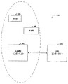
図1を最初に参照すると、モバイル計算デバイスがその位置を決定することを可能にするシステム100が例示されている。モバイル計算デバイスは、モバイル、ポータブル、または計算デバイスとしてよい。システム100は、外部環境コンポーネント102および分析コンポーネント104を備え、両方とも、モバイルコンピューティングデバイスなどの、ユーザデバイス上にあってよい。それとは別に、またはそれに加えて、外部環境コンポーネント102は、ユーザデバイス上に配置することができ、また分析コンポーネント104は、Webサービスなどの外部デバイス上に配置することができる。
With initial reference to FIG. 1, illustrated is a
外部環境コンポーネント102は、モバイルデバイスのローカル領域(点線の領域で示されている)をスキャンするように適合され、検出可能な範囲内にあるすべての基地局に対する探索を実行する。デバイスに応じて、これらの基地局は、Wi−Fi(802.11)アクセスポイント、携帯電話アンテナ塔、AM無線局、FM無線局、TV局、または電磁波、音波、または基地局で検出され識別されうる任意の信号を放射するこれらの基地局または任意の基地局の組合せを含む、位置が知られている(複数の)基地局106からの他の種類の無線伝送とすることができる。基地局は、(複数の)基地局108などの移動局としてよいが、ただし、そのような基地局の位置は、それらが配置されたときと実質的に類似の時刻に決定することができると仮定する。外部環境コンポーネント102は、さらに、検出されたそれぞれの基地局106または108から受信された検出信号の強度または他の品質を測定するように適合される。複数の基地局を検出することができ、本発明は、検出された基地局の数により限定されないことは理解されるであろう。
The
スキャンされた基地局から導き出された情報に基づき、外部環境コンポーネント102は、どの基地局が検出されたかを決定する分析コンポーネント104と通信するか、またはインターフェースする。例えば、分析コンポーネント104は、知られているすべての基地局の位置(経度、緯度、高度)を含むデータベースまたはルックアップテーブルを有することがある。分析コンポーネント104は、外部環境コンポーネント102から受信された情報を知られている基地局と比較し、外部環境コンポーネント102の位置を決定または計算することができる。分析コンポーネント104は、位置情報を外部環境コンポーネント102およびモバイルデバイスの関連するユーザに伝達する。
Based on information derived from the scanned base stations, the
システム100は、「無線測位システム」とも呼ばれ、位置を計算し、および/またはデータベースのセルフメンテナンスを実行するために使用することができる情報を含むデータベースを利用することができる。データベースの内容は、無線システムおよび/または位置に使用される電子エンドポイントの種類に依存する。
一実施形態では、分析コンポーネント104は、ユーザデバイス位置を計算し、そのような計算は、基地局座標x i のデータベースも保持するユーザのデバイス上で実行される。他の実施形態では、基地局のデータベースは、ネットワークアクセス可能なデータベース内に保持され、ユーザのデバイスは、このデータベースと通信して、基地局座標を取得する。他の実施形態では、位置計算コンポーネントおよびデータベースが、ネットワークアクセス可能な位置に存在する。このような方法で、ユーザのデバイスは、検出された基地局データをネットワークを介して送信し、ネットワーク側では計算された位置で応答する。基地局位置のデータベースをネットワークサーバ上に保持すると、ユーザのデバイス側ではこのデータに自身のメモリを使用する必要性が緩和され、および/またはデータベースの最新版にアクセスすることができる。しかし、ユーザのデバイスがネットワークアクセスできない場合、データのローカルコピーをデバイスに置かなければならない。
In one embodiment, the
データベースがユーザのデバイス上に置かれている場合、デバイスをネットワークに(一時的にまたは継続的に)接続しておきながら、ネットワークからデータベース情報を取得する方法は多数ある。一実施形態によれば、ユーザは、ダウンロードのためデータベースの部分集合を手動で指定することができる。この部分集合は、ユーザがいると予想される地理的領域を包含している可能性がある。他の実施形態によれば、システムは、デバイスがネットワークに接続されている間にユーザの現在位置を自動的に計算し、現在の計算された位置を中心とするデータベースの部分集合をダウンロードする。他の実施形態によれば、ユーザのデバイスは、ネットワークアクセスができる限りネットワークに日和見的に接続し、デバイスの現在位置を中心とするデータベースの部分集合をダウンロードする。他の実施形態では、デバイスは、予測技術を使用して、将来ユーザが置かれるであろう場所を推論し、予測された位置を中心とするデータベースのサブセクションを日和見的にダウンロードする。 If the database is located on the user's device, there are many ways to obtain database information from the network while keeping the device connected (temporarily or continuously) to the network. According to one embodiment, the user can manually specify a subset of the database for download. This subset may encompass the geographic region where the user is expected to be. According to another embodiment, the system automatically calculates the user's current location while the device is connected to the network and downloads a subset of the database centered on the current calculated location. According to another embodiment, the user's device connects to the network as opportunistically as possible with network access and downloads a subset of the database centered on the device's current location. In other embodiments, the device uses prediction techniques to infer where the user will be placed in the future, and opportunistically download a subsection of the database centered on the predicted location.
システム100は、さらに、ユーザがそのようなユーザの位置を他のユーザに伝達できるよう適合される。例えば、ソーシャルアプリケーション(例えば、Instant Messenger)は、(複数の)ユーザが自分の位置を決定するか、または取得するか、または計算するための事前許諾を与えた「友達」または「コンタクト」のリスティングを格納することができる。近接アラートを含めることができ、この場合、ユーザは、「コンタクト」が、例えばそのようなユーザの1マイル(1.6km)以内にいる場合に通知される。ユーザは、自分が「コンタクト」と通信し、そのような通信を開始し、および/または会う時間/場所を要求したいかどうかを決定することができる。システム100は、知られている位置に基づいて、注目している場所を決定することができ、そこで、ユーザと「コンタクト」は出会うことができる。
The
システム100は、さらに、アセットおよび人のリアルタイムの追跡などの位置情報サービスを提供することもできる。連動型広告を含む、情報配信は、ユーザの現在位置、位置履歴、および/または将来の予想位置に基づいて行うことができる。システム100は、特定のユーザにとって重要な、様々な媒体の強化されたプレゼンスおよび/または位置タグ付けを通してリアルタイムコラボレーションを提供することができる。
The
図2は、モバイル計算デバイスの位置を決定するためのシステム200を例示する。当業者であれば、本明細書で説明されているコンポーネントおよび/またはモジュールは、ユーザデバイス、リモートステーションと組み合わせたユーザデバイス、リモートステーションと中央集中型ネットワークと組み合わせたユーザデバイスに関連付けることができることを理解するであろう。
FIG. 2 illustrates a
システム200は、1つまたは複数の基地局206および208に関連付けられている信号を検出または受信する外部環境コンポーネント202を備える。外部環境コンポーネント202は、少なくとも一部は外部環境コンポーネント202から受信された情報に基づきユーザデバイスの位置を決定する分析コンポーネント204とインターフェースする。位置情報を使いやすくするために、外部環境コンポーネント202は、検出コンポーネント210、測定コンポーネント212、および通信コンポーネント214を備えることができる。
検出コンポーネント210は、受信または取得された信号に基づきユーザデバイスの局所的に近い位置にある基地局を検出するように適合される。基地局信号および情報の探索または収集は、連続的、周期的、またはオンデマンドとしてよく、ユーザアクションにより、システム200により自律的に、および/またはリモートサービスからの要求に応じて開始することができる。例えば、検出コンポーネント210は、基地局がないか通信環境をスキャンすることができる。スキャンの結果は、基地局識別子の集合とすることができ、受信特性を含むことができる。例えば、Wi−Fiアクセスポイントをスキャンした結果は、それぞれの検出されたアクセスポイントに対するMACアドレスであり、それぞれの検出されたアクセスポイントの信号強度を含むことができる。携帯電話アンテナ塔をスキャンすると、携帯電話アンテナ塔識別子およびそれぞれの検出された携帯電話アンテナ塔の信号強度を受信または取得することができる。受信特性は、信号強度に加えて、または信号強度の代わりに得られるか、または受信できる。代替え受信特性への一例は、基地局について複数回スキャンすることにより計算される、基地局の検出確率である。
The
検出コンポーネント210により得られた情報は、受信特性を計算することができる測定コンポーネント212に伝達することができ、これは基地局の検出確率の尺度とすることができる。検出確率は、基地局を繰り返しスキャンし、特定の基地局が検出された回数とスキャンの総回数との比を計算することにより測定することができる。受信特性は、信号強度および検出確率とすることができ、またそれぞれを、位置決定システムの一部として利用することができるが、他の検出確率および/または受信特性を、信号強度の代わりに、またはそれに加えて利用することができる。このような修正形態はすべて、本明細書および付属の請求項の一部であることが意図されている。
The information obtained by the
検出コンポーネント210および測定コンポーネント212から得られた情報は、通信コンポーネント214により分析コンポーネント204に伝送される。通信コンポーネント214は、分析コンポーネント204に情報を伝達し、分析コンポーネント204から情報を受信するように適合されている。情報は、通信コンポーネント216との間で定期的に、連続的に、要求があったときなどに伝送されるようにできる。
Information obtained from the
次に図3を参照すると、基地局信号の分析に基づき位置情報を決定するシステム300が例示されている。システムは、分析コンポーネント304とインターフェースする外部環境コンポーネント302を備える。外部環境コンポーネント302は、1つまたは複数の基地局(固定局106および/または移動局108)から信号を受信または取得することができる。これらの信号は、検出コンポーネント310により検出され、測定コンポーネント312により測定され、通信コンポーネント314により分析コンポーネント304に伝達される。外部環境コンポーネント302および分析コンポーネント304は、別のデバイス(例えば、ユーザデバイスおよびWebサービス)、同じデバイス(例えば、モバイルユーザデバイス)上にあってもよい。
Now referring to FIG. 3, illustrated is a
例えば、アプリケーションは、ローカルアプリケーションプログラムインターフェース(API)を呼び出すか、またはWebサービスにアクセスして、位置情報を直接取得することができる。それとは別に、またはそれに加えて、位置情報は、計算または受信されると、仮想GPS類似デバイス内に抽象することができ、本明細書で開示されている測位技術を明確に意識する位置情報アプリケーションなしでローカルアプリケーションにより使用することができる。例えば、本明細書で説明されているシステムおよび/または方法は、通信ポートをエミュレートし、位置情報を記述するNMEA準拠ストリームを生成することができる。NMEA位置データを消費する既存のアプリケーション(例えば、GPSにアクセスする大半のアプリケーション)は、利用する位置データの新しいソースを持つことになる。 For example, an application can call a local application program interface (API) or access a web service to obtain location information directly. Alternatively or in addition, location information can be abstracted into a virtual GPS-like device when it is calculated or received, and location information applications that are clearly aware of the positioning techniques disclosed herein. Can be used by local applications without For example, the systems and / or methods described herein can emulate a communication port and generate an NMEA-compliant stream that describes location information. Existing applications that consume NMEA location data (eg, most applications that access GPS) will have a new source of location data to use.
分析コンポーネント304は、通信コンポーネント314と分析コンポーネント304に配置されているインターフェースコンポーネント316との間の双方向のやり取りを通じて基地局識別子および受信特性を受け取る。外部環境コンポーネント302および分析コンポーネント304が両方ともモバイルユーザデバイス上に配置されている場合、通信コンポーネント314およびインターフェースコンポーネント316は、外部環境コンポーネント302のコンポーネントと分析コンポーネント304との間の通信インターフェースを備える一コンポーネントとすることができることは理解されるであろう。このような修正形態はすべて、本明細書および付属の請求項の一部であると考えられる。
The
分析コンポーネントは、さらに、識別子コンポーネント318および計算コンポーネント320を含むことができる。識別子コンポーネント318は、データベース、ルックアップテーブル、問い合わせ分析、または外部環境コンポーネント302により受信された基地局識別子に基づき特定の基地局を識別するための手段を含むことができる。
The analysis component can further include an
データベースの内容は、無線システムおよび/または位置目的に使用される電子エンドポイントの種類に依存する。データベースは、ユーザデバイスの位置配置を決定する、計算する、取得するなどのために必要な少なくとも最小限度の情報を含むべきである。例えば、データベースは、無線ビーコンまたは電子エンドポイントを一意に識別することができるビーコンまたは電子エンドポイント情報を含むべきである。緯度、経度、および/または高度情報は、データベースに含まれているべきである。位置不確定性情報は、含めてもよく、また単純な球体不確定性および/または位置誤差の詳細な記述であってよい。位置信頼度情報も、データベースに含めることができる。位置信頼度情報は、ビーコンおよび/またはエンドポイント識別に利用可能な位置情報の相対的信頼度にアクセスするために利用されるデータの集まりである。位置信頼度情報も、またはそれとは別に、最後に更新された日付、最後に報告されたデータ、レポート数、不在レポート数(このエンティティを含まないが、密接に関連するエンティティを含むレポート)、および/またはエラーレポート数などの情報を含むことができる。 The content of the database depends on the type of electronic endpoint used for the wireless system and / or location purposes. The database should contain at least the minimum information necessary to determine, calculate, obtain, etc. the location of the user device. For example, the database should include beacon or electronic endpoint information that can uniquely identify a wireless beacon or electronic endpoint. Latitude, longitude, and / or altitude information should be included in the database. The position uncertainty information may be included and may be a detailed description of simple sphere uncertainty and / or position error. Location reliability information can also be included in the database. Location confidence information is a collection of data used to access the relative confidence of location information available for beacon and / or endpoint identification. Location reliability information also or separately, date last updated, last reported data, number of reports, number of absent reports (reports that do not include this entity but include closely related entities), and Information such as the number of error reports can be included.
基地局データは、デバイスのローカル(ユーザデバイス上)および/または外部にあるか、組合せとすることもできる。ユーザがローカルユーザデバイス上でこのサービスを実行することを選択した場合、デバイスは、基地局位置のデータベースの少なくとも一部を取得する。この情報を取得する一例は、ユーザが、サービスを利用している間にそのようなユーザがいる、または滞在していると予想される地域、例えば、シアトル地域、キング郡、またはワシントン州を手動で指定するものである。 The base station data may be local (on the user device) and / or external to the device or a combination. If the user chooses to perform this service on the local user device, the device obtains at least a portion of the base station location database. An example of obtaining this information is to manually locate the region where such a user is expected or stays while using the service, for example, Seattle, King County, or Washington. It is specified by.
地域を指定する他の例では、ユーザの現在位置を計算するためにWebサービスを少なくとも1回使用する。サービスは、ユーザの計算された位置を中心とする所定の半径(例えば、10マイル(16km)、50マイル(80.5km)、100マイル(161km))内の基地局データベースのサブセクションを配信することができる。ユーザのデバイスは、ネットワークが利用可能なときに、Webサービスに位置更新を定期的に問い合わせることができる。それに加えて、またはそれとは別に、ユーザが他の地域内に移動するか、または所定の半径の縁に近づいた場合、ユーザは、基地局の他の計算された位置および/またはサブセクションを要求することができる。デバイスは、さらに、受信されたデータベース情報の部分集合に含まれていない基地局が検出された場合に情報を自動的に要求することもできる。このような方法で、デバイスは、所定の半径から外に出たため、追加または代替えの基地局情報が必要であると推論する。Webサービスは、ユーザのローカルデバイスに配信すべき基地局データベースの新しいサブセクションで応答することができる。それに加えて、デバイスまたはWebサービスは、新しい基地局情報が与えられたときに、デバイスから基地局情報の以前の部分集合を削除するか、または引き出すことができ、これによりユーザデバイスのメモリ資源を節約することができる。 In another example of specifying a region, the web service is used at least once to calculate the user's current location. The service delivers a subsection of the base station database within a predetermined radius (eg, 10 miles (16 km), 50 miles (80.5 km), 100 miles (161 km)) centered on the user's calculated location. be able to. The user's device can periodically query the web service for location updates when the network is available. In addition or alternatively, if the user moves into another region or approaches an edge of a predetermined radius, the user requests other calculated locations and / or subsections of the base station can do. The device may also automatically request information when a base station is detected that is not included in the received subset of database information. In this way, the device infers that additional or alternative base station information is needed because it has gone out of a predetermined radius. The web service can respond with a new subsection of the base station database to be delivered to the user's local device. In addition, the device or web service can delete or retrieve the previous subset of base station information from the device when new base station information is given, thereby freeing up user device memory resources. Can be saved.
将来のニーズを予想するため、予測モジュールにより、ユーザの将来の(複数の)位置を過去の挙動に基づいて予測することができる。これらの予測結果を用いて、ユーザのデバイスは、ユーザが行くと予想される場所を対象とするデータベースの新しいサブセクションを自動的におよび/または自律的に取得することができる。このような方法で、機械学習および推論モジュールを使用して、そのような(複数の)ユーザアクションを推論することができる。 To predict future needs, the prediction module can predict the future location (s) of the user based on past behavior. Using these prediction results, the user's device can automatically and / or autonomously obtain a new subsection of the database that covers where the user is expected to go. In this way, machine learning and reasoning modules can be used to infer such user action (s).
分析コンポーネント304は、さらに、基地局識別子および受信特性を使用してユーザデバイスまたは受信機の位置を決定する計算コンポーネント320を含む。ユーザデバイスの位置を三角測量するために数式を受信特性に適用することができる。例えば、重み付き平均は、ユーザデバイス位置を計算するために使用することができ、また式
The

に基づいて計算できる。 Can be calculated based on
上の式で、xは、計算された位置座標のベクトルである。 In the above equation, x is a vector of calculated position coordinates.
x i 座標は、検出された基地局の位置であり、その数はNである。重みwiは、それぞれの基地局受信特性から計算される。例えば、受信特性が信号強度siである場合、重みは、 The x i coordinate is the position of the detected base station, and its number is N. The weight w i is calculated from each base station reception characteristic. For example, if the reception characteristic is signal strength s i , the weight is
![]()
![]()
とすることができ、n’は、理論的または実験的分析である、分析結果に基づいて精度を最大にするように選択された指数である。 N 'is an exponent selected to maximize accuracy based on the results of the analysis, which is a theoretical or experimental analysis.
次に図4を参照すると、システム精度および/またはユーザ信頼度を高めるコンポーネントおよび技術を使用する位置決定システム400が例示されている。システム400に関連付けられているものとして示されている例示的なコンポーネントは、オプションである。それに加えて、オプションのシステム400は、例示されているすべてのコンポーネントを使用する必要はなく、1つまたは複数のコンポーネントを、任意の構成でシステム400とともに使用することができる。このような変更形態または修正形態はすべて、本明細書および付属の請求項の範囲内にある。システム400は、図1、2、および3を参照しつつ示され、説明されているものと類似している。
Referring now to FIG. 4, a
いくつかの状況において、モバイルデバイスに関連付けられているユーザに計算された位置の精度の推定を提供すると役立つ。不確定性コンポーネント422では、ユーザにこのような推定を提供する。例えば、外部分析コンポーネント402(または検出コンポーネント410)が、ただ1つの基地局406または408を検出した場合、不確定性コンポーネント422は、その基地局406または408の周りの位置の確率分布を、平均が基地局の406または408の座標と一致するガウス分布としてモデル化することができる。ガウス分布は、データベース内のデータ点の固有の精度により修正される、無線信号の伝播特性に関係する。この確率関数に対する式は、
In some situations, it is helpful to provide a user associated with the mobile device with an estimate of the calculated location accuracy. The
として表すことができる。 Can be expressed as
上記の式において、nは、位置ベクトルの次元の数である。二次元の場合、n=2であり、μは、単一の検出された基地局406または408の位置である
In the above formula, n is the number of dimensions of the position vector. In the two-dimensional case, n = 2 and μ is the position of a single detected
![]()
![]()
に等しい。共分散行列Σが、空間内の確率の広がりを決める。この広がりが平均を中心として放射状に対称的になるようにする妥当な設定は、 be equivalent to. The covariance matrix Σ determines the spread of probability in space. A reasonable setting to make this spread radially symmetric around the mean is
である。例えば、Wi−Fiまたは802.11基地局の場合、σの妥当な値は、30メートルである。この状況における対応する二乗平均平方根(rms)誤差は、 It is. For example, for Wi-Fi or 802.11 base stations, a reasonable value for σ is 30 meters. The corresponding root mean square (rms) error in this situation is
![]()
![]()
であり、これは、システム400の精度の指標としてユーザに報告するのに理解しやすい値である。
This is an easily understandable value to report to the user as an indicator of the accuracy of the
複数の基地局が外部分析コンポーネント402(または検出コンポーネント410)により検出された場合、位置の確率分布関数は、不確定性コンポーネント422により、ガウス分布の混合分布としてモデル化することができ、
If multiple base stations are detected by the external analysis component 402 (or detection component 410), the probability distribution function of the location can be modeled by the
として表すことができる。 Can be expressed as
ただし、Nは、検出された基地局の個数であり、 Where N is the number of detected base stations,
![]()
![]()
は、計算コンポーネント420により使用される、三角測量公式内で使用されている重みの正規化されたバージョンであり、
Is a normalized version of the weights used in the triangulation formula used by the
として表すことができ、pi(x)は、基地局iに対するガウス分布 Where p i ( x ) is the Gaussian distribution for base station i
であり、u i は、基地局iの位置であり、Σiは、基地局iに対する共分散行列である。 U i is the position of the base station i, and Σ i is the covariance matrix for the base station i.
ガウス分布の混合分布は、確率「こぶ」の総和であり、それぞれのこぶは1つの検出された基地局を表す。こぶの高さは、大きな確率質量ほど重みの大きい(複数の)基地局の近くに置く傾向があるときに、それぞれの基地局について計算された重みにより決まる。ガウス分布の混合分布の平均は、 The Gaussian distribution mixture is the sum of the probabilities “humps”, where each hump represents one detected base station. The height of the hump is determined by the weight calculated for each base station when the larger the probable mass tends to be placed near the higher weighted base station (s). The average of the Gaussian mixture distribution is
と表すことができる三角測量された位置と数学的に同等である。 It is mathematically equivalent to a triangulated position that can be expressed as
ガウス分布の混合分布の共分散は、 The covariance of the Gaussian mixture distribution is
として計算することができる。 Can be calculated as
上記共分散行列の固有値と固有ベクトルは、実際の位置が既存のものの特定の確率を持つ計算された位置の周りの空間を記述するものである。これは計算された位置の不確定性をほとんど完全に記述しているが、ときには、代わりにrms誤差の単純な球面不確定性を与えることが望ましい場合もある。共分散行列のn個の固有値がλ1、λ2、...λnである場合、ユーザに報告する好適な精度値としてよいrms誤差は、 The eigenvalues and eigenvectors of the covariance matrix describe the space around the calculated position where the actual position has a certain probability of existing ones. This describes the calculated position uncertainty almost completely, but sometimes it may be desirable to instead give a simple spherical uncertainty of the rms error. The n eigenvalues of the covariance matrix are λ 1 , λ 2 ,. . . If λ n , the rms error, which can be a good accuracy value to report to the user
として表すことができる。 Can be expressed as
不確定性コンポーネント422により計算された、位置情報の不確定性は、そのようなユーザの位置の計算の正確さをユーザに知らせるために使用することができる。例えば、ユーザデバイスのディスプレイ上のアイコンの色、形状、サイズなどを変化させて、ユーザが不確定性を知覚できるように、および/または素早くユーザに示すようにできる。それとは別に、またはそれに加えて、システム400は、ユーザディスプレイの地図上に確定境界を描き、信頼地域のサイズを示すことができる。
The uncertainty of the location information calculated by the
ユーザデバイスは、様々な種類のユーザインターフェースを備えることができる。例えば、ユーザデバイスは、グラフィカルユーザインターフェース(GUI)、コマンドラインインターフェースなどを備えることができる。例えば、GUIをレンダリングすることで、1つまたは複数の不確定性指標および/または位置のロード、インポート、読み込みなどを行う領域または手段をユーザに示すことができ、またGUIは、そのようなものの結果を提示する領域を含むことができる。これらの領域は、ダイアログボックス、静的コントロール、ドロップダウンメニュー、リストボックス、ポップアップメニュー、エディットコントロール、コンボボックス、ラジオボタン、チェックボックス、プッシュボタン、およびグラフィックボックスを含む知られているテキストおよび/またはグラフィック領域を備えることができる。それに加えて、ナビゲーション用の垂直および/または水平スクロールバーおよび領域を表示可能であるかどうかを決めるツールバーボタンなどの提示を容易にするユーティリティを使用することができる。 The user device can include various types of user interfaces. For example, the user device can comprise a graphical user interface (GUI), a command line interface, and the like. For example, rendering a GUI may indicate to the user an area or means for loading, importing, reading, etc. one or more uncertainty indicators and / or locations, and the GUI may An area for presenting results can be included. These areas include known text and / or dialog boxes, static controls, drop-down menus, list boxes, pop-up menus, edit controls, combo boxes, radio buttons, check boxes, push buttons, and graphic boxes. A graphics area can be provided. In addition, utilities that facilitate presentation such as toolbar buttons that determine whether vertical and / or horizontal scroll bars and areas for navigation can be displayed can be used.
ユーザは、これらの領域と双方向でやり取りし、例えばマウス、ローラーボール、キーパッド、キーボード、ペンおよび/または音声駆動などの様々なデバイスを介して情報を選択し、提供することができる。典型的には、プッシュボタンまたはキーボード上のエンターキーなどのメカニズムを使用して、その後に、情報を入力し、情報伝達を開始することができる。しかし、(複数の)実施形態はこのように制限されていないことは理解されるであろう。例えば、単にチェックボックスをハイライト表示にするだけで、情報伝達を開始することができる。他の例では、コマンドラインインターフェースを使用することができる。例えば、コマンドラインインターフェースは、テキストメッセージを表示することで、ユーザに情報を入力するよう求めることができる(例えば、ディスプレイ上のテキストメッセージおよび音声を介して)。次いで、ユーザは、インターフェースプロンプトにおいて、またはプロンプト内に提示された質問に答える形で、予想される、または実際の知られているユーザ地域(例えば、大クリーブランド地域、カイヤホガ郡、および/またはオハイオ州)に対応する英数字入力などの適当な情報を与えることができる。コマンドラインインターフェースは、GUIおよび/またはAPIとともに使用することができることは理解されるであろう。それに加えて、コマンドラインインターフェースは、グラフィックサポートが限られている、および/または通信チャネルの帯域幅が低いハードウェア(例えば、ビデオカード)および/またはディスプレイ(例えば、白黒、およびEGA)とともに使用することができる。 A user can interact with these areas and select and provide information via various devices such as a mouse, rollerball, keypad, keyboard, pen and / or voice drive. Typically, a mechanism such as a push button or an enter key on the keyboard can be used to subsequently enter information and initiate information transmission. However, it will be understood that the embodiment (s) are not so limited. For example, information transmission can be started simply by highlighting a check box. In other examples, a command line interface can be used. For example, the command line interface may prompt the user to enter information by displaying a text message (eg, via text message and voice on the display). The user then responds to the question presented in the prompt or in the form of an expected or actual known user region (eg, Greater Cleveland Region, Cuyahoga County, and / or Ohio) ) Can be given appropriate information such as alphanumeric input. It will be appreciated that the command line interface can be used with a GUI and / or API. In addition, the command line interface is used with hardware (eg, video cards) and / or displays (eg, black and white, and EGA) that have limited graphics support and / or low communication channel bandwidth. be able to.
システム400に関連付けることができる他のオプションコンポーネントは、識別子コンポーネント418(例えば、データベース、ルックアップテーブル、問い合わせ分析、または特定の基地局を識別する手段)を更新することができる学習コンポーネント424とすることができる。ときどき識別子コンポーネント418により特定され、使用される基地局データベースは、新しい基地局が追加されるか、移動されるか、またはサービス提供が停止されると古くなってしまう可能性がある。基地局検出結果がネットワークデータベースに送信されるときに、それらのサブミットを分析して、データベースを更新することが可能である。これらの更新により、識別子コンポーネント418を最新状態に保つことができ、しかも、明示的な双方向のやり取りまたは更新をデータベースメンテナンス担当者および/またはアドミニストレーター側で行わなくてよい。
Another optional component that can be associated with the
一実施形態によれば、学習コンポーネント424は、基地局サブミットの集合を分析する。サブミットされた基地局の一部は、システム400に知られているが、他は、知られていないか、確認されていないか、および/または認識されていない。これらの未知の基地局は、知られている基地局について計算された位置をタグとして付けて、データベースに加えることができる。計算された位置は、この情報に基づき不正確な場合があるが、それは、1回の探知または検出に基づいて計算されるからである。これらの以前には知られていない基地局はタグ付けされ、それらが、1回、2回、3回などの探知に基づいており、不正確な場合があることを示すようにできる。これらの基地局が他のユーザにより検出されるか、または確認されると、それらの位置を更新することができる。例えば、更新は、すべての探知(検出)結果の計算されたすべての位置の平均位置を含むことができる。これらの以前には知られていない局の位置が特定の所定の信頼水準を超えると、それらの局は、一般データベース内でアクティブ化され、測位分析に使用できるようになる。新しい基地局を見つけることに加えて、またはそれとは別に、受信データを分析することで、データベースの誤ったエントリを訂正し、および/または削除することができ、また後述の誤りデータコンポーネント426と連携して使用することができる。
According to one embodiment, the
システム400は、誤りのある、または誤りのある情報を提供している基地局および/またはユーザを識別する、削除する、検疫する、タグ付けするなどを行うように適合された誤りデータコンポーネント426を備える。基地局位置のデータベースは、偶発的に、または悪意から間違った基地局位置を含んでいる可能性がある。上述の三角測量アルゴリズムは、データベースから誤りのあるエントリをタグ付けするか、および/または削除することによりこれらの識別された、間違っている位置を使用しないように、「強化」することができる。一実施形態によれば、データベースから返されたすべての検出された基地局の位置を調べることができる。三角測量を実施する前に、互いの現実的な範囲内にすべてある基地局の最大の部分集合を見つけることができる。この範囲は、典型的な基地局の予想される検出範囲の2倍として計算することができる。予想検出範囲の2倍としたのは、ユーザのデバイスがこの距離を超えて隔てられている2つの基地局を検出しないであろうからである。相互に妥当な範囲内にある基地局の最大部分集合により、ランダムな外れ値となる基地局を排除すべきである。
The
他の実施形態によれば、偽の測位結果は、ユーザの挙動について推論することにより減らすことができる。ユーザの速度は制限されており(物理的限界に基づく)、したがって、最後に計算された位置以降の最高速度および経過時間により課せられる「バブル」の外にある計算された位置を排除することができる。例えば、ユーザは、サウスダコタの1つまたは複数の基地局を物理的に検出することができないが、30分後には、フロリダの1つまたは複数の基地局を検出することができる。誤りデータコンポーネント426は、位置、速度、時間などを含む多数の要因に基づき、最後に位置していた、検出された、確認された基地局から導き出されるものとして可能な基地局位置を決定することができる。
According to other embodiments, false positioning results can be reduced by inferring user behavior. The user's speed is limited (based on physical limits), thus eliminating calculated positions that are outside the “bubble” imposed by the maximum speed and elapsed time since the last calculated position. it can. For example, a user cannot physically detect one or more base stations in South Dakota, but can detect one or more base stations in Florida after 30 minutes. The
上述のように、システム400を使用する通常の過程においてユーザによりサブミットされた基地局データは、基地局位置のデータベースを更新するために利用することができ、この情報も、ログに記録されるか、または後から分析するため保持されるようにできる。それとは別に、またはそれに加えて、システム400は、知られていないビーコンを検出することができ、時間と反復相関により、それらのビーコンの位置および他の関連する情報を調べ、データベースに追加することができる。近隣のビーコンは検出されるのに特定のビーコンの検出がないということは、ビーコンが移動してしまった、運用されていないなどを示すものと考えられる。このデータ点は、フラグが立てられ、適切なときに、アクティブデータベースから削除されるようにできる。偶発的にせよ、故意にせよ、サブミットの一部は、実際には検出されていなかった基地局識別子を含む可能性がある。システム400は、基地局位置のデータベースを調べることにより外れ値を自動的に検出することができる。特定のユーザが、外れ値としてフラグが立てられている基地局にサブミットしていると判定された場合、またはユーザ情報の精度が許容レベルよりも低い場合に、そのユーザは潜在的に悪意があるとしてフラグが立てられ、その後のすべてのサブミットは、無視されるか、検疫されるか、フラグが立てられるなどの処置が行われうる。例えば、ユーザの双方向のやり取りは、基地局の集合に関連付けられている情報およびそのような情報をサブミットしたユーザに関係する情報を保持しているログまたは追跡コンポーネント428内に保持することができる。このデータは、基地局データを改善し、履歴データを保持することができるため悪意のあるユーザを検出するために使用することができる。
As mentioned above, base station data submitted by the user in the normal course of using the
図1、2、3、および4に関して上で説明されているシステム100〜400のいくつかの部分は、代替えコンポーネント、モジュール、システムなどとモジュール形式で置き換えることができることは理解されるであろう。例えば、三角測量計算は、ユーザのタスクにより適していると思われる異なる種類の三角測量計算で置き換えることができる。「プラグイン」モジュールとして機能しうるシステムの部分は、ラジオプロバイダを含む。上述のように、システムは、異なる種類の無線通信、例えば、Wi−Fiまたは802.11、携帯電話アンテナ塔、FM、AM、TVなどと連携しうる。それぞれの種類の無線通信は、(複数の)システム内で置き換えるか、または「プラグイン」することができる、異なるプロバイダと考えられる。 It will be appreciated that some portions of the systems 100-400 described above with respect to FIGS. 1, 2, 3, and 4 can be modularly replaced with alternative components, modules, systems, and the like. For example, the triangulation calculation can be replaced by a different type of triangulation calculation that may be more suitable for the user's task. The part of the system that can function as a “plug-in” module includes a radio provider. As described above, the system may work with different types of wireless communications, such as Wi-Fi or 802.11, mobile phone antenna tower, FM, AM, TV, etc. Each type of wireless communication is considered a different provider that can be replaced or “plugged in” within the system (s).
モジュール形式で置き換えられる他のコンポーネントは、計算コンポーネントに関連する三角測量である。他の種類の三角測量は、精度、計算速度、異なる種類の無線通信を入力として得られる能力などに関して、ユーザのタスクにより適している場合がある。 Another component that is replaced in modular form is triangulation associated with the computational component. Other types of triangulation may be more appropriate for the user's task with respect to accuracy, calculation speed, ability to obtain different types of wireless communications as inputs, and so on.
それとは別に、またはそれに加えて、状況に応じて、他の種類の不確定性推定が適していることもある。例えば、いくつかの不確定性コンポーネントでは、ユーザの速度、加速度、方向などを考慮することができる。そのため、ユーザが知られている方向に特定の速度で移動している場合、不確定性コンポーネントは、そのような分析を計算に分解することができる。 Alternatively or in addition, other types of uncertainty estimates may be appropriate depending on the situation. For example, some uncertainty components can take into account the user's speed, acceleration, direction, etc. As such, the uncertainty component can break down such an analysis into a calculation if the user is moving in a known direction at a particular speed.
次に図5を参照すると、モバイルデバイスの位置を決定するための方法500の流れ図が例示されている。説明を簡単にするために、本明細書で説明されている方法が図に示され、一連の活動として記述されているが、本発明の方法は、活動の順序によって制限されるわけではなく、本発明の方法により、いくつかの活動は、図に示され、本明細書で説明しているのと異なる順序で、および/または他の活動と同時に実行することも可能であることが理解され、認識されるであろう。例えば、当業者であれば、代替えとして方法を一連の相互に関連のある状態またはイベントとして状態図などの中に表されることが可能であることを理解し、認識するであろう。さらに、以下の方法を実施するために、例示されているすべての活動が必要なわけではない。
Now referring to FIG. 5, a flowchart of a
方法500は、502から開始し、そこで、無線基地局の探索が実行または実施される。無線基地局は、Wi−Fi(802.11)アクセスポイント、携帯電話アンテナ塔、AM無線局、FM無線局、TV局、または基地局からの他の種類の無線伝送とすることができる。基地局は、知られている位置を有することが可能であり、移動局とすることができるが、ただし、検出されたときに基地局の位置を識別するためのメカニズムが適所にあると仮定する。
この方法は、504に続き、(複数の)基地局の識別子および受信特性が受信される。例えば、Wi−Fiアクセスポイントをスキャンした結果は、それぞれの検出されたアクセスポイントに対するMACアドレスおよび信号強度とすることができる。携帯電話アンテナ塔のスキャンを行うと結果として、携帯電話アンテナ塔の識別および対応する信号強度が得られる。受信特性は、信号強度、基地局の検出確率の尺度などを含むことができる。検出確率は、基地局を繰り返し(連続的または周期的に)スキャンし、特定の基地局が検出された回数とスキャンの総回数との比を計算することにより測定することができる。 The method continues at 504 where base station identifier (s) and reception characteristics are received. For example, the result of scanning a Wi-Fi access point can be the MAC address and signal strength for each detected access point. Scanning the cell phone antenna tower results in the identification of the cell phone antenna tower and the corresponding signal strength. Reception characteristics can include signal strength, a measure of base station detection probability, and the like. The detection probability can be measured by scanning the base station repeatedly (continuously or periodically) and calculating the ratio of the number of times a particular base station is detected and the total number of scans.
基地局識別子および受信特性は、受信機またはユーザデバイスの位置を計算するために、506において使用できる。例えば、三角測量、または類似のアルゴリズムは、検出された基地局およびその信号強度に基づいてユーザの位置を計算するために使用することができる。また、位置推定の不確定性を計算する技術も含めることができる。 The base station identifier and reception characteristics can be used at 506 to calculate the location of the receiver or user device. For example, triangulation, or similar algorithms, can be used to calculate the user's location based on the detected base station and its signal strength. A technique for calculating the uncertainty of position estimation can also be included.
不確定性を計算する例示的な方法は、確率関数の総和に基づくものである。それぞれの検出された基地局は、空間(緯度、経度)内に2D確率「こぶ」となって現れるようにできる。これらのこぶを足し合わせると、全体的な確率分布が得られ、これは、平均(緯度、経度)および/または平均を中心とする信頼領域として要約することができる。信頼領域のサイズは、報告される不確定性である。高度次元を計算に入れることによりこの方法を拡張して、3D測位不確定性を与えるようにできる。 An exemplary method for calculating uncertainty is based on the sum of probability functions. Each detected base station can appear as a 2D probability “kump” in space (latitude, longitude). Adding these bumps gives an overall probability distribution, which can be summarized as an average (latitude, longitude) and / or a confidence region centered on the average. The size of the trust region is the reported uncertainty. This method can be extended to include 3D positioning uncertainty by taking the altitude dimension into account.
不確定性を計算する他の例示的な方法は、実験データに基づくことができる。例えば、開示されている(複数の)技術の実際の測定された精度を検出された無線基地局の数の関数として与えるテーブルを作ることができる。ユーザが一定数の基地局を検出した場合、予想される精度をテーブルで見つけることができる。別のテーブルは、実際の測定された精度を実際に検出された基地局に応じて与えることができ、これは、不確定性として報告することが可能であろう。 Other exemplary methods for calculating uncertainty can be based on experimental data. For example, a table can be created that gives the actual measured accuracy of the disclosed technology (s) as a function of the number of detected radio base stations. If the user detects a certain number of base stations, the expected accuracy can be found in a table. Another table can give the actual measured accuracy depending on the actually detected base station, which could be reported as uncertainty.
ユーザがサービスを利用すると、ユーザが送信する基地局データが記録され、これにより、基地局データベースを更新し、成長させることができる。例えば、GPS受信機を備える一部のユーザは、緯度、経度、および/または高度データをその基地局データとともに送信することができる。この情報は、基地局位置のデータベースを更新するために直接使用することができる。同じユーザまたは他のユーザが、検出された基地局のリストで送信することができ、そのリストの一部は、データベースに含めることができ、また別の一部は、以前には知られていないか、識別されていないか、またはデータベースに含まれていない。サービスでは、サービス側で認識している基地局を使用してユーザの位置を計算することができる。次いで、サービスは、この計算された位置を知られていない基地局に付与し、データベースに追加することができる。これらの基地局は、未確認であることを示すフラグが立っていようと立っていまいと即座に追加することができ、および/または複数のユーザによる検出を通じて信頼水準が達成された後にのみ追加することができる。計算された位置の精度は、データベース内に間違いがあっても保持されうる(なりすまし防止と呼ばれる)。さらに、またはそれに加えて、一部のユーザに対し、偽情報をサブミットしている可能性があると判定された場合にフラグを立てることができる。 When the user uses the service, the base station data transmitted by the user is recorded, thereby updating and growing the base station database. For example, some users with GPS receivers can transmit latitude, longitude, and / or altitude data along with their base station data. This information can be used directly to update the base station location database. The same user or other users can transmit with a list of detected base stations, some of which can be included in the database, and some others are not previously known Or not identified or not included in the database. In the service, the user's location can be calculated using the base station known on the service side. The service can then grant this calculated location to an unknown base station and add it to the database. These base stations can be added immediately, whether or not flagged as unacknowledged, and / or only after a confidence level has been achieved through detection by multiple users. Can do. The accuracy of the calculated position can be maintained even if there is an error in the database (called anti-spoofing). In addition, or in addition, a flag can be set when it is determined that there is a possibility of submitting false information to some users.
開示されているシステム100〜400から得られる位置情報は、複数の方法でアプリケーションに配信することができ、そのうちのいくつかについて後述する。配信システムおよび/または方法の以下の例示的な説明は、例示する目的で述べられており、他の配信手段も使用することができ、詳細な説明および付属の請求項の範囲内にあることは理解されるであろう。 Location information obtained from the disclosed systems 100-400 can be distributed to applications in a number of ways, some of which are described below. The following exemplary descriptions of distribution systems and / or methods are set forth for illustrative purposes, and other distribution means may be used and are within the scope of the detailed description and appended claims. Will be understood.
本明細書で開示されているシステムおよび/または方法により決定される位置情報は、Webサービスを介し配信することができ、そのため、消費者プラットフォーム側は複雑なソフトウェアおよび/または広範囲に及ぶデータベースを用意する義務から解放される。アプリケーションは、開示されている測位サービスを使用することで、無線信号情報または分析される電子エンドポイントに適している他の情報を集めることができる。この情報をWebサービスに送信し、そこで、情報を位置に解決し、要求された情報をシステムおよび/またはユーザに送ることができる。 Location information determined by the systems and / or methods disclosed herein can be delivered via web services, so that the consumer platform provides complex software and / or an extensive database. Freed from the duty to do. The application can use the disclosed positioning service to gather radio signal information or other information suitable for the electronic endpoint being analyzed. This information can be sent to a web service where the information is resolved to a location and the requested information can be sent to the system and / or user.
例示的な実装は、SOAP/XML API(簡易オブジェクトアクセスプロトコル/拡張マークアップ言語アプリケーションプログラムインターフェース)であり、そこで鍵となるメソッドは、GetPositionである。GetPositionは、ビーコンまたは電子エンドポイント型および/またはビーコンまたは電子エンドポイントデータ配列を含むパラメータを取り込み、取得し、または決定することができる。この配列構造体のメンバーは、使用されるビーコンまたはエンドポイントの型に応じて変わりうる。概して、これらのメンバーは、識別子および/または品質を含み、これは、信号の品質を記述することができるコンポーネントである。品質コンポーネントの例は、信号強度および/または検出頻度を含むことができる。 An exemplary implementation is SOAP / XML API (Simple Object Access Protocol / Extensible Markup Language Application Program Interface), where the key method is GetPosition. GetPosition can capture, obtain, or determine parameters including beacon or electronic endpoint type and / or beacon or electronic endpoint data array. The members of this sequence structure can vary depending on the type of beacon or endpoint used. In general, these members include an identifier and / or quality, which is a component that can describe the quality of the signal. Examples of quality components can include signal strength and / or detection frequency.
この方法は、位置を記述する提案された、またオプションのデータフィールドの集合を含む、位置オブジェクトを返すことができる。位置オブジェクトは、提案されたフィールドとして少なくともLatitude、Longitude、TimeOfFix、および/またはCoordinate照合システムを持つことができる。これは、さらに、オプションフィールドとして、少なくともElevation、Uncertainty記述、および大きさ(これは、単純な球面誤差、rms誤差、および/または他のより広範な不確定性記述とすることができる)を持つこともできる。 This method can return a location object containing a proposed and optional collection of data fields describing the location. A location object can have at least Latitude, Longitude, TimeOfFix, and / or Coordinate match systems as suggested fields. It also has as optional fields at least Elevation, Uncertainty description, and magnitude (this can be a simple spherical error, rms error, and / or other broader uncertainty description). You can also
図6は、httpsハンドラおよび/またはWebサービスを使用して位置情報を利用するアプリケーションまたはブラウザ用の例示的なシステムおよびメッセージ流れ図を示している。システム600は、サードパーティ製アプリケーション602、ローカル無線測位コンポーネント604、プラザ606、公認されているWebサイトサーバ608、および測位機能を持つWebサーバを備える。このようなシステムを使用することで、ブラウザは、サーバと容易に双方向でやり取りし、ユーザの位置を取得し、位置関係の情報が多いコンテンツを配信することができる。ブラウザ、または他のソフトウェアは、無線通信(または他の電子エンドポイント)情報(識別および/または品質)を収集し、データをURL(Uniform/Universal Resource Locator)形式にしてhttp/httpsハンドラに送信することができる。例えば、https://locateme.com?RadioType=802.11&RadioID1=xxy&Quality1=0.2&RadioID2=xx2 &Quality2=0.4またはhttps://locateme.com?RadioInfo=trueとし、実際のデータは要求の本体中にある。http/httpsハンドラは、次いで、ブラウザまたはソフトウェアが位置情報を利用できるような適切な位置情報で応答することができる。
FIG. 6 illustrates an exemplary system and message flow diagram for an application or browser that utilizes location information using https handlers and / or web services. The system 600 includes a third-
次に以下では、図6および7を参照して、不正な当事者がユーザの正確な位置を発見するのを防ぎつつ、ブラウザが位置特有の情報をユーザに配信できるようにする実装について説明する。また、サードパーティ製アプリケーションも、ブラウザを起動し、ユーザの位置を安全に表示するようにすることもできる。 In the following, referring to FIGS. 6 and 7, an implementation will be described that allows a browser to deliver location-specific information to a user while preventing unauthorized parties from discovering the user's exact location. Third-party applications can also launch a browser and securely display the user's location.
位置に対する要求は、サードパーティ製アプリケーションにより、702で開始される。サードパーティ製アプリケーションは、704で、ブラウザを起動し、URLを渡し、位置が要求されていることを示す。このようなURLの例は、http://locateme?locateme=trueとすることができる。706で、locateme.comサーバは、例えば、このURLを認識し、ブラウザに、安全な位置トランザクションを開始するコマンドを送信することができる。ブラウザおよび/またはソフトウェアは、708で、ローカルデバイスから無線通信情報を集めることができる。 A request for a location is initiated at 702 by a third party application. The third-party application launches the browser at 704, passes the URL, and indicates that the location is requested. An example of such a URL can be http: // locateme? Locateme = true. 706, locateme. For example, the com server can recognize this URL and send a command to the browser to initiate a secure location transaction. The browser and / or software can collect wireless communication information from the local device at 708.
方法700は、710から続き、そこでは、セキュアhttps urlが必要な無線通信情報によりフォーマットされ、httpsハンドラによりWebサーバに送信される。例えば、URLは、https://locateme.com?RadioType=802.11&RadioID1=xxy&Quality1=0.2またはhttps://locateme.com?RadioInfo=trueとすることができ、他のデータは本体内に置かれている。712で、サーバは、安全なリンクで要求位置情報により応答することができる。ブラウザは、714で、このデータを使用して、カスタムコンテンツを要求することができる。このような要求および以下の要求は、通信プロトコルをおよび/またはユーザ設定に応じて安全なリンクを使用する場合も使用ない場合もある。
図8は、ローカルマシンまたはユーザデバイス上のAPIを介して位置情報にアクセスするシステム800を例示する。APIモジュール802は、様々な情報源について位置情報を取得するためのプロキシとして使用される、位置モジュール804とインターフェースすることができる。このような位置情報は、無線位置および/または他の使用可能な電子エンドポイントを含むことができる。複数の位置情報源が利用可能な場合、最も適している情報源が、呼び出し側ソフトウェアの要求条件と得られた位置の品質に基づいて選択される。位置プロキシモジュール704は、さらに、Webサービスを利用して、位置情報を取得することもできる。
FIG. 8 illustrates a system 800 that accesses location information via an API on a local machine or user device. The
APIモジュール802は、様々な技術(例えば、COM)を使用して位置情報を取得することができる。この目的は、アプリケーションが位置を自由に問い合わせることができるようにすることである。例えば、GetPositionメソッドは、上述のPositionモジュールに似た、Positionオブジェクトを返すことができる。ローカルのGetPositionメソッドは、様々なオプションパラメータを取りうる。いくつかの例示的なオプションパラメータについて後述する。
The
プロバイダは、使用する1つまたは複数の測位技術を指定することができるパラメータである(例えば、WiFi、無線、GPSなど)。様々な測位技術の相対的選好も、指定できる。このオプションフィールドが存在しない場合、位置プロキシモジュール804は、他の入力パラメータおよび/または利用可能な位置の品質に基づいて現在利用可能な最も適したサービスを選択することができる。
A provider is a parameter that can specify one or more positioning technologies to use (eg, WiFi, wireless, GPS, etc.). Relative preferences for various positioning techniques can also be specified. If this optional field is not present, the
他の例示的なパラメータとしては、精度、経過時間、および/または応答時間がある。精度について設定された場合、位置プロキシモジュール804は、入力精度レベルの条件を満たすことを試みることができる。経過時間は、取得された位置の最大経過時間のことであり、位置プロキシモジュール804は、性能を改善するために前の要求をキャッシュしておくことができる。応答時間は、設定された場合、これにより、位置プロキシモジュール804は所望の応答時間の条件を満たそうとする際に適切なメソッドを選択することができる。
Other exemplary parameters include accuracy, elapsed time, and / or response time. If configured for accuracy, the
本明細書で開示されている(複数の)システムおよび/または(複数の)方法では、シミュレートされたNMEAナビゲーションデバイスを利用することができる。無線測位機能から得られた位置情報は、通信ポートからNMEAストリームを介してアプリケーションに配信することができる。これにより、従来のGPSシステムを利用するように設計されているアプリケーションは、本明細書で開示されているように無線測位機能を利用することができる。得られた位置は、NMEA標準と互換性のある文字列にフォーマットされ、エミュレートされた通信ポートにストリーム入力することができる。NMEAセンテンスのすべてのフィールドが無線測位機能で利用可能であるといわけではないため、一部はブランクのままか、またはプレースホルダ値が入力される。精度の水平方向および/または垂直方向の希釈化などの他のフィールドは、計算された値、例えば不確定性係数によりシミュレートすることができる。 The system (s) and / or method (s) disclosed herein may utilize a simulated NMEA navigation device. The position information obtained from the wireless positioning function can be distributed from the communication port to the application via the NMEA stream. This allows applications designed to utilize a conventional GPS system to utilize the wireless positioning function as disclosed herein. The resulting position is formatted into a string compatible with the NMEA standard and can be streamed into the emulated communication port. Not all fields in the NMEA sentence are available for the radio positioning function, so some are left blank or placeholder values are entered. Other fields, such as horizontal and / or vertical dilution of accuracy, can be simulated by calculated values, such as uncertainty factors.
次に図9を参照すると、本明細書で開示されている(複数の)システムおよび/または(複数の)方法を利用している高水準の図900が例示されている。1つまたは複数の無線受信機902が、無線信号を送信するように適合されている。これらの無線信号は、(複数の)アプリケーションまたはブラウザ904および/またはローカルモジュール906により受信される。(複数の)アプリケーションまたはブラウザ904およびローカルモジュール906は双方向にやり取りして、配信情報を要求する。(複数の)アプリケーションまたはブラウザ904は、さらに、コンテンツ情報を送受信するようなWebサイトサーバ908、および/またはWebサーバおよび計算コンポーネント910とインターフェースするように適合される。Webサーバおよび計算コンポーネントは、さらに、ローカルモジュール906とインターフェースするように適合され、更新情報を、ローカルモジュール906とインターフェースしているローカルデータベース912に供給する。Webサーバおよび計算モジュール910は、無線信号を位置要求ログ914に送る。データベースおよびエラー接続データに対する更新は、位置要求ログ914から、Webサーバ916および計算モジュール910とインターフェースするオンラインデータベースに送信される。
Referring now to FIG. 9, a high level diagram 900 utilizing the system (s) and / or method (s) disclosed herein is illustrated. One or more
システム900は、ユーザにローカル検索情報を提供することができる。例えば、ユーザは、ツールバー統合機能を使用するなどユーザデバイスとの双方向のやりとりを通して、Web検索を要求し、一部はユーザの計算された位置に基づいて、Web検索の様々なパラメータに関する情報をユーザに送り返すことができる。システムは、さらに、オンラインマッピング機能を持ち、ユーザ入力または推論されたユーザアクションに基づく、現在位置追跡、ユーザの計算された位置の周りの注目する場所の探索、および/またはルート選定などの機能を備えることができる。 System 900 can provide local search information to a user. For example, a user requests a web search through interactive interaction with the user device, such as using a toolbar integration function, and provides information about various parameters of the web search, based in part on the user's calculated location. Can be sent back to the user. The system also has an online mapping function, such as tracking current location based on user input or inferred user action, searching for places of interest around the user's calculated location, and / or routing. Can be provided.
本明細書で開示されている(複数の)システムおよび/または(複数の)方法でも、ユーザの位置履歴が得られる。この履歴は、様々な時刻におけるユーザの位置などの移動情報を含むことができる。ブログおよび/またはジャーナルは、この情報で更新することができる。他の実施形態では、マーケティングリサーチを、ユーザの現在位置、位置履歴、および/または将来の位置に基づいて実行することができる。マーケティングおよび/またはマーケティングリサーチは、ユーザからの以前の権限により有効にされることは理解されるであろう。 The system (s) and / or method (s) disclosed herein also provide a user location history. This history can include movement information such as the position of the user at various times. Blogs and / or journals can be updated with this information. In other embodiments, marketing research may be performed based on the user's current location, location history, and / or future location. It will be appreciated that marketing and / or marketing research is enabled by prior authority from the user.
システムは、ユーザがそのようなユーザの位置を他のユーザに伝達できるよう適合されることができる。例えば、ソーシャルアプリケーション(例えば、Instant Messenger)は、(複数の)ユーザが自分の位置を決定する、取得するか、計算するための事前許諾を与えた「友達」または「連絡先」のリスティングを格納することができる。近接アラートを含めることができ、この場合、ユーザは、「コンタクト」は、例えばそのようなユーザの1マイル(1.6km)以内にいる場合に通知される。ユーザは、自分が「コンタクト」と通信し、そのような通信を開始し、および/または会う時間/場所を予定したいかどうかを決定することができる。システムは、知られている位置に基づいて、注目している場所を決定することができ、そこで、ユーザと「コンタクト」は出会うことができる。 The system can be adapted so that a user can communicate the location of such a user to other users. For example, social applications (eg, Instant Messenger) store listings of “friends” or “contacts” that the user (s) have given prior permission to determine, get, or calculate their location can do. Proximity alerts can be included, in which case the user is notified when a “contact” is within, for example, one mile (1.6 km) of such a user. The user can decide whether he / she wants to communicate with the “contact”, initiate such communication, and / or schedule a time / place to meet. The system can determine the location of interest based on the known location, where the “contact” can meet the user.
システムは、さらに、アセットおよび人のリアルタイムの追跡などの位置情報サービスを提供することもできる。連動型広告を含む、情報配信は、ユーザの現在位置、位置履歴、および/または将来の予想位置に基づいて行うことができる。システムは、特定のユーザにとって重要な、様々な媒体の強化されたプレゼンスおよび/または位置タグ付けを通してリアルタイムコラボレーションを提供することができる。 The system can also provide location services such as real-time tracking of assets and people. Information distribution, including linked advertising, can be based on the user's current location, location history, and / or future expected location. The system can provide real-time collaboration through enhanced presence and / or location tagging of various media that are important to a particular user.
図10は、本明細書により1つまたは複数の機能を自動化することを容易にする、人工知能(AI)を使用する位置情報を決定するシステムを例示している。AIは、例示されているように、AIコンポーネント1010を介して実行することができる。開示されている(複数の)システムおよび/または(複数の)方法(例えば、ユーザデバイスの決定位置に関連する)は、様々なAIベースの方式を使用し、様々な態様を実行することができる。例えば、ユーザデバイスの位置を決定するプロセスは、自動分類器システムおよびプロセスを介して実行しやすくできる。分類器は、入力属性ベクトルx=(x1,x2,x3,x4,xn)を入力があるクラスに属している信頼度にマッピングする関数、つまりf(x)=confidence(class)である。このような分類では、確率論および/または統計ベースの解析(例えば、解析効用および費用を考慮する)を使用して、ユーザが自動的に実行されることを望んでいるアクションを予測または推論することができる。モバイルシステムの場合、例えば、属性は、緯度、経度、または少なくとも1つの基地局から導かれる他のデータ特有の属性(例えば、Wi−Fi、AM、FMなど)とすることができ、分類は、受信特性または信号強度である。
FIG. 10 illustrates a system for determining location information using artificial intelligence (AI) that facilitates automating one or more functions in accordance with the present description. The AI may be performed via the
サポートベクターマシン(SVM)は、採用できる分類器の一例である。SVMは、可能な入力の空間内の超曲面を見つけることにより動作し、その超曲面では、非トリガイベントからのトリガ基準を分割しようとする。直観的には、これにより、分類は、学習データに近いが、同一ではないデータを検査するのに正しいものとなる。他の指向および無指向モデル分類アプローチは、例えば、単純ベイズ、ベイジアンネットワーク、決定木、ニューラルネットワーク、ファジー論理モデル、および確率分類モデルを含み、独立の異なるパターンを使用できることを規定する。本明細書で使用されているような分類は、優先するモデルを開発するために使用される統計回帰を含む。 A support vector machine (SVM) is an example of a classifier that can be employed. SVM operates by finding a hypersurface in the space of possible inputs, where it tries to split the trigger criteria from non-triggered events. Intuitively, this makes the classification correct for examining data that is close to learning data but not identical. Other directed and omnidirectional model classification approaches include, for example, naive Bayes, Bayesian networks, decision trees, neural networks, fuzzy logic models, and probabilistic classification models, specifying that different patterns can be used independently. Classification as used herein includes statistical regression used to develop a preferred model.
本明細書から容易に理解されるように、(複数の)システムおよび/または(複数の)方法では、明示的に学習される(例えば、一般学習データを介して)とともに、暗示的にも学習される(例えば、ユーザ行動を観察したり、外部の情報を受け取ることを介して)分類器を使用できる。例えば、SVMは、分類器のコンストラクタおよび機能選択モジュール内の学習および学習段階を介して構成することができる。そのため、(複数の)分類器を使用して、限定はしないが、アクセス権を与えたときに所定の基準に従って実行すべき格納されているプロシージャを決定することなどを含む、多数の機能を自動的に学習し、実行することができる。この基準は、限定はしないが、呼び出しを介してアクセスするデータまたは資源の量、データの型、データの重要度などを含むことができる。 As will be readily appreciated from this specification, the system (s) and / or method (s) are learned explicitly (e.g., via general learning data) and also implicitly learned. The classifier can be used (eg, by observing user behavior or receiving external information). For example, the SVM can be configured via a learning and learning phase within the classifier constructor and function selection module. As such, it uses a number of classifiers to automate a number of functions including, but not limited to, determining stored procedures to be executed according to predetermined criteria when granted access rights, etc. Can learn and practice. This criteria can include, but is not limited to, the amount of data or resources accessed via the call, the type of data, the importance of the data, and so on.
次に、図11を参照すると、開示されているアーキテクチャを実行する動作が可能なコンピュータのブロック図が示されている。本明細書で開示されている様々な態様の他の背景状況を示すために、図11および以下の説明は、様々な態様を実装できる好適なコンピューティング環境1100の簡潔な概要的説明を行うことを意図している。1つまたは複数の実施形態は、1つまたは複数のコンピュータ上で実行できるコンピュータ実行可能命令の一般的な背景状況において上で説明されているが、当業者であれば、様々な実施形態は、他のプログラムモジュールと組み合わせて、および/またはハードウェアとソフトウェアとの組合せとしても実装できることを理解するであろう。
Referring now to FIG. 11, a block diagram of a computer capable of performing the disclosed architecture is shown. To illustrate other background context for the various aspects disclosed herein, FIG. 11 and the following description provide a brief overview of a
一般に、プログラムモジュールは、特定のタスクを実行する、または特定の抽象データ型を実装するルーチン、プログラム、コンポーネント、データ構造などを含む。さらに、当業者であれば、本発明は、それぞれ、1つまたは複数の関連するデバイスに動作するように結合できる、シングルプロセッサまたはマルチプロセッサコンピュータシステム、ミニコンピュータ、メインフレームコンピュータ、さらにはパーソナルコンピュータ、ハンドヘルドコンピューティングデバイス、マイクロプロセッサベースまたはプログラム可能家電製品などを含む、他のコンピュータシステム構成で実施できることを理解するであろう。 Generally, program modules include routines, programs, components, data structures, etc. that perform particular tasks or implement particular abstract data types. Further, those skilled in the art will recognize that the present invention is a single processor or multiprocessor computer system, minicomputer, mainframe computer, or even personal computer, each operatively coupled to one or more associated devices. It will be appreciated that other computer system configurations may be implemented including handheld computing devices, microprocessor-based or programmable consumer electronics, and the like.
また、例示されている態様は、通信ネットワークを通じてリンクされているリモート処理デバイスによりいくつかのタスクが実行される分散コンピューティング環境で実施することもできる。分散コンピューティング環境では、プログラムモジュールは、ローカルおよびリモートの両方のメモリ記憶デバイス内に配置されうる。 The illustrated aspects can also be practiced in distributed computing environments where certain tasks are performed by remote processing devices that are linked through a communications network. In a distributed computing environment, program modules can be located in both local and remote memory storage devices.
コンピュータは、通常、様々なコンピュータ可読媒体を含む。コンピュータ可読媒体は、コンピュータによってアクセスできる媒体であればどのような媒体でもよく、揮発性および不揮発性媒体、取り外し可能および取り外し不可能媒体を含む。例えば、限定はしないが、コンピュータ可読媒体は、コンピュータ記憶媒体および通信媒体を含むことができる。コンピュータ記憶媒体は、コンピュータ可読命令、データ構造体、プログラムモジュール、またはその他のデータなどの情報を格納する方法または技術で実装される揮発性および不揮発性、取り外し可能および取り外し不可能媒体を含む。コンピュータ記憶媒体は、限定はしないが、RAM、ROM、EEPROM、フラッシュメモリまたはその他のメモリ技術、CD−ROM、デジタルビデオディスク(DVD)またはその他の光ディスク記憶装置、磁気カセット、磁気テープ、磁気ディスク記憶装置またはその他の磁気記憶デバイス、または目的の情報を格納するために使用することができコンピュータによりアクセスできるその他の媒体を含む。 A computer typically includes a variety of computer-readable media. Computer readable media can be any available media that can be accessed by a computer and includes both volatile and nonvolatile media, removable and non-removable media. For example, without limitation, computer readable media may include computer storage media and communication media. Computer storage media include volatile and non-volatile, removable and non-removable media implemented in a method or technique for storing information such as computer readable instructions, data structures, program modules, or other data. Computer storage media include, but are not limited to, RAM, ROM, EEPROM, flash memory or other memory technology, CD-ROM, digital video disk (DVD) or other optical disk storage device, magnetic cassette, magnetic tape, magnetic disk storage Includes devices or other magnetic storage devices, or other media that can be used to store information of interest and that can be accessed by a computer.
通信媒体は、通常、コンピュータ可読命令、データ構造体、プログラムモジュール、または搬送波もしくはその他のトランスポートメカニズムなどの変調データ信号によるその他のデータを具現するものであり、任意の情報配信媒体を含む。「変調データ信号」という用語は、信号内に情報を符号化するような方法で特性のうちの1つまたは複数が設定または変更された信号を意味する。例えば、限定はしないが、通信媒体としては、有線ネットワークまたは直接配線接続などの有線媒体、および、音響、RF、赤外線、およびその他の無線媒体などの無線媒体がある。上記のいずれの組合せもコンピュータ可読媒体の範囲に収まらなければならない。 Communication media typically embodies computer readable instructions, data structures, program modules or other data in a modulated data signal such as a carrier wave or other transport mechanism and includes any information delivery media. The term “modulated data signal” means a signal that has one or more of its characteristics set or changed in such a manner as to encode information in the signal. For example, without limitation, communication media include wired media such as a wired network or direct-wired connection, and wireless media such as acoustic, RF, infrared, and other wireless media. Any combination of the above must fall within the scope of a computer readable medium.
図11を再び参照すると、様々な態様を実装するための例示的環境1100は、コンピュータ1102を含み、またコンピュータ1102は、処理ユニット1104、システムメモリ1106、およびシステムバス1108を備える。システムバス1108は、限定はしないが、システムメモリ1106を含むシステムコンポーネントを処理ユニット1104に結合する。処理ユニット1104は、様々な市販プロセッサがあるがそのうちどれでもよい。デュアルマイクロプロセッサおよびその他のマルチプロセッサアーキテクチャも、処理ユニット1104として採用することができる。
Referring back to FIG. 11, an
システムバス1108は、メモリバス(メモリコントローラを備える、または備えない)、周辺機器バス、および様々な市販のバスアーキテクチャのどれかを使用するローカルバスにさらに相互接続できる数種類のバス構造のうちのいずれでもよい。システムメモリ1106は、読み取り専用メモリ(ROM)1110およびランダムアクセスメモリ(RAM)1112を含む。基本入出力システム(BIOS)は、ROM、EPROM、EEPROMなどの不揮発性メモリ1110に格納され、BIOSは、起動時などにコンピュータ1102内の要素間の情報伝送を助ける基本ルーチンを含む。RAM 1112は、さらに、データをキャッシュするためのスタティックRAMなどの高速RAMも含むことができる。
The
コンピュータ1102は、さらに、好適なシャシ(図には示されていない)に入れて外部で使用するように構成することも可能な、内蔵ハードディスクドライブ(HDD)1114(例えば、EIDE、SATA)、磁気フロッピー(登録商標)ディスクドライブ(FDD)116(例えば、取り外しディスケット1118からの読み出しまたは書き込み用)、および光ディスクドライブ1120(例えば、CD−ROMディスク1122を読み込む、またはDVDなどの他の大容量光媒体から読み出す、または書き込む)を備える。ハードディスクドライブ1114、磁気ディスクドライブ1116、および光ディスクドライブ1120は、ハードディスクドライブインターフェース1124、磁気ディスクドライブインターフェース1126、および光ドライブインターフェース1128によりそれぞれシステムバス1108に接続できる。外付けドライブ実装用のインターフェース1124は、Universal Serial Bus(USB)およびIEEE 1394インターフェース技術のうちの少なくとも一方または両方を含む。他の外付けドライブ接続技術は、1つまたは複数の実施形態の考察の範囲内にある。
The
ドライブおよび関連するコンピュータ可読媒体は、データ、データ構造体、コンピュータ実行可能命令などを格納する不揮発性記憶装置を実現する。コンピュータ1102では、ドライブおよび媒体は、好適なデジタル形式のデータの格納に対応している。上記のコンピュータ可読媒体の説明ではHDD、取り外し可能磁気ディスケット、およびCDまたはDVDなどの取り外し可能光媒体を取り上げたが、当業者であれば、zipドライブ、磁気カセット、フラッシュメモリカード、カートリッジなどのコンピュータにより読み取り可能な他のタイプの媒体も、動作環境例で使用することができ、またそのような媒体は、本明細書で開示されている方法を実行するためのコンピュータ実行可能命令を格納できることは理解するであろう。
The drive and associated computer readable media implement non-volatile storage that stores data, data structures, computer-executable instructions, and the like. In
オペレーティングシステム1130、1つまたは複数のアプリケーションプログラム1132、その他のプログラムモジュール1134、およびプログラムデータ1136を含む、多くのプログラムモジュールは、ドライブおよびRAM 1112に格納することができる。オペレーティングシステム、アプリケーション、モジュール、および/またはデータの全部または一部も、RAM 1112にキャッシュすることができる。様々な実施形態は、様々な市販のオペレーティングシステムまたはオペレーティングシステムの組合せで実装できることは理解される。
Many program modules, including
ユーザは、1つまたは複数の有線/無線入力デバイス、例えばキーボード1138およびマウス1140などのポインティングデバイスを通じてコンピュータ1102にコマンドおよび情報を入力することができる。他の入力デバイス(図に示されていない)としては、マイク、IRリモートコントロール、ジョイスティック、ゲームパッド、スタイラスペン、タッチスクリーンなどがある。これらの入力デバイスおよびその他の入力デバイスは、システムバス1108に結合されている入力デバイスインターフェース1142を介して処理ユニット1104に接続されることが多いが、パラレルポート、IEEE1394シリアルポート、ゲームポート、USBポート、IRインターフェースなどの他のインターフェースにより接続されることもできる。
A user may enter commands and information into the
モニタ1144またはその他の種類の表示デバイスも、ビデオアダプタ1146などのインターフェースを介してシステムバス1108に接続される。コンピュータは、通常、モニタ1144の他に、スピーカおよびプリンタなど、他の周辺出力装置(図に示されていない)を備える。
A
コンピュータ1102は、(複数の)リモートコンピュータ1148などの1つまたは複数のリモートコンピュータへの有線および/または無線通信を介する論理接続を使用してネットワーク接続環境で動作することができる。(複数の)リモートコンピュータ1148は、ワークステーション、サーバコンピュータ、ルータ、パーソナルコンピュータ、ポータブルコンピュータ、マイクロプロセッサベースの娯楽機器、ピアデバイス、またはその他の共通ネットワークノードなどとすることができ、通常は、コンピュータ1102に関係する上述の要素の多くまたはすべてを含むが、簡単のため、メモリ/記憶装置デバイス1150のみが例示されている。示されている論理接続は、ローカルエリアネットワーク(LAN)1152および/またはより大規模なネットワーク、例えば、ワイドエリアネットワーク(WAN)1154への有線/無線接続を含む。このようなLANおよびWANネットワーキング環境は、オフィスおよび会社では一般的なもので、イントラネットなどの企業規模のコンピュータネットワークを円滑にし、これらはすべて、大域的な通信ネットワーク、例えば、インターネットに接続することができる。
LANネットワーキング環境で使用される場合、コンピュータ1102は有線および/または無線通信ネットワークインターフェースまたはアダプタ1156を介してローカルネットワーク1152に接続される。アダプタ1156により、無線アダプタ1156と通信するように配置されている無線アクセスポイントも備えることができる、LAN 1152との有線または無線通信を円滑にすることができる。
When used in a LAN networking environment, the
WANネットワーキング環境で使用される場合、コンピュータ1102は、モデム1158を備えることができるか、またはWAN 1154上で通信サーバに接続されるか、またはインターネットなどにより、WAN 1154上での通信を確立する他の手段を備える。モデム1158は、内蔵でも外付けでも、また有線デバイスでも無線デバイスでよいが、シリアルポートインターフェース1142を介してシステムバス1108に接続される。ネットワーク接続環境では、コンピュータ1102またはその一部に関して示されているプログラムモジュールは、リモートメモリ/記憶デバイス1150に格納されうる。図に示されているネットワーク接続は例であり、コンピュータ間の通信リンクを確立するのに他の手段が使用可能であることは理解されるであろう。
When used in a WAN networking environment, the
コンピュータ1102は、無線通信で動作が可能なように配置された無線デバイスまたはエンティティ、例えば、プリンタ、スキャナ、デスクトップおよび/またはポータブルコンピュータ、ポータブルデータアシスタント、通信衛星、無線検出可能タグに関連付けられた機器または場所(例えば、キオスク、ニューススタンド、レストルーム)、および電話と通信するように動作可能である。これは、少なくともWi−FiおよびBluetooth(商標)無線技術を含む。そのため、通信は、従来のネットワークの場合ような定義済み構造、または少なくとも2つのデバイス間の単にアドホックな通信とすることができる。
Wi−Fi、つまりワイヤレスフィデリティを使用すると、家庭のソファに座ったまま、ホテルの一室で、または仕事中の会議室から、無線により、インターネットに接続することができる。Wi−Fiは、そのようなデバイス、例えば、コンピュータがデータを屋内と屋外で、しかも基地局の範囲内であれば場所を限らず、送受信できる携帯電話で私用されているのと似た無線技術である。Wi−Fiネットワークでは、IEEE 802.11(a、b、gなど)と呼ばれる無線技術を使用して、安全で信頼性の高い、高速な無線接続を実現する。Wi−Fiネットワークは、コンピュータ同士を接続したり、インターネットに接続したり、有線ネットワーク(IEEE 802.3またはEthernet(登録商標)を使用する)に接続したりするために使用できる。Wi−Fiネットワークは、無認可の2.4および5GHz無線周波数帯で、例えば11Mbps(802.11b)または54Mbps(802.11a)のデータ転送速度により動作するか、または両方の帯域を含む(デュアルバンド)製品を使用して動作するため、これらのネットワークは、多くのオフィスで使用されている基本的な10BaseT有線Ethernet(登録商標)ネットワークに似た現実世界のパフォーマンスを達成することができる。 Wi-Fi, or wireless fidelity, allows you to connect to the Internet wirelessly in one room of a hotel or from a meeting room at work while sitting on a sofa at home. Wi-Fi is similar to a wireless device similar to that used in such devices, for example, mobile phones that can send and receive data indoors and outdoors, and anywhere within the range of the base station. Technology. In the Wi-Fi network, a wireless technology called IEEE 802.11 (a, b, g, etc.) is used to realize a secure, reliable, and high-speed wireless connection. The Wi-Fi network can be used to connect computers, connect to the Internet, or connect to a wired network (using IEEE 802.3 or Ethernet (registered trademark)). Wi-Fi networks operate in unlicensed 2.4 and 5 GHz radio frequency bands, for example, with data rates of 11 Mbps (802.11b) or 54 Mbps (802.11a), or include both bands (dual band Because they operate using products, these networks can achieve real-world performance similar to the basic 10BaseT wired Ethernet network used in many offices.
そこで図12を参照すると、様々な実施形態による例示的なコンピューティング環境1200の略ブロック図が例示されている。システム1200は、1つまたは複数のクライアント1202を備える。(複数の)クライアント1202は、ハードウェアおよび/またはソフトウェア(例えば、スレッド、プロセス、コンピューティングデバイス)とすることができる。(複数の)クライアント1202は、例えば、様々な実施形態を採用することにより(複数の)クッキーおよび/または関連するコンテキスト情報を収容することができる。
With reference now to FIG. 12, a schematic block diagram of an
システム1200は、さらに、1つまたは複数のサーバ1204も備える。サーバ1204も、ハードウェアおよび/またはソフトウェア(例えば、スレッド、プロセス、コンピューティングデバイス)とすることができる。サーバ1204は、例えば、様々な実施形態を採用することにより変換を実行するスレッドを置くことができる。クライアント1202とサーバ1204との間で可能な通信の1つは、2つ以上のコンピュータプロセス間で伝送されるように適合されたデータパケットの形で実行できる。データパケットは、例えば、クッキーおよび/または関連するコンテキスト情報を含むことができる。システム1200は、(複数の)クライアント1202と(複数の)サーバ1204との間の通信を円滑にするために採用することができる通信フレームワーク1206(例えば、インターネットなどの大域的通信ネットワーク)を含む。
The
通信は、有線(光ファイバを含む)および/または無線技術を介して円滑にすることができる。(複数の)クライアント1202は、(複数の)クライアント1202のローカルにある情報(例えば、(複数の)クッキーおよび/または関連するコンテキスト情報)を格納するために使用することができる1つまたは複数のクライアントデータストア1208に動作可能なように接続される。同様に、(複数の)サーバ1204は、複数のサーバ1204のローカルにある情報を格納するために使用することができる1つまたは複数のサーバデータストア1210に接続し動作させることができる。
Communication can be facilitated via wired (including optical fiber) and / or wireless technology. The client (s) 1202 can be used to store information (eg, cookie (s) and / or associated context information) that is local to the client (s) 1202. Operatively connected to the
上述した内容は、様々な実施形態の複数の例を含む。もちろん、様々な実施形態を説明するためにコンポーネントまたは方法の考えられるすべての組合せを説明することは不可能であるが、当業者であれば、他の多くの組合せおよび置換が可能であることを理解できるであろう。したがって、本明細書は、付属の請求項の精神と範囲内に収まるすべてのそのような変更、修正、および変更形態を包含することが意図されている。 What has been described above includes examples of the various embodiments. Of course, it is not possible to describe all possible combinations of components or methods to describe the various embodiments, but those skilled in the art will recognize that many other combinations and substitutions are possible. You can understand. Accordingly, the specification is intended to embrace all such alterations, modifications and variations that fall within the spirit and scope of the appended claims.
特に、上述のコンポーネント、デバイス、回路、システムなどにより実行される様々な機能に関して、そのようなコンポーネントを説明するために使用される用語(「手段」の参照を含む)は、断りのない限り、本明細書に例示されている例示的な態様における機能を実行する、構造的には開示されている構造と等価ではないとしても、説明されているコンポーネント(例えば、機能的等価物)の指定された機能を実行するコンポーネントに対応することが意図されている。この点に関して、様々な態様は、システムとともに、様々な方法の活動および/またはイベントを実行するためのコンピュータ実行可能命令を収めたコンピュータ可読媒体を含むことも理解されるであろう。 In particular, for the various functions performed by the components, devices, circuits, systems, etc. described above, the terms used to describe such components (including references to “means”), unless stated otherwise, Designation of the components being described (eg, functional equivalents), even if not structurally equivalent to the disclosed structures, that perform the functions in the exemplary aspects illustrated herein. It is intended to correspond to components that perform specific functions. In this regard, it will also be appreciated that the various aspects include computer-readable media containing computer-executable instructions for performing various method activities and / or events with the system.
それに加えて、特定の機能がいくつかの実装のうちの1つのみに関して開示されているが、所定のまたは特定のアプリケーションにとって望ましく、都合がよい場合があるため、そのような機能を他の実装の1つまたは複数の他の機能と組み合わせることができる。さらに、「含む、備える(include)」および「含んでいる、備えている(including)」という用語およびその変更形態が詳細な説明または請求項内で使用されている範囲において、これらの用語は、「含む、備える(comprising)」という用語と同様に包含的であることが意図されている。 In addition, although certain functions are disclosed with respect to only one of several implementations, such functions may be implemented in other implementations as they may be desirable and convenient for a given or specific application. Can be combined with one or more other functions. Further, to the extent that the terms “include” and “including” and variations thereof are used in the detailed description or claims, these terms include: It is intended to be inclusive as well as the term “comprising”.
Claims (20)
ユーザデバイスの付近にある少なくとも1つの基地局を検出し、基地局情報をWebサービスに伝達する外部環境コンポーネントと、
基地局位置のデータベースを備え、少なくとも一部は前記基地局情報に基づいて前記ユーザデバイスの位置を判定し、前記ユーザデバイス位置を前記Webサービスを通じて前記ユーザデバイスに伝達する分析コンポーネントとを備えることを特徴とするシステム。 A system that facilitates position detection,
An external environment component that detects at least one base station in the vicinity of the user device and communicates base station information to the web service;
A base station location database, at least in part comprising an analysis component that determines the location of the user device based on the base station information and communicates the user device location to the user device through the web service. Feature system.
モバイルデバイスから基地局識別および受信特性を受信するステップと、
前記基地局識別と基地局位置のデータベースとを比較するステップと、
前記比較された基地局位置および前記受信された受信特性に少なくとも一部は基づいて前記モバイルデバイスの位置を計算するステップと、
前記計算された位置を前記ユーザデバイスに伝達するステップを含むことを特徴とする方法。 A method for determining the location of a mobile device, comprising:
Receiving base station identification and reception characteristics from a mobile device;
Comparing the base station identification to a base station location database;
Calculating a position of the mobile device based at least in part on the compared base station location and the received reception characteristics;
Communicating the calculated position to the user device.
前記モバイルデバイスが、基地局位置の前記データベースの前記部分集合および前記受信特性に少なくとも一部は基づいて位置を計算できるようにするステップとを含むことをさらに特徴とする請求項10に記載の方法。 Loading a subset of the database of base station locations onto the mobile device;
11. The method of claim 10, further comprising: allowing the mobile device to calculate a location based at least in part on the subset of the database of base station locations and the reception characteristics. .
前記決定された不確定性に少なくとも一部は基づいて、前記計算された位置の精度レベルを前記モバイルデバイスに供給するステップとをさらに含むことを特徴とする請求項10に記載の方法。 Determining the uncertainty of the calculated position;
11. The method of claim 10, further comprising: providing a level of accuracy of the calculated location to the mobile device based at least in part on the determined uncertainty.
前記更新された基地局識別情報の前記精度を決定するステップとをさらに含むことを特徴とする請求項10に記載の方法。 Updating the database of base stations with the received base station identification information;
The method of claim 10, further comprising: determining the accuracy of the updated base station identification information.
前記正確な基地局識別情報をモバイルデバイスに関連付けるステップと、
前記モバイルデバイスからの将来の基地局識別情報を禁じるステップとをさらに含むことを特徴とする請求項15に記載の方法。 Identifying inaccurate base station identification information;
Associating the accurate base station identification information with a mobile device;
16. The method of claim 15, further comprising forbidding future base station identification information from the mobile device.
基地局から基地局識別情報を受信する手段と、
前記基地局の位置を決定する手段と、
前記基地局の前記決定された位置に少なくとも一部は基づいてモバイルデバイスの位置を計算する手段とを備えることを特徴とするシステム。 A system for determining the location of a mobile device,
Means for receiving base station identification information from the base station;
Means for determining a position of the base station;
Means for calculating a position of a mobile device based at least in part on the determined position of the base station.
前記誤差率を前記モバイルデバイスに伝達する手段とをさらに備えることを特徴とする請求項18に記載のシステム。 Means for calculating an error rate of the calculated mobile device position;
The system of claim 18, further comprising means for communicating the error rate to the mobile device.
前記更新された基地局位置の精度を決定する手段と、
前記精度が許容レベルを下回る場合に前記更新された基地局位置の送信を禁止する手段とを備えることをさらに特徴とする請求項18に記載のシステム。 Means for updating a base station location database;
Means for determining the accuracy of the updated base station location;
The system of claim 18, further comprising means for prohibiting transmission of the updated base station location if the accuracy is below an acceptable level.
Applications Claiming Priority (2)
| Application Number | Priority Date | Filing Date | Title |
|---|---|---|---|
| US11/168,983 US7738884B2 (en) | 2005-06-28 | 2005-06-28 | Positioning service utilizing existing radio base stations |
| PCT/US2006/018625 WO2007001660A2 (en) | 2005-06-28 | 2006-05-12 | Positioning service utilizing existing radio base stations |
Publications (1)
| Publication Number | Publication Date |
|---|---|
| JP2008547355A true JP2008547355A (en) | 2008-12-25 |
Family
ID=37595642
Family Applications (1)
| Application Number | Title | Priority Date | Filing Date |
|---|---|---|---|
| JP2008519297A Ceased JP2008547355A (en) | 2005-06-28 | 2006-05-12 | Positioning service using existing radio base stations |
Country Status (6)
| Country | Link |
|---|---|
| US (1) | US7738884B2 (en) |
| EP (1) | EP1882373A4 (en) |
| JP (1) | JP2008547355A (en) |
| KR (1) | KR20080019593A (en) |
| CN (1) | CN101189890A (en) |
| WO (1) | WO2007001660A2 (en) |
Cited By (12)
| Publication number | Priority date | Publication date | Assignee | Title |
|---|---|---|---|---|
| KR101170093B1 (en) | 2010-11-05 | 2012-07-31 | (주)동하테크 | Knn/pfcm hybrid mehod using gustafson-kessekl method for indoor location determination in waln |
| KR101170092B1 (en) | 2010-11-05 | 2012-07-31 | 목포대학교산학협력단 | Knn/pcm hybrid mehod for indoor location determination in waln |
| JP2012205202A (en) * | 2011-03-28 | 2012-10-22 | Sony Corp | Position information processing device, position information processing method, program, and position information processing system |
| JP2014507654A (en) * | 2011-01-19 | 2014-03-27 | クアルコム,インコーポレイテッド | Method and apparatus for mobile device location determination |
| JP2014522599A (en) * | 2011-06-03 | 2014-09-04 | アップル インコーポレイテッド | Monitoring of geofence exit |
| WO2014155602A1 (en) * | 2013-03-28 | 2014-10-02 | 富士通株式会社 | Terminal device, position estimation method, position estimation system, and program |
| JP2015511311A (en) * | 2012-01-31 | 2015-04-16 | クゥアルコム・インコーポレイテッドQualcomm Incorporated | Method and apparatus for facilitating location approximation in a CDMA1X network |
| JP2015102461A (en) * | 2013-11-26 | 2015-06-04 | Kddi株式会社 | Mobile terminal, device, control method, and program |
| JP2016502800A (en) * | 2012-11-20 | 2016-01-28 | エアリス コミュニケイションズ, インコーポレイテッドAeris Communications, Inc. | Use of proximity devices |
| JP2016522403A (en) * | 2013-05-01 | 2016-07-28 | クゥアルコム・インコーポレイテッドQualcomm Incorporated | Method and apparatus for characterizing and influencing the accuracy and / or uncertainty of mobile device locations |
| JP2016176907A (en) * | 2015-03-23 | 2016-10-06 | 石川県 | Position measurement system, position measurement device, position measurement method, and program |
| JP2017079487A (en) * | 2010-01-08 | 2017-04-27 | クゥアルコム・インコーポレイテッドQualcomm Incorporated | Method and apparatus for positioning of devices in wireless network |
Families Citing this family (148)
| Publication number | Priority date | Publication date | Assignee | Title |
|---|---|---|---|---|
| US7667647B2 (en) | 1999-03-05 | 2010-02-23 | Era Systems Corporation | Extension of aircraft tracking and positive identification from movement areas into non-movement areas |
| US7889133B2 (en) | 1999-03-05 | 2011-02-15 | Itt Manufacturing Enterprises, Inc. | Multilateration enhancements for noise and operations management |
| US7908077B2 (en) | 2003-06-10 | 2011-03-15 | Itt Manufacturing Enterprises, Inc. | Land use compatibility planning software |
| US8446321B2 (en) | 1999-03-05 | 2013-05-21 | Omnipol A.S. | Deployable intelligence and tracking system for homeland security and search and rescue |
| US7782256B2 (en) | 1999-03-05 | 2010-08-24 | Era Systems Corporation | Enhanced passive coherent location techniques to track and identify UAVs, UCAVs, MAVs, and other objects |
| US7570214B2 (en) | 1999-03-05 | 2009-08-04 | Era Systems, Inc. | Method and apparatus for ADS-B validation, active and passive multilateration, and elliptical surviellance |
| US8203486B1 (en) | 1999-03-05 | 2012-06-19 | Omnipol A.S. | Transmitter independent techniques to extend the performance of passive coherent location |
| US7739167B2 (en) | 1999-03-05 | 2010-06-15 | Era Systems Corporation | Automated management of airport revenues |
| US7777675B2 (en) | 1999-03-05 | 2010-08-17 | Era Systems Corporation | Deployable passive broadband aircraft tracking |
| US20050042775A1 (en) * | 2003-08-21 | 2005-02-24 | Nicholas Pomato | Botulinum antitoxin compositions and methods |
| US9459622B2 (en) | 2007-01-12 | 2016-10-04 | Legalforce, Inc. | Driverless vehicle commerce network and community |
| US7706328B2 (en) * | 2006-01-04 | 2010-04-27 | Qualcomm Incorporated | Methods and apparatus for position location in a wireless network |
| US8965409B2 (en) | 2006-03-17 | 2015-02-24 | Fatdoor, Inc. | User-generated community publication in an online neighborhood social network |
| US9037516B2 (en) | 2006-03-17 | 2015-05-19 | Fatdoor, Inc. | Direct mailing in a geo-spatial environment |
| US9373149B2 (en) | 2006-03-17 | 2016-06-21 | Fatdoor, Inc. | Autonomous neighborhood vehicle commerce network and community |
| US9064288B2 (en) | 2006-03-17 | 2015-06-23 | Fatdoor, Inc. | Government structures and neighborhood leads in a geo-spatial environment |
| US9070101B2 (en) | 2007-01-12 | 2015-06-30 | Fatdoor, Inc. | Peer-to-peer neighborhood delivery multi-copter and method |
| US9098545B2 (en) | 2007-07-10 | 2015-08-04 | Raj Abhyanker | Hot news neighborhood banter in a geo-spatial social network |
| US9002754B2 (en) | 2006-03-17 | 2015-04-07 | Fatdoor, Inc. | Campaign in a geo-spatial environment |
| US7965227B2 (en) | 2006-05-08 | 2011-06-21 | Era Systems, Inc. | Aircraft tracking using low cost tagging as a discriminator |
| WO2008048610A2 (en) * | 2006-10-17 | 2008-04-24 | Telecommunication Systems, Inc. | Automated location determination to support voip e911 using self-surveying techniques for ad hoc wireless network |
| US8863245B1 (en) | 2006-10-19 | 2014-10-14 | Fatdoor, Inc. | Nextdoor neighborhood social network method, apparatus, and system |
| FI119169B (en) * | 2006-11-16 | 2008-08-15 | Fonecta Ltd | Combined map and positioning service for a mobile terminal equipment and server to perform this |
| US7797000B2 (en) | 2006-12-01 | 2010-09-14 | Trueposition, Inc. | System for automatically determining cell transmitter parameters to facilitate the location of wireless devices |
| US7920875B2 (en) * | 2006-12-01 | 2011-04-05 | Trueposition, Inc. | Subscriptionless location of wireless devices |
| GB2445986A (en) * | 2007-01-17 | 2008-07-30 | Connect Spot Ltd | Database Update Systems for Wireless communications Systems |
| US8478299B2 (en) * | 2007-04-06 | 2013-07-02 | Hewlett-Packard Development Company, L.P. | System and methods for obtaining coarse location for a mobile device |
| US7941159B2 (en) * | 2007-05-25 | 2011-05-10 | Broadcom Corporation | Position determination using received broadcast signals |
| US20080291086A1 (en) * | 2007-05-25 | 2008-11-27 | Broadcom Corporation | Position determination using available positioning techniques |
| EP2006705A1 (en) * | 2007-06-22 | 2008-12-24 | Alcatel Lucent | Method and system for precise pre-location of a satellite navigation signal receiver operating in assisted mode by a mobile telecommunication network |
| US20090028100A1 (en) * | 2007-07-25 | 2009-01-29 | Qualcomm Incorporated | Methods and apparatus for transmitter identification in a wireless network |
| US7852262B2 (en) * | 2007-08-16 | 2010-12-14 | Cybernet Systems Corporation | Wireless mobile indoor/outdoor tracking system |
| US8543130B2 (en) | 2007-08-24 | 2013-09-24 | Microsoft Corporation | Intelligent global positioning system (GPS) information detection |
| CN101217758B (en) * | 2007-12-26 | 2010-09-08 | 中国移动通信集团北京有限公司 | A method and device of mobility model for cellular network users |
| US8165064B2 (en) * | 2008-01-28 | 2012-04-24 | Qualcomm Incorporated | Enhancements to the positioning pilot channel |
| DE102008021701A1 (en) | 2008-04-28 | 2009-10-29 | Fraunhofer-Gesellschaft zur Förderung der angewandten Forschung e.V. | Method and device for localization of at least one object |
| JP2009272742A (en) * | 2008-05-01 | 2009-11-19 | Panasonic Corp | Position information detection system |
| US20090274099A1 (en) * | 2008-05-02 | 2009-11-05 | Qualcomm Incorporated | Methods and apparatus for communicating transmitter information in a communication network |
| JP2010028806A (en) * | 2008-06-17 | 2010-02-04 | Osaka Prefecture Univ | Position management server and communication system and communication terminal device, and position providing apparatus and communication system |
| CN101668033A (en) * | 2008-09-05 | 2010-03-10 | 深圳富泰宏精密工业有限公司 | Business information providing system and method |
| US8971884B2 (en) * | 2008-09-30 | 2015-03-03 | At&T Mobility Ii Llc | Rejection notification to a universal integrated circuit card |
| CN101754235B (en) * | 2008-12-11 | 2012-11-28 | 财团法人工业技术研究院 | Method for collecting, constructing and positioning training position data of positioning system |
| JP4750841B2 (en) * | 2008-12-15 | 2011-08-17 | 株式会社エヌ・ティ・ティ・ドコモ | Mobile terminal and location information acquisition method |
| US8560218B1 (en) * | 2008-12-31 | 2013-10-15 | Dp Technologies, Inc. | Method and apparatus to correct for erroneous global positioning system data |
| JP2012515324A (en) * | 2009-01-14 | 2012-07-05 | トムトム インターナショナル ベスローテン フエンノートシャップ | Navigation device, position determination system and method |
| WO2011008206A1 (en) * | 2009-07-15 | 2011-01-20 | Lockheed Martin Corporation | Method and apparatus for geographic positioning |
| US8040275B2 (en) | 2009-07-15 | 2011-10-18 | Lockheed Martin Corporation | Method and apparatus for geographic positioning |
| US8022877B2 (en) | 2009-07-16 | 2011-09-20 | Skyhook Wireless, Inc. | Systems and methods for using a satellite positioning system to detect moved WLAN access points |
| EP2309288A1 (en) * | 2009-10-05 | 2011-04-13 | BAE Systems PLC | Improvements in or relating to radio navigation |
| AU2010304863B2 (en) | 2009-10-05 | 2014-11-27 | Bae Systems Plc | Improvements in or relating to tracking radio signal sources |
| US8363798B2 (en) * | 2009-10-22 | 2013-01-29 | Padmanabhan Mahalingam | Custom telephony device configuration |
| US8467309B2 (en) | 2009-12-23 | 2013-06-18 | Verizon Patent And Licensing Inc. | Packet based location provisioning in wireless networks |
| JP5621002B2 (en) * | 2009-12-29 | 2014-11-05 | テレフオンアクチーボラゲット エル エムエリクソン(パブル) | Signaling support to enable QoS identification for positioning services, location services and location based services in LTE |
| US8704713B2 (en) * | 2010-01-22 | 2014-04-22 | Qualcomm Incorporated | Methods and apparatuses for use in identifying wireless transmitting devices for use in estimating a location of a mobile device |
| US8237612B2 (en) | 2010-02-24 | 2012-08-07 | Microsoft Corporation | Inferring beacon positions based on spatial relationships |
| US8570993B2 (en) | 2010-05-20 | 2013-10-29 | At&T Mobility Ii Llc | Wi-Fi intelligent selection engine |
| WO2011158063A1 (en) | 2010-06-16 | 2011-12-22 | Nokia Corporation | Checking a validity of coverage area position information |
| WO2012005465A2 (en) * | 2010-07-08 | 2012-01-12 | 에스케이텔레콤 주식회사 | Method and device for estimating ap position using a map of a wireless lan radio environment |
| KR101476118B1 (en) * | 2010-08-19 | 2014-12-26 | 에스케이텔레콤 주식회사 | Method for Estimating Access Point Position by Using Signal Strength Waighted Average, Apparatus And Computer-Readable Recording Medium with Program Therefor |
| KR101471038B1 (en) * | 2010-07-08 | 2014-12-10 | 에스케이텔레콤 주식회사 | Method And Apparatus for Estimating Access Point Position by Using WLAN Radio Wave Evnironment Map |
| CN101938694A (en) * | 2010-08-26 | 2011-01-05 | 惠州Tcl移动通信有限公司 | Mobile terminal and set information updating method and device thereof |
| US20120122487A1 (en) | 2010-11-16 | 2012-05-17 | Qualcomm Incorporated | Method for discovery of indoor lci based on approximate location |
| WO2012088667A1 (en) * | 2010-12-29 | 2012-07-05 | Nokia Corporation | Estimating the geographical position of an apparatus based on its proximity to other apparatuses |
| US8756173B2 (en) * | 2011-01-19 | 2014-06-17 | Qualcomm Incorporated | Machine learning of known or unknown motion states with sensor fusion |
| US20120239291A1 (en) * | 2011-03-16 | 2012-09-20 | Qualcomm Incorporated | Mobile history based adaptive positioning mechanism |
| US8914235B1 (en) * | 2011-05-10 | 2014-12-16 | Google Inc. | System and method for detecting a user location using a latest available location |
| US8391889B2 (en) * | 2011-06-03 | 2013-03-05 | Apple Inc. | Altitude estimation using a probability density function |
| US8432438B2 (en) | 2011-07-26 | 2013-04-30 | ByteLight, Inc. | Device for dimming a beacon light source used in a light based positioning system |
| US8457502B2 (en) | 2011-07-26 | 2013-06-04 | ByteLight, Inc. | Method and system for modulating a beacon light source in a light based positioning system |
| US8994799B2 (en) * | 2011-07-26 | 2015-03-31 | ByteLight, Inc. | Method and system for determining the position of a device in a light based positioning system using locally stored maps |
| US9444547B2 (en) | 2011-07-26 | 2016-09-13 | Abl Ip Holding Llc | Self-identifying one-way authentication method using optical signals |
| US8334898B1 (en) | 2011-07-26 | 2012-12-18 | ByteLight, Inc. | Method and system for configuring an imaging device for the reception of digital pulse recognition information |
| US8334901B1 (en) | 2011-07-26 | 2012-12-18 | ByteLight, Inc. | Method and system for modulating a light source in a light based positioning system using a DC bias |
| US8416290B2 (en) | 2011-07-26 | 2013-04-09 | ByteLight, Inc. | Method and system for digital pulse recognition demodulation |
| US9418115B2 (en) | 2011-07-26 | 2016-08-16 | Abl Ip Holding Llc | Location-based mobile services and applications |
| US9287976B2 (en) | 2011-07-26 | 2016-03-15 | Abl Ip Holding Llc | Independent beacon based light position system |
| US9723676B2 (en) | 2011-07-26 | 2017-08-01 | Abl Ip Holding Llc | Method and system for modifying a beacon light source for use in a light based positioning system |
| US8436896B2 (en) | 2011-07-26 | 2013-05-07 | ByteLight, Inc. | Method and system for demodulating a digital pulse recognition signal in a light based positioning system using a Fourier transform |
| US8520065B2 (en) | 2011-07-26 | 2013-08-27 | ByteLight, Inc. | Method and system for video processing to determine digital pulse recognition tones |
| US8248467B1 (en) | 2011-07-26 | 2012-08-21 | ByteLight, Inc. | Light positioning system using digital pulse recognition |
| US9787397B2 (en) | 2011-07-26 | 2017-10-10 | Abl Ip Holding Llc | Self identifying modulated light source |
| US8706142B1 (en) * | 2011-08-18 | 2014-04-22 | Google Inc. | Probabilistic estimation of location based on wireless signal strength and platform profiles |
| US8825078B1 (en) * | 2011-08-18 | 2014-09-02 | Google Inc. | Probabilistic estimation of location based on wireless signal strength |
| US8994590B2 (en) * | 2011-09-30 | 2015-03-31 | Cambridge Silicon Radio Limited | Wi-Fi position fix |
| CN104054360B (en) * | 2011-11-08 | 2019-02-15 | 优科无线有限公司 | Method and apparatus for determining the location information of position in multi-story structure |
| US9059802B2 (en) | 2011-11-09 | 2015-06-16 | At&T Mobility Ii Llc | Received signal strength indicator snapshot analysis |
| US8996037B2 (en) * | 2012-02-24 | 2015-03-31 | Broadcom Corporation | Wireless communication device capable of performing enhanced fingerprint mapping and location identification |
| US8805403B2 (en) * | 2012-04-05 | 2014-08-12 | Qualcomm Incorporated | Automatic data accuracy maintenance in a Wi-Fi access point location database |
| US20130278441A1 (en) * | 2012-04-24 | 2013-10-24 | Zetta Research and Development, LLC - ForC Series | Vehicle proxying |
| US8385943B1 (en) | 2012-05-02 | 2013-02-26 | YFIND Technologies Pte. Ltd. | Method and apparatus for determining location information of a position in a multi-storey building |
| US9081079B2 (en) | 2012-05-02 | 2015-07-14 | Qualcomm Incorporated | Adaptive updating of indoor navigation assistance data for use by a mobile device |
| TW201400842A (en) * | 2012-06-18 | 2014-01-01 | Novatek Microelectronics Corp | Method and system for selecting base stations to position mobile device |
| KR101418741B1 (en) * | 2013-01-16 | 2014-07-11 | 네이버비즈니스플랫폼 주식회사 | Method and apparatus for providing positional inforamtion using wifi information |
| US20140222562A1 (en) * | 2013-02-04 | 2014-08-07 | Qualcomm Incorporated | Location based dynamic coupons |
| US9404997B2 (en) * | 2013-03-08 | 2016-08-02 | Intel Corporation | Communication station and method for time-of-flight positioning using cooperating stations |
| US9507026B2 (en) | 2013-05-04 | 2016-11-29 | Trimble Navigation Limited | Apparatus for verified antispoofing navigation |
| US9705600B1 (en) | 2013-06-05 | 2017-07-11 | Abl Ip Holding Llc | Method and system for optical communication |
| US20150045022A1 (en) * | 2013-08-06 | 2015-02-12 | Gaby Prechner | Access points and methods for access point selection using an information data structure |
| AU2013400111A1 (en) * | 2013-09-13 | 2016-02-11 | Intel Corporation | Indoor location determination of access points using mobile device indoor location information |
| US9137776B2 (en) | 2013-10-30 | 2015-09-15 | Symbol Technologies, Llc | Automatic mode change in ultrasonic locationing |
| WO2015062088A1 (en) * | 2013-11-01 | 2015-05-07 | 华为技术有限公司 | Method and device for positioning location of terminal |
| US9509402B2 (en) | 2013-11-25 | 2016-11-29 | Abl Ip Holding Llc | System and method for communication with a mobile device via a positioning system including RF communication devices and modulated beacon light sources |
| KR102139792B1 (en) * | 2014-01-13 | 2020-07-31 | 한국전자통신연구원 | Apparatus and method for adjusting position of RF infrastructure |
| US9439367B2 (en) | 2014-02-07 | 2016-09-13 | Arthi Abhyanker | Network enabled gardening with a remotely controllable positioning extension |
| CN103888520A (en) * | 2014-03-10 | 2014-06-25 | 百度在线网络技术(北京)有限公司 | Method and device for obtaining position information of mobile terminal, and mobile terminal |
| US9457901B2 (en) | 2014-04-22 | 2016-10-04 | Fatdoor, Inc. | Quadcopter with a printable payload extension system and method |
| US9004396B1 (en) | 2014-04-24 | 2015-04-14 | Fatdoor, Inc. | Skyteboard quadcopter and method |
| US9022324B1 (en) | 2014-05-05 | 2015-05-05 | Fatdoor, Inc. | Coordination of aerial vehicles through a central server |
| US9971985B2 (en) | 2014-06-20 | 2018-05-15 | Raj Abhyanker | Train based community |
| US9441981B2 (en) | 2014-06-20 | 2016-09-13 | Fatdoor, Inc. | Variable bus stops across a bus route in a regional transportation network |
| US9807549B2 (en) * | 2014-07-18 | 2017-10-31 | Intel Corporation | Systems and methods for adaptive multi-feature semantic location sensing |
| US9451020B2 (en) | 2014-07-18 | 2016-09-20 | Legalforce, Inc. | Distributed communication of independent autonomous vehicles to provide redundancy and performance |
| US9817103B2 (en) * | 2014-10-09 | 2017-11-14 | Telefonaktiebolaget Lm Ericsson (Publ) | Position adjustment in mobile communications networks |
| US9667321B2 (en) * | 2014-10-31 | 2017-05-30 | Pearson Education, Inc. | Predictive recommendation engine |
| US10110486B1 (en) | 2014-10-30 | 2018-10-23 | Pearson Education, Inc. | Automatic determination of initial content difficulty |
| US10735402B1 (en) | 2014-10-30 | 2020-08-04 | Pearson Education, Inc. | Systems and method for automated data packet selection and delivery |
| US10218630B2 (en) | 2014-10-30 | 2019-02-26 | Pearson Education, Inc. | System and method for increasing data transmission rates through a content distribution network |
| WO2016070124A1 (en) | 2014-10-30 | 2016-05-06 | Pearson Education, Inc. | Content database generation |
| US10116563B1 (en) | 2014-10-30 | 2018-10-30 | Pearson Education, Inc. | System and method for automatically updating data packet metadata |
| US10333857B1 (en) | 2014-10-30 | 2019-06-25 | Pearson Education, Inc. | Systems and methods for data packet metadata stabilization |
| US10318499B2 (en) | 2014-10-30 | 2019-06-11 | Pearson Education, Inc. | Content database generation |
| US10142771B2 (en) * | 2014-11-26 | 2018-11-27 | Intel Corporation | Virtual sensor apparatus and method |
| KR20160145263A (en) | 2015-06-10 | 2016-12-20 | 고동국 | A mobile positional system through the wireless communication network |
| US10228441B2 (en) * | 2015-08-18 | 2019-03-12 | International Business Machines Corporation | Accurate tracking information system |
| US10614368B2 (en) | 2015-08-28 | 2020-04-07 | Pearson Education, Inc. | System and method for content provisioning with dual recommendation engines |
| US10321265B2 (en) | 2015-11-18 | 2019-06-11 | International Business Machines Corporation | Diagnosis of beacons in an open architecture |
| US9541412B1 (en) | 2015-11-19 | 2017-01-10 | International Business Machines Corporation | Method, computer readable storage medium and system for providing a safe mobility area |
| US10825054B2 (en) | 2016-04-01 | 2020-11-03 | At&T Intellectual Property I, L.P. | Method and apparatus for providing network information |
| US10642848B2 (en) | 2016-04-08 | 2020-05-05 | Pearson Education, Inc. | Personalized automatic content aggregation generation |
| US11188841B2 (en) | 2016-04-08 | 2021-11-30 | Pearson Education, Inc. | Personalized content distribution |
| US10789316B2 (en) | 2016-04-08 | 2020-09-29 | Pearson Education, Inc. | Personalized automatic content aggregation generation |
| US10325215B2 (en) | 2016-04-08 | 2019-06-18 | Pearson Education, Inc. | System and method for automatic content aggregation generation |
| US10200936B2 (en) | 2016-11-30 | 2019-02-05 | At&T Intellectual Property I, L.P. | Public/private indicator based access point connection permission |
| US10520948B2 (en) | 2017-05-12 | 2019-12-31 | Autonomy Squared Llc | Robot delivery method |
| CN107146373A (en) * | 2017-06-20 | 2017-09-08 | 北京建筑大学 | A kind of newsstand monitoring method, apparatus and system |
| CN110178395A (en) * | 2017-09-08 | 2019-08-27 | 华为技术有限公司 | Pseudo-base station recognition methods and terminal |
| EP3672185A1 (en) | 2018-12-20 | 2020-06-24 | HERE Global B.V. | Identifying potentially manipulated radio signals and/or radio signal parameters |
| EP3672310A1 (en) | 2018-12-20 | 2020-06-24 | HERE Global B.V. | Identifying potentially manipulated radio signals and/or radio signal parameters based on radio map information |
| EP3671253A1 (en) | 2018-12-20 | 2020-06-24 | HERE Global B.V. | Crowd-sourcing of potentially manipulated radio signals and/or radio signal parameters |
| EP3672311A1 (en) | 2018-12-20 | 2020-06-24 | HERE Global B.V. | Device-centric learning of manipulated positioning |
| EP3672305B1 (en) | 2018-12-20 | 2023-10-25 | HERE Global B.V. | Enabling flexible provision of signature data of position data representing an estimated position |
| EP3672304A1 (en) * | 2018-12-20 | 2020-06-24 | HERE Global B.V. | Statistical analysis of mismatches for spoofing detection |
| EP3671251A1 (en) * | 2018-12-20 | 2020-06-24 | HERE Global B.V. | Collecting a database of spoofed devices |
| EP3671254A1 (en) | 2018-12-20 | 2020-06-24 | HERE Global B.V. | Service for real-time spoofing/jamming/meaconing warning |
| EP3671252A1 (en) | 2018-12-20 | 2020-06-24 | HERE Global B.V. | Identifying potentially manipulated radio signals and/or radio signal parameters based on a first radio map information and a second radio map information |
| US20230209368A1 (en) * | 2020-05-21 | 2023-06-29 | Lg Electronics Inc. | Wireless communication method using on-device learning-based machine learning network |
| US11842444B2 (en) * | 2021-06-02 | 2023-12-12 | Streem, Llc | Visualization of camera location in a real-time synchronized 3D mesh |
| WO2023050225A1 (en) * | 2021-09-29 | 2023-04-06 | 北京小米移动软件有限公司 | Position-related information reporting and receiving methods and apparatuses |
Citations (2)
| Publication number | Priority date | Publication date | Assignee | Title |
|---|---|---|---|---|
| JP2001255365A (en) * | 2000-03-13 | 2001-09-21 | Matsushita Electric Ind Co Ltd | Detection system for position of mobile station |
| WO2003102620A1 (en) * | 2002-05-31 | 2003-12-11 | Ekahau Oy | Error estimate concerning a target device’s location operable to move in a wireless environment |
Family Cites Families (21)
| Publication number | Priority date | Publication date | Assignee | Title |
|---|---|---|---|---|
| US5959580A (en) * | 1994-11-03 | 1999-09-28 | Ksi Inc. | Communications localization system |
| WO2000023956A1 (en) * | 1998-10-22 | 2000-04-27 | University Of Maryland | Method and system for providing location dependent and personal identification information to a public safety answering point |
| US6799047B1 (en) * | 1999-02-25 | 2004-09-28 | Microsoft Corporation | Locating and tracking a user in a wireless network through environmentally profiled data |
| US6987744B2 (en) * | 2000-12-01 | 2006-01-17 | Wherenet Corp | Wireless local area network with geo-location capability |
| FI110289B (en) * | 2001-02-23 | 2002-12-31 | Nokia Corp | Procedure for location, location system and electronic device |
| WO2003029922A2 (en) * | 2001-10-01 | 2003-04-10 | Kline & Walker, Llc | Pfn/trac system faa upgrades for accountable remote and robotics control |
| US6664925B1 (en) * | 2002-05-02 | 2003-12-16 | Microsoft Corporation | Method and system for determining the location of a mobile computer |
| US8539580B2 (en) * | 2002-06-19 | 2013-09-17 | International Business Machines Corporation | Method, system and program product for detecting intrusion of a wireless network |
| US7206588B2 (en) * | 2002-09-13 | 2007-04-17 | Matsushita Electric Industrial Co., Ltd. | Communication device and communication system |
| US6774842B2 (en) * | 2002-12-03 | 2004-08-10 | Nokia Corporation | Generating entries for a database supporting a positioning of a mobile terminal |
| US7151939B2 (en) * | 2003-02-18 | 2006-12-19 | Qualcomm Incorporated | Method, apparatus, and machine-readable medium for providing indication of location service availability and the quality of available location services |
| US7536695B2 (en) * | 2003-03-28 | 2009-05-19 | Microsoft Corporation | Architecture and system for location awareness |
| US7250907B2 (en) * | 2003-06-30 | 2007-07-31 | Microsoft Corporation | System and methods for determining the location dynamics of a portable computing device |
| US7738881B2 (en) * | 2003-07-22 | 2010-06-15 | Microsoft Corporation | Systems for determining the approximate location of a device from ambient signals |
| US7138914B2 (en) * | 2003-08-01 | 2006-11-21 | Spectrum Tracking Systems, Inc. | Method and system for providing tracking services to locate an asset |
| US20050054350A1 (en) * | 2003-08-26 | 2005-03-10 | Chris Zegelin | Real time location system |
| GB2411752B (en) * | 2004-03-03 | 2006-02-01 | Toshiba Res Europ Ltd | Remote control location technique and associated apparatus |
| US7640288B2 (en) * | 2004-03-15 | 2009-12-29 | Microsoft Corporation | Schema for location awareness |
| US7359718B2 (en) * | 2004-04-30 | 2008-04-15 | Hong Kong Applied Science And Technology Research Institute Co., Ltd. | Location determination and location tracking in wireless networks |
| US7493127B2 (en) * | 2005-02-22 | 2009-02-17 | Skyhook Wireless, Inc. | Continuous data optimization of new access points in positioning systems |
| US7174172B2 (en) * | 2005-02-25 | 2007-02-06 | Symbol Technologies, Inc. | System and method for asset location in wireless networks |
-
2005
- 2005-06-28 US US11/168,983 patent/US7738884B2/en not_active Expired - Fee Related
-
2006
- 2006-05-12 JP JP2008519297A patent/JP2008547355A/en not_active Ceased
- 2006-05-12 WO PCT/US2006/018625 patent/WO2007001660A2/en active Application Filing
- 2006-05-12 CN CNA2006800196881A patent/CN101189890A/en active Pending
- 2006-05-12 KR KR1020077027340A patent/KR20080019593A/en not_active Application Discontinuation
- 2006-05-12 EP EP06759783A patent/EP1882373A4/en not_active Withdrawn
Patent Citations (2)
| Publication number | Priority date | Publication date | Assignee | Title |
|---|---|---|---|---|
| JP2001255365A (en) * | 2000-03-13 | 2001-09-21 | Matsushita Electric Ind Co Ltd | Detection system for position of mobile station |
| WO2003102620A1 (en) * | 2002-05-31 | 2003-12-11 | Ekahau Oy | Error estimate concerning a target device’s location operable to move in a wireless environment |
Cited By (14)
| Publication number | Priority date | Publication date | Assignee | Title |
|---|---|---|---|---|
| JP2017079487A (en) * | 2010-01-08 | 2017-04-27 | クゥアルコム・インコーポレイテッドQualcomm Incorporated | Method and apparatus for positioning of devices in wireless network |
| KR101170093B1 (en) | 2010-11-05 | 2012-07-31 | (주)동하테크 | Knn/pfcm hybrid mehod using gustafson-kessekl method for indoor location determination in waln |
| KR101170092B1 (en) | 2010-11-05 | 2012-07-31 | 목포대학교산학협력단 | Knn/pcm hybrid mehod for indoor location determination in waln |
| JP2014507654A (en) * | 2011-01-19 | 2014-03-27 | クアルコム,インコーポレイテッド | Method and apparatus for mobile device location determination |
| JP2012205202A (en) * | 2011-03-28 | 2012-10-22 | Sony Corp | Position information processing device, position information processing method, program, and position information processing system |
| JP2014522599A (en) * | 2011-06-03 | 2014-09-04 | アップル インコーポレイテッド | Monitoring of geofence exit |
| JP2015511311A (en) * | 2012-01-31 | 2015-04-16 | クゥアルコム・インコーポレイテッドQualcomm Incorporated | Method and apparatus for facilitating location approximation in a CDMA1X network |
| JP2016502800A (en) * | 2012-11-20 | 2016-01-28 | エアリス コミュニケイションズ, インコーポレイテッドAeris Communications, Inc. | Use of proximity devices |
| JP2018011308A (en) * | 2012-11-20 | 2018-01-18 | エアリス コミュニケイションズ, インコーポレイテッドAeris Communications, Inc. | Use of proximity device |
| US9503855B2 (en) | 2013-03-28 | 2016-11-22 | Fujitsu Limited | Terminal apparatus, position estimating method, position estimating system, and computer-readable storage medium |
| WO2014155602A1 (en) * | 2013-03-28 | 2014-10-02 | 富士通株式会社 | Terminal device, position estimation method, position estimation system, and program |
| JP2016522403A (en) * | 2013-05-01 | 2016-07-28 | クゥアルコム・インコーポレイテッドQualcomm Incorporated | Method and apparatus for characterizing and influencing the accuracy and / or uncertainty of mobile device locations |
| JP2015102461A (en) * | 2013-11-26 | 2015-06-04 | Kddi株式会社 | Mobile terminal, device, control method, and program |
| JP2016176907A (en) * | 2015-03-23 | 2016-10-06 | 石川県 | Position measurement system, position measurement device, position measurement method, and program |
Also Published As
| Publication number | Publication date |
|---|---|
| CN101189890A (en) | 2008-05-28 |
| US7738884B2 (en) | 2010-06-15 |
| WO2007001660A2 (en) | 2007-01-04 |
| US20100120422A1 (en) | 2010-05-13 |
| WO2007001660A3 (en) | 2007-10-04 |
| KR20080019593A (en) | 2008-03-04 |
| EP1882373A2 (en) | 2008-01-30 |
| EP1882373A4 (en) | 2012-06-27 |
Similar Documents
| Publication | Publication Date | Title |
|---|---|---|
| JP2008547355A (en) | Positioning service using existing radio base stations | |
| US11553301B2 (en) | Systems and methods for deploying dynamic geofences based on content consumption levels in a geographic location | |
| US10791416B2 (en) | Systems and methods for optimizing message notification timing based on geographic location | |
| US10129697B2 (en) | Techniques for wireless position determination utilizing a collaborative database | |
| US11532015B2 (en) | Systems and methods for optimizing message notification timing based on electronic content consumption associated with a geographic location | |
| US9860704B2 (en) | Venue identification from wireless scan data | |
| Park et al. | Growing an organic indoor location system | |
| US8655960B2 (en) | Location-aware instant messaging | |
| KR101609296B1 (en) | Selecting wireless access points for geofence monitoring | |
| US20110054776A1 (en) | Location-based weather update system, method, and device | |
| US20080225779A1 (en) | Location-based networking system and method | |
| US11641596B2 (en) | Crowd sourced privacy preserving access point mapping | |
| US9535154B2 (en) | Cache-based location determination | |
| Navalho | Unified Cooperative Location System |
Legal Events
| Date | Code | Title | Description |
|---|---|---|---|
| A621 | Written request for application examination |
Free format text: JAPANESE INTERMEDIATE CODE: A621 Effective date: 20090413 |
|
| A977 | Report on retrieval |
Free format text: JAPANESE INTERMEDIATE CODE: A971007 Effective date: 20110624 |
|
| A131 | Notification of reasons for refusal |
Free format text: JAPANESE INTERMEDIATE CODE: A131 Effective date: 20110701 |
|
| A601 | Written request for extension of time |
Free format text: JAPANESE INTERMEDIATE CODE: A601 Effective date: 20110929 |
|
| A602 | Written permission of extension of time |
Free format text: JAPANESE INTERMEDIATE CODE: A602 Effective date: 20111006 |
|
| A521 | Request for written amendment filed |
Free format text: JAPANESE INTERMEDIATE CODE: A523 Effective date: 20111101 |
|
| A02 | Decision of refusal |
Free format text: JAPANESE INTERMEDIATE CODE: A02 Effective date: 20120120 |
|
| A521 | Request for written amendment filed |
Free format text: JAPANESE INTERMEDIATE CODE: A523 Effective date: 20120521 |
|
| RD13 | Notification of appointment of power of sub attorney |
Free format text: JAPANESE INTERMEDIATE CODE: A7433 Effective date: 20120522 |
|
| A521 | Request for written amendment filed |
Free format text: JAPANESE INTERMEDIATE CODE: A821 Effective date: 20120522 |
|
| A911 | Transfer to examiner for re-examination before appeal (zenchi) |
Free format text: JAPANESE INTERMEDIATE CODE: A911 Effective date: 20120612 |
|
| A01 | Written decision to grant a patent or to grant a registration (utility model) |
Free format text: JAPANESE INTERMEDIATE CODE: A01 Effective date: 20120703 |
|
| A601 | Written request for extension of time |
Free format text: JAPANESE INTERMEDIATE CODE: A601 Effective date: 20120802 |
|
| A072 | Dismissal of procedure [no reply to invitation to correct request for examination] |
Free format text: JAPANESE INTERMEDIATE CODE: A073 Effective date: 20121204 |
|
| A045 | Written measure of dismissal of application [lapsed due to lack of payment] |
Free format text: JAPANESE INTERMEDIATE CODE: A045 Effective date: 20121225 |