KR20160145263A - A mobile positional system through the wireless communication network - Google Patents
A mobile positional system through the wireless communication network Download PDFInfo
- Publication number
- KR20160145263A KR20160145263A KR1020150081591A KR20150081591A KR20160145263A KR 20160145263 A KR20160145263 A KR 20160145263A KR 1020150081591 A KR1020150081591 A KR 1020150081591A KR 20150081591 A KR20150081591 A KR 20150081591A KR 20160145263 A KR20160145263 A KR 20160145263A
- Authority
- KR
- South Korea
- Prior art keywords
- wireless communication
- router
- communication network
- position measurement
- mobile terminal
- Prior art date
Links
Images
Classifications
-
- G—PHYSICS
- G01—MEASURING; TESTING
- G01S—RADIO DIRECTION-FINDING; RADIO NAVIGATION; DETERMINING DISTANCE OR VELOCITY BY USE OF RADIO WAVES; LOCATING OR PRESENCE-DETECTING BY USE OF THE REFLECTION OR RERADIATION OF RADIO WAVES; ANALOGOUS ARRANGEMENTS USING OTHER WAVES
- G01S1/00—Beacons or beacon systems transmitting signals having a characteristic or characteristics capable of being detected by non-directional receivers and defining directions, positions, or position lines fixed relatively to the beacon transmitters; Receivers co-operating therewith
- G01S1/02—Beacons or beacon systems transmitting signals having a characteristic or characteristics capable of being detected by non-directional receivers and defining directions, positions, or position lines fixed relatively to the beacon transmitters; Receivers co-operating therewith using radio waves
- G01S1/08—Systems for determining direction or position line
- G01S1/20—Systems for determining direction or position line using a comparison of transit time of synchronised signals transmitted from non-directional antennas or antenna systems spaced apart, i.e. path-difference systems
-
- G—PHYSICS
- G01—MEASURING; TESTING
- G01S—RADIO DIRECTION-FINDING; RADIO NAVIGATION; DETERMINING DISTANCE OR VELOCITY BY USE OF RADIO WAVES; LOCATING OR PRESENCE-DETECTING BY USE OF THE REFLECTION OR RERADIATION OF RADIO WAVES; ANALOGOUS ARRANGEMENTS USING OTHER WAVES
- G01S19/00—Satellite radio beacon positioning systems; Determining position, velocity or attitude using signals transmitted by such systems
- G01S19/01—Satellite radio beacon positioning systems transmitting time-stamped messages, e.g. GPS [Global Positioning System], GLONASS [Global Orbiting Navigation Satellite System] or GALILEO
- G01S19/03—Cooperating elements; Interaction or communication between different cooperating elements or between cooperating elements and receivers
-
- G—PHYSICS
- G01—MEASURING; TESTING
- G01S—RADIO DIRECTION-FINDING; RADIO NAVIGATION; DETERMINING DISTANCE OR VELOCITY BY USE OF RADIO WAVES; LOCATING OR PRESENCE-DETECTING BY USE OF THE REFLECTION OR RERADIATION OF RADIO WAVES; ANALOGOUS ARRANGEMENTS USING OTHER WAVES
- G01S5/00—Position-fixing by co-ordinating two or more direction or position line determinations; Position-fixing by co-ordinating two or more distance determinations
- G01S5/02—Position-fixing by co-ordinating two or more direction or position line determinations; Position-fixing by co-ordinating two or more distance determinations using radio waves
Landscapes
- Engineering & Computer Science (AREA)
- Radar, Positioning & Navigation (AREA)
- Remote Sensing (AREA)
- Physics & Mathematics (AREA)
- General Physics & Mathematics (AREA)
- Computer Networks & Wireless Communication (AREA)
- Position Fixing By Use Of Radio Waves (AREA)
Abstract
BACKGROUND OF THE INVENTION 1. Field of the Invention [0001] The present invention relates to a mobile terminal position measurement system via a wireless communication network, and more particularly, to a name of an invention for performing position measurement by utilizing signals generated in a 3G or 4G wireless communication network instead of a GPS signal alone.
Attach an omnidirectional antenna to the existing WiFi router.
In an omnidirectional antenna, a new value called angle is measured and used for position measurement.
Create a virtual cloud server to collect, store, and analyze location information.
The location information measured by the wireless communication signal from the Wi-Fi router is transmitted to the virtual cloud server using IoT technology.
Based on the collected information, the virtual cloud server picks up the matching part of the location information sent from the WiFi router around the terminal to determine the final location information of the terminal and delivers it to the user.
Description
BACKGROUND OF THE
As modern society is an information society, IT technology is making an endless progress. Especially, it is a remarkable achievement of mobile device development.
Korea's mobile penetration rate has exceeded 100% and smartphone penetration rate exceeded 80% as of October 2014. As a result, 3G, 4G network and Wifi network have become available for Internet use anywhere in the country.
In the case of big cities such as Seoul, the data network of Korea is firmly established so that it can be confirmed that the internet is continuously and continuously caught by walking the street with Wifi turned on. With this in mind, several service providers and several service providers are providing mobile device location services.
As the penetration rate of mobile devices is high, the loss rate is also considerable, and the number of people using the location tracking service is increasing. In the past, satellite tracking was performed using GPS signals, but the efficiency of GPS was poor due to the wide range of errors due to the characteristics of GPS and the ability to capture only two-dimensional positions rather than three-dimensional positions.
So, what appeared was a way to utilize the data network that is spread all over the world. In the case of base stations that control the network, they are installed at close intervals, and the number of WiFi routers is also increased from several to dozens in a single building.
Currently, there are three types of signals such as a trilateration method for confirming the position of a signal received from three base stations, a fingerprint for establishing a map by setting coordinates, and a TDOA for measuring the distance using time differences of signals transmitted from the terminal To provide location tracking services.
According to the preceding
According to the preceding document 2, the actual position measurement method currently used can be seen. Using a network device (router, base station, etc.) where the signal is captured, the signal is measured by trilateration and the position is confirmed.
In the prior art document 3, when the mobile terminal moves and the strength of the transmitted signal becomes weak, the position measurement is performed through the phenomenon of handover. The location is estimated by measuring the time of the first connection and the time of disconnecting the terminal.
In the prior art document 4, the location information is measured using the existing GPS signal and sent to the mobile terminal.
However, there are considerable problems in the methods of the prior art.
First, the errors in the methods of preceding
The time-based method of the preceding document 3 is the most error-prone method. If the terminal stops for a while without moving, an error will occur as much as the stopping time of the position measurement.
The trilateration method of the
As a result of the experiment using the position measuring method of the above document, it was confirmed that the difference is several meters or more and several meters or more.
Second, the method using the GPS of the prior art document 4 has a relatively small error and allows precise position measurement, but it is difficult to track the position when it is inside the building
Due to the characteristics of GPS, only the two-dimensional position is shown, and the base stations can not catch anywhere inside the building. Even if you use routers, it is not easy to know exactly where to place the terminals on other floors.
Currently, various map applications are using GPS-based positioning and can see only fragmentary locations.
Thirdly, many of the preceding
Due to the nature of the signal, the signal is often diffracted by a wall or some object. In this case, the difference between the actual distance and the measured distance becomes considerable. Therefore, the location of the terminal to be searched often appears in the wrong place.
Conventional methods mostly use the method of calculating the distance according to the signal strength. Instead of devising a new way of thinking, I decided to attach a new one to the existing one and improve it. I tried to figure out the approximate distance of the terminal I wanted to find, but I thought it would be a lot of error because I do not know the direction. If you check the WiFi router, there is an antenna to send the signal. Here, an antenna capable of measuring the direction is additionally attached to improve.
Disclosure of Invention Technical Problem [8] The present invention is to solve the problem that an existing method has a large error, and it is intended to provide a mobile terminal position measurement system through a wireless communication network that can perform more precise position measurement and reduce errors showing wrong information as much as possible.
Another object of the present invention is to solve the problem that it is difficult to measure a position in a three-dimensional space such as inside of a building when only a GPS signal is used, And to develop a mobile terminal position measurement system through a wireless communication network providing information.
It is a further object of the present invention to solve the problem that there is a lot of erroneous information that is lost or diffracted by various factors such as walls, bags, boxes, etc. obstructing the measurement, And to develop a mobile terminal position measurement system over a communication network.
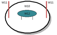
Currently, the main use in a router is a directional antenna. This is used to make the signal more hard because the direction of the signal is concentrated in the direction the antenna is pointing. However, to measure the direction, we are going to use an omnidirectional antenna because we have to send and receive signals from everywhere. If you change the directional antenna to an omnidirectional antenna, the signal strength and range of the existing router may be weakened. The direction is designed so that the center point of the antenna is held and the angle at which the signal enters is measured.
The present invention is a mobile terminal position measuring system through a wireless communication network for the above purpose, and constructs a sophisticated position measurement system that can reduce errors by utilizing GPS signals and wireless communication signals (3G, 4G) together.
In order to determine the location of the three-dimensional space, a Wi-Fi router distributed in various places is used as a measuring device to measure a position by receiving a wireless communication signal.
Attach an antenna to the WiFi router to measure the new value (angle) to reduce the influence of the interference on the measurement.
This reduces errors and allows more precise position measurements.
In addition, a virtual cloud server that can compute position information can be installed, and the information measured by the Wi-Fi router is collected using the IoT, transmitted to the virtual crowd server, and analyzed within the server. I will.
The effect of the present invention is that more accurate position measurement becomes possible and it is expected to result in an improved result of about 50% or more.
It is possible to obtain the spatial range information such as the number of layers of the building rather than the approximate position of the two-dimensional space.
Due to various environment variables, the location information that is being played is reduced and the location information is close to the actual location.
If the location measurement is correct, it will have an excellent effect not only on finding lost items, but also on survival when a safety accident or crime occurs. Also, since the range of application is wide, the versatility will be excellent.
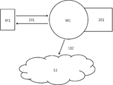
[Fig. 1] System structure for measuring position information through communication between M1 and W1 and sending it to S1
[Fig. 2] Cross-sectional view of a form in which W12 is attached to W1
[Fig. 3] Theory of a technique for measuring the position of an object in W1
The location measurement using the wireless communication network is performed through the Wi-Fi router.
To do so, an additional omnidirectional antenna is installed on the WiFi Router to measure the angle and add new variables to the position measurement.
Currently, the main use in a router is a directional antenna. This is used to make the signal more hard because the direction of the signal is concentrated in the direction the antenna is pointing. However, to measure the direction, we are going to use an omnidirectional antenna because we have to send and receive signals from everywhere. If you change the directional antenna to an omnidirectional antenna, the signal strength and range of the existing router may be weakened. The direction is designed so that the center point of the antenna is held and the angle at which the signal enters is measured.
Inside the Wi-Fi router, a system for receiving the wireless communication signal and measuring the position of the wireless communication device should be installed.
In this system, the distance between the mobile terminal and the Wi-Fi router is measured using the existing TDOA method, and a new measurement value is added to measure the position of the mobile terminal.
A virtual cloud server should be built to synthesize location information.
We construct a system that transmits location information by using IoT technology from Wi-Fi router to virtual cloud server.
There is only one router to which one terminal is connected. However, since signals can be exchanged and checked by all routers within the range, IoT technology is used to share location information of terminals measured through communication between routers. If you do so, you can get more detailed directions and location information.
In other words, TDOA is used in the existing technology to calculate the distance, and further measures the direction of the signal to find out which is located to enable detailed positioning.
This server stores and analyzes location information transmitted from everywhere. The information of the place where the most part matches is determined as the final position information by synthesizing the information sent from the Wi-Fi router in the vicinity of the terminal.
The determined value is transmitted to the user as the position value of the terminal.
While the present invention has been particularly shown and described with reference to exemplary embodiments thereof, it is clearly understood that the same is by way of illustration and example only and is not to be construed as limited to the embodiments set forth herein. Various changes and modifications may be made by those skilled in the art.
101
Wireless communication signal
102
Location information measurement
201
Location information
M1
Mobile terminal
S1
Virtual cloud server
W1
WiFi Router
W10
WiFi Router Body
W11
WiFi Router Directional Antenna
W12
WiFi Router Antenna Antenna
Claims (5)
(a) As a tool for transmitting and receiving Wi-Fi signals to establish a mobile terminal position measurement system over a wireless communication network,
(b) Two directional antennas attached to both ends to transmit and receive strong signals when transmitting and receiving wireless communication signals to establish a mobile terminal position measurement system over a wireless communication network,
(c) one center-mounted omni-directional antenna to measure the new variable (angle) value to establish a mobile terminal position measurement system over the wireless network
(a) The distance between the terminal and the router is measured using the conventional TDOA method.
(b) Measuring the angle between the terminal and the router through the omnidirectional antenna attached to the Wi-Fi router to establish a mobile terminal position measurement system over the wireless communication network
(a) Build a server using a virtual cloud to collect and analyze various information to build a mobile terminal location measurement system over a wireless communication network
(b) A system to transmit the location information collected from the Wi-Fi router to the virtual cloud server to establish a mobile terminal location measurement system over the wireless communication network
The position information is measured using the position measurement method of claim 2 in the Wi-Fi router designed in the claim 1.
And transmits the measured information from the Wi-Fi router to the virtual server constructed in the third paragraph.
Build and design systems using equipment and servers mentioned in the above claims.
Through the above system, mobile terminal location measurement system is constructed through wireless communication network which compares position measurement values collected from various places and obtains position information of matching points from information of WiFi routers located around the terminal.
Priority Applications (1)
| Application Number | Priority Date | Filing Date | Title |
|---|---|---|---|
| KR1020150081591A KR20160145263A (en) | 2015-06-10 | 2015-06-10 | A mobile positional system through the wireless communication network |
Applications Claiming Priority (1)
| Application Number | Priority Date | Filing Date | Title |
|---|---|---|---|
| KR1020150081591A KR20160145263A (en) | 2015-06-10 | 2015-06-10 | A mobile positional system through the wireless communication network |
Publications (1)
| Publication Number | Publication Date |
|---|---|
| KR20160145263A true KR20160145263A (en) | 2016-12-20 |
Family
ID=57734306
Family Applications (1)
| Application Number | Title | Priority Date | Filing Date |
|---|---|---|---|
| KR1020150081591A KR20160145263A (en) | 2015-06-10 | 2015-06-10 | A mobile positional system through the wireless communication network |
Country Status (1)
| Country | Link |
|---|---|
| KR (1) | KR20160145263A (en) |
Citations (4)
| Publication number | Priority date | Publication date | Assignee | Title |
|---|---|---|---|---|
| KR20080019593A (en) | 2005-06-28 | 2008-03-04 | 마이크로소프트 코포레이션 | Positi0ning service utilizing existing radi0 base stati0ns |
| US8472974B2 (en) | 2010-04-28 | 2013-06-25 | T-Mobile Usa, Inc. | Location continuity service for locating mobile devices using multiple access networks including wireless telecommunication networks |
| US20140274131A1 (en) | 2013-03-12 | 2014-09-18 | Qualcomm Incorporated | Methods and apparatus for enhanced network device location determinations |
| US8849314B2 (en) | 2009-04-29 | 2014-09-30 | Blackberry Limited | Systems and methods for location tracking notification |
-
2015
- 2015-06-10 KR KR1020150081591A patent/KR20160145263A/en unknown
Patent Citations (4)
| Publication number | Priority date | Publication date | Assignee | Title |
|---|---|---|---|---|
| KR20080019593A (en) | 2005-06-28 | 2008-03-04 | 마이크로소프트 코포레이션 | Positi0ning service utilizing existing radi0 base stati0ns |
| US8849314B2 (en) | 2009-04-29 | 2014-09-30 | Blackberry Limited | Systems and methods for location tracking notification |
| US8472974B2 (en) | 2010-04-28 | 2013-06-25 | T-Mobile Usa, Inc. | Location continuity service for locating mobile devices using multiple access networks including wireless telecommunication networks |
| US20140274131A1 (en) | 2013-03-12 | 2014-09-18 | Qualcomm Incorporated | Methods and apparatus for enhanced network device location determinations |
Similar Documents
| Publication | Publication Date | Title |
|---|---|---|
| Hepp et al. | Omni-directional person tracking on a flying robot using occlusion-robust ultra-wideband signals | |
| CN107431894A (en) | Method and apparatus for positioning mobile terminal in a radio network | |
| CN103997780A (en) | Method for localizing mobile terminal, and base station | |
| CN104185273A (en) | Anchor-node-free positioning method, system and device for distance measuring | |
| CN108141698A (en) | A kind of floor location method, equipment and system | |
| CN103476112A (en) | Mobile terminal positioning method and base station | |
| Syberfeldt et al. | Localizing operators in the smart factory: A review of existing techniques and systems | |
| Mrindoko et al. | A comparison review of indoor positioning techniques | |
| Weber et al. | Comparison of various methods for indoor RF fingerprinting using leaky feeder cable | |
| Gunnarsson et al. | Particle filtering for network-based positioning terrestrial radio networks | |
| Su et al. | A hybrid indoor-position mechanism based on bluetooth and WiFi communications for smart mobile devices | |
| Doiphode et al. | Survey of indoor positioning measurements, methods and techniques | |
| Domingo et al. | Indoor Positioning System Using Depth Maps and Wireless Networks. | |
| Danjo et al. | A theoretical error analysis on indoor TOA localization scheme using unmanned aerial vehicles | |
| Kuxdorf-Alkirata et al. | Reliable and low-cost indoor localization based on bluetooth low energy | |
| Duque Domingo et al. | Indoor positioning system using depth maps and wireless networks | |
| CN104459620B (en) | A kind of radio positioner and method | |
| Yassin et al. | Performance comparison of positioning techniques in Wi-Fi networks | |
| Madhan et al. | RSSI based location estimation in A Wi-Fi environment: An experimental study | |
| CN105657820A (en) | Method and device for locating indoor target user equipment | |
| KR20160145263A (en) | A mobile positional system through the wireless communication network | |
| Lowrance et al. | Direction of arrival estimation for robots using radio signal strength and mobility | |
| Fokin et al. | Model for 5G UDN Positioning System Topology Search Using Dilution of Precision Criterion | |
| Fokin et al. | Topology Search Using Dilution of Precision Criterion for Enhanced 5G Positioning Service Area | |
| Weber et al. | Wireless indoor positioning: Localization improvements with a leaky coaxial cable prototype |