JP2007155461A - Navigation apparatus - Google Patents
Navigation apparatus Download PDFInfo
- Publication number
- JP2007155461A JP2007155461A JP2005349981A JP2005349981A JP2007155461A JP 2007155461 A JP2007155461 A JP 2007155461A JP 2005349981 A JP2005349981 A JP 2005349981A JP 2005349981 A JP2005349981 A JP 2005349981A JP 2007155461 A JP2007155461 A JP 2007155461A
- Authority
- JP
- Japan
- Prior art keywords
- point
- road
- guidance
- guide
- branch point
- Prior art date
- Legal status (The legal status is an assumption and is not a legal conclusion. Google has not performed a legal analysis and makes no representation as to the accuracy of the status listed.)
- Granted
Links
Images


Landscapes
- Navigation (AREA)
- Traffic Control Systems (AREA)
- Instructional Devices (AREA)
Abstract
Description
本発明は、利用者に対して案内標識を用いることによって分岐点での走行の案内を行うナビゲーション装置に関し、特に、所定地点への探索経路で自車が現在走行する道路から他の道路へと進入する進入分岐点において、探索された所定地点に関する案内標識を作成することによって、分岐点での案内に係る利便性を向上させたナビゲーション装置に関するものである。 The present invention relates to a navigation device that guides a user to travel at a branch point by using a guide sign, and in particular, from a road on which the vehicle currently travels on a search route to a predetermined point to another road. The present invention relates to a navigation device that improves the convenience of guidance at a branch point by creating a guide sign related to the searched predetermined point at the approach branch point to enter.
近年、車両の走行案内を行い、運転者が所望の目的地に容易に到着できるようにしたナビゲーション装置が車両に搭載されていることが多い。ここで、ナビゲーション装置とは、GPS受信機などにより自車の現在位置を検出し、その現在位置に対応する地図データをDVD−ROMやHDDなどの記録媒体またはネットワークを通じて取得して液晶モニタに表示することが可能な装置である。更に、かかるナビゲーション装置には、所望する目的地を入力すると、自車位置から目的地までの最適経路を探索する経路探索機能を備えており、ディスプレイ画面に誘導経路を表示するとともに、交差点に接近した場合等には音声による案内をすることによって、運転者を所望の目的地まで確実に案内するようになっている。 2. Description of the Related Art In recent years, a navigation device is often mounted on a vehicle that provides vehicle travel guidance so that a driver can easily arrive at a desired destination. Here, the navigation device detects the current position of the vehicle by a GPS receiver or the like, acquires map data corresponding to the current position through a recording medium such as a DVD-ROM or HDD or a network, and displays it on a liquid crystal monitor. It is a device that can do. Furthermore, such a navigation device has a route search function for searching for the optimum route from the vehicle position to the destination when a desired destination is input, and displays the guidance route on the display screen and approaches the intersection. In such a case, the driver is surely guided to a desired destination by providing voice guidance.
また、従来のナビゲーション装置には、自車の走行中において交差点等の分岐点に付近に到達すると、分岐可能な各方面の地名が表示された方面案内看板をディスプレイに表示するものがある(例えば、特開2001−311625号公報)。そして、運転者は表示された方面案内看板を参照することにより、道路上に設置された方面案内看板が視認できない環境下においても、特定の分岐路で進むべき方向を自ら認識することが可能となる。
しかしながら、前記した特許文献1に記載されたナビゲーション装置では、予め決められた交差点等の分岐点を走行する際に、その分岐点で案内する各方面の代表的な地名のみを方面案内看板で表示していた。従って、予め決められた分岐点を通過した後には、利用者が方面案内板に表示されていた方面への走行を希望したとしても、その後の分岐点で同一方面を案内した方面案内看板の表示が再び行われるとは限らなかった。また、方面案内看板に表示された代表的な地名を知らない利用者は、方面案内看板を参照しても表示された各方面がどこへ向かうのかを理解することができなかった。
このように、予め決められたタイミングで決められた内容の看板を表示するのみでは、一部の利用者に対しては有効であるものの、特に地名に詳しくない利用者や運転に慣れていない利用者に対しては、十分な案内が行われているとは言い難かった。
However, in the navigation device described in
In this way, it is effective for some users to display a signboard with predetermined content at a predetermined timing, but users who are not familiar with the place name or are not familiar with driving It was hard to say that there was sufficient guidance for the person.
本発明は前記従来における問題点を解消するためになされたものであり、予め定められた分岐点や代表的な地名に限られることなく、利用者にとって分岐点で案内する各方面を理解しやすい案内標識を作成することが可能となり、分岐点での案内に係る利便性を向上させたナビゲーション装置に関するものである。 The present invention has been made to solve the above-described conventional problems, and is not limited to a predetermined branch point or a representative place name, and it is easy for the user to understand each direction guided at the branch point. The present invention relates to a navigation device that can create a guide sign and has improved convenience related to guidance at a branch point.
前記目的を達成するため本願の請求項1に係るナビゲーション装置(1)は、自車の現在走行する走行道路を検出する走行道路検出手段(11、13)と、所定地点(64、65)までの経路を探索する経路探索手段(13)と、前記経路探索手段によって探索された探索経路が前記走行道路から他の道路へと進入する進入分岐点(70、71)を検出する分岐点検出手段(13)と、前記分岐点検出手段によって検出された進入分岐点での前記所定地点に関する案内標識(81、91、101、111)を作成する案内標識作成手段(13)と、を有することを特徴とする。
ここで、「案内標識」とは車両の走行を案内する為の標識の一つであって、分岐点において分岐する経路が案内する各方面をそれぞれ文字や図形等によって示した標識である。
また、「分岐点」とは3本以上のリンクが接続されているノードが該当し、インターチェンジや交差点等が該当する。
In order to achieve the above object, the navigation device (1) according to
Here, the “guidance sign” is one of signs for guiding the traveling of the vehicle, and is a sign indicating each direction guided by the route branched at the branch point by characters, figures, or the like.
A “branch point” corresponds to a node to which three or more links are connected, such as an interchange or an intersection.
また、請求項2に係るナビゲーション装置(1)は、請求項1に記載のナビゲーション装置であって、自車の現在位置を検出する自車位置検出手段(11)と、前記案内標識作成手段(13)によって作成された案内標識(81、91、101、111)を表示する案内標識表示手段(15)と、を有し、前記案内標識表示手段は、自車が前記進入分岐点(70、71)の所定距離手前を走行するタイミングで前記案内標識を表示することを特徴とする。
A navigation device (1) according to claim 2 is the navigation device according to
また、請求項3に係るナビゲーション装置(1)は、請求項1又は請求項2に記載のナビゲーション装置であって、前記進入分岐点(70、71)は前記経路探索手段(13)によって探索された探索経路(68、69)が前記走行道路へと戻らずに前記所定地点(64、65)へと到達する分岐点であることを特徴とする。
The navigation device (1) according to claim 3 is the navigation device according to
また、請求項4に係るナビゲーション装置(1)は、請求項1乃至請求項3のいずれかに記載のナビゲーション装置であって、自車の現在走行する走行道路(62)が高規格道路であるか否かを判定する高規格道路判定手段(13)を有し、前記案内標識作成手段(13)は前記高規格道路判定手段によって高規格道路であると判定された場合に案内標識(81、91、101、111)を作成することを特徴とする。
A navigation device (1) according to claim 4 is the navigation device according to any one of
更に、請求項5に係るナビゲーション装置(1)は、請求項1乃至請求項4のいずれかに記載のナビゲーション装置であって、前記案内標識(81、91、101、111)は前記進入分岐点(70、71)において前記所定地点(64、65)へと向かう他の道路の案内に対して所定地点を連想させる図形(83、93、103、113)を示すことを特徴とする。
Further, the navigation device (1) according to
前記構成を有する請求項1に係るナビゲーション装置では、所定地点までの探索経路が自車の走行する走行道路から他の道路へと進入する進入分岐点における所定地点に関する案内標識を作成するので、予め定められた分岐点や代表的な地名に限られることなく、利用者にとって分岐点で案内する各方面を示した理解しやすい案内標識を作成することが可能となる。従って、特に地名に詳しくない利用者や、運転に慣れていない利用者に対しても十分な案内を提供することができる。
In the navigation device according to
また、請求項2に係るナビゲーション装置では、所定地点までの探索経路が自車の走行する走行道路から他の道路へと進入する進入分岐点における所定地点に関する案内標識を作成し、分岐点の所定距離手前で作成した案内標識を表示するので、利用者にとって分岐点で案内する各方面を示した理解しやすい案内標識を表示することが可能となる。従って、特に地名に詳しくない利用者や、運転に慣れていない利用者に対しても十分な案内を提供することができる。 Further, in the navigation device according to claim 2, a guide sign relating to a predetermined point at an approach branch point where the search route to the predetermined point enters from the traveling road on which the vehicle travels to another road is created, and a predetermined branch point is determined. Since the guide sign created before the distance is displayed, it becomes possible for the user to display easy-to-understand guide signs showing the directions to be guided at the branch points. Therefore, sufficient guidance can be provided even for users who are not familiar with the place name or who are not familiar with driving.
また、請求項3に係るナビゲーション装置では、所定地点までの探索経路が自車の走行する走行道路へと戻らずに所定地点へと到達する分岐点における所定地点に関する案内標識を作成するので、所定地点へと走行する為に右折又は左折する最適な分岐点で所定地点を案内した理解しやすい案内標識を作成することが可能となる。従って、特に地名に詳しくない利用者や、運転に慣れていない利用者に対しても十分な案内を提供することができる。 Further, in the navigation device according to claim 3, since the search route to the predetermined point does not return to the traveling road on which the vehicle travels, the guide sign for the predetermined point at the branch point that reaches the predetermined point is created. It is possible to create an easy-to-understand guide sign that guides a predetermined point at an optimal branch point for turning right or left to travel to the point. Therefore, sufficient guidance can be provided even for users who are not familiar with the place name or who are not familiar with driving.
また、請求項4に係るナビゲーション装置では、自車の走行する道路が高規格道路であると判定された場合に案内標識を作成するので、利用者にとって必要とされる主要な道路を走行している状況での案内に係る利便性を確保しつつ、案内標識の作成に係る処理負担を軽減することが可能となる。 Further, in the navigation device according to claim 4, a guide sign is created when it is determined that the road on which the vehicle is traveling is a high-standard road. It is possible to reduce the processing burden related to the creation of the guide sign while ensuring the convenience related to the guide in the situation where the user is present.
更に、請求項5に係るナビゲーション装置では、案内標識は進入分岐点において所定地点へと向かう他の道路の案内に対して所定地点を連想させる図形を示すので、走行中であっても利用者が案内標識の内容を容易に把握することが可能となる。 Furthermore, in the navigation device according to the fifth aspect, the guide sign shows a figure reminiscent of the predetermined point for the guidance of another road heading to the predetermined point at the approach branch point. It becomes possible to easily grasp the contents of the guide sign.
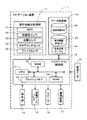
以下、本発明に係るナビゲーション装置について具体化した一実施形態に基づき図面を参照しつつ詳細に説明する。先ず、本実施形態に係るナビゲーション装置1の概略構成について図1を用いて説明する。図1は本実施形態に係るナビゲーション装置1を示したブロック図である。
DETAILED DESCRIPTION Hereinafter, a navigation device according to the present invention will be described in detail with reference to the drawings based on a specific embodiment. First, a schematic configuration of the
図1に示すように本実施形態に係るナビゲーション装置1は、自車の現在位置を検出する現在地検出処理部(自車位置検出手段)11と、各種のデータが記録されたデータ記録部12と、入力された情報に基づいて、各種の演算処理を行うナビゲーション制御部(走行道路検出手段、経路探索手段、分岐点検出手段、案内標識作成手段、高規格道路判定手段)13と、操作者からの操作を受け付ける操作部14と、操作者に対して地図等の情報を表示する液晶ディスプレイ(案内標識表示手段)15と、経路案内に関する音声ガイダンスを出力するスピーカ16と、交通情報センタ等の情報センタとの間で通信を行う通信装置17と、から構成されている。また、ナビゲーション制御部13には自車の走行速度を検出する車速センサ21が接続される。
As shown in FIG. 1, the
以下に、ナビゲーション装置1を構成する各構成要素について説明すると、現在地検出処理部11は、GPS31、地磁気センサ32、距離センサ33、ステアリングセンサ34、方位検出部としてのジャイロセンサ35、高度計(図示せず)等からなり、現在の自車の位置、方位、目標物(例えば、交差点)までの距離等を検出することが可能となっている。
The components constituting the
具体的には、GPS31は、人工衛星によって発生させられた電波を受信することにより、地球上における自車の現在地及び現在時刻を検出し、地磁気センサ32は、地磁気を測定することによって自車方位を検出し、距離センサ33は、道路上の所定の位置間の距離等を検出する。ここで、距離センサ33としては、例えば、自車の車輪(図示せず)の回転速度を測定し、測定した回転速度に基づいて距離を検出するセンサ、加速度を測定し、測定した加速度を2回積分して距離を検出するセンサ等を使用することができる。
Specifically, the
また、ステアリングセンサ34は自車の舵(だ)角を検出する。ここで、ステアリングセンサ34としては、例えば、ステアリングホイール(図示せず)の回転部に取り付けられた光学的な回転センサ、回転抵抗センサ、車輪に取り付けられた角度センサ等が使用される。
The
そして、ジャイロセンサ35は自車の旋回角を検出する。ここで、ジャイロセンサ35としては、例えば、ガスレートジャイロ、振動ジャイロ等が使用される。また、ジャイロセンサ35によって検出された旋回角を積分することにより、自車方位を検出することができる。
And the
また、データ記録部12は、外部記憶装置及び記録媒体としてのハードディスク(図示せず)と、ハードディスクに記録された地図情報DB22、案内標識素材DB23、地点記憶テーブル24、所定のプログラム等を読み出すとともにハードディスクに所定のデータを書き込む為のドライバである記録ヘッド(図示せず)とを備えている。尚、本実施形態においては、データ記録部12の外部記憶装置及び記憶媒体としてハードディスクが使用されるが、ハードディスクのほかに、フレキシブルディスク等の磁気ディスクを外部記憶装置として使用することができる。また、メモリーカード、磁気テープ、磁気ドラム、CD、MD、DVD、光ディスク、MO、ICカード、光カード等を外部記憶装置として使用することもできる。尚、地図情報DB22、案内標識素材DB23、地点記憶テーブル24の詳細については後述する。
The
更に、ナビゲーション制御部13は、ナビゲーション装置1の全体の制御を行う演算装置及び制御装置としてのCPU41、並びにCPU41が各種の演算処理を行うに当たってワーキングメモリとして使用されるとともに、経路が探索されたときの経路データ等が記憶されるRAM42、制御用のプログラムのほか、分岐点での方面案内に使用する案内標識を作成し、作成した案内標識を所定のタイミングで利用者に対して表示する案内標識表示処理プログラム(図4参照)が記録されたROM43、ROM43から読み出したプログラムを記録するフラッシュメモリ44等の内部記憶装置を備えている。尚、前記RAM42、ROM43、フラッシュメモリ44等としては半導体メモリ、磁気コア等が使用される。そして、演算装置及び制御装置としては、CPU41に代えてMPU等を使用することも可能である。
Furthermore, the
また、本実施形態においては、前記ROM43に各種のプログラムが記録され、前記データ記録部12に各種のデータが記録されるようになっているが、プログラム、データ等を同じ外部記憶装置、メモリーカード等からプログラム、データ等を読み出して前記フラッシュメモリ44に書き込むこともできる。更に、メモリーカード等を交換することによって前記プログラム、データ等を更新することができる。
In the present embodiment, various programs are recorded in the
更に、前記ナビゲーション制御部13には、操作部14、液晶ディスプレイ15、スピーカ16、通信装置17の各周辺装置(アクチュエータ)が電気的に接続されている。
Furthermore, the
操作部14は、走行開始時の現在地を修正し、案内開始地点としての出発地及び案内終了地点としての目的地を入力する際等に操作され、各種のキー、ボタン等の複数の操作スイッチ(図示せず)から構成される。そして、ナビゲーション制御部13は、各スイッチの押下等により出力されるスイッチ信号に基づき、対応する各種の動作を実行すべく制御を行う。尚、操作部14としては、キーボード、マウス、バーコードリーダ、遠隔操作用のリモートコントロール装置、ジョイスティック、ライトペン、スタイラスペン等を使用することもできる。更に、液晶ディスプレイ15の前面に設けたタッチパネルによって構成することもできる。
The
また、液晶ディスプレイ15には、操作案内、操作メニュー、キーの案内、現在地から目的地までの誘導経路、誘導経路に沿った案内情報、交通情報、ニュース、天気予報、時刻、メール、テレビ番組等が表示される。更に、本実施形態に係るナビゲーション装置1では、分岐点の所定距離手前を走行する際に分岐点の各方面を案内する案内標識(図7〜図10参照)が表示される。尚、液晶ディスプレイ15の代わりに、CRTディスプレイ、プラズマディスプレイ等を使用したり、車両のフロントガラスにホログラムを投影するホログラム装置等を使用することも可能である。
The
また、スピーカ16は、ナビゲーション制御部13からの指示に基づいて誘導経路に沿った走行を案内する音声ガイダンスを出力する。ここで、案内される音声ガイダンスとしては、例えば、「200m先の交差点を右折してください。」や「この先の国道○○号線が渋滞しています。」等がある。なお、スピーカ16より出力される音声としては、合成された音声のほかに、各種効果音、予めテープやメモリ等に録音された各種の案内情報を出力することもできる。
In addition, the
そして、通信装置17は、交通情報センタ、例えば、VICS(登録商標:Vehicle Information and Communication System)センタ等から送信された渋滞情報、規制情報、駐車場情報、交通事故情報等の各情報から成る交通情報を、道路に沿って配設された電波ビーコン装置、光ビーコン装置等を介して電波ビーコン、光ビーコン等として受信するビーコンレシーバである。また、通信装置17としては、LAN、WAN、イントラネット、携帯電話回線網、電話回線網、公衆通信回線網、専用通信回線網、インターネット等の通信回線網等の通信系において通信を可能とするネットワーク機器であっても良い。更に、通信装置17は前記情報センタからの情報の他に、ニュース、天気予報等の情報から成るFM多重情報を、FM放送局を介してFM多重放送として受信するFM受信機を備える。尚、前記ビーコンレシーバ及びFM受信機は、ユニット化されてVICSレシーバとして配設されるようになっているが、別々に配設することもできる。
The
次に、データ記録部12に格納された地図情報DB22について説明する。ここで、地図情報DB22には、経路案内及び地図表示に必要な地図データが記録されており、地図データは、例えば地図を表示するための地図表示データ、各交差点に関する交差点データ、道路(リンク)に関するリンクデータ、ノード点に関するノードデータ、経路を探索するための探索データ、施設に関する施設データ、地点を検索するための検索データ等から構成されている。
Next, the
ここで、特にリンクデータとしては、道路を構成する各リンクに関してリンクの属する道路の幅員、勾(こう)配、カント、バンク、路面の状態、道路の車線数、車線数の減少する箇所、幅員の狭くなる箇所、踏切り等を表すデータが、コーナに関して、曲率半径、交差点、T字路、コーナの入口及び出口等を表すデータが、道路属性に関して、降坂路、登坂路等を表すデータが、道路種別に関して、国道、県道、細街路等の一般道のほか、高速自動車国道、自動車専用道路、都市高速道路、一般有料道路、有料橋等の有料道路を表すデータがそれぞれ記録される。更に、有料道路に関して、有料道路の入口及び出口の取付道(ランプウェイ)、料金所(インターチェンジ)等に関するデータが記録される。 In particular, the link data includes the width of the road to which the link belongs, the gradient, the cant, the bank, the road surface condition, the number of road lanes, the number of lanes that decrease, and the width. The data representing the narrowing part, the railroad crossing, etc., the data regarding the corner, the curvature radius, the intersection, the T-junction, the entrance and the exit of the corner, the data indicating the downhill road, the uphill road, etc. regarding the road attribute, Regarding road types, in addition to general roads such as national roads, prefectural roads and narrow streets, data representing toll roads such as highway automobile national roads, automobile exclusive roads, city expressways, general toll roads, and toll bridges are recorded. Furthermore, regarding toll roads, data relating to entrance roads (rampways), toll gates (interchanges) and the like of toll roads are recorded.
また、ノードデータとしては、道路の分岐点(交差点、T字路等も含む)、各道路に曲率半径等に応じて所定の距離ごとに設定されたノード点の座標(位置)、ノードが交差点に対応するノードであるか等を表すノード属性、ノードに接続するリンクのリンク番号のリストである接続リンク番号リスト、ノードにリンクを介して隣接するノードのノード番号のリストである隣接ノード番号リスト、各ノード点の高さ(高度)等に関するデータ等が記録される。 The node data includes road branch points (including intersections and T-junctions), node point coordinates (positions) set for each road according to the radius of curvature, etc., and nodes at intersections. A node attribute indicating whether the node corresponds to the node, a connection link number list which is a list of link numbers of links connected to the node, an adjacent node number list which is a list of node numbers of nodes adjacent to the node via the link Data relating to the height (altitude) of each node point is recorded.
また、探索データとしては、設定された目的地までの経路を探索及び表示する際に使用されるデータについて記録されており、ノードを通過する際のコスト(以下、ノードコストという)や道路を構成するリンクのコスト(以下、リンクコストという)からなる探索コストを算出する為に使用するコストデータ、リンクを通過するのに必要な旅行時間、経路探索により選択された経路を液晶ディスプレイ15の地図上に表示するための経路表示データ等から構成されている。
ここで、ノードコストは交差点に対応するノードに対して基本的に設定されており、本実施形態に係るナビゲーション装置1では、信号の有無や交差点を通過する際の自車の走行経路(即ち直進、右折及び左折の種類)によってその値が決定される。
また、リンクコストは、リンクを構成する道路属性や道路種別、道路幅、車線数、リンク長さ等に関するデータを用いて算出される。
In addition, as search data, data used for searching and displaying a route to a set destination is recorded, and costs for passing through a node (hereinafter referred to as node cost) and roads are configured. The cost data used to calculate the search cost consisting of the cost of the link to be performed (hereinafter referred to as the link cost), the travel time required to pass the link, and the route selected by the route search are displayed on the map of the
Here, the node cost is basically set for the node corresponding to the intersection, and in the
The link cost is calculated using data relating to road attributes, road types, road widths, the number of lanes, link lengths, and the like constituting the links.
また、施設データとしては、各地域のホテル、病院、ガソリンスタンド、駐車場、観光施設、インターチェンジ、レストラン、サービスエリア等の建物に関するデータが建物を特定する施設IDとともに記録される。なお、前記地図情報DB22には、所定の情報をナビゲーション装置1のスピーカ16によって出力するための音声出力データも記録される。
In addition, as facility data, data related to buildings such as hotels, hospitals, gas stations, parking lots, tourist facilities, interchanges, restaurants, service areas, and the like in each region are recorded together with facility IDs that identify the buildings. The
ここで、本実施形態に係るナビゲーション装置1において、経路を探索するに当たっては、出発地側及び目的地側から地図データのリンク及びノードに沿って経路の探索が行われ、出発地側からの探索と目的地側からの探索との重なり部分において、出発地側から累積された探索コスト(ノードコスト及びリンクコスト)と目的地側から累積された探索コストとを加算した値、即ち、コスト加算値が算出されるようになっている。そして、コスト加算値が最小になる経路が誘導経路として設定される。
Here, in the
また、これら地図情報DB22の内容は、DVDや外部に接続したメモリーカード等の記録媒体から情報を転送すること、又は特定の情報センタ等から通信装置17を介して情報をダウンロードすること等によって更新される。
The contents of the
次に、データ記録部12に格納された案内標識素材DB23について図2を用いて説明する。図2は本実施形態に係る案内標識素材DB23の記憶領域を示した模式図である。ここで、案内標識素材DB23は、後述する分岐点での案内標識を作成するために用いられる各種画像及び文字データについて記憶されている。
具体的には、分岐点での方面を示す複数種類の矢印に係る画像が記憶された矢印画像データ51と、分岐点で案内する各案内地点に関する写真、地図、図形等に係る画像が記憶された案内地点画像データ52と、案内地点を通る代表的な道路番号(国道番号、都道府県番号、交差道路番号等)の図形に係る画像が記憶された道路番号画像データ53と、分岐点で案内する案内地点の地名に関する文字が記憶された地名文字データ54によって構成されている。また、矢印画像データ51に記憶された矢印の画像データは、地図情報DB22に記憶された一又は複数の分岐点に関連付けられており、案内地点画像データ52、道路番号画像データ53及び地名文字データ54に記憶された各文字データ及び画像データは、地点記憶テーブル24に記憶された一又は複数の案内地点に対して関連付けられている。
尚、案内地点とは自宅、予め利用者によって登録された登録地点、県庁所在地、市町村代表点、自車が過去に通過した地点、過去に目的地に設定された地点、過去に検索された地点等が該当し、後述する地点記憶テーブル24に記憶される。
Next, the guide
Specifically,
In addition, the guide point is the home, the registered point registered in advance by the user, the prefectural office location, the municipality representative point, the point where the vehicle has passed in the past, the point set as the destination in the past, the point searched in the past And the like are stored in the point storage table 24 described later.
そして、本実施形態に係るナビゲーション装置1では、後述するように自車が走行する道路から案内地点へ走行する為に進入する必要のある他の道路へと分岐する分岐点に関する案内標識を、案内標識素材DB23に記憶された矢印画像データ51、案内地点画像データ52、道路番号画像データ53及び地名文字データ54の内、分岐点や案内地点に関連付けられたデータを用いて作成して液晶ディスプレイ15に表示する(図4のS8〜S11)。
And in the
続いて、データ記録部12に格納される地点記憶テーブル24について図3を用いて説明する。図3は本実施形態に係る地点記憶テーブル24の一例について示した図である。ここで、地点記憶テーブル24はナビゲーション装置1が案内標識を作成する際の案内地点となる自宅、利用者によって登録された登録地点、県庁所在地、市町村代表点、自車が過去に通過した地点、過去に目的地に設定された地点、過去に検索された地点等を記憶したテーブルである。
Next, the point storage table 24 stored in the
図3に示すように、本実施形態に係る地点記憶テーブル24は、案内地点の種類と案内地点の名称と案内地点の位置座標とから構成されている。
例えば、図3に示す地点記憶テーブル24では「自宅」が座標(x01,y01)に位置する案内地点として記憶されている。また、登録地点である「××ランド」が座標(x02,y02)に位置する案内地点として記憶されている。
As illustrated in FIG. 3, the point storage table 24 according to the present embodiment includes a type of guidance point, a name of the guidance point, and position coordinates of the guidance point.
For example, in the point storage table 24 shown in FIG. 3, “home” is stored as a guide point located at the coordinates (x01, y01). Further, “XX land” which is a registered point is stored as a guide point located at the coordinates (x02, y02).
そして、これらの案内地点に関する情報の内、特に「自宅」及び「登録地点」に関する情報は利用者が操作部14を用いて住所や施設名称を入力することにより記憶される。また、「県庁所在地」及び「市町村代表点」に関する情報はナビゲーション装置1の出荷時において予め記憶されている。また、「自車が過去に通過した地点」については自車の走行履歴に基づいて自動的に記憶される。更に、「過去に目的地に設定された地点」及び「過去に検索された地点」については、利用者による経路の探索操作及び施設の検索操作を行った際に、目的地に設定した地点と検索を行った地点とがそれぞれ自動的に記憶される。
Of the information on the guide points, information on “home” and “registered point” is stored when the user inputs an address and facility name using the
続いて、前記構成を有するナビゲーション装置1においてCPU41が実行する案内標識表示処理プログラムについて図4に基づき説明する。図4は本実施形態に係る案内標識表示処理プログラムのフローチャートである。ここで、案内標識表示処理プログラムは車両のイグニションがONされた後に所定間隔(例えば4ms毎)で実行され、分岐点での方面案内に使用する案内標識を作成し、作成した案内標識を所定のタイミングで利用者に対して表示するプログラムである。尚、以下の図4にフローチャートで示されるプログラムは、ナビゲーション装置1が備えているRAM42やROM43に記憶されており、CPU41により実行される。
Next, a guide sign display processing program executed by the
先ず、案内標識表示処理プログラムではステップ(以下、Sと略記する)1において、CPU41はGPS11による自車の現在位置の検出結果と地図情報DB22に記憶されたリンクデータに基づいて、自車の現在走行する道路の種別と位置座標を検出する。尚、上記S1の処理が走行道路検出手段の処理に相当する。
First, in step (hereinafter abbreviated as S) 1 in the guidance sign display processing program, the
次に、S2では前記S1で検出された自車の現在走行道路が高規格道路(高速道路、国道、県道)であるか否かを判定する。そして、高規格道路であると判定された場合(S2:YES)にはS3へと移行する。
一方、高規格道路でないと判定された場合(S2:NO)、即ち自車の現在走行道路が細街路等の国道及び県道以外の一般道であると判定された場合には、案内標識を表示する必要のある道路でないと判断して当該案内標識表示処理プログラムを終了する。尚、上記S2の処理が高規格道路判定手段の処理に相当する。
Next, in S2, it is determined whether or not the current traveling road of the own vehicle detected in S1 is a high standard road (highway, national road, prefectural road). And when it determines with it being a high standard road (S2: YES), it transfers to S3.
On the other hand, if it is determined that the road is not a high standard road (S2: NO), that is, if it is determined that the current driving road of the vehicle is a general road other than a national road and a prefectural road such as a narrow street, a guidance sign is displayed. If it is determined that the road is not necessary, the information sign display processing program is terminated. The process of S2 corresponds to the process of the high standard road determination means.
次に、S3では地点記憶テーブル24に記憶された各案内地点の位置座標を読み出す。そして、S4において、自車位置の前方の所定探索エリア内に前記S3で読み出した案内地点の位置座標が含まれているか否かを判定する。 Next, in S3, the position coordinates of each guide point stored in the point storage table 24 are read out. In S4, it is determined whether or not the position coordinates of the guidance point read out in S3 are included in a predetermined search area in front of the vehicle position.
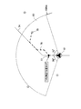
ここで、前記S4の案内地点の判定処理について図5を用いて詳細に説明する。図5は所定の道路を走行する自車と地点記憶テーブル24に記憶された各案内地点の位置関係を示した模式図である。
図5では、自車61が所定の道路62を走行する例を示しており、探索エリア63は図5に示すように、自車を中心とした半径10km以内のエリアであって、且つ自車の進行方向を中心とした中心角が150度の扇形エリアに設定される。
そして、前記S4で案内地点64〜67の位置座標が抽出された場合には、案内地点64、65が探索エリア63内に含まれると判定される。
Here, the guidance point determination process in S4 will be described in detail with reference to FIG. FIG. 5 is a schematic diagram showing the positional relationship between the own vehicle traveling on a predetermined road and each guide point stored in the point storage table 24.
FIG. 5 shows an example in which the
When the position coordinates of the guide points 64 to 67 are extracted in S4, it is determined that the guide points 64 and 65 are included in the
ここで、前記S4の判定の結果、案内地点が探索エリア内に一つも含まれていないと判定された場合(S4:NO)には、案内すべき案内地点が存在しないので案内標識の作成を行うことなく当該当該案内標識表示処理プログラムを終了する。
一方、少なくとも一以上の案内地点が探索エリア内に含まれていると判定された場合(S4:YES)には、S5へと移行する。
Here, as a result of the determination in S4, if it is determined that no guidance point is included in the search area (S4: NO), there is no guidance point to be guided, so a guide sign is created. The said guidance sign display processing program is complete | finished without performing.
On the other hand, when it is determined that at least one or more guide points are included in the search area (S4: YES), the process proceeds to S5.
続いて、S5では自車の現在位置から前記S4で探索エリア内に含まれると判定された各案内地点への経路の探索処理を行う。経路の探索処理では、地図データにおける探索データ中の道路データを調査して、探索に使用される道路(リンク及びノード)についての探索コスト(ノードコスト及びリンクコスト)を計算する。その後、現在位置側からの探索と案内地点側からの探索との重なり部分において、現在位置側から累積された探索コストと案内地点側から累積された探索コストとを加算した値、即ち、コスト加算値を算出し、最もコスト加算値が小さくなる経路を探索経路として案内地点毎に選択する。尚、上記S5の処理が経路探索手段の処理に相当する。 Subsequently, in S5, a route search process from the current position of the vehicle to each guide point determined to be included in the search area in S4 is performed. In the route search process, the road data in the search data in the map data is examined, and the search cost (node cost and link cost) for the road (link and node) used for the search is calculated. Then, in the overlapping part of the search from the current position side and the search from the guide point side, the value obtained by adding the search cost accumulated from the current position side and the search cost accumulated from the guide point side, that is, the cost addition A value is calculated, and a route with the smallest cost addition value is selected as a searched route for each guide point. The process of S5 corresponds to the process of the route search means.
次に、S6では前記S5で探索された案内地点までの探索経路が自車の現在走行する道路に戻る経路であるか否かを判定する。
例えば、図5に示すように、案内地点64、65まで経路を探索した結果、探索経路68、69のように自車61の走行する道路62に戻らない経路が探索された場合には、前記S5で探索された案内地点までの探索経路が自車の現在走行する道路に戻らない経路であると判定され、後述するように分岐点70、71に係る案内標識がそれぞれ作成される。
一方、図6に示すように、探索エリア63内に位置する案内地点75まで経路を探索した結果、探索経路76のように自車61の走行する道路62に再び戻る経路が探索された場合には、前記S5で探索された案内地点までの探索経路が自車の現在走行する道路に戻る経路であると判定され、分岐点77に係る案内標識は作成されない。
Next, in S6, it is determined whether or not the searched route to the guidance point searched in S5 is a route that returns to the road on which the vehicle is currently traveling.
For example, as shown in FIG. 5, when a route that does not return to the
On the other hand, as shown in FIG. 6, when a route to the
そして、前記S6で案内地点までの探索経路が自車の現在走行する道路に戻らない経路であると判定された場合(S6:YES)には、S7へと移行する一方、自車の現在走行する道路に戻る経路であると判定された場合(S6:NO)には、当該案内標識表示処理プログラムを終了する。 If it is determined in S6 that the search route to the guidance point is a route that does not return to the road on which the vehicle is currently traveling (S6: YES), the process proceeds to S7, while the vehicle is currently traveling. If it is determined that the route returns to the road to be performed (S6: NO), the guidance sign display processing program is terminated.
S7においては、前記S5によって探索された探索経路が自車の走行する道路から他の走路へと進入する分岐点(以下、進入分岐点という)を検出する。例えば、図5に示すように自車61が道路62を走行する場合には、案内地点64への探索経路68へと進入する分岐点70と、案内地点65への探索経路69へと進入する分岐点71とが進入分岐点としてそれぞれ検出される。尚、上記S7の処理が分岐点検出手段の処理に相当する。
In S7, a branch point (hereinafter referred to as an approach branch point) where the searched route searched in S5 enters from the road on which the vehicle travels to another road is detected. For example, as shown in FIG. 5, when the
続いて、S8では前記S7で検出された進入分岐点(図5では分岐点70、71)で案内する各案内地点(図5では案内地点64、65)に関連する文字や画像データを案内標識素材DB23から抽出する。
具体的には、先ず進入分岐点の分岐の種類(例えば、直進と右折に分岐する分岐点、直進と左折に分岐する分岐点、直進と右折と左折に分岐する分岐点など)を地図情報DB22から読み出して、分岐の種類に応じた矢印の画像を矢印画像データ51から抽出する。また、進入分岐点で案内する各案内地点に対して予め関連付けられた写真、地図、図形等の画像データや地名等の文字データを案内地点画像データ52、道路番号画像データ53、及び地名文字データ54から抽出する(図2参照)。
Subsequently, in S8, characters and image data related to each guidance point (guidance points 64 and 65 in FIG. 5) to be guided at the approach branch point (branch points 70 and 71 in FIG. 5) detected in S7 are guided signs. Extracted from the
Specifically, first, the
そして、S9では前記S8で抽出された文字データ及び画像データを用いて案内標識を作成する。ここで、図7乃至図10は前記S9で作成される案内標識の例を示した図である。
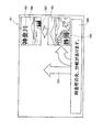
図7では進入分岐点において案内する案内地点が利用者の自宅である場合に作成される案内標識81の例を示す。図7に示すように、案内標識81は、分岐点で直進及び右折が可能であることを示す矢印82と、自宅を連想させる図形83と、「自宅」の文字84と、進入分岐点の位置を報知する案内文85とから構成されている。
そして利用者は案内標識81を参照することによって、料金所の先にある分岐を右折すると、自宅へと向かうことを容易に把握することが可能となる。
In S9, a guide sign is created using the character data and image data extracted in S8. Here, FIG. 7 to FIG. 10 are diagrams showing examples of guide signs created in S9.
FIG. 7 shows an example of a
Then, by referring to the
また、図8では進入分岐点において案内する案内地点が三重県の長島市の市町村代表点である場合に作成される案内標識91の例を示す。図8に示すように、案内標識91は、分岐点で直進及び右折が可能であることを示す矢印92と、長島市を連想させる温泉の図形93と、「長島」の文字94と、進入分岐点の位置を報知する案内文95とから構成されている。
そして利用者は案内標識91を参照することによって、料金所の先にある分岐を右折すると、三重県の長島市へと向かうことを容易に把握することが可能となる。
FIG. 8 shows an example of a
Then, by referring to the
また、図9では進入分岐点において案内する案内地点が愛知県の県庁所在地である名古屋市の場合に作成される案内標識101の例を示す。図9に示すように、案内標識101は、分岐点で直進及び右折が可能であることを示す矢印102と、名古屋市を連想させる建物の図形103と、「名古屋」の文字104と、進入分岐点の位置を報知する案内文105とから構成されている。
そして利用者は案内標識101を参照することによって、料金所の先にある分岐を右折すると、愛知県の県庁所在地である名古屋市へと向かうことを容易に把握することが可能となる。
FIG. 9 shows an example of the
Then, by referring to the
また、図10では進入分岐点において案内する案内地点が利用者によって過去に目的地とされた地点である名古屋駅の場合に作成される案内標識111の例を示す。図10に示すように、案内標識111は、分岐点で直進及び右折が可能であることを示す矢印112と、名古屋駅を連想させる建物の図形113と、「名古屋駅」の文字114と、進入分岐点の位置を報知する案内文115とから構成されている。
そして利用者は案内標識111を参照することによって、料金所の先にある分岐を右折すると、過去に利用者が目的地とした名古屋駅へと向かうことを容易に把握することが可能となる。尚、上記S9の処理が案内標識作成手段の処理に相当する。
Further, FIG. 10 shows an example of the
Then, by referring to the
次に、S10では前記S9で作成された案内標識を表示するタイミングであるか否かが判定される。ここで、本実施形態に係るナビゲーション装置1では前記S7で検出された進入分岐点の700m手前と300m手前となったタイミングで、その進入分岐点での案内標識が表示される。
Next, in S10, it is determined whether or not it is time to display the guide sign created in S9. Here, in the
そして、案内標識を表示するタイミングでないと判定された場合(S10:NO)には、表示するタイミングまで待機する一方、案内標識を表示するタイミングであると判定された場合(S10:YES)には、作成された案内標識を液晶ディスプレイ15に対して表示する(S11)。尚、表示された案内標識は、所定時間が経過した際、又は進入分岐点を通過した際に液晶ディスプレイ15から消去される。
If it is determined that it is not the timing to display the guidance sign (S10: NO), it waits until the timing to display, while it is determined to be the timing to display the guidance sign (S10: YES). The created guide sign is displayed on the liquid crystal display 15 (S11). The displayed guide sign is erased from the
次に、前記S7で検出された進入分岐点が2以上の案内地点を、それぞれ異なる方面に案内する共通の進入分岐点となった場合に作成される案内標識の例について図11乃至図13を用いて説明する。図11は所定の道路120を走行する自車61と地点記憶テーブル24に記憶された各案内地点の位置関係を示した模式図である。
図11では、自車61が所定の道路120を走行する例を示しており、図11に示すタイミングで案内地点121、122までの経路を探索した結果、探索経路123、124のように自車61の走行する道路120に戻らない経路がそれぞれ探索される。そして、案内地点121への探索経路123へと進入するとともに、案内地点122への探索経路124へと進入する分岐点125が共通する進入分岐点として検出される。
Next, FIG. 11 to FIG. 13 show examples of guidance signs created when the approach branch point detected in S7 becomes a common approach branch point that guides two or more guide points to different directions. It explains using. FIG. 11 is a schematic diagram showing the positional relationship between the
FIG. 11 shows an example in which the
そして、図12及び図13は、このような重複する進入分岐点が検出された場合に、前記S9で作成される案内標識の例を示した図である。
図12では進入分岐点において案内する案内地点121が滋賀県の県庁所在地であって、案内地点122が静岡県の県庁所在地である場合に作成される案内標識131の例を示す。図12に示すように、案内標識131は、分岐点で直進、右折及び左折が可能であることを示す矢印132と、滋賀県を連想させる写真133と、「滋賀」の文字134と、静岡県を連想させる写真135と、「静岡」の文字136と、進入分岐点の位置を報知する案内文137とから構成されている。
そして利用者は案内標識131を参照することによって、料金所の先にある分岐を左折すると滋賀県へと向かい、右折すると静岡県へと向かうことを容易に把握することが可能となる。
FIG. 12 and FIG. 13 are diagrams showing examples of the guide signs created in S9 when such overlapping approach branch points are detected.
FIG. 12 shows an example of a
By referring to the
一方、図13では進入分岐点において案内する案内地点121が岡崎市の市町村代表点であって、案内地点122が蒲郡市の市町村代表点である場合に作成される案内標識131の例を示す。図13に示すように、案内標識141は、分岐点で直進、右折及び左折が可能であることを示す矢印142と、岡崎市を連想させる岡崎周辺の地図143と、「岡崎」の文字144と、岡崎市の市町村代表点を通る代表的な道路番号の図形145と、蒲郡市を連想させる蒲郡周辺の地図146と、「蒲郡」の文字147と、蒲郡市の市町村代表点を通る代表的な道路番号の図形148と、進入分岐点の位置を報知する案内文149とから構成されている。
そして、利用者は案内標識141を参照することによって、料金所の先にある分岐を左折すると岡崎市へと向かい、右折すると蒲郡市へと向かうことを容易に把握することが可能となる。また、案内地点を通る道路番号(国道番号、都道府県番号、交差道路番号等)を把握することが可能となるので、案内地点への走行が容易となる。
On the other hand, FIG. 13 shows an example of the
Then, by referring to the
次に、前記S7で検出された進入分岐点が2以上の案内地点を同一方面に案内する進入分岐点となった場合に作成される案内標識の例について図14及び図15を用いて説明する。図14は所定の道路150を走行する自車61と地点記憶テーブル24に記憶された各案内地点の位置関係を示した模式図である。
図14では、自車61が所定の道路150を走行する例を示しており、図14に示すタイミングで案内地点151、152までの経路を探索した結果、探索経路153のように自車61の走行する道路150に戻らない共通の経路が一本のみ探索される。そして、案内地点151、152への探索経路153へと進入する共通の分岐点154が進入分岐点として検出される。
Next, an example of a guide sign created when the approach branch point detected in S7 becomes an approach branch point that guides two or more guide points in the same direction will be described with reference to FIGS. 14 and 15. FIG. . FIG. 14 is a schematic diagram showing the positional relationship between the
FIG. 14 shows an example in which the
図15は、このような重複する進入分岐点が検出された場合に、前記S9で作成される案内標識の例を示した図である。
図15では進入分岐点において案内する案内地点151が静岡県の県庁所在地であって、案内地点152が神奈川県の県庁所在地である場合に作成される案内標識161の例を示す。図15に示すように、案内標識161は、分岐点で直進及び右折が可能であることを示す矢印162と、静岡を連想させる写真163と、「静岡」の文字164と、静岡県を中継して神奈川県へと走行可能なことを示す矢印165と、神奈川を連想させる写真166と、「神奈川」の文字167と、進入分岐点の位置を報知する案内文168とから構成されている。
そして利用者は案内標識161を参照することによって、料金所の先にある分岐を右折すると静岡県へと向かい、更にそのまま直進すると神奈川県へと向かうことを容易に把握することが可能となる。
FIG. 15 is a diagram showing an example of the guide sign created in S9 when such overlapping approach branch points are detected.
FIG. 15 shows an example of a
The user can easily understand that referring to the
以上詳細に説明した通り、本実施形態に係るナビゲーション装置1では、自車61の前方に位置する所定の探索エリア63内に、自宅、登録地点、県庁所在地等の案内地点が位置すると判定された場合(S4:YES)に、案内地点への経路の探索処理を行う(S5)とともに、探索された経路が自車の走行する走路から他の道路へと進入する進入分岐点における案内地点に関する案内標識を作成し(S9)、所定のタイミングで液晶ディスプレイ15に対して表示する(S11)ので、予め定められた分岐点や代表的な地名に限られることなく、利用者にとって分岐点で案内する各方面を示した理解しやすい案内標識を作成することが可能となる。従って、特に地名に詳しくない利用者や、運転に慣れていない利用者に対しても十分な案内を提供することができる。
また、案内地点までの探索経路が自車の走行する走行道路へと戻らずに案内地点へと到達する進入分岐点において案内地点に関する案内標識を作成するので、案内地点へと走行する為に右折又は左折する最適な分岐点で案内地点を案内した理解しやすい案内標識を作成することが可能となる。
また、自車の走行する道路が高規格道路であると判定された場合(S2:YES)に案内標識を作成する(S9)ので、利用者にとって必要とされる主要な道路を走行している状況での案内に係る利便性を確保しつつ、案内標識の作成に係る処理負担を軽減することが可能となる。
また、案内標識は進入分岐点において案内地点へと向かう方面については、案内地点を連想させる図形を示すので、走行中であっても利用者が案内標識の内容を容易に把握することが可能となる。
As described above in detail, in the
In addition, since the search route to the guidance point does not return to the traveling road on which the vehicle is traveling, the guidance sign for the guidance point is created at the approach branch point where the vehicle reaches the guidance point, so turn right to drive to the guidance point. Alternatively, it is possible to create an easy-to-understand guide sign that guides the guide point at the optimal branch point for turning left.
In addition, when it is determined that the road on which the vehicle travels is a high-standard road (S2: YES), a guide sign is created (S9), and thus the main road required for the user is traveling. It is possible to reduce the processing burden related to the creation of the guide sign while ensuring the convenience related to the guide in the situation.
In addition, for the direction toward the guide point at the approach branch point, the guide sign shows a figure reminiscent of the guide point, so that the user can easily grasp the contents of the guide sign even while traveling Become.
尚、本発明は前記実施形態に限定されるものではなく、本発明の要旨を逸脱しない範囲内で種々の改良、変形が可能であることは勿論である。
例えば、本実施形態では探索エリア63内に位置する全ての案内地点に対する経路探索を行い(S5)、進入分岐点を検出する(S7)こととしているが、複数の案内地点が探索エリア内に位置する場合には、最も優先度の高い案内地点に対する経路探索のみを行い、その案内地点に関する案内標識を表示するようにしても良い。それによって、利用者の必要とする案内情報のみを選別して液晶ディスプレイ15に表示することが可能となる。尚、案内地点の優先度は予めRAM42内に設定されていることとしても良いし、利用者が設定することとしても良い。
Note that the present invention is not limited to the above-described embodiment, and various improvements and modifications can be made without departing from the scope of the present invention.
For example, in this embodiment, route search is performed for all the guide points located in the search area 63 (S5), and an approach branch point is detected (S7). However, a plurality of guide points are located in the search area. In this case, only the route search for the guidance point with the highest priority may be performed, and a guidance sign relating to the guidance point may be displayed. As a result, only the guidance information required by the user can be selected and displayed on the
また、案内標識に表示する図形や写真としては、上記の実施例に挙げた例の他にも案内地点を連想させるものであれば良く、例えば、県の花、県警のマーク、その地域の主な生産物、有名なお祭り等を示す図形や写真でも良い。 In addition to the examples given in the above embodiment, any graphic or photograph displayed on the information sign may be associated with a guide point. For example, a flower of a prefecture, a prefectural police mark, It may be a graphic or photo showing a famous product or famous festival.
1 ナビゲーション装置
11 現在地検出処理部
12 データ記録部
13 ナビゲーション制御部
15 液晶ディスプレイ
22 地図情報DB
23 案内標識素材DB
24 地点記憶テーブル
41 CPU
42 RAM
43 ROM
70、71 分岐点
81、91、101、111 案内標識
DESCRIPTION OF
23 Information sign material DB
24 point storage table 41 CPU
42 RAM
43 ROM
70, 71
Claims (5)
所定地点までの経路を探索する経路探索手段と、
前記経路探索手段によって探索された探索経路が前記走行道路から他の道路へと進入する進入分岐点を検出する分岐点検出手段と、
前記分岐点検出手段によって検出された進入分岐点での前記所定地点に関する案内標識を作成する案内標識作成手段と、を有することを特徴とするナビゲーション装置。 Traveling road detection means for detecting the traveling road on which the vehicle is currently traveling;
Route search means for searching for a route to a predetermined point;
A branch point detecting means for detecting an approach branch point where the searched route searched by the route searching means enters the other road from the traveling road;
A navigation sign creating means for creating a guide sign for the predetermined point at the approach branch point detected by the branch point detection means.
前記案内標識作成手段によって作成された案内標識を表示する案内標識表示手段と、を有し、
前記案内標識表示手段は、自車が前記進入分岐点の所定距離手前を走行するタイミングで前記案内標識を表示することを特徴とする請求項1に記載のナビゲーション装置。 Own vehicle position detecting means for detecting the current position of the own vehicle;
Guidance sign display means for displaying the guidance sign created by the guidance sign creation means,
The navigation apparatus according to claim 1, wherein the guide sign display means displays the guide sign at a timing when the host vehicle travels a predetermined distance before the approach branch point.
前記案内標識作成手段は前記高規格道路判定手段によって高規格道路であると判定された場合に案内標識を作成することを特徴とする請求項1乃至請求項3のいずれかに記載のナビゲーション装置。 Having a high standard road judging means for judging whether or not the traveling road on which the vehicle is currently traveling is a high standard road;
The navigation apparatus according to any one of claims 1 to 3, wherein the guide sign creating means creates a guide sign when the high standard road determining means determines that the road is a high standard road.
Priority Applications (1)
| Application Number | Priority Date | Filing Date | Title |
|---|---|---|---|
| JP2005349981A JP4577197B2 (en) | 2005-12-02 | 2005-12-02 | Navigation device |
Applications Claiming Priority (1)
| Application Number | Priority Date | Filing Date | Title |
|---|---|---|---|
| JP2005349981A JP4577197B2 (en) | 2005-12-02 | 2005-12-02 | Navigation device |
Publications (2)
| Publication Number | Publication Date |
|---|---|
| JP2007155461A true JP2007155461A (en) | 2007-06-21 |
| JP4577197B2 JP4577197B2 (en) | 2010-11-10 |
Family
ID=38240037
Family Applications (1)
| Application Number | Title | Priority Date | Filing Date |
|---|---|---|---|
| JP2005349981A Expired - Fee Related JP4577197B2 (en) | 2005-12-02 | 2005-12-02 | Navigation device |
Country Status (1)
| Country | Link |
|---|---|
| JP (1) | JP4577197B2 (en) |
Cited By (8)
| Publication number | Priority date | Publication date | Assignee | Title |
|---|---|---|---|---|
| JP2010151664A (en) * | 2008-12-25 | 2010-07-08 | Yupiteru Corp | Traffic monitoring point detection device |
| JP2011022161A (en) * | 2010-10-04 | 2011-02-03 | Yupiteru Corp | Traffic monitoring point detector and program |
| JP2012008147A (en) * | 2011-09-29 | 2012-01-12 | Yupiteru Corp | Traffic monitoring point detector and program |
| JP2012026751A (en) * | 2010-07-20 | 2012-02-09 | Denso Corp | Display device for vehicle |
| JP2012211929A (en) * | 2012-08-08 | 2012-11-01 | Yupiteru Corp | Traffic monitoring-point detection device and program |
| JP2014145884A (en) * | 2013-01-29 | 2014-08-14 | Alpine Electronics Inc | Map data generation method and computer program |
| JP5911589B2 (en) * | 2012-10-03 | 2016-04-27 | 三菱電機株式会社 | Navigation device |
| JPWO2014006688A1 (en) * | 2012-07-03 | 2016-06-02 | 三菱電機株式会社 | Navigation device |
Citations (6)
| Publication number | Priority date | Publication date | Assignee | Title |
|---|---|---|---|---|
| JPH07174576A (en) * | 1993-12-21 | 1995-07-14 | Hitachi Ltd | Crossing-information display method, and road information-providing apparatus for vehicle-mounting |
| JPH08115493A (en) * | 1994-10-17 | 1996-05-07 | Matsushita Electric Ind Co Ltd | Navigation device |
| JPH09210713A (en) * | 1996-02-06 | 1997-08-15 | Denso Corp | Device for guiding driving route |
| JP2001296131A (en) * | 2000-04-14 | 2001-10-26 | Matsushita Electric Ind Co Ltd | Road map display system |
| JP2001311625A (en) * | 2000-04-28 | 2001-11-09 | Pioneer Electronic Corp | Navigation device |
| JP2004085328A (en) * | 2002-08-26 | 2004-03-18 | Alpine Electronics Inc | Navigation device |
-
2005
- 2005-12-02 JP JP2005349981A patent/JP4577197B2/en not_active Expired - Fee Related
Patent Citations (6)
| Publication number | Priority date | Publication date | Assignee | Title |
|---|---|---|---|---|
| JPH07174576A (en) * | 1993-12-21 | 1995-07-14 | Hitachi Ltd | Crossing-information display method, and road information-providing apparatus for vehicle-mounting |
| JPH08115493A (en) * | 1994-10-17 | 1996-05-07 | Matsushita Electric Ind Co Ltd | Navigation device |
| JPH09210713A (en) * | 1996-02-06 | 1997-08-15 | Denso Corp | Device for guiding driving route |
| JP2001296131A (en) * | 2000-04-14 | 2001-10-26 | Matsushita Electric Ind Co Ltd | Road map display system |
| JP2001311625A (en) * | 2000-04-28 | 2001-11-09 | Pioneer Electronic Corp | Navigation device |
| JP2004085328A (en) * | 2002-08-26 | 2004-03-18 | Alpine Electronics Inc | Navigation device |
Cited By (9)
| Publication number | Priority date | Publication date | Assignee | Title |
|---|---|---|---|---|
| JP2010151664A (en) * | 2008-12-25 | 2010-07-08 | Yupiteru Corp | Traffic monitoring point detection device |
| JP4677485B2 (en) * | 2008-12-25 | 2011-04-27 | 株式会社ユピテル | Traffic monitoring point detection device and program |
| JP2012026751A (en) * | 2010-07-20 | 2012-02-09 | Denso Corp | Display device for vehicle |
| JP2011022161A (en) * | 2010-10-04 | 2011-02-03 | Yupiteru Corp | Traffic monitoring point detector and program |
| JP2012008147A (en) * | 2011-09-29 | 2012-01-12 | Yupiteru Corp | Traffic monitoring point detector and program |
| JPWO2014006688A1 (en) * | 2012-07-03 | 2016-06-02 | 三菱電機株式会社 | Navigation device |
| JP2012211929A (en) * | 2012-08-08 | 2012-11-01 | Yupiteru Corp | Traffic monitoring-point detection device and program |
| JP5911589B2 (en) * | 2012-10-03 | 2016-04-27 | 三菱電機株式会社 | Navigation device |
| JP2014145884A (en) * | 2013-01-29 | 2014-08-14 | Alpine Electronics Inc | Map data generation method and computer program |
Also Published As
| Publication number | Publication date |
|---|---|
| JP4577197B2 (en) | 2010-11-10 |
Similar Documents
| Publication | Publication Date | Title |
|---|---|---|
| JP5347988B2 (en) | Navigation device | |
| JP4577197B2 (en) | Navigation device | |
| JP2007240198A (en) | Navigation apparatus | |
| JP2007240338A (en) | Navigation system | |
| JP4640166B2 (en) | Navigation device | |
| JP4561722B2 (en) | Driving assistance device | |
| JP4622126B2 (en) | Navigation device, navigation method, and navigation program | |
| JP2012127745A (en) | Navigation device, navigation method and program | |
| JP2007114422A (en) | Map information distribution system | |
| JP2007178209A (en) | Map display device | |
| JP5554045B2 (en) | Map display device and map display method | |
| JP2007093462A (en) | Navigation system | |
| JP2007078489A (en) | Navigation device | |
| JP2009270886A (en) | On-vehicle navigation device | |
| JP4650320B2 (en) | Navigation device | |
| JP4576730B2 (en) | Navigation device | |
| JP2007263886A (en) | Navigation device | |
| JPH08261781A (en) | Navigation device to be mounted on vehicle | |
| JP4321326B2 (en) | Navigation system and program | |
| JP2007155462A (en) | Navigation device | |
| JP4702221B2 (en) | Navigation device | |
| JP4111127B2 (en) | Route guidance system and route guidance method program | |
| JP4442279B2 (en) | Direction guidance system and program | |
| JP4661408B2 (en) | Navigation device | |
| JP4556976B2 (en) | Information acquisition system and program |
Legal Events
| Date | Code | Title | Description |
|---|---|---|---|
| RD03 | Notification of appointment of power of attorney |
Free format text: JAPANESE INTERMEDIATE CODE: A7423 Effective date: 20070615 |
|
| A621 | Written request for application examination |
Free format text: JAPANESE INTERMEDIATE CODE: A621 Effective date: 20080221 |
|
| A977 | Report on retrieval |
Free format text: JAPANESE INTERMEDIATE CODE: A971007 Effective date: 20100520 |
|
| A131 | Notification of reasons for refusal |
Free format text: JAPANESE INTERMEDIATE CODE: A131 Effective date: 20100525 |
|
| A521 | Written amendment |
Free format text: JAPANESE INTERMEDIATE CODE: A523 Effective date: 20100708 |
|
| TRDD | Decision of grant or rejection written | ||
| A01 | Written decision to grant a patent or to grant a registration (utility model) |
Free format text: JAPANESE INTERMEDIATE CODE: A01 Effective date: 20100727 |
|
| A01 | Written decision to grant a patent or to grant a registration (utility model) |
Free format text: JAPANESE INTERMEDIATE CODE: A01 |
|
| A61 | First payment of annual fees (during grant procedure) |
Free format text: JAPANESE INTERMEDIATE CODE: A61 Effective date: 20100809 |
|
| FPAY | Renewal fee payment (prs date is renewal date of database) |
Free format text: PAYMENT UNTIL: 20130903 Year of fee payment: 3 |
|
| R150 | Certificate of patent (=grant) or registration of utility model |
Free format text: JAPANESE INTERMEDIATE CODE: R150 |
|
| FPAY | Renewal fee payment (prs date is renewal date of database) |
Free format text: PAYMENT UNTIL: 20130903 Year of fee payment: 3 |
|
| FPAY | Renewal fee payment (prs date is renewal date of database) |
Free format text: PAYMENT UNTIL: 20140903 Year of fee payment: 4 |
|
| LAPS | Cancellation because of no payment of annual fees |