EP3308191B1 - Method for locating animals using radio waves - Google Patents
Method for locating animals using radio waves Download PDFInfo
- Publication number
- EP3308191B1 EP3308191B1 EP16739010.3A EP16739010A EP3308191B1 EP 3308191 B1 EP3308191 B1 EP 3308191B1 EP 16739010 A EP16739010 A EP 16739010A EP 3308191 B1 EP3308191 B1 EP 3308191B1
- Authority
- EP
- European Patent Office
- Prior art keywords
- node
- positions
- likelihood
- acceleration
- distance
- Prior art date
- Legal status (The legal status is an assumption and is not a legal conclusion. Google has not performed a legal analysis and makes no representation as to the accuracy of the status listed.)
- Active
Links
- 241001465754 Metazoa Species 0.000 title claims description 36
- 238000000034 method Methods 0.000 title claims description 22
- 230000001133 acceleration Effects 0.000 claims description 42
- 238000004364 calculation method Methods 0.000 claims description 32
- 238000005259 measurement Methods 0.000 claims description 24
- 230000007423 decrease Effects 0.000 claims description 3
- 238000012545 processing Methods 0.000 claims description 3
- 238000009826 distribution Methods 0.000 claims description 2
- 230000008054 signal transmission Effects 0.000 claims description 2
- 238000007476 Maximum Likelihood Methods 0.000 claims 1
- 230000005540 biological transmission Effects 0.000 claims 1
- 230000000694 effects Effects 0.000 description 5
- 230000004807 localization Effects 0.000 description 3
- 238000001514 detection method Methods 0.000 description 2
- 238000012544 monitoring process Methods 0.000 description 2
- 230000002123 temporal effect Effects 0.000 description 2
- 239000013598 vector Substances 0.000 description 2
- 206010017577 Gait disturbance Diseases 0.000 description 1
- 238000004458 analytical method Methods 0.000 description 1
- 230000001419 dependent effect Effects 0.000 description 1
- 238000011161 development Methods 0.000 description 1
- 238000010586 diagram Methods 0.000 description 1
- 238000005516 engineering process Methods 0.000 description 1
- 238000011156 evaluation Methods 0.000 description 1
- 230000007717 exclusion Effects 0.000 description 1
- 238000009434 installation Methods 0.000 description 1
- 230000010354 integration Effects 0.000 description 1
- 239000000203 mixture Substances 0.000 description 1
- 238000012986 modification Methods 0.000 description 1
- 230000004048 modification Effects 0.000 description 1
- 230000002285 radioactive effect Effects 0.000 description 1
- 230000022676 rumination Effects 0.000 description 1
- 208000015212 rumination disease Diseases 0.000 description 1
Images

Classifications
-
- A—HUMAN NECESSITIES
- A01—AGRICULTURE; FORESTRY; ANIMAL HUSBANDRY; HUNTING; TRAPPING; FISHING
- A01K—ANIMAL HUSBANDRY; AVICULTURE; APICULTURE; PISCICULTURE; FISHING; REARING OR BREEDING ANIMALS, NOT OTHERWISE PROVIDED FOR; NEW BREEDS OF ANIMALS
- A01K11/00—Marking of animals
- A01K11/006—Automatic identification systems for animals, e.g. electronic devices, transponders for animals
-
- A—HUMAN NECESSITIES
- A01—AGRICULTURE; FORESTRY; ANIMAL HUSBANDRY; HUNTING; TRAPPING; FISHING
- A01K—ANIMAL HUSBANDRY; AVICULTURE; APICULTURE; PISCICULTURE; FISHING; REARING OR BREEDING ANIMALS, NOT OTHERWISE PROVIDED FOR; NEW BREEDS OF ANIMALS
- A01K11/00—Marking of animals
-
- A—HUMAN NECESSITIES
- A01—AGRICULTURE; FORESTRY; ANIMAL HUSBANDRY; HUNTING; TRAPPING; FISHING
- A01K—ANIMAL HUSBANDRY; AVICULTURE; APICULTURE; PISCICULTURE; FISHING; REARING OR BREEDING ANIMALS, NOT OTHERWISE PROVIDED FOR; NEW BREEDS OF ANIMALS
- A01K29/00—Other apparatus for animal husbandry
-
- A—HUMAN NECESSITIES
- A01—AGRICULTURE; FORESTRY; ANIMAL HUSBANDRY; HUNTING; TRAPPING; FISHING
- A01K—ANIMAL HUSBANDRY; AVICULTURE; APICULTURE; PISCICULTURE; FISHING; REARING OR BREEDING ANIMALS, NOT OTHERWISE PROVIDED FOR; NEW BREEDS OF ANIMALS
- A01K29/00—Other apparatus for animal husbandry
- A01K29/005—Monitoring or measuring activity, e.g. detecting heat or mating
-
- A—HUMAN NECESSITIES
- A61—MEDICAL OR VETERINARY SCIENCE; HYGIENE
- A61B—DIAGNOSIS; SURGERY; IDENTIFICATION
- A61B5/00—Measuring for diagnostic purposes; Identification of persons
-
- G—PHYSICS
- G01—MEASURING; TESTING
- G01C—MEASURING DISTANCES, LEVELS OR BEARINGS; SURVEYING; NAVIGATION; GYROSCOPIC INSTRUMENTS; PHOTOGRAMMETRY OR VIDEOGRAMMETRY
- G01C21/00—Navigation; Navigational instruments not provided for in groups G01C1/00 - G01C19/00
- G01C21/26—Navigation; Navigational instruments not provided for in groups G01C1/00 - G01C19/00 specially adapted for navigation in a road network
- G01C21/28—Navigation; Navigational instruments not provided for in groups G01C1/00 - G01C19/00 specially adapted for navigation in a road network with correlation of data from several navigational instruments
-
- G—PHYSICS
- G01—MEASURING; TESTING
- G01S—RADIO DIRECTION-FINDING; RADIO NAVIGATION; DETERMINING DISTANCE OR VELOCITY BY USE OF RADIO WAVES; LOCATING OR PRESENCE-DETECTING BY USE OF THE REFLECTION OR RERADIATION OF RADIO WAVES; ANALOGOUS ARRANGEMENTS USING OTHER WAVES
- G01S1/00—Beacons or beacon systems transmitting signals having a characteristic or characteristics capable of being detected by non-directional receivers and defining directions, positions, or position lines fixed relatively to the beacon transmitters; Receivers co-operating therewith
- G01S1/02—Beacons or beacon systems transmitting signals having a characteristic or characteristics capable of being detected by non-directional receivers and defining directions, positions, or position lines fixed relatively to the beacon transmitters; Receivers co-operating therewith using radio waves
- G01S1/68—Marker, boundary, call-sign, or like beacons transmitting signals not carrying directional information
-
- G—PHYSICS
- G01—MEASURING; TESTING
- G01S—RADIO DIRECTION-FINDING; RADIO NAVIGATION; DETERMINING DISTANCE OR VELOCITY BY USE OF RADIO WAVES; LOCATING OR PRESENCE-DETECTING BY USE OF THE REFLECTION OR RERADIATION OF RADIO WAVES; ANALOGOUS ARRANGEMENTS USING OTHER WAVES
- G01S5/00—Position-fixing by co-ordinating two or more direction or position line determinations; Position-fixing by co-ordinating two or more distance determinations
- G01S5/02—Position-fixing by co-ordinating two or more direction or position line determinations; Position-fixing by co-ordinating two or more distance determinations using radio waves
- G01S5/0278—Position-fixing by co-ordinating two or more direction or position line determinations; Position-fixing by co-ordinating two or more distance determinations using radio waves involving statistical or probabilistic considerations
-
- G—PHYSICS
- G01—MEASURING; TESTING
- G01S—RADIO DIRECTION-FINDING; RADIO NAVIGATION; DETERMINING DISTANCE OR VELOCITY BY USE OF RADIO WAVES; LOCATING OR PRESENCE-DETECTING BY USE OF THE REFLECTION OR RERADIATION OF RADIO WAVES; ANALOGOUS ARRANGEMENTS USING OTHER WAVES
- G01S1/00—Beacons or beacon systems transmitting signals having a characteristic or characteristics capable of being detected by non-directional receivers and defining directions, positions, or position lines fixed relatively to the beacon transmitters; Receivers co-operating therewith
- G01S1/02—Beacons or beacon systems transmitting signals having a characteristic or characteristics capable of being detected by non-directional receivers and defining directions, positions, or position lines fixed relatively to the beacon transmitters; Receivers co-operating therewith using radio waves
- G01S1/04—Details
- G01S1/045—Receivers
-
- G—PHYSICS
- G01—MEASURING; TESTING
- G01S—RADIO DIRECTION-FINDING; RADIO NAVIGATION; DETERMINING DISTANCE OR VELOCITY BY USE OF RADIO WAVES; LOCATING OR PRESENCE-DETECTING BY USE OF THE REFLECTION OR RERADIATION OF RADIO WAVES; ANALOGOUS ARRANGEMENTS USING OTHER WAVES
- G01S2201/00—Indexing scheme relating to beacons or beacon systems transmitting signals capable of being detected by non-directional receivers and defining directions, positions, or position lines fixed relatively to the beacon transmitters
- G01S2201/01—Indexing scheme relating to beacons or beacon systems transmitting signals capable of being detected by non-directional receivers and defining directions, positions, or position lines fixed relatively to the beacon transmitters adapted for specific applications or environments
-
- G—PHYSICS
- G08—SIGNALLING
- G08B—SIGNALLING OR CALLING SYSTEMS; ORDER TELEGRAPHS; ALARM SYSTEMS
- G08B21/00—Alarms responsive to a single specified undesired or abnormal condition and not otherwise provided for
- G08B21/02—Alarms for ensuring the safety of persons
- G08B21/0202—Child monitoring systems using a transmitter-receiver system carried by the parent and the child
- G08B21/0272—System arrangements wherein the object is to detect exact location of child or item using triangulation other than GPS
Definitions
- the invention relates to a method for locating animals by means of radio waves.
- radio signals are used to measure the length by which the distances of the individual nodes of known position to the node to be located differ from one another. For example, from the node to be located, a signal is simultaneously sent to all other nodes. The receiving nodes measure the time at which this signal arrives at them. The differences between the individual measured times, in each case multiplied by the speed of light (signal propagation speed in the relevant medium), give the distance differences of the individual nodes to the transmitting node.
- the node to be located is located on a hyperboloid whose axis passes through two knots of known position as foci, the measured distance difference of these nodes to the node to be located being equal to that length which, by definition, differ in the distances between the two foci to each point on the hyperboloid.
- the possible position of the device to be located is limited to two points.
- the further restriction to one point can be made by means of a fourth hyperboloid (so that at least four knots of known position are required) or by a point on the basis of known geometrical conditions can be excluded anyway, for example, because he is outside of the stable within which animals can move.
- “hyperboloid” in this text is meant a rotationally symmetric cup-shaped surface which may be thought of as being due to rotation of a hyperbola about its major axis.
- a proven stochastic model in this context is the Hidden Markov model and in particular the Viterbi algorithm, with the aid of which the currently most probable state sequence can be found relatively efficiently from a multiplicity of possible state sequences.
- a boundary condition usually used for the calculation of the probability of residence is that, at least over a certain limit distance between a location currently being examined and the last accepted location, the probability decreases with increasing distance that the location currently being examined is the current location. Expressed simply, this means that a current location of an animal with high probability can only lie within a circle with a certain, limited radius from the last previously assumed location.
- the EP 1 494 397 A2 describes a method of radio localization, especially for use in buildings.
- radio localization is particularly difficult due to frequent signal reflections.
- WO 2010108496 A1 and WO 2010109313 A1 is proposed and explained acceleration sensors (among others) to attach to live animals and from the results of the acceleration sensors on the behavior of the animals back close which leads to the respective accelerations.
- the measurement results are transmitted via a radio link to a data processing system and checked by this for matches with stored as a pattern of temporal progression of acceleration data.
- the temporal patterns stored as a pattern are characteristic of certain activities of the animal such as walking, eating, rumination, sleeping, possibly limping, riding on other animals.
- the characteristic patterns in earlier work acceleration data and at the same time the activities of animals determined by direct observation were recorded and correlations between acceleration patterns and activities were filtered out from the recorded data.
- the WO9941723 A1 deals with a carried by a human or animal device that can transmit and receive radio waves and whose position is detected by a satellite navigation system. It is also mentioned that the device can also have an acceleration sensor in addition to various other sensors that can measure a biological state, for example.
- the WO2011153571 A2 and the WO2012079107 A2 deal with radioactive ear tags for animals, wherein an ear tag both radio location allows and may include an acceleration sensor, by means of which by means of pattern analysis activities of the animal are automatically recognizable.
- the US 6113539 A describes a method for locating an animal, which discloses locating from a node of a radio system based on distance measurements between the node to be located and the known node of the system.
- the US 6122960 A is primarily concerned with the measurement and recording of movements and distances traveled by humans or animals by measuring accelerations and evaluating the measurements (two-fold integration of the measured acceleration vectors over time). It is proposed in addition to determine an "absolute position" by radio navigation.
- the object of the invention is to provide an automatically executable method for the detection of animals by means of radio waves also applicable in pens and paddocks for animals, which compared to known such methods relative to the investment required for this investment more accurate and provides better reliable results.
- the known method of radiolocation is used, according to which stochastic calculations are used to filter out the result of previous measurements and calculations with respect to the possible position of the node to be located, from the majority of the respective current position calculation results, which with the highest probability (that is to say with the lowest probability of error) actually describes the current position, with at least a certain limit distance between the position defined by a current calculation result and the last assumed position of the node to be located, with at least a certain limiting distance increasing distance between the two positions, the probability decreases that the position according to the current calculation result is the actual position of the node to be located.
- the method by also measuring acceleration data on the animal to be located and including the measured acceleration data in the probability such that when higher acceleration values are measured, the probability of greater distance between two temporally successive occupied locations to the detriment of Probability of smaller distance between two temporally successively occupied whereabouts is assumed to be increased.
- a radio location system for determining the location and movements of an animal has - as explained in more detail above - several nodes, wherein the animal, which can move freely carries the node to be located and a plurality of other nodes are immovably mounted and their Relative position is known to each other.
- a measurement and calculation procedure for the radio location is performed.
- the measurement is either a distance measurement between the node to be located and the nodes of known position or the measurement of the differences in the distances between the node to be located and the individual nodes of known position. From the measurement results, geometric calculation is used to deduce the possible position of the node to be located (relative to the nodes of known position).
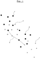
- Fig. 2 shows a diagram which contains statements regarding the probability of amounts of distances between two temporally one after another positions.
- the two curves a, b respectively describe how much a distance D1, D2 between two temporally successive positions is likely.
- curve a drops significantly steeper than curve b. That is, if curve a is for assuming the probability, the probability that the larger distance D2 is the true is much less than the probability that the smaller distance D1 is the more appropriate one, than curve b for assuming the probability serves.
- the selection of which curve a or b is used depends on which accelerations are measured on the acceleration sensor carried by the animal. If small acceleration values were measured during the time period for which the position is to be calculated, the steeper curve a is used, and if larger acceleration values were measured, curve b is used.
- the curves a, b may be assumed to be Gaussian normal distributions, and the assumed standard deviation, which is known to be involved in the calculation formula of the curves, may be assumed to be dependent on the measured acceleration.
- the dependency function should preferably be such that the standard deviation increases monotonously with increasing acceleration, for example, increases in direct proportion to the measured acceleration.
- Optimal curves and dependencies as the shape of the curves depend on the measured accelerations must be determined empirically. For this purpose, movements of animals - or robots, etc. - are logged on the one hand by direct observation, distance measurement and recording and on the other hand as described by radio location, acceleration measurements and merging calculation determined. The merging calculation is performed with different underlying calculation parameters (eg different dependencies of the standard deviations of curves according to Fig. 1 from the measured acceleration) until the two determination methods provide the best possible equally good results.
- the best of the possible paths g can be determined according to Fig. 1 are found by forming the respective products of the three probabilities of all possible paths along position sequences cdef which correspond to the respective distances cd, de and ef Fig. 1 are assigned and then that path is selected at which this product is highest. (In order to keep the computational effort within tolerable limits, the well-known methods Hidden-Markov-Model, in particular Viterbi algorithm mentioned in the introduction, should be used.)
- the acceleration value entering into the calculation of the probabilities is, strictly speaking, to be understood as a mathematically processed numerical value which consists of the majority the acceleration values measured in the respective current time period are formed and this plurality of values represents well. It may be a statistical mean, such as the root mean square (RMS) value, or the geometric sum of the rms values measured in single directions, or the arithmetic mean, or the average of the individual absolute values, etc., but it may also be a weighted mixture of various such averages or the magnitude of a vectorial sum of the individual detected acceleration vectors. In practice, the method of determination in question is best determined empirically. The selection depends not only on the theoretical mathematical precision but also, for example, on the measurement frequency, the measurement accuracy, the available computing capacity, etc.
- RMS root mean square
Landscapes
- Life Sciences & Earth Sciences (AREA)
- Environmental Sciences (AREA)
- Engineering & Computer Science (AREA)
- Physics & Mathematics (AREA)
- Radar, Positioning & Navigation (AREA)
- Remote Sensing (AREA)
- Animal Husbandry (AREA)
- Biodiversity & Conservation Biology (AREA)
- General Physics & Mathematics (AREA)
- Biophysics (AREA)
- Zoology (AREA)
- Birds (AREA)
- Probability & Statistics with Applications (AREA)
- Computer Networks & Wireless Communication (AREA)
- Health & Medical Sciences (AREA)
- Medical Informatics (AREA)
- General Health & Medical Sciences (AREA)
- Heart & Thoracic Surgery (AREA)
- Pathology (AREA)
- Molecular Biology (AREA)
- Surgery (AREA)
- Animal Behavior & Ethology (AREA)
- Biomedical Technology (AREA)
- Public Health (AREA)
- Veterinary Medicine (AREA)
- Automation & Control Theory (AREA)
- Position Fixing By Use Of Radio Waves (AREA)
- Mobile Radio Communication Systems (AREA)
- Radar Systems Or Details Thereof (AREA)
Description
Die Erfindung betrifft ein Verfahren für die Ortung von Tieren mit Hilfe von Funkwellen.The invention relates to a method for locating animals by means of radio waves.
Übliche Anlagen für die Ortung von Objekten, wie beispielsweise Tieren, mit Hilfe von Funkwellen, weisen mehrere Funksender und/oder Funkempfänger auf die sich an bekannten Positionen befinden, sowie jeweils einen Funksender und/oder Funkempfänger an jedem zu ortenden Objekt.Conventional installations for the location of objects, such as animals, by means of radio waves, have a plurality of radio transmitters and / or radio receivers located at known positions, and in each case a radio transmitter and / or radio receiver at each object to be located.
Des Weiteren werden die Sender bzw. Empfänger, welche für die Ortung mittels Funkwellen verwendet werden einfach als "Knoten" bezeichnet. Entsprechend einem häufig angewandten Verfahren wird für das Bestimmen der Position des an dem zu ortenden Tier angebrachten Knotens im ersten Schritt mit Hilfe von Funksignalen gemessen, um welche Länge sich die Abstände der einzelnen Knoten bekannter Position zu dem zu ortenden Knoten voneinander unterscheiden. Beispielsweise wird dazu von dem zu ortenden Knoten aus ein Signal gleichzeitig an alle anderen Knoten abgesandt. Die empfangenden Knoten messen den Zeitpunkt zu welchem dieses Signal bei ihnen ankommt. Die Differenzen zwischen den einzelnen gemessenen Zeitpunkten, jeweils multipliziert mit der Lichtgeschwindigkeit (Signalausbreitungsgeschwindigkeit im betreffenden Medium) ergeben die Abstandsunterschiede der einzelnen Knoten zum sendenden Knoten. Für die weitere Berechnung wird im ersten Schritt davon ausgegangen, dass sich der zu ortende Knoten auf einem Hyperboloid befindet, dessen Achse durch zwei Knoten bekannter Position als Brennpunkte verläuft, wobei der gemessene Abstandsunterschied dieser Knoten zu dem zu ortenden Knoten gleich jener Länge ist, um welche sich - definitionsgemäß - die Distanzen zwischen den beiden Brennpunkten zu jedem auf dem Hyperboloid befindlichen Punkt unterscheiden. Durch Schneiden von mindestens drei derartigen Hyperboloiden wird die mögliche Position des zu ortenden Gerätes auf zwei Punkte eingeschränkt. Die weitere Einschränkung auf einen Punkt kann mit Hilfe eines vierten Hyperboloids erfolgen (sodass also mindestens vier Knoten bekannter Position erforderlich sind) oder indem an Hand von bekannten geometrischen Gegebenheiten ein Punkt ohnedies ausgeschlossen werden kann, beispielsweise weil er sich außerhalb des Stalls innerhalb dessen sich Tiere bewegen können, befindet. (Mit "Hyperboloid" ist in diesem Text eine rotationssymmetrische schalenförmige Fläche gemeint, die als durch Rotation einer Hyperbel um ihre Hauptachse entstanden gedacht werden kann.)Furthermore, the transmitters or receivers which are used for the detection by means of radio waves are referred to simply as "nodes". In accordance with a frequently used method, in order to determine the position of the node attached to the animal to be located, in the first step radio signals are used to measure the length by which the distances of the individual nodes of known position to the node to be located differ from one another. For example, from the node to be located, a signal is simultaneously sent to all other nodes. The receiving nodes measure the time at which this signal arrives at them. The differences between the individual measured times, in each case multiplied by the speed of light (signal propagation speed in the relevant medium), give the distance differences of the individual nodes to the transmitting node. For the further calculation, it is assumed in the first step that the node to be located is located on a hyperboloid whose axis passes through two knots of known position as foci, the measured distance difference of these nodes to the node to be located being equal to that length which, by definition, differ in the distances between the two foci to each point on the hyperboloid. By cutting at least three such hyperboloids, the possible position of the device to be located is limited to two points. The further restriction to one point can be made by means of a fourth hyperboloid (so that at least four knots of known position are required) or by a point on the basis of known geometrical conditions can be excluded anyway, for example, because he is outside of the stable within which animals can move. (By "hyperboloid" in this text is meant a rotationally symmetric cup-shaped surface which may be thought of as being due to rotation of a hyperbola about its major axis.)
Wenn in einer Abwandlung zu dem beschriebenen Verfahren im ersten Schritt mittels Funkwellen direkt auf die Abstände zwischen dem Knoten an dem zu ortenden Tier zu den einzelnen Knoten bekannter Position geschlossen wird, so sind im zweiten Schritt anstatt der Hyperboloid-Schalen Kugelschalen anzunehmen.If in a modification to the described method in the first step by radio waves directly on the distances between the node at the animal to be located to the individual nodes known position is closed, so in the second step instead of the hyperboloid shells to accept spherical shells.
Mit Funklokalisierung von Tieren entsprechend dem erklärten Prinzip befassen sich beispielsweise die Schriften
Auf Grund von in der Praxis oftmals unvermeidbar vorkommenden erheblichen Messfehlern und Messungenauigkeiten - z.B. wegen Reflexionen von Funkwellen - sind weitere logische Annahmen einzubringen und dementsprechende Auswertungen vorzunehmen, um ein einigermaßen verlässliches Ortungsergebnis erhalten zu können. Neben dem schon erwähnten Ausschließen von Ergebnissen die auf Grund geometrischer Gegebenheiten unmöglich sind, werden vor allem stochastische Methoden herangezogen um auch an Hand der Ergebnisse vorhergegangener Messungen die Vieldeutigkeit des/der jeweils aktuellen Ergebnisse einzuschränken und jenes Messergebnis zu finden, welches mit der geringsten Fehlerwahrscheinlichkeit die Wirklichkeit widerspiegelt. Ein bewährtes stochastisches Modell ist in diesem Zusammenhang das Hidden-Markov-Model und dabei insbesondere der Viterbi-Algorithmus, mit Hilfe dessen relativ effizient aus einer Vielzahl von möglichen Zustandsfolgen die aktuell jeweils wahrscheinlichste Zustandsfolge gefunden werden kann.Due to considerable measurement errors and measurement inaccuracies, which are often unavoidable in practice - e.g. due to reflections from radio waves - additional logical assumptions have to be made and corresponding evaluations made in order to obtain a reasonably reliable locating result. In addition to the above-mentioned exclusion of results that are impossible due to geometric conditions, especially stochastic methods are used in order to limit the ambiguity of the current results by using the results of previous measurements and to find the measurement result which has the lowest probability of error Reality reflects. A proven stochastic model in this context is the Hidden Markov model and in particular the Viterbi algorithm, with the aid of which the currently most probable state sequence can be found relatively efficiently from a multiplicity of possible state sequences.
Eine üblicherweise für die Berechnung der Aufenthaltswahrscheinlichkeit angewandte Randbedingung ist, dass zumindest ab einer gewissen Grenzdistanz zwischen einem aktuell in Prüfung befindlichen Ort und dem zuletzt angenommen Aufenthaltsort, mit steigender Distanz die Wahrscheinlichkeit sinkt, dass der aktuell in Prüfung befindliche Ort der aktuelle Aufenthaltsort ist. Etwas vereinfacht ausgedrückt heißt das, dass ein aktueller Aufenthaltsort eines Tieres mit hoher Wahrscheinlichkeit nur innerhalb eines Kreises mit bestimmtem, begrenztem Radius vom letzten vorher angenommenen Aufenthaltsort liegen kann.A boundary condition usually used for the calculation of the probability of residence is that, at least over a certain limit distance between a location currently being examined and the last accepted location, the probability decreases with increasing distance that the location currently being examined is the current location. Expressed simply, this means that a current location of an animal with high probability can only lie within a circle with a certain, limited radius from the last previously assumed location.
Beispielsweise die
Beispielsweise in den Schriften
Die als Muster gespeicherten zeitlichen Verläufe sind dabei charakteristisch für bestimmte Aktivitäten des Tieres wie beispielsweise Gehen, Fressen, Wiederkäuen, Schlafen, ggf. hinkendes Gehen, Aufreiten auf andere Tiere. Für das Finden der charakteristischen Muster wurden in früheren Arbeiten Beschleunigungsdaten und parallel dazu die an Hand von unmittelbarer Beobachtung festgestellten Aktivitäten von Tieren aufgezeichnet und aus den aufgezeichneten Daten Korrelationen zwischen Beschleunigungsmustern und Aktivitäten herausgefiltert.The temporal patterns stored as a pattern are characteristic of certain activities of the animal such as walking, eating, rumination, sleeping, possibly limping, riding on other animals. In order to find the characteristic patterns, in earlier work acceleration data and at the same time the activities of animals determined by direct observation were recorded and correlations between acceleration patterns and activities were filtered out from the recorded data.
Die
Die
Die
Die
Von diesem Stand der Technik ausgehend liegt die Aufgabe an die Erfindung darin, ein auch in Laufställen und Koppeln für Tiere anwendbares automatisch ablaufendes Verfahren für die Ortung von Tieren mit Hilfe von Funkwellen bereitzustellen, welches gegenüber bekannten derartigen Verfahren bezogen auf den dafür erforderlichen Investitionsaufwand genauere und besser verlässliche Ergebnisse liefert.Starting from this prior art, the object of the invention is to provide an automatically executable method for the detection of animals by means of radio waves also applicable in pens and paddocks for animals, which compared to known such methods relative to the investment required for this investment more accurate and provides better reliable results.
Zum Lösen der Aufgabe wird von der bekannten Methode der Funkortung ausgegangen, wonach stochastische Berechnungen angewandt werden, um an Hand der Ergebnisse vorhergegangener Messungen und Berechnungen bezüglich der möglichen Position des zu ortenden Knotens, aus der Mehrzahl der jeweils aktuellen Positions-Berechnungsergebnisse jenes Ergebnis herauszufiltern, welches mit der höchsten Wahrscheinlichkeit (also mit der geringsten Fehlerwahrscheinlichkeit) tatsächlich die aktuelle Position beschreibt, wobei als eine Randbedingung mit einfließt, dass zumindest ab einer gewissen Grenzdistanz zwischen der durch ein aktuelles Berechnungsergebnis definierten Position und der zuletzt angenommenen Position des zu ortenden Knotens, mit steigender Distanz zwischen den beiden Positionen, die Wahrscheinlichkeit sinkt, dass die Position gemäß dem aktuellen Berechnungsergebnis die tatsächliche Position des zu ortenden Knotens ist.To solve the problem, the known method of radiolocation is used, according to which stochastic calculations are used to filter out the result of previous measurements and calculations with respect to the possible position of the node to be located, from the majority of the respective current position calculation results, which with the highest probability (that is to say with the lowest probability of error) actually describes the current position, with at least a certain limit distance between the position defined by a current calculation result and the last assumed position of the node to be located, with at least a certain limiting distance increasing distance between the two positions, the probability decreases that the position according to the current calculation result is the actual position of the node to be located.
Erfindungsgemäß wird vorgeschlagen, das Verfahren zu verbessern, indem auch Beschleunigungsdaten am zu ortenden Tier gemessen werden und die gemessenen Beschleunigungsdaten derart in die Wahrscheinlichkeit miteinfließen, dass dann wenn höhere Beschleunigungswerte gemessen werden, die Wahrscheinlichkeit für größere Distanz zwischen zwei zeitlich nacheinander eingenommenen Aufenthaltsorten zu Ungunsten der Wahrscheinlichkeit für kleinere Distanz zwischen zwei zeitlich nacheinander eingenommenen Aufenthaltsorten, als vergrößert angenommen wird.According to the invention, it is proposed to improve the method by also measuring acceleration data on the animal to be located and including the measured acceleration data in the probability such that when higher acceleration values are measured, the probability of greater distance between two temporally successive occupied locations to the detriment of Probability of smaller distance between two temporally successively occupied whereabouts is assumed to be increased.
Die Erfindung wird unter Zuhilfenahme von Zeichnung zu einer vorteilhaften beispielhaften erfindungsgemäßen Verfahrensvariante verdeutlich:
- Fig. 1:
- veranschaulicht stark stilisiert, die Aufgabenstellung aus vielen errechneten Aufenthaltsorten jene Folge von Aufenthaltsorten herauszufinden, die mit der höchsten Wahrscheinlichkeit der Wirklichkeit entspricht.
- Fig. 2:
- zeigt in kartesischer Koordinatendarstellung zwei angenommene Wahrscheinlichkeitsverläufe a, b für die Größe von Distanzen zwischen zeitlich aufeinanderfolgend durch Messung und Berechnung gefundenen möglichen Positionen (Aufenthaltsorten) des zu ortenden Knotens.
- Fig. 1:
- In a highly stylized way, the task from many calculated locations reveals the sequence of locations most likely to correspond to reality.
- Fig. 2:
- shows in Cartesian coordinate representation two assumed probability curves a, b for the size of distances between temporally successively found by measurement and calculation possible positions (locations) of the node to be located.
Ein Funkortungssystem für das Feststellen des Aufenthaltsortes und der Bewegungen eines Tieres weist - wie weiter oben näher erklärt - mehrere Knoten auf, wobei das Tier, welches sich frei bewegen kann, den zu ortenden Knoten trägt und eine Mehrzahl von weiteren Knoten unbeweglich montiert sind und ihre relative Lage zueinander bekannt ist. In geregelten zeitlichen Abständen wird ein Mess- und Berechnungsablauf für die Funkortung durchgeführt. Wie weiter oben beschrieben, ist die Messung entweder eine Abstandsmessungen zwischen dem zu ortenden Knoten und den Knoten bekannter Position oder die Messung der Differenzen der Abstände zwischen dem zu ortenden Knoten und den einzelnen Knoten bekannter Position. Aus den Messergebnissen wird durch geometrische Berechnung auf die mögliche Position des zu ortenden Knotens (relativ zu den Knoten bekannter Position) zurückgeschlossen. Auf Grund dessen, dass sehr oft mehr als vier Knoten bekannter Position vorliegen und dass Funksignale zwischen zwei Knoten im Normalfall nicht nur in direkter gerader Linie übertragen werden, sondern zufolge Reflexion zusätzlich über weitere, längere Wege, fällt eine Vielzahl von Messereignissen an die man mathematisch als ein überbestimmtes, in sich widersprüchliches System bezeichnen kann. Konkret heißt das, dass man dann, wenn man immer die jeweils letzten vier Empfangsereignisse von Funksignalen zwischen dem zu ortenden Knoten und jeweils einem anderen Knoten bekannter Position zur Berechnung der Position des zu ortenden Knotens verwendet, eine Vielzahl von Berechnungsergebnissen erhält, die jeweils eine Position im Raum beschreiben, wobei aber nur ein kleiner Teil dieser Berechnungsergebnisse tatsächlich die Positionen des zu ortenden Knotens beschreiben. Die überwiegende Anzahl der Berechnungsergebnisse hingegen ist falsch.A radio location system for determining the location and movements of an animal has - as explained in more detail above - several nodes, wherein the animal, which can move freely carries the node to be located and a plurality of other nodes are immovably mounted and their Relative position is known to each other. At regular intervals, a measurement and calculation procedure for the radio location is performed. As described above, the measurement is either a distance measurement between the node to be located and the nodes of known position or the measurement of the differences in the distances between the node to be located and the individual nodes of known position. From the measurement results, geometric calculation is used to deduce the possible position of the node to be located (relative to the nodes of known position). Due to the fact that very often more than four nodes are known position and that radio signals between two nodes are normally transmitted not only in a direct straight line, but also reflection over additional, longer paths, a multitude of measuring events falls to the one mathematically as an over-determined, self-contradictory system. Specifically, this means that, if one always uses the last four reception events of radio signals between the node to be located and another known position node for calculating the position of the node to be located, one obtains a plurality of calculation results, each one position in space, but only a small portion of these computational results actually describe the positions of the node to be located. The vast majority of the calculation results, however, is wrong.
In
Von vornherein kann man als feststehend annehmen, dass auf dem tatsächlichen Weg des zu ortenden Knotens auf eine einzige der Positionen c eine einzige der Positionen d folgt, dann eine einzige der Positionen e und schließlich eine einzige der Positionen f. Stellvertretend für die Unzahl von damit prinzipiell möglichen Wegen ist in
Zur Berechnung, welcher Weg tatsächlich am wahrscheinlichsten die Wirklichkeit wiederspiegelt, zieht man in Betracht, dass die möglichen Distanzen zwischen zwei zeitlich unmittelbar hintereinander folgenden Positionen (c und d, d und e, e und f) nicht allesamt gleich wahrscheinlich sind, sondern dass manche Klassen von Distanzen mehr wahrscheinlich sind und andere weniger. Extrem große Distanzen beispielsweise sind unmöglich, weil sie bedeuten würden, dass sich das Tier, welches den zu ortenden Knoten trägt, schneller bewegen müsste als es die Grenzen von Biologie und Technik zulassen.To calculate which way is most likely to reflect reality, consider that the possible distances between two consecutive positions (c and d, d and e, e and f) are not all equally probable, but some Classes of distances are more likely and others less. Extremely long distances, for example, are impossible because they would mean that the animal carrying the node to be located would have to move faster than the limits of biology and technology allow.
Die beiden Kurven a, b beschreiben jeweils, wie sehr eine Distanz D1, D2 zwischen zwei zeitlich aufeinanderfolgenden Positionen wahrscheinlich ist.The two curves a, b respectively describe how much a distance D1, D2 between two temporally successive positions is likely.
Wenn z. B. Kurve a gilt und für einen Zeitpunkt genau zwei mögliche Distanzen D1 und D2 errechnet werden, so zeigt das Größenverhältnis der den Distanzen D1 bzw. D2 zugeordneten Ordinatenmaße Pa1 und Pa2 zueinander das Verhältnis der Wahrscheinlichkeit das D1 zutrifft zur Wahrscheinlichkeit das D2 zutrifft. Für die weiterführende Berechnung muss die absolute Größe der Wahrscheinlichkeiten noch so normiert werden, dass die Summe der Wahrscheinlichkeiten über alle möglichen Positionen immer den gleichen Wert ergibt (am besten 1).If z. If, for example, curve a is valid and exactly two possible distances D1 and D2 are calculated for a given time, then the ratio of the ordinate dimensions Pa1 and Pa2 associated with the distances D1 or D2 to one another shows the ratio of the probability D1 matches the probability that D2 applies. For the further calculation, the absolute size of the probabilities must be normalized so that the sum of the probabilities over all possible positions always yields the same value (preferably 1).
Beide Kurven a und b haben das Maximum bei D=0, womit gemäß beiden Kurven Distanzen zwischen zeitlich aufeinander folgenden Positionen umso wahrscheinlicher sind, umso kleiner die Distanzen sind.Both curves a and b have the maximum at D = 0, which according to both curves distances between temporally successive positions are the more probable, the smaller the distances are.
Kurve a fällt aber deutlich steiler ab als Kurve b. Das bedeutet, dass dann wenn Kurve a zur Annahme der Wahrscheinlichkeit dient, die Wahrscheinlichkeit dass die größere Distanz D2 die Zutreffende ist, gegenüber der Wahrscheinlichkeit dass die kleinere Distanz D1 die Zutreffendere ist, sehr viel geringer ist, als wenn Kurve b zur Annahme der Wahrscheinlichkeit dient.However, curve a drops significantly steeper than curve b. That is, if curve a is for assuming the probability, the probability that the larger distance D2 is the true is much less than the probability that the smaller distance D1 is the more appropriate one, than curve b for assuming the probability serves.
Erfindungsgemäß ist vorgesehen, dass die Auswahl, welche Kurve a oder b verwendet wird, davon abhängig ist, welche Beschleunigungen an dem vom Tier mitgeführten Beschleunigungssensor gemessen werden. Wenn während der Zeitperiode für welche die Position zu berechnen ist, kleine Beschleunigungswerte gemessen wurden, wird die steilere Kurve a herangezogen, wenn größere Beschleunigungswerte gemessen wurden, wird Kurve b herangezogen.According to the invention, the selection of which curve a or b is used depends on which accelerations are measured on the acceleration sensor carried by the animal. If small acceleration values were measured during the time period for which the position is to be calculated, the steeper curve a is used, and if larger acceleration values were measured, curve b is used.
Die Kurven a, b können beispielsweise als eine Normalverteilung nach Gauß angenommen sein, wobei die in die Berechnungsformel der Kurven bekanntermaßen miteinfließende angenommene Standardabweichung als von der gemessenen Beschleunigung abhängig angenommen werden kann. Die Abhängigkeitsfunktion sollte bevorzugt so sein, dass mit steigender Beschleunigung die Standardabweichung monoton mit steigt, beispielsweise direkt proportional zur gemessenen Beschleunigung mit steigt.For example, the curves a, b may be assumed to be Gaussian normal distributions, and the assumed standard deviation, which is known to be involved in the calculation formula of the curves, may be assumed to be dependent on the measured acceleration. The dependency function should preferably be such that the standard deviation increases monotonously with increasing acceleration, for example, increases in direct proportion to the measured acceleration.
Optimale Kurvenverläufe und Abhängigkeiten wie die Form der Kurven von den gemessenen Beschleunigungen abhängig sind, müssen empirisch ermittelt werden. Dazu werden Bewegungsabläufe von Tieren - oder Robotern etc. - einerseits durch direkte Beobachtung, Wegmessung und Aufzeichnung protokolliert und andererseits wie beschrieben durch Funkortung, Beschleunigungsmessungen und zusammenführende Berechnung ermittelt. Die zusammenführende Berechnung wird mit unterschiedlichen zu Grunde liegenden Berechnungsparametern (z.B. unterschiedliche Abhängigkeiten der Standardabweichungen von Kurven gemäß
Wenn alle Berechnungsparameter richtig angenommen wurden und in die Berechnung miteinfließen, kann der beste der möglichen Wege g gemäß
Unter dem in die Berechnung der Wahrscheinlichkeiten eingehenden Beschleunigungswert ist genaugenommen ein mathematisch aufbereiteter Zahlenwert zu verstehen, der aus der Mehrzahl der in der jeweils aktuellen Zeitperiode gemessenen Beschleunigungswerte gebildet wird und diese Mehrzahl von Werten gut repräsentiert. Es kann ein statistischer Mittelwert wie beispielsweise der Effektivwert (quadratischer Mittelwert) sein, oder die geometrische Summe der in einzelnen Richtungen gemessenen Effektivwerte oder der arithmetische Mittelwert oder der Mittelwert der einzelnen Absolutwerte, etc. sein, es kann aber auch eine gewichtete Mischung verschiedener derartiger Mittelwerte sein oder der Betrag einer vektoriellen Summe der einzelnen festgestellten Beschleunigungsvektoren. In der Praxis ermittelt man die diesbezügliche Festlegungsmethode wiederum am besten empirisch. Die Auswahl ist nicht nur von der theoretischen mathematischen Präzision sondern beispielsweise auch von der Messfrequenz, der Messgenauigkeit, der verfügbaren Rechenkapazität etc. abhängig.The acceleration value entering into the calculation of the probabilities is, strictly speaking, to be understood as a mathematically processed numerical value which consists of the majority the acceleration values measured in the respective current time period are formed and this plurality of values represents well. It may be a statistical mean, such as the root mean square (RMS) value, or the geometric sum of the rms values measured in single directions, or the arithmetic mean, or the average of the individual absolute values, etc., but it may also be a weighted mixture of various such averages or the magnitude of a vectorial sum of the individual detected acceleration vectors. In practice, the method of determination in question is best determined empirically. The selection depends not only on the theoretical mathematical precision but also, for example, on the measurement frequency, the measurement accuracy, the available computing capacity, etc.
Als Ergebnis der Überwachung der Bewegungen eines Tieres ist vor allem interessant, wieviel Weg das Tier in einer Zeitperiode (z.B. in einem Tag) zurückgelegt hat, weil das sehr viel über den Grad der Aktivität des Tieres und damit über den Zustand des Tieres aussagt. Die Kenntnis der exakten Positionen die das Tier zu den einzelnen Zeitpunkten innehatte, ist hingegen weniger aussagekräftig und damit auch weniger interessant.As a result of monitoring the movements of an animal, it is particularly interesting to know how much way the animal has traveled in a period of time (for example in one day), because this tells a great deal about the degree of activity of the animal and thus about the condition of the animal. The knowledge of the exact positions that the animal held at each time point, however, is less meaningful and thus less interesting.
Vor allem wenn es um die Überwachung des gesamten Weges, den ein Tier in einer "längeren Zeitperiode" (z.B. eine Stunde oder ein Tag) zurücklegt geht, wirken sich Fehler der Funkortung relativ gesehen sehr stark aus, wenn das Tier wenig Bewegung macht und damit auch geringe Beschleunigungen gemessen werden.Especially when it comes to monitoring the entire journey that an animal takes in a "longer period of time" (eg an hour or a day), errors of the radio positioning relatively speaking affect very strongly, if the animal makes little movement and thus even low accelerations can be measured.
Daher ist es gemäß einer bevorzugten Weiterentwicklung des erfindungsgemäßen Verfahrens zu empfehlen, in die Berechnung der wahrscheinlichsten Trajektorie die ein an einem Tier befestigter Knoten eines Funkortungssystems zurücklegt, mit einfließen zu lassen, dass Ergebnisse des Funkortungssystems - also die durch Funksignalübertragung gewonnenen Informationen über den Abstand des zu ortenden Knotens von Knoten bekannter Position bzw. über den Abstand zwischen zeitlich aufeinanderfolgenden Positionen des zu ortenden Knotens - die gewonnen wurden, während hohe Beschleunigungswerte gemessen wurden, mit höherer Wahrscheinlichkeit zutreffend sind, als Ergebnisse des Funkortungssystems die gewonnen wurden, während niedrige Beschleunigungswerte gemessen wurden.Therefore, according to a preferred further development of the method according to the invention, it is recommended to include in the calculation of the most probable trajectory an animal-mounted node of a radio location system, that results of the radio location system - ie the information obtained by radio signal transmission over the distance of the radio location of nodes of known position or the distance between successive positions of the node to be located - which were obtained while high acceleration values were measured - are more likely to be applicable than results of the radio location system obtained while low acceleration values were measured ,
Es gibt eine Vielzahl von Möglichkeiten, das in die konkrete Berechnung der als am wahrscheinlichsten anzusehenden Trajektorie einzubringen. Als extrem einfache beispielhafte Methode kann man Messergebnisse der Funkortung, die für Zeitbereiche gelten an denen der Betrag der gemessenen Beschleunigung unterhalb einer bestimmten Mindestgrenze lag, einfach ignorieren. Die letztendlich angenommene Trajektorie verläuft dann auf direktmöglichstem Weg nur zwischen jenen möglichen Ergebnispositionen der Funkortung die für Zeitpunkte gelten bei denen Beschleunigungen gemessen wurden die über dem besagten Mindestwert liegen.There are a variety of ways to bring this into the concrete calculation of the most likely to be considered trajectory. As an extremely simple exemplary method If one can simply ignore measurement results of the radio positioning, which apply to time ranges in which the amount of the measured acceleration was below a certain minimum limit. The finally assumed trajectory then proceeds in the most direct possible way only between those possible result positions of the radiolocation which apply to times at which accelerations were measured which are above the said minimum value.
Claims (4)
- A method for locating an animal by means of radio waves, wherein the animal is provided with a node of a radio wave location system to be located and wherein a plurality of further nodes of the radio wave location system are provided at known positions, wherein the radio wave signals are transmitted between the node to be located and the nodes having known positions and wherein individual distances and/or individual distance differences between the individual nodes having known positions on the one hand and the node to be located on the other hand are calculated from the parameters measured during the signal transmission and wherein, by a data processing device, possible positions of the node to be located are calculated from several such calculation results,
characterised in that
stochastic calculations are used in order to, based on the results of preceding measurements and calculations regarding the possible position of the node to be located, the one result out of the plurality of the current position calculation results is filtered out which with maximum likelihood actually describes the current position, wherein there is included the constraint that at least from a certain limiting distance between the position defined by a current calculation result and the latest assumed position of the node to be located, upon increasing distance between the two positions, the likelihood decreases that the position according to the current calculation result is the actual position of the node to be located, wherein there are also measured acceleration data on the animal provided with the node to be located and the measured acceleration data are transmitted to the data processing device,
wherein the assumption of said likelihood depends on the measured acceleration data, wherein, for greater measured acceleration values, the likelihood for greater distances between two temporally subsequently adopted positions is assumed to be increased at the detriment of the likelihood for a smaller distance between two temporally subsequently adopted positions. - Method according to claim 1, characterised in that the likelihood for the value of a distance between two temporally subsequent positions of the node to be located is assumed to be at least approximately distributed following a normal Gaussian distribution, depending on the modulus of the distance, wherein the standard deviation is assumed to increase monotonicaly with the measured acceleration.
- Method according to claim 1 or 2, characterised in that the acceleration value taken into account in the assumption of the likelihood is a statistical average of temporally subsequent measurement values of accelerations.
- Method according to one of claims 1 to 3, characterised in that, in the calculation of the most likely sequence of a series of positions which the node to be located has adopted, distance information regarding the node to be located measured from the radio wave transmission are taken into account with a higher likelihood of being accurate if, in the acceleration measurement, higher acceleration values are determined than if in the acceleration measurement lower acceleration values are determined.
Priority Applications (1)
| Application Number | Priority Date | Filing Date | Title |
|---|---|---|---|
| PL16739010T PL3308191T3 (en) | 2015-06-12 | 2016-06-09 | Method for locating animals using radio waves |
Applications Claiming Priority (2)
| Application Number | Priority Date | Filing Date | Title |
|---|---|---|---|
| ATA374/2015A AT517225B1 (en) | 2015-06-12 | 2015-06-12 | Method for locating animals using radio waves |
| PCT/AT2016/000064 WO2016197160A1 (en) | 2015-06-12 | 2016-06-09 | Method for locating animals using radio waves |
Publications (2)
| Publication Number | Publication Date |
|---|---|
| EP3308191A1 EP3308191A1 (en) | 2018-04-18 |
| EP3308191B1 true EP3308191B1 (en) | 2019-07-24 |
Family
ID=56413436
Family Applications (1)
| Application Number | Title | Priority Date | Filing Date |
|---|---|---|---|
| EP16739010.3A Active EP3308191B1 (en) | 2015-06-12 | 2016-06-09 | Method for locating animals using radio waves |
Country Status (8)
| Country | Link |
|---|---|
| US (1) | US11035924B2 (en) |
| EP (1) | EP3308191B1 (en) |
| CN (1) | CN107690588B (en) |
| AT (1) | AT517225B1 (en) |
| AU (1) | AU2016275540B2 (en) |
| PL (1) | PL3308191T3 (en) |
| RU (1) | RU2702756C2 (en) |
| WO (1) | WO2016197160A1 (en) |
Families Citing this family (1)
| Publication number | Priority date | Publication date | Assignee | Title |
|---|---|---|---|---|
| NL2025037B1 (en) * | 2020-03-03 | 2021-10-14 | Nedap Nv | Location validation unit for validating a location of at least one animal, livestock management system, method and computer program. |
Family Cites Families (40)
| Publication number | Priority date | Publication date | Assignee | Title |
|---|---|---|---|---|
| US3999611A (en) | 1974-11-18 | 1976-12-28 | Louis Bucalo | Devices relating to hooves |
| GB2234070A (en) | 1989-06-12 | 1991-01-23 | Anthony Alexander Scarisbrick | Analysis of performance during an exercise activity |
| NL9102182A (en) | 1991-12-24 | 1993-07-16 | Stichting Inst Mech | METHOD AND APPARATUS FOR DETERMINING THE STATE OF AN ANIMAL |
| GB2278198B (en) | 1993-05-20 | 1997-01-29 | Mini Agriculture & Fisheries | Condition indicator |
| US6122960A (en) | 1995-12-12 | 2000-09-26 | Acceleron Technologies, Llc. | System and method for measuring movement of objects |
| US6317049B1 (en) | 1998-02-17 | 2001-11-13 | Souhail Toubia | Apparatus and method for locating missing persons, animals, and objects |
| US6113539A (en) | 1999-01-27 | 2000-09-05 | K.E.R. Associates, Inc. | Physical monitoring system for feedlot animals |
| EP1109031A1 (en) * | 1999-12-10 | 2001-06-20 | Ascom Systec AG | Method and apparatus to localise a mobile terminal |
| DE10045469C2 (en) | 2000-09-14 | 2002-12-05 | Reinhard Ludwig | Electronic monitoring of a herd of animals |
| KR20010074568A (en) | 2001-05-08 | 2001-08-04 | 이중호 | The acceleration sensing motion sensor and Method for sensing therof |
| DE10164534A1 (en) | 2001-12-31 | 2003-07-10 | Dirk Parchmann | Device and method for determining parameters of the movement of a body |
| US7250907B2 (en) | 2003-06-30 | 2007-07-31 | Microsoft Corporation | System and methods for determining the location dynamics of a portable computing device |
| US7592909B2 (en) * | 2006-01-19 | 2009-09-22 | Board Of Regents, The University Of Texas System | Location and tracking system using wireless technology |
| ITBA20040059A1 (en) * | 2004-12-23 | 2005-03-23 | Matrix Srl | LOCALIZATION SYSTEM FOR PEOPLE, ANIMALS AND THINGS, BY INNOVATIVE NETWORK OF TRANSCEIVERS WITHOUT CABLES AND LOW ENERGY CONSUMPTION |
| IL166394A0 (en) | 2005-01-19 | 2006-01-15 | Vladimir Voronin | A system and apparatus for detecting estrus |
| EP1887856B1 (en) * | 2005-05-24 | 2017-12-27 | Commonwealth Scientific and Industrial Research Organisation | Animal management system |
| US7616124B2 (en) | 2005-10-11 | 2009-11-10 | Snif Labs, Inc. | Tag system |
| US7904097B2 (en) * | 2005-12-07 | 2011-03-08 | Ekahau Oy | Location determination techniques |
| US8055469B2 (en) * | 2006-03-03 | 2011-11-08 | Garmin Switzerland Gmbh | Method and apparatus for determining the attachment position of a motion sensing apparatus |
| KR100815152B1 (en) * | 2006-11-07 | 2008-03-19 | 한국전자통신연구원 | Apparatus and method for integrated navigation using multi filter fusion |
| US7821406B2 (en) * | 2007-02-27 | 2010-10-26 | Wangrud Carole A | System for monitoring and tracking animals |
| AT506628B1 (en) * | 2008-03-27 | 2012-01-15 | Schauer Maschinenfabrik Gmbh | DEVICE FOR MONITORING ANIMAL ESTABLISHMENTS HELD IN A STABLE |
| CN102056478A (en) * | 2008-05-05 | 2011-05-11 | 斯马特尔农业股份有限公司 | Detection of moving objects |
| US20100130230A1 (en) * | 2008-11-21 | 2010-05-27 | Qualcomm Incorporated | Beacon sectoring for position determination |
| WO2010108496A1 (en) | 2009-03-25 | 2010-09-30 | Smarter Farming A/S | System and method for detecting behaviour of animals |
| ITPV20090004A1 (en) | 2009-03-27 | 2010-09-28 | Promogreen Com Srl | SYSTEM FOR LOCALIZATION AND TRAINING |
| RU2432581C1 (en) * | 2010-03-03 | 2011-10-27 | Общество с ограниченной ответственностью "РТЛ-Сервис" | Method to locate radio centre, system of radio centre location and unit of data processing |
| AT509892B1 (en) | 2010-06-09 | 2014-06-15 | Mkw Electronics Gmbh | ANIMAL BRAND |
| AT13366U1 (en) | 2010-12-15 | 2013-11-15 | Mkw Electronics Gmbh | A method of displaying information associated with an animal |
| DE102011000250A1 (en) * | 2011-01-21 | 2012-07-26 | Vorwerk & Co. Interholding Gmbh | Method for determining the position of a self-moving device |
| WO2012167301A1 (en) | 2011-06-10 | 2012-12-13 | Navisens Pty Ltd | Positioning, tracking and trajectory estimation of a mobile object |
| US8706137B2 (en) * | 2011-08-02 | 2014-04-22 | Qualcomm Incorporated | Likelihood of mobile device portal transition |
| EP2615598B1 (en) | 2012-01-11 | 2017-12-06 | Honda Research Institute Europe GmbH | Vehicle with computing means for monitoring and predicting traffic participant objects |
| CN103827632B (en) * | 2012-09-06 | 2017-02-15 | 株式会社东芝 | Position detection device and position detection method |
| CN103134494B (en) * | 2012-12-05 | 2015-07-29 | 中国科学院深圳先进技术研究院 | Automobile navigation method in indoor environment and device |
| US8934921B2 (en) * | 2012-12-14 | 2015-01-13 | Apple Inc. | Location determination using fingerprint data |
| AT515088B1 (en) * | 2014-02-14 | 2015-06-15 | Mkw Electronics Gmbh | Method for locating animals using radio waves |
| AT515870A3 (en) * | 2014-06-05 | 2022-06-15 | Smartbow Gmbh | Data network for monitoring animals |
| GB201500411D0 (en) * | 2014-09-15 | 2015-02-25 | Isis Innovation | Determining the position of a mobile device in a geographical area |
| CN110381734A (en) * | 2017-02-27 | 2019-10-25 | 艾集森斯私人有限公司 | Animal wearable device |
-
2015
- 2015-06-12 AT ATA374/2015A patent/AT517225B1/en active
-
2016
- 2016-06-09 PL PL16739010T patent/PL3308191T3/en unknown
- 2016-06-09 RU RU2017144307A patent/RU2702756C2/en active
- 2016-06-09 WO PCT/AT2016/000064 patent/WO2016197160A1/en active Application Filing
- 2016-06-09 EP EP16739010.3A patent/EP3308191B1/en active Active
- 2016-06-09 AU AU2016275540A patent/AU2016275540B2/en active Active
- 2016-06-09 CN CN201680033017.4A patent/CN107690588B/en active Active
- 2016-06-09 US US15/580,305 patent/US11035924B2/en active Active
Non-Patent Citations (1)
| Title |
|---|
| None * |
Also Published As
| Publication number | Publication date |
|---|---|
| WO2016197160A1 (en) | 2016-12-15 |
| US20180160650A1 (en) | 2018-06-14 |
| AT517225B1 (en) | 2016-12-15 |
| RU2017144307A (en) | 2019-07-12 |
| CN107690588A (en) | 2018-02-13 |
| AU2016275540A1 (en) | 2017-12-14 |
| AT517225A4 (en) | 2016-12-15 |
| EP3308191A1 (en) | 2018-04-18 |
| BR112017026541A2 (en) | 2018-08-14 |
| US11035924B2 (en) | 2021-06-15 |
| RU2702756C2 (en) | 2019-10-11 |
| PL3308191T3 (en) | 2020-01-31 |
| AU2016275540B2 (en) | 2020-04-09 |
| RU2017144307A3 (en) | 2019-09-19 |
| CN107690588B (en) | 2021-08-24 |
Similar Documents
| Publication | Publication Date | Title |
|---|---|---|
| EP3104694B1 (en) | Method for locating animals | |
| EP2427781B1 (en) | Design for determining an estimated value for a position of a reception element | |
| EP3538843A1 (en) | Estimation of an individual position | |
| DE19633884A1 (en) | Procedure for fault-tolerant position determination of an object | |
| EP2554956A1 (en) | Tracking taking mobility into consideration | |
| DE102004052110B4 (en) | Method for level measurement according to the transit time principle | |
| EP3308191B1 (en) | Method for locating animals using radio waves | |
| DE102015225577A1 (en) | Improved method for determining the edge development of a roadway for the localization of motor vehicles | |
| DE102014003152A1 (en) | Method and device for determining at least one object parameter of a means of transport | |
| DE3740656A1 (en) | NAVIGATION METHOD AND DEVICE FOR DETERMINING THE RELATIVE POSITION AND CALCULATING THE ARTIFICIAL AZIMUT | |
| DE102020208378B3 (en) | Traffic light lane assignment from swarm data | |
| EP4277827A1 (en) | Orientation-based position determination for rail vehicles | |
| DE102018218386B4 (en) | OBJECT DETECTION DEVICE | |
| DE102020107950A1 (en) | Procedure for fault detection and safe sensor system | |
| EP3655934B1 (en) | Concept for monitoring a parking space | |
| EP3532317B1 (en) | Method for operating a tyre pressure monitoring unit and tyre pressure monitoring system | |
| WO2011036013A1 (en) | Method and device for determining the position of a watercraft | |
| DE102017220506A1 (en) | Method and device for estimating a maritime traffic condition | |
| DE10242808B4 (en) | Method and device for detecting obstacles and / or road users | |
| DE10238896B4 (en) | Method for evaluating radar data | |
| EP3295126B1 (en) | Method for determining states of a system using an estimation filter | |
| DE102005033227A1 (en) | Determining global positional data e.g. for network node, requires application of positional data to internal coordinate system for sub-set of nodes | |
| AT525604B1 (en) | Method and device for determining the composition of a layered snow profile | |
| WO2012123545A1 (en) | Method and device for fusing partitioned correlated signals | |
| EP4176285B1 (en) | Doppler-based determination of velocity direction |
Legal Events
| Date | Code | Title | Description |
|---|---|---|---|
| STAA | Information on the status of an ep patent application or granted ep patent |
Free format text: STATUS: THE INTERNATIONAL PUBLICATION HAS BEEN MADE |
|
| PUAI | Public reference made under article 153(3) epc to a published international application that has entered the european phase |
Free format text: ORIGINAL CODE: 0009012 |
|
| STAA | Information on the status of an ep patent application or granted ep patent |
Free format text: STATUS: REQUEST FOR EXAMINATION WAS MADE |
|
| 17P | Request for examination filed |
Effective date: 20180103 |
|
| AK | Designated contracting states |
Kind code of ref document: A1 Designated state(s): AL AT BE BG CH CY CZ DE DK EE ES FI FR GB GR HR HU IE IS IT LI LT LU LV MC MK MT NL NO PL PT RO RS SE SI SK SM TR |
|
| AX | Request for extension of the european patent |
Extension state: BA ME |
|
| DAV | Request for validation of the european patent (deleted) | ||
| DAX | Request for extension of the european patent (deleted) | ||
| GRAP | Despatch of communication of intention to grant a patent |
Free format text: ORIGINAL CODE: EPIDOSNIGR1 |
|
| STAA | Information on the status of an ep patent application or granted ep patent |
Free format text: STATUS: GRANT OF PATENT IS INTENDED |
|
| INTG | Intention to grant announced |
Effective date: 20190124 |
|
| GRAS | Grant fee paid |
Free format text: ORIGINAL CODE: EPIDOSNIGR3 |
|
| GRAA | (expected) grant |
Free format text: ORIGINAL CODE: 0009210 |
|
| STAA | Information on the status of an ep patent application or granted ep patent |
Free format text: STATUS: THE PATENT HAS BEEN GRANTED |
|
| AK | Designated contracting states |
Kind code of ref document: B1 Designated state(s): AL AT BE BG CH CY CZ DE DK EE ES FI FR GB GR HR HU IE IS IT LI LT LU LV MC MK MT NL NO PL PT RO RS SE SI SK SM TR |
|
| REG | Reference to a national code |
Ref country code: GB Ref legal event code: FG4D Free format text: NOT ENGLISH |
|
| REG | Reference to a national code |
Ref country code: CH Ref legal event code: EP |
|
| REG | Reference to a national code |
Ref country code: DE Ref legal event code: R096 Ref document number: 502016005710 Country of ref document: DE |
|
| REG | Reference to a national code |
Ref country code: AT Ref legal event code: REF Ref document number: 1158828 Country of ref document: AT Kind code of ref document: T Effective date: 20190815 |
|
| REG | Reference to a national code |
Ref country code: IE Ref legal event code: FG4D Free format text: LANGUAGE OF EP DOCUMENT: GERMAN |
|
| REG | Reference to a national code |
Ref country code: NL Ref legal event code: FP |
|
| REG | Reference to a national code |
Ref country code: LT Ref legal event code: MG4D |
|
| PG25 | Lapsed in a contracting state [announced via postgrant information from national office to epo] |
Ref country code: BG Free format text: LAPSE BECAUSE OF FAILURE TO SUBMIT A TRANSLATION OF THE DESCRIPTION OR TO PAY THE FEE WITHIN THE PRESCRIBED TIME-LIMIT Effective date: 20191024 Ref country code: NO Free format text: LAPSE BECAUSE OF FAILURE TO SUBMIT A TRANSLATION OF THE DESCRIPTION OR TO PAY THE FEE WITHIN THE PRESCRIBED TIME-LIMIT Effective date: 20191024 Ref country code: FI Free format text: LAPSE BECAUSE OF FAILURE TO SUBMIT A TRANSLATION OF THE DESCRIPTION OR TO PAY THE FEE WITHIN THE PRESCRIBED TIME-LIMIT Effective date: 20190724 Ref country code: PT Free format text: LAPSE BECAUSE OF FAILURE TO SUBMIT A TRANSLATION OF THE DESCRIPTION OR TO PAY THE FEE WITHIN THE PRESCRIBED TIME-LIMIT Effective date: 20191125 Ref country code: LT Free format text: LAPSE BECAUSE OF FAILURE TO SUBMIT A TRANSLATION OF THE DESCRIPTION OR TO PAY THE FEE WITHIN THE PRESCRIBED TIME-LIMIT Effective date: 20190724 Ref country code: SE Free format text: LAPSE BECAUSE OF FAILURE TO SUBMIT A TRANSLATION OF THE DESCRIPTION OR TO PAY THE FEE WITHIN THE PRESCRIBED TIME-LIMIT Effective date: 20190724 Ref country code: HR Free format text: LAPSE BECAUSE OF FAILURE TO SUBMIT A TRANSLATION OF THE DESCRIPTION OR TO PAY THE FEE WITHIN THE PRESCRIBED TIME-LIMIT Effective date: 20190724 |
|
| PG25 | Lapsed in a contracting state [announced via postgrant information from national office to epo] |
Ref country code: AL Free format text: LAPSE BECAUSE OF FAILURE TO SUBMIT A TRANSLATION OF THE DESCRIPTION OR TO PAY THE FEE WITHIN THE PRESCRIBED TIME-LIMIT Effective date: 20190724 Ref country code: LV Free format text: LAPSE BECAUSE OF FAILURE TO SUBMIT A TRANSLATION OF THE DESCRIPTION OR TO PAY THE FEE WITHIN THE PRESCRIBED TIME-LIMIT Effective date: 20190724 Ref country code: GR Free format text: LAPSE BECAUSE OF FAILURE TO SUBMIT A TRANSLATION OF THE DESCRIPTION OR TO PAY THE FEE WITHIN THE PRESCRIBED TIME-LIMIT Effective date: 20191025 Ref country code: RS Free format text: LAPSE BECAUSE OF FAILURE TO SUBMIT A TRANSLATION OF THE DESCRIPTION OR TO PAY THE FEE WITHIN THE PRESCRIBED TIME-LIMIT Effective date: 20190724 Ref country code: IS Free format text: LAPSE BECAUSE OF FAILURE TO SUBMIT A TRANSLATION OF THE DESCRIPTION OR TO PAY THE FEE WITHIN THE PRESCRIBED TIME-LIMIT Effective date: 20191124 Ref country code: ES Free format text: LAPSE BECAUSE OF FAILURE TO SUBMIT A TRANSLATION OF THE DESCRIPTION OR TO PAY THE FEE WITHIN THE PRESCRIBED TIME-LIMIT Effective date: 20190724 |
|
| PG25 | Lapsed in a contracting state [announced via postgrant information from national office to epo] |
Ref country code: TR Free format text: LAPSE BECAUSE OF FAILURE TO SUBMIT A TRANSLATION OF THE DESCRIPTION OR TO PAY THE FEE WITHIN THE PRESCRIBED TIME-LIMIT Effective date: 20190724 |
|
| PG25 | Lapsed in a contracting state [announced via postgrant information from national office to epo] |
Ref country code: DK Free format text: LAPSE BECAUSE OF FAILURE TO SUBMIT A TRANSLATION OF THE DESCRIPTION OR TO PAY THE FEE WITHIN THE PRESCRIBED TIME-LIMIT Effective date: 20190724 Ref country code: EE Free format text: LAPSE BECAUSE OF FAILURE TO SUBMIT A TRANSLATION OF THE DESCRIPTION OR TO PAY THE FEE WITHIN THE PRESCRIBED TIME-LIMIT Effective date: 20190724 Ref country code: RO Free format text: LAPSE BECAUSE OF FAILURE TO SUBMIT A TRANSLATION OF THE DESCRIPTION OR TO PAY THE FEE WITHIN THE PRESCRIBED TIME-LIMIT Effective date: 20190724 |
|
| PG25 | Lapsed in a contracting state [announced via postgrant information from national office to epo] |
Ref country code: CZ Free format text: LAPSE BECAUSE OF FAILURE TO SUBMIT A TRANSLATION OF THE DESCRIPTION OR TO PAY THE FEE WITHIN THE PRESCRIBED TIME-LIMIT Effective date: 20190724 Ref country code: SM Free format text: LAPSE BECAUSE OF FAILURE TO SUBMIT A TRANSLATION OF THE DESCRIPTION OR TO PAY THE FEE WITHIN THE PRESCRIBED TIME-LIMIT Effective date: 20190724 Ref country code: SK Free format text: LAPSE BECAUSE OF FAILURE TO SUBMIT A TRANSLATION OF THE DESCRIPTION OR TO PAY THE FEE WITHIN THE PRESCRIBED TIME-LIMIT Effective date: 20190724 Ref country code: IS Free format text: LAPSE BECAUSE OF FAILURE TO SUBMIT A TRANSLATION OF THE DESCRIPTION OR TO PAY THE FEE WITHIN THE PRESCRIBED TIME-LIMIT Effective date: 20200224 |
|
| REG | Reference to a national code |
Ref country code: DE Ref legal event code: R097 Ref document number: 502016005710 Country of ref document: DE |
|
| PLBE | No opposition filed within time limit |
Free format text: ORIGINAL CODE: 0009261 |
|
| STAA | Information on the status of an ep patent application or granted ep patent |
Free format text: STATUS: NO OPPOSITION FILED WITHIN TIME LIMIT |
|
| PG2D | Information on lapse in contracting state deleted |
Ref country code: IS |
|
| 26N | No opposition filed |
Effective date: 20200603 |
|
| PG25 | Lapsed in a contracting state [announced via postgrant information from national office to epo] |
Ref country code: SI Free format text: LAPSE BECAUSE OF FAILURE TO SUBMIT A TRANSLATION OF THE DESCRIPTION OR TO PAY THE FEE WITHIN THE PRESCRIBED TIME-LIMIT Effective date: 20190724 |
|
| PG25 | Lapsed in a contracting state [announced via postgrant information from national office to epo] |
Ref country code: MC Free format text: LAPSE BECAUSE OF FAILURE TO SUBMIT A TRANSLATION OF THE DESCRIPTION OR TO PAY THE FEE WITHIN THE PRESCRIBED TIME-LIMIT Effective date: 20190724 |
|
| REG | Reference to a national code |
Ref country code: CH Ref legal event code: PL |
|
| PG25 | Lapsed in a contracting state [announced via postgrant information from national office to epo] |
Ref country code: LU Free format text: LAPSE BECAUSE OF NON-PAYMENT OF DUE FEES Effective date: 20200609 |
|
| REG | Reference to a national code |
Ref country code: BE Ref legal event code: MM Effective date: 20200630 |
|
| PG25 | Lapsed in a contracting state [announced via postgrant information from national office to epo] |
Ref country code: CH Free format text: LAPSE BECAUSE OF NON-PAYMENT OF DUE FEES Effective date: 20200630 Ref country code: LI Free format text: LAPSE BECAUSE OF NON-PAYMENT OF DUE FEES Effective date: 20200630 Ref country code: IE Free format text: LAPSE BECAUSE OF NON-PAYMENT OF DUE FEES Effective date: 20200609 |
|
| PG25 | Lapsed in a contracting state [announced via postgrant information from national office to epo] |
Ref country code: BE Free format text: LAPSE BECAUSE OF NON-PAYMENT OF DUE FEES Effective date: 20200630 |
|
| PG25 | Lapsed in a contracting state [announced via postgrant information from national office to epo] |
Ref country code: MT Free format text: LAPSE BECAUSE OF FAILURE TO SUBMIT A TRANSLATION OF THE DESCRIPTION OR TO PAY THE FEE WITHIN THE PRESCRIBED TIME-LIMIT Effective date: 20190724 Ref country code: CY Free format text: LAPSE BECAUSE OF FAILURE TO SUBMIT A TRANSLATION OF THE DESCRIPTION OR TO PAY THE FEE WITHIN THE PRESCRIBED TIME-LIMIT Effective date: 20190724 |
|
| PG25 | Lapsed in a contracting state [announced via postgrant information from national office to epo] |
Ref country code: MK Free format text: LAPSE BECAUSE OF FAILURE TO SUBMIT A TRANSLATION OF THE DESCRIPTION OR TO PAY THE FEE WITHIN THE PRESCRIBED TIME-LIMIT Effective date: 20190724 |
|
| REG | Reference to a national code |
Ref country code: AT Ref legal event code: MM01 Ref document number: 1158828 Country of ref document: AT Kind code of ref document: T Effective date: 20210609 |
|
| PG25 | Lapsed in a contracting state [announced via postgrant information from national office to epo] |
Ref country code: AT Free format text: LAPSE BECAUSE OF NON-PAYMENT OF DUE FEES Effective date: 20210609 |
|
| PGFP | Annual fee paid to national office [announced via postgrant information from national office to epo] |
Ref country code: NL Payment date: 20230511 Year of fee payment: 8 Ref country code: IT Payment date: 20230613 Year of fee payment: 8 Ref country code: FR Payment date: 20230509 Year of fee payment: 8 Ref country code: DE Payment date: 20230509 Year of fee payment: 8 |
|
| PGFP | Annual fee paid to national office [announced via postgrant information from national office to epo] |
Ref country code: PL Payment date: 20230510 Year of fee payment: 8 |
|
| PGFP | Annual fee paid to national office [announced via postgrant information from national office to epo] |
Ref country code: GB Payment date: 20230510 Year of fee payment: 8 |