EP1832840A1 - Method for recording topography data - Google Patents
Method for recording topography data Download PDFInfo
- Publication number
- EP1832840A1 EP1832840A1 EP07004751A EP07004751A EP1832840A1 EP 1832840 A1 EP1832840 A1 EP 1832840A1 EP 07004751 A EP07004751 A EP 07004751A EP 07004751 A EP07004751 A EP 07004751A EP 1832840 A1 EP1832840 A1 EP 1832840A1
- Authority
- EP
- European Patent Office
- Prior art keywords
- data
- aircraft
- topography
- laser scanner
- flight
- Prior art date
- Legal status (The legal status is an assumption and is not a legal conclusion. Google has not performed a legal analysis and makes no representation as to the accuracy of the status listed.)
- Withdrawn
Links
Images
Classifications
-
- G—PHYSICS
- G01—MEASURING; TESTING
- G01C—MEASURING DISTANCES, LEVELS OR BEARINGS; SURVEYING; NAVIGATION; GYROSCOPIC INSTRUMENTS; PHOTOGRAMMETRY OR VIDEOGRAMMETRY
- G01C11/00—Photogrammetry or videogrammetry, e.g. stereogrammetry; Photographic surveying
- G01C11/02—Picture taking arrangements specially adapted for photogrammetry or photographic surveying, e.g. controlling overlapping of pictures
- G01C11/025—Picture taking arrangements specially adapted for photogrammetry or photographic surveying, e.g. controlling overlapping of pictures by scanning the object
-
- G—PHYSICS
- G01—MEASURING; TESTING
- G01C—MEASURING DISTANCES, LEVELS OR BEARINGS; SURVEYING; NAVIGATION; GYROSCOPIC INSTRUMENTS; PHOTOGRAMMETRY OR VIDEOGRAMMETRY
- G01C21/00—Navigation; Navigational instruments not provided for in groups G01C1/00 - G01C19/00
- G01C21/10—Navigation; Navigational instruments not provided for in groups G01C1/00 - G01C19/00 by using measurements of speed or acceleration
- G01C21/12—Navigation; Navigational instruments not provided for in groups G01C1/00 - G01C19/00 by using measurements of speed or acceleration executed aboard the object being navigated; Dead reckoning
- G01C21/16—Navigation; Navigational instruments not provided for in groups G01C1/00 - G01C19/00 by using measurements of speed or acceleration executed aboard the object being navigated; Dead reckoning by integrating acceleration or speed, i.e. inertial navigation
Definitions
- the invention relates to a method for recording topography data and information with a optoelectronic device, in particular a laser scanner, having means of transport, preferably aircraft and the aircraft further provided with a position detection system, such as GPS (Global Position System) or Glonass system, and a data processing system wherein the topography data acquired with the optoelectronic device is linked to the position data acquired by the position detection system in the data processing system and stored in a memory of the data processing system for further evaluation. Furthermore, the invention also relates to a device for carrying out the method.
- a position detection system such as GPS (Global Position System) or Glonass system
- a data processing system wherein the topography data acquired with the optoelectronic device is linked to the position data acquired by the position detection system in the data processing system and stored in a memory of the data processing system for further evaluation.
- the invention also relates to a device for carrying out the method.
- the object of the invention is to provide a method of the type mentioned, on the one hand avoids the disadvantages of the above-indicated method and on the other hand allows a high-precision, complete, three-dimensional representation of the topography in an economical manner.
- the method according to the invention is characterized in that the position data are linked to navigation data of the aircraft which are generated from an inertial navigation system (INS) of the means of locomotion, in particular of the aircraft, prior to linking with the topographical data.
- INS inertial navigation system
- INS inertial navigation system
- the planners, installers and owners of infrastructure facilities such as road construction, noise abatement, mains networks, railway lines and pipelines
- the invention helps in a hitherto impossible precision and efficiency to meet the increasing demands.
- An essential advantage of this invention is the rapid acquisition of large amounts of data. These data can be provided according to the requirements as a point cloud, as a 3D model or as numerical values for further evaluation.
- scalable evaluations that is either in the highest accuracy with a 2 cm accuracy or in a defined resolution, possible.
- 3D representations help to understand complex data and facilitate or accelerate decision making. Similarly, 3D representations facilitate acceptance in the affected circles. Of course, interactive 3D animations and simulations are also possible.
- the generated navigation data is the acceleration, the speed, the angular acceleration, the spatial position or the distance traveled by the aircraft over ground or in absolute space.
- inertial navigation is based on the principle of integration of measured accelerations and rotations to determine position wave, velocity and position in the room.
- the GPS or GLONASS data which are not exact due to various circumstances, such as changes in the satellite orbit or weather, processed or corrected.
- the advantage of this embodiment is that on the one hand, a low laser power is required for the scanning process and on the other hand, the laser beam angle can be kept small. A precise detection is guaranteed.
- the area to be detected is prepared in a flight guidance program before flying over to capture the topography data.
- a digital elevation model (DHM) of the area to be recorded is created from the available topographical data, for example from the NASA data available on the Internet with a resolution of three width or length seconds, this DHM for compliance a largely constant altitude above ground during the detection process is used. Maintaining a constant altitude over ground has the advantage that the laser beam scanning range can also be kept relatively constant. The error range is severely limited or minimized.
- this DHM is generated in rectangular HITS (highway in the sky) and these individual HITS are displayed in a sequence (tunnel in the sky) to the flight operator during the registration process, possibly via HUD (headup display) or a headset. Mounted display, recorded. This will ensure that the In the simplest way, the flight operator can also maintain his predefined flight route.
- the speed (to ground speed) of the aircraft is kept constant during the acquisition of the topography data, this speed being predetermined by the position detection device. Also, keeping the speed largely constant contributes to error minimization.
- the GPS / GLONASS position data acquired during acquisition of the topography data is calculated via correction factors originating from the INS to the actual flight path and aircraft position in space for the acquisition of the topography data.
- the processed, corrected GPS / GLONASS position data are processed with the INS data for the highly accurate flight path data.
- the positional data from the flight that is constantly flawed are corrected. Only these highly accurate flight path data reflect the real, actual position of the aircraft at the time of laser scanning.
- the actual position data calculated during the acquisition flight, in particular after landing are processed with the GPS reference point data to the highly accurate flight position data.
- a further correction of the detected position data takes place in a post-processing process.
- even the GPS / GLONASS data are not subject to the desired accuracy. To eliminate these sources of error that affect accuracy, this calculation is performed.
- these highly accurate flight position data which reflect the position and the spatial position of the aircraft, are evaluated to a highly accurate 3D point cloud after being linked to the topography data acquired by the optoelectronic device, in particular the laser scanning data. From this 3D point cloud can Subsequently, a highly accurate and accurate 3D model, with a 2 cm accuracy in the x / y axes, can be created. Of course it is also possible to use only the numerical values for an evaluation.
- the 3D pixel data acquired by the optoelectronic device are processed in the data processing system via algorithms in 3D vector data. With this 3D vector data, a specific evaluation is then carried out in accordance with the order requests.
- the acquired data such as position data, navigation data and possibly camera data
- a, preferably derived from the position detection, uniform, timestamp provided.
- the data in the data processing system can be combined. It also ensures a clear date of validity of the collected data.
- a plausibility check is carried out in the data processing system via data logging.
- individual points of the point cloud so-called outliers, can be eliminated from the result.
- the object is achieved by the device according to the invention.
- the device for recording topography data and information is an optoelectronic device, in particular a laser scanner, having means of transport, preferably an aircraft, wherein the aircraft further with a position detection system, such as GPS (Global Position System) or Glonass system, and a Data processing system, in particular a data memory is provided.
- the device according to the invention is characterized in that an inertial navigation system (INS) is provided in the aircraft.
- INS inertial navigation system
- a camera preferably a video camera and / or digital camera, is provided in the aircraft.
- the data created in the data processing system can advantageously be documented even better.
- a corona camera is provided in the aircraft. With the corona camera irregularities of the conductor surface, which lead to the breakage of individual wire strands and subsequently to the crack of the line, can be detected.
- the invention helps in a hitherto impossible precision and efficiency to monitor their overhead line and document in order to guarantee the respective customer optimal safety and performance and so to meet the ever-increasing demands.
- an infrared camera is provided in the aircraft.
- high-precision thermal profiles can be created.
- a gas detection sensor is provided in the aircraft.
- detecting pipeline routes Can be located in connection with a Gasspürsensorik the tightness of the pipelines or potential leaks in no time.
- a temperature detection device is provided.
- a temperature measuring device is an advantage.
- a redundant power supply is optionally provided in the aircraft with at least one backup battery.
- This embodiment is in terms of safe functionality and reliability of the device advantage.
- the aircraft is a helicopter, in particular a two-turbine, multi-blade, preferably a four-blade helicopter.
- a helicopter in particular a two-turbine, multi-blade, preferably a four-blade helicopter.
- the antenna for the GPS or GLONASS is provided on the nose of the aircraft.
- the optoelectronic device is a laser scanner which preferably has a pulse frequency of 80 kHz and in particular records in real time and in particular in the WGS 84 format.
- the laser scanner has an adjustable opening angle. This provides the advantage that the laser beam can be adapted to the applications accordingly.
- the optoelectronic device is arranged in the cargo compartment of the aircraft. Especially with a helicopter so a simple upgrade is guaranteed.
- the parameterization or calibration of the optoelectronic device takes place via a calibration measuring field with methods of pattern recognition and / or stochastics.
- the parameterization or calibration is carried out in the simplest way.
- the means of locomotion is a surface aircraft, a gyroplane or an airship. This provides the advantage that large areas can be recorded topographically in a very short time.
- the means of locomotion is a railway. This makes it possible to create highly accurate tunnel profiles and to detect small movements in the rock in a simple and economical way at an early stage. It is also quite within the scope of the invention to create tunnel topographies.
- a final alternative of the invention is that the means of transportation is a vehicle to land or water, in particular a ship. This allows the profile of caves or underground rivers and karst springs to be recorded economically.
- the laser scanner and the INS are rotatably mounted together on an axis, wherein the axis of rotation passes through the centers of the laser scanner and the INS.
- Such a device has proven to be ideal when the laser scanner for the detection of steeply inclined surfaces, such as mountain slopes o. The like. Is used.
- the laser scanner can be pivoted, wherein the INS also detects these spatial positions.
- the laser scanner and the INS is arranged in a tube with recesses for the laser beam, said tube in a further tube, the preparing for the laser beam is rotatable coaxially and this device is preferably mounted on the helicopter.
- this simple device the steeply inclined surfaces can be detected in the simplest way.
- This embodiment is an extremely economical solution.
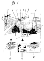
- an aircraft in particular a helicopter 1, is provided for detecting topography data and information, such as, for example, building 7 or high-voltage lines 6, from the air.
- This helicopter 1 is equipped with a position detection system 2, for example for GPS 5 (Global Position System) or the Glonass system.
- an optoelectronic device in particular a laser scanner 3, is provided in the helicopter 1.
- a data processing system 4, 13 is provided for processing the acquired data.
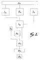
- the data processing system 4, 13 can - as will be shown later - consist of two systems, an on-board computer 4 and a stationary system 13 provided on the ground.
- the position data 2a, the navigation data 8a and the topography data 3a are stored.
- topography data 3a for example the high-voltage line 6, acquired with the laser scanner 3, these position data 2a acquired during the flight are corrected in the data processing 4a.
- navigation data 8a which are generated from an inertial navigation system (INS) 8 also provided in the aircraft, are used.
- INS inertial navigation system
- the generated navigation data 8a from the INS 8 are the acceleration, the velocity, the angular acceleration, the spatial position or the distance traveled by the aircraft over ground or in absolute space. If one associates these navigation data 8a with the position data 2a recorded during the flight, the actual flight path data 14a is already very close. In order to obtain the real, actual flight path data or position data 15a, including the helicopter 1 in space, these are processed with GPS reference point data 9a to the highly accurate flight path position data 15a.
- an evaluation 10a takes place in accordance with the requirements.
- the evaluation 10 may be in a high accuracy 3D point cloud. From this 3D point cloud, a highly accurate and precise 3D model can then be created. Of course it is also possible to use only the numerical values for an evaluation 10.
- a flight guidance program 11a is prepared in advance.
- a digital elevation model (DHM) of the area to be surveyed is generated from the available topography data, for example from the NASA data available on the Internet with a resolution of three latitude or one longitude seconds.
- this DHM is created in rectangular HITS (highway in the sky) and these individual HITS are recorded in a sequence (tunnel in the sky) to the flight operator during the acquisition process, possibly via HUD (headup display) or a head-mounted display.
- HUD headup display
- This procedure serves to maintain a largely constant altitude over ground during the detection process.
- As an optimal altitude with a helicopter 1 have crystallized 100-300 m above ground. With a surface aircraft, the altitudes can be up to 4,000 m. Even from this height excellent evaluations 10 are still possible.
- the speed (to ground speed) of the aircraft is kept constant, this speed being specified by the position detection device 2, that is to say via the GPS / Glonass 5.
- the acquired data such as position data, navigation data and possibly camera data
- a time stamp is advantageously derived from the GPS 5, which has an atomic clock.
- the flight guidance program 11a also assumes position data 2a or navigation data 8a for the location determination during the acquisition flight.
- the above-mentioned method can proceed in different variants, the result being unaffected thereby.
- the data recorded in the helicopter 1, such as position data 2a, navigation data 8a and topography data 3a are stored in respective memories and processed after landing together according to the above steps.
- Another possibility is that, for example, only the position data 2a and the navigation data 8a are linked during the flight and a plausibility check is carried out by the operator via a visualization via data logging. Thus, a statement about quality and, if necessary, quantity can be made during the registration flight.
- a device consisting of components in a means of transportation is provided.
- a device exemplified below in a helicopter 1 has brought optimal results.
- the helicopter 1 is a two-turbine, multi-blade, preferably a four-blade helicopter 1, with the antenna for the GPS 5 or GLONASS being provided on the nose of the helicopter 1.
- a redundant power supply is optionally provided with at least one backup battery.
- the laser scanner 3 and the INS 8 are arranged in a tube with recesses for the laser beam.
- This tube is rotatable coaxially in another tube.
- This device is preferably mounted on the helicopter 1. Such a device has proved to be ideal when the laser scanner 3 for the detection of steeply inclined Areas such as mountain slopes o. The like. Is used. With this configuration, the laser scanner 3 can be pivoted, the INS 8 also detects these spatial positions.
- the laser scanner 3 preferably has a pulse frequency of 80 kHz and records in particular in real time and in particular in the WGS 84 format and has an adjustable opening angle.
- the laser scanner 3 is arranged in the loading space of the helicopter 1.
- the parameterization or calibration of the laser scanner 3 takes place via a calibration measuring field with methods of pattern recognition and / or stochastics.
- the basic equipment of the device can be extended. It is certainly advantageous if a video, infrared or digital camera 12 is provided for topographies of, for example, a spatial planning.
- a corona camera When detecting high-voltage lines 6, the provision of a corona camera is expedient. Another addition in the course of detection of high voltage lines 6 is a temperature sensing device. The temperature can be evaluated via provided on the high voltage line 6 temperature measuring strip.
- the means of transportation is not limited to aircraft such as helicopters 1, airplanes or airships.
- the device for detecting topography data 3a and information may also be arranged on railways for detecting tunnels or ships for detecting grottos or the like.
Landscapes
- Engineering & Computer Science (AREA)
- Radar, Positioning & Navigation (AREA)
- Remote Sensing (AREA)
- Physics & Mathematics (AREA)
- General Physics & Mathematics (AREA)
- Automation & Control Theory (AREA)
- Multimedia (AREA)
- Optical Radar Systems And Details Thereof (AREA)
- Position Fixing By Use Of Radio Waves (AREA)
- Navigation (AREA)
Abstract
Description
Die Erfindung betrifft ein Verfahren zur Erfassung von Topographiedaten und -informationen mit einem eine optoelektronische Einrichtung, insbesondere einen Laserscanner, aufweisenden Fortbewegungsmittel, vorzugsweise Fluggerät und das Fluggerät weiters mit einem Positionserfassungssystem, beispielsweise GPS (Global Position System) oder Glonass System, und einer Datenverarbeitungsanlage versehen ist, wobei die mit der optoelektronischen Einrichtung erfassten Topographiedaten mit den vom Positionserfassungssystem erfassten Positionsdaten in der Datenverarbeitungsanlage verknüpft werden und in einem Speicher der Datenverarbeitungsanlage für eine weitere Auswertung gespeichert werden. Ferner betrifft die Erfindung auch eine Einrichtung zur Durchführung des Verfahrens.The invention relates to a method for recording topography data and information with a optoelectronic device, in particular a laser scanner, having means of transport, preferably aircraft and the aircraft further provided with a position detection system, such as GPS (Global Position System) or Glonass system, and a data processing system wherein the topography data acquired with the optoelectronic device is linked to the position data acquired by the position detection system in the data processing system and stored in a memory of the data processing system for further evaluation. Furthermore, the invention also relates to a device for carrying out the method.
Die Erfassung der Oberflächenbeschaffenheit und die Vermessung der Erdoberfläche haben sich in den letzten Jahren durch den Einsatz von Satellitennavigation, hoch auflösender Digitalfotografie und Laserscanner grundlegend geändert. Waren früher Theodolit und die Berechnung von Polygonzügen das Werkzeug zum Vermessen, ist es heute die Erfassung durch Fotografieren und Laserscanning vom Satellit oder aus dem Flugzeug.Surface texture mapping and earth surface surveying have changed radically in recent years through the use of satellite navigation, high resolution digital photography and laser scanners. In the past, theodolite and the calculation of polygons were the tool for surveying, but today it is the acquisition by photographing and laser scanning from satellite or aircraft.
Über den aktuellen Stand der Technik bei der Erfassung der Erdoberfläche kann sich jeder selbst über das Internet ein Bild machen. Da gibt es neben den "Webcams" ein kostenloses Service, mit dem man sich jedes Objekt auf der Erdoberfläche auf dem Bildschirm abbilden lassen kann. Es gibt zwar unterschiedlich große Auflösungen der Bilder und damit der Größe der darauf noch identifizierbaren Objekte, wie etwa Gebäude, Strassen oder Fahrzeuge - die Städte sind wesentlich genauer, als ländliche Gebiete - aber die Genauigkeit z. B. der amerikanischen Städte, wie New York oder Boston ist so groß, dass man problemlos unterscheiden kann, ob die abgebildeten Fahrzeuge in den Straßen Lkws oder Pkws sind.Everyone can get an idea of the state of the art in capturing the Earth's surface via the Internet. In addition to the "Webcams", there is a free service that allows you to display every object on the surface of the earth on the screen. Although there are different resolutions of the images and thus the size of the still identifiable objects, such as buildings, roads or vehicles - the cities are much more accurate than rural areas - but the accuracy z. As the American cities, such as New York or Boston is so large that you can easily distinguish whether the imaged vehicles in the streets of trucks or cars are.
Wenn man jetzt noch davon ausgeht, dass die Militärs über Datenmaterial verfügen, das noch wesentlich genauer ist und zusätzlich alles in Echtzeit verfolgen können, wird abschätzbar wie leistungsfähig die Erfassung der Oberflächenbeschaffenheit und die Vermessung der Erdoberfläche zur Zeit bereits ist.If one now assumes that the military have data that is much more accurate and can also track everything in real time, it is possible to estimate how efficient it is at the moment to record the surface condition and measure the earth's surface.
Trotzdem ist die Abbildung der Erdoberfläche und der darauf befindlichen Objekte für ganz bestimmte Aufgaben noch zu ungenau.Nevertheless, the mapping of the Earth's surface and its objects is still too imprecise for very specific tasks.
Die Aufgabe der Erfindung liegt darin, ein Verfahren der eingangs genannten Art zu schaffen, das einerseits die Nachteile der oben aufgezeigten Verfahren vermeidet und das anderseits eine hochpräzise, vollständige, dreidimensionale Darstellung der Topographie in wirtschaftlicher Weise ermöglicht.The object of the invention is to provide a method of the type mentioned, on the one hand avoids the disadvantages of the above-indicated method and on the other hand allows a high-precision, complete, three-dimensional representation of the topography in an economical manner.
Die Aufgabe wird durch die Erfindung gelöst.The object is achieved by the invention.
Das erfindungsgemäße Verfahren ist dadurch gekennzeichnet, dass die Positionsdaten vor der Verknüpfung mit den Topographiedaten mit Navigationsdaten des Fluggerätes, die aus einem Inertial-Navigationssystem (INS) des Fortbewegungsmittels, insbesondere des Fluggerätes generiert werden, verknüpft werden. Mit der Erfindung ist es erstmals möglich, während der Bewegung die realen, tatsächlichen Positionsdaten des Fortbewegungsmittels, also insbesondere des Fluggerätes, zu erfassen. Nur mit diesen Positionsdaten resultiert aus der Verknüpfung mit den Topographiedaten eine hochgenaue, umfassende, exakte Erfassung von beispielsweise komplexen Objekten oder Bereichen. In Hinblick auf verschiedene Anwendungsgebiete können dadurch aussagefähige Dokumentationen erstellt werden, die Kontrollen ermöglichen, die die Sicherheit entsprechend den heutigen Anforderungen gewährleisten. Die verschiedenen Anwendungsgebiete sind - nur beispielhaft aufgezeigt - Hochspannungsfreileitungen, Gebäude an exponentiellen Orten, Landschaften in Hinblick Hochwasser oder Lawinen, Eisenbahnunterbau o. dgl.The method according to the invention is characterized in that the position data are linked to navigation data of the aircraft which are generated from an inertial navigation system (INS) of the means of locomotion, in particular of the aircraft, prior to linking with the topographical data. With the invention, it is for the first time possible during the movement to detect the real, actual position data of the means of locomotion, that is to say in particular of the aircraft. Only with these position data does the combination with the topography data result in a highly accurate, comprehensive, exact detection of, for example, complex objects or areas. With regard to various fields of application, this makes it possible to produce meaningful documentation that enables controls that ensure safety in accordance with today's requirements. The various fields of application are - only shown by way of example - high-voltage overhead lines, buildings in exponential places, landscapes in terms of flood or avalanches, railway substructure o. The like.
Für nachfolgende Anforderungen ist eine Erfassung und Abbildung der jeweiligen Topografie mit einer sehr hohen Genauigkeit erforderlich:
- die Dokumentation von Gebäudekomplexen oder Industrieanlagen
- die genaue Erfassung des Verlaufs von Strassen- und Eisenbahntrassen
- die Überwachung von Hochspannungsleitungen
- die Ermittlung des Wasserrückhaltevermögens von Uferlandschaften bei Hochwasser
- die Beurteilung der Gefahr von Lawinenabgängen.
- the documentation of building complexes or industrial plants
- the exact recording of the course of road and rail routes
- the monitoring of high voltage power lines
- the determination of the water retention capacity of shore landscapes during floods
- the assessment of the danger of avalanches.
Insbesondere den Planern, Errichtern und Haltern von Infrastruktureinrichtungen wie Straßenbauten, Lärmschutzeinrichtungen, Leitungsnetzen, Eisenbahnlinien und Pipelines hilft die Erfindung in einer bisher nicht möglichen Präzision und Wirtschaftlichkeit den steigenden Anforderungen gerecht zu werden.In particular, the planners, installers and owners of infrastructure facilities such as road construction, noise abatement, mains networks, railway lines and pipelines, the invention helps in a hitherto impossible precision and efficiency to meet the increasing demands.
Ein wesentlicher Vorteil dieser Erfindung ist das rasche Erfassen von großen Datenmengen. Diese Daten können entsprechend den Anforderungen als Punktwolke, als 3D-Modell oder als Zahlenwerte für eine weitere Auswertung zu Verfügung gestellt werden. Natürlich sind auch mit der Erfindung skalierbare Auswertungen, das heißt entweder in höchster Genauigkeit mit einer 2 cm-Genauigkeit oder in definierter Auflösung, möglich.An essential advantage of this invention is the rapid acquisition of large amounts of data. These data can be provided according to the requirements as a point cloud, as a 3D model or as numerical values for further evaluation. Of course, with the invention scalable evaluations, that is either in the highest accuracy with a 2 cm accuracy or in a defined resolution, possible.
Wie ja an sich bekannt, helfen 3D-Darstellungen komplexe Daten zu verstehen und erleichtern bzw. beschleunigen Entscheidungsvorgänge. Ebenso erleichtern 3D-Darstellungen die Akzeptanz in den betroffenen Kreisen. Interaktive 3D-Animationen und Simulationen sind natürlich ebenfalls möglich.As is well known, 3D representations help to understand complex data and facilitate or accelerate decision making. Similarly, 3D representations facilitate acceptance in the affected circles. Of course, interactive 3D animations and simulations are also possible.
Nach einem besonderen Merkmal der Erfindung sind die generierten Navigationsdaten die Beschleunigung, die Geschwindigkeit, die Winkelbeschleunigung, die Raumposition oder die vom Fluggerät zurückgelegte Distanz über Grund oder im absoluten Raum. Wie ja an sich bekannt, beruht die Inertialnavigation auf dem Prinzip der Integration gemessener Beschleunigungen und Drehungen zur Bestimmung von Lagewinken, Geschwindigkeit und Position im Raum. Mit diesen Navigationsdaten des Fortbewegungsmittels werden die GPS bzw. GLONASS Daten, die auf Grund verschiedener Gegebenheiten, wie Veränderungen der Satellitenumlaufbahn bzw. Wetter, nicht exakt sind, prozessiert bzw. korrigiert.According to a particular feature of the invention, the generated navigation data is the acceleration, the speed, the angular acceleration, the spatial position or the distance traveled by the aircraft over ground or in absolute space. As is well known, inertial navigation is based on the principle of integration of measured accelerations and rotations to determine position wave, velocity and position in the room. With these navigation data of the means of transport, the GPS or GLONASS data, which are not exact due to various circumstances, such as changes in the satellite orbit or weather, processed or corrected.
Gemäß einer Ausgestaltung der Erfindung wird die Erfassung der Topographiedaten mit einer Flughöhe von 100 bis 4 000 m, insbesondere von 100 - 300 m, über Grund durchgeführt. Der Vorteil dieser Ausgestaltung liegt darin, dass einerseits eine geringe Laserleistung für den Scannvorgang erforderlich ist und anderseits auch der Laserstrahlwinkel klein gehalten werden kann. Eine präzise Erfassung ist damit gewährleistet.According to one embodiment of the invention, the detection of the topography data with an altitude of 100 to 4,000 m, in particular from 100 to 300 m, carried out over ground. The advantage of this embodiment is that on the one hand, a low laser power is required for the scanning process and on the other hand, the laser beam angle can be kept small. A precise detection is guaranteed.
Nach einem ganz besonderen Merkmal der Erfindung wird vor dem Überfliegen zur Erfassung der Topographiedaten das zu erfassende Gebiet in einem Flugführungsprogramm aufbereitet. Der Vorteil dieses Merkmals liegt darin, dass eine rationelle und wirtschaftliche Erfassung der Daten durchgeführt werden kann.According to a very special feature of the invention, the area to be detected is prepared in a flight guidance program before flying over to capture the topography data. The advantage of this feature is that a rational and economical acquisition of the data can be performed.
Gemäß einer besonderen Weiterbildung der Erfindung wird ein digitales Höhenmodell (DHM) des zu erfassenden Gebietes aus den verfügbaren Topographiedaten, beispielsweise aus den im Internet verfügbaren NASA-Daten mit einer Auflösung von drei Breiten- bzw. Längensekunden, erstellt, wobei dieses DHM für eine Einhaltung einer weitgehend konstanten Flughöhe über Grund während des Erfassungsvorganges dient. Die Einhaltung einer konstanten Flughöhe über Grund bringt den Vorteil mit sich, dass der Laserstrahl-Scannbereich ebenfalls relativ konstant gehalten werden kann. Der Fehlerbereich wird dadurch stark beschränkt bzw. minimiert.According to a particular development of the invention, a digital elevation model (DHM) of the area to be recorded is created from the available topographical data, for example from the NASA data available on the Internet with a resolution of three width or length seconds, this DHM for compliance a largely constant altitude above ground during the detection process is used. Maintaining a constant altitude over ground has the advantage that the laser beam scanning range can also be kept relatively constant. The error range is severely limited or minimized.
Nach einer besonderen Ausgestaltung der Erfindung wird dieses DHM in rechteckigen HITS (highway in the sky) erstellt und diese einzelnen HITS werden in einer Abfolge (tunnel in the sky) dem Fluggerätführer während des Erfassungsvorganges, gegebenenfalls über HUD (headup display) oder ein Head-Mounted Display, eingespielt. Dadurch wird sichergestellt, dass der Fluggerätführer in einfachster Weise seine vorher festgelegte Flugroute auch beibehalten kann.According to a particular embodiment of the invention, this DHM is generated in rectangular HITS (highway in the sky) and these individual HITS are displayed in a sequence (tunnel in the sky) to the flight operator during the registration process, possibly via HUD (headup display) or a headset. Mounted display, recorded. This will ensure that the In the simplest way, the flight operator can also maintain his predefined flight route.
Gemäß einer weiteren Ausgestaltung der Erfindung wird während der Erfassung der Topographiedaten die Geschwindigkeit (to ground speed) des Fluggerätes konstant gehalten, wobei diese Geschwindigkeit vom Positionserfassungsgerät vorgegeben wird. Auch die weitgehende Konstanthaltung der Geschwindigkeit trägt zur Fehlerminimierung bei.According to a further embodiment of the invention, the speed (to ground speed) of the aircraft is kept constant during the acquisition of the topography data, this speed being predetermined by the position detection device. Also, keeping the speed largely constant contributes to error minimization.
Nach einem besonderen Merkmal der Erfindung werden die während der Erfassung der Topographiedaten erfassten Positionsdaten von GPS/GLONASS über, aus dem INS stammende, Korrekturfaktoren auf die für die Erfassung der Topographiedaten tatsächliche Flugstrecke und Fluggerätlage im Raum errechnet. Die prozessierten, korrigierten GPS/GLONASS-Positionsdaten werden mit den INS-Daten zu den hochgenauen Flugwegdaten prozessiert. Dadurch werden die laufend mit Fehler behafteten Positionsdaten aus dem Flug korrigiert. Erst diese hochgenauen Flugwegdaten geben die reale, tatsächliche Position des Fluggerätes im Zeitpunkt des Laserscannings wieder.According to a particular feature of the invention, the GPS / GLONASS position data acquired during acquisition of the topography data is calculated via correction factors originating from the INS to the actual flight path and aircraft position in space for the acquisition of the topography data. The processed, corrected GPS / GLONASS position data are processed with the INS data for the highly accurate flight path data. As a result, the positional data from the flight that is constantly flawed are corrected. Only these highly accurate flight path data reflect the real, actual position of the aircraft at the time of laser scanning.
Gemäß einer vorteilhaften Weiterbildung der Erfindung werden die während des Erfassungsfluges errechneten tatsächlichen Positionsdaten, insbesondere nach der Landung, mit den GPS-Referenzpunktdaten zu den hochgenauen Flugpositionsdaten prozessiert. Eine weitere Korrektur der erfassten Positionsdaten erfolgt in einem post-processing-Prozess. Wie ja allgemein bekannt, unterliegen auch die GPS/GLONASS Daten nicht der gewünschten Genauigkeit. Um diese Fehlerquellen auszuschalten, die sich auf die Genauigkeit auswirken, wird dieser Rechenvorgang durchgeführt.According to an advantageous development of the invention, the actual position data calculated during the acquisition flight, in particular after landing, are processed with the GPS reference point data to the highly accurate flight position data. A further correction of the detected position data takes place in a post-processing process. As is well known, even the GPS / GLONASS data are not subject to the desired accuracy. To eliminate these sources of error that affect accuracy, this calculation is performed.
Gemäß einer weiteren Ausgestaltung der Erfindung werden diese hochgenauen Flugpositionsdaten, die die Position und die Raumlage des Fluggerätes wiedergeben, nach einer Verknüpfung mit den mit der optoelektronischen Einrichtung erfassten Topographiedaten, insbesondere den Laserscanndaten, zu einer hochgenauen 3D-Punkt-Wolke ausgewertet. Aus dieser 3D Punktwolke kann dann in weiterer Folge ein hochgenaues und präzises 3D-Modell, mit einer 2 cm Genauigkeit in den x/y-Achsen, erstellt werden. Natürlich ist es auch möglich, nur die Zahlenwerte für eine Auswertung heranzuziehen.According to a further embodiment of the invention, these highly accurate flight position data, which reflect the position and the spatial position of the aircraft, are evaluated to a highly accurate 3D point cloud after being linked to the topography data acquired by the optoelectronic device, in particular the laser scanning data. From this 3D point cloud can Subsequently, a highly accurate and accurate 3D model, with a 2 cm accuracy in the x / y axes, can be created. Of course it is also possible to use only the numerical values for an evaluation.
Gemäß einer Weiterbildung der Erfindung werden in der Datenverarbeitungsanlage die von der optoelektronischen Einrichtung erfassten 3D Pixel-Daten über Algorithmen in 3D Vektor-Daten verarbeitet. Mit diesen 3D Vektor Daten wird dann eine spezifische Auswertung entsprechend den Auftragswünschen durchgeführt.According to one embodiment of the invention, the 3D pixel data acquired by the optoelectronic device are processed in the data processing system via algorithms in 3D vector data. With this 3D vector data, a specific evaluation is then carried out in accordance with the order requests.
Nach einem besonderen Merkmal der Erfindung werden die erfassten Daten, wie beispielsweise Positionsdaten, Navigationsdaten und gegebenenfalls Kameradaten, mit einer, vorzugsweise aus der Positionserfassung abgeleiteten, einheitlichen, Zeitmarkierung versehen. Dadurch können die Daten in der Datenverarbeitungsanlage zusammen geführt werden. Ferner wird dadurch ein eindeutiges Gültigkeitsdatum der erfassten Daten gewährleistet.According to a particular feature of the invention, the acquired data, such as position data, navigation data and possibly camera data, with a, preferably derived from the position detection, uniform, timestamp provided. As a result, the data in the data processing system can be combined. It also ensures a clear date of validity of the collected data.
Nach einer Ausgestaltung der Erfindung wird in der Datenverarbeitungsanlage über Datenlogging eine Plausibilitätskontrolle durchgeführt. Dadurch können einzelne Fehlerpunkte der Punktwolke, so genannte Ausreißer, aus dem Ergebnis eliminiert werden.According to one embodiment of the invention, a plausibility check is carried out in the data processing system via data logging. As a result, individual points of the point cloud, so-called outliers, can be eliminated from the result.
Es ist aber auch Aufgabe der Erfindung eine Einrichtung zur Durchführung des Verfahrens zu schaffen, die ebenfalls eine hohe Wirtschaftlichkeit gewährleistet.It is also an object of the invention to provide a device for carrying out the method, which also ensures high efficiency.
Die Aufgabe wird durch die erfindungsgemäße Einrichtung gelöst.The object is achieved by the device according to the invention.
Die Einrichtung zur Erfassung von Topographiedaten und -informationen ist ein eine optoelektronische Einrichtung, insbesondere einen Laserscanner, aufweisendes Fortbewegungsmittel, vorzugsweise ein Fluggerät, wobei das Fluggerät weiters mit einem Positionserfassungssystem, beispielsweise GPS (Global Position System) oder Glonass System, und einer Datenverarbeitungsanlage, insbesondere ein Datenspeicher, versehen ist. Die erfindungsgemäße Einrichtung ist dadurch gekennzeichnet, dass im Fluggerät ein Inertial-Navigationssystem (INS) vorgesehen ist. Mit dieser erfindungsgemäßen Einrichtung ist es erstmals möglich die Topographiedaten und -informationen mit einer äußerst hohen Dokumentationsgenauigkeit zu erfassen, d.h. die Daten werden vollständig, direkt, wirtschaftlich und mit höchster Genauigkeit erfasst. Fehler die auf fehlerhaften Positionsdaten beruhen, werden substituiert. Die Ergebnisse können verschiedenartig sicher dokumentiert und dargestellt werden - wie zum Beispiel als Grundriss, Schnittzeichnung, 3D Modell, photorealistische Animation oder Panoramabild.The device for recording topography data and information is an optoelectronic device, in particular a laser scanner, having means of transport, preferably an aircraft, wherein the aircraft further with a position detection system, such as GPS (Global Position System) or Glonass system, and a Data processing system, in particular a data memory is provided. The device according to the invention is characterized in that an inertial navigation system (INS) is provided in the aircraft. With this device according to the invention, it is possible for the first time to record the topography data and information with extremely high documentation accuracy, ie the data is acquired completely, directly, economically and with the highest accuracy. Errors based on incorrect position data are substituted. The results can be reliably documented and displayed in various ways - such as floor plans, sectional drawings, 3D models, photorealistic animation or panoramic images.
Gemäß einer Weiterbildung der Erfindung ist im Fluggerät eine Kamera, vorzugsweise eine Videokamera und/oder Digitalkamera, vorgesehen. Dadurch können in vorteilhafterweise die in der Datenverarbeitungsanlage erstellten Daten noch besser dokumentiert werden.According to one embodiment of the invention, a camera, preferably a video camera and / or digital camera, is provided in the aircraft. As a result, the data created in the data processing system can advantageously be documented even better.
Nach einer weiteren besonderen Ausgestaltung der Erfindung ist im Fluggerät eine Coronakamera vorgesehen. Mit der Coronakamera können Unregelmäßigkeiten der Leiteroberfläche, die zum Bruch einzelner Drahtlitzen und in weiterer Folge zum Riss der Leitung führen, delektiert werden. Insbesondere den Energieversorgungsunternehmen hilft die Erfindung in einer bisher nicht mögliche Präzision und Wirtschaftlichkeit, ihre Freileitungsnetz zu überwachen und zu dokumentieren, um den jeweiligen Kunden eine optimale Sicherheit und Leistungsfähigkeit zu garantieren und so den ständig steigenden Ansprüchen gerecht zu werden.According to another particular embodiment of the invention, a corona camera is provided in the aircraft. With the corona camera irregularities of the conductor surface, which lead to the breakage of individual wire strands and subsequently to the crack of the line, can be detected. In particular, the power companies, the invention helps in a hitherto impossible precision and efficiency to monitor their overhead line and document in order to guarantee the respective customer optimal safety and performance and so to meet the ever-increasing demands.
Gemäß einer alternativen Ausgestaltung der Erfindung ist im Fluggerät eine Infrarotkamera vorgesehen. Damit können im Zusammenwirken mit den Topographiedaten hochpräzise Thermoprofile erstellt werden.According to an alternative embodiment of the invention, an infrared camera is provided in the aircraft. Thus, in conjunction with the topography data, high-precision thermal profiles can be created.
Nach einer ganz besonderen Ausgestaltung der Erfindung ist im Fluggerät eine Gasspürsensorik vorgesehen. Insbesondere beim Erfassen von Pipelinetrassen kann in Zusammenhang mit einer Gasspürsensorik die Dichtheit der Pipelines bzw. mögliche undichte Stellen in kürzester Zeit geortet werden.According to a very particular embodiment of the invention, a gas detection sensor is provided in the aircraft. In particular, when detecting pipeline routes Can be located in connection with a Gasspürsensorik the tightness of the pipelines or potential leaks in no time.
In einer weiteren alternativen Ausgestaltung der Erfindung ist ein Temperaturerfassungsgerät vorgesehen. Zur Erstellung von Thermobildern ist ein Temperaturmessgerät von Vorteil.In a further alternative embodiment of the invention, a temperature detection device is provided. To create thermal images, a temperature measuring device is an advantage.
Gemäß einer besonderen Ausgestaltung der Erfindung ist im Fluggerät eine redundante Stromversorgung gegebenenfalls mit mindestens einer Pufferbatterie vorgesehen. Diese Ausgestaltung ist in Hinblick auf eine sichere Funktionalität und der Betriebssicherheit der Einrichtung von Vorteil.According to a particular embodiment of the invention, a redundant power supply is optionally provided in the aircraft with at least one backup battery. This embodiment is in terms of safe functionality and reliability of the device advantage.
Nach einem besonderen Merkmal der Erfindung ist das Fluggerät ein Hubschrauber, insbesondere ein Zwei-Turbinen, Mehr-Blatt-, vorzugsweise ein Vier-Blatt-Hubschrauber. Mit einem derartigen Fluggerät können die gestellten Anforderungen an Genauigkeit und Wirtschaftlichkeit problemlos erfüllt werden.According to a particular feature of the invention, the aircraft is a helicopter, in particular a two-turbine, multi-blade, preferably a four-blade helicopter. With such an aircraft, the requirements placed on accuracy and economy can be easily met.
Gemäß einer weiteren Ausgestaltung der Erfindung ist die Antenne für das GPS oder GLONASS auf der Nase des Fluggerätes vorgesehen. Dadurch ist der Vorteil gegeben, dass die entsprechenden Signale mit hoher Qualität erfasst werden. Nach einer Weiterbildung der Erfindung ist die optoelektronische Einrichtung ein Laserscanner, der vorzugsweise eine Pulsfrequenz von 80 kHz aufweist und insbesondere in Echtzeit und insbesondere im WGS 84 Format aufzeichnet. Dadurch werden hochgenaue, präzise Auswertungen rationell möglich.According to a further embodiment of the invention, the antenna for the GPS or GLONASS is provided on the nose of the aircraft. This provides the advantage that the corresponding signals are detected with high quality. According to a development of the invention, the optoelectronic device is a laser scanner which preferably has a pulse frequency of 80 kHz and in particular records in real time and in particular in the WGS 84 format. As a result, highly accurate, precise evaluations are rationally possible.
Gemäß einem weiteren besonderen Merkmal der Erfindung weist der Laserscanner einen einstellbaren Öffnungswinkel auf. Dadurch ist der Vorteil gegeben, dass der Laserstrahl den Anwendungen entsprechend angepasst werden kann.According to a further special feature of the invention, the laser scanner has an adjustable opening angle. This provides the advantage that the laser beam can be adapted to the applications accordingly.
Nach einer Weiterbildung der Erfindung ist die optoelektronische Einrichtung im Laderaum des Fluggerätes angeordnet. Insbesondere bei einem Hubschrauber ist damit eine einfache Aufrüstung gewährleistet.According to a development of the invention, the optoelectronic device is arranged in the cargo compartment of the aircraft. Especially with a helicopter so a simple upgrade is guaranteed.
Gemäß einem weiteren besonderen Merkmal der Erfindung erfolgt die Parametrierung bzw. Kalibrierung der optoelektronischen Einrichtung über ein Kalibrierungsmessfeld mit Methoden der Mustererkennung und/oder Stochastik. Dadurch wird die Parametrierung bzw. Kalibrierung in einfachster Weise durchgeführt.According to a further special feature of the invention, the parameterization or calibration of the optoelectronic device takes place via a calibration measuring field with methods of pattern recognition and / or stochastics. As a result, the parameterization or calibration is carried out in the simplest way.
Entsprechend einer Alternative der Erfindung ist das Fortbewegungsmittel ein Flächenflugzeug, ein Tragschrauber oder ein Luftschiff. Damit ist der Vorteil gegeben, dass großflächige Gebiete in kürzester Zeit topographisch erfasst werden können.According to an alternative of the invention, the means of locomotion is a surface aircraft, a gyroplane or an airship. This provides the advantage that large areas can be recorded topographically in a very short time.
Einer weiteren Alternative der Erfindung entsprechend ist das Fortbewegungsmittel eine Eisenbahn. Damit können hochgenaue Tunnelprofile erstellt werden und kleinste Bewegungen im Gestein in einfacher und wirtschaftlicher Weise frühzeitig erkannt werden. Es liegt durchaus auch im Bereich der Erfindung Tunnel-Topographien zu erstellen.According to a further alternative of the invention, the means of locomotion is a railway. This makes it possible to create highly accurate tunnel profiles and to detect small movements in the rock in a simple and economical way at an early stage. It is also quite within the scope of the invention to create tunnel topographies.
Eine abschließende Alternative der Erfindung ist es, dass das Fortbewegungsmittel ein Fahrzeug zu Land oder Wasser, insbesondere ein Schiff, ist. Dadurch kann das Profil von Grotten oder unterirdische Flüsse und Karstquellen wirtschaftlich erfasst werden.A final alternative of the invention is that the means of transportation is a vehicle to land or water, in particular a ship. This allows the profile of caves or underground rivers and karst springs to be recorded economically.
Nach einem besonderen Merkmal der Erfindung sind der Laserscanner und das INS auf einer Achse gemeinsam drehbar angeordnet, wobei die Drehachse durch die Zentren des Laserscanners und des INS geht. Eine derartige Vorrichtung hat sich als ideal erwiesen, wenn der Laserscanner für die Erfassung von stark geneigten Flächen, wie Berghänge o. dgl. eingesetzt wird. Durch diese Ausgestaltung kann der Laserscanner verschwenkt werden, wobei das INS auch diese Raumlagen erfasst.According to a particular feature of the invention, the laser scanner and the INS are rotatably mounted together on an axis, wherein the axis of rotation passes through the centers of the laser scanner and the INS. Such a device has proven to be ideal when the laser scanner for the detection of steeply inclined surfaces, such as mountain slopes o. The like. Is used. By this configuration, the laser scanner can be pivoted, wherein the INS also detects these spatial positions.
Entsprechend einer besonderen Ausgestaltung der Erfindung ist der Laserscanner und das INS in einem Rohr mit Aussparungen für den Laserstrahl angeordnet, wobei dieses Rohr in einem weiteren Rohr, das ebenfall Ausschnitte für den Laserstrahl aufweist, koaxial drehbar ist und diese Vorrichtung vorzugsweise am Hubschrauber montiert ist. Mit dieser einfachen Vorrichtung können die stark geneigten Flächen in einfachster Weise erfasst werden. Diese Ausgestaltung ist eine äußerst wirtschaftliche Lösung.According to a particular embodiment of the invention, the laser scanner and the INS is arranged in a tube with recesses for the laser beam, said tube in a further tube, the ebenfalls cutouts for the Having laser beam is rotatable coaxially and this device is preferably mounted on the helicopter. With this simple device, the steeply inclined surfaces can be detected in the simplest way. This embodiment is an extremely economical solution.
Die Erfindung wird an Hand von Ausführungsbeispielen, die in der Zeichnung dargestellt sind, näher erläutert.The invention will be explained in more detail with reference to exemplary embodiments, which are illustrated in the drawing.
Es zeigen:
- Fig. 1 eine schematische Darstellung zur Erfassung von Topographiedaten und -informationen,
- Fig. 2 ein schematischer Ablauf des Verfahrens.
- 1 shows a schematic representation for the acquisition of topography data and information,
- Fig. 2 is a schematic flow of the method.
Gemäß der Fig. 1 ist zur Erfassung von Topographiedaten und -informationen, wie beispielsweise Gebäude 7 oder Hochspannungsleitungen 6, aus der Luft ein Fluggerät, insbesondere ein Hubschrauber 1, vorgesehen. Dieser Hubschrauber 1 ist mit einem Positionserfassungssystem 2, beispielsweise für GPS 5 (Global Position System) oder das Glonass System, ausgestattet. Ferner ist in dem Hubschrauber 1 eine optoelektronische Einrichtung, insbesondere ein Laserscanner 3, vorgesehen. Zur Verarbeitung der erfassten Daten ist eine Datenverarbeitungsanlage 4, 13 vorgesehen. Die Datenverarbeitungsanlage 4, 13 kann - wie später noch aufgezeigt wird - aus zwei Anlagen, einem Bordrechner 4 und einer am Boden vorgesehenen stationären Anlage 13 bestehen.According to FIG. 1, an aircraft, in particular a helicopter 1, is provided for detecting topography data and information, such as, for example, building 7 or high-
In weiterer Folge wird zur Fig. 1 auf den schematischen Verfahrensablauf der einzelnen Daten gemäß Fig. 2 verwiesen. Die aus den einzelnen Komponenten stammenden Daten werden mit dem Kleinbuchstaben a bezeichnet.1, reference is made to the schematic process sequence of the individual data according to FIG. 2. The data coming from the individual components are designated by the lowercase letter a.
Wie ja an sich bekannt, weichen die während des Fluges mit dem Positionserfassungssystem 2 erfassten Positionsdaten 2a, beispielsweise vom GPS 5, zumindest nach einiger Flugzeit, von den realen, tatsächlichen Flugwegdaten ab.As is known per se, the position data 2a recorded during the flight with the
In der Datenverarbeitung 4a werden die Positionsdaten 2a, die Navigationsdaten 8a und die Topographiedaten 3a, insbesondere jeder Datensatz für sich, gespeichert.In the data processing 4a, the position data 2a, the navigation data 8a and the topography data 3a, in particular each data record per se, are stored.
Um nun zu einem hoch exakten Ergebnis der mit dem Laserscanner 3 erfassten Topographiedaten 3a, beispielsweise der Hochspannungsleitung 6, zu kommen, werden diese während des Fluges erfassten Positionsdaten 2a in der Datenverarbeitung 4a korrigiert. Zur Korrektur werden Navigationsdaten 8a, die aus einem, ebenfalls im Fluggerät vorgesehenen Inertial-Navigationssystem (INS) 8 generiert werden, verwendet.In order to arrive at a highly exact result of the topography data 3a, for example the high-
Die generierten Navigationsdaten 8a aus dem INS 8 sind die Beschleunigung, die Geschwindigkeit, die Winkelbeschleunigung, die Raumposition oder die vom Fluggerät zurückgelegte Distanz über Grund oder im absoluten Raum. Verknüpft man diese Navigationsdaten 8a mit den während des Fluges erfassten Positionsdaten 2a, so kommt man den tatsächlichen Flugwegdaten 14a schon sehr nahe. Um nun die realen, tatsächlichen Flugwegdaten bzw. Positionsdaten 15a, auch des Hubschraubers 1 im Raum, zu erhalten, werden diese mit GPS-Referenzpunktdaten 9a zu den hochgenauen Flugwegpositionsdaten 15a prozessiert.The generated navigation data 8a from the
Erst diese hochgenauen Flugwegpositionsdaten 15a werden mit den erfassten Topographiedaten aus dem Laserscanner 3 in einer Datenverarbeitungsanlage 13 verknüpft. In der Datenverarbeitungsanlage 13 werden auch die von der optoelektronischen Einrichtung erfassten 3D Pixel-Daten über Algorithmen in 3D Vektor-Daten 16a verarbeitet.Only these highly accurate flight path position data 15a are linked to the acquired topography data from the laser scanner 3 in a
Nach dieser Datenverknüpfung erfolgt eine Auswertung 10a entsprechend den gestellten Anforderungen. Die Auswertung 10 kann in einer hochgenauen 3D-Punkt-Wolke sein. Aus dieser 3D Punktwolke kann dann in weiterer Folge ein hochgenaues und präzises 3D-Modell erstellt werden. Natürlich ist es auch möglich, nur die Zahlenwerte für eine Auswertung 10 heranzuziehen.After this data connection, an
Um nun für ein gewünschtes Gebiet, sei es beispielsweise ein Raumordnungsgebiet oder eine Hochspannungsleitung 6, einen rationellen Erfassungsvorgang zu erhalten, wird im Vorfeld ein Flugführungsprogramm 11 a erstellt. Es wird ein digitales Höhenmodell (DHM) des zu erfassenden Gebietes aus den verfügbaren Topographiedaten, beispielsweise aus den im Internet verfügbaren NASA-Daten mit einer Auflösung von drei Breiten- bzw. Längensekunden, erstellt. Weiters wird dieses DHM in rechteckigen HITS (highway in the sky) erstellt und diese einzelnen HITS werden in einer Abfolge (tunnel in the sky) dem Fluggerätführer während des Erfassungsvorganges, gegebenenfalls über HUD (headup display) oder ein Head-Mounted Display, eingespielt. Diese Vorgangsweise dient für eine Einhaltung einer weitgehend konstanten Flughöhe über Grund während des Erfassungsvorganges. Als eine optimale Flughöhe mit einem Hubschrauber 1 haben sich 100-300 m über Grund heraus kristallisiert. Mit einem Flächenflieger können die Flughöhen bis 4 000 m betragen. Auch aus dieser Höhe sind noch exzellente Auswertungen 10 möglich.In order to obtain a rational detection process for a desired area, be it a spatial planning area or a high-
Ferner wird während der Erfassung der Topographiedaten 3a die Geschwindigkeit (to ground speed) des Fluggerätes konstant gehalten, wobei diese Geschwindigkeit vom Positionserfassungsgerät 2, also über das GPS/Glonass 5, vorgegeben wird.Furthermore, during the acquisition of the topography data 3a, the speed (to ground speed) of the aircraft is kept constant, this speed being specified by the
Sowohl die konstante Flughöhe, wie auch die konstante Fluggeschwindigkeit tragen zur Erhaltung eines hoch exakten Ergebnisses bei. Um eine hoch genaue Datenzusammenführung zu gewährleisten, werden die erfassten Daten, wie beispielsweise Positionsdaten, Navigationsdaten und gegebenenfalls Kameradaten, mit einer, vorzugsweise aus der Positionserfassung abgeleiteten, einheitlichen Zeitmarkierung versehen. Diese Zeitmarkierung wird in vorteilhafterweise vom GPS 5, das über eine Atomuhr verfügt, abgeleitet.Both the constant altitude and the constant airspeed contribute to maintaining a highly accurate result. In order to ensure a highly accurate data combination, the acquired data, such as position data, navigation data and possibly camera data, provided with a, preferably derived from the position detection, uniform time tag. This time stamp is advantageously derived from the
Das Flugführungsprogramm 11a übernimmt auch während des Erfassungsfluges Positionsdaten 2a bzw. Navigationsdaten 8a für die Standortbestimmung.The flight guidance program 11a also assumes position data 2a or navigation data 8a for the location determination during the acquisition flight.
Das oben aufgezeigte Verfahren kann in verschiedenen Varianten ablaufen, wobei das Ergebnis dadurch nicht beeinflusst wird.The above-mentioned method can proceed in different variants, the result being unaffected thereby.
In der einfachsten Variante werden die im Hubschrauber 1 erfassten Daten, wie Positionsdaten 2a, Navigationsdaten 8a und Topographiedaten 3a in jeweiligen Speichern abgelegt und nach der Landung miteinander gemäß den obigen Schritten verarbeitet.In the simplest variant, the data recorded in the helicopter 1, such as position data 2a, navigation data 8a and topography data 3a are stored in respective memories and processed after landing together according to the above steps.
Es ist aber durchaus im Bereich der Erfindung, dass die erwähnten Daten unmittelbar während des Fluges verarbeitet werden.However, it is well within the scope of the invention that the data mentioned be processed directly during the flight.
Eine weitere Möglichkeit besteht darin, dass während des Fluges beispielsweise nur die Positionsdaten 2a und die Navigationsdaten 8a verknüpft werden und über Datenlogging eine Plausibilitätskontrolle vom Operator über eine Visualisierung durchgeführt wird. Damit kann schon weitgehenst während des Erfassungsfluges eine Aussage über Qualität und gegebenenfalls Quantität getroffen werden.Another possibility is that, for example, only the position data 2a and the navigation data 8a are linked during the flight and a plausibility check is carried out by the operator via a visualization via data logging. Thus, a statement about quality and, if necessary, quantity can be made during the registration flight.
Zur Durchführung des Verfahrens ist eine Einrichtung bestehend aus Komponenten in einem Fortbewegungsmittel vorgesehen.
Eine nachstehend beispielhaft aufgezeigte Einrichtung in einem Hubschrauber 1 hat optimale Ergebnisse gebracht.To carry out the method, a device consisting of components in a means of transportation is provided.
A device exemplified below in a helicopter 1 has brought optimal results.
Der Hubschrauber1 ist ein Zwei-Turbinen, Mehr-Blatt-, vorzugsweise ein Vier-Blatt-Hubschrauber1, wobei die Antenne für das GPS 5 oder GLONASS auf der Nase des Hubschraubers 1 vorgesehen ist. Im Hubschrauber 1 ist auch eine redundante Stromversorgung gegebenenfalls mit mindestens einer Pufferbatterie vorgesehen.The helicopter 1 is a two-turbine, multi-blade, preferably a four-blade helicopter 1, with the antenna for the
Entsprechend einer besonderen Ausgestaltung ist der Laserscanner 3 und das INS 8 in einem Rohr mit Aussparungen für den Laserstrahl angeordnet. Dieses Rohr ist in einem weiteren Rohr koaxial drehbar. Montiert ist diese Vorrichtung vorzugsweise am Hubschrauber 1. Eine derartige Vorrichtung hat sich als ideal erwiesen, wenn der Laserscanner 3 für die Erfassung von stark geneigten Flächen, wie Berghänge o. dgl. eingesetzt wird. Durch diese Ausgestaltung kann der Laserscanner 3 verschwenkt werden, wobei das INS 8 auch diese Raumlagen erfasst.According to a particular embodiment, the laser scanner 3 and the
Der Laserscanner 3 weist vorzugsweise eine Pulsfrequenz von 80 kHz auf und zeichnet insbesondere in Echtzeit und insbesondere im WGS 84 Format auf und hat einen einstellbaren Öffnungswinkel. Der Laserscanner 3 ist im Laderaum des Hubschraubers 1 angeordnet. Die Parametrierung bzw. Kalibrierung des Laserscanners 3 erfolgt über ein Kalibrierungsmessfeld mit Methoden der Mustererkennung und/oder Stochastik.The laser scanner 3 preferably has a pulse frequency of 80 kHz and records in particular in real time and in particular in the WGS 84 format and has an adjustable opening angle. The laser scanner 3 is arranged in the loading space of the helicopter 1. The parameterization or calibration of the laser scanner 3 takes place via a calibration measuring field with methods of pattern recognition and / or stochastics.
Für verschiedene Anwendungszwecke kann die Grundausstattung der Einrichtung erweitert werden. So ist es sicher von Vorteil, wenn für Topographien beispielsweise einer Raumordnung eine Video-, Infrarot- oder eine Digitalkamera 12 vorgesehen wird.For different purposes, the basic equipment of the device can be extended. It is certainly advantageous if a video, infrared or
Bei der Erfassung von Hochspannungsleitungen 6 ist das Vorsehen einer Coronakamera zweckmäßig. Eine weitere Ergänzung im Zuge der Erfassung von Hochspannungsleitungen 6 ist ein Temperaturerfassungsgerät. Die Temperatur kann über an der Hochspannungsleitung 6 vorgesehene Temperaturmessstreifen ausgewertet werden.When detecting high-
Es liegt durchaus im Bereich der Erfindung, dass entlang einer Pipeline Gasaustritte mit einer Gasspürsensorik detektiert werden.It is well within the scope of the invention that along a pipeline gas leaks are detected with a Gasspürsensorik.
Natürlich ist das Fortbewegungsmittel nicht auf Fluggeräte, wie Hubschrauber 1, Flächenflieger oder Luftschiffe begrenzt. Die Einrichtung zur Erfassung von Topographiedaten 3a und -informationen kann natürlich auch auf Eisenbahnen zum Detektieren von Tunneln oder Schiffen zum Erfassen von Grotten o. dgl. angeordnet werden.Of course, the means of transportation is not limited to aircraft such as helicopters 1, airplanes or airships. Of course, the device for detecting topography data 3a and information may also be arranged on railways for detecting tunnels or ships for detecting grottos or the like.
Denkbar für spezielle Aufgaben sind auch Sonderfahrzeuge zu Land.Also conceivable for special tasks are special vehicles by land.
Claims (31)
Applications Claiming Priority (1)
| Application Number | Priority Date | Filing Date | Title |
|---|---|---|---|
| AT0040006A AT503449B1 (en) | 2006-03-10 | 2006-03-10 | METHOD OF RECORDING TOPOGRAPHIC DATA |
Publications (1)
| Publication Number | Publication Date |
|---|---|
| EP1832840A1 true EP1832840A1 (en) | 2007-09-12 |
Family
ID=38055305
Family Applications (1)
| Application Number | Title | Priority Date | Filing Date |
|---|---|---|---|
| EP07004751A Withdrawn EP1832840A1 (en) | 2006-03-10 | 2007-03-08 | Method for recording topography data |
Country Status (2)
| Country | Link |
|---|---|
| EP (1) | EP1832840A1 (en) |
| AT (1) | AT503449B1 (en) |
Cited By (4)
| Publication number | Priority date | Publication date | Assignee | Title |
|---|---|---|---|---|
| CN103353297A (en) * | 2013-06-03 | 2013-10-16 | 长春理工大学 | Airborne photoelectric measurement apparatus of dimensions and spacing of electric transmission line and target, and method thereof |
| CN107194827A (en) * | 2017-05-22 | 2017-09-22 | 上海华测导航技术股份有限公司 | A kind of electric power networks management method |
| CN108957473A (en) * | 2017-05-22 | 2018-12-07 | 上海华测导航技术股份有限公司 | A kind of electric power networks management system |
| DE102019204749A1 (en) * | 2019-04-03 | 2020-03-19 | Thyssenkrupp Ag | Process and device for the automated operation of a material extraction system that can be used primarily in opencast mining |
Families Citing this family (1)
| Publication number | Priority date | Publication date | Assignee | Title |
|---|---|---|---|---|
| DE102011103850B4 (en) * | 2011-05-26 | 2016-09-29 | Deutsches Zentrum für Luft- und Raumfahrt e.V. | Method for the quantitative determination of uncontrolled release of radioactive isotopes in cosmic ray fields |
Citations (8)
| Publication number | Priority date | Publication date | Assignee | Title |
|---|---|---|---|---|
| DE2818531C2 (en) * | 1977-05-31 | 1988-08-04 | Franz Plasser Bahnbaumaschinen-Industriegesellschaft M.B.H., Wien, At | |
| US20020060784A1 (en) * | 2000-07-19 | 2002-05-23 | Utah State University | 3D multispectral lidar |
| US6438270B1 (en) * | 1999-03-03 | 2002-08-20 | Xerox Corporation | Methods and systems for image sharpening |
| US20040130702A1 (en) * | 2001-02-09 | 2004-07-08 | Jupp David L | Lidar system and method |
| US20040169844A1 (en) * | 2003-01-06 | 2004-09-02 | Kwo-Jyr Wong | Aerial vehicle speed error correlation method for two-dimensional visual reproduction of laser radar imaging |
| US20040183696A1 (en) * | 2003-03-17 | 2004-09-23 | Sri International | Heads-up display for propeller-driven aircraft |
| US20050177307A1 (en) * | 2002-05-30 | 2005-08-11 | Rafael-Armament Development Authority Ltd | Airborne reconnaissance system |
| US20050273254A1 (en) * | 2003-03-02 | 2005-12-08 | Tomer Malchi | Passive target data acquisition method and system |
Family Cites Families (3)
| Publication number | Priority date | Publication date | Assignee | Title |
|---|---|---|---|---|
| US5557397A (en) * | 1994-09-21 | 1996-09-17 | Airborne Remote Mapping, Inc. | Aircraft-based topographical data collection and processing system |
| AUPR575701A0 (en) * | 2001-06-18 | 2001-07-12 | Bhp Billiton Innovation Pty Ltd | Gravity surveys |
| US7365544B2 (en) * | 2001-10-11 | 2008-04-29 | Bhp Billiton Innovation Pty Ltd. | Methods of adjusting airborne geophysical measurements based on mapping instrument measurements |
-
2006
- 2006-03-10 AT AT0040006A patent/AT503449B1/en not_active IP Right Cessation
-
2007
- 2007-03-08 EP EP07004751A patent/EP1832840A1/en not_active Withdrawn
Patent Citations (8)
| Publication number | Priority date | Publication date | Assignee | Title |
|---|---|---|---|---|
| DE2818531C2 (en) * | 1977-05-31 | 1988-08-04 | Franz Plasser Bahnbaumaschinen-Industriegesellschaft M.B.H., Wien, At | |
| US6438270B1 (en) * | 1999-03-03 | 2002-08-20 | Xerox Corporation | Methods and systems for image sharpening |
| US20020060784A1 (en) * | 2000-07-19 | 2002-05-23 | Utah State University | 3D multispectral lidar |
| US20040130702A1 (en) * | 2001-02-09 | 2004-07-08 | Jupp David L | Lidar system and method |
| US20050177307A1 (en) * | 2002-05-30 | 2005-08-11 | Rafael-Armament Development Authority Ltd | Airborne reconnaissance system |
| US20040169844A1 (en) * | 2003-01-06 | 2004-09-02 | Kwo-Jyr Wong | Aerial vehicle speed error correlation method for two-dimensional visual reproduction of laser radar imaging |
| US20050273254A1 (en) * | 2003-03-02 | 2005-12-08 | Tomer Malchi | Passive target data acquisition method and system |
| US20040183696A1 (en) * | 2003-03-17 | 2004-09-23 | Sri International | Heads-up display for propeller-driven aircraft |
Non-Patent Citations (1)
| Title |
|---|
| YUDAYA SIVATHANU ET AL.: "A cost Effective Multi_Spectral Scanner for Naturel Gas Detection", SEMI-ANNUAL PROGRESS REPORT NO. 1, April 2004 (2004-04-01), XP002436478, Retrieved from the Internet <URL:http://www.osti.gov/bridge/servlets/purl/823777-UdARK2/native/823777.pdf> [retrieved on 200706] * |
Cited By (4)
| Publication number | Priority date | Publication date | Assignee | Title |
|---|---|---|---|---|
| CN103353297A (en) * | 2013-06-03 | 2013-10-16 | 长春理工大学 | Airborne photoelectric measurement apparatus of dimensions and spacing of electric transmission line and target, and method thereof |
| CN107194827A (en) * | 2017-05-22 | 2017-09-22 | 上海华测导航技术股份有限公司 | A kind of electric power networks management method |
| CN108957473A (en) * | 2017-05-22 | 2018-12-07 | 上海华测导航技术股份有限公司 | A kind of electric power networks management system |
| DE102019204749A1 (en) * | 2019-04-03 | 2020-03-19 | Thyssenkrupp Ag | Process and device for the automated operation of a material extraction system that can be used primarily in opencast mining |
Also Published As
| Publication number | Publication date |
|---|---|
| AT503449A4 (en) | 2007-10-15 |
| AT503449B1 (en) | 2007-10-15 |
Similar Documents
| Publication | Publication Date | Title |
|---|---|---|
| Evtiukov et al. | Smart transport in road transport infrastructure | |
| US9823664B2 (en) | Unmanned aircraft for positioning an instrument for inspection purposes and methods of inspecting a target surface | |
| US11818625B2 (en) | Sensitive area management | |
| CN109901624A (en) | A kind of bridge method for inspecting | |
| EP3049825B1 (en) | Determination of the position of a vehicle on or above a planet surface | |
| CN109945874B (en) | Bridge inspection route planning method | |
| DE102011119762A1 (en) | Positioning system for motor vehicle, has processing unit that determines localized position of vehicle using vehicle movement data measured based on specific location data stored in digital card | |
| US20130176424A1 (en) | Complete remote sensing bridge investigation system | |
| CN109901625A (en) | A kind of bridge cruising inspection system | |
| EP3066419A1 (en) | Method and system for producing a vector map | |
| JP2012511697A (en) | How to generate a geodetic reference database | |
| EP3400415B1 (en) | Overburden thickness measurement | |
| CN109901623B (en) | Method for planning inspection route of pier body of bridge | |
| DE60121944T2 (en) | METHOD AND DEVICE FOR DISPLAYING NAVIGATION INFORMATION IN REAL-TIME OPERATION | |
| AT503449B1 (en) | METHOD OF RECORDING TOPOGRAPHIC DATA | |
| US20170359525A1 (en) | Complete remote sensing bridge investigation system | |
| Kim et al. | Applicability assessment of UAV mapping for disaster damage investigation in Korea | |
| Lee et al. | Calibration of a UAV based low altitude multi-sensor photogrammetric system | |
| DE102016007182A1 (en) | System and method for determining and storing location-related problem areas Navigation satellite-supported position determination | |
| EP0652448A2 (en) | Method for image enhanced position detection and cartography of subterranean objects | |
| TWI787488B (en) | Method of evaluating degradation in property of mobile, apparatus of evaluating degradation in property of mobile, method of preparing property-degradation-rate-map and apparatus of preparing property-degradation-rate-map | |
| DE102018205142A1 (en) | Method for detecting a current position of a motor vehicle, device for carrying out the method and motor vehicle | |
| CHIFAN et al. | UAV PHOTOGRAMMETRY IMPLEMENTATION TO ENHANCE LAND SURVEYING IN CADASTER | |
| CN116859986A (en) | Unmanned aerial vehicle route planning method for existing railway banded region | |
| Karasaka et al. | An Overview of Terrestrial Mobile Mapping Systems: The Example of the Topcon IP-S2 |
Legal Events
| Date | Code | Title | Description |
|---|---|---|---|
| PUAI | Public reference made under article 153(3) epc to a published international application that has entered the european phase |
Free format text: ORIGINAL CODE: 0009012 |
|
| AK | Designated contracting states |
Kind code of ref document: A1 Designated state(s): AT BE BG CH CY CZ DE DK EE ES FI FR GB GR HU IE IS IT LI LT LU LV MC MT NL PL PT RO SE SI SK TR |
|
| AX | Request for extension of the european patent |
Extension state: AL BA HR MK YU |
|
| STAA | Information on the status of an ep patent application or granted ep patent |
Free format text: STATUS: THE APPLICATION HAS BEEN WITHDRAWN |
|
| 18W | Application withdrawn |
Effective date: 20080311 |