CN110896660A - Handheld device for economic agriculture management - Google Patents
Handheld device for economic agriculture management Download PDFInfo
- Publication number
- CN110896660A CN110896660A CN201880052691.6A CN201880052691A CN110896660A CN 110896660 A CN110896660 A CN 110896660A CN 201880052691 A CN201880052691 A CN 201880052691A CN 110896660 A CN110896660 A CN 110896660A
- Authority
- CN
- China
- Prior art keywords
- crop
- information
- field
- economic
- agricultural
- Prior art date
- Legal status (The legal status is an assumption and is not a legal conclusion. Google has not performed a legal analysis and makes no representation as to the accuracy of the status listed.)
- Pending
Links
- 238000012545 processing Methods 0.000 claims abstract description 28
- 238000000034 method Methods 0.000 claims description 30
- 238000003306 harvesting Methods 0.000 claims description 23
- 239000000575 pesticide Substances 0.000 claims description 20
- 239000003337 fertilizer Substances 0.000 claims description 18
- 239000004009 herbicide Substances 0.000 claims description 18
- 238000004590 computer program Methods 0.000 claims description 16
- 230000033001 locomotion Effects 0.000 claims description 15
- 238000007726 management method Methods 0.000 description 42
- 241000196324 Embryophyta Species 0.000 description 27
- 241000607479 Yersinia pestis Species 0.000 description 27
- 240000003768 Solanum lycopersicum Species 0.000 description 23
- 239000000047 product Substances 0.000 description 23
- 235000007688 Lycopersicon esculentum Nutrition 0.000 description 21
- 201000010099 disease Diseases 0.000 description 17
- 208000037265 diseases, disorders, signs and symptoms Diseases 0.000 description 17
- 238000009313 farming Methods 0.000 description 17
- 239000002689 soil Substances 0.000 description 8
- 230000009471 action Effects 0.000 description 6
- 230000008901 benefit Effects 0.000 description 6
- 230000012010 growth Effects 0.000 description 6
- 230000008569 process Effects 0.000 description 6
- 239000008358 core component Substances 0.000 description 5
- 235000013399 edible fruits Nutrition 0.000 description 5
- 239000002917 insecticide Substances 0.000 description 5
- 238000013528 artificial neural network Methods 0.000 description 3
- 239000000306 component Substances 0.000 description 3
- 238000013481 data capture Methods 0.000 description 3
- 230000035784 germination Effects 0.000 description 3
- 230000002363 herbicidal effect Effects 0.000 description 3
- 230000003993 interaction Effects 0.000 description 3
- 238000010899 nucleation Methods 0.000 description 3
- 238000009331 sowing Methods 0.000 description 3
- 230000003115 biocidal effect Effects 0.000 description 2
- 239000003139 biocide Substances 0.000 description 2
- 230000005540 biological transmission Effects 0.000 description 2
- 239000002131 composite material Substances 0.000 description 2
- 230000002596 correlated effect Effects 0.000 description 2
- 230000001419 dependent effect Effects 0.000 description 2
- 230000000694 effects Effects 0.000 description 2
- 230000006870 function Effects 0.000 description 2
- 238000010801 machine learning Methods 0.000 description 2
- 230000000246 remedial effect Effects 0.000 description 2
- 230000004044 response Effects 0.000 description 2
- 239000007921 spray Substances 0.000 description 2
- 208000024891 symptom Diseases 0.000 description 2
- 238000002054 transplantation Methods 0.000 description 2
- 230000009105 vegetative growth Effects 0.000 description 2
- XLYOFNOQVPJJNP-UHFFFAOYSA-N water Substances O XLYOFNOQVPJJNP-UHFFFAOYSA-N 0.000 description 2
- 230000003936 working memory Effects 0.000 description 2
- FGUUSXIOTUKUDN-IBGZPJMESA-N C1(=CC=CC=C1)N1C2=C(NC([C@H](C1)NC=1OC(=NN=1)C1=CC=CC=C1)=O)C=CC=C2 Chemical compound C1(=CC=CC=C1)N1C2=C(NC([C@H](C1)NC=1OC(=NN=1)C1=CC=CC=C1)=O)C=CC=C2 FGUUSXIOTUKUDN-IBGZPJMESA-N 0.000 description 1
- 241000238631 Hexapoda Species 0.000 description 1
- 244000141359 Malus pumila Species 0.000 description 1
- 241000233622 Phytophthora infestans Species 0.000 description 1
- 241000201976 Polycarpon Species 0.000 description 1
- 239000008186 active pharmaceutical agent Substances 0.000 description 1
- 230000009418 agronomic effect Effects 0.000 description 1
- 238000004458 analytical method Methods 0.000 description 1
- 235000021016 apples Nutrition 0.000 description 1
- 238000003339 best practice Methods 0.000 description 1
- 230000008859 change Effects 0.000 description 1
- 239000003086 colorant Substances 0.000 description 1
- 230000001276 controlling effect Effects 0.000 description 1
- 230000003111 delayed effect Effects 0.000 description 1
- 238000003708 edge detection Methods 0.000 description 1
- 239000012467 final product Substances 0.000 description 1
- 230000000855 fungicidal effect Effects 0.000 description 1
- 239000000417 fungicide Substances 0.000 description 1
- 230000036541 health Effects 0.000 description 1
- 238000010191 image analysis Methods 0.000 description 1
- 238000011835 investigation Methods 0.000 description 1
- 238000004519 manufacturing process Methods 0.000 description 1
- 230000015654 memory Effects 0.000 description 1
- 238000009308 mixed farming Methods 0.000 description 1
- 235000003715 nutritional status Nutrition 0.000 description 1
- 230000003287 optical effect Effects 0.000 description 1
- 230000000737 periodic effect Effects 0.000 description 1
- 238000013439 planning Methods 0.000 description 1
- 238000012794 pre-harvesting Methods 0.000 description 1
- 238000002360 preparation method Methods 0.000 description 1
- 230000001932 seasonal effect Effects 0.000 description 1
- 238000003860 storage Methods 0.000 description 1
- 230000002195 synergetic effect Effects 0.000 description 1
- 238000012549 training Methods 0.000 description 1
- 238000012384 transportation and delivery Methods 0.000 description 1
- 230000001960 triggered effect Effects 0.000 description 1
- 230000001755 vocal effect Effects 0.000 description 1
- 238000009333 weeding Methods 0.000 description 1
Images


Classifications
-
- G—PHYSICS
- G06—COMPUTING; CALCULATING OR COUNTING
- G06Q—INFORMATION AND COMMUNICATION TECHNOLOGY [ICT] SPECIALLY ADAPTED FOR ADMINISTRATIVE, COMMERCIAL, FINANCIAL, MANAGERIAL OR SUPERVISORY PURPOSES; SYSTEMS OR METHODS SPECIALLY ADAPTED FOR ADMINISTRATIVE, COMMERCIAL, FINANCIAL, MANAGERIAL OR SUPERVISORY PURPOSES, NOT OTHERWISE PROVIDED FOR
- G06Q10/00—Administration; Management
- G06Q10/06—Resources, workflows, human or project management; Enterprise or organisation planning; Enterprise or organisation modelling
- G06Q10/063—Operations research, analysis or management
-
- A—HUMAN NECESSITIES
- A01—AGRICULTURE; FORESTRY; ANIMAL HUSBANDRY; HUNTING; TRAPPING; FISHING
- A01B—SOIL WORKING IN AGRICULTURE OR FORESTRY; PARTS, DETAILS, OR ACCESSORIES OF AGRICULTURAL MACHINES OR IMPLEMENTS, IN GENERAL
- A01B69/00—Steering of agricultural machines or implements; Guiding agricultural machines or implements on a desired track
- A01B69/007—Steering or guiding of agricultural vehicles, e.g. steering of the tractor to keep the plough in the furrow
- A01B69/008—Steering or guiding of agricultural vehicles, e.g. steering of the tractor to keep the plough in the furrow automatic
-
- A—HUMAN NECESSITIES
- A01—AGRICULTURE; FORESTRY; ANIMAL HUSBANDRY; HUNTING; TRAPPING; FISHING
- A01B—SOIL WORKING IN AGRICULTURE OR FORESTRY; PARTS, DETAILS, OR ACCESSORIES OF AGRICULTURAL MACHINES OR IMPLEMENTS, IN GENERAL
- A01B79/00—Methods for working soil
-
- A—HUMAN NECESSITIES
- A01—AGRICULTURE; FORESTRY; ANIMAL HUSBANDRY; HUNTING; TRAPPING; FISHING
- A01B—SOIL WORKING IN AGRICULTURE OR FORESTRY; PARTS, DETAILS, OR ACCESSORIES OF AGRICULTURAL MACHINES OR IMPLEMENTS, IN GENERAL
- A01B79/00—Methods for working soil
- A01B79/005—Precision agriculture
-
- A—HUMAN NECESSITIES
- A01—AGRICULTURE; FORESTRY; ANIMAL HUSBANDRY; HUNTING; TRAPPING; FISHING
- A01B—SOIL WORKING IN AGRICULTURE OR FORESTRY; PARTS, DETAILS, OR ACCESSORIES OF AGRICULTURAL MACHINES OR IMPLEMENTS, IN GENERAL
- A01B79/00—Methods for working soil
- A01B79/02—Methods for working soil combined with other agricultural processing, e.g. fertilising, planting
-
- A—HUMAN NECESSITIES
- A01—AGRICULTURE; FORESTRY; ANIMAL HUSBANDRY; HUNTING; TRAPPING; FISHING
- A01C—PLANTING; SOWING; FERTILISING
- A01C1/00—Apparatus, or methods of use thereof, for testing or treating seed, roots, or the like, prior to sowing or planting
-
- A—HUMAN NECESSITIES
- A01—AGRICULTURE; FORESTRY; ANIMAL HUSBANDRY; HUNTING; TRAPPING; FISHING
- A01C—PLANTING; SOWING; FERTILISING
- A01C21/00—Methods of fertilising, sowing or planting
- A01C21/007—Determining fertilization requirements
-
- A—HUMAN NECESSITIES
- A01—AGRICULTURE; FORESTRY; ANIMAL HUSBANDRY; HUNTING; TRAPPING; FISHING
- A01C—PLANTING; SOWING; FERTILISING
- A01C7/00—Sowing
-
- A—HUMAN NECESSITIES
- A01—AGRICULTURE; FORESTRY; ANIMAL HUSBANDRY; HUNTING; TRAPPING; FISHING
- A01D—HARVESTING; MOWING
- A01D75/00—Accessories for harvesters or mowers
-
- A—HUMAN NECESSITIES
- A01—AGRICULTURE; FORESTRY; ANIMAL HUSBANDRY; HUNTING; TRAPPING; FISHING
- A01G—HORTICULTURE; CULTIVATION OF VEGETABLES, FLOWERS, RICE, FRUIT, VINES, HOPS OR SEAWEED; FORESTRY; WATERING
- A01G22/00—Cultivation of specific crops or plants not otherwise provided for
-
- A—HUMAN NECESSITIES
- A01—AGRICULTURE; FORESTRY; ANIMAL HUSBANDRY; HUNTING; TRAPPING; FISHING
- A01G—HORTICULTURE; CULTIVATION OF VEGETABLES, FLOWERS, RICE, FRUIT, VINES, HOPS OR SEAWEED; FORESTRY; WATERING
- A01G25/00—Watering gardens, fields, sports grounds or the like
- A01G25/16—Control of watering
-
- A—HUMAN NECESSITIES
- A01—AGRICULTURE; FORESTRY; ANIMAL HUSBANDRY; HUNTING; TRAPPING; FISHING
- A01M—CATCHING, TRAPPING OR SCARING OF ANIMALS; APPARATUS FOR THE DESTRUCTION OF NOXIOUS ANIMALS OR NOXIOUS PLANTS
- A01M21/00—Apparatus for the destruction of unwanted vegetation, e.g. weeds
- A01M21/04—Apparatus for destruction by steam, chemicals, burning, or electricity
- A01M21/043—Apparatus for destruction by steam, chemicals, burning, or electricity by chemicals
-
- A—HUMAN NECESSITIES
- A01—AGRICULTURE; FORESTRY; ANIMAL HUSBANDRY; HUNTING; TRAPPING; FISHING
- A01M—CATCHING, TRAPPING OR SCARING OF ANIMALS; APPARATUS FOR THE DESTRUCTION OF NOXIOUS ANIMALS OR NOXIOUS PLANTS
- A01M7/00—Special adaptations or arrangements of liquid-spraying apparatus for purposes covered by this subclass
- A01M7/0089—Regulating or controlling systems
-
- G—PHYSICS
- G01—MEASURING; TESTING
- G01S—RADIO DIRECTION-FINDING; RADIO NAVIGATION; DETERMINING DISTANCE OR VELOCITY BY USE OF RADIO WAVES; LOCATING OR PRESENCE-DETECTING BY USE OF THE REFLECTION OR RERADIATION OF RADIO WAVES; ANALOGOUS ARRANGEMENTS USING OTHER WAVES
- G01S19/00—Satellite radio beacon positioning systems; Determining position, velocity or attitude using signals transmitted by such systems
- G01S19/01—Satellite radio beacon positioning systems transmitting time-stamped messages, e.g. GPS [Global Positioning System], GLONASS [Global Orbiting Navigation Satellite System] or GALILEO
- G01S19/13—Receivers
-
- G—PHYSICS
- G01—MEASURING; TESTING
- G01S—RADIO DIRECTION-FINDING; RADIO NAVIGATION; DETERMINING DISTANCE OR VELOCITY BY USE OF RADIO WAVES; LOCATING OR PRESENCE-DETECTING BY USE OF THE REFLECTION OR RERADIATION OF RADIO WAVES; ANALOGOUS ARRANGEMENTS USING OTHER WAVES
- G01S19/00—Satellite radio beacon positioning systems; Determining position, velocity or attitude using signals transmitted by such systems
- G01S19/38—Determining a navigation solution using signals transmitted by a satellite radio beacon positioning system
- G01S19/39—Determining a navigation solution using signals transmitted by a satellite radio beacon positioning system the satellite radio beacon positioning system transmitting time-stamped messages, e.g. GPS [Global Positioning System], GLONASS [Global Orbiting Navigation Satellite System] or GALILEO
- G01S19/42—Determining position
- G01S19/45—Determining position by combining measurements of signals from the satellite radio beacon positioning system with a supplementary measurement
-
- G—PHYSICS
- G06—COMPUTING; CALCULATING OR COUNTING
- G06Q—INFORMATION AND COMMUNICATION TECHNOLOGY [ICT] SPECIALLY ADAPTED FOR ADMINISTRATIVE, COMMERCIAL, FINANCIAL, MANAGERIAL OR SUPERVISORY PURPOSES; SYSTEMS OR METHODS SPECIALLY ADAPTED FOR ADMINISTRATIVE, COMMERCIAL, FINANCIAL, MANAGERIAL OR SUPERVISORY PURPOSES, NOT OTHERWISE PROVIDED FOR
- G06Q30/00—Commerce
- G06Q30/02—Marketing; Price estimation or determination; Fundraising
- G06Q30/0201—Market modelling; Market analysis; Collecting market data
- G06Q30/0206—Price or cost determination based on market factors
-
- G—PHYSICS
- G06—COMPUTING; CALCULATING OR COUNTING
- G06Q—INFORMATION AND COMMUNICATION TECHNOLOGY [ICT] SPECIALLY ADAPTED FOR ADMINISTRATIVE, COMMERCIAL, FINANCIAL, MANAGERIAL OR SUPERVISORY PURPOSES; SYSTEMS OR METHODS SPECIALLY ADAPTED FOR ADMINISTRATIVE, COMMERCIAL, FINANCIAL, MANAGERIAL OR SUPERVISORY PURPOSES, NOT OTHERWISE PROVIDED FOR
- G06Q50/00—Systems or methods specially adapted for specific business sectors, e.g. utilities or tourism
- G06Q50/02—Agriculture; Fishing; Mining
-
- G—PHYSICS
- G06—COMPUTING; CALCULATING OR COUNTING
- G06V—IMAGE OR VIDEO RECOGNITION OR UNDERSTANDING
- G06V20/00—Scenes; Scene-specific elements
- G06V20/10—Terrestrial scenes
- G06V20/188—Vegetation
Abstract
The invention relates to a handheld device for economic agriculture management. It is described to have a user of the device provide (110) agricultural information related to the field, wherein the agricultural information comprises information about at least one crop. A transmitter of the device transmits (120) information including agricultural information relating to the field. A receiver of the device receives (130) agricultural data including economic information related to at least one crop. A processing unit of the device determines (140) economic agriculture management information on the basis of the agricultural data. An output unit of the device outputs (150) the economic agriculture management information to a user of the device.
Description
Technical Field
The present invention relates to a handheld device for economic agriculture management and a method for economic agriculture management using a handheld device, as well as to a computer program element and a computer readable medium.
Background
The general background of the invention is agricultural management. Increasingly sophisticated agricultural management systems are being provided for large agricultural enterprises that operate complex, sometimes automated, machinery within the integrated agricultural management system. However, a large portion of the world's desired grain is produced by small farmers who may have only a small field, or many small fields, and who do not or hardly operate mechanized machinery, and for whom such complex agricultural management systems are inappropriate.
Disclosure of Invention
It would be advantageous to provide agricultural land management tools to assist such small farmers. The object of the invention is solved with the subject matter of the independent claims, wherein further embodiments are incorporated in the dependent claims. It should be noted that the following described aspects and examples of the invention also apply to the handheld device for economic agriculture management, the method for economic agriculture management using the handheld device, and to the computer program element and the computer readable medium.
According to a first aspect, there is provided a handheld device for economic agriculture management, comprising:
-an input unit;
-a processing unit;
-a transmitter;
-a receiver; and
-an output unit.
The input unit is configured to: enabling a user of the device to provide agricultural information relating to the field, wherein the agricultural information includes information about at least one crop. The processing unit is configured to: information including agricultural information relating to the field is transmitted using a transmitter. The processing unit is further configured to: agricultural data is received with the receiver, the agricultural data including economic information related to at least one crop. The processing unit is configured to: and determining economic and agricultural management information on the basis of agricultural data. The output unit is configured to: and outputting economic and agricultural management information to a user of the equipment.
In this way, farmers may not know when to sell a crop, or where to sell the crop, or when to harvest the crop for sale at an optimal time, or for their crop and at what price they can get in anticipation of the amount of production from their field, the farmers may be provided with specific information about such economic issue for the crop that takes into account information about the field in which the crop is being planted or in which the crop is intended to be planted.
In an example, the device includes a GPS unit. The processing unit is configured to: at least one geographic location of the field is determined, the determining including utilization of a GPS unit. The information transmitted by the transmitter may include at least one geographical location of the field.
In this way, a farmer may not necessarily know exactly where his farm or a field in the farm is located and what is the best crop planted at that location in terms of profitability and then where, at what price and when to sell the product, can be provided with relevant economic agriculture recommendations tailored to his location. In other words, a device such as a smartphone may use its GPS unit to determine the location of the smartphone. From this location, economic agriculture advice and/or information may be provided to the farmer via the screen of the smartphone.
In an example, the determination of the at least one geographic location of the field includes at least one movement of the GPS unit. In this way, farmers can move the equipment in order to determine the location of their fields. In an example, the at least one movement comprises movement of the device around at least one boundary of the field. In other words, the farmer may outline the field by positioning the device at the boundary of the field. In an example, the at least one movement comprises movement of the device around all boundaries of the field.
In this manner, farmers can walk or otherwise move around the boundaries of their fields. Thus, not only may the farmer be provided with economic agriculture advice/information that takes into account his location, but the advice/information may also take into account the size of the field. In other words, the farmer may be provided with advice as to which crop to plant and where the crop may sell the best depending on the location of the field, so that information about what crop is growing well at that location is related to information about where the crop may be sold in the area. Furthermore, by knowing the size of the field, the expected crop yield can be taken into account with respect to selling the crop. For example, a field of a particular size at a particular location may be suitable for planting crops A, B, C and D.
However, crop a is usually very profitable but not easily transportable, and in farmer field areas, only markets at a significant distance from the field can purchase the product. For crop B, the crop is usually valuable, but the specific conditions associated with the farmer's field mean that the crop will not grow well. For crop C, the crop is again profitable, but the local market will not be able to purchase all of the farmer crops that must be harvested in a short period of time. However, for crop D, there is a good market in the local area, and in order to avoid overwhelming the local market and underrating the price, farmers need to harvest within weeks. This information can therefore be provided to the farmer to help him select the crop to be planted.
In addition to suggesting which crop to plant, information about the crop being planted may also be provided to the farmer. This may involve the cost of fertilizers, herbicides, pesticides, and the expected price of his crop in local markets, which may take into account temporary fluctuations in price in those markets, prices for different grades or qualities of the crop, the quality or expected quality of its crop. This enables the farmer to determine if it is worthwhile to use fertilizers, herbicides, pesticides, where and when to harvest and sell his products and where. For example, it may be desirable for a farmer product to be harvested and sold tomorrow, but the crop price is relatively low in the local market, and as such, it would be better to wait for a while and sell the crop later, even if there is a slight decrease in its quality.
In an example, the device includes a camera. The camera is configured to enable a user to acquire at least one image relating to at least one crop. The information transmitted by the transmitter may include at least one image relating to at least one crop. In other words, the economic information relating to the at least one crop downloaded onto the device may take into account the actual image relating to the crop being planted. In an example, the at least one image related to the at least one crop includes an image of the at least one crop.
Therefore, the advice (economic agriculture management information) provided to the farmers can take into account how crops look. For example, farmers may take images of tomatoes or of several tomatoes they plant in a field. The image may belong to the best condition tomatoes, average levels of tomatoes, or substandard tomatoes. The farmer may then be provided with the following information: this information is about the price they may expect for their crop, and where and when it will be best to sell the crop.
These images may belong to the best condition tomatoes and may provide the farmer with the following information: this information is that no remedial action is required and they should continue to plant tomatoes in the same manner. However, recommendations based on such images may suggest when it is best for farmers to harvest tomatoes. However, the image of the tomato may indicate: they should be watered, they are suffering from pests and diseases, or they develop worse than they should, for this field in the location and considering when they are planted or sown, and the recommendations for the farmer may be to water the crop and how much water to apply per unit area, to use herbicides and/or pesticides and when and how to apply it, and/or to use fertilizers and when and how to use it.
In an example, the economic information related to the at least one crop includes pricing information related to the at least one crop. In an example, the input unit is configured to enable a user of the device to input a request for information relating to at least one crop. The determination of the economic agricultural management information may then include utilization of the information request relating to the at least one crop.
In this way, the advice provided to the farmer may be related to a particular question or problem that the farmer has. For example, farmers may indicate when they want to sell their crops, for example, they may need income at a particular point in time. In view of this information, the farmer may be advised as to what crop will be the best crop to be sown in order to have a crop ready for harvesting, taking into account the predicted weather at the location and/or detailed information, for example, relating to soil conditions at the field, and what crops are sold in the local market, and whether a good price is available. If a farmer is already planting a particular crop, the advice given to the farmer may again relate to where the crop may be sold and what price is expected to be received. The information provided by farmers may relate only to the specific crop they are growing, the particular market they wish to use, or the market they do not wish to use. Thus, the farmer may be provided with advice tailored to his needs.
The information provided by the farmer may relate to: what economic benefit will be related to the use of fertilizers, herbicides or pesticides. For example, based on information about when a crop is sown, information about where a field is located, and possibly information about soil quality, and information about how the crop is growing (e.g., crop images in terms of plants and/or individual fruits, including a statistical number of such images), the processing unit may determine what the sale price expected at a particular market at a particular harvest time will be in the future, taking into account what the expected crop quality and crop yield at that harvest time will be. The processor determines the cost of applying fertilizer, herbicide and pesticide (or any number of these, including only one) in view of the field size and crop, as well as the predicted expected increase in quality and/or yield, resulting in the ability to predict a new selling price that may be concurrent with or earlier than the previous expected harvest time, where the expected cost can be adjusted by the cost of fertilizer, herbicide, pesticide, etc. In this way, farmers are able to determine what the expected economic return will be with respect to the work they do.
In other words, information about the tomatoes relating to a field may be downloaded into the device on the basis of the information relating to the field and the information about the crop, such as the crop being a tomato, for example taking into account the location of the field, the type of soil in the field, general weather conditions, etc. The processor of the device then uses this information to process the information to provide specific answers to the questions asked by the farmer.
The query posed by the farmer may be processed externally by the device (e.g., at an external server), the specific answer to the query is included in the agricultural data downloaded to the device, and the processor then need only select and present that answer to the farmer.
In an example, the economic agriculture management information includes one or more of: what crop to seed; when to seed the crop; when the crop is harvested; when the crop is sold; where to sell the crop; what price the crop is expected to be; whether to harvest and sell the crop in stages, and then where to sell the harvested crop; how to do to improve the quality and/or yield of the crop and how this has an impact on the expected financial return for the crop; and whether fertilizers, herbicides and/or pesticides are used, and what impact this has on the expected financial return for the crop.
According to a second aspect, there is provided a method for economic agriculture management using a handheld device, comprising:
a) providing, by a user of the device, agricultural information relating to a field, wherein the agricultural information includes information about at least one crop;
c) transmitting information including agricultural information relating to a field using a transmitter of the device;
d) receiving, using a receiver of the device, agricultural data, the agricultural data including economic information related to at least one crop;
e) determining economic agricultural management information based on the agricultural data using a processing unit of the apparatus; and
f) outputting economic agriculture management information to a user of the apparatus using an output unit of the apparatus.
In an example, the apparatus comprises a GPS unit, and wherein step a) comprises determining at least one geographical location of the field, the determining comprising utilization of the GPS unit, and wherein the information transmitted by the transmitter may comprise the at least one geographical location of the field.
In an example, the device comprises a camera, and wherein step a) comprises the user using the camera to acquire at least one image relating to at least one crop, and wherein in step c) the information transmitted by the transmitter may comprise the at least one image relating to at least one crop.
In an example, the method comprises step b): inputting, by a user via an input unit of the device, a request for information relating to at least one crop, and wherein step e) comprises utilizing the request for information relating to at least one crop.
According to another aspect, a computer program element for controlling an apparatus according to the first aspect is provided, which, when being executed by a processor, is configured to perform the method of the second aspect. In an example, a computer-readable medium having stored a program element is provided.
Advantageously, the benefits provided by any of the above aspects apply equally to all other aspects, and vice versa. The above aspects and examples will become apparent from and elucidated with reference to the embodiments described hereinafter.
Drawings
Exemplary embodiments will be described below with reference to the accompanying drawings:
FIG. 1 shows a schematic set-up of an example of a handheld device for economic agriculture management;
FIG. 2 illustrates a method for economic agriculture management using a handheld device;
FIG. 3 shows a schematic set-up of an example of a handheld device operated by a user for economic agriculture management;
FIG. 4 shows a schematic set-up of an example of a handheld device operated by a user for economic agriculture management;
FIG. 5 shows a schematic set-up of an example of a handheld device operated by a user for economic agriculture management;
FIG. 6 shows a schematic set-up of an example of a handheld device operated by a user for economic agriculture management;
FIG. 7 shows a schematic set-up of an example of a handheld device operated by a user for economic agriculture management; and
fig. 8 shows a detailed example of a workflow for providing agricultural management information to farmers.
Detailed Description
Fig. 1 shows an example of a handheld device 10 for economic agriculture management. The device 10 comprises an input unit 20, a processing unit 30, a transmitter 40, a receiver 50 and an output unit 60. The input unit 20 is configured to: enabling a user of the device to provide agricultural information relating to the field. The agricultural information includes information about at least one crop. The processing unit 30 is configured to: information including agricultural information relating to the field is transmitted using the transmitter 40. The processing unit 30 is further configured to: the receiver 50 is utilized to receive agricultural data including economic information related to at least one crop. Then, the processing unit 30 is configured to: and determining economic and agricultural management information on the basis of agricultural data. The output unit 60 is configured to: economic-agricultural management information is output to a user of the device, for example, via a display of the device (such as a display of a smartphone).
According to an example, the device comprises a GPS unit 70. The processing unit is configured to determine at least one geographic location of the field. The determination of the at least one geographic location includes utilization of a GPS unit. The information transmitted by the transmitter may then include at least one geographical location of the field.
In an example, the device is configured to receive a satellite image of the terrain. In this manner, the GPS determined position can also be correlated with the satellite images to determine the extent and boundaries of the farmer's field from the field boundaries observed in the satellite images. In an example, the processing unit is configured to determine the field boundaries using image processing, such as edge detection filters.
In an example, satellite images can be queried to provide farmers with a number of bounded fields, any one or more of which can be their field or fields, based on a general GPS determined location. These may be color coded, for example. These images of the field are then presented to the farmer, for example on the screen of a smartphone. A farmer looking at the fields as if they were located within the satellite image will immediately be able to indicate which of the fields is his field, for example, based on geographical context information such as that his field has a treelet in a corner, or that the field is next to a stream, or next to a triangular field. In case, for example, a smartphone has a touch screen, this can be done by touching the screen at the location where his or her field is located. Potential fields may be presented to farmers in different colors, making it easier to view different fields in the context of structural aspects and surrounding geographic information.
The recommendations for farmers may relate to the following information: such as what crops are planted, how the crops are planted, what herbicides, pesticides or fertilizers are used, when and for what reasons, whether and for what reasons herbicides, pesticides or fertilizers are not needed, when the crops are watered, when the crops are sown and when the crops are harvested. The information provided to the farmer may relate to what diseases are affecting the crop, what pests are affecting the crop, and how to remedy this situation by, for example, applying herbicides or insecticides and when and how they should be applied. The recommendations may relate to when the crop is harvested, how much harvest is in the field to harvest at any time, where and when the crop is sold, and what the expected price is. The cost impact of all these actions related to profit and loss can be presented to the farmer when the farmer eventually sells the product.
According to an example, the determination of the at least one geographic location of the field includes at least one movement of the GPS unit.
According to an example, the at least one movement comprises the apparatus moving around at least one boundary of the field.
According to an example, the at least one movement comprises the device moving around all boundaries of the field.
According to an example, the device comprises a camera 80. The camera 80 is configured to: enabling a user to acquire at least one image relating to at least one crop. The information transmitted by the transmitter may then include at least one image relating to at least one crop.
In an example, the at least one image relating to the at least one crop comprises: an image of the ground or soil in which at least one crop is growing or in which the at least one crop is to be planted. In an example, the at least one image relating to the at least one crop comprises at least a portion of a field. Then, in this example, the determination of the at least one geographic location of the field may include utilization of the at least one image.
In an example, the device is configured to receive satellite images of the terrain, and the processing unit is configured to determine the at least one geographic location using the satellite images and at least one image acquired by a camera of the device. In other words, features in the acquired image may be compared to and/or mapped onto the satellite images in order to augment the GPS information to determine the at least one geographic location.
In an example, the at least one image includes at least one image of at least one boundary of the field.
In an example, the at least one image includes images of all boundaries of the field.
Thus, the exact size and location of the field boundaries can be determined on the basis of the GPS-derived information and the image-derived information. In this manner, bearing errors in the GPS data can be mitigated by the utilization of an entire series of images of the field boundaries. These images can be compared to satellite images to determine the location of the field. Alternatively, as the farmer walks around the field, an entire series of images of the field boundaries may be acquired. These images can be rendered together to form a seamless composite boundary of a field, so that the exact location of the field boundary and the exact size of the field can be determined. As part of this image-based process, a device such as a smartphone may utilize a motion sensor such as an inertial navigation sensor to determine the distance moved between the acquisition of each image. This information can be used to provide the actual size of the composite border rendered from the image of the field border, enabling the exact geographic location of the border to be determined. This may enhance GPS-derived location information.
According to an example, the at least one image relating to the at least one crop comprises an image of the at least one crop. In an example, the at least one image relating to the at least one crop includes an image of weeds and/or pests and/or diseases of the at least one crop. According to an example, the economic information related to the at least one crop includes pricing information related to the at least one crop.
In an example, the pricing information relates to historical pricing information. In an example, the pricing information relates to predicted pricing information. In an example, historical pricing information is utilized to predict pricing information. In an example, weather forecast information is utilized to predict pricing information. In an example, pricing information is predicted using at least one image related to a crop. In an example, the image is related to the growing plant, and thus can be evaluated with respect to the health of the crop, and the expected price that the crop can be obtained at the time of harvest. In an example, the image relates to fruit that is growing, and therefore can be evaluated with respect to an expected price that can be achieved at harvest time. In an example, the at least one image relating to the crop includes a satellite image of an area surrounding the field. In this manner, image analysis can determine which type of crop is being planted in the area. Thus, if a farmer is planting the same crop as other farmers, she may not get as good a price as she would if she were planting a different crop on the surrounding farm. Satellite images over multiple years can be queried to determine what crops were planted in the previous years, and this can be correlated to the prices of different crops in the local market in those same years, and this information can be used with satellite images of fields in that area for that year to better determine the expected price of her crop in the local market when the farmer is selling the crop, and to better determine which market made the product best sold. This information can also be used to suggest to a farmer what crop to plant, in that it is a good decision to plant a crop that other farmers do not plant or appear to not plant, because there may be a premium on such scarce resources when she sells the crop from the local market.
In an example, the economic information related to the at least one crop includes information related to markets in a region of the field. In an example, the economic information related to the at least one crop includes information related to a commercially available crop in a region of the field. In an example, the pricing information relates to historical pricing information on markets in regions of the field. In an example, the economic information related to the at least one crop includes historical information related to an amount of the crop sold on the market in the region of the field.
According to an example, the input unit is configured to enable a user of the device to input a request for information relating to at least one crop. The determination of the economic agricultural management information may then include utilization of the information request relating to the at least one crop.
According to an example, the economic agricultural management information includes one or more of: what crop to seed; when to seed the crop; when the crop is harvested; when the crop is sold; where to sell the crop; what price the crop is expected to be; whether to harvest and sell the crop in stages, and then where to sell the harvested crop; how to do to improve the quality and/or yield of the crop and how this has an impact on the expected financial return for the crop; and whether fertilizers, herbicides and/or pesticides are used, and what impact this has on the expected financial return for the crop.
Fig. 2 shows an example of a method 100 for economic agriculture management using a handheld device in its basic steps. The method 100 comprises:
in a providing step 110 (also referred to as step a)), providing agricultural information relating to the field by a user of the apparatus, wherein the agricultural information comprises information about at least one crop;
in a transmission step 120 (also referred to as step c)), information including agricultural information relating to the field is transmitted using the transmitter of the apparatus;
in a receiving step 130 (also referred to as step d)), receiving agricultural data using a receiver of the apparatus, the agricultural data including economic information relating to at least one crop;
in a determination step 140 (also referred to as step e)), economic agriculture management information is determined on the basis of the agricultural data using a processing unit of the device; and
in the output step 150 (also referred to as step f)), the economic agriculture management information is output to the user of the device using the output unit of the device.
According to an example, the device comprises a GPS unit, and wherein step a) comprises determining at least one geographical location of the field, the determining comprising utilization of the GPS unit. The information transmitted by the transmitter may then include at least one geographical location of the field.
In an example, the determination of the at least one geographic location of the field includes at least one movement of the GPS unit.
In an example, the at least one movement comprises the apparatus moving around at least one boundary of the field.
In an example, the at least one movement includes the device moving around all boundaries of the field.
According to an example, the device comprises a camera, wherein step a) comprises the user using the camera to acquire at least one image relating to at least one crop. In step c), the information transmitted by the transmitter may comprise at least one image relating to at least one crop.
In an example, the at least one image related to the at least one crop includes an image of the at least one crop.
In an example, the economic information related to the at least one crop includes pricing information related to the at least one crop.
According to an example, the method comprises step b): a request for information relating to at least one crop is input 160 by a user via an input unit of the device. Step e) may then comprise the utilization of a request for information relating to at least one crop.
In an example, the economic agriculture management information includes one or more of: what crop to seed; when to seed the crop; when the crop is harvested; when the crop is sold; where to sell the crop; what price the crop is expected to be; whether to harvest and sell the crop in stages, and then where to sell the harvested crop; how to do to improve the quality and/or yield of the crop and how this has an impact on the expected financial return for the crop; and whether fertilizers, herbicides and/or pesticides are used, and what impact this has on the expected financial return for the crop.
Fig. 3 shows an example of how a user may use the device. The user has an App on his smartphone. When requesting a user to define where to find their fields, the user is effectively uncertain. She lives in a rural community with a small field and is planted with different seasonal crops that she sells in one or more local markets. She uses her knowledge gained from success and failure, as well as knowledge gained from neighbors, to grow her crop. However, she believes she can do better and is operating a device as described herein, which in this example is a smartphone running an APP (application). Returning to her question, the device asks her to walk around the boundary of the field, as to where her field will be located. The device also requests: she can take a border image on her course around the field border, but this is not essential. After the operation has been completed, she indicates that she has been completed.
At this point, the mobile phone accesses the remote server via normal telecommunications transmission and downloads the information to the smartphone. The information indicates what crops will be best planted in the field, where such crops are sold, what prices can be obtained for such crops, and information that enables the cost/benefit of using fertilizers, herbicides, pesticides to be determined. Knowing the size of the field, the farmer is provided with information about e.g. how many seeds are needed, which information is presented e.g. on the screen of a mobile phone such as a smart phone. The farmer is also provided with information about what the expected yield of her crop will be and whether the local market will be able to accommodate his harvest at the expected harvest time. The farmer is also provided with information about which market is best used and what price she is expected to receive. If a farmer uploads crop-related information (such as information about the type of soil, the plants being grown, and images of the fruit/crop itself, as well as images showing information about pests and diseases), this information can be used to provide the farmer with more accurate expected pricing information, as well as information about how to alleviate such problems and associated costs and how it may affect the price she can obtain. Thus, the farmer can be provided with information about the cost of using fertilizers, herbicides and pesticides and what effect these will have on the expected selling price. Moreover, if the use of fertilizers, herbicides/pesticides is not required, this information can be provided to the farmer.
Thus, the remote server may provide, based on the user's general location and other information as detailed: information about the type of crop that can be planted and the seed sowing rate per unit area, as well as economic data about selling the product and how best to prepare the product for sale. The processor in the smartphone can then process this downloaded information to provide the farmer with information about the actual amount of seed needed for their field, and where and when to sell the final product.
In addition to what is suggested to be planted, the farmer may indicate the specific crop she is planting and may provide information via a keypad (the keypad of a mobile phone) or take images about other information (such as images of weeds, diseases and pests, images of the crop/fruit itself) and be provided with economic information about the crop, such as where and when and at what price to sell the crop. The information indicated by the farmer is again transmitted to the remote server and the information provided back to the farmer indicates the following information: such as what herbicides or pesticides/insecticides to use, and how and when to use them and the amount needed, and the cost benefits associated with such use in terms of expected price impact. The following information is also provided to the farmer: this information is about what market to use, what the expected selling price is likely to be based on historical information, and the expected quality and yield of her crop when she will harvest-she can again be advised when to harvest, which may not be the most ideal time in terms of the quality of her crop, but it is at the time when a better price is expected to be achieved. In addition to how crops are prepared for sale, and where and when they are sold, and the price that can be expected, this information also specifies when crops are watered and when crops are harvested.
In the case of a smartphone with sufficient memory, rather than using a remote server, the information database maintained on the remote server and the processing to locate the field and determine weeds/pests, determine economic information, etc. would reside on the smartphone itself. In this case, it is not necessary to transmit the information to the remote server, but economic agriculture management information can be provided to farmers even in remote locations without telephone coverage.
Fig. 4 shows a further example of how a farmer may use a handheld device and may proceed from the use illustrated in fig. 3. The order of the pictures shown in fig. 4 is: 1) upper left; 2) left lower; 3) middle and upper mounting; 4) carrying out middle and lower treatment; 5) upper right and 6) lower right. At 1), the farmer has input crops into the apparatus that she has planted in different fields. In fact, this may be the crop she is planning to grow, or indeed, she may seek advice on what crop she is best growing. For example, on the basis of the location and size of her field, the soil quality in her field, weather forecasts for days and possibly weeks in the future, and when she wants to harvest a crop and thus earn some money, she may be provided with recommendations on the crop to plant, as well as information on how to plant and care for that crop, and may be provided with costs associated with different action plans.
Returning, however, to the specific case shown in 1), the farmer has indicated that she is planting tomatoes in one field and apples in a second field. In 2), she has indicated the specific variety of tomatoes planted in field F1, the soil type (which is optional information), and the date of planting. This information is sent to a remote server and data relating to all aspects of agricultural management of this crop is sent to her mobile phone, taking into account the time the crop was sown, the location where her field is located, her field size, and information such as weather forecasts, the types of pests and diseases affecting its crop at that location.
The information downloaded to the phone also relates to the location of local markets, what they sell, pricing information for different products on those markets, and the amount of products that can be sold in a particular market. This information may be considered to form part of the agricultural data and the processor of the smartphone utilizes the data set to drill down queries (drill down) and provide the farmer with specifically tailored information. In fig. 4-3), the farmer has requested information about the general management of his crops and provided information about the nursery management to the farmer (including when and how to apply pesticides), information about the crop transplantation to the farmer, and information about when and how to apply pesticides, and also information about the forecast of heavy rainfall within the next 48 hours to the farmer so that she can plan her actions accordingly. Furthermore, information about vegetative growth is provided. The farmer requests more information about the vegetative growth, wherein the information is provided to the farmer as shown in 4) and 5). After this request, in frames 4) and 5), she is provided with information on how to prepare the land for the tomatoes, information on nursery preparation, seed sowing, germination and transplantation. She is also provided with information about how the crop is looking for weeds as it grows, which is discussed in more detail in fig. 5, and is also provided with specific economic information, which is discussed in more detail with respect to fig. 7.
With continued reference to fig. 4, she was concerned that her crop did not grow as expected and wanted to know if a problem occurred. She asks this through a suitable interaction via the keyboard of her smartphone and, in 6), provides him with more information about the pests and weeds that may affect her crop, based on the location where her field is located, and the time of the year and when she seeds the crop and therefore the expected developmental stage of the crop. The processor in the mobile phone interrogates the initially downloaded information relating to the crop (agricultural data) and the result of this interrogation is a determination of the information presented to the farmer in 6). The farmer could take a photograph of a mature tomato, leaf and whole tomato plant. The processor in the mobile phone then uses image processing, in conjunction with data previously downloaded into the phone, to provide better information to the farmer as to what the problem may be. However, these images may be sent to a remote server and such more customized information determined remotely and then sent to the farmer's mobile phone, thereby enabling the information shown in 6) to be presented to the farmer.
Fig. 5 is a continuation of the frame shown in fig. 4. The order of the pictures shown in fig. 5 is again: 1) upper left; 2) left lower; 3) middle and upper mounting; 4) carrying out middle and lower treatment; 5) the upper right; and 6) bottom right. In fig. 1), after fig. 4-6) relate to what may be the problem, the farmer in fig. 5-1) indicates that she thinks the problem is wilting (damp off). Alternatively, the processor and/or remote server may automatically determine that the problem is wilting and immediately present information to the user as shown in fig. 5-1) rather than the processor presenting information relating to many possibilities as shown in fig. 4-6. The images can be used to determine the problem by a process that utilizes machine learning algorithms, such as neural networks trained using a large number of tomato images at different stages of growth, in different regions of the world and at different times, where the images relate to tomatoes that are not problematic and tomatoes that are affected by different pests and diseases, as well as images of whole plants and leaves that are also at different stages of growth, at different locations in the world, at different times, and affected by different pests and diseases, as well as images of unaffected plants. The training set is a "real data" set because each image is labeled with all relevant information discussed above. The algorithm can then determine the pest/disease or determine that there is no pest/disease problem, but that the crop needs to be watered, based on the image of the fruit and/or leaf. The process may be run without knowledge of the particular crop being used, but may perform better with knowledge of the crop. Also, an image of weeds or an image of pests themselves (e.g., insects) may be taken and a similar analysis is performed using the neural network or a similar neural network to provide information about pests/diseases to farmers. In fact, even without the presented image data, possible problems can be determined using machine learning algorithms based on information provided by the farmer, as presented in fig. 4-6). The processed information is then related to the crop, location, time of year, growth stage, and other non-image based information discussed herein. This non-image information is also utilized when images are present, and enhances image processing in predicting problems that may arise, as seen in fig. 4-6) and 5-1).
Continuing with fig. 5-1), the farmer is presented with information about "wilting", with the following explanation: what the symptom is, and the probability that this is the problem and/or the general likelihood that the problem exists. The farmer requests further information about wilting and in fig. 5-2) information is provided about how the crops in the field are inspected by reconnaissance to confirm that the problem is indeed wilting or indeed any other problem-a disease or pest that has been presented to the farmer as a potential problem. The farmer is also provided with the name of the recommended product that can be used to deal with the problem, and in fig. 5-3) information is provided about how to use the product, when to use the product, and what security measures to take. In fig. 5, in frames 4), 5) and 6), further examples of potential problems that may be presented to farmers on the basis of the information they provide about the crops in the field and about the field itself are shown.
The farmer also requested information about how she should manage tomato crops in her fields, where fig. 6 shows the information presented to the farmer about specific crops in her specific fields. The picture order shown in fig. 6 is: 1) upper left; 2) left lower; 3) the upper right; and 4) bottom right. In images 1), 2) and 3), she is presented with information about the nursery management and when to spray the pesticide, what products she can use and how to use the products. She is provided with information about when to transplant the crop, and when to apply the insecticide, which insecticide can be used, and how to apply the insecticide. Additional information is provided to the farmer such as how often the crop is watered or irrigated, when to fertilize, when it is best to search for (reconnaissance) weeds and disease/pests, and when to fertilize, wherein this information provided to the farmer also takes into account weather forecasts. This means that she will not be advised to do something when the weather conditions will not be suitable for completing the task, but rather the task schedule can be adjusted to an earlier or later date to take into account the predicted weather conditions at the location of her field. Fig. 6-4) show examples of information presented to a farmer about crops in his particular field, which information is provided to the farmer on the basis of information provided to him, and where the processing of this information has indicated that it is best to apply a fungicide on a particular date. The farmer is provided with the product that can be used, the best date on which to spray the biocide, the amount and manner of applying the biocide, and information about the cost per litre of product, thereby enabling the farmer to understand the cost of treatment.
Fig. 7 shows specific economic information provided to farmers. The order of the pictures shown in fig. 7 is again: 1) upper left; 2) left lower; 3) middle and upper mounting; 4) carrying out middle and lower treatment; 5) the upper right; and 6) bottom right. A farmer wants to know where she should sell her crops, where and at what price for the quality of her crops, and whether different crops should be sold using different markets in order to obtain the best price. She also wants to know the costs associated with managing and planting her crops, and how this will affect the selling prices she may obtain, in order to provide her with an understanding of the income she can expect. In 1), she is provided with information about the weather forecast, so that she can determine whether something planned for her crop (watering, weeding, applying fertilizer/herbicide/pesticide, harvesting) should be done as planned, or whether it should be advanced or delayed. In 2), she is provided with the lowest and highest prices she can expect for different crops, and what is the market price for a particular crop that is available. She requests specific information about the tomatoes and in 3) provides her with the prices she can obtain in the different markets, as well as the distances from those markets, thereby enabling her to take into account the transportation costs. In 4), she is also provided with market-specific pricing information as a function of time from which the best time to sell can be determined. Additionally, profit and loss information is given in 5) and 6) that is relevant to her expected return for the particular field in which the particular crop has been planted, and provides her with information regarding what the particular cost is. In this way, a simple, easy to use and accessible device is provided for a farmer to manage and sell her crops, which is particularly suitable for small farmers.
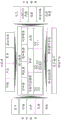
Fig. 8 shows a detailed example of a workflow for providing economic agriculture management information to farmers. A specific example is shown in connection with providing a farming calendar.
In fig. 8, creating a personalized farming calendar involves interaction between several core components, as well as interaction with the content repository, influencing factors, external services and mobile platforms. Providing personalized content delivery (related content at the correct time) is the goal of developing farming calendars. Content related to the farming calendar is stored in an organized manner in a content repository.
Different factors relating to providing a farming calendar will now be discussed:
content library
Crops
This relates to the agronomic growth stage, time and timing of each crop. Crop dynamics influence farming practices. For example: the farming practices followed in the paddy field are different from those required for growing tomatoes.
Product(s)
The product catalog includes product details, such as products from the bayer company. And provides detailed information such as: characteristics, benefits, mode of action, recommended crop, target pest, method of application, pre-harvest interval, and the like.
Pest pests
The pest module comprises a pest name, a symptom caused by the pest, and a control measure recommended by the control measure.
Best practice
Recommended farming practices for profitable farming. These practices include standard practices and custom practices. Standard practice: farmers generally follow farming practices at the particular crop stage. For example, base fertilizer application during the seeding stage. The pitch to be followed during a later stage. Self-defining practice: as a special case of improving farm productivity, farming practices followed by farmers.
Influencing factors refer to external factors that define the settings of crop stage, time and timing.
Influencing factor
Season
The agricultural year is divided into several seasons (spring, summer, fall and winter) which are marked by specific weather patterns that affect the growth cycle of crops and the incidence of pests.
Crops
Crops are plants that are cultivated in fields for commercial purposes. In the case of mixed farming, more than one crop may be planted in the same field. To create a farming calendar, the primary/main crop should be considered. A field may only have one main crop for which a cultivation calendar will be created.
Variety of (IV) C
Self-pollinated varieties or hybrid crops planted by farmers. For example: abhinav, Laxmi in tomato.
Farm
A unit of land on which to plant a crop. This will be a permanent location, area, or coordinates that do not change often. Farmers may have multiple farms.
Field of China
The sub-units of the farm may vary (area) from season to season as the farmer plants different crops. A farm may have a plurality of fields.
The core component is an indispensable component of the cultivation calendar, which controls the lifecycle (from start to end) of the cultivation calendar.
Core assembly
Controller
The controller is a rules engine developed specifically for the purpose of tilling calendars, for example. The controller analyzes data received from external services and interacts with other core components.
Scheduling program
The Spring scheduler (Spring scheduler) initiates the process to gather information from external services, run a rules engine, and identify events that should be sent to the mobile application.
Notification service
The notification service allows the server to send different types of alerts and notifications to the mobile app. To generate the notification, the farming calendar service interacts with an external service.
Synchronization service
The synchronization service enables a user to synchronize data from a server. It will be invoked in a periodic manner (at a pre-scheduled time) or when the state changes (dynamic/real-time). The last successful synchronization timestamp will be used for subsequent state changes between the synchronization server and the app.
If the response is too large to handle in a single response, it will be split into multiple logical parts and will be transferred. The client receives all splits and updates them in the local data store. If the data is not received completely for any reason, it will roll back completely on the client side and a new update request will be initiated during the next execution of the synchronization call.
Crop stage model
The time line of the crop calendar is generated based on the crop phase, time and timing. The standard crop stage defined by the agriculturist will be mapped to the local crop stage that will be shown in the mobile app. The timeline of the crop calendar starts from a specific date (e.g., the seeding date-2017, 9/1) and ends after harvest. The interval between crop stages is timed (e.g., germination takes 10 days after sowing), and the date derived based on the timing will be shown as time (germination starts on 9/10 days 2017).
Event(s)
Events are triggered farming calendar information that will be displayed along the crop stage. Events were classified into 4 categories based on severity.
1. Information-no remedial action needs to be taken, e.g., the farmer is notified when the thing reaches a new growth stage.
2. Alarm/warning-an investigation is conducted to decide if action needs to be taken. For example, an alarm is sent when weather conditions are appropriate for pests and diseases.
3. Input advice-the farmer needs to take action. For example, Nativo was sprayed to control late blight of tomato.
4. Fatal event-a disaster is likely to occur. For example, it is predicted that a cyclone/hurricane will destroy crops.
Feedback
Feedback is a component that allows farmers to provide information about events/agricultural practices. The standard feedback is a data capture in a predefined template. Custom feedback is a generic data capture template designed to allow farmers to provide specific feedback not covered in standard templates. Examples of the types of data required for a particular agriculture-related data capture are given below.
-date: seeding date, application date, harvest date, etc.
Text/comments: text entry fields are required in all feedback templates to capture the farmer's verbal and qualitative input.
-digital input: fields to capture, for example, plant protection application costs, dosage applied by farmers, etc.
-picture: the picture is attached along with the input feedback. For example, pictures are captured of products used for plant protection, and pictures are captured of pests and diseases in farms.
-a radio button: allowing the farmer to select a yes/no answer. For example, whether the suggestion is useful — yes/no.
Drop-down menus or combo boxes: allowing the farmer to select from a list of choices rather than entering data. For example, Bayer corporation products are listed in a drop-down menu.
-check boxes: for example, if recommended practices are followed, the farmer is allowed to select a check box.
Mobile platforms play an important role in implementing most features built into mobile applications. A mobile device with better OS functionality provides the best user experience.
Mobile platform
Mobile controller
The mobile controller rules engine is similar to the controller in the server, which is specifically designed to analyze data collected from external services and interact with other core components.
Mobile operating system
An Operating System (OS) interacts with the mobile controller and allows the application to utilize hardware and software resources. Such as local language, keyboard, screen size, camera resolution, performance, processing speed, offline usage, etc.
Digital farmers services and other third party services provide information about external factors that trigger the core components to generate events in the farming calendar.
External services
Weather (weather)
The weather API from the digital junior service provides daily and hourly weather forecasts on a regular basis. This information is useful for farmers to plan and manage farm activities.
ALERTAS/Risk service
Alertas provides weather and location based alerts and information about pest and disease incidence which is in turn filtered by the controller and provides relevant crop stage specific alerts in the farming calendar.
Reconnaissance
Services provided by the digital farming platform enable farmers to send pictures of weeds, pests and diseases, and identify pests and obtain control measures.
Market price
Market price information from third party services will be imported by the controller for personalized alerts of interest to the farmer.
Partner service
Services from other partners/stakeholders (e.g., bayer corporation) to provide information such as recommendations on applying fertilizer for better results based on soil nutrient status.
In another exemplary embodiment, a computer program or a computer program element is provided, characterized in that it is configured to perform the method steps of the method according to one of the preceding embodiments on a suitable system. The computer program element may thus be stored on a computer unit, which may also be part of an embodiment. The computing unit may be configured to carry out or induce to carry out the steps of the above-described method. Further, it may be configured to operate the components of the above described apparatus and/or system. The computing unit may be configured to operate automatically and/or execute commands of a user. The computer program may be loaded into a working memory of a data processor. The data processor may thus be equipped to carry out a method according to one of the preceding embodiments.
This exemplary embodiment of the invention covers both a computer program that uses the invention from the beginning and a computer program that by means of an update converts an existing program into a program that uses the invention.
Furthermore, the computer program element may be capable of providing all necessary steps to implement the procedure of the exemplary embodiment of the method as described above. According to a further exemplary embodiment of the present invention, a computer-readable medium, such as a CD-ROM, a USB stick or the like, is presented, wherein the computer-readable medium has stored thereon a computer program element, which is described by the previous section.
A computer program may be stored and/or distributed on a suitable medium, such as an optical storage medium or a solid-state medium supplied together with or as part of other hardware, but may also be distributed in other forms, such as via the internet or other wired or wireless telecommunication systems.
However, the computer program may also be presented over a network, such as the world wide web, and may be downloaded into the working memory of a data processor from such a network. According to a further exemplary embodiment of the present invention, a medium for making a computer program element available for downloading is provided, the computer program element being arranged to carry out the method according to one of the aforementioned embodiments of the present invention.
It has to be noted that embodiments of the invention are described with reference to different subject matters. In particular, some embodiments are described with reference to method type claims, whereas other embodiments are described with reference to apparatus type claims. However, a person skilled in the art will gather from the above and the following description that, unless other notified, in addition to any combination of features belonging to one type of subject-matter also any combination between features relating to different subject-matters is considered to be disclosed with this application. However, all features may be combined to provide a synergistic effect, not just a simple addition of features.
While the invention has been illustrated and described in detail in the drawings and foregoing description, such illustration and description are to be considered illustrative or exemplary and not restrictive. The invention is not limited to the disclosed embodiments. Other variations to the disclosed embodiments can be understood and effected by those skilled in the art in practicing the claimed invention, from a study of the drawings, the disclosure, and the appended claims.
In the claims, the word "comprising" does not exclude other elements or steps, and the indefinite article "a" or "an" does not exclude a plurality. A single processor or other unit may fulfill the functions of several items recited in the claims. The mere fact that certain measures are recited in mutually different dependent claims does not indicate that a combination of these measures cannot be used to advantage. Any reference signs in the claims shall not be construed as limiting the scope.
Claims (15)
1. A handheld device (10) for economic agriculture management, comprising:
-an input unit (20);
-a processing unit (30);
-a transmitter (40);
-a receiver (50); and
-an output unit (60);
wherein the input unit is configured to: enabling a user of the device to provide agricultural information relating to a field, wherein the agricultural information includes information about at least one crop;
wherein the processing unit is configured to: transmitting, with the transmitter, information comprising agricultural information related to the field;
wherein the processing unit is configured to: receiving, with the receiver, agricultural data comprising economic information related to the at least one crop;
wherein the processing unit is configured to: determining economic agriculture management information based on the agricultural data; and
wherein the output unit is configured to: outputting the economic agriculture management information to a user of the device.
2. The apparatus of claim 1, wherein said apparatus comprises a GPS unit (70), and wherein said processing unit is configured to determine at least one geographical location of said field, said determination comprising utilization of said GPS unit, and wherein information transmitted by said transmitter comprises at least one geographical location of said field.
3. The apparatus of claim 2, wherein the determination of at least one geographic location of the field comprises at least one movement of the GPS unit.
4. The apparatus of claim 3, wherein said at least one movement comprises said apparatus moving around at least one boundary of said field.
5. The apparatus of claim 4, wherein said at least one movement comprises said apparatus moving around all boundaries of said field.
6. The apparatus of any one of claims 1-5, wherein the apparatus comprises a camera (80), wherein the camera is configured to enable a user to acquire at least one image relating to the at least one crop, and wherein the information transmitted by the transmitter comprises at least one image relating to the at least one crop.
7. The apparatus of claim 6, wherein the at least one image relating to the at least one crop comprises an image of the at least one crop.
8. The apparatus of any one of claims 1-7, wherein the economic information related to the at least one crop comprises pricing information related to the at least one crop.
9. The apparatus of any one of claims 1-7, wherein the input unit is configured to enable a user of the apparatus to input a request for information relating to the at least one crop, and wherein the determination of the economic agricultural management information comprises utilization of the request for information relating to the at least one crop.
10. The apparatus of any one of claims 1-9, wherein the economic agricultural management information comprises one or more of: what crop to seed; when to sow the crop; when the crop is harvested; when the crop is sold; where to sell the crop; what price the crop is expected to be; whether to harvest and sell the crop in stages, and then where to sell the harvested crop; how to do to improve the quality and/or yield of the crop and how this has an impact on the expected financial return for the crop; and whether fertilizers, herbicides and/or pesticides are used, and what impact this has on the expected financial return for the crop.
11. A method (100) for economic agriculture management using a handheld device, comprising:
a) providing (110), by a user of a device, agricultural information relating to a field, wherein the agricultural information comprises information about at least one crop;
c) transmitting (120), using a transmitter of the device, information comprising agricultural information relating to the field;
d) receiving (130), using a receiver of the device, agricultural data comprising economic information relating to at least one crop;
e) determining (140), using a processing unit of the device, economic agriculture management information on the basis of the agricultural data; and
f) outputting (150) the economic agriculture management information to a user of the device using an output unit of the device.
12. The method of claim 11 wherein said apparatus comprises a GPS unit and wherein step a) comprises determining at least one geographic location of a field, said determining comprising utilization of said GPS unit and wherein said transmitter transmits information comprising said at least one geographic location of said field.
13. The method according to any one of claims 11-12, wherein the device comprises a camera, wherein step a) comprises a user using the camera to acquire at least one image relating to the at least one crop, and wherein in step c) the information transmitted by the transmitter comprises at least one image relating to the at least one crop.
14. The method according to any one of claims 11-13, wherein the method comprises step b): -inputting (160), by a user, via an input unit of the device, a request for information relating to the at least one crop, and wherein step e) comprises utilization of the request for information relating to the at least one crop.
15. A computer program element for controlling an apparatus according to any one of claims 1 to 10, which, when being executed by a processor, is configured to perform the method of any one of claims 11-14.
Applications Claiming Priority (7)
| Application Number | Priority Date | Filing Date | Title |
|---|---|---|---|
| EP17184426.9A EP3438896A1 (en) | 2017-08-02 | 2017-08-02 | Device for agricultural management |
| EP17184422.8A EP3438894A1 (en) | 2017-08-02 | 2017-08-02 | A hand held device for economic agricultural management |
| EP17184423.6A EP3438895A1 (en) | 2017-08-02 | 2017-08-02 | A hand held device for land management |
| EP17184426.9 | 2017-08-02 | ||
| EP17184422.8 | 2017-08-02 | ||
| EP17184423.6 | 2017-08-02 | ||
| PCT/EP2018/070257 WO2019025271A1 (en) | 2017-08-02 | 2018-07-26 | A hand held device for economic agricultural management |
Publications (1)
| Publication Number | Publication Date |
|---|---|
| CN110896660A true CN110896660A (en) | 2020-03-20 |
Family
ID=62952105
Family Applications (3)
| Application Number | Title | Priority Date | Filing Date |
|---|---|---|---|
| CN201880052691.6A Pending CN110896660A (en) | 2017-08-02 | 2018-07-26 | Handheld device for economic agriculture management |
| CN201880050431.5A Pending CN111226241A (en) | 2017-08-02 | 2018-07-26 | Handheld device for land management |
| CN201880050444.2A Pending CN111164623A (en) | 2017-08-02 | 2018-07-26 | Device for agricultural management |
Family Applications After (2)
| Application Number | Title | Priority Date | Filing Date |
|---|---|---|---|
| CN201880050431.5A Pending CN111226241A (en) | 2017-08-02 | 2018-07-26 | Handheld device for land management |
| CN201880050444.2A Pending CN111164623A (en) | 2017-08-02 | 2018-07-26 | Device for agricultural management |
Country Status (6)
| Country | Link |
|---|---|
| US (3) | US20210241389A1 (en) |
| JP (3) | JP2020529671A (en) |
| CN (3) | CN110896660A (en) |
| BR (3) | BR112020002153A2 (en) |
| WO (3) | WO2019025272A1 (en) |
| ZA (3) | ZA201908199B (en) |
Cited By (1)
| Publication number | Priority date | Publication date | Assignee | Title |
|---|---|---|---|---|
| CN112450020A (en) * | 2020-12-04 | 2021-03-09 | 庐山市环绿时代农业科技开发有限公司 | Intelligent bletilla striata weeding method and device, storage medium and terminal |
Families Citing this family (9)
| Publication number | Priority date | Publication date | Assignee | Title |
|---|---|---|---|---|
| US11263707B2 (en) | 2017-08-08 | 2022-03-01 | Indigo Ag, Inc. | Machine learning in agricultural planting, growing, and harvesting contexts |
| US11367093B2 (en) | 2018-04-24 | 2022-06-21 | Indigo Ag, Inc. | Satellite-based agricultural modeling |
| US11710196B2 (en) | 2018-04-24 | 2023-07-25 | Indigo Ag, Inc. | Information translation in an online agricultural system |
| JP7365783B2 (en) * | 2019-03-28 | 2023-10-20 | 株式会社トプコン | Field information management system, control method for the field information management system, and control program for the field information management system |
| DE102020102148A1 (en) * | 2020-01-29 | 2021-07-29 | 365Farmnet Group Kgaa Mbh & Co Kg | Method for the process-related generation of agricultural data |
| GB2604130A (en) * | 2021-02-25 | 2022-08-31 | Pci Tech Investments Ltd | Systems and methods for smart farming |
| CN113361362A (en) * | 2021-05-31 | 2021-09-07 | 中国农业大学 | Method and device for identifying working behavior of peasant, electronic equipment and storage medium |
| WO2023034118A1 (en) | 2021-08-30 | 2023-03-09 | Indigo Ag, Inc. | Systems for management of location-aware market data |
| WO2023034386A1 (en) | 2021-08-31 | 2023-03-09 | Indigo Ag, Inc. | Systems and methods for ecosystem credit recommendations |
Citations (2)
| Publication number | Priority date | Publication date | Assignee | Title |
|---|---|---|---|---|
| US20060142943A1 (en) * | 2004-12-27 | 2006-06-29 | Yong Sun Park | Navigation service method and terminal of enabling the method |
| WO2011064445A1 (en) * | 2009-11-25 | 2011-06-03 | Nokia Corporation | Method and apparatus for agricultural resource mapping |
Family Cites Families (14)
| Publication number | Priority date | Publication date | Assignee | Title |
|---|---|---|---|---|
| US6141614A (en) * | 1998-07-16 | 2000-10-31 | Caterpillar Inc. | Computer-aided farming system and method |
| US6549852B2 (en) * | 2001-07-13 | 2003-04-15 | Mzb Technologies, Llc | Methods and systems for managing farmland |
| US7047133B1 (en) * | 2003-01-31 | 2006-05-16 | Deere & Company | Method and system of evaluating performance of a crop |
| US8417534B2 (en) * | 2006-12-29 | 2013-04-09 | Pioneer Hi-Bred International, Inc. | Automated location-based information recall |
| JP5522785B2 (en) * | 2010-03-19 | 2014-06-18 | 株式会社日立ソリューションズ | Agricultural work vehicle operation management system |
| US8463510B2 (en) * | 2010-04-30 | 2013-06-11 | Cnh America Llc | GPS controlled residue spread width |
| US8164599B1 (en) * | 2011-06-01 | 2012-04-24 | Google Inc. | Systems and methods for collecting and providing map images |
| CN102957895A (en) * | 2011-08-25 | 2013-03-06 | 上海安维尔信息科技有限公司 | Satellite map based global mosaic video monitoring display method |
| WO2016090212A1 (en) * | 2014-12-05 | 2016-06-09 | Board Of Trustees Of Michigan State University | Methods and systems for precision crop management |
| US20160232621A1 (en) * | 2015-02-06 | 2016-08-11 | The Climate Corporation | Methods and systems for recommending agricultural activities |
| US9880537B2 (en) * | 2015-08-05 | 2018-01-30 | Clearag, Inc. | Customized land surface modeling for irrigation decision support in a crop and agronomic advisory service in precision agriculture |
| ES2942267T3 (en) * | 2015-07-15 | 2023-05-31 | Climate Llc | Generation of digital models of nutrients available in a crop during the course of crop development based on meteorological and soil data |
| JP2017072900A (en) * | 2015-10-05 | 2017-04-13 | 株式会社リバネス | Agricultural land management server, agricultural land management method, agricultural land management program, and computer readable storage medium |
| US10664702B2 (en) * | 2016-12-30 | 2020-05-26 | International Business Machines Corporation | Method and system for crop recognition and boundary delineation |
-
2018
- 2018-07-26 JP JP2020505337A patent/JP2020529671A/en active Pending
- 2018-07-26 CN CN201880052691.6A patent/CN110896660A/en active Pending
- 2018-07-26 JP JP2020505450A patent/JP2020529674A/en active Pending
- 2018-07-26 US US16/635,875 patent/US20210241389A1/en active Pending
- 2018-07-26 BR BR112020002153-9A patent/BR112020002153A2/en unknown
- 2018-07-26 WO PCT/EP2018/070261 patent/WO2019025272A1/en active Application Filing
- 2018-07-26 JP JP2020505314A patent/JP7411147B2/en active Active
- 2018-07-26 WO PCT/EP2018/070262 patent/WO2019025273A1/en active Application Filing
- 2018-07-26 WO PCT/EP2018/070257 patent/WO2019025271A1/en active Application Filing
- 2018-07-26 US US16/636,271 patent/US20200379120A1/en not_active Abandoned
- 2018-07-26 CN CN201880050431.5A patent/CN111226241A/en active Pending
- 2018-07-26 CN CN201880050444.2A patent/CN111164623A/en active Pending
- 2018-07-26 BR BR112020002145-8A patent/BR112020002145A2/en not_active Application Discontinuation
- 2018-07-26 BR BR112020002112-1A patent/BR112020002112A2/en not_active Application Discontinuation
- 2018-07-26 US US16/636,261 patent/US20200311828A1/en not_active Abandoned
-
2019
- 2019-12-10 ZA ZA2019/08199A patent/ZA201908199B/en unknown
- 2019-12-18 ZA ZA2019/08430A patent/ZA201908430B/en unknown
- 2019-12-20 ZA ZA2019/08531A patent/ZA201908531B/en unknown
Patent Citations (2)
| Publication number | Priority date | Publication date | Assignee | Title |
|---|---|---|---|---|
| US20060142943A1 (en) * | 2004-12-27 | 2006-06-29 | Yong Sun Park | Navigation service method and terminal of enabling the method |
| WO2011064445A1 (en) * | 2009-11-25 | 2011-06-03 | Nokia Corporation | Method and apparatus for agricultural resource mapping |
Cited By (2)
| Publication number | Priority date | Publication date | Assignee | Title |
|---|---|---|---|---|
| CN112450020A (en) * | 2020-12-04 | 2021-03-09 | 庐山市环绿时代农业科技开发有限公司 | Intelligent bletilla striata weeding method and device, storage medium and terminal |
| CN112450020B (en) * | 2020-12-04 | 2022-07-29 | 庐山市环绿时代农业科技开发有限公司 | Intelligent bletilla striata weeding method and device, storage medium and terminal |
Also Published As
| Publication number | Publication date |
|---|---|
| WO2019025272A1 (en) | 2019-02-07 |
| CN111226241A (en) | 2020-06-02 |
| US20200379120A1 (en) | 2020-12-03 |
| US20200311828A1 (en) | 2020-10-01 |
| JP2020529670A (en) | 2020-10-08 |
| JP2020529674A (en) | 2020-10-08 |
| US20210241389A1 (en) | 2021-08-05 |
| ZA201908199B (en) | 2021-05-26 |
| BR112020002153A2 (en) | 2020-08-04 |
| JP2020529671A (en) | 2020-10-08 |
| WO2019025273A1 (en) | 2019-02-07 |
| BR112020002145A2 (en) | 2020-08-04 |
| CN111164623A (en) | 2020-05-15 |
| ZA201908430B (en) | 2021-05-26 |
| WO2019025271A1 (en) | 2019-02-07 |
| BR112020002112A2 (en) | 2020-08-04 |
| JP7411147B2 (en) | 2024-01-11 |
| ZA201908531B (en) | 2021-05-26 |
Similar Documents
| Publication | Publication Date | Title |
|---|---|---|
| CN110896660A (en) | Handheld device for economic agriculture management | |
| KR101936317B1 (en) | Method for smart farming | |
| US20140095261A1 (en) | Methods, apparatus and systems for determining stand population, stand consistency and stand quality in an agricultural crop and alerting users | |
| US20130317872A1 (en) | Agricultural work support method and apparatus | |
| KR102110452B1 (en) | Crops supply and demand management system | |
| CN109766380B (en) | Agricultural planting pesticide formulation method and system based on Internet and artificial intelligence | |
| EP4075941A1 (en) | Computer implemented method for providing test design and test instruction data for comparative tests on yield, gross margin, efficacy or vegetation indices for at least two products or different application timings of the same product | |
| Adebayo et al. | A review of decision support system using mobile applications in the provision of day to day information about farm status for improved crop yield | |
| EP3438894A1 (en) | A hand held device for economic agricultural management | |
| Ogunti et al. | Decision support system using mobile applications in the provision of day to day information about farm status to improve crop yield | |
| Van Evert et al. | Akkerweb: a platform for precision farming data, science, and practice | |
| Nidumolu et al. | Engaging farmers on climate risk through targeted integration of bio-economic modelling and seasonal climate forecasts | |
| Pedersen et al. | Economic, environmental and social impacts | |
| Narmilan | E-agricultural concepts for improving productivity: A review | |
| EP3438895A1 (en) | A hand held device for land management | |
| WO2022202933A1 (en) | Farming support system | |
| JP2003189742A (en) | Service system for providing cultivation and harvest information, and cultivation and harvest method | |
| OA19387A (en) | A hand held device for economic agricultural management. | |
| JP2018156331A (en) | Information providing system, information providing method, and information providing program | |
| OA19395A (en) | A hand held device for land management. | |
| EP3438896A1 (en) | Device for agricultural management | |
| Sharma et al. | ICT based pest management system for sustainable pulse production: a case study | |
| WO2018060818A1 (en) | Method and system for enabling application of agricultural technology for an agriculture cycle | |
| Garcia et al. | Cost estimates of establishing and producing Thai guavas in Florida, 2014 | |
| Singerman | Cost of Production for Fresh Market Grapefruit Grown in Indian River, 2020/21: FE1112, 2/2022 |
Legal Events
| Date | Code | Title | Description |
|---|---|---|---|
| PB01 | Publication | ||
| PB01 | Publication | ||
| SE01 | Entry into force of request for substantive examination | ||
| SE01 | Entry into force of request for substantive examination | ||
| WD01 | Invention patent application deemed withdrawn after publication |
Application publication date: 20200320 |
|
| WD01 | Invention patent application deemed withdrawn after publication |