WO2023053670A1 - Information processing method, program, and information processing device - Google Patents
Information processing method, program, and information processing device Download PDFInfo
- Publication number
- WO2023053670A1 WO2023053670A1 PCT/JP2022/027600 JP2022027600W WO2023053670A1 WO 2023053670 A1 WO2023053670 A1 WO 2023053670A1 JP 2022027600 W JP2022027600 W JP 2022027600W WO 2023053670 A1 WO2023053670 A1 WO 2023053670A1
- Authority
- WO
- WIPO (PCT)
- Prior art keywords
- information
- map data
- dimensional space
- dimensional
- predetermined
- Prior art date
Links
- 230000010365 information processing Effects 0.000 title claims abstract description 35
- 238000003672 processing method Methods 0.000 title claims abstract description 13
- 238000012545 processing Methods 0.000 description 14
- 238000010586 diagram Methods 0.000 description 11
- 238000000034 method Methods 0.000 description 10
- 230000008569 process Effects 0.000 description 9
- 238000004891 communication Methods 0.000 description 8
- 230000005540 biological transmission Effects 0.000 description 5
- 230000008859 change Effects 0.000 description 5
- 238000003384 imaging method Methods 0.000 description 5
- 238000005259 measurement Methods 0.000 description 5
- 230000003068 static effect Effects 0.000 description 5
- 239000000463 material Substances 0.000 description 4
- 238000007726 management method Methods 0.000 description 2
- 230000001105 regulatory effect Effects 0.000 description 2
- 230000009471 action Effects 0.000 description 1
- QVGXLLKOCUKJST-UHFFFAOYSA-N atomic oxygen Chemical compound [O] QVGXLLKOCUKJST-UHFFFAOYSA-N 0.000 description 1
- 238000004364 calculation method Methods 0.000 description 1
- 238000007596 consolidation process Methods 0.000 description 1
- 239000000470 constituent Substances 0.000 description 1
- 238000010276 construction Methods 0.000 description 1
- 238000013523 data management Methods 0.000 description 1
- 230000001934 delay Effects 0.000 description 1
- 238000009795 derivation Methods 0.000 description 1
- 230000000694 effects Effects 0.000 description 1
- 238000005516 engineering process Methods 0.000 description 1
- 238000013507 mapping Methods 0.000 description 1
- 238000012986 modification Methods 0.000 description 1
- 230000004048 modification Effects 0.000 description 1
- 230000003287 optical effect Effects 0.000 description 1
- 230000008520 organization Effects 0.000 description 1
- 229910052760 oxygen Inorganic materials 0.000 description 1
- 239000001301 oxygen Substances 0.000 description 1
- 230000002093 peripheral effect Effects 0.000 description 1
- 230000002688 persistence Effects 0.000 description 1
- 230000011218 segmentation Effects 0.000 description 1
Images


Classifications
-
- G—PHYSICS
- G09—EDUCATION; CRYPTOGRAPHY; DISPLAY; ADVERTISING; SEALS
- G09B—EDUCATIONAL OR DEMONSTRATION APPLIANCES; APPLIANCES FOR TEACHING, OR COMMUNICATING WITH, THE BLIND, DEAF OR MUTE; MODELS; PLANETARIA; GLOBES; MAPS; DIAGRAMS
- G09B29/00—Maps; Plans; Charts; Diagrams, e.g. route diagram
Definitions
- the present invention relates to an information processing method, a program, and an information processing apparatus.
- 3D map data has been researched and developed, and the use of this 3D map data is being considered.
- 3D map data there are issues regarding how to use 3D map data, such as how to route drones that come and go to prevent them from colliding when flying objects such as drones navigate in the airspace beyond the pilot's line of sight.
- an object of the present invention is to provide user-friendly 3D map data by focusing on the height direction of 3D map data.
- An information processing method is an information processing method executed by an information processing apparatus including a processor, wherein the processor acquires three-dimensional map data, and converts the three-dimensional map data into predetermined three It divides into dimensional spaces and assigns identification information to each divided three-dimensional space.
- FIG. 4 is a diagram showing an example of a three-dimensional space division process and an ID assignment process according to an embodiment of the present invention; It is a figure which shows an example of wide-area identification information and narrow-area identification information which concern on one Embodiment of this invention.
- FIG. 4 is a diagram showing an example of a feature code according to one embodiment of the present invention; FIG. FIG.
- FIG. 4 is a diagram showing an example of common information of feature data according to one embodiment of the present invention.
- FIG. 4 is a diagram showing an example of associating identified lanes with buildings and facilities according to an embodiment of the present invention;
- 6 is a flow chart showing an example of processing related to ID assignment according to an embodiment of the present invention.
- map data used in this embodiment is, for example, highly accurate three-dimensional map data used for automatic driving or the like.
- this map data is map data called a dynamic map provided in real time to which more dynamic information such as information on surrounding vehicles and traffic information is added.
- the map data used in this embodiment are classified into, for example, four hierarchies.
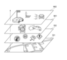
- FIGS. 1 and 2 are diagrams showing an example of the hierarchical structure of map data according to one embodiment of the present invention.
- the map data are classified into static information SI1, semi-static information SI2, semi-dynamic information MI1 and dynamic information MI2.
- the static information SI1 is three-dimensional high-precision fundamental map data (high-precision three-dimensional map data), including road surface information, lane information, three-dimensional structures, etc., and three-dimensional position coordinates indicating features. and linear vector data.
- the semi-static information SI2, the semi-dynamic information MI1, and the dynamic information MI2 are dynamic data that change from moment to moment, and are data superimposed on the static information based on the position information.
- the semi-static information SI2 includes traffic regulation information, road construction information, wide-area weather information, and the like.
- the semi-dynamic information MI1 includes accident information, traffic congestion information, narrow area weather information, and the like.
- the dynamic information MI2 includes ITS (Intelligent Transport System) information, including surrounding vehicles, pedestrians, signal information, and the like.
- the 3D map data in this embodiment may include 3D map data generated from satellite images.
- satellite images are corrected to generate high-precision map data, and this embodiment can also be applied to this three-dimensional map data.
- the three-dimensional map data is divided into predetermined three-dimensional spaces, and identification information is assigned to each three-dimensional space. This makes it possible to select the ID of each 3D space as appropriate when setting the routing of the aircraft or using it with other applications, eliminating the need to set the coordinate values and area of the desired area each time. . Therefore, according to the present embodiment, it is possible to set the flight route of the drone by dividing the space into sizes that are easy to manage, and to associate peripheral information such as weather information for each space.
- User-friendly 3D map data can be provided to the user.
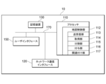
- FIG. 3 is a diagram showing an example of the configuration of the information processing device 10 according to one embodiment of the present invention.
- the information processing apparatus 10 includes one or more processors (CPUs: Central Processing Units) 110, one or more network communication interfaces 120, a storage device 130, a user interface 150, and 1 for interconnecting these components. It includes one or more communication buses 170 . Note that the user interface 150 may be connected via a network.
- the storage device 130 is, for example, high-speed random access memory such as DRAM, SRAM, or other random access solid-state memory devices.
- Storage 130 may also be non-volatile memory, such as one or more magnetic disk storage devices, optical disk storage devices, flash memory devices, or other non-volatile solid-state storage devices.
- the storage device 130 may be a non-temporary computer-readable recording medium.
- storage device 130 may be one or more storage devices installed remotely from the processor 110 .
- storage device 130 stores programs, modules, and data structures executed by processor 110, or a subset thereof.
- the storage device 130 stores data used by the information processing system 1 .
- the storage device 130 stores 3D map data and data relating to generation of this 3D map data.
- the storage device 130 stores 3D map data, feature data, and the like.
- an example of the three-dimensional map data includes static information SI1, semi-static information SI2, semi-dynamic information MI1, and dynamic information MI2, as described above with reference to FIG. information is associated with
- the static information SI1 includes high-precision 3D map data, and the high-precision 3D map data includes feature data.
- This feature data is basic information when an application uses this high-precision three-dimensional map data.
- the processor 110 that executes processing related to generation of 3D map data according to this embodiment will be described.
- the processor 110 configures the map control unit 212 , the transmission/reception unit 113 , the acquisition unit 114 , the division unit 115 , the addition unit 116 , and the association unit 117 by executing programs stored in the storage device 130 .
- the processor 110 controls the processing of each unit, which will be described later, and executes processing related to map data generation.
- the map control unit 112 uses various data to control the generation of 3D map data. For example, the map control unit 112 controls the generation of high-precision three-dimensional map data, divides the high-precision three-dimensional map data into predetermined three-dimensional spaces, and also controls the process of assigning identification information to each three-dimensional space. do.
- the transmission/reception unit 113 transmits/receives data to/from an external device via the network communication interface 120 .
- the transmitting/receiving unit 113 receives three-dimensional map data from an external device, or receives a satellite image including a predetermined position from an observation satellite.
- the transmission/reception unit 113 transmits the processed three-dimensional map data to an external device via the network communication interface 120 .
- the acquisition unit 114 acquires 3D map data.
- the acquisition unit 114 may acquire 3D map data stored in the storage device 130, or may acquire 3D map data received via the network communication interface 120 via the transmission/reception unit 113.
- the 3D map data may be 3D map data measured and generated by MMS (Mobile Mapping System), or may be 3D map data generated from satellite images. do not have.
- MMS Mobile Mapping System
- the division unit 115 divides the three-dimensional map data acquired by the acquisition unit 114 into predetermined three-dimensional spaces. For example, the dividing unit 115 divides the 3D map data into predetermined 3D spaces according to a predetermined standard to generate a plurality of 3D spaces.
- the shape of the three-dimensional space is not particularly limited, but the shape of the three-dimensional space may be specified according to the model of the three-dimensional map data. A rectangular parallelepiped shape is also included), and a cubic shape (including a substantially cubic shape) is more preferable.
- the three-dimensional space to be divided may be divided not only on the surface of the earth or on the sea, but also on the ground or in the sea.
- the assigning unit 116 assigns identification information to each divided three-dimensional space.
- the identification information may be information that can identify each three-dimensional space, and may be given according to a predetermined rule. From the viewpoint of data management, the assigning unit 116 preferably assigns identification information according to a rule that allows easy derivation of the surrounding three-dimensional space or the three-dimensional space within the same area.
- the identification information assigned to each three-dimensional space of the three-dimensional map data can be appropriately selected and extracted according to a predetermined purpose, thereby expanding the range of use. For example, in vehicle routing, this identification information can be selected and combined to allow the vehicle corridors to be set accordingly. In addition, it becomes possible to easily form a geofence or the like up to a predetermined height simply by selecting the identification information of the three-dimensional space.
- the dividing unit 115 divides the horizontal two-dimensional map data included in the three-dimensional map data into predetermined two-dimensional regions by dividing the two-dimensional region into predetermined heights. and generating a predetermined three-dimensional space.
- the dividing unit 115 uses UTM (Universal Transverse Mercator) grid-divided map data, divides each divided area into predetermined heights in the height direction, and generates each three-dimensional space. good. If the predetermined height is the same as the grid-divided longitude-latitude distance, a cubic three-dimensional space is generated, and if it is different from the grid-divided latitude-longitude distance, a rectangular parallelepiped three-dimensional space is generated. . This makes it possible to easily divide a three-dimensional space using existing map data.
- the dividing unit 115 divides the two-dimensional map data included in the three-dimensional map data into predetermined two-dimensional areas according to predetermined criteria, divides each two-dimensional area into predetermined heights, and divides each two-dimensional area into predetermined three-dimensional areas.
- a dimensional space may be generated. This allows the cartographer to freely determine the size of the three-dimensional space according to the purpose.
- the division unit 115 may also change the unit of the predetermined three-dimensional space according to the position within the three-dimensional map data. For example, the dividing unit 115 may appropriately change the size of the three-dimensional space based on the altitude or the position on the map in the horizontal direction. good too. This makes it possible to generate a flexible three-dimensional space according to the position of the three-dimensional map data.
- the dividing unit 115 may include changing at least the units in the height direction of the predetermined three-dimensional space based on the altitude. For example, the dividing unit 115 may increase the unit of division height as it goes higher in the sky. This is because it is considered that the higher the sky, the less the need for segmentation. Moreover, the dividing unit 115 may change not only the unit in the height direction of the three-dimensional space but also the size in the horizontal direction according to the altitude. For example, the dividing unit 115 may increase the horizontal size of the division as it goes higher in the sky.
- the dividing unit 115 may also include changing at least the horizontal unit of the predetermined three-dimensional space based on the feature data or area information included in the three-dimensional map data. For example, the division unit 115 may change at least the units in the horizontal direction of the three-dimensional space depending on whether the region to be divided is a mountainous area or an urban area. More specifically, if the region to be divided is a mountainous area, the division unit 115 may make the unit of the horizontal direction of the three-dimensional space larger than the unit of the urban area. Further, if the region to be divided is a mountainous area, the dividing unit 115 may make the unit in the height direction of the three-dimensional space larger than the unit of the urban area.
- the division unit 115 changes at least the horizontal unit of the predetermined three-dimensional space based on the type of feature data included in the three-dimensional map data (for example, highways, general roads, traffic lights, number of lanes). may include For example, the division unit 115 may increase the unit of the horizontal direction of the three-dimensional space for regions other than highways, highways with many lanes, and areas around traffic lights. In addition, the dividing unit 115 may increase the unit in the height direction of the three-dimensional space for regions other than expressways, arterial roads with many lanes, and areas around traffic lights.
- the horizontal size of the three-dimensional space it is possible to determine the horizontal size of the three-dimensional space according to the characteristics of the area based on the feature data or area information included in the three-dimensional map data. For example, by enlarging the unit in the horizontal direction of the three-dimensional space in the mountainous area, it is possible to reduce the load of the division processing and the processing of adding the identification information, and it is possible to perform the processing efficiently.
- the adding unit 116 may also add identification information based on coordinate values at predetermined positions in each three-dimensional space. For example, based on the coordinate values (longitude, latitude, altitude) of the central position in the three-dimensional space, the assigning unit 116 may combine the respective coordinate values to generate the identification information. Further, the granting unit 116 may grant identification information using a UTM zone number. For example, the identification number is a number of several digits indicating UTM zone number + latitude/longitude/altitude.
- the association unit 117 associates identification information corresponding to a predetermined position in the three-dimensional space with feature data in the three-dimensional space. For example, the associating unit 117 associates the center position in the three-dimensional space with feature data existing in the three-dimensional space.
- the feature data may already be included in the three-dimensional map data, or may be generated by extracting the data by image recognition or the like using an image in the three-dimensional space.
- the predetermined position in the three-dimensional space is not limited to the central position, and may be one of the vertices or a characteristic position in the three-dimensional space.
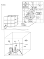
- FIG. 4 is a diagram showing an example of a three-dimensional space division process and an ID assignment process according to an embodiment of the present invention.
- the example shown in FIG. 4 shows an example in which a three-dimensional space area of Japan is divided into predetermined three-dimensional spaces.
- the dividing unit 115 divides the three-dimensional map data into the area of Japan (approximately 380,000 km 2 ) up to an altitude of 3000 m.
- Altitude 3000 is the maximum flight altitude of the helicopter without oxygen supply, although other altitude values may be used.
- the granting unit 116 grants identification information to each three-dimensional space.
- the granting unit 116 may grant two types of IDs, wide-range identification information ID1 and narrow-range identification information ID2.
- the wide-area identification information ID1 is, for example, an ID that identifies each three-dimensional space, and is also a management ID for managing each three-dimensional space.
- the narrow-area information ID2 included in each three-dimensional space the number of digits of the narrow-area information ID2 can be reduced, and the communication capacity when distributing the narrow-area information ID2 can be reduced. becomes possible.
- the narrow-area identification information ID2 is, for example, an ID that targets a predetermined area and is associated with the wide-area identification information ID1 and managed for each predetermined application. Also, narrow-range information ID2 is information for identifying an object, and its persistence may be guaranteed. Basically, one ID is assigned to one object, but if the same object has different acquisition criteria, it may be managed as a different ID.
- the predetermined district may be, for example, a densely inhabited district.
- the narrow-range identification information ID2 may be used for the purpose of managing necessary information, for example, in automated mobility operations.
- the predetermined application is AD (Autonomous Driving) / ADAS (advanced driver assistance system), PMV (Personal Mobility Vehicle), as an object of narrow-range identification information, roads, lanes, sidewalks, signs, road markings, Buildings and the like are used, and IDs (identification information) are assigned to them.
- the predetermined application is a flying object such as a drone, air routes, emergency evacuation areas, restricted flight areas, etc. are used as objects of narrow-area identification information, and IDs are assigned to these.
- the predetermined application is snow removal, lanes, sidewalks, manholes, bridge joints, etc. are used as narrow-area identification information objects, and identification information is assigned to these.
- the narrow-area identification information ID2 is an ID given to a predetermined position of a corridor used for routing of an aircraft, an ID of feature data used for automatic operation, and the like.
- the feature data shown in FIG. 4 are lanes.
- the association unit 117 associates the ID given to the lane and the ID of the corridor with the wide area ID.
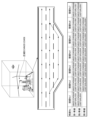
- FIG. 5 is a diagram showing an example of wide-area identification information and narrow-area identification information according to one embodiment of the present invention.
- the wide-area identification information for the three-dimensional space is "54N35123456". This is an example of information combining UTM zone "54”, north latitude "N35", and a 6-digit number (a number indicating longitude and altitude).
- the number of lanes in the roadway is 3, and the number of links connecting each lane is 7.
- the narrow-area identification information of the lane is first represented by the wide-area identification information "54N35123456", and is generated by linking the ID of the feature data to it. Note that the ID portion of the feature data linked to the wide-area identification information may be called narrow-area identification information.
- the 9-digit information of "ABCDEFGHI” includes common feature data information (described later with reference to FIGS. 6 and 7) and lane In the information "10001", the tenth digit "1" indicates lane 1, and the eleventh to fourteenth digits "0001" indicate the link number. This makes it possible to reduce the number of digits of the ID (narrow area identification information) of the feature data rather than assigning the ID to the feature data without distinguishing the three-dimensional space.
- the information given to the connection No in FIG. 5 indicates the lane link ID (narrow-range identification information of this lane link).
- FIG. 6 is a diagram showing an example of a feature code according to one embodiment of the present invention.
- a feature code is data relating to identification of a feature, and is, for example, data included in common information of feature data.
- Feature codes are associated with feature names.
- the feature code "01” indicates the feature name “lane link (lane link outside the intersection)"
- the feature code "02” indicates the feature name “lane link (lane link inside the intersection)”. )”.
- a lane link may also be written as a "lane centerline” and includes a plurality of constituent points.
- the type of feature can be identified by the first single digit of the feature code. For example, if the first digit of the feature code is "0", the feature is related to the lane link. If the first digit is "2", it is a feature painted on the road (division line, multi-division line, shoulder edge, tunnel boundary edge, etc.). If the first digit is "3", the features are intersections and road markings (regulatory markings, direction markings, other markings, etc.). If the first digit is "4", the feature is a road sign (guidance sign, warning sign, regulatory sign, instruction sign, other sign, unidentifiable sign, etc.). If the first digit is "5", the feature is a traffic signal (main body, auxiliary signal, arrow, etc.).
- FIG. 7 is a diagram showing an example of common information of feature data according to one embodiment of the present invention.
- the common information of feature data includes usage purpose information, feature code, material identification information, positioning state information, upward state information, imaging control information, and the like.
- Purpose of use information includes information specifying whether the AD/ADAS is to be used on private roads or on general roads.
- a private road refers to a road on which a vehicle moves in the lateral direction as it runs side by side at a branch, a merging section, or the like.
- the feature code includes any of the codes shown in FIG.
- the material identification information, positioning state information, and upward state information are information specified by the specifying unit 216 as described above. At least one piece of information specified by the specifying unit 216 is included in a predetermined field (LN (Line Number) field shown in FIG. 7) of the feature data shown in FIG. 7 by the generating unit 217 .
- FIG. 7 shows an example in which all of the material identification information, the positioning state information, and the upward state information are included in the feature data.
- the material identification information shown in FIG. 7 includes information for specifying any of measurement by MMS, drone measurement, fixed point measurement, measurement by air LiDAR, and measurement by satellite image/SAR image.
- the positioning state identification information includes information for specifying any of non-positioning, multipath environment, normal positioning (single positioning), normal positioning (sub-m class), and high-precision positioning (cm class).
- the upper state information includes information for specifying closed, partially open skies, or open skies.
- the imaging control information is information specified by the specifying unit 216 .
- the imaging control information may include an aperture value, an ISO value, a shutter speed, and the like.
- the identification information of the feature data should be linked to the common information shown in FIG. 7 and the information specific to the feature data should be added after the seventh digit.
- FIG. 8 is a diagram showing an example of associating identified lanes with buildings and facilities according to an embodiment of the present invention.
- the location information of Building 1 which is a predetermined building and facility, is the difference (X1, Y1, Z1).
- the building facility data of the first building as the feature data is generated by adding the difference (X1, Y1, Z1) to the lane link ID "XXXXX123456ABCDEFGHI1002" as relative position information to generate the ID "XXXXX123456ABCDEFGHI1002X1Y1Z1".
- the building facility data of the first building may include all kinds of information related to the first building, such as the type, shape and size of the building of the first building, as data associated with the ID.
- the building facility data is generated by newly generating the ID "XXXXX123456ABCDEFGHI1002X1Y1Z1" of the building facility data of the first building and linking the building facility information of the first building to the ID. It may be handled as extended data of the lane link ID "XXXXX123456ABCDEFGHI1002".
- the building facility data may be included in the feature data of the lane link ID by associating with the lane link ID "XXXX123456ABCDEFGHI1002" of the configuration point of the lane link.
- the relative position information is converted to (x1, y1, z1) by reducing the amount of information (number of digits) in consideration of a predetermined resolution, etc., within a range where the effect is small as data that is
- the data may be "XXXXXX123456ABCDEFGHI1002x1y1z1".
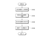
- FIG. 9 is a flow chart showing an example of processing related to ID assignment according to one embodiment of the present invention.
- step S102 the acquisition unit 114 of the information processing device 10 acquires 3D map data.
- the acquisition source of the 3D map data may be the storage device 130 or an external device on the network.
- step S104 the dividing unit 115 of the information processing device 10 divides the acquired three-dimensional map data into predetermined three-dimensional spaces according to predetermined criteria.
- Divider 115 preferably divides into cubes of a predetermined size.
- step S106 the assigning unit 116 of the information processing apparatus 10 assigns identification information to each divided three-dimensional space according to a predetermined rule.
- the predetermined rule is preferably a rule commonly used in the world, for example, a rule using position information.
- step S108 the association unit 117 of the information processing device 10 associates the identification information of the three-dimensional space with the feature data in this three-dimensional space. Note that the process of step S108 is not necessarily required.
- the identification information assigned to each three-dimensional space of the three-dimensional map data can be appropriately selected and extracted according to a predetermined purpose, thereby expanding the range of use. For example, in vehicle routing, this identification information can be selected and combined to allow the vehicle corridors to be set accordingly. In addition, it becomes possible to easily form a geofence or the like up to a predetermined height simply by selecting the identification information of the three-dimensional space.
- part of the processing executed by the information processing device 20 may be transferred to another information processing device, or a plurality of information processing devices may be appropriately integrated.
Abstract
This information processing method is executed by an information processing device including a processor, the processor acquiring 3D map data (S102), dividing the 3D map data into predetermined 3D spaces (S104), and assigning identification information to each divided 3D space (S106).
Description
本発明は、情報処理方法、プログラム、及び情報処理装置に関する。
The present invention relates to an information processing method, a program, and an information processing apparatus.
従来、3次元地図を表示する際に、2次元領域にIDが付与され、このIDを用いて表示エリアを抽出する方法が知られている(例えば特許文献1参照)。
Conventionally, when displaying a 3D map, a method is known in which an ID is assigned to a 2D area and the display area is extracted using this ID (see Patent Document 1, for example).
しかしながら、従来技術では、道路上を走る車両が移動する場合の画像表示に利用することが想定されており、その利用範囲が限定的であった。
However, with the conventional technology, it was assumed that it would be used for image display when vehicles running on the road were moving, and the scope of its use was limited.
ここで、近年、高精度な3次元の地図データが研究、開発されており、この3次元地図データの利用についての検討がなされている。例えば、ドローンなどの飛行体が操縦者の目視外の空域を航行することに対し、行き交うドローンが衝突しないようどのようにルーティングするかなど、3次元地図データの利用法について課題がある。
Here, in recent years, high-precision 3D map data has been researched and developed, and the use of this 3D map data is being considered. For example, there are issues regarding how to use 3D map data, such as how to route drones that come and go to prevent them from colliding when flying objects such as drones navigate in the airspace beyond the pilot's line of sight.
そこで、本発明は、3次元地図データの高さ方向に着目し、使い勝手の良い3次元地図データを提供することを目的とする。
Therefore, an object of the present invention is to provide user-friendly 3D map data by focusing on the height direction of 3D map data.
本発明の一態様に係る情報処理方法は、プロセッサを含む情報処理装置が実行する情報処理方法であって、前記プロセッサが、3次元地図データを取得すること、前記3次元地図データを所定の3次元空間に分割すること、分割された各3次元空間に識別情報を付与すること、を実行する。
An information processing method according to an aspect of the present invention is an information processing method executed by an information processing apparatus including a processor, wherein the processor acquires three-dimensional map data, and converts the three-dimensional map data into predetermined three It divides into dimensional spaces and assigns identification information to each divided three-dimensional space.
本発明によれば、3次元地図データの高さ方向に着目し、使い勝手の良い3次元地図データを提供することができる。
According to the present invention, it is possible to provide user-friendly 3D map data by focusing on the height direction of 3D map data.
[実施形態]
添付図面を参照して、本発明の好適な実施形態について説明する。なお、各図において、同一の符号を付したものは、同一又は同様の構成を有する。 [Embodiment]
Preferred embodiments of the present invention will be described with reference to the accompanying drawings. It should be noted that, in each figure, the same reference numerals have the same or similar configurations.
<地図データの概要>
図1及び図2を用いて本実施形態で用いられる地図データの概要について説明する。本実施形態で用いる地図データは、例えば、自動運転等に用いられる高精度な3次元地図データである。具体例としては、この地図データは、周辺車両の情報や交通情報といった、より動的な情報が付加されたリアルタイムに提供されるダイナミックマップと呼ばれる地図のデータである。本実施形態で用いられる地図データは、例えば4つの階層に分類される。 <Overview of map data>
An outline of the map data used in this embodiment will be described with reference to FIGS. 1 and 2. FIG. The map data used in this embodiment is, for example, highly accurate three-dimensional map data used for automatic driving or the like. As a specific example, this map data is map data called a dynamic map provided in real time to which more dynamic information such as information on surrounding vehicles and traffic information is added. The map data used in this embodiment are classified into, for example, four hierarchies.
図1及び2は、本発明の一実施形態に係る地図データの階層構造の一例を示す図である。図1及び2に示す例では、地図データは、静的情報SI1、準静的情報SI2、準動的情報MI1、動的情報MI2に分類される。
1 and 2 are diagrams showing an example of the hierarchical structure of map data according to one embodiment of the present invention. In the example shown in FIGS. 1 and 2, the map data are classified into static information SI1, semi-static information SI2, semi-dynamic information MI1 and dynamic information MI2.
静的情報SI1は、3次元の高精度な基盤的地図データ(高精度3次元地図データ)であって、路面情報、車線情報、3次元構造物等を含み、地物を示す3次元位置座標や線形ベクトルデータから構成される。準静的情報SI2、準動的情報MI1及び動的情報MI2は、時々刻々と変化する動的データであって、位置情報を基に静的情報に重畳されるデータである。
The static information SI1 is three-dimensional high-precision fundamental map data (high-precision three-dimensional map data), including road surface information, lane information, three-dimensional structures, etc., and three-dimensional position coordinates indicating features. and linear vector data. The semi-static information SI2, the semi-dynamic information MI1, and the dynamic information MI2 are dynamic data that change from moment to moment, and are data superimposed on the static information based on the position information.
準静的情報SI2は、交通規制情報、道路工事情報、広域気象情報などを含む。準動的情報MI1は、事故情報、渋滞情報、狭域気象情報などを含む。動的情報MI2は、ITS(Intelligent Transport System)情報を含み、周辺車両、歩行者、信号情報などを含む。
The semi-static information SI2 includes traffic regulation information, road construction information, wide-area weather information, and the like. The semi-dynamic information MI1 includes accident information, traffic congestion information, narrow area weather information, and the like. The dynamic information MI2 includes ITS (Intelligent Transport System) information, including surrounding vehicles, pedestrians, signal information, and the like.
また、本実施形態における3次元地図データとして、衛星画像から生成される3次元地図データを含んでもよい。例えば、衛星画像を補正して高精度な地図データが生成され、この3次元の地図データにも本実施形態は適用可能である。
Also, the 3D map data in this embodiment may include 3D map data generated from satellite images. For example, satellite images are corrected to generate high-precision map data, and this embodiment can also be applied to this three-dimensional map data.
以下、本実施形態における3次元地図データの空間分割について説明する。本実施形態では、高さ方向に着目し、3次元地図データを所定の3次元空間に分割し、各3次元空間に識別情報を付与する。これにより、飛行体のルーティング設定やその他のアプリケーションによる利用時に、各3次元空間のIDを適宜選択することが可能になり、その都度、所望の領域の座標値や領域を設定しなくても済む。したがって、本実施形態によれば、空間を管理しやすい大きさに分割することでドローンの飛行ルートを設定することを可能としたり、空間単位で気象情報などの周辺情報を紐付けたりすることができるなど、使い勝手の良い3次元地図データをユーザに対して提供することができる。
Spatial division of the 3D map data in this embodiment will be described below. In this embodiment, focusing on the height direction, the three-dimensional map data is divided into predetermined three-dimensional spaces, and identification information is assigned to each three-dimensional space. This makes it possible to select the ID of each 3D space as appropriate when setting the routing of the aircraft or using it with other applications, eliminating the need to set the coordinate values and area of the desired area each time. . Therefore, according to the present embodiment, it is possible to set the flight route of the drone by dividing the space into sizes that are easy to manage, and to associate peripheral information such as weather information for each space. User-friendly 3D map data can be provided to the user.
<情報処理装置の構成>
図3は、本発明の一実施形態に係る情報処理装置10の構成の一例を示す図である。情報処理装置10は、1つ又は複数のプロセッサ(CPU:Central Processing Unit)110、1つ又は複数のネットワーク通信インタフェース120、記憶装置130、ユーザインタフェース150及びこれらの構成要素を相互接続するための1つ又は複数の通信バス170を含む。なお、ユーザインタフェース150はネットワークを介して接続されてもよい。 <Configuration of information processing device>
FIG. 3 is a diagram showing an example of the configuration of theinformation processing device 10 according to one embodiment of the present invention. The information processing apparatus 10 includes one or more processors (CPUs: Central Processing Units) 110, one or more network communication interfaces 120, a storage device 130, a user interface 150, and 1 for interconnecting these components. It includes one or more communication buses 170 . Note that the user interface 150 may be connected via a network.
図3は、本発明の一実施形態に係る情報処理装置10の構成の一例を示す図である。情報処理装置10は、1つ又は複数のプロセッサ(CPU:Central Processing Unit)110、1つ又は複数のネットワーク通信インタフェース120、記憶装置130、ユーザインタフェース150及びこれらの構成要素を相互接続するための1つ又は複数の通信バス170を含む。なお、ユーザインタフェース150はネットワークを介して接続されてもよい。 <Configuration of information processing device>
FIG. 3 is a diagram showing an example of the configuration of the
記憶装置130は、例えば、DRAM、SRAM、他のランダムアクセス固体記憶装置などの高速ランダムアクセスメモリである。また、記憶装置130は、1つ又は複数の磁気ディスク記憶装置、光ディスク記憶装置、フラッシュメモリデバイス、又は他の不揮発性固体記憶装置などの不揮発性メモリでもよい。また、記憶装置130は、コンピュータ読み取り可能な非一時的な記録媒体でもよい。
The storage device 130 is, for example, high-speed random access memory such as DRAM, SRAM, or other random access solid-state memory devices. Storage 130 may also be non-volatile memory, such as one or more magnetic disk storage devices, optical disk storage devices, flash memory devices, or other non-volatile solid-state storage devices. Also, the storage device 130 may be a non-temporary computer-readable recording medium.
また、記憶装置130の他の例として、プロセッサ110から遠隔に設置される1つ又は複数の記憶装置でもよい。ある実施形態において、記憶装置130はプロセッサ110により実行されるプログラム、モジュール及びデータ構造、又はそれらのサブセットを格納する。
Another example of the storage device 130 may be one or more storage devices installed remotely from the processor 110 . In some embodiments, storage device 130 stores programs, modules, and data structures executed by processor 110, or a subset thereof.
記憶装置130は、情報処理システム1により用いられるデータを記憶する。例えば、記憶装置130は、3次元地図データ及びこの3次元地図データの生成に関するデータを記憶する。具体例としては、3次元地図データ、地物データなどが記憶装置130に記憶される。
The storage device 130 stores data used by the information processing system 1 . For example, the storage device 130 stores 3D map data and data relating to generation of this 3D map data. As a specific example, the storage device 130 stores 3D map data, feature data, and the like.
ここで、3次元地図データの一例は、図2を用いて上述したように、静的情報SI1と、準静的情報SI2と、準動的情報MI1と、動的情報MI2とを含み、それぞれの情報が関連付けられている。
Here, an example of the three-dimensional map data includes static information SI1, semi-static information SI2, semi-dynamic information MI1, and dynamic information MI2, as described above with reference to FIG. information is associated with
静的情報SI1は、高精度3次元地図データを含み、高精度3次元地図データは、地物データを含む。この地物データは、アプリケーションがこの高精度3次元地図データを利用する際に基本となる情報である。
The static information SI1 includes high-precision 3D map data, and the high-precision 3D map data includes feature data. This feature data is basic information when an application uses this high-precision three-dimensional map data.
本実施形態に係る3次元地図データの生成に関する処理を実行するプロセッサ110について説明する。プロセッサ110は、記憶装置130に記憶されるプログラムを実行することで、地図制御部212、送受信部113、取得部114、分割部115、付与部116、関連付け部117を構成する。
The processor 110 that executes processing related to generation of 3D map data according to this embodiment will be described. The processor 110 configures the map control unit 212 , the transmission/reception unit 113 , the acquisition unit 114 , the division unit 115 , the addition unit 116 , and the association unit 117 by executing programs stored in the storage device 130 .
プロセッサ110は、後述する各部の処理を制御し、地図データの生成に関する処理を実行する。
The processor 110 controls the processing of each unit, which will be described later, and executes processing related to map data generation.
地図制御部112は、各種データを用いて、3次元地図データの生成を制御する。例えば、地図制御部112は、高精度3次元地図データの生成を制御し、高精度3次元地図データを所定の3次元空間に分割し、各3次元空間に識別情報を付与する処理についても制御する。
The map control unit 112 uses various data to control the generation of 3D map data. For example, the map control unit 112 controls the generation of high-precision three-dimensional map data, divides the high-precision three-dimensional map data into predetermined three-dimensional spaces, and also controls the process of assigning identification information to each three-dimensional space. do.
送受信部113は、外部装置に対して、ネットワーク通信インタフェース120を介してデータの送受信を行う。例えば、送受信部113は、外部装置から3次元地図データを受信したり、観測衛星から、所定位置を含む衛星画像を受信したりする。また、送受信部113は、処理した3次元地図データを、ネットワーク通信インタフェース120を介して外部装置に送信する。
The transmission/reception unit 113 transmits/receives data to/from an external device via the network communication interface 120 . For example, the transmitting/receiving unit 113 receives three-dimensional map data from an external device, or receives a satellite image including a predetermined position from an observation satellite. Also, the transmission/reception unit 113 transmits the processed three-dimensional map data to an external device via the network communication interface 120 .
取得部114は、3次元地図データを取得する。例えば、取得部114は、記憶装置130に記憶される3次元地図データを取得してもよいし、送受信部113を経由してネットワーク通信インタフェース120を介して受信された3次元地図データを取得してもよい。また、3次元地図データは、MMS(Mobile Mapping System)により計測されて生成される3次元地図データでもよく、衛星画像から生成される3次元地図データでもよく、特にその生成過程が問われるものではない。
The acquisition unit 114 acquires 3D map data. For example, the acquisition unit 114 may acquire 3D map data stored in the storage device 130, or may acquire 3D map data received via the network communication interface 120 via the transmission/reception unit 113. may The 3D map data may be 3D map data measured and generated by MMS (Mobile Mapping System), or may be 3D map data generated from satellite images. do not have.
分割部115は、取得部114により取得される3次元地図データを所定の3次元空間に分割する。例えば、分割部115は、所定の基準に従って、3次元地図データを所定の3次元空間に分割し、複数の3次元空間を生成する。3次元空間の形状は特に限定されないが、3次元地図データのモデルに応じて3次元空間の形状が特定されてもよく、例えば、分割の容易性及び管理の効率性の観点から直方体形状(略直方体形状も含む)が好ましく、さらに立方体形状(略立方体形状も含む)がより好ましい。また、分割対象となる3次元空間は、地表や海上だけではなく、地下や海中なども分割されてもよい。
The division unit 115 divides the three-dimensional map data acquired by the acquisition unit 114 into predetermined three-dimensional spaces. For example, the dividing unit 115 divides the 3D map data into predetermined 3D spaces according to a predetermined standard to generate a plurality of 3D spaces. The shape of the three-dimensional space is not particularly limited, but the shape of the three-dimensional space may be specified according to the model of the three-dimensional map data. A rectangular parallelepiped shape is also included), and a cubic shape (including a substantially cubic shape) is more preferable. Moreover, the three-dimensional space to be divided may be divided not only on the surface of the earth or on the sea, but also on the ground or in the sea.
付与部116は、分割された各3次元空間に識別情報を付与する。識別情報は、各3次元空間を識別できる情報であればよく、所定のルールに従って付与されればよい。また、付与部116は、データ管理の観点から、周囲の3次元空間、又は同じ地域内の3次元空間が容易に導き出せるようなルールにより識別情報を付与するとよい。
The assigning unit 116 assigns identification information to each divided three-dimensional space. The identification information may be information that can identify each three-dimensional space, and may be given according to a predetermined rule. From the viewpoint of data management, the assigning unit 116 preferably assigns identification information according to a rule that allows easy derivation of the surrounding three-dimensional space or the three-dimensional space within the same area.
以上の処理によれば、3次元地図データのうち、車両等が走行する地上の水平面だけではなく、高さ方向にも着目し、使い勝手の良い3次元地図データを提供することが可能になる。すわなち、3次元地図データの各3次元空間に付与された識別情報は、所定の目的に応じて適宜選択、抽出されるなどの利用の幅を広げることが可能になる。例えば、飛行体のルーティングにおいて、この識別情報を選択して組み合わせることで、飛行体のコリドーを適宜設定することが可能になる。また、3次元空間の識別情報を選択するだけで、所定の高さまでのジオフェンスなどを容易に形成することが可能になる。
According to the above processing, it is possible to provide user-friendly 3D map data by focusing not only on the horizontal plane of the ground where the vehicle or the like travels, but also on the height direction. That is, the identification information assigned to each three-dimensional space of the three-dimensional map data can be appropriately selected and extracted according to a predetermined purpose, thereby expanding the range of use. For example, in vehicle routing, this identification information can be selected and combined to allow the vehicle corridors to be set accordingly. In addition, it becomes possible to easily form a geofence or the like up to a predetermined height simply by selecting the identification information of the three-dimensional space.
また、分割部115は、3次元地図データに含まれる水平方向の2次元地図データに対し、水平方向に分割された所定の2次元領域を用いて、2次元領域を所定の高さごとに分割し、所定の3次元空間を生成することを含んでもよい。例えば、分割部115は、UTM(Universal Transverse Mercator)グリッド分割された地図データを利用し、各分割領域を高さ方向に所定の高さに分割していき、各3次元空間を生成してもよい。所定の高さが、グリッド分割された経度緯度の距離と同じであれば、立方体の3次元空間が生成され、グリッド分割された緯度経度の距離と異なれば、直方体の3次元空間が生成される。これにより、既存の地図データを利用して、容易に3次元空間を分割することが可能になる。
Further, the dividing unit 115 divides the horizontal two-dimensional map data included in the three-dimensional map data into predetermined two-dimensional regions by dividing the two-dimensional region into predetermined heights. and generating a predetermined three-dimensional space. For example, the dividing unit 115 uses UTM (Universal Transverse Mercator) grid-divided map data, divides each divided area into predetermined heights in the height direction, and generates each three-dimensional space. good. If the predetermined height is the same as the grid-divided longitude-latitude distance, a cubic three-dimensional space is generated, and if it is different from the grid-divided latitude-longitude distance, a rectangular parallelepiped three-dimensional space is generated. . This makes it possible to easily divide a three-dimensional space using existing map data.
また、分割部115は、所定の基準に従って、3次元地図データに含まれる2次元地図データを所定の2次元領域に分割し、各2次元領域を所定の高さごとに分割し、所定の3次元空間を生成してもよい。これにより、地図作成者が、目的に応じて、3次元空間のサイズを自由に決定することが可能になる。
Further, the dividing unit 115 divides the two-dimensional map data included in the three-dimensional map data into predetermined two-dimensional areas according to predetermined criteria, divides each two-dimensional area into predetermined heights, and divides each two-dimensional area into predetermined three-dimensional areas. A dimensional space may be generated. This allows the cartographer to freely determine the size of the three-dimensional space according to the purpose.
また、分割部115は、3次元地図データ内の位置に応じて、所定の3次元空間の単位を変更することを含んでもよい。例えば、分割部115は、高度、又は水平方向の地図上の位置に基づいて、3次元空間のサイズを適宜変更してもよく、目的に応じて、分割を細分化したり、集約化したりしてもよい。これにより、3次元地図データの位置に応じた柔軟な3次元空間を生成することが可能になる。なお、高度については、標高、ジオイド高、楕円体高のいずれか一つを基準にすればよい。また、3次元空間の大きさをできるだけ均一にするなら、ジオイド高を用いて高度を規定すればよい。また、後述する空間領域に付与されるIDをキーにして、標高=楕円体高-ジオイド高の関係を用いて、ジオイド高から楕円体高又は標高が導かれてもよい。
The division unit 115 may also change the unit of the predetermined three-dimensional space according to the position within the three-dimensional map data. For example, the dividing unit 115 may appropriately change the size of the three-dimensional space based on the altitude or the position on the map in the horizontal direction. good too. This makes it possible to generate a flexible three-dimensional space according to the position of the three-dimensional map data. The altitude may be based on any one of altitude, geoid height, and ellipsoid height. Also, if the size of the three-dimensional space is to be made uniform as much as possible, then the geoid height should be used to define the altitude. Also, the ellipsoidal height or the altitude may be derived from the geoidal height using the relationship of altitude=ellipsoidal height−geoidal height using an ID assigned to a spatial region, which will be described later, as a key.
また、分割部115は、高度に基づき、所定の3次元空間の高さ方向の単位を少なくとも変更することを含んでもよい。例えば、分割部115は、上空に行けば行くほど、分割の高さの単位をより大きくしてもよい。これは、上空に行くほど細分化の必要性が小さいと考えられるからである。また、分割部115は、高度に応じて3次元空間の高さ方向の単位を変えるだけではなく、水平方向のサイズを変更してもよい。例えば、分割部115は、上空に行けば行くほど、分割の水平方向のサイズをより大きくしてもよい。
Further, the dividing unit 115 may include changing at least the units in the height direction of the predetermined three-dimensional space based on the altitude. For example, the dividing unit 115 may increase the unit of division height as it goes higher in the sky. This is because it is considered that the higher the sky, the less the need for segmentation. Moreover, the dividing unit 115 may change not only the unit in the height direction of the three-dimensional space but also the size in the horizontal direction according to the altitude. For example, the dividing unit 115 may increase the horizontal size of the division as it goes higher in the sky.
これにより、高度に応じて、3次元空間の高さ方向の単位を少なくとも変更することにより、高さ方向における分割の集約化、細分化の必要性に応じることが可能になる。例えば、上空に行けば行くほど高さ方向の単位を大きくすることで、分割処理や識別情報の付与処理の負担を減らすことができ、効率よく処理を行うことが可能になる。
As a result, by changing at least the units in the height direction of the three-dimensional space according to the altitude, it is possible to respond to the need for consolidation and subdivision of divisions in the height direction. For example, by increasing the unit in the height direction as you go higher in the sky, it is possible to reduce the burden of the dividing process and the process of adding identification information, and it is possible to perform the process efficiently.
また、分割部115は、3次元地図データに含まれる地物データ又は領域情報に基づき、所定の3次元空間の水平方向の単位を少なくとも変更することを含んでもよい。例えば、分割部115は、分割対象領域が山間部か市街地かにより、3次元空間の水平方向の単位を少なくとも変更してもよい。より具体的には、分割部115は、分割対象領域が山間部であれば、3次元空間の水平方向の単位を市街地の単位よりも大きくしてもよい。また、分割部115は、分割対象領域が山間部であれば、3次元空間の高さ方向の単位を、市街地の単位よりも大きくしてもよい。
The dividing unit 115 may also include changing at least the horizontal unit of the predetermined three-dimensional space based on the feature data or area information included in the three-dimensional map data. For example, the division unit 115 may change at least the units in the horizontal direction of the three-dimensional space depending on whether the region to be divided is a mountainous area or an urban area. More specifically, if the region to be divided is a mountainous area, the division unit 115 may make the unit of the horizontal direction of the three-dimensional space larger than the unit of the urban area. Further, if the region to be divided is a mountainous area, the dividing unit 115 may make the unit in the height direction of the three-dimensional space larger than the unit of the urban area.
また、分割部115は、3次元地図データに含まれる地物データの種類(例えば、高速道路、一般道路、信号機、車線数)に基づき、所定の3次元空間の水平方向の単位を少なくとも変更することを含んでもよい。例えば、分割部115は、高速道路、車線数が多い幹線道路、信号機周辺以外の領域について、3次元空間の水平方向の単位をより大きくしてもよい。また、分割部115は、高速道路、車線数が多い幹線道路、信号機周辺以外の領域について、3次元空間の高さ方向の単位をより大きくしてもよい。
Further, the division unit 115 changes at least the horizontal unit of the predetermined three-dimensional space based on the type of feature data included in the three-dimensional map data (for example, highways, general roads, traffic lights, number of lanes). may include For example, the division unit 115 may increase the unit of the horizontal direction of the three-dimensional space for regions other than highways, highways with many lanes, and areas around traffic lights. In addition, the dividing unit 115 may increase the unit in the height direction of the three-dimensional space for regions other than expressways, arterial roads with many lanes, and areas around traffic lights.
これにより、3次元地図データに含まれる地物データ又は領域情報に基づくことにより、そのエリアの特性に応じて3次元空間の水平方向のサイズを決定することが可能になる。例えば、山間部は3次元空間の水平方向の単位を大きくすることで、分割処理や識別情報の付与処理の負担を減らすことができ、効率よく処理を行うことが可能になる。
As a result, it is possible to determine the horizontal size of the three-dimensional space according to the characteristics of the area based on the feature data or area information included in the three-dimensional map data. For example, by enlarging the unit in the horizontal direction of the three-dimensional space in the mountainous area, it is possible to reduce the load of the division processing and the processing of adding the identification information, and it is possible to perform the processing efficiently.
また、付与部116は、各3次元空間内の所定位置における座標値に基づく識別情報を付与ることを含んでもよい。例えば、付与部116は、3次元空間内の中心位置の座標値(経度、緯度、高度)に基づき、それぞれの座標値を組み合せて識別情報を生成してもよい。また、付与部116は、UTMゾーンの番号を利用して識別情報を付与してもよい。例えば、識別番号は、UTMゾーン番号+緯度経度高度を示す数桁の番号などである。
The adding unit 116 may also add identification information based on coordinate values at predetermined positions in each three-dimensional space. For example, based on the coordinate values (longitude, latitude, altitude) of the central position in the three-dimensional space, the assigning unit 116 may combine the respective coordinate values to generate the identification information. Further, the granting unit 116 may grant identification information using a UTM zone number. For example, the identification number is a number of several digits indicating UTM zone number + latitude/longitude/altitude.
これにより、3次元空間の識別番号を検索する際に、地域性を用いて3次元空間を絞り込むことが可能になる。
This makes it possible to narrow down the 3D space using regional characteristics when searching for the identification number of the 3D space.
関連付け部117は、3次元空間内の所定位置に対応する識別情報と、この3次元空間内の地物データとを関連付ける。例えば、関連付け部117は、3次元空間内の中心位置に、この3次元空間内に存在する地物データを関連づける。地物データは、3次元地図データに既に含まれていてもよいし、3次元空間内の画像を用いて画像認識等で抽出して生成されてもよい。なお、3次元空間内の所定位置は、中心位置に限らず、各頂点のうちの一つの頂点位置でもよいし、3次元空間内の特徴的な位置でもよい。
The association unit 117 associates identification information corresponding to a predetermined position in the three-dimensional space with feature data in the three-dimensional space. For example, the associating unit 117 associates the center position in the three-dimensional space with feature data existing in the three-dimensional space. The feature data may already be included in the three-dimensional map data, or may be generated by extracting the data by image recognition or the like using an image in the three-dimensional space. Note that the predetermined position in the three-dimensional space is not limited to the central position, and may be one of the vertices or a characteristic position in the three-dimensional space.
これにより、3次元地図データの各3次元空間の識別情報から、その3次元空間内の地物データを抽出することができるようになり、地物データを用いての自動運転技術や、地物管理等に利用することも可能になる。
As a result, it becomes possible to extract the feature data in the three-dimensional space from the identification information of each three-dimensional space of the three-dimensional map data. It can also be used for management and the like.
<具体例>
次に、3次元空間の分割、識別情報の付与について具体例を用いて説明する。図4は、本発明の一実施形態に係る3次元空間の分割処理及びIDの付与処理の一例を示す図である。図4に示す例では、日本国土の3次元空間の領域を、所定の3次元空間に分割する例を示す。例えば、分割部115は、3次元地図データのうち、日本の領域(約38万km2)であり、高度3000mまでを分割対象とする。高度3000は、酸素供給なしでのヘリコプターの最高飛行高度であるが、その他の高度の値を用いてもよい。 <Specific example>
Next, the division of the three-dimensional space and the assignment of identification information will be described using a specific example. FIG. 4 is a diagram showing an example of a three-dimensional space division process and an ID assignment process according to an embodiment of the present invention. The example shown in FIG. 4 shows an example in which a three-dimensional space area of Japan is divided into predetermined three-dimensional spaces. For example, the dividingunit 115 divides the three-dimensional map data into the area of Japan (approximately 380,000 km 2 ) up to an altitude of 3000 m. Altitude 3000 is the maximum flight altitude of the helicopter without oxygen supply, although other altitude values may be used.
次に、3次元空間の分割、識別情報の付与について具体例を用いて説明する。図4は、本発明の一実施形態に係る3次元空間の分割処理及びIDの付与処理の一例を示す図である。図4に示す例では、日本国土の3次元空間の領域を、所定の3次元空間に分割する例を示す。例えば、分割部115は、3次元地図データのうち、日本の領域(約38万km2)であり、高度3000mまでを分割対象とする。高度3000は、酸素供給なしでのヘリコプターの最高飛行高度であるが、その他の高度の値を用いてもよい。 <Specific example>
Next, the division of the three-dimensional space and the assignment of identification information will be described using a specific example. FIG. 4 is a diagram showing an example of a three-dimensional space division process and an ID assignment process according to an embodiment of the present invention. The example shown in FIG. 4 shows an example in which a three-dimensional space area of Japan is divided into predetermined three-dimensional spaces. For example, the dividing
分割部115は、分割対象領域を、各辺を1kmとする立方体に分割する。このとき、38万(km2)×3(km)=114万(個)の3次元空間が生成される。なお、各辺の単位は、1kmでなくてもよく、5km、500m、100mなどでもよい。また、3次元空間の形状は、立方体ではなく、直方体などの3次元空間でもよい。
The dividing unit 115 divides the region to be divided into cubes each side of which is 1 km. At this time, a three-dimensional space of 380,000 (km 2 )×3 (km)=1,140,000 (pieces) is generated. Note that the unit of each side need not be 1 km, and may be 5 km, 500 m, 100 m, or the like. Also, the shape of the three-dimensional space may be a three-dimensional space such as a rectangular parallelepiped instead of a cube.
付与部116は、各3次元空間に識別情報を付与する。例えば、付与部116は、広域識別情報ID1と狭域識別情報ID2との2種類のIDを付与してもよい。広域識識別情報ID1は、例えば、各3次元空間を識別するIDであり、各3次元空間を管理するための管理IDでもある。また、3次元空間毎に、その空間内に含む狭域情報ID2が管理されることにより、狭域情報ID2の桁数を削減し、狭域情報ID2を配信する際の通信容量を低減することが可能になる。
The granting unit 116 grants identification information to each three-dimensional space. For example, the granting unit 116 may grant two types of IDs, wide-range identification information ID1 and narrow-range identification information ID2. The wide-area identification information ID1 is, for example, an ID that identifies each three-dimensional space, and is also a management ID for managing each three-dimensional space. In addition, by managing the narrow-area information ID2 included in each three-dimensional space, the number of digits of the narrow-area information ID2 can be reduced, and the communication capacity when distributing the narrow-area information ID2 can be reduced. becomes possible.
狭域識別情報ID2は、例えば、所定の地区を対象とし、広域識別情報ID1に対応づけた、所定のアプリケーション別に管理するIDである。また、狭域情報ID2は、オブジェクトを識別する情報であり、永続性が保証されてもよい。1つのオブジェクトに1つのIDが付与されることが基本であるが、オブジェクトが同じでも取得基準が異なる場合には、別IDとして管理されてもよい。なお、所定の地区は、例えば、人口集中地区(Densely Inhabited District)を対象としてもよい。
The narrow-area identification information ID2 is, for example, an ID that targets a predetermined area and is associated with the wide-area identification information ID1 and managed for each predetermined application. Also, narrow-range information ID2 is information for identifying an object, and its persistence may be guaranteed. Basically, one ID is assigned to one object, but if the same object has different acquisition criteria, it may be managed as a different ID. The predetermined district may be, for example, a densely inhabited district.
また、狭域識別情報ID2は、例えば自動化されたMobilityの運行において、必要情報を管理する目的で利用されてもよい。例えば、所定のアプリケーションが、AD(Autonomous Driving)/ADAS(advanced driver assistance system)、PMV(Personal Mobility Vehicle)であれば、狭域識別情報のオブジェクトとして、車道・車線・歩道・標識・道路標示・建物等が使用され、これらにID(識別情報)が振られる。また、所定のアプリケーションがドローンなどの飛行体の場合、狭域識別情報のオブジェクトとして、空路・緊急退避区域・飛行制限区域等が使用され、これらにIDが振られる。所定のアプリケーションが、除雪であれば、狭域識別情報のオブジェクトとして、車線・歩道・マンホール・橋梁ジョイント等が使用され、これらに識別情報が振られる。
Also, the narrow-range identification information ID2 may be used for the purpose of managing necessary information, for example, in automated mobility operations. For example, if the predetermined application is AD (Autonomous Driving) / ADAS (advanced driver assistance system), PMV (Personal Mobility Vehicle), as an object of narrow-range identification information, roads, lanes, sidewalks, signs, road markings, Buildings and the like are used, and IDs (identification information) are assigned to them. Also, when the predetermined application is a flying object such as a drone, air routes, emergency evacuation areas, restricted flight areas, etc. are used as objects of narrow-area identification information, and IDs are assigned to these. If the predetermined application is snow removal, lanes, sidewalks, manholes, bridge joints, etc. are used as narrow-area identification information objects, and identification information is assigned to these.
具体例としては、狭域識別情報ID2は、飛行体のルーティング等に用いられるコリドーの所定位置に付与されるIDや、自動運転に利用される地物データのIDなどである。図4に示す地物データは車線である。関連付け部117は、この車線に付与されるIDや、コリドーのIDを広域IDに関連付ける。
As a specific example, the narrow-area identification information ID2 is an ID given to a predetermined position of a corridor used for routing of an aircraft, an ID of feature data used for automatic operation, and the like. The feature data shown in FIG. 4 are lanes. The association unit 117 associates the ID given to the lane and the ID of the corridor with the wide area ID.
次に、付与される広域識別情報と、狭域識別情報との例について説明する。図5は、本発明の一実施形態に係る広域識別情報及び狭域識別情報の一例を示す図である。図5に示す例では、3次元空間の広域識別情報は、「54N35123456」とする。これは、UTMゾーンの「54」と、北緯「N35」と、6桁番号(経度及び高度を示す番号)とを組み合わせた情報の例である。
Next, examples of given wide-range identification information and narrow-range identification information will be described. FIG. 5 is a diagram showing an example of wide-area identification information and narrow-area identification information according to one embodiment of the present invention. In the example shown in FIG. 5, the wide-area identification information for the three-dimensional space is "54N35123456". This is an example of information combining UTM zone "54", north latitude "N35", and a 6-digit number (a number indicating longitude and altitude).
図5に示す例では、車道内の車線数は3、各車線を接続するリンク数は7である。車線の狭域識別情報は、まずは広域識別情報「54N35123456」で表し、それに地物データのIDを連結させて生成される。なお、広域識別情報に連結される地物データのID部分を狭域識別情報と呼んでもよい。
In the example shown in FIG. 5, the number of lanes in the roadway is 3, and the number of links connecting each lane is 7. The narrow-area identification information of the lane is first represented by the wide-area identification information "54N35123456", and is generated by linking the ID of the feature data to it. Note that the ID portion of the feature data linked to the wide-area identification information may be called narrow-area identification information.
図5に示す例では、車線の地物データのIDが「ABCDEFGHI1001」の場合、「ABCDEFGHI」の9桁の情報は、地物データの共通情報(図6及び7を用いて後述)と、車線の地物データを表すデータが含まれ、「10001」の情報は、10桁目の「1」が車線1を示し、11~14桁目の「0001」がリンク番号を示す。これにより、3次元空間を区別することなく、地物データにIDを付与するよりも、地物データのID(狭域識別情報)の桁数を減らすことが可能になる。なお、図5における接続Noに付与される情報は、車線リンクID(この車線リンクの狭域識別情報)を示す。
In the example shown in FIG. 5, when the lane feature data ID is "ABCDEFGHI1001", the 9-digit information of "ABCDEFGHI" includes common feature data information (described later with reference to FIGS. 6 and 7) and lane In the information "10001", the tenth digit "1" indicates lane 1, and the eleventh to fourteenth digits "0001" indicate the link number. This makes it possible to reduce the number of digits of the ID (narrow area identification information) of the feature data rather than assigning the ID to the feature data without distinguishing the three-dimensional space. The information given to the connection No in FIG. 5 indicates the lane link ID (narrow-range identification information of this lane link).
次に、地物データを識別する地物コードと、この地物コードを含む地物データの共通情報について説明する。上述した例では、「ABCDEFGHI」のうちの最初の6桁が各地物データにおいて共通で使用されるIDとする。
Next, we will explain the feature code that identifies the feature data and the common information of the feature data that includes this feature code. In the above example, it is assumed that the first six digits of "ABCDEFGHI" are IDs commonly used in each feature data.
図6は、本発明の一実施形態に係る地物コードの一例を示す図である。地物コードは、地物の識別に関するデータであり、例えば、地物データの共通情報に含められるデータである。地物コードは、地物名に関連付けられる。
FIG. 6 is a diagram showing an example of a feature code according to one embodiment of the present invention. A feature code is data relating to identification of a feature, and is, for example, data included in common information of feature data. Feature codes are associated with feature names.
図6に示す例において、地物コード「01」は、地物名「車線リンク(交差点外車線リンク)」を示し、地物コード「02」は、地物名「車線リンク(交差点内車線リンク)」を示す。なお、車線リンクは、「車線中心線」と表記してもよく、複数の構成点を含む。
In the example shown in FIG. 6, the feature code "01" indicates the feature name "lane link (lane link outside the intersection)", and the feature code "02" indicates the feature name "lane link (lane link inside the intersection)". )”. Note that a lane link may also be written as a "lane centerline" and includes a plurality of constituent points.
また、地物コードの最初の一桁の数字により、地物の種類は判別可能である。例えば、地物コードの最初の一桁が「0」であれば、地物は車線リンクに関する地物である。最初の一桁が「2」であれば、路上にペイント等された地物(区画線、多重区画線、路肩縁、トンネル境界縁等)である。最初の一桁が「3」であれば、地物は交差点及び道路標示(規制標示、指示標示、その他標示等)である。最初の一桁が「4」であれば、地物は道路標識(案内標識、警戒標識、規制標識、指示標識、その他標識、識別不能標識等)である。最初の一桁が「5」であれば、地物は車両信号機(本体、補助信号、矢印等)である。
Also, the type of feature can be identified by the first single digit of the feature code. For example, if the first digit of the feature code is "0", the feature is related to the lane link. If the first digit is "2", it is a feature painted on the road (division line, multi-division line, shoulder edge, tunnel boundary edge, etc.). If the first digit is "3", the features are intersections and road markings (regulatory markings, direction markings, other markings, etc.). If the first digit is "4", the feature is a road sign (guidance sign, warning sign, regulatory sign, instruction sign, other sign, unidentifiable sign, etc.). If the first digit is "5", the feature is a traffic signal (main body, auxiliary signal, arrow, etc.).
図7は、本発明の一実施形態に係る地物データの共通情報の一例を示す図である。図7に示す例では、地物データの共通情報は、使用目的情報、地物コード、素材識別情報、測位状態情報、上方状態情報、撮像制御情報等を含む。
FIG. 7 is a diagram showing an example of common information of feature data according to one embodiment of the present invention. In the example shown in FIG. 7, the common information of feature data includes usage purpose information, feature code, material identification information, positioning state information, upward state information, imaging control information, and the like.
使用目的情報は、AD/ADASを自専道で使用するか、一般道で使用するかを特定する情報を含む。自専道とは、分岐、合流区画などで並走状態として車両の横方向への移動が行われる道路等を示す。地物コードは、図6に示すコードのいずれかを含む。
Purpose of use information includes information specifying whether the AD/ADAS is to be used on private roads or on general roads. A private road refers to a road on which a vehicle moves in the lateral direction as it runs side by side at a branch, a merging section, or the like. The feature code includes any of the codes shown in FIG.
素材識別情報、測位状態情報、及び上方状態情報は、上述したように、特定部216により特定される情報である。特定部216により特定された各情報の少なくとも1つが、生成部217により、図7に示す地物データの所定のフィールド(図7に示すLN(Line Number)のフィールド)に含められる。図7では、素材識別情報、測位状態情報、及び上方状態情報の全てが地物データに含められる例を示す。
The material identification information, positioning state information, and upward state information are information specified by the specifying unit 216 as described above. At least one piece of information specified by the specifying unit 216 is included in a predetermined field (LN (Line Number) field shown in FIG. 7) of the feature data shown in FIG. 7 by the generating unit 217 . FIG. 7 shows an example in which all of the material identification information, the positioning state information, and the upward state information are included in the feature data.
図7に示す素材識別情報は、MMSによる計測、ドローン計測、定点計測、航空LiDARによる計測、衛星画像/SARの画像により計測のいずれかを特定するための情報を含む。測位状態識別情報は、未測位、マルチパス環境下、通常測位(単独測位)、通常測位(サブm級)、高精度測位(cm級)のいずれかを特定するための情報を含む。上方状態情報は、クローズド、一部オープンスカイ、オープンスカイのいずれかを特定するための情報を含む。
The material identification information shown in FIG. 7 includes information for specifying any of measurement by MMS, drone measurement, fixed point measurement, measurement by air LiDAR, and measurement by satellite image/SAR image. The positioning state identification information includes information for specifying any of non-positioning, multipath environment, normal positioning (single positioning), normal positioning (sub-m class), and high-precision positioning (cm class). The upper state information includes information for specifying closed, partially open skies, or open skies.
撮像制御情報は、特定部216により特定される情報である。図7に示す例では、撮像された画像の画素値のヒストグラムを用いて、白飛び、黒つぶれなどが特定される。また、撮像制御情報として、絞り値、ISO値、シャッタースピードなどを含んでもよい。地物データに撮像制御情報が含まれることで、車載カメラは撮像制御情報に基づき、適切なパラメータを用いて地物を撮像し、適切に地物を検出することが可能になる。
The imaging control information is information specified by the specifying unit 216 . In the example shown in FIG. 7, blown-out highlights, blocked-up shadows, and the like are specified using a histogram of pixel values of a captured image. Also, the imaging control information may include an aperture value, an ISO value, a shutter speed, and the like. By including the imaging control information in the feature data, the in-vehicle camera can capture an image of the feature using appropriate parameters based on the imaging control information and detect the feature appropriately.
地物データの識別情報は、図7に示す共通情報に連結させて7桁目以降で地物データ固有の情報を付加するとよい。
The identification information of the feature data should be linked to the common information shown in FIG. 7 and the information specific to the feature data should be added after the seventh digit.
次に、車道沿いにある建物や施設の地物データを車線の地物データに関連づける例について説明する。図8は、本発明の一実施形態に係る特定された車線と建物及び施設とを関連付ける一例を示す図である。図8に示すように、所定の建物及び施設である第1ビルの位置情報は、第1ビルの出入口と、車線リンクID「XXXXX123456ABCDEFGHI1002」で表される車線リンクの構成点との差分(X1,Y1,Z1)で表現される。そして、地物データとしての第1ビルの建物施設データは、車線リンクID「XXXXX123456ABCDEFGHI1002」に当該差分(X1,Y1,Z1)を相対位置情報として付加するようにして、ID「XXXXX123456ABCDEFGHI1002X1Y1Z1」が生成される。さらに、第1ビルの建物施設データには、当該IDに紐付くデータとして、第1ビルの建物の種類、形状及び大きさ等、第1ビルに関するあらゆる情報が含まれても構わない。
Next, we will explain an example of associating the feature data of buildings and facilities along the roadway with the feature data of the lane. FIG. 8 is a diagram showing an example of associating identified lanes with buildings and facilities according to an embodiment of the present invention. As shown in FIG. 8, the location information of Building 1, which is a predetermined building and facility, is the difference (X1, Y1, Z1). Then, the building facility data of the first building as the feature data is generated by adding the difference (X1, Y1, Z1) to the lane link ID "XXXXX123456ABCDEFGHI1002" as relative position information to generate the ID "XXXXX123456ABCDEFGHI1002X1Y1Z1". be. Further, the building facility data of the first building may include all kinds of information related to the first building, such as the type, shape and size of the building of the first building, as data associated with the ID.
また、ここでは、新たに第1ビルの建物施設データのID「XXXXX123456ABCDEFGHI1002X1Y1Z1」を生成し、当該第1ビルの建物施設情報を当該IDに紐づけるようにして建物施設データを生成したが、これらを車線リンクID「XXXXX123456ABCDEFGHI1002」の拡張データとして取り扱うようにしても構わない。例えば、車線リンクの構成点の車線リンクID「XXXXX123456ABCDEFGHI1002」に紐付けて、当該車線リンクIDの地物データに建物施設データを含めるようにしても構わない。当該車線リンクの周辺に位置する建物及び施設等が、当該車線リンクIDに直接紐付いていることにより、その関連性を把握することができ、また、データ整理の観点においても利便性が良い場合がある。
Also, here, the building facility data is generated by newly generating the ID "XXXXX123456ABCDEFGHI1002X1Y1Z1" of the building facility data of the first building and linking the building facility information of the first building to the ID. It may be handled as extended data of the lane link ID "XXXXXX123456ABCDEFGHI1002". For example, the building facility data may be included in the feature data of the lane link ID by associating with the lane link ID "XXXX123456ABCDEFGHI1002" of the configuration point of the lane link. By directly linking the buildings and facilities located around the lane link with the lane link ID, it is possible to grasp the relationship between them, and it is also convenient from the viewpoint of data organization. be.
なお、相対位置(X1,Y1,Z1)に関する情報量が大きく、メモリを圧迫し、算出処理やデータ通信等の遅延が発生するおそれがある場合には、運転支援システム及び自動運転システムに利用されるデータとして影響が小さい範囲で、例えば、所定の分解能を考慮して情報量(桁数)を少なくする等によって相対位置情報を(x1,y1,z1)と変換し、第1ビルの建物施設データを「XXXXX123456ABCDEFGHI1002x1y1z1」としても構わない。
In addition, when the amount of information related to the relative position (X1, Y1, Z1) is large and there is a risk of memory pressure and delays in calculation processing and data communication, etc., it is used in driving support systems and automatic driving systems. The relative position information is converted to (x1, y1, z1) by reducing the amount of information (number of digits) in consideration of a predetermined resolution, etc., within a range where the effect is small as data that is The data may be "XXXXXX123456ABCDEFGHI1002x1y1z1".
<動作>
次に、情報処理システム1のID付与に関する処理について説明する。図9は、本発明の一実施形態に係るID付与に関する処理の一例を示すフローチャートである。 <Action>
Next, processing related to ID assignment in the information processing system 1 will be described. FIG. 9 is a flow chart showing an example of processing related to ID assignment according to one embodiment of the present invention.
ステップS102において、情報処理装置10の取得部114は、3次元地図データを取得する。3次元地図データの取得元は、記憶装置130であっても、ネットワーク上の外部装置であってもよい。
In step S102, the acquisition unit 114 of the information processing device 10 acquires 3D map data. The acquisition source of the 3D map data may be the storage device 130 or an external device on the network.
ステップS104において、情報処理装置10の分割部115は、取得された3次元地図データを、所定の基準に従って、所定の3次元空間に分割する。分割部115は、好ましくは所定サイズの立方体に分割するとよい。
In step S104, the dividing unit 115 of the information processing device 10 divides the acquired three-dimensional map data into predetermined three-dimensional spaces according to predetermined criteria. Divider 115 preferably divides into cubes of a predetermined size.
ステップS106において、情報処理装置10の付与部116は、分割された各3次元空間に対し、所定のルールに従って、識別情報を付与する。所定のルールは、世界で共通で使用されるルール、例えば、位置情報を用いたルールが好ましい。
In step S106, the assigning unit 116 of the information processing apparatus 10 assigns identification information to each divided three-dimensional space according to a predetermined rule. The predetermined rule is preferably a rule commonly used in the world, for example, a rule using position information.
ステップS108において、情報処理装置10の関連付け部117は、3次元空間の識別情報と、この3次元空間内の地物データとを関連付ける。なお、ステップS108の処理は、必ずしも必要な処理ではない。
In step S108, the association unit 117 of the information processing device 10 associates the identification information of the three-dimensional space with the feature data in this three-dimensional space. Note that the process of step S108 is not necessarily required.
以上の処理によれば、3次元地図データのうち、車両等が走行する地上の水平面だけではなく、高さ方向にも着目し、使い勝手の良い3次元地図データを提供することが可能になる。すわなち、3次元地図データの各3次元空間に付与された識別情報は、所定の目的に応じて適宜選択、抽出されるなどの利用の幅を広げることが可能になる。例えば、飛行体のルーティングにおいて、この識別情報を選択して組み合わせることで、飛行体のコリドーを適宜設定することが可能になる。また、3次元空間の識別情報を選択するだけで、所定の高さまでのジオフェンスなどを容易に形成することが可能になる。
According to the above processing, it is possible to provide user-friendly 3D map data by focusing not only on the horizontal plane of the ground where the vehicle or the like travels, but also on the height direction. That is, the identification information assigned to each three-dimensional space of the three-dimensional map data can be appropriately selected and extracted according to a predetermined purpose, thereby expanding the range of use. For example, in vehicle routing, this identification information can be selected and combined to allow the vehicle corridors to be set accordingly. In addition, it becomes possible to easily form a geofence or the like up to a predetermined height simply by selecting the identification information of the three-dimensional space.
以上、本発明の一実施形態について詳述したが、上記実施形態に限定されるものではなく、特許請求の範囲に記載された範囲内において、種々の変形及び変更が可能である。例えば、本発明は、情報処理装置20が実行する処理について、一部の処理を、他の情報処理装置に移行したり、複数の情報処理装置を適宜統合したりしてもよい。
Although one embodiment of the present invention has been described in detail above, it is not limited to the above embodiment, and various modifications and changes are possible within the scope described in the claims. For example, according to the present invention, part of the processing executed by the information processing device 20 may be transferred to another information processing device, or a plurality of information processing devices may be appropriately integrated.
1…情報処理システム、10…情報処理装置、110…プロセッサ、112…地図制御部、113…送受信部、114…取得部、115…分割部、116…付与部、117…関連付け部、130…記憶装置、150…ユーザインタフェース、120…ネットワーク通信インタフェース
Reference Signs List 1 information processing system 10 information processing device 110 processor 112 map control unit 113 transmission/reception unit 114 acquisition unit 115 division unit 116 addition unit 117 association unit 130 storage Apparatus, 150... User interface, 120... Network communication interface
Claims (9)
- プロセッサを含む情報処理装置が実行する情報処理方法であって、
前記プロセッサが、
3次元地図データを取得すること、
前記3次元地図データを所定の3次元空間に分割すること、
分割された各3次元空間に識別情報を付与すること、を実行する情報処理方法。 An information processing method executed by an information processing device including a processor,
the processor
obtaining 3D map data;
dividing the three-dimensional map data into a predetermined three-dimensional space;
An information processing method for giving identification information to each divided three-dimensional space. - 前記分割することは、
前記3次元地図データに含まれる水平方向の2次元地図データに対し、前記水平方向に分割された所定の2次元領域を用いて、前記2次元領域を所定の高さごとに分割し、前記所定の3次元空間を生成することを含む、請求項1に記載の情報処理方法。 The dividing
The horizontal two-dimensional map data included in the three-dimensional map data is divided into predetermined heights by using the predetermined two-dimensional regions divided in the horizontal direction, and the predetermined height is obtained. 2. The information processing method according to claim 1, comprising generating a three-dimensional space of . - 前記分割することは、
前記3次元地図データ内の位置に応じて、前記所定の3次元空間の単位を変更することを含む、請求項1又は2に記載の情報処理方法。 The dividing
3. The information processing method according to claim 1, comprising changing a unit of said predetermined three-dimensional space according to a position in said three-dimensional map data. - 前記分割することは、
高度に基づき、前記所定の3次元空間の高さ方向の単位を少なくとも変更することを含む、請求項3に記載の情報処理方法。 The dividing
4. The information processing method according to claim 3, comprising changing at least a unit in the height direction of said predetermined three-dimensional space based on altitude. - 前記分割することは、
前記3次元地図データに含まれる地物データ又は領域情報に基づき、前記所定の3次元空間の水平方向の単位を少なくとも変更することを含む、請求項3又は4に記載の情報処理方法。 The dividing
5. The information processing method according to claim 3, further comprising changing at least a horizontal unit of said predetermined three-dimensional space based on feature data or area information included in said three-dimensional map data. - 前記付与することは、
前記各3次元空間内の所定位置における座標値に基づく識別情報を付与することを含む、請求項1から5のいずれか一項に記載の情報処理方法。 The granting of
6. The information processing method according to any one of claims 1 to 5, comprising assigning identification information based on coordinate values at predetermined positions in each of said three-dimensional spaces. - 前記プロセッサが、
前記3次元空間内の前記所定位置に対応する識別情報と、当該3次元空間内の地物データとを関連付けることを更に実行する、請求項6に記載の情報処理方法。 the processor
7. The information processing method according to claim 6, further comprising associating identification information corresponding to said predetermined position in said three-dimensional space with feature data in said three-dimensional space. - プロセッサを含む情報処理装置に実行させるプログラムであって、
前記プロセッサが、
3次元地図データを取得すること、
前記3次元地図データを所定の3次元空間に分割すること、
分割された各3次元空間に識別情報を付与すること、を実行させるプログラム。 A program to be executed by an information processing device including a processor,
the processor
obtaining 3D map data;
dividing the three-dimensional map data into a predetermined three-dimensional space;
A program for giving identification information to each divided three-dimensional space. - プロセッサを含む情報処理装置であって、
前記プロセッサが、
3次元地図データを取得すること、
前記3次元地図データを所定の3次元空間に分割すること、
分割された各3次元空間に識別情報を付与すること、を実行する情報処理装置。 An information processing device including a processor,
the processor
obtaining 3D map data;
dividing the three-dimensional map data into a predetermined three-dimensional space;
An information processing device that executes assigning identification information to each divided three-dimensional space.
Applications Claiming Priority (2)
| Application Number | Priority Date | Filing Date | Title |
|---|---|---|---|
| JP2021-158001 | 2021-09-28 | ||
| JP2021158001A JP7329208B2 (en) | 2021-09-28 | 2021-09-28 | Information processing method, program, and information processing device |
Publications (1)
| Publication Number | Publication Date |
|---|---|
| WO2023053670A1 true WO2023053670A1 (en) | 2023-04-06 |
Family
ID=85779756
Family Applications (1)
| Application Number | Title | Priority Date | Filing Date |
|---|---|---|---|
| PCT/JP2022/027600 WO2023053670A1 (en) | 2021-09-28 | 2022-07-13 | Information processing method, program, and information processing device |
Country Status (2)
| Country | Link |
|---|---|
| JP (2) | JP7329208B2 (en) |
| WO (1) | WO2023053670A1 (en) |
Citations (5)
| Publication number | Priority date | Publication date | Assignee | Title |
|---|---|---|---|---|
| JP2006253888A (en) * | 2005-03-09 | 2006-09-21 | Mitsubishi Electric Corp | Position information management apparatus and position information management method |
| JP2011197064A (en) | 2010-03-17 | 2011-10-06 | Mitsubishi Electric Corp | Three-dimensional map display device |
| JP2012243226A (en) * | 2011-05-23 | 2012-12-10 | Nec System Technologies Ltd | Ground height data generation device, ground height data generation method, and program |
| JP2016051050A (en) * | 2014-08-29 | 2016-04-11 | アイシン・エィ・ダブリュ株式会社 | Map display system, map display method and map display program |
| JP2020038362A (en) * | 2018-08-31 | 2020-03-12 | 株式会社デンソー | Vehicle-side device, server, method, and storage medium |
-
2021
- 2021-09-28 JP JP2021158001A patent/JP7329208B2/en active Active
-
2022
- 2022-07-13 WO PCT/JP2022/027600 patent/WO2023053670A1/en unknown
-
2023
- 2023-07-27 JP JP2023122348A patent/JP2023129658A/en active Pending
Patent Citations (5)
| Publication number | Priority date | Publication date | Assignee | Title |
|---|---|---|---|---|
| JP2006253888A (en) * | 2005-03-09 | 2006-09-21 | Mitsubishi Electric Corp | Position information management apparatus and position information management method |
| JP2011197064A (en) | 2010-03-17 | 2011-10-06 | Mitsubishi Electric Corp | Three-dimensional map display device |
| JP2012243226A (en) * | 2011-05-23 | 2012-12-10 | Nec System Technologies Ltd | Ground height data generation device, ground height data generation method, and program |
| JP2016051050A (en) * | 2014-08-29 | 2016-04-11 | アイシン・エィ・ダブリュ株式会社 | Map display system, map display method and map display program |
| JP2020038362A (en) * | 2018-08-31 | 2020-03-12 | 株式会社デンソー | Vehicle-side device, server, method, and storage medium |
Also Published As
| Publication number | Publication date |
|---|---|
| JP7329208B2 (en) | 2023-08-18 |
| JP2023048587A (en) | 2023-04-07 |
| JP2023129658A (en) | 2023-09-14 |
Similar Documents
| Publication | Publication Date | Title |
|---|---|---|
| US11035678B2 (en) | Automatic localization geometry detection | |
| US10885795B2 (en) | Air space maps | |
| CN108763287B (en) | Construction method of large-scale passable regional driving map and unmanned application method thereof | |
| CN106461402B (en) | For determining the method and system of the position relative to numerical map | |
| JP6866203B2 (en) | Drone navigation device, drone navigation method, drone navigation program, search data formation device and search data formation program | |
| Brenner | Extraction of features from mobile laser scanning data for future driver assistance systems | |
| US11501104B2 (en) | Method, apparatus, and system for providing image labeling for cross view alignment | |
| WO2018113451A1 (en) | Map data system, method for generating and using same, and application thereof | |
| CN110118564B (en) | Data management system, management method, terminal and storage medium for high-precision map | |
| KR101756946B1 (en) | Method and apparatus for performing map search and constructing a traffic route based longitude line and latitude line | |
| US11055862B2 (en) | Method, apparatus, and system for generating feature correspondence between image views | |
| EP3644013B1 (en) | Method, apparatus, and system for location correction based on feature point correspondence | |
| US10699571B2 (en) | High definition 3D mapping | |
| CN112712558A (en) | Positioning method and device of unmanned equipment | |
| CN112945248A (en) | Method for creating a digital map, control device, computer program and machine-readable storage medium | |
| Chiang et al. | Mobile mapping technologies | |
| JP7068756B2 (en) | Map data generator, computer-readable recording medium and map data generator | |
| US20220197893A1 (en) | Aerial vehicle and edge device collaboration for visual positioning image database management and updating | |
| KR102012361B1 (en) | Method and apparatus for providing digital moving map service for safe navigation of unmanned aerial vehicle | |
| JP7329208B2 (en) | Information processing method, program, and information processing device | |
| JP2022059827A (en) | Information processing method, program, and information processor | |
| JP7353951B2 (en) | computer systems and programs | |
| JP7138290B1 (en) | Information processing method, program and information processing device | |
| JP2021043945A (en) | Computer system and program | |
| KR20210061722A (en) | Method, apparatus, computer program and computer readable recording medium for producing high definition map |
Legal Events
| Date | Code | Title | Description |
|---|---|---|---|
| 121 | Ep: the epo has been informed by wipo that ep was designated in this application |
Ref document number: 22875548 Country of ref document: EP Kind code of ref document: A1 |