WO2022196474A1 - Disaster damage information processing device, disaster damage information processing system, disaster damage information processing method, and program - Google Patents
Disaster damage information processing device, disaster damage information processing system, disaster damage information processing method, and program Download PDFInfo
- Publication number
- WO2022196474A1 WO2022196474A1 PCT/JP2022/010193 JP2022010193W WO2022196474A1 WO 2022196474 A1 WO2022196474 A1 WO 2022196474A1 JP 2022010193 W JP2022010193 W JP 2022010193W WO 2022196474 A1 WO2022196474 A1 WO 2022196474A1
- Authority
- WO
- WIPO (PCT)
- Prior art keywords
- damaged
- image
- damage
- building
- house
- Prior art date
Links
- 230000010365 information processing Effects 0.000 title claims abstract description 76
- 238000003672 processing method Methods 0.000 title claims abstract description 17
- 238000000605 extraction Methods 0.000 claims description 2
- 239000000284 extract Substances 0.000 abstract description 10
- 238000001514 detection method Methods 0.000 description 38
- 238000013473 artificial intelligence Methods 0.000 description 36
- 238000000034 method Methods 0.000 description 20
- 238000004891 communication Methods 0.000 description 18
- 238000010586 diagram Methods 0.000 description 16
- 230000006870 function Effects 0.000 description 5
- 238000003384 imaging method Methods 0.000 description 5
- 239000002131 composite material Substances 0.000 description 4
- XLYOFNOQVPJJNP-UHFFFAOYSA-N water Substances O XLYOFNOQVPJJNP-UHFFFAOYSA-N 0.000 description 4
- 238000004220 aggregation Methods 0.000 description 3
- 230000002776 aggregation Effects 0.000 description 3
- 238000010801 machine learning Methods 0.000 description 3
- 238000003860 storage Methods 0.000 description 3
- 238000013528 artificial neural network Methods 0.000 description 2
- 238000004364 calculation method Methods 0.000 description 2
- 238000013527 convolutional neural network Methods 0.000 description 2
- 238000009826 distribution Methods 0.000 description 2
- 230000008520 organization Effects 0.000 description 2
- 238000011835 investigation Methods 0.000 description 1
- 238000004519 manufacturing process Methods 0.000 description 1
- 230000003287 optical effect Effects 0.000 description 1
- 239000004065 semiconductor Substances 0.000 description 1
- 230000002194 synthesizing effect Effects 0.000 description 1
Images


Classifications
-
- G—PHYSICS
- G06—COMPUTING; CALCULATING OR COUNTING
- G06V—IMAGE OR VIDEO RECOGNITION OR UNDERSTANDING
- G06V20/00—Scenes; Scene-specific elements
- G06V20/10—Terrestrial scenes
- G06V20/17—Terrestrial scenes taken from planes or by drones
-
- G—PHYSICS
- G08—SIGNALLING
- G08B—SIGNALLING OR CALLING SYSTEMS; ORDER TELEGRAPHS; ALARM SYSTEMS
- G08B21/00—Alarms responsive to a single specified undesired or abnormal condition and not otherwise provided for
- G08B21/02—Alarms for ensuring the safety of persons
- G08B21/10—Alarms for ensuring the safety of persons responsive to calamitous events, e.g. tornados or earthquakes
-
- G—PHYSICS
- G06—COMPUTING; CALCULATING OR COUNTING
- G06Q—INFORMATION AND COMMUNICATION TECHNOLOGY [ICT] SPECIALLY ADAPTED FOR ADMINISTRATIVE, COMMERCIAL, FINANCIAL, MANAGERIAL OR SUPERVISORY PURPOSES; SYSTEMS OR METHODS SPECIALLY ADAPTED FOR ADMINISTRATIVE, COMMERCIAL, FINANCIAL, MANAGERIAL OR SUPERVISORY PURPOSES, NOT OTHERWISE PROVIDED FOR
- G06Q50/00—Systems or methods specially adapted for specific business sectors, e.g. utilities or tourism
- G06Q50/10—Services
- G06Q50/26—Government or public services
-
- G—PHYSICS
- G06—COMPUTING; CALCULATING OR COUNTING
- G06T—IMAGE DATA PROCESSING OR GENERATION, IN GENERAL
- G06T7/00—Image analysis
-
- G—PHYSICS
- G06—COMPUTING; CALCULATING OR COUNTING
- G06V—IMAGE OR VIDEO RECOGNITION OR UNDERSTANDING
- G06V10/00—Arrangements for image or video recognition or understanding
- G06V10/20—Image preprocessing
- G06V10/25—Determination of region of interest [ROI] or a volume of interest [VOI]
-
- G—PHYSICS
- G06—COMPUTING; CALCULATING OR COUNTING
- G06V—IMAGE OR VIDEO RECOGNITION OR UNDERSTANDING
- G06V10/00—Arrangements for image or video recognition or understanding
- G06V10/70—Arrangements for image or video recognition or understanding using pattern recognition or machine learning
-
- G—PHYSICS
- G06—COMPUTING; CALCULATING OR COUNTING
- G06V—IMAGE OR VIDEO RECOGNITION OR UNDERSTANDING
- G06V20/00—Scenes; Scene-specific elements
- G06V20/10—Terrestrial scenes
- G06V20/176—Urban or other man-made structures
Landscapes
- Engineering & Computer Science (AREA)
- General Physics & Mathematics (AREA)
- Physics & Mathematics (AREA)
- Theoretical Computer Science (AREA)
- Business, Economics & Management (AREA)
- Multimedia (AREA)
- Environmental & Geological Engineering (AREA)
- Geology (AREA)
- General Life Sciences & Earth Sciences (AREA)
- General Health & Medical Sciences (AREA)
- Life Sciences & Earth Sciences (AREA)
- Emergency Management (AREA)
- Computer Vision & Pattern Recognition (AREA)
- Health & Medical Sciences (AREA)
- Tourism & Hospitality (AREA)
- Computing Systems (AREA)
- Artificial Intelligence (AREA)
- Software Systems (AREA)
- Medical Informatics (AREA)
- Evolutionary Computation (AREA)
- Databases & Information Systems (AREA)
- Human Resources & Organizations (AREA)
- Educational Administration (AREA)
- Economics (AREA)
- Development Economics (AREA)
- General Business, Economics & Management (AREA)
- Marketing (AREA)
- Primary Health Care (AREA)
- Strategic Management (AREA)
- Remote Sensing (AREA)
- Alarm Systems (AREA)
- Management, Administration, Business Operations System, And Electronic Commerce (AREA)
Abstract
Provided are a disaster damage information processing device, a disaster damage information processing system, a disaster damage information processing method, and a program that extract and provide information of a building damaged by a specific cause of damage from an image including buildings. The present invention comprises: obtaining an image including buildings; extracting a first damaged building damaged by a first cause of damage from the obtained image; calculating the number of the extracted first damaged buildings; and providing at least a part of first disaster damage information related to the extracted first damaged buildings including the calculated number of the first damaged buildings, to a first terminal associated with the first cause of damage.
Description
本発明は被災情報処理装置、被災情報処理システム、被災情報処理方法及びプログラムに係り、特に所望の被災原因の被災情報を提供する技術に関する。
The present invention relates to a disaster information processing device, a disaster information processing system, a disaster information processing method, and a program, and more particularly to a technique for providing disaster information of a desired cause of disaster.
大地震等の大規模な災害が発生した際には、自治体等では、被災状況を早期に、かつ正確に把握する必要がある。
When a large-scale disaster such as a major earthquake occurs, it is necessary for local governments, etc. to quickly and accurately grasp the damage situation.
特許文献1には、災害発生地域を上空から撮影した画像と、災害発生前に取得されている家屋ポリゴンとを用いて、損壊家屋を検出する方法が開示されている。
Patent Document 1 discloses a method for detecting damaged houses using an image of a disaster area photographed from above and house polygons acquired before the disaster occurred.
特定の被災原因を管轄する組織では、管轄する被災原因で被災した建物の情報と管轄外の被災原因で被災した建物の情報とを区別して取得する必要がある。例えば、災害時の住家被害調査において、倒壊した倒壊家屋については自治体の管轄である。一方、火災で焼失した焼失家屋については一般に消防署の管轄であり、消防署の管理のもとで被害調査、及び罹災証明書発行が行われる。このため、自治体が被害調査の計画を策定するにあたっては、焼失家屋を対象から除外する必要がある。しかしながら、大規模災害においては地震による倒壊家屋と火災による焼失家屋が混在し、人手による検出、及び集計が困難であった。
In an organization that has jurisdiction over a specific cause of disaster, it is necessary to distinguish between information on buildings damaged by the cause of damage under their jurisdiction and information on buildings damaged by causes outside of their jurisdiction. For example, in a survey of damage to houses during a disaster, collapsed houses are under the jurisdiction of local governments. On the other hand, burnt houses that have been destroyed by fire are generally under the jurisdiction of the fire department, and under the management of the fire department, damage investigation and damage certificate issuance are carried out. For this reason, when local governments formulate damage survey plans, it is necessary to exclude burned houses from the target. However, in large-scale disasters, collapsed houses due to earthquakes and burnt down houses due to fire coexist, and it is difficult to manually detect and count them.
本発明はこのような事情に鑑みてなされたもので、建物を含む画像から特定の被災原因により被災した建物の情報を抽出して提供する被災情報処理装置、被災情報処理システム、被災情報処理方法及びプログラムを提供することを目的とする。
The present invention has been made in view of such circumstances, and provides a disaster information processing apparatus, a disaster information processing system, and a disaster information processing method for extracting and providing information on a building damaged by a specific disaster cause from an image including the building. and to provide programs.
上記目的を達成するための被災情報処理装置の一の態様は、少なくとも1つのプロセッサと、少なくとも1つのプロセッサに実行させるための命令を記憶する少なくとも1つのメモリと、を備え、少なくとも1つのプロセッサは、建物を含む画像を取得し、取得した画像から第1の被災原因により被災した第1の被災建物を抽出し、抽出した第1の被災建物の数を算出し、抽出した第1の被災建物に関する第1の被災情報であって、算出した第1の被災建物の数を含む第1の被災情報のうちの少なくとも一部を第1の被災原因と関連付けられた第1の端末に対して提供する被災情報処理装置である。本態様によれば、建物を含む画像から特定の被災原因により被災した建物の情報を抽出して提供することができる。
One aspect of a disaster information processing apparatus for achieving the above object comprises at least one processor and at least one memory for storing instructions to be executed by the at least one processor, wherein the at least one processor is , acquiring an image including buildings, extracting the first damaged buildings damaged by the first cause of damage from the acquired image, calculating the number of the extracted first damaged buildings, and extracting the first damaged buildings providing at least part of the first damage information including the calculated first number of damaged buildings to the first terminal associated with the first cause of damage It is a disaster information processing device that According to this aspect, it is possible to extract and provide information on a building damaged by a specific disaster cause from an image including the building.
少なくとも1つのプロセッサは、抽出した第1の被災建物の数を地域ごとに算出し、地域ごとに算出した第1の被災建物の数を含む地域ごとの第1の被災情報のうちの少なくとも一部を第1の端末に対して提供することが好ましい。これにより、地域ごとの被災情報を提供することができる。
At least one processor calculates the number of extracted first damaged buildings for each area, and stores at least part of the first damage information for each area including the calculated number of first damaged buildings for each area. is preferably provided to the first terminal. This makes it possible to provide disaster information for each area.
少なくとも1つのプロセッサは、第1の被災原因と関連付けられた地域ごとの第1の端末の情報を取得し、地域ごとの第1の被災情報のうちの少なくとも一部を地域ごとに関連付けられた第1の端末に対してそれぞれ提供することが好ましい。これにより、地域ごとの被災情報を地域ごとに関連付けられた第1の端末に提供することができる。
At least one processor acquires information of a first terminal for each area associated with a first cause of disaster, and converts at least part of the first disaster information for each area to a first terminal associated for each area. It is preferable to provide each for one terminal. Thereby, the disaster information for each area can be provided to the first terminal associated with each area.
少なくとも1つのプロセッサは、地域をユーザが選択可能にディスプレイに表示させ、ユーザに選択された地域の第1の被災情報のうちの少なくとも一部をユーザに選択された地域に関連付けられた第1の端末に対して提供することが好ましい。これにより、所望の地域の被災情報を所望の地域に関連付けられた第1の端末に対して提供することができる。
The at least one processor causes the display to be selectable by the user, and converts at least a part of the first disaster information of the user-selected area to the first area associated with the user-selected area. preferably provided to the terminal. Thereby, it is possible to provide the disaster information of the desired area to the first terminal associated with the desired area.
少なくとも1つのプロセッサは、取得した画像に対応する地域領域情報を取得し、取得した地域領域情報を用いて地域ごとの第1の被災情報を取得することが好ましい。これにより、地域ごとの被災情報を適切に取得することができる。
It is preferable that at least one processor obtains regional area information corresponding to the obtained image, and obtains first disaster information for each area using the obtained regional area information. This makes it possible to appropriately obtain disaster information for each region.
少なくとも1つのプロセッサは、第1の被災情報のうちの少なくとも一部をディスプレイに表示させることが好ましい。これにより、被災情報をユーザが視認することができる。
The at least one processor preferably causes the display to display at least part of the first disaster information. This allows the user to visually recognize the disaster information.
少なくとも1つのプロセッサは、取得した画像に対応する建物領域情報を取得し、取得した建物領域情報を用いて取得した画像から建物を抽出することが好ましい。これにより、画像から建物を適切に抽出することができる。
It is preferable that at least one processor acquires building area information corresponding to the acquired image, and extracts buildings from the acquired image using the acquired building area information. Thereby, the building can be appropriately extracted from the image.
少なくとも1つのプロセッサは、画像から建物の領域の画像を切り出し、切り出した建物の領域の画像を第1の学習済みモデルに入力して切り出した画像の建物が第1の被災建物であるか否かを判別し、第1の学習済みモデルは、建物の画像を入力として与えると入力された画像の建物の被災原因が第1の被災原因であるか否かを出力することが好ましい。これにより、第1の被災原因の建物を適切に判別することができる。
At least one processor cuts out an image of a building region from the image, inputs the cut out image of the building region into the first trained model, and determines whether the building in the cut out image is the first damaged building. , and the first trained model preferably outputs whether or not the cause of damage to the building in the input image is the first cause of damage when a building image is given as an input. This makes it possible to appropriately determine the building that caused the first damage.
取得した画像から第1の被災原因とは異なる第2の被災原因により被災した第2の被災建物を抽出し、抽出した第2の被災建物の数を算出し、抽出した第2の被災建物に関する第2の被災情報であって、算出した第2の被災建物の数を含む第2の被災情報のうちの少なくとも一部を第2の被災原因と関連付けられた第2の端末に対して提供することが好ましい。これにより、第1の被災原因とは異なる第2の被災原因により被災した建物の情報を抽出して提供することができる。
A second damaged building damaged by a second cause of damage different from the first cause of damage is extracted from the acquired image, the number of the extracted second damaged buildings is calculated, and the extracted second damaged building providing at least part of second damage information including the calculated number of second damaged buildings to the second terminal associated with the second cause of damage; is preferred. This makes it possible to extract and provide information on buildings damaged by a second cause of damage that is different from the first cause of damage.
少なくとも1つのプロセッサは、取得した画像から複数の被災原因のうちの各被災原因により被災した被災建物をそれぞれ抽出し、抽出した被災建物の数を被災原因ごとに算出し、抽出した被災建物に関する被災原因ごとの被災情報であって、算出した被災原因ごとの被災建物の数を含む被災原因ごとの被災情報のうちの少なくとも一部を第1の端末とは異なる第3の端末であって、被災原因ごとにそれぞれ関連付けられた第3の端末に対してそれぞれ提供することが好ましい。これにより、建物を含む画像から複数の被災原因により被災した建物の情報をそれぞれ抽出して第3の端末に提供することができる。
At least one processor extracts, from the acquired image, damaged buildings damaged by each cause of damage among a plurality of causes of damage, calculates the number of extracted damaged buildings for each cause of damage, and calculates the number of damaged buildings related to the extracted damaged buildings. a third terminal different from the first terminal, wherein at least a part of the damage information for each cause of damage including the calculated number of damaged buildings for each cause of damage is transmitted to a third terminal different from the first terminal; It is preferable to provide to the third terminal respectively associated with each cause. This makes it possible to extract information on buildings damaged by a plurality of disaster causes from an image including buildings, and provide the information to the third terminal.
少なくとも1つのプロセッサは、画像に含まれる建物が被災しているか否かを識別し、被災していると識別された建物から各被災原因により被災した被災建物をそれぞれ抽出することが好ましい。これにより、被災した建物の情報を漏れなく抽出することができる。
It is preferable that at least one processor identifies whether or not buildings included in the image are damaged, and extracts damaged buildings damaged by each damage cause from the buildings identified as being damaged. This makes it possible to extract information on damaged buildings without omission.
少なくとも1つのプロセッサは、画像から建物の領域の画像を切り出し、切り出した建物の領域の画像を第2の学習済みモデルに入力して切り出した画像の建物が被災しているか否かを取得し、第2の学習済みモデルは、建物の画像を入力として与えると入力された画像の建物が被災しているか否かを出力することが好ましい。これにより、被災している建物を適切に抽出することができる。
At least one processor extracts an image of a building region from the image, inputs the extracted image of the building region to a second trained model, and acquires whether or not the building in the extracted image is damaged; The second trained model preferably outputs whether or not the building in the input image is damaged when given a building image as an input. This makes it possible to appropriately extract damaged buildings.
第1の被災原因は火災であり、第1の端末は消防署と関連付けられていることが好ましい。これにより、火災により被災した建物の情報を、火災を管轄する消防署に提供することができる。
The first cause of damage is a fire, and the first terminal is preferably associated with a fire department. This makes it possible to provide information on buildings damaged by fire to the fire department that has jurisdiction over the fire.
画像は、飛行体から撮影された空撮画像、又は人工衛星から撮影された衛星画像であることが好ましい。これにより、1つの画像から複数の建物の被災情報を取得することができる。
The image is preferably an aerial image taken from an aircraft or a satellite image taken from an artificial satellite. As a result, it is possible to acquire damage information for a plurality of buildings from one image.
上記目的を達成するための被災情報処理システムの一の態様は、少なくとも1つの第1のプロセッサと、少なくとも1つの第1のプロセッサに実行させるための命令を記憶する少なくとも1つの第1のメモリと、を備える第1の端末と、少なくとも1つの第2のプロセッサと、少なくとも1つの第2のプロセッサに実行させるための命令を記憶する少なくとも1つの第2のメモリと、を備えるサーバーと、少なくとも1つの第3のプロセッサと、少なくとも1つの第3のプロセッサに実行させるための命令を記憶する少なくとも1つの第3のメモリと、を備える第4の端末と、を含む被災情報処理システムであって、少なくとも1つの第3のプロセッサは、建物を含む画像を取得し、取得した画像から建物の領域の画像を抽出し、抽出した建物の領域の画像をサーバーに提供し、少なくとも1つの第2のプロセッサは、第4の端末から提供された建物の領域の画像を取得し、取得した建物の領域の画像から第1の被災原因により被災した第1の被災建物を抽出し、抽出した第1の被災建物の数を算出し、抽出した第1の被災建物に関する第1の被災情報であって、算出した第1の被災建物の数を含む第1の被災情報のうちの少なくとも一部を第1の端末に提供し、少なくとも1つの第1のプロセッサは、サーバーから提供された第1の被災情報のうちの少なくとも一部を取得し、第1の被災情報のうちの少なくとも一部を第1のディスプレイに表示させる、被災情報処理システムである。本態様によれば、建物を含む画像から特定の被災原因により被災した建物の情報を抽出して提供することができる。
One aspect of a disaster information processing system for achieving the above object includes at least one first processor and at least one first memory storing instructions to be executed by the at least one first processor. , at least one second processor, and at least one second memory storing instructions for causing the at least one second processor to execute; a server comprising at least one A disaster information processing system comprising a fourth terminal comprising three third processors and at least one third memory storing instructions for causing the at least one third processor to execute, at least one third processor acquiring an image including buildings, extracting an image of a building region from the acquired image, providing the extracted building region image to a server, and at least one second processor acquires an image of a building area provided from a fourth terminal, extracts a first damaged building damaged by a first cause of damage from the acquired image of a building area, and extracts the extracted first damaged building The number of buildings is calculated, and at least part of the first damage information related to the extracted first damaged building, which includes the calculated first damaged building number, is transferred to the first terminal, at least one first processor obtains at least part of the first disaster information provided from the server, and outputs at least part of the first disaster information to the first display It is a disaster information processing system that displays According to this aspect, it is possible to extract and provide information on a building damaged by a specific disaster cause from an image including the building.
上記目的を達成するための被災情報処理方法の一の態様は、建物を含む画像を取得する画像取得工程と、取得した画像から第1の被災原因により被災した第1の被災建物を抽出する第1の被災建物抽出工程と、抽出した第1の被災建物の数を算出する算出工程と、抽出した第1の被災建物に関する第1の被災情報であって、算出した第1の被災建物の数を含む第1の被災情報のうちの少なくとも一部を第1の被災原因と関連付けられた第1の端末に提供する提供工程と、を備える被災情報処理方法である。本態様によれば、建物を含む画像から特定の被災原因により被災した建物の情報を抽出して提供することができる。
One aspect of the disaster information processing method for achieving the above object is an image acquisition step of acquiring an image including a building; 1, a damaged building extracting step, a calculating step of calculating the number of extracted first damaged buildings, and first damage information related to the extracted first damaged building, which is the calculated number of first damaged buildings. and a providing step of providing at least part of the first disaster information including to the first terminal associated with the first cause of disaster. According to this aspect, it is possible to extract and provide information on a building damaged by a specific disaster cause from an image including the building.
上記目的を達成するためのプログラムの一の態様は、上記の被災情報処理方法をコンピュータに実行させるためのプログラムである。このプログラムが記録された、コンピュータが読み取り可能な非一時的記憶媒体も本態様に含んでよい。
One aspect of the program for achieving the above object is a program for causing a computer to execute the above disaster information processing method. A computer-readable non-transitory storage medium in which this program is recorded may also be included in this embodiment.
本発明によれば、建物を含む画像から特定の被災原因により被災した建物の情報を抽出して提供することができる。
According to the present invention, it is possible to extract and provide information on buildings damaged by a specific disaster cause from an image containing buildings.
以下、添付図面に従って本発明の好ましい実施形態について詳説する。
Hereinafter, preferred embodiments of the present invention will be described in detail with reference to the accompanying drawings.
〔被災情報処理システムの全体構成〕
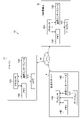
図1は、本実施形態に係る被災情報処理システム10の概略図である。図1に示すように、被災情報処理システム10は、ドローン12と、自治体サーバー14と、消防署端末16と、自治体端末18と、を含んで構成される。 [Overall configuration of disaster information processing system]
FIG. 1 is a schematic diagram of a disasterinformation processing system 10 according to this embodiment. As shown in FIG. 1 , the disaster information processing system 10 includes a drone 12 , a local government server 14 , a fire station terminal 16 and a local government terminal 18 .
図1は、本実施形態に係る被災情報処理システム10の概略図である。図1に示すように、被災情報処理システム10は、ドローン12と、自治体サーバー14と、消防署端末16と、自治体端末18と、を含んで構成される。 [Overall configuration of disaster information processing system]
FIG. 1 is a schematic diagram of a disaster
ドローン12(「第4の端末」の一例)は、自治体サーバー14又は不図示のコントローラによって遠隔操作される無人航空機(UAV:unmanned aerial vehicle、「飛行体」の一例)である。ドローン12は、予め定められたプログラムに従って飛行するオートパイロット機能を有していてもよい。ドローン12は、例えば大規模災害が発生した際に上空から地上を撮影し、建物を含む空撮画像(高所画像)を取得する。建物とは、「戸建住宅」及び「集合住宅」等の住家を指すが、「店舗」、「事務所」、及び「工場」等の建築物全般を含んでもよい。以下においては、建物について種類を区別することなく「家屋」と表記する。
The drone 12 (an example of a "fourth terminal") is an unmanned aerial vehicle (UAV: unmanned aerial vehicle, an example of a "flying object") remotely controlled by the local government server 14 or a controller (not shown). Drone 12 may have an autopilot function that flies according to a predetermined program. For example, when a large-scale disaster occurs, the drone 12 captures an image of the ground from above to obtain an aerial image (high-altitude image) including buildings. Buildings refer to dwellings such as "single-family homes" and "multi-family housing," but may also include general buildings such as "stores," "offices," and "factories." In the following, buildings are referred to as "houses" without distinguishing between types.
自治体サーバー14は、自治体の庁舎内であって、住家被害認定調査にかかわる部署に設置される。自治体サーバー14は、少なくとも1つのコンピュータで実現され、被災情報処理装置を構成する。自治体サーバー14は、クラウドシステムにより提供されるクラウドサーバーであってもよい。
The local government server 14 is installed in the department involved in the housing damage certification survey within the government building of the local government. The local government server 14 is realized by at least one computer and constitutes a disaster information processing device. The municipality server 14 may be a cloud server provided by a cloud system.
消防署端末16は、火災(「第1の被災原因」の一例)を管轄する組織である消防署であって、自治体サーバー14が設置される自治体と関連する消防署内に設置される。消防署端末16(「第1の端末」の一例)は、少なくとも1つのコンピュータで実現され、被災情報処理装置を構成する。
The fire department terminal 16 is installed in a fire department that is an organization that has jurisdiction over fires (an example of a "first cause of damage") and is associated with the municipality where the municipality server 14 is installed. The fire station terminal 16 (an example of a "first terminal") is realized by at least one computer and constitutes a disaster information processing device.
自治体端末18は、自治体の庁舎内であって、自治体サーバー14が設置される部署とは異なる部署内に設置される。自治体端末18は、少なくとも1つのコンピュータで実現され、通信ネットワーク20に接続される。自治体端末18は、自治体の出先機関に設置されていてもよい。
The local government terminal 18 is installed in a department different from the department in which the local government server 14 is installed, inside the government building of the local government. The municipality terminal 18 is realized by at least one computer and connected to the communication network 20 . The local government terminal 18 may be installed at a branch office of the local government.
ドローン12と、自治体サーバー14と、消防署端末16と、自治体端末18とは、それぞれ2.4GHz帯無線LAN(Local Area Network)等の通信ネットワーク20を介してデータを送受信可能に接続される。
The drone 12, the local government server 14, the fire station terminal 16, and the local government terminal 18 are each connected via a communication network 20 such as a 2.4 GHz band wireless LAN (Local Area Network) so that data can be transmitted and received.
なお、ドローン12と、自治体サーバー14と、消防署端末16と、自治体端末18とは、それぞれデータのやり取りが可能であればよく、直接データを送受信可能に接続されていなくてもよい。例えば、不図示のデータサーバを介してデータのやり取りを行ってもよい。
Note that the drone 12, the local government server 14, the fire station terminal 16, and the local government terminal 18 need only be able to exchange data, and do not have to be directly connected so that data can be sent and received. For example, data may be exchanged via a data server (not shown).
〔被災情報処理システムの電気的構成〕
図2は、被災情報処理システム10の電気的構成を示すブロック図である。図2に示すように、ドローン12は、プロセッサ12Aと、メモリ12Bと、カメラ12Cと、通信インターフェース12Dと、を含む。 [Electrical Configuration of Damage Information Processing System]
FIG. 2 is a block diagram showing an electrical configuration of the disasterinformation processing system 10. As shown in FIG. As shown in FIG. 2, drone 12 includes processor 12A, memory 12B, camera 12C, and communication interface 12D.
図2は、被災情報処理システム10の電気的構成を示すブロック図である。図2に示すように、ドローン12は、プロセッサ12Aと、メモリ12Bと、カメラ12Cと、通信インターフェース12Dと、を含む。 [Electrical Configuration of Damage Information Processing System]
FIG. 2 is a block diagram showing an electrical configuration of the disaster
プロセッサ12A(「第3のプロセッサ」の一例)は、メモリ12Bに記憶された命令を実行する。プロセッサ12Aのハードウェア的な構造は、次に示すような各種のプロセッサ(processor)である。各種のプロセッサには、ソフトウェア(プログラム)を実行して各種の機能部として作用する汎用的なプロセッサであるCPU(Central Processing Unit)、画像処理に特化したプロセッサであるGPU(Graphics Processing Unit)、FPGA(Field Programmable Gate Array)等の製造後に回路構成を変更可能なプロセッサであるPLD(Programmable Logic Device)、ASIC(Application Specific Integrated Circuit)等の特定の処理を実行させるために専用に設計された回路構成を有するプロセッサである専用電気回路等が含まれる。
The processor 12A (an example of a "third processor") executes instructions stored in the memory 12B. The hardware structure of the processor 12A is various processors as shown below. Various processors include a CPU (Central Processing Unit), which is a general-purpose processor that executes software (programs) and acts as various functional units, a GPU (Graphics Processing Unit), which is a processor specialized for image processing, A circuit specially designed to execute specific processing such as PLD (Programmable Logic Device), which is a processor whose circuit configuration can be changed after manufacturing such as FPGA (Field Programmable Gate Array), ASIC (Application Specific Integrated Circuit), etc. Also included are dedicated electrical circuits, which are processors with configuration, and the like.
1つの処理部は、これら各種のプロセッサのうちの1つで構成されていてもよいし、同種又は異種の2つ以上のプロセッサ(例えば、複数のFPGA、又はCPUとFPGAの組み合わせ、あるいはCPUとGPUの組み合わせ)で構成されてもよい。また、複数の機能部を1つのプロセッサで構成してもよい。複数の機能部を1つのプロセッサで構成する例としては、第1に、クライアント又はサーバー等のコンピュータに代表されるように、1つ以上のCPUとソフトウェアの組合せで1つのプロセッサを構成し、このプロセッサが複数の機能部として作用させる形態がある。第2に、SoC(System On Chip)等に代表されるように、複数の機能部を含むシステム全体の機能を1つのIC(Integrated Circuit)チップで実現するプロセッサを使用する形態がある。このように、各種の機能部は、ハードウェア的な構造として、上記各種のプロセッサを1つ以上用いて構成される。
One processing unit may be composed of one of these various processors, or two or more processors of the same or different type (for example, a plurality of FPGAs, a combination of CPU and FPGA, or a combination of CPU and GPU). Also, a plurality of functional units may be configured by one processor. As an example of configuring a plurality of functional units in a single processor, first, as represented by a computer such as a client or server, a single processor is configured by combining one or more CPUs and software. There is a form in which a processor acts as a plurality of functional units. Secondly, as typified by SoC (System On Chip), etc., there is a mode of using a processor that realizes the functions of the entire system including multiple functional units with a single IC (Integrated Circuit) chip. In this way, various functional units are configured using one or more of the above various processors as a hardware structure.
さらに、これらの各種のプロセッサのハードウェア的な構造は、より具体的には、半導体素子等の回路素子を組み合わせた電気回路(circuitry)である。
Furthermore, the hardware structure of these various processors is, more specifically, an electrical circuit that combines circuit elements such as semiconductor elements.
メモリ12B(「第3のメモリ」の一例)は、プロセッサ12Aに実行させるための命令を記憶する。メモリ12Bは、不図示のRAM(Random Access Memory)、及びROM(Read Only Memory)を含む。プロセッサ12Aは、RAMを作業領域とし、ROMに記憶された各種のプログラム及びパラメータを使用してソフトウェアを実行し、かつROM等に記憶されたパラメータを使用することで、ドローン12の各種の処理を実行する。
The memory 12B (an example of a "third memory") stores instructions to be executed by the processor 12A. The memory 12B includes RAM (Random Access Memory) and ROM (Read Only Memory), not shown. The processor 12A uses the RAM as a work area, executes software using various programs and parameters stored in the ROM, and uses the parameters stored in the ROM or the like to perform various processes of the drone 12. Run.
カメラ12Cは、不図示のレンズ及び不図示の撮像素子を備える。カメラ12Cは、不図示のジンバルを介してドローン12に支持される。カメラ12Cのレンズは、受光した被写体光を撮像素子の結像面に結像させる。カメラ12Cの撮像素子は、結像面に結像した被写体光を受光して被写体の画像信号を出力する。
The camera 12C includes a lens (not shown) and an imaging device (not shown). The camera 12C is supported by the drone 12 via gimbals (not shown). The lens of the camera 12C forms an image of the received subject light on the imaging plane of the imaging element. The imaging element of the camera 12C receives the subject light imaged on the imaging plane and outputs an image signal of the subject.
カメラ12Cは、不図示のジャイロセンサーによってレンズの光軸のロール軸、ピッチ軸、及びヨー軸の角度を取得してもよい。
The camera 12C may acquire the angles of the roll axis, pitch axis, and yaw axis of the optical axis of the lens using a gyro sensor (not shown).
通信インターフェース12Dは、通信ネットワーク20を介した通信を制御する。
The communication interface 12D controls communication via the communication network 20.
ドローン12は、不図示のGPS(Global Positioning System)受信機、気圧センサー、方位センサー、及びジャイロセンサー等を備えてもよい。
The drone 12 may include a GPS (Global Positioning System) receiver, an air pressure sensor, an orientation sensor, a gyro sensor, etc. (not shown).
また、図2に示すように、自治体サーバー14は、プロセッサ14Aと、メモリ14Bと、ディスプレイ14Cと、通信インターフェース14Dと、を含む。消防署端末16は、プロセッサ16Aと、メモリ16Bと、ディスプレイ16Cと、通信インターフェース16Dと、を含む。
Also, as shown in FIG. 2, the municipality server 14 includes a processor 14A, a memory 14B, a display 14C, and a communication interface 14D. Fire department terminal 16 includes processor 16A, memory 16B, display 16C, and communication interface 16D.
プロセッサ14A(「第2のプロセッサ」の一例)、及びプロセッサ16A(「第1のプロセッサ」の一例)の構成は、プロセッサ12Aの構成と同様である。また、メモリ14B(「第2のメモリ」の一例)、及びメモリ16B(「第1のメモリ」の一例)の構成は、メモリ12Bの構成と同様である。
The configuration of the processor 14A (an example of the "second processor") and the processor 16A (an example of the "first processor") is the same as the configuration of the processor 12A. Also, the configurations of the memory 14B (an example of the "second memory") and the memory 16B (an example of the "first memory") are the same as the configuration of the memory 12B.
ディスプレイ14Cは、被災情報処理システム10において処理される情報を自治体の職員(ユーザ)に視認させるための表示装置である。ディスプレイ14Cとしては、大画面プラズマディスプレイ、又は複数のディスプレイをつなぎ合わせた多面マルチディスプレイ等を適用することができる。また、ディスプレイ14Cは、スクリーンに映像を投影するプロジェクタを含む。
The display 14C is a display device for making the information processed by the disaster information processing system 10 visible to the staff (user) of the local government. As the display 14C, a large-screen plasma display, or a multi-screen multi-display in which a plurality of displays are joined together, or the like can be applied. The display 14C also includes a projector that projects an image onto the screen.
ディスプレイ16C(「第1のディスプレイ」の一例)は、被災情報処理システム10において処理される情報を消防署の職員に視認させるための表示装置である。ディスプレイ16Cの構成は、ディスプレイ14Cと同様である。
The display 16C (an example of the "first display") is a display device for allowing fire department personnel to view information processed in the disaster information processing system 10. The configuration of the display 16C is similar to that of the display 14C.
通信インターフェース14D及び通信インターフェース16Dの構成は、通信インターフェース12Dと同様である。
The configurations of the communication interface 14D and the communication interface 16D are the same as the communication interface 12D.
また、図2では図示を省略しているが、自治体端末18の構成は、消防署端末16と同様である。
Although not shown in FIG. 2, the configuration of the local government terminal 18 is similar to that of the fire station terminal 16.
〔被災情報処理システムの機能的構成〕
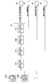
図3は、被災情報処理システム10の機能ブロック図である。図3に示すように、被災情報処理システム10は、家屋検出部30と、被災判定部32と、被災種別振分部34と、焼失家屋集計部36と、焼失家屋情報表示部38と、焼失家屋情報通知部40と、を備える。 [Functional configuration of disaster information processing system]
FIG. 3 is a functional block diagram of the disasterinformation processing system 10. As shown in FIG. As shown in FIG. 3, the disaster information processing system 10 includes a house detection unit 30, a damage determination unit 32, a damage classification unit 34, a burnt house totalization unit 36, a burnt house information display unit 38, and a burnt house information display unit 38. and a house information notification unit 40 .
図3は、被災情報処理システム10の機能ブロック図である。図3に示すように、被災情報処理システム10は、家屋検出部30と、被災判定部32と、被災種別振分部34と、焼失家屋集計部36と、焼失家屋情報表示部38と、焼失家屋情報通知部40と、を備える。 [Functional configuration of disaster information processing system]
FIG. 3 is a functional block diagram of the disaster
家屋検出部30の機能は、プロセッサ12Aによって実現される。また、被災判定部32と、被災種別振分部34と、焼失家屋集計部36と、焼失家屋情報表示部38と、焼失家屋情報通知部40との機能は、プロセッサ14Aによって実現される。これらのすべての機能をプロセッサ12A及びプロセッサ14Aのいずれかによって実現させてもよい。また、被災情報処理システム10は、複数のプロセッサによって実現される「被災情報処理装置」として解釈されてもよい。
The functions of the house detection unit 30 are implemented by the processor 12A. Moreover, the functions of the disaster determination unit 32, the disaster type sorting unit 34, the burnt house counting unit 36, the burnt house information display unit 38, and the burnt house information notification unit 40 are realized by the processor 14A. All these functions may be implemented by either processor 12A or processor 14A. Moreover, the disaster information processing system 10 may be interpreted as a "disaster information processing device" implemented by a plurality of processors.
家屋検出部30は、カメラ12Cから取得した高所画像に含まれる家屋の領域を検出し、検出した家屋の領域をそれぞれ切り出して家屋切出画像を生成する。家屋検出部30は、高所画像と、高所画像によって撮影された地域の家屋領域情報(「建物領域情報」の一例)とから、家屋の領域を検出する。家屋領域情報は、家屋の境界線情報、家屋の位置情報、及び家屋の住所情報のうちの少なくとも1つを含む情報である。家屋の境界線情報は、ポリゴン情報であってもよい。家屋のポリゴン情報は、家屋の外周形状データ、家屋の高さデータ、及び土地の標高データから生成される。家屋の位置情報は、緯度及び経度の情報を含む。家屋の住所情報は、都道府県、区市町村、町域、丁目、及び番地の情報を含む。家屋領域情報は、メモリ12Bに記憶されている。
The house detection unit 30 detects a house area included in the high-altitude image acquired from the camera 12C, cuts out each of the detected house areas, and generates a house cutout image. The house detection unit 30 detects a house area from the high-altitude image and house area information (an example of "building area information") of the area captured by the high-altitude image. The house area information is information including at least one of house boundary line information, house position information, and house address information. The house boundary line information may be polygon information. House polygon information is generated from house outer shape data, house height data, and land elevation data. The house location information includes latitude and longitude information. The house address information includes information on prefectures, municipalities, town areas, chomes, and street numbers. The house area information is stored in the memory 12B.
被災判定部32は、家屋切出画像に含まれる家屋が被災しているか否かを判定(識別)する。家屋が被災しているとは、災害により家屋に被害が発生していること指す。被災判定部32は、被災判定AI(Artificial Intelligence)32Aを備える。
The damage determination unit 32 determines (identifies) whether or not the house included in the cut-out image of the house is damaged. The fact that the house is damaged means that the house is damaged by the disaster. The disaster determination unit 32 includes a disaster determination AI (Artificial Intelligence) 32A.
被災判定AI32A(「第2の学習済みモデル」の一例)は、家屋切出画像を入力として与えると家屋切出画像に含まれる家屋が被災しているか否かを出力する学習済みモデルである。被災判定AI32Aは、家屋の領域が切り出された家屋切出画像と、家屋切出画像に含まれる家屋の被災の有無とをセットとする学習用の学習データセットにより機械学習が行われたものである。被災判定AI32Aは、畳み込みニューラルネットワーク(CNN:Convolution Neural Network)を適用することができる。
The damage determination AI32A (an example of the "second learned model") is a learned model that outputs whether or not the house included in the cut-out house image is damaged when given the cut-out image of the house as an input. The damage judgment AI32A is machine learning based on a learning data set for learning, which is a set of a cut-out image of a house from which the region of the house is cut out and whether or not the house is damaged in the cut-out image of the house. be. The disaster determination AI 32A can apply a convolution neural network (CNN: Convolution Neural Network).
被災種別振分部34は、家屋が被災していると判定された家屋切出画像の家屋の被災種別を振り分け、家屋切出画像から火災(「第1の被災原因」の一例)により被災した焼失家屋(「第1の被災建物」の一例)を抽出し、かつ家屋切出画像から倒壊(「第2の被災原因」の一例)により被災した倒壊家屋(「第2の被災建物」の一例)を抽出する。
The damage type sorting unit 34 sorts the damage type of the house in the cutout image of the house determined to be damaged, and determines whether the house was damaged by fire (an example of the “first cause of damage”) from the cutout image of the house. A burnt house (an example of a “first damaged building”) is extracted, and a collapsed house damaged by a collapse (an example of a “second cause of damage”) (an example of a “second damaged building”) is extracted from the cutout image of a house. ).
被災種別振分部34は、焼失検出AI34Aと、倒壊検出AI34Bと、を備える。焼失検出AI34A(「第1の学習済みモデル」の一例)は、家屋切出画像を入力として与えると家屋切出画像に含まれる家屋が焼失しているか否かを出力する学習済みモデルである。家屋が焼失しているとは、火災により家屋に被害が発生していること指し、「全焼」の場合に限られず、「半焼」、「部分焼」、及び「ぼや」を含む。焼失検出AI34Aは、家屋の領域が切り出された家屋切出画像と、家屋切出画像に含まれる家屋の焼失の有無とをセットとする学習用の学習データセットにより機械学習が行われたものである。
The disaster type sorting unit 34 includes a burn detection AI 34A and a collapse detection AI 34B. The burnt-down detection AI 34A (an example of the “first trained model”) is a trained model that outputs whether or not the house included in the cut-out house image is burnt down when given the cut-out image of the house as an input. The term "house destroyed by fire" means that the house is damaged by fire, and includes not only "completely burned" but also "half-burned," "partially burned," and "burned." The burnt-down detection AI34A performs machine learning using a learning data set for learning, which is a set of a cut-out image of the house from which the area of the house has been cut out and the presence or absence of the burnt-down house included in the cut-out image of the house. be.
倒壊検出AI34Bは、家屋切出画像を入力として与えると家屋切出画像に含まれる家屋が倒壊しているか否かを出力する学習済みモデルである。家屋が倒壊しているとは、家屋が破壊されていること指し、「全壊」の場合に限られず、「大規模半壊」、及び「半壊」を含む。倒壊検出AI34Bは、家屋の領域が切り出された家屋切出画像と、家屋切出画像に含まれる家屋の倒壊の有無とをセットとする学習用の学習データセットにより機械学習が行われたものである。焼失検出AI34A及び倒壊検出AI34Bは、畳み込みニューラルネットワークを適用することができる。
The collapse detection AI 34B is a trained model that outputs whether or not the house included in the cutout image of the house has collapsed when given the cutout image of the house as an input. A collapsed house means that the house is destroyed, and includes not only "total collapse" but also "large-scale partial collapse" and "partial collapse". The collapse detection AI 34B performs machine learning using a learning data set for learning, which is a set of a cut-out image of a house from which the area of the house has been cut out and the presence or absence of collapse of the house included in the cut-out image of the house. be. The burn detection AI 34A and the collapse detection AI 34B can apply convolutional neural networks.
焼失家屋集計部36は、被災種別振分部34によって家屋が焼失していると判定された家屋(焼失家屋)の数を集計(「算出」の一例)する。
The burnt house tallying unit 36 tallies (an example of "calculation") the number of houses determined to be burnt down by the disaster classification unit 34 (burnt houses).
焼失家屋情報表示部38は、被災種別振分部34により振り分けられた焼失家屋に関する被災情報であって、焼失家屋集計部36が集計した焼失家屋の数を含む被災情報のうちの少なくとも一部を、ディスプレイ14Cに表示させる。被災情報は、焼失家屋の画像、位置情報、及び住所情報のうちの少なくとも1つを含む。
The burnt house information display unit 38 displays at least part of the damage information related to the burnt houses sorted by the disaster type sorting unit 34 and including the number of burnt houses tallied by the burnt house tallying unit 36. , is displayed on the display 14C. The disaster information includes at least one of an image of the burnt-down house, location information, and address information.
焼失家屋情報通知部40は、被災種別振分部34により振り分けられた焼失家屋に関する被災情報であって、焼失家屋集計部36が集計した焼失家屋の数を含む被災情報(「第1の被災情報」の一例)のうちの少なくとも一部を、火災と関連付けられた消防署端末16に対して通知(「提供」の一例)する。
The burnt house information notification unit 40 receives damage information related to burnt houses sorted by the disaster type sorting unit 34 and including the number of burnt houses aggregated by the burnt house aggregation unit 36 (“first disaster information ”) is notified (an example of “providing”) to the fire department terminal 16 associated with the fire.
なお、被災情報処理システム10は、自治体サーバー14が消防署端末16に対して被災情報を提供できればよく、必ずしも自治体サーバー14が消防署端末16に直接被災情報を通知しなくてもよい。例えば、自治体サーバー14が不図示のサーバーに被災情報をアップロードし、消防署端末16が不図示のサーバーから被災情報をダウンロードしてもよい。
In the disaster information processing system 10, it is sufficient if the local government server 14 can provide disaster information to the fire department terminal 16, and the local government server 14 does not necessarily have to directly notify the fire department terminal 16 of the disaster information. For example, the local government server 14 may upload the disaster information to a server (not shown), and the fire station terminal 16 may download the disaster information from the server (not shown).
〔被災情報処理方法〕
図4は、被災情報処理システム10による被災情報処理方法の各工程を示すフローチャートである。また、図5は、被災情報処理方法の各工程におけるプロセス図である。被災情報処理方法は、プロセッサ14Aがメモリ14Bに記憶された被災情報処理プログラムを実行することで実現される。被災情報処理プログラムは、コンピュータが読み取り可能な非一時的記憶媒体によって提供されてもよい。この場合、自治体サーバー14は、非一時的記憶媒体から被災情報処理プログラムを読み取り、メモリ14Bに記憶させてもよい。 [Damage information processing method]
FIG. 4 is a flow chart showing each step of the disaster information processing method by the disasterinformation processing system 10. As shown in FIG. Moreover, FIG. 5 is a process diagram in each process of the disaster information processing method. The disaster information processing method is implemented by causing the processor 14A to execute a disaster information processing program stored in the memory 14B. The disaster information processing program may be provided by a computer-readable non-temporary storage medium. In this case, the local government server 14 may read the disaster information processing program from the non-temporary storage medium and store it in the memory 14B.
図4は、被災情報処理システム10による被災情報処理方法の各工程を示すフローチャートである。また、図5は、被災情報処理方法の各工程におけるプロセス図である。被災情報処理方法は、プロセッサ14Aがメモリ14Bに記憶された被災情報処理プログラムを実行することで実現される。被災情報処理プログラムは、コンピュータが読み取り可能な非一時的記憶媒体によって提供されてもよい。この場合、自治体サーバー14は、非一時的記憶媒体から被災情報処理プログラムを読み取り、メモリ14Bに記憶させてもよい。 [Damage information processing method]
FIG. 4 is a flow chart showing each step of the disaster information processing method by the disaster
ステップS1(「画像取得工程」の一例)では、ドローン12は、自治体サーバー14の指示に従って大規模災害直後に街の上空を飛行し、カメラ12Cによって家屋を含む高所画像を撮影する。
In step S1 (an example of the "image acquisition process"), the drone 12 flies over the city immediately after the large-scale disaster according to the instructions of the local government server 14, and captures high-altitude images including houses with the camera 12C.
ステップS2(「第1の被災建物抽出工程」の一例)では、被災情報処理システム10は、高所画像から焼失家屋(「第1の被災家屋」の一例)を抽出する。まず、ドローン12のプロセッサ12Aの家屋検出部30は、メモリ12Bから取得した家屋領域情報に基づいて、ステップS1で撮影された高所画像から家屋の領域を検出する。
In step S2 (an example of a "first damaged building extraction step"), the disaster information processing system 10 extracts a burnt house (an example of a "first damaged house") from the high-place image. First, the house detection unit 30 of the processor 12A of the drone 12 detects a house area from the high-altitude image captured in step S1 based on the house area information acquired from the memory 12B.
図5に、高所画像100と、高所画像100と同じアングルの家屋領域情報102とを示す。家屋領域情報102は、大規模災害発生前に撮影された高所画像から作成された情報であり、ここでは家屋の外周形状を線で現した情報である。
FIG. 5 shows a high-altitude image 100 and house area information 102 at the same angle as the high-altitude image 100 . The house area information 102 is information created from a high-altitude image taken before the occurrence of a large-scale disaster, and here is information representing the outline shape of a house with lines.
また、図5に、高所画像100と家屋領域情報102とを合成した合成画像104を示す。このような合成画像104を生成することで、家屋検出部30は、合成画像104のうち家屋領域情報102の線によって囲まれた領域が家屋であると認識することができる。
Also, FIG. 5 shows a synthesized image 104 obtained by synthesizing the high place image 100 and the house area information 102 . By generating such a composite image 104, the house detection unit 30 can recognize that the area surrounded by lines in the house area information 102 in the composite image 104 is a house.
家屋検出部30は、合成画像104によって検出した家屋の領域を高所画像100からそれぞれ切り出して家屋切出画像を生成する。図5に、家屋切出画像106A、106B、…を示す。家屋切出画像は、検出した家屋の数だけ生成される。
The house detection unit 30 cuts out the house areas detected by the composite image 104 from the high-altitude image 100 to generate house cutout images. FIG. 5 shows house clipped images 106A, 106B, . . . House cutout images are generated by the number of houses detected.
ドローン12は、家屋切出画像106A、106B、…を通信インターフェース12Dによって通信ネットワーク20を介して自治体サーバー14に送信(「提供」の一例)する。自治体サーバー14は、この家屋切出画像106A、106B、…を通信インターフェース14Dによって受信(「取得」の一例)する。
The drone 12 transmits (an example of "providing") the house cut-out images 106A, 106B, . The municipality server 14 receives (an example of "acquisition") the cut-out house images 106A, 106B, . . . through the communication interface 14D.
次に、自治体サーバー14のプロセッサ14Aの被災判定部32は、複数の家屋切出画像を順に被災判定AI32Aに入力し、各家屋切出画像に含まれる家屋が被災しているか否かをそれぞれ判定する。すなわち、被災判定部32では、複数の家屋切出画像のうち、家屋が被災している家屋切出画像と、家屋が被災していない家屋切出画像とを選別する。図5は、家屋切出画像106A、106B、…を被災判定AI32Aに入力する例を示している。
Next, the damage determination unit 32 of the processor 14A of the municipality server 14 sequentially inputs the plurality of cut-out house images to the damage determination AI 32A, and determines whether or not the house included in each cut-out house image is damaged. do. That is, the damage determination unit 32 selects, from among the plurality of house cutout images, house cutout images in which the house is damaged and house cutout images in which the house is not damaged. FIG. 5 shows an example of inputting cut-out house images 106A, 106B, . . . to the disaster determination AI 32A.
続いて、被災種別振分部34は、複数の家屋切出画像のうち、被災判定部32において家屋が被災していると判定された家屋切出画像を順に焼失検出AI34Aに入力し、各家屋切出画像に含まれる家屋が焼失しているか否かをそれぞれ判定する。すなわち、焼失検出AI34Aは、家屋が焼失している家屋切出画像と、家屋が焼失していない家屋切出画像とを選別する。
Subsequently, the damage type sorting unit 34 sequentially inputs the cut-out house images, among the multiple cut-out house images, for which the damage determination unit 32 determines that the house is damaged, to the burnt-down detection AI 34A, and It is determined whether or not the house included in the clipped image has been destroyed by fire. That is, the burnt-down detection AI 34A sorts out a house cut-out image in which the house is burnt down and a house cut-out image in which the house is not burnt down.
また、被災種別振分部34は、複数の家屋切出画像のうち、被災判定部32において家屋が被災していると判定された家屋切出画像であって、焼失検出AI34Aにおいて家屋が焼失していないと判定された家屋切出画像を順に倒壊検出AI34Bに入力し、各家屋切出画像に含まれる家屋が倒壊しているか否かをそれぞれ判定する。すなわち、倒壊検出AI34Bは、家屋が倒壊している家屋切出画像と、家屋が倒壊していない家屋切出画像とを選別する。
In addition, the damage classification unit 34 selects a house cut-out image for which the damage determination unit 32 has determined that the house has been damaged among the plurality of house cut-out images, and which has been destroyed by fire in the burn-down detection AI 34A. The house cut-out images determined not to be collapsed are sequentially input to the collapse detection AI 34B, and it is determined whether or not the house included in each house cut-out image is collapsed. That is, the collapse detection AI 34B sorts out a house clipped image in which the house is collapsed and a house clipped image in which the house is not collapsed.
このように、被災種別振分部34では、家屋が被災している複数の家屋切出画像のうち、家屋が焼失している家屋切出画像と、家屋が倒壊している家屋切出画像と、焼失及び倒壊以外の被災の家屋切出画像と、を選別する。したがって被災情報処理システム10は、高所画像から焼失家屋を抽出することができる。図5は、家屋切出画像を焼失検出AI34Aと倒壊検出AI34Bとに入力する例を示している。
In this way, the damage type sorting unit 34 selects, among a plurality of house cutout images in which a house is damaged, a house cutout image in which a house has been destroyed by fire and a house cutout image in which a house has collapsed. , and cropped images of damaged houses other than burnt down and collapsed houses. Therefore, the disaster information processing system 10 can extract burnt houses from high-place images. FIG. 5 shows an example of inputting a cut-out image of a house to the burnt-down detection AI 34A and the collapse detection AI 34B.
ここでは、被災種別振分部34において、家屋が焼失しているか否かを判定した後に家屋が倒壊しているか否かを判定したが、焼失家屋と倒壊家屋の振り分ける順は逆でもよい。すなわち、被災種別振分部34は、家屋が倒壊しているか否かを判定した後に家屋が焼失しているか否かを判定してもよい。
Here, in the disaster type sorting unit 34, it is determined whether or not the house is destroyed after determining whether or not the house is destroyed by fire, but the order of sorting burnt houses and collapsed houses may be reversed. That is, the disaster type sorting unit 34 may determine whether the house has been destroyed by fire after determining whether the house has collapsed.
また、被災判定部32において家屋切出画像に含まれる家屋が被災しているか否かを判定し、家屋が被災していると判定された家屋切出画像について、被災種別振分部34において被災の種別を選別したが、被災判定部32と被災種別振分部34との処理は逆でもよい。すなわち、被災種別振分部34において家屋切出画像に含まれる家屋の被災の種別を選別し、いずれにも選別されなかった家屋切出画像について、被災判定部32において家屋が被災しているか否かを判定してもよい。
In addition, the damage determination unit 32 determines whether or not the house included in the cut-out house image is damaged. However, the processes of the disaster determination unit 32 and the disaster type sorting unit 34 may be reversed. That is, the damage classification unit 34 sorts out the types of damage to the houses included in the cut-out house images, and for the cut-out house images that are not sorted, the damage determination unit 32 decides whether or not the house is damaged. It may be determined whether
次に、ステップS3(「算出工程」の一例)では、焼失家屋集計部36は、高所画像に含まれる焼失家屋の数を集計する。焼失家屋の数は、ステップS2の焼失検出AI34Aの処理において家屋が焼失していると判定された家屋切出画像の数に相当する。焼失家屋集計部36は、焼失家屋の数の集計とともに高所画像に含まれる倒壊家屋(「第2の被災家屋」の一例)の数を集計してもよい。
Next, in step S3 (an example of the "calculation process"), the burnt-down house tallying unit 36 tallies the number of burnt-down houses included in the high-place image. The number of burnt houses corresponds to the number of cutout images of houses determined to be burnt down in the process of the burnt house detection AI 34A in step S2. The burnt house tallying unit 36 may tally the number of collapsed houses (an example of the “second damaged house”) included in the high place image together with the tallying of the number of burnt houses.
最後に、ステップS4(「提供工程」の一例)では、焼失家屋情報通知部40は、ステップS2で抽出された焼失家屋に関する被災情報(「第1の被災情報」の一例)を消防署端末16に対して通信インターフェース14Dによって通知する。被災情報は、ステップS3で集計された焼失家屋の数を含む。焼失家屋情報通知部40は、被災情報のうちの少なくとも一部を消防署端末16に対して通知してもよい。
Finally, in step S4 (an example of a "providing step"), the burnt-down house information notification unit 40 sends damage information (an example of "first damage information") related to the burnt-down house extracted in step S2 to the fire station terminal 16. It is notified by the communication interface 14D. The damage information includes the number of burnt houses counted in step S3. The burnt house information notification unit 40 may notify the fire station terminal 16 of at least part of the disaster information.
焼失家屋情報表示部38は、被災情報のうちの少なくとも一部をディスプレイ14Cに表示させてもよい。焼失家屋情報通知部40は、ステップS2で判別された倒壊家屋に関する被災情報であって、ステップS3で集計された倒壊家屋の数を含む被災情報(「第2の被災情報」の一例)のうちの少なくとも一部を自治体端末18(「第2の端末」の一例)に対して通知してもよい。焼失家屋情報表示部38は、この被災情報のうちの少なくとも一部をディスプレイ14Cに表示させてもよい。
The burnt house information display unit 38 may display at least part of the disaster information on the display 14C. The burnt-down house information notification unit 40 is the damage information relating to the collapsed houses determined in step S2 and includes the number of collapsed houses aggregated in step S3 (an example of "second damage information"). may be notified to the local government terminal 18 (an example of the “second terminal”). The burnt house information display unit 38 may display at least part of this disaster information on the display 14C.
消防署端末16のプロセッサ16Aは、焼失家屋情報通知部40から送信された被災情報を通信インターフェース16Dによって受信し、ディスプレイ16Cに表示させる。これにより、消防署の職員は、高所画像に含まれる焼失家屋の情報を視認することが可能となる。
The processor 16A of the fire department terminal 16 receives the disaster information transmitted from the burnt house information notification unit 40 through the communication interface 16D and displays it on the display 16C. As a result, the fire department staff can visually recognize the information on the burnt-down house included in the high-altitude image.
また、自治体サーバー14のプロセッサ14Aは、ステップS2で判別された倒壊家屋に関する被災情報であって、ステップS3で集計された倒壊家屋の数を含む被災情報のうちの少なくとも一部をディスプレイ14Cに表示させてもよい。さらに、自治体サーバー14のプロセッサ14Aは、焼失及び倒壊以外の被災原因の家屋の被災情報のうちの少なくとも一部をディスプレイ14Cに表示させてもよいし、自治体端末18に提供してもよい。
In addition, the processor 14A of the local government server 14 displays at least a part of the damage information regarding the collapsed houses determined in step S2 and including the number of collapsed houses counted in step S3 on the display 14C. You may let Furthermore, the processor 14A of the local government server 14 may display at least a part of the damage information of houses caused by damage other than burning and collapse on the display 14C or may provide it to the local government terminal 18. FIG.
以上のように、被災情報処理システム10によれば、家屋を含む高所画像から火災により被災した家屋の情報を抽出して、火災を管轄する消防署に提供することができる。また、被災情報処理システム10によれば、家屋を含む高所画像から倒壊により被災した家屋の情報を抽出して、倒壊を管轄する自治体の部署に提供することができる。さらに、家屋を含む高所画像から火災及び倒壊以外の被災原因の家屋の情報を抽出して、火災及び倒壊以外の被災原因を管轄する自治体の部署に提供することができるので、被災した家屋の情報を漏れなく提供することができる。
As described above, according to the disaster information processing system 10, it is possible to extract information on houses damaged by fire from high-altitude images including houses, and provide the information to the fire department that has jurisdiction over the fire. In addition, according to the disaster information processing system 10, it is possible to extract information on houses that have been damaged by collapse from high-place images including houses, and to provide the information to the departments of the local government that have jurisdiction over the collapse. Furthermore, it is possible to extract information on houses that have caused damage other than fires and collapses from high-altitude images that include houses, and provide this information to local government departments that have jurisdiction over the causes of damages other than fires and collapses. Information can be provided without omission.
〔地域ごとの被災情報処理方法〕
被災情報処理方法は、地域ごとに行ってもよい。例えば、焼失家屋集計部36は焼失家屋の数を地域ごとに集計し、焼失家屋情報表示部38は焼失家屋の情報を地域ごとに表示し、焼失家屋情報通知部40は地域ごとの被災情報を地域ごとの消防署端末16に対して通知してもよい。地域ごととは、区市町村ごとであってもよいし、町域ごとであってもよいし、丁目ごとであってもよい。 [Damage information processing method for each region]
The disaster information processing method may be performed for each region. For example, the burnthouse tallying unit 36 tallies the number of burnt houses by region, the burnt house information display unit 38 displays information on burnt houses by region, and the burnt house information notification unit 40 displays disaster information by region. You may notify to the fire station terminal 16 for every area. Each region may be for each ward or municipality, may be for each town area, or may be for each chome.
被災情報処理方法は、地域ごとに行ってもよい。例えば、焼失家屋集計部36は焼失家屋の数を地域ごとに集計し、焼失家屋情報表示部38は焼失家屋の情報を地域ごとに表示し、焼失家屋情報通知部40は地域ごとの被災情報を地域ごとの消防署端末16に対して通知してもよい。地域ごととは、区市町村ごとであってもよいし、町域ごとであってもよいし、丁目ごとであってもよい。 [Damage information processing method for each region]
The disaster information processing method may be performed for each region. For example, the burnt
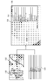
図6は、地域ごとの被災情報処理のプロセス図である。図6に、ある地域の焼失家屋情報110と、丁目領域情報112とを示す。焼失家屋情報110は、焼失家屋の画像、位置情報、及び住所情報のうちの少なくとも1つを含む。また、丁目領域情報112は、焼失家屋情報110の焼失家屋が含まれる高所画像に対応する地域領域情報の一例であり、ここではそれぞれの丁目を構成する境界線が白線で表現された丁目領域情報である。
Fig. 6 is a process diagram of disaster information processing for each region. FIG. 6 shows burnt house information 110 and chome area information 112 in a certain area. The burnt house information 110 includes at least one of an image of the burnt house, position information, and address information. The chome area information 112 is an example of the area area information corresponding to the high-altitude image including the burnt house information 110. Here, the chome area information 112 is represented by white lines representing the boundaries of each chome. Information.
焼失家屋集計部36は、丁目領域情報112を用いて、丁目ごとに集計処理を行う。焼失家屋情報110が住所情報を含まない場合は、境界線情報を使用し、焼失家屋がどの丁目に含まれるかを判定して集計する。
The burnt-down house tabulation unit 36 uses the chome region information 112 to perform tabulation processing for each chome. If the burnt house information 110 does not include address information, the boundary line information is used to determine which chome the burnt house is in and totalize.
図6に、焼失家屋情報表示部38によってディスプレイ14Cにそれぞれ表示される状況把握情報の一例として、丁目ごとの集計結果114及び116と、焼失家屋の住所リスト118と、家屋切出画像120と、住家被害認定調査の作業量の見積もり122と、を示す。
FIG. 6 shows an example of situation grasping information displayed on the display 14C by the burnt-down house information display unit 38, including tabulated results 114 and 116 for each chome, an address list 118 of burnt-out houses, a cut-out image 120 of a house, Estimate 122 of the amount of work for the housing damage certification survey.
集計結果114は、地域の地図であり、丁目ごとの焼失家屋の数に応じてその丁目の領域を色分けして表示されている。例えば、焼失家屋情報表示部38は、焼失家屋の数が相対的に多い丁目を赤色、焼失家屋の数が相対的に少ない丁目を青色に表示する。焼失家屋情報表示部38は、さらにそれぞれの色の領域について、焼失家屋の数が相対的に多いほど濃度を高く表示してもよい。
The tally result 114 is a map of the area, and the chome area is color-coded according to the number of burnt houses in each chome. For example, the burnt-down house information display section 38 displays chomes with a relatively large number of burnt-down houses in red, and chomes with a relatively small number of burnt-down houses in blue. The burnt-down house information display section 38 may also display a higher density for each color area as the number of burnt-down houses is relatively larger.
集計結果116は、集計結果114の一部が拡大された地図である。集計結果116では、丁目の名称と各丁目の焼失家屋の数がそれぞれ表示される。
The tally result 116 is a map in which a part of the tally result 114 is enlarged. The tabulation result 116 displays the name of each chome and the number of burnt houses in each chome.
住所リスト118は、表示された地図からユーザに選択された丁目に含まれる焼失家屋の住所の一覧である。
The address list 118 is a list of addresses of burnt houses included in the chome selected by the user from the displayed map.
家屋切出画像120は、例えば高所画像からユーザに選択された丁目に含まれる焼失家屋の画像である。家屋切出画像120は、住所リスト118からユーザに選択された焼失家屋の画像であってもよい。
The house cutout image 120 is, for example, an image of a burnt house included in the chome selected by the user from the high place image. House clipping image 120 may be an image of a burnt house selected by the user from address list 118 .
見積もり122は、表示された地図からユーザに選択された丁目に含まれる焼失家屋の数と、自治体調査対象家屋の数と、の集計結果を含む。図6に示す例では、調査対象家屋数が91535棟(449269面)であり、そのうち焼失家屋数が12782棟であり、調査対象家屋数のうち焼失家屋数の割合が14%である。見積もり122は、これらの家屋数を表示するとともに、焼失家屋に相当する14%が赤色、それ以外の86%が赤色以外の色で示された円グラフを含む。
The estimate 122 includes the total number of burnt houses in the chome selected by the user from the displayed map and the number of houses surveyed by the local government. In the example shown in FIG. 6, the number of surveyed houses is 91,535 (449,269 houses), of which 12,782 burnt down houses account for 14% of the number of surveyed houses. Estimate 122 includes a pie chart displaying the number of these houses, with 14% corresponding to burnt houses shown in red and the other 86% shown in a color other than red.
これらの状況把握情報は、ディスプレイ16Cに表示されてもよい。
These status comprehension information may be displayed on the display 16C.
〔管轄の消防署へ通知〕
焼失家屋情報通知部40は、丁目ごとの被災情報のうちの少なくとも一部を、丁目をそれぞれ管轄している消防署へ通知してもよい。 [Notify the fire department with jurisdiction]
The burnt-down houseinformation notification unit 40 may notify the fire stations having jurisdiction over each chome of at least a part of the disaster information for each chome.
焼失家屋情報通知部40は、丁目ごとの被災情報のうちの少なくとも一部を、丁目をそれぞれ管轄している消防署へ通知してもよい。 [Notify the fire department with jurisdiction]
The burnt-down house
図7は、管轄の消防署へ通知する処理のプロセス図である。図7に、丁目ごとの集計結果130及び集計結果132と、それぞれの丁目を管轄している消防署情報134と、を示す。
FIG. 7 is a process diagram of the process of notifying the fire department in charge. FIG. 7 shows tabulation results 130 and tabulation results 132 for each chome, and fire station information 134 that has jurisdiction over each chome.
集計結果130及び132は、図6に示した集計結果114及び116と同様である。また、消防署情報134は、丁目の名称と、その丁目を管轄する消防署とがそれぞれ対応付けられている。
The aggregated results 130 and 132 are similar to the aggregated results 114 and 116 shown in FIG. In the fire station information 134, each chome name is associated with the fire station that has jurisdiction over the chome.
また、図7に、地図上で選択された丁目の住所リスト136を示す。住所リスト136は、図6に示した住所リスト118と同様である。焼失家屋情報表示部38は、ユーザの所望の丁目(「地域」の一例)を選択可能にディスプレイ14Cに表示させ、ユーザに選択された丁目の住所リスト136をディスプレイ14Cに表示させる。
Also, FIG. 7 shows an address list 136 of chome selected on the map. Address list 136 is similar to address list 118 shown in FIG. The burnt house information display unit 38 allows the display 14C to selectably display the user's desired chome (an example of "area"), and displays the user-selected chome address list 136 on the display 14C.
また、焼失家屋情報表示部38は、消防署情報134からそれぞれの丁目を管轄している消防署の情報を取得し、丁目ごとの担当消防署を自動で割り当て、担当消防署を表示する。図7に示す例では、住所リスト136の上部に、住所リスト136の丁目を管轄する消防署の名称137と、その消防署に被災情報を通知するためのボタン138と、が表示されている。ユーザが不図示のポインティングデバイス等を用いてボタン138をクリック操作すると、焼失家屋情報通知部40は名称137の消防署の有する消防署端末16に、その丁目に含まれる被災情報を通知する。
In addition, the burnt-down house information display unit 38 acquires the information of the fire station that has jurisdiction over each chome from the fire station information 134, automatically assigns the fire station in charge of each chome, and displays the fire station in charge. In the example shown in FIG. 7, above the address list 136, the name 137 of the fire station that has jurisdiction over the chome of the address list 136 and a button 138 for notifying the fire station of disaster information are displayed. When the user clicks a button 138 using a pointing device (not shown), the burnt house information notification unit 40 notifies the fire station terminal 16 of the fire station with the name 137 of the damage information included in that chome.
〔火災と倒壊以外の被災原因の振り分け〕
ここまでは、被災種別として火災と倒壊とその他との3種類に振り分ける例を説明したが、これ以外の被災種別を振り分けることも可能である。 [Distribution of damage causes other than fire and collapse]
So far, an example has been described in which disaster types are sorted into three types of fire, collapse, and others, but it is also possible to sort by other types of disaster.
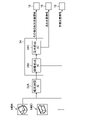
図8は、地震災害の発生により、火災による焼失家屋と、揺れによる倒壊家屋と、内水氾濫による浸水家屋と、が混在する場合の処理のプロセス図である。ここでは、被災種別振分部34は、焼失検出AI34Aと、倒壊検出AI34Bと、浸水検出AI34Cと、を備え、焼失家屋と、倒壊家屋と、浸水家屋と、それ以外の被災家屋と、を振り分ける。
Fig. 8 is a process diagram of processing when houses burnt down by fire, houses destroyed by shaking, and houses flooded by inland water are mixed due to the occurrence of an earthquake disaster. Here, the disaster type sorting unit 34 includes a burnt-down detection AI 34A, a collapsed house detection AI 34B, and a flood detection AI 34C, and sorts out burned houses, collapsed houses, flooded houses, and other damaged houses. .
浸水検出AI34Cは、家屋切出画像を入力として与えると家屋切出画像に含まれる家屋が浸水しているか否かを出力する学習済みモデルである。家屋が浸水しているとは、住家の床より上まで浸水する「床上浸水」の場合に限られず、住家の床より下までの「床下浸水」を含む。浸水検出AI34Cは、家屋の領域が切り出された家屋切出画像と、家屋切出画像に含まれる家屋の浸水の有無とをセットとする学習用の学習データセットにより機械学習が行われたものである。
The flood detection AI34C is a trained model that outputs whether or not the house included in the cutout image of the house is flooded when given the cutout image of the house as input. The house being flooded is not limited to "above-floor flooding," in which water reaches above the floor of the dwelling, but also includes "underfloor flooding," down to below the floor of the dwelling. The inundation detection AI34C is machine-learned using a learning data set for learning, which is a set of a cut-out image of a house from which the area of the house is cut out and the presence or absence of flooding in the house included in the cut-out image of the house. be.
図8では、家屋切出画像140A、140B、…を被災判定AI32Aに入力する例を示している。被災判定AI32Aは、各家屋切出画像に含まれる家屋が被災しているか否かをそれぞれ判定する。
FIG. 8 shows an example of inputting the cut-out house images 140A, 140B, . . . The disaster determination AI 32A determines whether or not the house included in each house clipped image is damaged.
被災判定AI32Aにおいて家屋切出画像に含まれる家屋が被災していると判定された家屋切出画像は、被災種別振分部34に入力される。被災種別振分部34は、被災判定部32において家屋が被災していると判定された家屋切出画像を焼失検出AI34Aに入力し、各家屋切出画像に含まれる家屋が焼失しているか否かを判定する。
A cut-out house image determined by the damage determination AI 32A that the house included in the cut-out house image is damaged is input to the disaster classification unit 34 . The damage type sorting unit 34 inputs the cut-out house images determined by the damage determination unit 32 that the house is damaged to the burnt-down detection AI 34A, and determines whether or not the house included in each cut-out house image is burnt down. determine whether
また、被災種別振分部34は、複数の家屋切出画像のうち、被災判定部32において家屋が被災していると判定された家屋切出画像であって、焼失検出AI34Aにおいて家屋が焼失していないと判定された家屋切出画像を倒壊検出AI34Bに入力し、家屋切出画像に含まれる家屋が倒壊しているか否かを判定する。
In addition, the damage classification unit 34 selects a house cut-out image for which the damage determination unit 32 has determined that the house has been damaged among the plurality of house cut-out images, and which has been destroyed by fire in the burn-down detection AI 34A. The cut-out image of the house that is determined not to have collapsed is input to the collapse detection AI 34B, and it is determined whether or not the house included in the cut-out image of the house has collapsed.
さらに、被災種別振分部34は、複数の家屋切出画像のうち、被災判定部32において家屋が被災していると判定された家屋切出画像であって、焼失検出AI34Aにおいて家屋が焼失していないと判定され、かつ倒壊検出AI34Bにおいて家屋が倒壊していないと判定された家屋切出画像を浸水検出AI34Cに入力し、家屋切出画像に含まれる家屋が浸水しているか否かを判定する。
Furthermore, the damage type sorting unit 34 selects a house cut-out image for which the damage determination unit 32 determines that the house is damaged among the plurality of house cut-out images, and the house has been destroyed by fire in the burn-down detection AI 34A. It is determined that the house has not collapsed, and the collapse detection AI 34B determines that the house has not collapsed. do.
すなわち、被災種別振分部34では、家屋が被災している複数の家屋切出画像のうち、家屋が焼失している家屋切出画像と、家屋が倒壊している家屋切出画像と、家屋が浸水している家屋切出画像と、焼失、倒壊、及び浸水以外の被災の家屋切出画像と、を選別することができる。
In other words, the damage type sorting unit 34 divides a plurality of house cut-out images in which a house is damaged, a house cut-out image in which the house is destroyed by fire, a house cut-out image in which the house is destroyed, and a house cut-out image in which the house is destroyed. It is possible to sort out the cutout image of the flooded house and the cutout image of the damaged house other than burnt down, collapsed and flooded.
図8に示す例では、焼失家屋情報を消防署端末16に通知、倒壊家屋情報と家屋が浸水している浸水家屋情報とを自治体端末18に通知、及びその他の被災家屋情報をその他の端末19に通知している。自治体端末18、及びその他の端末19は、「被災原因ごとにそれぞれ関連付けられた第3の端末」の一例である。
In the example shown in FIG. 8, fire station terminal 16 is notified of burnt house information, collapsed house information and flooded house information are notified to municipality terminal 18, and other damaged house information is sent to other terminal 19. I am notifying you. The local government terminal 18 and other terminals 19 are examples of "third terminals associated with each cause of disaster".
図9は、風水害の発生により、暴風による倒壊家屋と、外水氾濫または内水氾濫による浸水家屋とが混在する場合の処理のプロセス図である。ここでは、被災種別振分部34は、倒壊検出AI34Bと、浸水検出AI34Cと、を備え、倒壊家屋と浸水家屋とを振り分ける。
FIG. 9 is a process diagram of processing when houses collapsed due to storm and flooded houses due to flooding of external water or inland water coexist due to the occurrence of wind and flood damage. Here, the disaster type distribution unit 34 includes a collapse detection AI 34B and a flood detection AI 34C, and distributes collapsed houses and flooded houses.
このように、被災情報処理システム10は、災害の状況に応じて被災種別を振り分け、各被災種別を管轄する組織の端末に被災情報を提供することができる。
In this way, the disaster information processing system 10 can sort disaster types according to the situation of the disaster and provide disaster information to the terminals of the organizations that have jurisdiction over each type of disaster.
〔その他〕
ここでは、高所画像としてドローン12に搭載されたカメラ12Cによって街の上空から被災状況を撮影した空撮画像を用いる例を説明したが、高所画像は街中に設置された定点カメラ、又は監視カメラで撮影された画像であってもよい。また、高所画像は、静止衛星(「人工衛星」の一例)によって撮影された衛星画像でもよい。 〔others〕
Here, an example of using an aerial image of the disaster situation captured from above the city by thecamera 12C mounted on the drone 12 as the high-altitude image has been described. It may be an image captured by a camera. Also, the high-altitude image may be a satellite image captured by a geostationary satellite (an example of an “artificial satellite”).
ここでは、高所画像としてドローン12に搭載されたカメラ12Cによって街の上空から被災状況を撮影した空撮画像を用いる例を説明したが、高所画像は街中に設置された定点カメラ、又は監視カメラで撮影された画像であってもよい。また、高所画像は、静止衛星(「人工衛星」の一例)によって撮影された衛星画像でもよい。 〔others〕
Here, an example of using an aerial image of the disaster situation captured from above the city by the
本発明の技術的範囲は、上記の実施形態に記載の範囲には限定されない。各実施形態における構成等は、本発明の趣旨を逸脱しない範囲で、各実施形態間で適宜組み合わせることができる。
The technical scope of the present invention is not limited to the scope described in the above embodiments. Configurations and the like in each embodiment can be appropriately combined between each embodiment without departing from the gist of the present invention.
10…被災情報処理システム
12…ドローン
12A…プロセッサ
12B…メモリ
12C…カメラ
12D…通信インターフェース
14…自治体サーバー
14A…プロセッサ
14B…メモリ
14C…ディスプレイ
14D…通信インターフェース
16…消防署端末
16A…プロセッサ
16B…メモリ
16C…ディスプレイ
16D…通信インターフェース
18…自治体端末
19…その他の端末
20…通信ネットワーク
30…家屋検出部
32…被災判定部
32A…被災判定AI
34…被災種別振分部
34A…焼失検出AI
34B…倒壊検出AI
34C…浸水検出AI
36…焼失家屋集計部
38…焼失家屋情報表示部
40…焼失家屋情報通知部
100…高所画像
102…家屋領域情報
104…合成画像
106A…家屋切出画像
106B…家屋切出画像
110…焼失家屋情報
112…丁目領域情報
114…集計結果
116…集計結果
118…住所リスト
120…家屋切出画像
134…消防署情報
136…住所リスト
137…名称
138…ボタン
140A…家屋切出画像
140B…家屋切出画像
S1~S4…被災情報処理方法の各工程 10... Disasterinformation processing system 12... Drone 12A... Processor 12B... Memory 12C... Camera 12D... Communication interface 14... Local government server 14A... Processor 14B... Memory 14C... Display 14D... Communication interface 16... Fire station terminal 16A... Processor 16B... Memory 16C Display 16D Communication interface 18 Local government terminal 19 Other terminal 20 Communication network 30 House detector 32 Damage determination unit 32A Damage determination AI
34...Disaster classification unit 34A... Burning detection AI
34B... Collapse detection AI
34C: Flood detection AI
36 Burnedhouse tallying unit 38 Burned house information display unit 40 Burned house information notification unit 100 Height image 102 House area information 104 Composite image 106A House cutout image 106B House cutout image 110 Burned house Information 112 Chome area information 114 Aggregation result 116 Aggregation result 118 Address list 120 House cut-out image 134 Fire station information 136 Address list 137 Name 138 Button 140A House cut-out image 140B House cut-out image S1 to S4: Each step of the disaster information processing method
12…ドローン
12A…プロセッサ
12B…メモリ
12C…カメラ
12D…通信インターフェース
14…自治体サーバー
14A…プロセッサ
14B…メモリ
14C…ディスプレイ
14D…通信インターフェース
16…消防署端末
16A…プロセッサ
16B…メモリ
16C…ディスプレイ
16D…通信インターフェース
18…自治体端末
19…その他の端末
20…通信ネットワーク
30…家屋検出部
32…被災判定部
32A…被災判定AI
34…被災種別振分部
34A…焼失検出AI
34B…倒壊検出AI
34C…浸水検出AI
36…焼失家屋集計部
38…焼失家屋情報表示部
40…焼失家屋情報通知部
100…高所画像
102…家屋領域情報
104…合成画像
106A…家屋切出画像
106B…家屋切出画像
110…焼失家屋情報
112…丁目領域情報
114…集計結果
116…集計結果
118…住所リスト
120…家屋切出画像
134…消防署情報
136…住所リスト
137…名称
138…ボタン
140A…家屋切出画像
140B…家屋切出画像
S1~S4…被災情報処理方法の各工程 10... Disaster
34...
34B... Collapse detection AI
34C: Flood detection AI
36 Burned
Claims (18)
- 少なくとも1つのプロセッサと、
前記少なくとも1つのプロセッサに実行させるための命令を記憶する少なくとも1つのメモリと、
を備え、
前記少なくとも1つのプロセッサは、
建物を含む画像を取得し、
前記取得した画像から第1の被災原因により被災した第1の被災建物を抽出し、
前記抽出した第1の被災建物の数を算出し、
前記抽出した第1の被災建物に関する第1の被災情報であって、前記算出した第1の被災建物の数を含む第1の被災情報のうちの少なくとも一部を前記第1の被災原因と関連付けられた第1の端末に対して提供する、
被災情報処理装置。 at least one processor;
at least one memory storing instructions for execution by the at least one processor;
with
The at least one processor
Get an image containing buildings,
Extracting a first damaged building damaged by a first cause of damage from the acquired image,
calculating the number of extracted first damaged buildings;
At least a part of the extracted first damage information related to the first damaged building including the calculated number of first damaged buildings is associated with the first cause of damage. provided to the first terminal that was
Damage information processing device. - 前記少なくとも1つのプロセッサは、
前記抽出した第1の被災建物の数を地域ごとに算出し、
前記地域ごとに算出した第1の被災建物の数を含む前記地域ごとの第1の被災情報のうちの少なくとも一部を前記第1の端末に対して提供する、
請求項1に記載の被災情報処理装置。 The at least one processor
calculating the number of extracted first damaged buildings for each region;
providing to the first terminal at least part of the first disaster information for each region, including the first number of damaged buildings calculated for each region;
The disaster information processing apparatus according to claim 1. - 前記少なくとも1つのプロセッサは、
前記第1の被災原因と関連付けられた前記地域ごとの第1の端末の情報を取得し、
前記地域ごとの第1の被災情報のうちの少なくとも一部を前記地域ごとに関連付けられた第1の端末に対してそれぞれ提供する、
請求項2に記載の被災情報処理装置。 The at least one processor
Acquiring information of the first terminal for each region associated with the first disaster cause,
providing at least part of the first disaster information for each region to the first terminals associated with each region;
The disaster information processing apparatus according to claim 2. - 前記少なくとも1つのプロセッサは、
前記地域をユーザが選択可能にディスプレイに表示させ、
前記ユーザに選択された地域の第1の被災情報のうちの少なくとも一部を前記ユーザに選択された地域に関連付けられた第1の端末に対して提供する、
請求項2に記載の被災情報処理装置。 The at least one processor
displaying the region on a display so that the user can select it;
providing at least part of the first disaster information of the area selected by the user to a first terminal associated with the area selected by the user;
The disaster information processing apparatus according to claim 2. - 前記少なくとも1つのプロセッサは、
前記取得した画像に対応する地域領域情報を取得し、
前記取得した地域領域情報を用いて前記地域ごとの第1の被災情報を取得する、
請求項2から4のいずれか1項に記載の被災情報処理装置。 The at least one processor
obtaining regional area information corresponding to the obtained image;
obtaining first disaster information for each region using the obtained regional area information;
A disaster information processing apparatus according to any one of claims 2 to 4. - 前記少なくとも1つのプロセッサは、
前記第1の被災情報のうちの少なくとも一部をディスプレイに表示させる、
請求項1から5のいずれか1項に記載の被災情報処理装置。 The at least one processor
displaying at least part of the first disaster information on a display;
The disaster information processing apparatus according to any one of claims 1 to 5. - 前記少なくとも1つのプロセッサは、
前記取得した画像に対応する建物領域情報を取得し、
前記取得した建物領域情報を用いて前記取得した前記画像から前記建物を抽出する、
請求項1から6のいずれか1項に記載の被災情報処理装置。 The at least one processor
acquiring building area information corresponding to the acquired image;
extracting the building from the acquired image using the acquired building area information;
A disaster information processing apparatus according to any one of claims 1 to 6. - 前記少なくとも1つのプロセッサは、
前記画像から前記建物の領域の画像を切り出し、
前記切り出した建物の領域の画像を第1の学習済みモデルに入力して前記切り出した画像の建物が前記第1の被災建物であるか否かを判別し、
前記第1の学習済みモデルは、建物の画像を入力として与えると前記入力された画像の建物の被災原因が前記第1の被災原因であるか否かを出力する、
請求項1から7のいずれか1項に記載の被災情報処理装置。 The at least one processor
cutting out an image of the area of the building from the image;
inputting the image of the cut-out building region to a first trained model to determine whether the building in the cut-out image is the first damaged building;
When the first trained model is given an image of a building as an input, it outputs whether or not the cause of damage to the building in the input image is the first cause of damage.
The disaster information processing apparatus according to any one of claims 1 to 7. - 前記取得した画像から前記第1の被災原因とは異なる第2の被災原因により被災した第2の被災建物を抽出し、
前記抽出した第2の被災建物の数を算出し、
前記抽出した第2の被災建物に関する第2の被災情報であって、前記算出した第2の被災建物の数を含む第2の被災情報のうちの少なくとも一部を前記第2の被災原因と関連付けられた第2の端末に対して提供する、
請求項1から8のいずれか1項に記載の被災情報処理装置。 Extracting a second damaged building damaged by a second cause of damage different from the first cause of damage from the acquired image,
Calculate the number of the extracted second damaged buildings,
second damage information relating to the extracted second damaged building, wherein at least part of the second damage information including the calculated number of second damaged buildings is associated with the second cause of damage; provided to a second terminal that is
The disaster information processing apparatus according to any one of claims 1 to 8. - 前記少なくとも1つのプロセッサは、
前記取得した画像から複数の被災原因のうちの各被災原因により被災した被災建物をそれぞれ抽出し、
前記抽出した被災建物の数を被災原因ごとに算出し、
前記抽出した被災建物に関する被災原因ごとの被災情報であって、前記算出した被災原因ごとの被災建物の数を含む被災原因ごとの被災情報のうちの少なくとも一部を前記第1の端末とは異なる第3の端末であって、前記被災原因ごとにそれぞれ関連付けられた第3の端末に対してそれぞれ提供する、
請求項1から9のいずれか1項に記載の被災情報処理装置。 The at least one processor
Extracting each damaged building damaged by each damage cause among the plurality of damage causes from the acquired image,
Calculate the number of extracted damaged buildings for each damage cause,
damage information for each cause of damage related to the extracted damaged building, wherein at least part of the damage information for each cause of damage including the calculated number of damaged buildings for each cause of damage is different from that of the first terminal; A third terminal, provided to each third terminal associated with each disaster cause,
A disaster information processing apparatus according to any one of claims 1 to 9. - 前記少なくとも1つのプロセッサは、
前記画像に含まれる建物が被災しているか否かを識別し、
前記被災していると識別された建物から前記各被災原因により被災した被災建物をそれぞれ抽出する、
請求項10に記載の被災情報処理装置。 The at least one processor
identifying whether a building included in the image is damaged;
extracting each of the damaged buildings damaged by each of the damage causes from the buildings identified as being damaged;
The disaster information processing apparatus according to claim 10. - 前記少なくとも1つのプロセッサは、
前記画像から前記建物の領域の画像を切り出し、
前記切り出した建物の領域の画像を第2の学習済みモデルに入力して前記切り出した画像の建物が被災しているか否かを取得し、
前記第2の学習済みモデルは、建物の画像を入力として与えると前記入力された画像の建物が被災しているか否かを出力する、
請求項11に記載の被災情報処理装置。 The at least one processor
cutting out an image of the area of the building from the image;
inputting the cutout image of the area of the building into a second trained model to acquire whether or not the building in the cutout image is damaged;
When the second trained model is given an image of a building as an input, it outputs whether the building in the input image is damaged.
The disaster information processing apparatus according to claim 11. - 前記第1の被災原因は火災であり、
前記第1の端末は消防署と関連付けられている、
請求項1から12のいずれか1項に記載の被災情報処理装置。 The first damage cause is a fire,
the first terminal is associated with a fire station;
A disaster information processing apparatus according to any one of claims 1 to 12. - 前記画像は、飛行体から撮影された空撮画像、又は人工衛星から撮影された衛星画像である請求項1から13のいずれか1項に記載の被災情報処理装置。 The disaster information processing apparatus according to any one of claims 1 to 13, wherein the image is an aerial image taken from an aircraft or a satellite image taken from an artificial satellite.
- 少なくとも1つの第1のプロセッサと、前記少なくとも1つの第1のプロセッサに実行させるための命令を記憶する少なくとも1つの第1のメモリと、を備える第1の端末と、
少なくとも1つの第2のプロセッサと、前記少なくとも1つの第2のプロセッサに実行させるための命令を記憶する少なくとも1つの第2のメモリと、を備えるサーバーと、
少なくとも1つの第3のプロセッサと、前記少なくとも1つの第3のプロセッサに実行させるための命令を記憶する少なくとも1つの第3のメモリと、を備える第4の端末と、
を含む被災情報処理システムであって、
前記少なくとも1つの第3のプロセッサは、
建物を含む画像を取得し、
前記取得した画像から前記建物の領域の画像を抽出し、
前記抽出した建物の領域の画像を前記サーバーに提供し、
前記少なくとも1つの第2のプロセッサは、
前記第4の端末から提供された建物の領域の画像を取得し、
前記取得した建物の領域の画像から第1の被災原因により被災した第1の被災建物を抽出し、
前記抽出した第1の被災建物の数を算出し、
前記抽出した第1の被災建物に関する第1の被災情報であって、前記算出した第1の被災建物の数を含む第1の被災情報のうちの少なくとも一部を前記第1の端末に提供し、
前記少なくとも1つの第1のプロセッサは、
前記サーバーから提供された第1の被災情報のうちの少なくとも一部を取得し、
前記第1の被災情報のうちの少なくとも一部を第1のディスプレイに表示させる、
被災情報処理システム。 a first terminal comprising at least one first processor and at least one first memory storing instructions for causing the at least one first processor to execute;
a server comprising at least one second processor and at least one second memory storing instructions for causing the at least one second processor to execute;
a fourth terminal comprising at least one third processor and at least one third memory storing instructions for causing the at least one third processor to execute;
A disaster information processing system including
The at least one third processor,
Get an image containing buildings,
extracting an image of the building area from the acquired image;
providing an image of the extracted building area to the server;
The at least one second processor,
obtaining an image of a building area provided by the fourth terminal;
extracting a first damaged building damaged by a first cause of damage from the acquired image of the area of the building;
calculating the number of extracted first damaged buildings;
providing to the first terminal at least part of the extracted first damage information relating to the first damaged building, the first damage information including the calculated number of first damaged buildings; ,
The at least one first processor,
obtaining at least a portion of the first disaster information provided by the server;
displaying at least part of the first disaster information on a first display;
Disaster information processing system. - 建物を含む画像を取得する画像取得工程と、
前記取得した画像から第1の被災原因により被災した第1の被災建物を抽出する第1の被災建物抽出工程と、
前記抽出した第1の被災建物の数を算出する算出工程と、
前記抽出した第1の被災建物に関する第1の被災情報であって、前記算出した第1の被災建物の数を含む第1の被災情報のうちの少なくとも一部を前記第1の被災原因と関連付けられた第1の端末に提供する提供工程と、
を備える被災情報処理方法。 an image acquisition step of acquiring an image including a building;
a first damaged building extraction step of extracting a first damaged building damaged by a first cause of damage from the acquired image;
a calculating step of calculating the number of extracted first damaged buildings;
At least a part of the extracted first damage information related to the first damaged building including the calculated number of first damaged buildings is associated with the first cause of damage. a providing step of providing to the first terminal provided;
A disaster information processing method comprising: - 請求項16に記載の被災情報処理方法をコンピュータに実行させるためのプログラム。 A program for causing a computer to execute the disaster information processing method according to claim 16.
- 非一時的かつコンピュータ読取可能な記録媒体であって、請求項17に記載のプログラムが記録された記録媒体。 A non-temporary computer-readable recording medium, in which the program according to claim 17 is recorded.
Priority Applications (2)
| Application Number | Priority Date | Filing Date | Title |
|---|---|---|---|
| JP2023507013A JPWO2022196474A1 (en) | 2021-03-19 | 2022-03-09 | |
| US18/469,115 US20240005770A1 (en) | 2021-03-19 | 2023-09-18 | Disaster information processing apparatus, disaster information processing system, disaster information processing method, and program |
Applications Claiming Priority (2)
| Application Number | Priority Date | Filing Date | Title |
|---|---|---|---|
| JP2021-046119 | 2021-03-19 | ||
| JP2021046119 | 2021-03-19 |
Related Child Applications (1)
| Application Number | Title | Priority Date | Filing Date |
|---|---|---|---|
| US18/469,115 Continuation US20240005770A1 (en) | 2021-03-19 | 2023-09-18 | Disaster information processing apparatus, disaster information processing system, disaster information processing method, and program |
Publications (1)
| Publication Number | Publication Date |
|---|---|
| WO2022196474A1 true WO2022196474A1 (en) | 2022-09-22 |
Family
ID=83320532
Family Applications (1)
| Application Number | Title | Priority Date | Filing Date |
|---|---|---|---|
| PCT/JP2022/010193 WO2022196474A1 (en) | 2021-03-19 | 2022-03-09 | Disaster damage information processing device, disaster damage information processing system, disaster damage information processing method, and program |
Country Status (3)
| Country | Link |
|---|---|
| US (1) | US20240005770A1 (en) |
| JP (1) | JPWO2022196474A1 (en) |
| WO (1) | WO2022196474A1 (en) |
Citations (3)
| Publication number | Priority date | Publication date | Assignee | Title |
|---|---|---|---|---|
| JP2008107941A (en) * | 2006-10-24 | 2008-05-08 | Mitsubishi Electric Corp | Monitoring apparatus |
| JP2008210360A (en) * | 2007-02-27 | 2008-09-11 | Inha-Industry Partnership Inst | Real time automatic update system and method for disaster damage investigation using wireless communication and web-gis |
| JP2019095886A (en) * | 2017-11-20 | 2019-06-20 | 株式会社パスコ | Building damage estimation device |
-
2022
- 2022-03-09 WO PCT/JP2022/010193 patent/WO2022196474A1/en active Application Filing
- 2022-03-09 JP JP2023507013A patent/JPWO2022196474A1/ja active Pending
-
2023
- 2023-09-18 US US18/469,115 patent/US20240005770A1/en active Pending
Patent Citations (3)
| Publication number | Priority date | Publication date | Assignee | Title |
|---|---|---|---|---|
| JP2008107941A (en) * | 2006-10-24 | 2008-05-08 | Mitsubishi Electric Corp | Monitoring apparatus |
| JP2008210360A (en) * | 2007-02-27 | 2008-09-11 | Inha-Industry Partnership Inst | Real time automatic update system and method for disaster damage investigation using wireless communication and web-gis |
| JP2019095886A (en) * | 2017-11-20 | 2019-06-20 | 株式会社パスコ | Building damage estimation device |
Also Published As
| Publication number | Publication date |
|---|---|
| JPWO2022196474A1 (en) | 2022-09-22 |
| US20240005770A1 (en) | 2024-01-04 |
Similar Documents
| Publication | Publication Date | Title |
|---|---|---|
| US20200302188A1 (en) | Intra-facility activity analysis device, intra-facility activity analysis system, and intra-facility activity analysis method | |
| US9743046B2 (en) | Real-time moving platform management system | |
| CN111982291B (en) | Fire point positioning method, device and system based on unmanned aerial vehicle | |
| WO2013051300A1 (en) | Disaster circumstance ascertainment system | |
| US11232642B2 (en) | Method and system for visualizing overlays in virtual environments | |
| CN108205797A (en) | A kind of panoramic video fusion method and device | |
| KR102154950B1 (en) | Method and apparatus for matching image captured by unmanned air vehicle with map, cadaster, or satellite image | |
| CN111639825B (en) | Forest fire indication escape path method and system based on A-Star algorithm | |
| US11668577B1 (en) | Methods and systems for response vehicle deployment | |
| US10019821B2 (en) | Apparatus and method for constructing indoor map using cloud point | |
| De Sousa et al. | Aerial forest fire detection and monitoring using a small uav | |
| KR102318489B1 (en) | Real-time disaster information detection system and method using artificial intelligence and drone images | |
| JP2007521455A (en) | CT-Analyst: A software system for emergency assessment of chemical, biological and radiological (CBR) threats from the air with zero delay and high fidelity | |
| Chamoso et al. | Computer vision system for fire detection and report using UAVs. | |
| WO2022196474A1 (en) | Disaster damage information processing device, disaster damage information processing system, disaster damage information processing method, and program | |
| JP2000050156A (en) | News supporting system | |
| CN106412370A (en) | Unmanned aerial vehicle aerial photography camera system with coordinate information | |
| Shishido et al. | Method to generate building damage maps by combining aerial image processing and crowdsourcing | |
| JP5076190B1 (en) | Damage status monitoring system | |
| WO2021084697A1 (en) | Disaster response assistance device and disaster response assistance method | |
| JP2020091640A (en) | Object classification system, learning system, learning data generation method, learned model generation method, learned model, discrimination device, discrimination method, and computer program | |
| JP2020017102A (en) | Fire monitoring apparatus and fire monitoring system | |
| WO2022070808A1 (en) | Disaster information processing device, method for operating disaster information processing device, program for operating disaster information processing device, and disaster information processing system | |
| WO2018134943A1 (en) | Discriminating device, discriminating system, discriminating method, and program | |
| CN111798448A (en) | Method, apparatus, device and storage medium for processing image |
Legal Events
| Date | Code | Title | Description |
|---|---|---|---|
| 121 | Ep: the epo has been informed by wipo that ep was designated in this application |
Ref document number: 22771226 Country of ref document: EP Kind code of ref document: A1 |
|
| WWE | Wipo information: entry into national phase |
Ref document number: 2023507013 Country of ref document: JP |
|
| NENP | Non-entry into the national phase |
Ref country code: DE |
|
| 122 | Ep: pct application non-entry in european phase |
Ref document number: 22771226 Country of ref document: EP Kind code of ref document: A1 |