WO2022014220A1 - 学習用データ収集システム、学習用データ収集方法、データ収集装置、プログラム、学習済みモデルの生成方法、学習装置、及び推定装置 - Google Patents
学習用データ収集システム、学習用データ収集方法、データ収集装置、プログラム、学習済みモデルの生成方法、学習装置、及び推定装置 Download PDFInfo
- Publication number
- WO2022014220A1 WO2022014220A1 PCT/JP2021/022279 JP2021022279W WO2022014220A1 WO 2022014220 A1 WO2022014220 A1 WO 2022014220A1 JP 2021022279 W JP2021022279 W JP 2021022279W WO 2022014220 A1 WO2022014220 A1 WO 2022014220A1
- Authority
- WO
- WIPO (PCT)
- Prior art keywords
- data
- ship
- echo
- learning
- echo data
- Prior art date
- Legal status (The legal status is an assumption and is not a legal conclusion. Google has not performed a legal analysis and makes no representation as to the accuracy of the status listed.)
- Ceased
Links
Images






Classifications
-
- G—PHYSICS
- G01—MEASURING; TESTING
- G01S—RADIO DIRECTION-FINDING; RADIO NAVIGATION; DETERMINING DISTANCE OR VELOCITY BY USE OF RADIO WAVES; LOCATING OR PRESENCE-DETECTING BY USE OF THE REFLECTION OR RERADIATION OF RADIO WAVES; ANALOGOUS ARRANGEMENTS USING OTHER WAVES
- G01S13/00—Systems using the reflection or reradiation of radio waves, e.g. radar systems; Analogous systems using reflection or reradiation of waves whose nature or wavelength is irrelevant or unspecified
- G01S13/86—Combinations of radar systems with non-radar systems, e.g. sonar, direction finder
-
- G—PHYSICS
- G06—COMPUTING OR CALCULATING; COUNTING
- G06N—COMPUTING ARRANGEMENTS BASED ON SPECIFIC COMPUTATIONAL MODELS
- G06N20/00—Machine learning
-
- G—PHYSICS
- G01—MEASURING; TESTING
- G01S—RADIO DIRECTION-FINDING; RADIO NAVIGATION; DETERMINING DISTANCE OR VELOCITY BY USE OF RADIO WAVES; LOCATING OR PRESENCE-DETECTING BY USE OF THE REFLECTION OR RERADIATION OF RADIO WAVES; ANALOGOUS ARRANGEMENTS USING OTHER WAVES
- G01S13/00—Systems using the reflection or reradiation of radio waves, e.g. radar systems; Analogous systems using reflection or reradiation of waves whose nature or wavelength is irrelevant or unspecified
- G01S13/88—Radar or analogous systems specially adapted for specific applications
- G01S13/93—Radar or analogous systems specially adapted for specific applications for anti-collision purposes
- G01S13/937—Radar or analogous systems specially adapted for specific applications for anti-collision purposes of marine craft
-
- G—PHYSICS
- G01—MEASURING; TESTING
- G01S—RADIO DIRECTION-FINDING; RADIO NAVIGATION; DETERMINING DISTANCE OR VELOCITY BY USE OF RADIO WAVES; LOCATING OR PRESENCE-DETECTING BY USE OF THE REFLECTION OR RERADIATION OF RADIO WAVES; ANALOGOUS ARRANGEMENTS USING OTHER WAVES
- G01S7/00—Details of systems according to groups G01S13/00, G01S15/00, G01S17/00
- G01S7/02—Details of systems according to groups G01S13/00, G01S15/00, G01S17/00 of systems according to group G01S13/00
- G01S7/41—Details of systems according to groups G01S13/00, G01S15/00, G01S17/00 of systems according to group G01S13/00 using analysis of echo signal for target characterisation; Target signature; Target cross-section
- G01S7/417—Details of systems according to groups G01S13/00, G01S15/00, G01S17/00 of systems according to group G01S13/00 using analysis of echo signal for target characterisation; Target signature; Target cross-section involving the use of neural networks
-
- G—PHYSICS
- G06—COMPUTING OR CALCULATING; COUNTING
- G06T—IMAGE DATA PROCESSING OR GENERATION, IN GENERAL
- G06T7/00—Image analysis
-
- G—PHYSICS
- G06—COMPUTING OR CALCULATING; COUNTING
- G06N—COMPUTING ARRANGEMENTS BASED ON SPECIFIC COMPUTATIONAL MODELS
- G06N3/00—Computing arrangements based on biological models
- G06N3/02—Neural networks
- G06N3/08—Learning methods
- G06N3/084—Backpropagation, e.g. using gradient descent
-
- G—PHYSICS
- G06—COMPUTING OR CALCULATING; COUNTING
- G06N—COMPUTING ARRANGEMENTS BASED ON SPECIFIC COMPUTATIONAL MODELS
- G06N3/00—Computing arrangements based on biological models
- G06N3/02—Neural networks
- G06N3/08—Learning methods
- G06N3/09—Supervised learning
Definitions
- the present invention relates to a learning data collection system, a learning data collection method, a data collection device, a program, a trained model generation method, a learning device, and an estimation device.
- a ship candidate area image is extracted from a SAR image, a binarized image obtained by binarizing the ship candidate area image is generated, and the binarized image and the ship candidate area image are combined.
- an evaluation image is generated and the ship detection result is scrutinized based on the evaluation image.
- the present invention has been made in view of the above problems, and its main purpose is a learning data collection system for easy learning data collection, a learning data collection method, a data collection device, a program, and a trained model. To provide a method of generating, a learning device, and an estimation device.
- the learning data acquisition system receives a positioning device that generates position data of a ship and a reflected wave of radio waves emitted around the ship, and has an orientation.
- the echo data is based on the radar that generates the echo data associated with the other ship, the communication device that receives the navigation data of the other ship including the position data of the other ship, and the position data of the ship and the position data of the other ship.
- a partial extraction unit for extracting partial echo data in a region corresponding to the position data of the other ship is provided.
- the position data of the ship is generated by the positioning device, and the reflected wave of the radio wave emitted around the ship is received by the radar, and the orientation is changed.
- Generates the associated echo data receives the navigation data of the other ship including the position data of the other ship by the communication device, and based on the position data of the ship and the position data of the other ship, from the echo data. Partial echo data in the area corresponding to the position data of the other ship is extracted.
- the data collecting device of another aspect of the present invention receives the acquisition unit that acquires the position data of the ship from the positioning device that generates the position data of the ship and the reflected wave of the radio wave emitted around the ship. Then, the acquisition unit that acquires the echo data from the radar that generates the echo data associated with the orientation, and the communication device that receives the navigation data of the other ship including the position data of the other ship acquire the navigation data of the other ship.
- the program of another aspect of the present invention acquires the position data of the ship from a positioning device that generates the position data of the ship, receives the reflected wave of the radio wave emitted around the ship, and performs the orientation.
- Acquiring the echo data from a radar that generates echo data associated with the other ship acquiring the other ship's navigation data from a communication device that receives the other ship's navigation data including the position data of the other ship, Based on the position data and the position data of the other ship, the computer is made to extract the partial echo data of the region corresponding to the position data of the other ship from the echo data.
- the position data of the ship is generated by the positioning device, the reflected wave of the radio wave emitted around the ship is received by the radar, and the orientation.
- Generates echo data associated with receives other ship navigation data including position data of other ships by a communication device, and based on the position data of the ship and the position data of the other ship, from the echo data.
- the learning device of another aspect of the present invention includes data including echo data generated by a radar that receives reflected waves of radio waves emitted around a ship and navigation data of another ship received by a communication device.
- An acquisition unit that acquires a set, and a learning unit that uses machine learning to generate a trained model for estimating other ship navigation data from echo data, using the echo data as input data and the other ship navigation data as teacher data. , Equipped with.
- the echo data generated by the radar that receives the reflected wave of the radio wave emitted around the ship and the other ship navigation data received by the communication device A data set including the above is acquired, the echo data is used as input data, the other ship navigation data is used as teacher data, and a trained model for estimating other ship navigation data from the echo data is generated by machine learning.
- the estimation device of another aspect of the present invention has an acquisition unit that acquires echo data generated by a radar that receives reflected waves of radio waves emitted around the ship, and another ship that uses echo data as input data. It is provided with an estimation unit that estimates navigation data of another ship from the acquired echo data by using a trained model generated in advance by machine learning using the navigation data as teacher data.
- the program of another aspect of the present invention acquires echo data generated by a radar that receives reflected waves of radio waves emitted around a ship, uses echo data as input data, and uses other ship navigation data.
- the computer uses a trained model generated in advance by machine learning as the training data, the computer is made to estimate the navigation data of another ship from the acquired echo data.
- FIG. 1 is a diagram showing a configuration example of a learning data collection system 100 according to an embodiment.
- the learning data collection system 100 is a system for collecting learning data used for learning a detection / identification model for detecting / identifying a target from a radar echo.
- the learning data collection system 100 is mounted on a ship and collects learning data during the period from the departure of the ship to the return of the port. Further, when the ship returns to the port, the learning data collection system 100 transfers the collected learning data to the ground database (ground DB) 8.
- ground DB ground database
- the learning device 9 learns the detection / identification model using the learning data stored in the ground DB 8.
- the learning data collection system 100, the ground DB 8, and the learning device 9 are collectively referred to as a learning system 200.
- the ground DB 8 and the learning device 9 are examples of external devices.
- the learning data collection system 100 includes a data collection device 1, a radar 2, an AIS (Automatic Identification System) 3, a GNSS receiver 4, and an orientation sensor 5.
- AIS Automatic Identification System
- the data collecting device 1 is a computer including a CPU, RAM, ROM, non-volatile memory, an input / output interface, and the like.
- the CPU of the data collection device 1 executes information processing according to a program loaded from the ROM or the non-volatile memory into the RAM.
- the program may be supplied via an information storage medium such as an optical disk or a memory card, or may be supplied via a communication network such as the Internet or a LAN.
- Radar 2 emits radio waves around its own ship by an antenna, receives the reflected waves, and generates echo data based on the received signal.
- the radar 2 is installed so that its reference direction matches the bow direction.
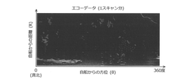
- the echo data provided from the radar 2 to the data acquisition device 1 has amplitude data in the R ⁇ coordinates represented by the orientation ( ⁇ ) and the distance (R) with respect to the own ship, as shown in FIG. 2, for example.
- the associated R- ⁇ data (so-called raw data). Instead of the amplitude data, phase data may be associated with it. Echo data for one scan is generated for each rotation of the antenna.
- the direction ( ⁇ ) of the echo data is expressed from 0 to 360 degrees with true north as 0 degrees.
- the direction ( ⁇ ) is the direction detected by the direction sensor 5. That is, the echo data is associated with the direction detected by the direction sensor 5.
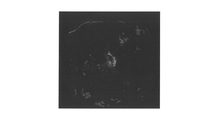
- the echo data may be display data (so-called PPI display data) after signal processing in which R- ⁇ data is converted into a circle centered on the ship, as shown in FIG. 3, for example. ..
- AIS3 receives AIS data from other vessels or land controls existing around its own vessel.
- AIS3 is an example of a communication device
- AIS data is an example of navigation data of another ship.
- the AIS data includes data such as the position of another ship, the bow bearing, the direction of the ship, the speed of the ship, the length of the hull, and the identification code (MMSI).
- MMSI identification code
- the position data of other ships is represented by the absolute position (latitude / longitude).
- VDES VHFDataExchangeSystem
- VHFDataExchangeSystem may be used instead of AIS.
- the GNSS receiver 4 generates position data of its own ship based on the radio waves received from the GNSS (Global Navigation Satellite System).
- the GNSS receiver 4 is an example of a positioning device.
- the position data of the own ship is represented by the absolute position (latitude / longitude).
- the directional sensor 5 detects the directional of the own ship. Like the radar 2, the directional sensor 5 is installed so that its reference directional matches the bow directional.
- the azimuth sensor 5 is, for example, a GPS compass, a magnetic compass, or a gyro compass.
- the data collection device 1 includes a partial extraction unit 11, an estimation unit 12, a suitability determination unit 13, a storage processing unit 14, a transfer processing unit 15, and a model updating unit 16. These functional units are realized by the CPU of the data acquisition device 1 executing information processing according to a program.
- the data collection device 1 further includes a buffer memory 21, a storage database 22, and a model storage unit 23. These storage units are provided in the non-volatile memory of the data acquisition device 1. A part of the functional unit or the storage unit may be provided outside the data acquisition device 1.
- FIG. 4 is a diagram showing a procedure example of a learning data collection method according to an embodiment realized in the learning data collection system 100.
- the CPU of the data acquisition device 1 executes the information processing shown in the figure according to the program.
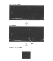
- FIG. 5 is a diagram for explaining the extraction of partial echo data.
- the data collecting device 1 acquires AIS data from AIS3 and acquires echo data from radar 2 (S11, S12: processing as an acquisition unit).
- the data collecting device 1 identifies a region corresponding to the position data of the other ship in the AIS data in the echo data based on the position data of the own ship and the position data of the other ship, and also specifies from the echo data.
- Partial echo data of the removed area is extracted (S13, S14: processing as the partial extraction unit 11, see FIG. 5).
- the echo data in which the directions are associated is calculated.
- the position within is specified.
- the area is, for example, a rectangular area centered on a point represented by the position data of another ship.
- the extracted partial echo data is stored in the buffer memory 21.
- the data acquisition device 1 extracts partial echo data from the echo data each time the radar 2 generates echo data for one scan. Therefore, the buffer memory 21 stores partial echo data for a plurality of scans for one AIS data.
- the data acquisition device 1 uses the trained model stored in the model storage unit 23 to use the partial echo data for k scans.
- the accuracy of the target is estimated from the above, and it is determined whether or not the accuracy is equal to or higher than the threshold value (S16, S17: processing as the estimation unit 12 and the suitability determination unit 13). By this process, it is determined whether or not the partial echo data is suitable as learning data.
- k is a natural number.
- the trained model is a model generated in advance by machine learning using echo data as input data and the presence or absence of a target as teacher data.
- the trained model is, for example, a detection / identification model such as SSD (Single Shot MultiBox Detector), YOLO (You Only Look Once), or Faster R-CNN. Not limited to this, a discriminative model that only discriminates a target may be used.
- the trained model is configured to output the accuracy of the identified target by a softmax function provided in the output layer.
- the data collection device 1 acquires partial echo data for k scans for which the accuracy of the target is determined to be equal to or higher than the threshold value from the buffer memory 21, associates it with AIS data and radar-related data, and stores it in the storage DB 22.
- S18 Processing as the storage processing unit 14).
- the storage processing unit 14 is an example of an association unit.
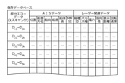
- FIG. 6 is a diagram showing an example of the storage DB 22.
- AIS data and radar-related data are associated with the partial echo data.
- the AIS data includes data such as the position of another ship, the direction of the bow, the direction of the ship, the speed of the ship, the length of the hull, and the identification code.
- Radar-related data includes data such as radar model, pulse width, power, directivity, display distance, and rotation speed. It should be noted that k in each row of the partial echo data may be a different natural number. Further, the data such as the position of another ship stored in the storage DB 22 is not limited to absolute information, but may be relative information to the own ship.
- the partial echo data of the region corresponding to the position data of the AIS data is extracted from the echo data, it becomes easy to collect the learning data. In particular, it is possible to collect useful learning data and reduce the amount of data. Further, since the partial echo data is stored in association with the AIS data and the radar-related data, it becomes easier to collect the learning data.
- the shape or size of the region extracted in S12 and S13 may be changed according to the AIS data or the radar-related data.
- the area may be extended to the bow direction or the direction included in the AIS data, or the area may be increased as the ship speed, turning speed, or hull length increases.
- the region may be extended in the ⁇ direction as the directivity (antenna width) included in the radar-related data or the rotation speed of the antenna increases.
- FIG. 7 is a diagram showing an example of a procedure for communication with the ground DB 8 and the learning device 9.
- the CPU of the data acquisition device 1 executes the information processing shown in the figure according to the program.
- the data collecting device 1 can communicate with the terrestrial DB 8 by wire or wirelessly (S21: YES), the partial echo data stored in the storage DB 22 and the AIS data and radar-related data associated with the partial echo data (see FIG. 6). ) Is transferred to the ground DB 8 (S22: processing as the transfer processing unit 15), and the partially echo data and the like for which the transfer is completed are deleted from the storage DB 22 to make a space (S23).
- the data acquisition device 1 acquires the new version of the trained model from the learning device 9 and stores the model. Store in 23. (S25: Processing as the model update unit 16). Specifically, the trained model stored in the model storage unit 23 is replaced with a new version of the trained model.
- the partial echo data and the like are transferred when the ship returns to the port and communication with the ground DB 8 is established, so that the learning data can be easily taken out.
- the amount of data is reduced by extracting the partial echo data, it is possible to quickly retrieve the learning data.
- the learning device 9 relearns using the useful learning data stored in the ground DB 8 to update the trained model, and the data collection device 1 uses the updated trained model for more useful learning. By repeating the cycle of collecting data, it is possible to continuously improve the trained model.
- a trained model may be generated for each radar model by using the radar model included in the radar-related data.
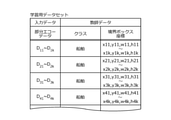
- FIG. 8 is a diagram showing an example of a training data set used in the training phase to generate a trained model.
- the training data set contains input data and teacher data.
- the input data is partial echo data collected by the data collecting device 1 and transferred to the ground DB 8.
- the input data is not limited to partial echo data, and may include ordinary echo data.
- the teacher data is the coordinates of the boundary box including the target class and the target appearing in the partial echo data.
- the input data is partial echo data obtained by extracting the area corresponding to the position data of the AIS data from the echo data
- the coordinates of the boundary box may be the entire partial echo data, so that the coordinates of the boundary box can be easily set. be.
- the target class is a ship. Not limited to this, using the identification code of the AIS data associated with the partial echo data, the class of the target can be classified according to the size of the vessel such as a small vessel, a medium-sized vessel, a large vessel, or a super-large vessel. It may be divided into types related to the type of ship such as a pleasure ship, a fishing ship, a commercial ship, or a tanker ship.
- FIG. 9 is a diagram for explaining the learning phase.
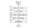
- FIG. 10 is a diagram showing a procedure example of the learning phase.
- the CPU of the learning device 9 executes the information processing shown in the figure according to the program.
- a detection / identification model such as SSD (Single Shot MultiBox Detector) is used.
- the output layer of the detection / identification model is provided with elements of class (Class name), coordinates of the boundary box (Bounding Box (x, y, w, h)), and accuracy (Confidence).
- a softmax function is used as an element of accuracy.
- the learning device 9 inputs the partial echo data included in the training data set as input data into the detection / identification model (S31), performs calculations by the detection / identification model (S32), and coordinates the class and the boundary box. , And the accuracy are output as output data (S33).
- the learning device 9 calculates the difference between the coordinates of the class and the boundary box as the teacher data included in the training data set and the coordinates of the class and the boundary box as the output data (S34), and back-propagates the error. Perform the calculation (S35).
- the learning data set may be modified as follows.
- FIG. 11 is a diagram showing another example of the training data set.
- the input data of the training data set further includes AIS data and radar-related data associated with the partial echo data by the data acquisition device 1.
- the detection / identification model of this example is configured to estimate the target class, boundary box coordinates, and accuracy using not only partial echo data but also AIS data and radar-related data. This makes it possible to further improve the estimation accuracy.
- FIG. 12 is a diagram showing still another example of the training data set.
- the teacher data in the training dataset further includes AIS data associated with the partial echo data by the data acquisition device 1.
- the teacher data includes some data of the AIS data, such as data such as bow bearing, ship direction, ship speed, hull length, and identification code.
- the detection / identification model of this example is configured to estimate not only the class, the coordinates of the boundary box, and the accuracy, but also the AIS data corresponding to the teacher data.
- 1 data collection device 2 radar, 3 AIS, 4 GNSS receiver, 5 orientation sensor, 11 partial extraction unit, 12 estimation unit, 13 suitability judgment unit, 14 storage processing unit, 15 transfer processing unit, 16 model update unit, 21 Buffer memory, 22 storage database, 23 model storage, 8 ground database, 9 learning device, 100 learning data collection system, 200 learning system
Landscapes
- Engineering & Computer Science (AREA)
- Remote Sensing (AREA)
- Radar, Positioning & Navigation (AREA)
- Physics & Mathematics (AREA)
- General Physics & Mathematics (AREA)
- Theoretical Computer Science (AREA)
- Computer Networks & Wireless Communication (AREA)
- Software Systems (AREA)
- Evolutionary Computation (AREA)
- Artificial Intelligence (AREA)
- Computer Vision & Pattern Recognition (AREA)
- Mathematical Physics (AREA)
- Medical Informatics (AREA)
- Data Mining & Analysis (AREA)
- General Engineering & Computer Science (AREA)
- Computing Systems (AREA)
- Ocean & Marine Engineering (AREA)
- Electromagnetism (AREA)
- Radar Systems Or Details Thereof (AREA)
- Traffic Control Systems (AREA)
Abstract
【課題】学習用データの収集が容易な学習用データ収集システムを提供する。 【解決手段】学習用データ収集システムは、船舶の周囲に発せられた電波の反射波を受信して、方位が対応付けられたエコーデータを生成するレーダーと、他船の位置データを含む他船航行データを受信する通信装置と、エコーデータから、位置データに対応する領域の部分エコーデータを抽出する部分抽出部とを備える。
Description
本発明は、学習用データ収集システム、学習用データ収集方法、データ収集装置、プログラム、学習済みモデルの生成方法、学習装置、及び推定装置に関する。
特許文献1には、SAR画像から船舶候補領域画像を抽出し、船舶候補領域画像を二値化処理した二値化画像を生成し、当該二値化画像と船舶候補領域画像とを合成することにより評価画像を生成し、評価画像に基づいて船舶検出結果を精査することが開示されている。
ところで、レーダーにより生成されるエコーデータから物標を検出・識別するAIシステムを実現するには、多数の学習用データが必要であるが、手作業によりアノテーションを行うことは困難を伴う。
本発明は、上記課題に鑑みてなされたものであり、その主な目的は、学習用データの収集が容易な学習用データ収集システム、学習用データ収集方法、データ収集装置、プログラム、学習済みモデルの生成方法、学習装置、及び推定装置を提供することにある。
上記課題を解決するため、本発明の一の態様の学習用データ収集システムは、船舶の位置データを生成する測位装置と、前記船舶の周囲に発せられた電波の反射波を受信して、方位が対応付けられたエコーデータを生成するレーダーと、他船の位置データを含む他船航行データを受信する通信装置と、前記船舶の位置データ及び前記他船の位置データに基づいて、前記エコーデータから、前記他船の位置データに対応する領域の部分エコーデータを抽出する部分抽出部と、を備える。
また、本発明の他の態様の学習用データ収集方法は、測位装置により、船舶の位置データを生成し、レーダーにより、前記船舶の周囲に発せられた電波の反射波を受信して、方位が対応付けられたエコーデータを生成し、通信装置により、他船の位置データを含む他船航行データを受信し、前記船舶の位置データ及び前記他船の位置データに基づいて、前記エコーデータから、前記他船の位置データに対応する領域の部分エコーデータを抽出する。
また、本発明の他の態様のデータ収集装置は、船舶の位置データを生成する測位装置から前記船舶の位置データを取得する取得部と、前記船舶の周囲に発せられた電波の反射波を受信して、方位が対応付けられたエコーデータを生成するレーダーから前記エコーデータを取得する取得部と、他船の位置データを含む他船航行データを受信する通信装置から前記他船航行データを取得する取得部と、前記船舶の位置データ及び前記他船の位置データに基づいて、前記エコーデータから、前記他船の位置データに対応する領域の部分エコーデータを抽出する部分抽出部と、を備える。
また、本発明の他の態様のプログラムは、船舶の位置データを生成する測位装置から前記船舶の位置データを取得すること、前記船舶の周囲に発せられた電波の反射波を受信して、方位が対応付けられたエコーデータを生成するレーダーから前記エコーデータを取得すること、他船の位置データを含む他船航行データを受信する通信装置から前記他船航行データを取得すること、前記船舶の位置データ及び前記他船の位置データに基づいて、前記エコーデータから、前記他船の位置データに対応する領域の部分エコーデータを抽出すること、をコンピュータに実行させる。
また、本発明の他の態様の学習済みモデルの生成方法は、測位装置により、船舶の位置データを生成し、レーダーにより、前記船舶の周囲に発せられた電波の反射波を受信して、方位が対応付けられたエコーデータを生成し、通信装置により、他船の位置データを含む他船航行データを受信し、前記船舶の位置データ及び前記他船の位置データに基づいて、前記エコーデータから、前記他船の位置データに対応する領域の部分エコーデータを抽出し、前記部分エコーデータを入力データとし、物標の有無を教師データとして、エコーデータから物標の確度を推定するための学習済みモデルを機械学習により生成する。
また、本発明の他の態様の学習装置は、船舶の周囲に発せられた電波の反射波を受信するレーダーにより生成されたエコーデータと、通信装置により受信された他船航行データとを含むデータセットを取得する取得部と、前記エコーデータを入力データとし、前記他船航行データを教師データとして、エコーデータから他船航行データを推定するための学習済みモデルを機械学習により生成する学習部と、を備える。
また、本発明の他の態様の学習済みモデルの生成方法は、船舶の周囲に発せられた電波の反射波を受信するレーダーにより生成されたエコーデータと、通信装置により受信された他船航行データとを含むデータセットを取得し、前記エコーデータを入力データとし、前記他船航行データを教師データとして、エコーデータから他船航行データを推定するための学習済みモデルを機械学習により生成する。
また、本発明の他の態様の推定装置は、船舶の周囲に発せられた電波の反射波を受信するレーダーにより生成されたエコーデータを取得する取得部と、エコーデータを入力データとし、他船航行データを教師データとして機械学習により予め生成された学習済みモデルを用い、前記取得されたエコーデータから他船航行データを推定する推定部と、を備える。
また、本発明の他の態様のプログラムは、船舶の周囲に発せられた電波の反射波を受信するレーダーにより生成されたエコーデータを取得すること、エコーデータを入力データとし、他船航行データを教師データとして機械学習により予め生成された学習済みモデルを用い、前記取得されたエコーデータから他船航行データを推定すること、をコンピュータに実行させる。
本発明によれば、学習用データの収集が容易となる。
以下、本発明の実施形態について、図面を参照しながら説明する。
[システム概要]
図1は、実施形態に係る学習用データ収集システム100の構成例を示す図である。学習用データ収集システム100は、レーダーエコーから物標を検出・識別するための検出・識別モデルの学習に用いられる学習用データを収集するためのシステムである。
図1は、実施形態に係る学習用データ収集システム100の構成例を示す図である。学習用データ収集システム100は、レーダーエコーから物標を検出・識別するための検出・識別モデルの学習に用いられる学習用データを収集するためのシステムである。
学習用データ収集システム100は、船舶に搭載され、船舶の出港から帰港までの期間に学習用データを収集する。また、学習用データ収集システム100は、船舶が帰港すると、収集した学習用データを地上のデータベース(地上DB)8に転送する。
学習装置9は、地上DB8に記憶された学習用データを用いて検出・識別モデルの学習を行う。なお、学習用データ収集システム100、地上DB8、及び学習装置9を含めて、学習システム200と呼ぶ。地上DB8及び学習装置9は、外部装置の例である。
学習用データ収集システム100は、データ収集装置1、レーダー2、AIS(Automatic Identification System)3、GNSS受信機4、及び方位センサ5を備えている。
データ収集装置1は、CPU、RAM、ROM、不揮発性メモリ、及び入出力インターフェース等を含むコンピュータである。データ収集装置1のCPUは、ROM又は不揮発性メモリからRAMにロードされたプログラムに従って情報処理を実行する。
プログラムは、例えば光ディスク又はメモリカード等の情報記憶媒体を介して供給されてもよいし、例えばインターネット又はLAN等の通信ネットワークを介して供給されてもよい。
レーダー2は、アンテナにより自船の周囲に電波を発するとともにその反射波を受信し、受信信号に基づいてエコーデータを生成する。レーダー2は、その基準方位が船首方位と合致するように設置される。
レーダー2からデータ収集装置1に提供されるエコーデータは、例えば図2に示すような、自船を基準とする方位(θ)と距離(R)で表されるR-θ座標に振幅データを対応付けたR-θデータ(いわゆる生データ)である。振幅データに代えて、位相データが対応付けられてもよい。アンテナが1回転する毎に1スキャン分のエコーデータが生成される。
エコーデータの方位(θ)は、真北を0度として0~360度で表される。方位(θ)は、方位センサ5により検出された方位である。すなわち、エコーデータには、方位センサ5により検出された方位が対応付けられる。
これに限らず、エコーデータは、例えば図3に示すような、R-θデータを自船を中心とする円形に変換した信号処理後の表示用データ(いわゆるPPI表示データ)であってもよい。
AIS3は、自船の周囲に存在する他船又は陸上の管制からAISデータを受信する。AIS3は通信装置の例であり、AISデータは他船航行データの例である。AISデータは、例えば他船の位置、船首方位、船向、船速、船体長、及び識別符号(MMSI)等のデータを含んでいる。他船の位置データは、絶対位置(緯度・経度)で表される。AISに代えて、VDES(VHF Data Exchange System)が用いられてもよい。
GNSS受信機4は、GNSS(Global Navigation Satellite System)から受信した電波に基づいて自船の位置データを生成する。GNSS受信機4は、測位装置の例である。自船の位置データは、絶対位置(緯度・経度)で表される。
方位センサ5は、自船の方位を検出する。方位センサ5は、レーダー2と同様に、その基準方位が船首方位と合致するように設置される。方位センサ5は、例えばGPSコンパス、磁気コンパス、又はジャイロコンパスである。
データ収集装置1は、部分抽出部11、推定部12、適否判定部13、保存処理部14、転送処理部15、及びモデル更新部16を備えている。これらの機能部は、データ収集装置1のCPUがプログラムに従って情報処理を実行することによって実現される。
データ収集装置1は、バッファメモリ21、保存データベース22、及びモデル記憶部23をさらに備えている。これらの記憶部は、データ収集装置1の不揮発性メモリに設けられる。機能部又は記憶部の一部は、データ収集装置1の外部に設けられてもよい。
[学習データの収集]
図4は、学習用データ収集システム100において実現される、実施形態に係る学習用データ収集方法の手順例を示す図である。データ収集装置1のCPUは、同図に示す情報処理をプログラムに従って実行する。図5は、部分エコーデータの抽出を説明するための図である。
図4は、学習用データ収集システム100において実現される、実施形態に係る学習用データ収集方法の手順例を示す図である。データ収集装置1のCPUは、同図に示す情報処理をプログラムに従って実行する。図5は、部分エコーデータの抽出を説明するための図である。
まず、データ収集装置1は、AIS3からAISデータを取得し、レーダー2からエコーデータを取得する(S11,S12:取得部としての処理)。
次に、データ収集装置1は、自船の位置データ及び他船の位置データに基づいて、エコーデータにおいて、AISデータの他船の位置データに対応する領域を特定するとともに、エコーデータから、特定した領域の部分エコーデータを抽出する(S13,S14:部分抽出部11としての処理、図5参照)。ここでは、自船及び他船の絶対位置(緯度・経度)から、自船を基準とする他船の距離(R)と方位(θ)を算出することで、方位が対応付けられたエコーデータ内の位置を特定している。領域は、例えば他船の位置データが表す地点を中心に含む矩形の領域である。抽出された部分エコーデータは、バッファメモリ21に記憶される。
データ収集装置1は、レーダー2が1スキャン分のエコーデータを生成する毎に、エコーデータから部分エコーデータを抽出する。このため、バッファメモリ21には、1つのAISデータについて複数スキャン分の部分エコーデータが蓄積される。
バッファメモリ21にkスキャン分の部分エコーデータが蓄積されると(S15:YES)、データ収集装置1は、モデル記憶部23に記憶された学習済みモデルを用いて、kスキャン分の部分エコーデータから物標の確度を推定し、確度が閾値以上か否か判定する(S16,S17:推定部12及び適否判定部13としての処理)。この処理により、部分エコーデータが学習用データとして適しているか否かが判定される。なお、kは自然数である。
学習済みモデルは、エコーデータを入力データとし、物標の有無を教師データとして機械学習により予め生成されたモデルである。学習済みモデルは、例えばSSD(Single Shot MultiBox Detector)、YOLO(You Only Look Once)、又はFaster R-CNN等の検出・識別モデルである。これに限らず、物標の識別のみを行う識別モデルが用いられてもよい。学習済みモデルは、出力層に設けられたソフトマックス関数により、識別した物標の確度を出力するように構成される。
次に、データ収集装置1は、物標の確度が閾値以上と判定されたkスキャン分の部分エコーデータをバッファメモリ21から取得し、AISデータ及びレーダー関連データと関連付けて、保存DB22に保存する(S18:保存処理部14としての処理)。保存処理部14は、関連付け部の例である。
図6は、保存DB22の例を示す図である。保存DB22では、部分エコーデータにAISデータ及びレーダー関連データが関連付けられている。AISデータは、例えば他船の位置、船首方位、船向、船速、船体長、及び識別符号などのデータを含んでいる。レーダー関連データは、例えばレーダーの機種、パルス幅、電力、指向性、表示距離、及び回転速度などのデータを含んでいる。なお、部分エコーデータの各行のkは、それぞれ異なる自然数であってもよい。また、保存DB22に保存される他船の位置等のデータは、絶対情報に限らず、自船に対する相対情報であってもよい。
以上により、学習用データ収集方法の手順が終了する。
本実施形態によれば、エコーデータから、AISデータの位置データに対応する領域の部分エコーデータが抽出されるので、学習用データの収集が容易となる。特には、有用な学習用データの収集及びデータ量の低減が可能である。また、部分エコーデータはAISデータ及びレーダー関連データと関連付けて保存されるので、学習用データの収集がさらに容易となる。
また、学習用データとして適した、物標の確度が閾値以上の部分エコーデータが保存されるので、より有用な学習用データの収集が可能となる。また、1つのAISデータについて得られたkスキャン分の部分エコーデータから物標の確度を推定するので、推定精度の向上を図ることが可能である。
なお、上記S12,S13において抽出される領域の形状又は大きさは、AISデータ又はレーダー関連データに応じて変更されてもよい。例えば、AISデータに含まれる船首方位又は船向に領域を伸ばしてもよいし、船速、回頭速度、又は船体長が大きいほど領域を大きくしてもよい。また、レーダー関連データに含まれる指向性(アンテナ幅)又はアンテナの回転速度が高いほどθ方向に領域を伸ばしてもよい。
[地上装置との通信]
以下、学習用データ収集システム100を搭載した船舶が帰港したときに行われる、地上に設けられた地上DB8及び学習装置9との通信について説明する。図7は、地上DB8及び学習装置9との通信の手順例を示す図である。データ収集装置1のCPUは、同図に示す情報処理をプログラムに従って実行する。
以下、学習用データ収集システム100を搭載した船舶が帰港したときに行われる、地上に設けられた地上DB8及び学習装置9との通信について説明する。図7は、地上DB8及び学習装置9との通信の手順例を示す図である。データ収集装置1のCPUは、同図に示す情報処理をプログラムに従って実行する。
まず、データ収集装置1は、地上DB8と有線又は無線による通信が可能になると(S21:YES)、保存DB22に蓄積された部分エコーデータ及びそれに関連付けられたAISデータ及びレーダー関連データ(図6参照)を、地上DB8に転送するとともに(S22:転送処理部15としての処理)、転送が完了した部分エコーデータ等を保存DB22から削除し、空きを作る(S23)。
次に、データ収集装置1は、学習装置9により生成された新バージョンの学習済みモデルがある場合には(S24:YES)、学習装置9から新バージョンの学習済みモデルを取得し、モデル記憶部23に記憶する。(S25:モデル更新部16としての処理)。具体的には、モデル記憶部23に記憶された学習済みモデルを、新バージョンの学習済みモデルと置き換える。
以上により、地上DB8及び学習装置9との通信の手順が終了する。
本実施形態によれば、船舶が帰港して地上DB8との通信が確立したときに部分エコーデータ等の転送が行われるので、学習用データの取出しが容易となる。特に、本実施形態では、部分エコーデータを抽出することでデータ量が低減されているので、学習用データの迅速な取出しが可能である。
また、地上DB8に記憶された有用な学習用データを用いて学習装置9が再学習を行って学習済みモデルを更新し、データ収集装置1が更新された学習済みモデルを用いてさらに有用な学習用データを収集するサイクルを繰り返すことにより、学習済みモデルの継続的な改善が可能となる。
また、複数の船舶により並列して収集された学習用データを用いて学習済みモデルを更新することで、より効率的な学習済みモデルの改善が可能となる。また、レーダー関連データに含まれるレーダーの機種を利用して、レーダーの機種毎に学習済みモデルを生成してもよい。
[学習フェーズ]
以下、学習システム200の学習装置9において実現される、実施形態に係る学習済みモデルの生成方法について説明する。図8は、学習済みモデルを生成する学習フェーズに用いられる学習用データセットの例を示す図である。学習用データセットは、入力データ及び教師データを含んでいる。
以下、学習システム200の学習装置9において実現される、実施形態に係る学習済みモデルの生成方法について説明する。図8は、学習済みモデルを生成する学習フェーズに用いられる学習用データセットの例を示す図である。学習用データセットは、入力データ及び教師データを含んでいる。
入力データは、上記データ収集装置1により収集され、地上DB8に転送された部分エコーデータである。入力データは、部分エコーデータに限らず、通常のエコーデータを含んでもよい。
教師データは、部分エコーデータに表れる物標のクラス及び物標を含む境界ボックスの座標である。入力データが、エコーデータからAISデータの位置データに対応する領域を抽出した部分エコーデータである場合、境界ボックスの座標を部分エコーデータ全体とすれば良いので、境界ボックスの座標の設定が容易である。
物標のクラスは、船舶である。これに限らず、部分エコーデータに関連付けられたAISデータの識別符号を利用して、物標のクラスを、例えば小型船、中型船、大型船、又は超大型船などの船舶の大きさに関する種別に分けてよいし、例えばプレジャー船、漁船、商船、又はタンカー船などの船舶の種類に関する種別に分けてもよい。
図9は、学習フェーズを説明するための図である。図10は、学習フェーズの手順例を示す図である。学習装置9のCPUは、同図に示す情報処理をプログラムに従って実行する。
本実施形態では、例えばSSD(Single Shot MultiBox Detector)等の検出・識別モデルが用いられる。検出・識別モデルの出力層には、クラス(Class name)、境界ボックスの座標(Bounding Box (x,y,w,h))、及び確度(Confidence)の要素が設けられる。確度の要素には、ソフトマックス関数が用いられる。
まず、学習装置9は、学習用データセットに含まれる部分エコーデータを入力データとして検出・識別モデルに入力し(S31)、検出・識別モデルによる計算を行い(S32)、クラス、境界ボックスの座標、及び確度を出力データとして出力する(S33)。
次に、学習装置9は、学習用データセットに含まれる教師データとしてのクラス及び境界ボックスの座標と、出力データとしてのクラス及び境界ボックスの座標との差分を算出し(S34)、誤差逆伝播計算を行う(S35)。
これにより、エコーデータから物標のクラス、境界ボックスの座標、及び確度を推定するための学習済みの検出・識別モデルが生成される。
なお、学習用データセットは、以下のように変形してもよい。
図11は、学習用データセットの他の例を示す図である。本例では、学習用データセットの入力データが、上記データ収集装置1により部分エコーデータと関連付けられたAISデータ及びレーダー関連データをさらに含んでいる。
このため、本例の検出・識別モデルは、部分エコーデータだけでなくAISデータ及びレーダー関連データも利用して、物標のクラス、境界ボックスの座標、及び確度を推定するように構成される。これにより、推定精度のさらなる向上を図ることが可能である。
図12は、学習用データセットのさらに他の例を示す図である。本例では、学習用データセットの教師データが、上記データ収集装置1により部分エコーデータと関連付けられたAISデータをさらに含んでいる。具体的には、教師データは、AISデータの一部のデータ、例えば船首方位、船向、船速、船体長、及び識別符号等のデータを含んでいる。
このため、本例の検出・識別モデルは、クラス、境界ボックスの座標、及び確度だけでなく、教師データに対応するAISデータも推定するように構成される。
これにより、AISデータを送信しない他船についてエコーデータからAISデータを知得することが可能となる。また、自船がAIS非搭載である場合に、エコーデータからAISデータを知得することも可能となる。
以上、本発明の実施形態について説明したが、本発明は以上に説明した実施形態に限定されるものではなく、種々の変更が当業者にとって可能であることはもちろんである。
1 データ収集装置、2 レーダー、3 AIS、4 GNSS受信機、5 方位センサ、11 部分抽出部、12 推定部、13 適否判定部、14 保存処理部、15 転送処理部、16 モデル更新部、21 バッファメモリ、22 保存データベース、23 モデル記憶部、8 地上データベース、9 学習装置、100 学習用データ収集システム、200 学習システム
Claims (18)
- 船舶の位置データを生成する測位装置と、
前記船舶の周囲に発せられた電波の反射波を受信して、方位が対応付けられたエコーデータを生成するレーダーと、
他船の位置データを含む他船航行データを受信する通信装置と、
前記船舶の位置データ及び前記他船の位置データに基づいて、前記エコーデータから、前記他船の位置データに対応する領域の部分エコーデータを抽出する部分抽出部と、
を備える、学習用データ収集システム。 - 前記部分エコーデータに前記他船航行データを関連付ける関連付け部をさらに備える、
請求項1に記載の学習用データ収集システム。 - 前記部分エコーデータに前記レーダーに関するレーダー関連データを関連付ける関連付け部をさらに備える、
請求項1または2に記載の学習用データ収集システム。 - 前記部分エコーデータの学習用データとしての適否を判定する適否判定部をさらに備える、
請求項1ないし3の何れかに記載の学習用データ収集システム。 - 前記適否判定部は、エコーデータを入力データとし、物標の有無を教師データとして機械学習により予め生成された学習済みモデルを用いて、前記部分エコーデータから物標の確度を推定し、前記確度に応じて前記部分エコーデータの適否を判定する、
請求項4に記載の学習用データ収集システム。 - 前記適否判定部は、1つの前記他船航行データについて得られた時系列の複数の前記部分エコーデータから物標の確度を推定する、
請求項5に記載の学習用データ収集システム。 - 外部装置との通信が可能である場合に、記憶部に蓄積された前記部分エコーデータを前記外部装置に転送する転送処理部をさらに備える、
請求項1ないし6の何れかに記載の学習用データ収集システム。 - 外部装置との通信が可能である場合に、記憶部に記憶された前記学習済みモデルを前記外部装置から提供された学習済みモデルと置き換えるモデル更新部をさらに備える、
請求項5または6に記載の学習用データ収集システム。 - 前記部分抽出部は、前記他船航行データ又はレーダー関連データに応じて前記領域の形状又は大きさを変更する、
請求項1ないし8の何れかに記載の学習用データ収集システム。 - 前記船舶の方位を検出する方位センサをさらに備え、
前記レーダーは、前記方位センサにより検出される方位を前記エコーデータに対応付ける、
請求項1ないし9の何れかに記載の学習用データ収集システム。 - 測位装置により、船舶の位置データを生成し、
レーダーにより、前記船舶の周囲に発せられた電波の反射波を受信して、方位が対応付けられたエコーデータを生成し、
通信装置により、他船の位置データを含む他船航行データを受信し、
前記船舶の位置データ及び前記他船の位置データに基づいて、前記エコーデータから、前記他船の位置データに対応する領域の部分エコーデータを抽出する、
学習用データ収集方法。 - 船舶の位置データを生成する測位装置から前記船舶の位置データを取得する取得部と、
前記船舶の周囲に発せられた電波の反射波を受信して、方位が対応付けられたエコーデータを生成するレーダーから前記エコーデータを取得する取得部と、
他船の位置データを含む他船航行データを受信する通信装置から前記他船航行データを取得する取得部と、
前記船舶の位置データ及び前記他船の位置データに基づいて、前記エコーデータから、前記他船の位置データに対応する領域の部分エコーデータを抽出する部分抽出部と、
を備える、データ収集装置。 - 船舶の位置データを生成する測位装置から前記船舶の位置データを取得すること、
前記船舶の周囲に発せられた電波の反射波を受信して、方位が対応付けられたエコーデータを生成するレーダーから前記エコーデータを取得すること、
他船の位置データを含む他船航行データを受信する通信装置から前記他船航行データを取得すること、
前記船舶の位置データ及び前記他船の位置データに基づいて、前記エコーデータから、前記他船の位置データに対応する領域の部分エコーデータを抽出すること、
をコンピュータに実行させるプログラム。 - 測位装置により、船舶の位置データを生成し、
レーダーにより、前記船舶の周囲に発せられた電波の反射波を受信して、方位が対応付けられたエコーデータを生成し、
通信装置により、他船の位置データを含む他船航行データを受信し、
前記船舶の位置データ及び前記他船の位置データに基づいて、前記エコーデータから、前記他船の位置データに対応する領域の部分エコーデータを抽出し、
前記部分エコーデータを入力データとし、物標の有無を教師データとして、エコーデータから物標の確度を推定するための学習済みモデルを機械学習により生成する、
学習済みモデルの生成方法。 - 船舶の周囲に発せられた電波の反射波を受信するレーダーにより生成されたエコーデータと、通信装置により受信された他船航行データとを含むデータセットを取得する取得部と、
前記エコーデータを入力データとし、前記他船航行データを教師データとして、エコーデータから他船航行データを推定するための学習済みモデルを機械学習により生成する学習部と、
を備える学習装置。 - 船舶の周囲に発せられた電波の反射波を受信するレーダーにより生成されたエコーデータと、通信装置により受信された他船航行データとを含むデータセットを取得し、
前記エコーデータを入力データとし、前記他船航行データを教師データとして、エコーデータから他船航行データを推定するための学習済みモデルを機械学習により生成する、
学習済みモデルの生成方法。 - 船舶の周囲に発せられた電波の反射波を受信するレーダーにより生成されたエコーデータを取得する取得部と、
エコーデータを入力データとし、他船航行データを教師データとして機械学習により予め生成された学習済みモデルを用い、前記取得されたエコーデータから他船航行データを推定する推定部と、
を備える推定装置。 - 船舶の周囲に発せられた電波の反射波を受信するレーダーにより生成されたエコーデータを取得すること、
エコーデータを入力データとし、他船航行データを教師データとして機械学習により予め生成された学習済みモデルを用い、前記取得されたエコーデータから他船航行データを推定すること、
をコンピュータに実行させるプログラム。
Priority Applications (2)
| Application Number | Priority Date | Filing Date | Title |
|---|---|---|---|
| JP2022536176A JP7781752B2 (ja) | 2020-07-13 | 2021-06-11 | 学習用データ収集システム、学習用データ収集方法、データ収集装置、プログラム、学習済みモデルの生成方法、学習装置、及び推定装置 |
| US18/153,976 US20230169404A1 (en) | 2020-07-13 | 2023-01-12 | Learning data collecting system, method of collecting learning data, and estimating device |
Applications Claiming Priority (2)
| Application Number | Priority Date | Filing Date | Title |
|---|---|---|---|
| JP2020-119810 | 2020-07-13 | ||
| JP2020119810 | 2020-07-13 |
Related Child Applications (1)
| Application Number | Title | Priority Date | Filing Date |
|---|---|---|---|
| US18/153,976 Continuation-In-Part US20230169404A1 (en) | 2020-07-13 | 2023-01-12 | Learning data collecting system, method of collecting learning data, and estimating device |
Publications (1)
| Publication Number | Publication Date |
|---|---|
| WO2022014220A1 true WO2022014220A1 (ja) | 2022-01-20 |
Family
ID=79555425
Family Applications (1)
| Application Number | Title | Priority Date | Filing Date |
|---|---|---|---|
| PCT/JP2021/022279 Ceased WO2022014220A1 (ja) | 2020-07-13 | 2021-06-11 | 学習用データ収集システム、学習用データ収集方法、データ収集装置、プログラム、学習済みモデルの生成方法、学習装置、及び推定装置 |
Country Status (3)
| Country | Link |
|---|---|
| US (1) | US20230169404A1 (ja) |
| JP (1) | JP7781752B2 (ja) |
| WO (1) | WO2022014220A1 (ja) |
Cited By (1)
| Publication number | Priority date | Publication date | Assignee | Title |
|---|---|---|---|---|
| WO2023162562A1 (ja) * | 2022-02-25 | 2023-08-31 | 古野電気株式会社 | 物標監視システム、物標監視方法、及びプログラム |
Citations (5)
| Publication number | Priority date | Publication date | Assignee | Title |
|---|---|---|---|---|
| JP2010181985A (ja) * | 2009-02-04 | 2010-08-19 | Japan Radio Co Ltd | 船舶搭載用航行支援システム |
| JP2011099836A (ja) * | 2009-11-09 | 2011-05-19 | Furuno Electric Co Ltd | 信号処理装置、レーダ装置及び信号処理プログラム |
| JP2012128558A (ja) * | 2010-12-14 | 2012-07-05 | Toshiba Corp | 識別装置 |
| WO2020049634A1 (ja) * | 2018-09-04 | 2020-03-12 | 三菱電機株式会社 | 教師データ生成装置、教師データ生成方法、および、教師データ生成システム |
| US20200202147A1 (en) * | 2018-12-21 | 2020-06-25 | Continental Automotive Systems Inc. | Systems and methods for automatic labeling of images for supervised machine learning |
Family Cites Families (1)
| Publication number | Priority date | Publication date | Assignee | Title |
|---|---|---|---|---|
| JP7122625B2 (ja) | 2018-07-02 | 2022-08-22 | パナソニックIpマネジメント株式会社 | 学習データ収集装置、学習データ収集システム、及び学習データ収集方法 |
-
2021
- 2021-06-11 WO PCT/JP2021/022279 patent/WO2022014220A1/ja not_active Ceased
- 2021-06-11 JP JP2022536176A patent/JP7781752B2/ja active Active
-
2023
- 2023-01-12 US US18/153,976 patent/US20230169404A1/en active Pending
Patent Citations (5)
| Publication number | Priority date | Publication date | Assignee | Title |
|---|---|---|---|---|
| JP2010181985A (ja) * | 2009-02-04 | 2010-08-19 | Japan Radio Co Ltd | 船舶搭載用航行支援システム |
| JP2011099836A (ja) * | 2009-11-09 | 2011-05-19 | Furuno Electric Co Ltd | 信号処理装置、レーダ装置及び信号処理プログラム |
| JP2012128558A (ja) * | 2010-12-14 | 2012-07-05 | Toshiba Corp | 識別装置 |
| WO2020049634A1 (ja) * | 2018-09-04 | 2020-03-12 | 三菱電機株式会社 | 教師データ生成装置、教師データ生成方法、および、教師データ生成システム |
| US20200202147A1 (en) * | 2018-12-21 | 2020-06-25 | Continental Automotive Systems Inc. | Systems and methods for automatic labeling of images for supervised machine learning |
Non-Patent Citations (1)
| Title |
|---|
| SONG JUYOUNG, KIM DUK-JIN, KANG KI-MOOK: "Automated Procurement of Training Data for Machine Learning Algorithm on Ship Detection Using AIS Information", REMOTE SENSING, vol. 12, no. 9, pages 1443, XP055898097, DOI: 10.3390/rs12091443 * |
Cited By (2)
| Publication number | Priority date | Publication date | Assignee | Title |
|---|---|---|---|---|
| WO2023162562A1 (ja) * | 2022-02-25 | 2023-08-31 | 古野電気株式会社 | 物標監視システム、物標監視方法、及びプログラム |
| JP2023124260A (ja) * | 2022-02-25 | 2023-09-06 | 古野電気株式会社 | 物標監視システム、物標監視方法、及びプログラム |
Also Published As
| Publication number | Publication date |
|---|---|
| US20230169404A1 (en) | 2023-06-01 |
| JP7781752B2 (ja) | 2025-12-08 |
| JPWO2022014220A1 (ja) | 2022-01-20 |
Similar Documents
| Publication | Publication Date | Title |
|---|---|---|
| CN109059906B (zh) | 车辆定位方法、装置、电子设备、存储介质 | |
| Zhao et al. | DDM-Former: Transformer networks for GNSS reflectometry global ocean wind speed estimation | |
| KR101980354B1 (ko) | 극지해역의 해빙영역 탐지방법 및 이를 위한 탐지시스템 | |
| US8243551B2 (en) | Method and system for real-time automated change detection and classification for images | |
| EP4082890A1 (en) | Administrative server in ship navigation assistance system, ship navigation assistance method, and ship navigation assistance program | |
| EP3722997B1 (en) | Method and apparatus for automatic detection of antenna site conditions | |
| US20100188290A1 (en) | Marine radar system with three-dimensional memory | |
| CN113820705A (zh) | 船舶用物标检测系统及方法、可信度推定装置、以及程序 | |
| CN117994678B (zh) | 自然资源遥感测绘影像定位方法及系统 | |
| Jiang et al. | A survey of underwater acoustic SLAM system | |
| JP6732900B2 (ja) | 信号処理装置及びレーダ装置 | |
| Di Massa et al. | Terrain-relative navigation for autonomous underwater vehicles | |
| US20220099843A1 (en) | Location method using gnss signals | |
| CN118212549A (zh) | 一种基于大规模卫星星座的海上弱小目标快速识别方法 | |
| JP7781752B2 (ja) | 学習用データ収集システム、学習用データ収集方法、データ収集装置、プログラム、学習済みモデルの生成方法、学習装置、及び推定装置 | |
| US6256264B1 (en) | Localization of a submerged tow vehicle (lost) | |
| Ma et al. | AUV bathymetric simultaneous localisation and mapping using graph method | |
| CN116703982A (zh) | 多光谱视觉显著性的弱小舰船目标跟踪方法、设备及介质 | |
| CN118284906A (zh) | 目标监测装置、目标监测方法以及程序 | |
| WO2025093638A1 (en) | A method for determining geographical position | |
| Carpenter et al. | Concurrent mapping and localization and map matching on autonomous underwater vehicles | |
| CN104077592A (zh) | 高分辨率遥感影像航标自动提取方法 | |
| King et al. | Sonar image registration for localization of an underwater vehicle | |
| JP2026509173A (ja) | レーダ測位処理および関連する態様 | |
| Oliveira et al. | Feature extraction towards underwater slam using imaging sonar |
Legal Events
| Date | Code | Title | Description |
|---|---|---|---|
| 121 | Ep: the epo has been informed by wipo that ep was designated in this application |
Ref document number: 21842575 Country of ref document: EP Kind code of ref document: A1 |
|
| ENP | Entry into the national phase |
Ref document number: 2022536176 Country of ref document: JP Kind code of ref document: A |
|
| NENP | Non-entry into the national phase |
Ref country code: DE |
|
| 122 | Ep: pct application non-entry in european phase |
Ref document number: 21842575 Country of ref document: EP Kind code of ref document: A1 |