WO2019127437A1 - Map labeling method and apparatus, and cloud server, terminal and application program - Google Patents
Map labeling method and apparatus, and cloud server, terminal and application program Download PDFInfo
- Publication number
- WO2019127437A1 WO2019127437A1 PCT/CN2017/120036 CN2017120036W WO2019127437A1 WO 2019127437 A1 WO2019127437 A1 WO 2019127437A1 CN 2017120036 W CN2017120036 W CN 2017120036W WO 2019127437 A1 WO2019127437 A1 WO 2019127437A1
- Authority
- WO
- WIPO (PCT)
- Prior art keywords
- map
- related data
- mapping
- data
- annotation
- Prior art date
Links
Images


Classifications
-
- G—PHYSICS
- G06—COMPUTING; CALCULATING OR COUNTING
- G06F—ELECTRIC DIGITAL DATA PROCESSING
- G06F16/00—Information retrieval; Database structures therefor; File system structures therefor
- G06F16/20—Information retrieval; Database structures therefor; File system structures therefor of structured data, e.g. relational data
- G06F16/29—Geographical information databases
Landscapes
- Engineering & Computer Science (AREA)
- Databases & Information Systems (AREA)
- Theoretical Computer Science (AREA)
- Remote Sensing (AREA)
- Data Mining & Analysis (AREA)
- Physics & Mathematics (AREA)
- General Engineering & Computer Science (AREA)
- General Physics & Mathematics (AREA)
- Processing Or Creating Images (AREA)
- Instructional Devices (AREA)
Abstract
Provided are a map labeling method and apparatus, and a cloud server, a terminal and an application program. The map labeling method comprises: receiving map labeling-related data and mapping-related data from a terminal, wherein the map labeling-related data and the mapping-related data are simultaneously collected by the terminal at the same geographical location, and the two correspond to each other on a one-to-one basis; carrying out mapping according to the mapping-related data, and determining a geographical location according to the mapping result; determining map labeling information according to the map labeling-related data; and labeling the map labeling information on the geographical location in the mapping result. By means of the technical solution provided by the present application, mapping and map labeling can be simultaneously carried out by means of processing map labeling-related data and mapping-related data, and the efficiency of map labeling can be effectively improved.
Description
本申请涉及地图标注技术领域,可以应用于云端机器人领域,特别涉及一种地图标注的方法、装置、云端服务器、终端及应用程序。The present invention relates to the field of map annotation technology, and can be applied to the field of cloud robots, and particularly relates to a method, a device, a cloud server, a terminal, and an application program for map annotation.
云端机器人是将认知系统放在云里,身体、驱动、传感器放在机器人本体上,通过移动通信将二者连接起来的智能机器人;云端机器人是智能仿人机器人发展的方向。The cloud robot is an intelligent robot that puts the cognitive system in the cloud, the body, the drive and the sensor are placed on the robot body, and connects the two through mobile communication; the cloud robot is the development direction of the intelligent humanoid robot.
地图以及地图上针对具体位置标注的信息给人们的日常生活和生产活动带来了巨大的便利。带有路标信息的地图形成主要包括了数据采集,离线制图处理,人工校验等步骤。目前包括高德,百度等在内的地图厂商也大多是采用人工标注地图的方案,即,在地图制作完成之后手动添加标注信息和后校验。The map and the information on the map for specific locations bring great convenience to people's daily life and production activities. The map formation with road sign information mainly includes steps of data collection, offline drawing processing, and manual verification. At present, most map manufacturers, including Gaode and Baidu, adopt the scheme of manually marking the map, that is, manually adding the annotation information and post-checking after the map is completed.
目前采用人工进行地图标注的方案,必须是在地图已经建好的基础上进行,耗费较大的人力成本,效率也较低。At present, the scheme of manually marking the map must be carried out on the basis that the map has been built, which requires a large labor cost and low efficiency.
发明内容Summary of the invention
本申请针对现有地图标注方案的不足,提出了一种地图标注的方法、装置、云端服务器、终端及应用程序。In view of the deficiencies of the existing map labeling scheme, the present application proposes a map labeling method, device, cloud server, terminal and application program.
本申请实施例第一方面提供了一种地图标注的方法(在云端服务器侧实施),包括如下步骤:The first aspect of the embodiment of the present application provides a method for map labeling (implemented on the cloud server side), including the following steps:
接收来自终端的地图标注相关数据和建图相关数据;所述地图标注相关数据与所述建图相关数据是所述终端同时在同一地理位置采集的,二者 一一对应;Receiving map annotation related data and construction related data from the terminal; the map annotation related data and the mapping related data are collected by the terminal at the same geographical position at the same time, and the two are corresponding to each other;
根据所述建图相关数据进行建图,并根据所述建图结果确定地理位置;Performing a mapping according to the data related to the drawing, and determining a geographic location according to the result of the mapping;
根据所述地图标注相关数据确定地图标注信息;Determining map annotation information according to the map label related data;
将所述地图标注信息标注于所述建图结果中的所述地理位置上。The map annotation information is marked on the geographic location in the mapping result.
本申请实施例第二方面提供了一种地图标注的方法(在终端侧实施),包括如下步骤:The second aspect of the embodiment of the present application provides a method for map labeling (implemented on the terminal side), including the following steps:
通过人机交互设备获取地图标注相关数据和建图相关数据;所述地图标注相关数据与所述建图相关数据是所述人机交互设备在同一地理位置采集的,二者一一对应;Obtaining map annotation related data and construction related data through the human-machine interaction device; the map annotation related data and the mapping related data are collected by the human-computer interaction device in the same geographical location, and the two are corresponding to each other;
根据所述建图相关数据进行建图,并根据所述建图结果确定地理位置;Performing a mapping according to the data related to the drawing, and determining a geographic location according to the result of the mapping;
根据所述地图标注相关数据确定地图标注信息;Determining map annotation information according to the map label related data;
将所述地图标注信息标注于所述建图结果中的所述地理位置上。The map annotation information is marked on the geographic location in the mapping result.
本申请实施例第三方面提供了一种地图标注的装置(应用于云端服务器侧),包括:The third aspect of the embodiment of the present application provides a device for map annotation (applied to the cloud server side), including:
接收模块,用于接收来自终端的地图标注相关数据和建图相关数据;所述地图标注相关数据与所述建图相关数据是所述终端同时在同一地理位置采集的,二者一一对应;a receiving module, configured to receive map annotation related data and mapping related data from the terminal; the map annotation related data and the mapping related data are collected by the terminal at the same geographical location at the same time, and the two are corresponding to each other;
第一位置模块,用于根据所述建图相关数据进行建图,并根据所述建图结果确定地理位置;a first location module, configured to perform mapping according to the mapping related data, and determine a geographic location according to the mapping result;
第一标注信息模块,用于根据所述地图标注相关数据确定地图标注信息;a first label information module, configured to determine map label information according to the map label related data;
第一标注处理模块,用于将所述地图标注信息标注于所述建图结果中的所述地理位置上。The first annotation processing module is configured to mark the map annotation information on the geographic location in the mapping result.
本申请实施例第四方面提供了一种地图标注的装置(应用于终端侧),包括:A fourth aspect of the embodiments of the present application provides a device for marking a map (applied to the terminal side), including:
获取模块,用于通过人机交互设备获取地图标注相关数据和建图相关数据;所述地图标注相关数据与所述建图相关数据是所述人机交互设备在同一地理位置采集的,二者一一对应;An acquiring module, configured to acquire map annotation related data and construction related data by using a human-machine interaction device; the map annotation related data and the mapping related data are collected by the human-machine interaction device in the same geographical location, and the two One-to-one correspondence;
第二位置模块,用于根据所述建图相关数据进行建图,并根据所述建图结果确定地理位置;a second location module, configured to perform a mapping according to the mapping related data, and determine a geographic location according to the mapping result;
第二标注信息模块,用于根据所述地图标注相关数据确定地图标注信息;a second label information module, configured to determine map label information according to the map label related data;
第二标注处理模块,用于将所述地图标注信息标注于所述建图结果中的所述地理位置上。And a second annotation processing module, configured to mark the map annotation information on the geographic location in the mapping result.
本申请实施例第五方面提供了一种云端服务器,所述云端服务器包括:通信模块,存储器,一个或多个处理器;以及一个或多个模块,所述一个或多个模块被存储在所述存储器中,并被配置成由所述一个或多个处理器执行,所述一个或多个模块包括用于执行上述第一方面提供的方法中各个步骤的指令。A fifth aspect of the embodiments of the present application provides a cloud server, where the cloud server includes: a communication module, a memory, one or more processors; and one or more modules, where the one or more modules are stored in the In the memory, and configured to be executed by the one or more processors, the one or more modules include instructions for performing the various steps of the method provided by the first aspect above.
本申请实施例第六方面提供了与上述的云端服务器结合使用的应用程序,所述应用程序包括内嵌于计算机可读的存储介质中的计算机程序,所述计算机程序包括用于使所述云端服务器执行上述第一方面提供的方法中各个步骤的指令。A sixth aspect of the embodiments of the present application provides an application program used in combination with the cloud server described above, the application program comprising a computer program embedded in a computer readable storage medium, the computer program comprising: The server executes the instructions of the various steps in the method provided by the first aspect above.
本申请实施例第七方面提供了一种终端,所述终端包括:通信模块,存储器,一个或多个处理器;以及一个或多个模块,所述一个或多个模块被存储在所述存储器中,并被配置成由所述一个或多个处理器执行,所述一个或多个模块包括用于执行上述第二方面提供的方法中各个步骤的指令。A seventh aspect of the embodiments of the present application provides a terminal, where the terminal includes: a communication module, a memory, one or more processors; and one or more modules, where the one or more modules are stored in the memory And configured to be executed by the one or more processors, the one or more modules comprising instructions for performing the various steps of the method provided by the second aspect above.
本申请实施例第八方面提供了与上述终端结合使用的应用程序,所述应用程序包括内嵌于计算机可读的存储介质中的计算机程序,所述计算机 程序包括用于使所述终端执行上述第二方面提供的方法中的各个步骤的指令。An eighth aspect of the embodiments of the present application provides an application program for use in combination with the terminal, the application program comprising a computer program embedded in a computer readable storage medium, the computer program comprising: The instructions of the various steps in the method provided by the second aspect.
有益效果如下:The benefits are as follows:
针对目前地图标注方案中存在的问题,本申请实施例所提供的地图标注的方法、装置、云端服务器及应用程序,通过接收来自终端的地图标注相关数据和建图相关数据;所述地图标注相关数据与所述建图相关数据是所述终端同时在同一地理位置采集的,二者一一对应;根据所述建图相关数据进行建图,并根据所述建图结果确定地理位置;根据所述地图标注相关数据确定地图标注信息;将所述地图标注信息标注于所述建图结果中的所述地理位置上,可以通过对终端上传的地图标注相关数据和建图相关数据进行处理以实现地图建图和地图标注同时进行,并可以有效地提高地图标注的效率。For the problem existing in the current map labeling scheme, the method, device, cloud server and application program of the map labeling provided by the embodiment of the present application mark relevant data and construction related data by receiving a map from the terminal; The data and the mapping related data are collected by the terminal at the same geographical location at the same time, and the two are in one-to-one correspondence; the mapping is performed according to the mapping related data, and the geographical location is determined according to the mapping result; The map labeling related data determines the map labeling information; and the map labeling information is marked on the geographical location in the mapping result, and the related data and the mapping related data uploaded by the terminal may be processed to implement Map mapping and map annotation are performed at the same time, and can effectively improve the efficiency of map annotation.
针对目前地图标注方案中存在的问题,本申请实施例所提供的地图标注的方法、装置、终端及应用程序,通过人机交互设备获取地图标注相关数据和建图相关数据;所述地图标注相关数据与所述建图相关数据是所述人机交互设备在同一地理位置采集的,二者一一对应;根据所述建图相关数据进行建图,并根据所述建图结果确定地理位置;根据所述地图标注相关数据确定地图标注信息;将所述地图标注信息标注于所述建图结果中的所述地理位置上,可以实现终端通过人机交互设备采集地图标注相关数据和建图相关数据,对地图标注相关数据和建图相关数据进行处理以实现地图建图和地图标注同时进行,并可以有效地提高地图标注的效率。For the problem existing in the current map labeling scheme, the method, device, terminal and application program of the map labeling provided by the embodiment of the present application acquire the map label related data and the map related data through the human-machine interaction device; The data and the mapping related data are collected by the human-computer interaction device in the same geographical location, and the two are in one-to-one correspondence; the mapping is performed according to the mapping related data, and the geographical location is determined according to the mapping result; Determining the map labeling information according to the map labeling related data; marking the map labeling information on the geographical location in the drawing result, so that the terminal can collect the map labeling related data and the drawing related by the human-machine interaction device The data is processed by the map label related data and the map related data to realize the map drawing and the map labeling simultaneously, and the efficiency of the map labeling can be effectively improved.
图1为本申请实施例中提供的地图标注的方法(应用于云端服务器侧)的流程示意图一;FIG. 1 is a schematic flowchart 1 of a method for mapping a map (applied to a cloud server side) provided in an embodiment of the present application;
图2为本申请实施例中提供的地图标注的方法(应用于终端侧)的流程 示意图二;2 is a schematic diagram 2 of a method for marking a map (applied to a terminal side) provided in an embodiment of the present application;
图3为本申请实施例中提供的地图标注的装置(应用于云端服务器侧)的结构示意图一;3 is a schematic structural diagram 1 of a device for marking a map (applied to a cloud server side) provided in an embodiment of the present application;
图4为本申请实施例中提供的地图标注的装置(应用于终端侧)的结构示意图二;4 is a schematic structural diagram 2 of a device for marking a map (applied to a terminal side) provided in an embodiment of the present application;
图5为本申请实施例中提供的云端服务器的结构示意图;FIG. 5 is a schematic structural diagram of a cloud server provided in an embodiment of the present application;
图6为本申请实施例中提供的终端的结构示意图;FIG. 6 is a schematic structural diagram of a terminal provided in an embodiment of the present application;
图7为本申请实施例中提供的地图标注的方法的实施例图一;FIG. 7 is a first embodiment of a method for map labeling provided in an embodiment of the present application; FIG.
图8为本申请实施例中提供的地图标注的方法的实施例图二;FIG. 8 is a second embodiment of a method for map labeling provided in an embodiment of the present application; FIG.
图9为本申请实施例中提供的地图标注的方法的实施例图三。FIG. 9 is a third embodiment of a method for map labeling provided in an embodiment of the present application.
为了使本申请的技术方案及优点更加清楚明白,以下结合附图对本申请的示例性实施例进行进一步详细的说明,显然,所描述的实施例仅是本申请的一部分实施例,而不是所有实施例的穷举。并且在不冲突的情况下,本说明中的实施例及实施例中的特征可以互相结合。The exemplary embodiments of the present application are further described in detail below with reference to the accompanying drawings, in which the embodiments described are only a part of the embodiments of the present application, but not all embodiments. An exhaustive example. And in the case of no conflict, the features in the embodiments and the embodiments in the description can be combined with each other.
本申请提供了一种解决方案,能够实现地图建图和路标添加同时进行。The present application provides a solution for simultaneously performing map mapping and road sign addition.
本申请实施例提出了地图标注的方法,该地图标注的方法可以应用于云端服务器侧,下面进行说明。The embodiment of the present application proposes a method for map labeling, and the method for labeling the map can be applied to the cloud server side, which will be described below.
图1示出了本申请实施例中提供的应用于云端服务器侧的地图标注的方法的流程示意图,如图1所示,该地图标注的方法可以包括如下步骤:FIG. 1 is a schematic flowchart of a method for applying a map annotation to a cloud server side provided in the embodiment of the present application. As shown in FIG. 1 , the method for marking the map may include the following steps:
步骤101、接收来自终端的地图标注相关数据和建图相关数据;所述地图标注相关数据与所述建图相关数据是所述终端同时在同一地理位置采集的,二者一一对应;Step 101: Receive map annotation related data and construction related data from the terminal; the map annotation related data and the mapping related data are collected by the terminal at the same geographical location at the same time, and the two are corresponding to each other;
步骤102、根据所述建图相关数据进行建图,并根据所述建图结果确定地理位置;Step 102: Perform a mapping according to the data related to the mapping, and determine a geographic location according to the result of the mapping;
步骤103、根据所述地图标注相关数据确定地图标注信息;Step 103: Determine map annotation information according to the map label related data;
步骤104、将所述地图标注信息标注于所述建图结果中的所述地理位置上。Step 104: Label the map label information on the geographic location in the mapping result.
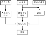
具体实施中,本申请实施例中的终端可以是指各种机器人、导盲头盔或者其他可以参与到地图标注的其他终端。这里的终端可以包括摄像头,GPS、WIFI等可以用于实现定位的功能模块以及与其连接的人机交互设备。其中,人机交互设备可以是麦克风、键盘、鼠标、触摸屏等等,可以通过接收用户的指令(可以包括语音、图像和文字等等)的方式向终端输入地图标注相关数据。摄像头也可以作为人机交互设备将采集到的地图标注相关数据(图像)输入至终端。其中,摄像头或定位的功能模块还可以采集用于建图的建图相关数据。In a specific implementation, the terminal in the embodiment of the present application may refer to various robots, guide helmets, or other terminals that can participate in map annotation. The terminal here may include a camera, a function module that can be used for positioning, such as GPS, WIFI, and the like, and a human-machine interaction device connected thereto. The human-computer interaction device may be a microphone, a keyboard, a mouse, a touch screen, or the like, and may input the map label related data to the terminal by receiving a user's instruction (which may include voice, image, text, etc.). The camera can also input the collected map annotation related data (image) as a human-machine interaction device to the terminal. Among them, the camera or the positioning function module can also collect the drawing related data for drawing.
云端服务器侧从终端侧接收该终端同时在同一地理位置采集的地图标注相关数据和建图相关数据,并通过步骤102和步骤103分别对地图标注相关数据和建图相关数据进行处理,以确定与当前的地图标注相关数据和建图相关数据相对应的地理位置和地图标注信息,最后,将所述地图标注信息标注于所述建图结果中的所述地理位置上,完成建图和地图标注。The cloud server side receives the map data and the mapping related data collected by the terminal at the same geographical location from the terminal side, and processes the related data and the mapping related data of the map by step 102 and step 103 respectively to determine and The current map labels the relevant data and the map-related information corresponding to the map-related data, and finally, the map label information is marked on the geographic location in the map-forming result, and the map and map label are completed. .
其中,步骤102和步骤103的执行不分先后顺序,也可以同时执行。The execution of step 102 and step 103 is performed in no particular order, and may also be performed simultaneously.
针对目前地图标注方案中存在的问题,本申请实施例所提供的地图标注的方法,通过接收来自终端的地图标注相关数据和建图相关数据;所述地图标注相关数据与所述建图相关数据是所述终端同时在同一地理位置采集的,二者一一对应;根据所述建图相关数据进行建图,并根据所述建图结果确定地理位置;根据所述地图标注相关数据确定地图标注信息;将所述地图标注信息标注于所述建图结果中的所述地理位置上,可以通过对终端上传的地图标注相关数据和建图相关数据进行处理以实现地图建图和地 图标注同时进行,并可以有效地提高地图标注的效率。For the problem existing in the current map labeling scheme, the method for map labeling provided by the embodiment of the present application receives relevant data and construction related data by using a map from the terminal; the map labeling related data and the related data of the mapping The terminal is collected at the same geographical location at the same time, and the two are corresponding to each other; the mapping is performed according to the construction related data, and the geographic location is determined according to the mapping result; and the map annotation is determined according to the map labeling relevant data. The information is marked on the geographical location in the result of the mapping, and the related data and the related data of the mapping uploaded by the terminal may be processed to realize the mapping of the map and the marking of the map simultaneously. And can effectively improve the efficiency of map annotation.
实施中,根据所述建图相关数据进行建图,可以具体包括:In the implementation, the mapping according to the data related to the drawing may specifically include:
对所述建图相关数据进行解析;Parsing the mapping related data;
采用建图算法对解析后的数据进行处理,得到所述终端的运动轨迹实现建图。The parsing algorithm is used to process the parsed data, and the motion track of the terminal is obtained to construct a map.
具体实施中,根据所述建图相关数据进行建图,首先需要对图像、经纬度坐标、高度坐标、方向数据等的建图相关数据进行相应地解析处理后,可以采用vSLAM(visual simultaneous localization and mapping,基于视觉的即时定位与地图构建)、SFM等基于视觉的建图算法或者是基于其他传感器的建图算法进行建图,以得到该终端的运动轨迹。这里对具体的建图算法不作具体限定。In a specific implementation, according to the data related to the construction of the drawing, the mapping data related to the image, the latitude and longitude coordinates, the height coordinate, the direction data, and the like need to be correspondingly analyzed, and then the vSLAM (visual simultaneous localization and mapping) may be used. , based on visual real-time positioning and map construction), SFM or other visual-based mapping algorithm or mapping algorithm based on other sensors to obtain the motion trajectory of the terminal. The specific mapping algorithm is not specifically limited here.
实施中,根据所述地图标注相关数据确定地图标注信息,可以具体包括:In the implementation, determining the map annotation information according to the map labeling related data may specifically include:
对所述地图标注相关数据进行解析;所述地图标注相关数据至少包括语音数据、图像数据、文字数据、触摸轨迹数据中的一种;Parsing the map with relevant data for analysis; the map label related data includes at least one of voice data, image data, text data, and touch track data;
根据解析结果确定地图标注信息。The map annotation information is determined according to the analysis result.
具体实施中,根据所述地图标注相关数据确定地图标注信息,可以将由摄像头、麦克风、触摸板、鼠标、键盘等输入到该终端的地图标注相关信息进行相应地解析,然后根据解析结果确定地图标注信息。In a specific implementation, the map annotation information is determined according to the map label related data, and the map input information input to the terminal by the camera, the microphone, the touchpad, the mouse, the keyboard, and the like may be correspondingly analyzed, and then the map annotation is determined according to the analysis result. information.
基于同一发明构思,本申请实施例中还提供了一种地图标注的装置,由于这些设备解决问题的原理与上述可以应用在云端服务器侧的地图标注的方法相似,因此这些设备的实施可以参见方法的实施,重复之处不再赘述。Based on the same inventive concept, the embodiment of the present application further provides a device for map labeling. Since the principle of solving the problem of these devices is similar to the method for map labeling that can be applied to the cloud server side, the implementation of these devices can be referred to the method. The implementation, repetitions will not be repeated.
图3示出了本申请实施例中提供的可以应用于云端服务器侧地图标注的装置,如图3所示,该地图标注的装置可以包括:FIG. 3 shows an apparatus that can be applied to a cloud server side map annotation provided in the embodiment of the present application. As shown in FIG. 3, the apparatus marked by the map may include:
接收模块301,用于接收来自终端的地图标注相关数据和建图相关数据;所述地图标注相关数据与所述建图相关数据是所述终端同时在同一地理位置采集的,二者一一对应;The receiving module 301 is configured to receive map annotation related data and mapping related data from the terminal; the map annotation related data and the mapping related data are collected by the terminal at the same geographical location at the same time, and the two are corresponding to each other. ;
第一位置模块302,用于根据所述建图相关数据进行建图,并根据所述建图结果确定地理位置;The first location module 302 is configured to perform mapping according to the mapping related data, and determine a geographic location according to the mapping result;
第一标注信息模块303,用于根据所述地图标注相关数据确定地图标注信息;The first label information module 303 is configured to determine map label information according to the map label related data;
第一标注处理模块304,用于将所述地图标注信息标注于所述建图结果中的所述地理位置上。The first annotation processing module 304 is configured to mark the map annotation information on the geographic location in the mapping result.
实施中,所述第一位置模块可以具体用于对所述建图相关数据进行解析;采用建图算法对解析后的数据进行处理,得到所述终端的运动轨迹实现建图。In an implementation, the first location module may be specifically configured to parse the mapping related data; and the parsing algorithm is used to process the parsed data to obtain a motion trajectory of the terminal to construct a graph.
实施中,所述第一标注信息模块可以具体用于对所述地图标注相关数据进行解析;所述地图标注相关数据至少包括语音数据、图像数据、文字数据、触摸轨迹数据中的一种;根据解析结果确定地图标注信息。In an implementation, the first label information module may be specifically configured to parse the map label related data; the map label related data includes at least one of voice data, image data, text data, and touch track data; The analysis result determines the map annotation information.
基于同一发明构思,本申请实施例中还提供了一种用于执行地图标注的方法的云端服务器。Based on the same inventive concept, a cloud server for performing a method for map annotation is also provided in the embodiment of the present application.
图5为本申请实施例中提供的云端服务器的结构示意图,如图5所示,该云端服务器500可以包括:通信模块501,存储器502,一个或多个处理器503;以及一个或多个模块,所述一个或多个模块被存储在所述存储器中,并被配置成由所述一个或多个处理器执行,所述一个或多个模块包括用于执行上述可以应用于云端服务器侧的地图标注的方法中各个步骤的指令。5 is a schematic structural diagram of a cloud server provided in an embodiment of the present application. As shown in FIG. 5, the cloud server 500 may include: a communication module 501, a memory 502, one or more processors 503, and one or more modules. The one or more modules are stored in the memory and configured to be executed by the one or more processors, the one or more modules including for performing the above-described application that can be applied to the cloud server side The instructions for each step in the method of map annotation.
基于同一发明构思,本申请实施例中还提供了一种与上述云端服务器结合使用的应用程序,给应用程序可以包括内嵌于计算机可读的存储介质中的计算机程序,所述计算机程序包括用于使所述云端服务器执行上述可 以应用于云端服务器侧的地图标注的方法中的各个步骤的指令。Based on the same inventive concept, an application program used in combination with the above cloud server is further provided in the embodiment of the present application, and the application program may include a computer program embedded in a computer readable storage medium, where the computer program includes And causing the cloud server to execute the instructions of each step in the method that can be applied to the map annotation on the cloud server side.
本申请实施例提出了地图标注的方法,该地图标注的方法也可以应用于终端侧,下面进行说明。The embodiment of the present application proposes a method for map labeling, and the method for labeling the map can also be applied to the terminal side, which will be described below.
图2示出了本申请实施例中提供的可以应用于终端侧的地图标注的方法的流程示意图,如图2所示,该地图标注的方法可以包括如下步骤:FIG. 2 is a schematic flowchart of a method for applying map annotations that can be applied to a terminal side provided in the embodiment of the present application. As shown in FIG. 2, the method for marking the map may include the following steps:
步骤201、通过人机交互设备获取地图标注相关数据和建图相关数据;所述地图标注相关数据与所述建图相关数据是所述人机交互设备在同一地理位置采集的,二者一一对应;Step 201: Obtain map annotation related data and construction related data through a human-machine interaction device; the map annotation related data and the mapping related data are collected by the human-machine interaction device in the same geographical location, and the two are one by one correspond;
步骤202、根据所述建图相关数据进行建图,并根据所述建图结果确定地理位置;Step 202: Perform a mapping according to the data related to the mapping, and determine a geographic location according to the result of the mapping;
步骤203、根据所述地图标注相关数据确定地图标注信息;Step 203: Determine map annotation information according to the map label related data.
步骤204、将所述地图标注信息标注于所述建图结果中的所述地理位置上。Step 204: Label the map labeling information on the geographic location in the mapping result.
具体实施中,可以应用于终端侧的地图标注的方法与上述可以应用于云端服务器侧的地图标注的方法的原理大体相同,差别在于,上述可以应用于云端服务器侧的地图标注的方法是由终端侧采集地图标注相关数据和建图相关数据并发送至云端服务器,利用云端服务器强大的数据处理能力进行地图标注相关数据和建图相关数据的后续处理,最终实现地图建图和地图标注。In a specific implementation, the method applicable to the map labeling on the terminal side is substantially the same as the method of the map labeling method applicable to the cloud server side, and the difference is that the method for mapping the map that can be applied to the cloud server side is performed by the terminal. The side collects the map to mark the relevant data and the related data of the construction and sends it to the cloud server, and utilizes the powerful data processing capability of the cloud server to perform subsequent processing of the map annotation related data and the construction related data, and finally realizes the map construction and the map annotation.
而图2示出的可以应用于终端侧的地图标注的方法,则是终端侧采集地图标注相关数据和建图相关数据后,由终端自行处理,而无需发送至云端服务器。The method of the map labeling that can be applied to the terminal side shown in FIG. 2 is that after the terminal side collects the map label related data and the map related data, the terminal processes the data by itself without sending to the cloud server.
有益效果:Beneficial effects:
针对目前地图标注方案中存在的问题,本申请实施例所提供的地图标注的方法,可以通过人机交互设备获取地图标注相关数据和建图相关数据; 所述地图标注相关数据与所述建图相关数据是所述人机交互设备在同一地理位置采集的,二者一一对应;根据所述建图相关数据进行建图,并根据所述建图结果确定地理位置;根据所述地图标注相关数据确定地图标注信息;将所述地图标注信息标注于所述建图结果中的所述地理位置上,可以实现终端通过人机交互设备采集地图标注相关数据和建图相关数据,对地图标注相关数据和建图相关数据进行处理以实现地图建图和地图标注同时进行,并可以有效地提高地图标注的效率。For the problem existing in the current map labeling scheme, the map labeling method provided by the embodiment of the present application may acquire the map label related data and the map related data through the human-machine interaction device; the map labeling related data and the mapping The related data is collected by the human-machine interaction device in the same geographical location, and the two are corresponding to each other; the mapping is performed according to the construction related data, and the geographical location is determined according to the mapping result; The data is used to determine the map labeling information; the map labeling information is marked on the geographical location in the mapping result, and the terminal can collect the map labeling related data and the drawing related data through the human-machine interaction device, and mark the map related information. Data and mapping related data are processed to achieve simultaneous mapping of maps and maps, and the efficiency of map annotation can be effectively improved.
实施中,根据所述建图相关数据进行建图可以具体包括:In the implementation, the mapping according to the data related to the mapping may specifically include:
对所述建图相关数据进行解析;Parsing the mapping related data;
采用建图算法对解析后的数据进行处理;The parsed algorithm is used to process the parsed data;
得到所述终端的运动轨迹实现建图。Obtaining a motion trajectory of the terminal to achieve mapping.
实施中,根据所述地图标注相关数据确定地图标注信息可以具体包括:In the implementation, determining the map annotation information according to the map label related data may specifically include:
对所述地图标注相关数据进行解析;所述地图标注相关数据至少包括语音数据、图像数据、文字数据、触摸轨迹数据中的一种;Parsing the map with relevant data for analysis; the map label related data includes at least one of voice data, image data, text data, and touch track data;
根据解析结果确定地图标注信息。The map annotation information is determined according to the analysis result.
基于同一发明构思,本申请实施例中还提供了一种地图标注的装置,由于这些设备解决问题的原理与上述可以应用在终端侧的地图标注的方法相似,因此这些设备的实施可以参见方法的实施,重复之处不再赘述。Based on the same inventive concept, an apparatus for map labeling is also provided in the embodiment of the present application. Since the principle of solving the problem of these devices is similar to the method of the map labeling that can be applied to the terminal side, the implementation of these devices can be referred to the method. Implementation, repetition will not be repeated.
图4示出了本申请实施例中提供的可以应用于终端侧地图标注的装置的结构示意图,如图4所示,该地图标注的装置可以包括:FIG. 4 is a schematic structural diagram of an apparatus that can be applied to a terminal side map annotation provided in the embodiment of the present application. As shown in FIG. 4, the apparatus marked by the map may include:
获取模块401,用于通过人机交互设备获取地图标注相关数据和建图相关数据;所述地图标注相关数据与所述建图相关数据是所述人机交互设备在同一地理位置采集的,二者一一对应;The obtaining module 401 is configured to acquire the map label related data and the map related data by using the human-machine interaction device; the map label related data and the map-related data are collected by the human-machine interaction device in the same geographical location, One-to-one correspondence;
第二位置模块402,用于根据所述建图相关数据进行建图,并根据所述建图结果确定地理位置;a second location module 402, configured to perform a mapping according to the mapping related data, and determine a geographic location according to the mapping result;
第二标注信息模块403,用于根据所述地图标注相关数据确定地图标注信息;a second label information module 403, configured to determine map label information according to the map label related data;
第二标注处理模块404,用于将所述地图标注信息标注于所述建图结果中的所述地理位置上。The second annotation processing module 404 is configured to mark the map annotation information on the geographic location in the mapping result.
实施中,所述第二位置模块可以具体用于对所述建图相关数据进行解析;采用建图算法对解析后的数据进行处理;得到所述终端的运动轨迹实现建图。In an implementation, the second location module may be specifically configured to parse the mapping related data; the parsing algorithm is used to process the parsed data; and the motion trajectory of the terminal is obtained to construct a graph.
实施中,第二标注信息模块可以具体用于对所述地图标注相关数据进行解析;所述地图标注相关数据至少包括语音数据、图像数据、文字数据、触摸轨迹数据中的一种;根据解析结果确定地图标注信息。In the implementation, the second label information module may be specifically configured to parse the map label related data; the map label related data includes at least one of voice data, image data, text data, and touch track data; Determine map annotation information.
基于同一发明构思,本申请实施例中还提供了一种用于执行上述地图标注的方法的终端。Based on the same inventive concept, a terminal for performing the above method of map annotation is further provided in the embodiment of the present application.
图6为本申请实施例中提供的终端的结构示意图,如图6所示,该终端600可以包括:通信模块601,存储器602,一个或多个处理器603;以及一个或多个模块,所述一个或多个模块被存储在所述存储器中,并被配置成由所述一个或多个处理器执行,所述一个或多个模块包括用于执行上述可以应用在终端侧的地图标注的方法中各个步骤的指令。FIG. 6 is a schematic structural diagram of a terminal provided in an embodiment of the present application. As shown in FIG. 6, the terminal 600 may include: a communication module 601, a memory 602, one or more processors 603, and one or more modules. Said one or more modules are stored in said memory and configured to be executed by said one or more processors, said one or more modules comprising means for performing said map annotations that are applicable to the terminal side The instructions for each step in the method.
基于同一发明构思,本申请实施例中还提供了一种与上述终端结合使用的应用程序,所述应用程序包括内嵌于计算机可读的存储介质中的计算机程序,所述计算机程序包括用于使所述终端执行上述可以应用在终端侧的地图标注的方法中的各个步骤的指令。Based on the same inventive concept, an application program used in combination with the above terminal is further provided in the embodiment of the present application, where the application program includes a computer program embedded in a computer readable storage medium, and the computer program includes The terminal is caused to execute the above-described instructions of each step in the method of map annotation that can be applied to the terminal side.
实施例1Example 1
图7为本申请实施例中提供的地图标注的方法的实施例图一,如图7所示,参与数据采集的设备包括:人机交互设备(至少包括摄像头),其他传感器模块。人机交互设备可以包括:键盘,鼠标,触摸屏幕,图像或视 频交互设备或者语音交互设备等,通过人机交互设备采集来自人的指令,并将其处理识别为人工输入路标的信息。比如,当人机交互设备为麦克风时,麦克风采集到来自用户的语音信息“这里是超市”,即,实现人工输入路标,标记该位置的路标信息为“超市”。FIG. 7 is a first embodiment of a method for mapping a map provided in an embodiment of the present invention. As shown in FIG. 7 , the device for participating in data collection includes: a human-machine interaction device (including at least a camera), and other sensor modules. The human-machine interaction device may include: a keyboard, a mouse, a touch screen, an image or a video interaction device or a voice interaction device, etc., and the human-computer interaction device collects instructions from the person and recognizes the processing as information for manually inputting the road sign. For example, when the human-machine interaction device is a microphone, the microphone collects the voice information “here is a supermarket” from the user, that is, the manual input of the road sign is realized, and the road sign information marking the location is “supermarket”.
而摄像头可以有两个作用。一、采集该位置是“超市”还是“饭馆”等路标信息的图像,供后续的场景识别模块进行场景理解和分析以得到图像识别路标;二、摄像头也可以采集建图相关的图像数据供后续vSLAM建图处理。其他传感器,例如激光雷达,GPS,IMU(Inertial measurement unit,惯导等待传感器)等可以采集用于地图创建的地图建图相关数据。The camera can have two functions. 1. Collecting the image of the landmark information such as “supermarket” or “restaurant” for subsequent scene recognition module to understand and analyze the scene to obtain image recognition roadmap; second, the camera can also collect image data related to the construction for subsequent vSLAM construction processing. Other sensors, such as laser radar, GPS, IMU (Inertial Measurement Unit), etc., can collect map construction related data for map creation.
人工路标记录了人工交互设备输入的地图路标相关数据,对人工路标记录信息进行处理并识别出地图标注信息。The artificial road sign records the map roadmap related data input by the human interaction device, processes the artificial road sign record information and recognizes the map label information.
通过对摄像头或其他传感器采集的建图相关数据的解析与处理,可以完成建图,得到终端的运动轨迹地图。Through the analysis and processing of the data related to the construction of the camera or other sensors, the construction of the map can be completed, and the motion trajectory map of the terminal can be obtained.
最后将地图标注信息融合到地图的相应位置上,得到完整的地图和对应的路标信息。Finally, the map annotation information is merged into the corresponding position of the map to obtain a complete map and corresponding road sign information.
在地图标注信息处理的过程中,本领域技术人员可以结合实际情况,综合对摄像头采集的图像识别路标的结果以及其他人机交互设备采集的地图标注相关数据的处理结果来确定最终的地图标注信息。In the process of map label information processing, those skilled in the art can comprehensively determine the final map labeling information by comprehensively analyzing the result of the image recognition road sign collected by the camera and the processing result of the map label related data collected by other human-computer interaction devices. .
地图标注相关数据和建图相关数据的处理具体是由终端侧完成,还是云端服务器侧完成,也可以将地图标注相关数据和建图相关数据的处理分别由终端和云端服务器侧单独进行处理,本领域技术人员可以根据实际情况灵活选择,这里不做具体限定。The processing of the map label related data and the construction related data is specifically completed by the terminal side or by the cloud server side, and the processing of the map label related data and the construction related data may be separately processed by the terminal and the cloud server side respectively. The technical personnel in the field can flexibly choose according to the actual situation, and no specific limitation is made here.
实施例2Example 2
图8为本申请实施例中提供的地图标注的方法的实施例图二,假设该终端为云端导盲头盔。如图8所示,云端导盲头盔可以包括摄像头,麦克 风模块和发送端模块,发送端将采集得到的用于建图或地图标注的图像数据和用于地图标注的语音信号发送至云端服务器。在云端服务器中设有图像数据和语音数据的接收和解析处理模块,可以将图像数据分别送至建图处理模块和地图标注识别模块,建图模块运行vSLAM方法建图输出运动轨迹,识别模块运行场景理解输出自动路标信息,语音信息进行语音识别和处理输出人工路标信息,最终将上述路标信息(地图标注信息)标注到地图上,形成完整的地图信息。FIG. 8 is a second embodiment of a method for map labeling provided in an embodiment of the present application. It is assumed that the terminal is a cloud-guided helmet. As shown in FIG. 8, the cloud-guided helmet can include a camera, a microphone module, and a transmitting module. The transmitting end sends the collected image data for mapping or map marking and the voice signal for map labeling to the cloud server. The image server and the voice data receiving and parsing processing module are provided in the cloud server, and the image data can be respectively sent to the drawing processing module and the map label identifying module, and the drawing module runs the vSLAM method to construct the graph output motion track, and the identification module runs. The scene understanding outputs automatic road sign information, the voice information performs voice recognition and processing and outputs artificial road sign information, and finally the above road sign information (map mark information) is marked on the map to form complete map information.
实施例3Example 3
图9为本申请实施例中提供的地图标注的方法的实施例图三,假设地图标注的方案是基于现有的地图数据库。如图9所示,地图库数据为现有数据库,比如高德、百度等地图厂商提供的地图数据库。终端可以包括摄像头,麦克风模块和GPS定位模块。终端将图像送至识别模块,识别模块对图像进行识别处理输出(自动识别)路标信息1。对由麦克风采集的语音信息进行语音识别和处理输出(人工)路标信息2,GPS定位目前上述路标信息1和2所对应的位置,并且在地图上给出相应的位置信息。综合路标信息1和2后得到最终的地图标注信息,并将该地图标注信息标注到地图上相应的位置信息,形成完整的地图信息。FIG. 9 is a third embodiment of a method for map labeling provided in an embodiment of the present application. It is assumed that the map labeling scheme is based on an existing map database. As shown in FIG. 9, the map data is an existing database, such as a map database provided by a map manufacturer such as Gaode and Baidu. The terminal can include a camera, a microphone module, and a GPS positioning module. The terminal sends the image to the identification module, and the recognition module performs recognition processing on the image to output (automatically recognize) the landmark information 1. The voice information collected by the microphone is subjected to voice recognition and processing output (manual) landmark information 2, and the GPS locates the position corresponding to the above-mentioned road sign information 1 and 2, and gives corresponding position information on the map. After the comprehensive road sign information 1 and 2, the final map labeling information is obtained, and the map labeling information is marked to the corresponding position information on the map to form complete map information.
其中,上述方案中的GPS模块可以换成WIFI等无线定位模块,从而实现在室内的地图标注。The GPS module in the above solution can be replaced by a wireless positioning module such as WIFI, thereby realizing map annotation in the room.
本申请实施例提供的地图标注方法,能够实时在线建图和路标标注,效率高;能够将人工和自主识别路标结合,生成更加准确的地图,且不需要专业的地图制图人员进行操作。The map labeling method provided by the embodiment of the present application can real-time online construction and road marking, and has high efficiency; can combine artificial and self-identifying road signs to generate more accurate maps, and does not require professional map drawing personnel to operate.
本领域内的技术人员应明白,本申请的实施例可提供为方法、系统、或计算机程序产品。因此,本申请可采用完全硬件实施例、完全软件实施例、或结合软件和硬件方面的实施例的形式。而且,本申请可采用在一个 或多个其中包含有计算机可用程序代码的计算机可用存储介质(包括但不限于磁盘存储器、CD-ROM、光学存储器等)上实施的计算机程序产品的形式。Those skilled in the art will appreciate that embodiments of the present application can be provided as a method, system, or computer program product. Thus, the present application can take the form of an entirely hardware embodiment, an entirely software embodiment, or an embodiment in combination of software and hardware. Moreover, the application can take the form of a computer program product embodied on one or more computer-usable storage media (including but not limited to disk storage, CD-ROM, optical storage, etc.) including computer usable program code.
本申请是参照根据本申请实施例的方法、设备(系统)、和计算机程序产品的流程图和/或方框图来描述的。应理解可由计算机程序指令实现流程图和/或方框图中的每一流程和/或方框、以及流程图和/或方框图中的流程和/或方框的结合。可提供这些计算机程序指令到通用计算机、专用计算机、嵌入式处理机或其他可编程数据处理设备的处理器以产生一个机器,使得通过计算机或其他可编程数据处理设备的处理器执行的指令产生用于实现在流程图一个流程或多个流程和/或方框图一个方框或多个方框中指定的功能的装置。The present application is described with reference to flowchart illustrations and/or block diagrams of methods, apparatus (system), and computer program products according to embodiments of the present application. It will be understood that each flow and/or block of the flowchart illustrations and/or FIG. These computer program instructions can be provided to a processor of a general purpose computer, special purpose computer, embedded processor, or other programmable data processing device to produce a machine for the execution of instructions for execution by a processor of a computer or other programmable data processing device. Means for implementing the functions specified in one or more of the flow or in a block or blocks of the flow chart.
这些计算机程序指令也可存储在能引导计算机或其他可编程数据处理设备以特定方式工作的计算机可读存储器中,使得存储在该计算机可读存储器中的指令产生包括指令装置的制造品,该指令装置实现在流程图一个流程或多个流程和/或方框图一个方框或多个方框中指定的功能。The computer program instructions can also be stored in a computer readable memory that can direct a computer or other programmable data processing device to operate in a particular manner, such that the instructions stored in the computer readable memory produce an article of manufacture comprising the instruction device. The apparatus implements the functions specified in one or more blocks of a flow or a flow and/or block diagram of the flowchart.
这些计算机程序指令也可装载到计算机或其他可编程数据处理设备上,使得在计算机或其他可编程设备上执行一系列操作步骤以产生计算机实现的处理,从而在计算机或其他可编程设备上执行的指令提供用于实现在流程图一个流程或多个流程和/或方框图一个方框或多个方框中指定的功能的步骤。These computer program instructions can also be loaded onto a computer or other programmable data processing device such that a series of operational steps are performed on a computer or other programmable device to produce computer-implemented processing for execution on a computer or other programmable device. The instructions provide steps for implementing the functions specified in one or more of the flow or in a block or blocks of a flow diagram.
尽管已描述了本申请的优选实施例,但本领域内的技术人员一旦得知了基本创造性概念,则可对这些实施例作出另外的变更和修改。所以,所附权利要求意欲解释为包括优选实施例以及落入本申请范围的所有变更和修改。While the preferred embodiment of the present application has been described, it will be apparent that those skilled in the art can make further changes and modifications to the embodiments. Therefore, the appended claims are intended to be interpreted as including the preferred embodiments and the modifications and
Claims (16)
- 一种地图标注的方法,其特征在于,包括如下步骤:A method for map labeling, comprising the steps of:接收来自终端的地图标注相关数据和建图相关数据;所述地图标注相关数据与所述建图相关数据是所述终端同时在同一地理位置采集的,二者一一对应;Receiving map annotation related data and construction related data from the terminal; the map annotation related data and the mapping related data are collected by the terminal at the same geographical position at the same time, and the two are corresponding to each other;根据所述建图相关数据进行建图,并根据所述建图结果确定地理位置;Performing a mapping according to the data related to the drawing, and determining a geographic location according to the result of the mapping;根据所述地图标注相关数据确定地图标注信息;Determining map annotation information according to the map label related data;将所述地图标注信息标注于所述建图结果中的所述地理位置上。The map annotation information is marked on the geographic location in the mapping result.
- 如权利要求1所述的地图标注的方法,其特征在于,根据所述建图相关数据进行建图,具体包括:The map labeling method according to claim 1, wherein the mapping is performed according to the mapping related data, which specifically includes:对所述建图相关数据进行解析;Parsing the mapping related data;采用建图算法对解析后的数据进行处理,得到所述终端的运动轨迹实现建图。The parsing algorithm is used to process the parsed data, and the motion track of the terminal is obtained to construct a map.
- 如权利要求1所述的地图标注的方法,其特征在于,根据所述地图标注相关数据确定地图标注信息,具体包括:The map labeling method according to claim 1, wherein the determining the map labeling information according to the map labeling related data comprises:对所述地图标注相关数据进行解析;所述地图标注相关数据至少包括语音数据、图像数据、文字数据、触摸轨迹数据中的一种;Parsing the map with relevant data for analysis; the map label related data includes at least one of voice data, image data, text data, and touch track data;根据解析结果确定地图标注信息。The map annotation information is determined according to the analysis result.
- 一种地图标注的方法,其特征在于,包括如下步骤:A method for map labeling, comprising the steps of:通过人机交互设备获取地图标注相关数据和建图相关数据;所述地图标注相关数据与所述建图相关数据是所述人机交互设备在同一地理位置采集的,二者一一对应;Obtaining map annotation related data and construction related data through the human-machine interaction device; the map annotation related data and the mapping related data are collected by the human-computer interaction device in the same geographical location, and the two are corresponding to each other;根据所述建图相关数据进行建图,并根据所述建图结果确定地理位置;Performing a mapping according to the data related to the drawing, and determining a geographic location according to the result of the mapping;根据所述地图标注相关数据确定地图标注信息;Determining map annotation information according to the map label related data;将所述地图标注信息标注于所述建图结果中的所述地理位置上。The map annotation information is marked on the geographic location in the mapping result.
- 如权利要求4所述的地图标注的方法,其特征在于,根据所述建图相关数据进行建图,具体包括:The map labeling method according to claim 4, wherein the mapping is performed according to the mapping related data, which specifically includes:对所述建图相关数据进行解析;Parsing the mapping related data;采用建图算法对解析后的数据进行处理;The parsed algorithm is used to process the parsed data;得到所述终端的运动轨迹实现建图。Obtaining a motion trajectory of the terminal to achieve mapping.
- 如权利要求4所述的地图标注的方法,其特征在于,根据所述地图标注相关数据确定地图标注信息,具体包括:The map labeling method according to claim 4, wherein determining the map labeling information according to the map labeling related data comprises:对所述地图标注相关数据进行解析;所述地图标注相关数据至少包括语音数据、图像数据、文字数据、触摸轨迹数据中的一种;Parsing the map with relevant data for analysis; the map label related data includes at least one of voice data, image data, text data, and touch track data;根据解析结果确定地图标注信息。The map annotation information is determined according to the analysis result.
- 一种地图标注的装置,其特征在于,包括:A device for map labeling, comprising:接收模块,用于接收来自终端的地图标注相关数据和建图相关数据;所述地图标注相关数据与所述建图相关数据是所述终端同时在同一地理位置采集的,二者一一对应;a receiving module, configured to receive map annotation related data and mapping related data from the terminal; the map annotation related data and the mapping related data are collected by the terminal at the same geographical location at the same time, and the two are corresponding to each other;第一位置模块,用于根据所述建图相关数据进行建图,并根据所述建图结果确定地理位置;a first location module, configured to perform mapping according to the mapping related data, and determine a geographic location according to the mapping result;第一标注信息模块,用于根据所述地图标注相关数据确定地图标注信息;a first label information module, configured to determine map label information according to the map label related data;第一标注处理模块,用于将所述地图标注信息标注于所述建图结果中的所述地理位置上。The first annotation processing module is configured to mark the map annotation information on the geographic location in the mapping result.
- 如权利要求7所述的地图标注的装置,其特征在于,所述第一位置模块具体用于对所述建图相关数据进行解析;采用建图算法对解析后的数据进行处理,得到所述终端的运动轨迹实现建图。The apparatus for map annotation according to claim 7, wherein the first location module is specifically configured to parse the mapping related data; and the parsing algorithm is used to process the parsed data to obtain the The motion track of the terminal realizes the construction.
- 如权利要求7所述的地图标注的装置,其特征在于,所述第一标注信息模块具体用于对所述地图标注相关数据进行解析;所述地图标注相关 数据至少包括语音数据、图像数据、文字数据、触摸轨迹数据中的一种;根据解析结果确定地图标注信息。The device for map annotation according to claim 7, wherein the first annotation information module is specifically configured to parse the map annotation related data; the map annotation related data includes at least voice data, image data, One of text data and touch track data; the map annotation information is determined according to the analysis result.
- 一种地图标注的装置,其特征在于,包括:A device for map labeling, comprising:获取模块,用于通过人机交互设备获取地图标注相关数据和建图相关数据;所述地图标注相关数据与所述建图相关数据是所述人机交互设备在同一地理位置采集的,二者一一对应;An acquiring module, configured to acquire map annotation related data and construction related data by using a human-machine interaction device; the map annotation related data and the mapping related data are collected by the human-machine interaction device in the same geographical location, and the two One-to-one correspondence;第二位置模块,用于根据所述建图相关数据进行建图,并根据所述建图结果确定地理位置;a second location module, configured to perform a mapping according to the mapping related data, and determine a geographic location according to the mapping result;第二标注信息模块,用于根据所述地图标注相关数据确定地图标注信息;a second label information module, configured to determine map label information according to the map label related data;第二标注处理模块,用于将所述地图标注信息标注于所述建图结果中的所述地理位置上。And a second annotation processing module, configured to mark the map annotation information on the geographic location in the mapping result.
- 如权利要求10所述的地图标注的装置,其特征在于,所述第二位置模块具体用于对所述建图相关数据进行解析;采用建图算法对解析后的数据进行处理;得到所述终端的运动轨迹实现建图。The device for map annotation according to claim 10, wherein the second location module is specifically configured to parse the mapping related data; and the parsing algorithm is used to process the parsed data; The motion track of the terminal realizes the construction.
- 如权利要求10所述的地图标注的装置,其特征在于,第二标注信息模块具体用于对所述地图标注相关数据进行解析;所述地图标注相关数据至少包括语音数据、图像数据、文字数据、触摸轨迹数据中的一种;根据解析结果确定地图标注信息。The apparatus for marking a map according to claim 10, wherein the second annotation information module is specifically configured to parse the map annotation related data; the map annotation related data includes at least voice data, image data, and text data. And touching one of the trajectory data; determining the map annotation information according to the analysis result.
- 一种云端服务器,其特征在于,所述云端服务器包括:通信模块,存储器,一个或多个处理器;以及一个或多个模块,所述一个或多个模块被存储在所述存储器中,并被配置成由所述一个或多个处理器执行,所述一个或多个模块包括用于执行权利要求1-3中任一所述方法中各个步骤的指令。A cloud server, comprising: a communication module, a memory, one or more processors; and one or more modules, the one or more modules being stored in the memory, and It is configured to be executed by the one or more processors, the one or more modules comprising instructions for performing the various steps of the method of any of claims 1-3.
- 一种与如权利要求13所述的云端服务器结合使用的应用程序,所 述应用程序包括内嵌于计算机可读的存储介质中的计算机程序,所述计算机程序包括用于使所述云端服务器执行权利要求1至3中任一所述方法中的各个步骤的指令。An application program for use in conjunction with the cloud server of claim 13, the application program comprising a computer program embedded in a computer readable storage medium, the computer program comprising means for causing the cloud server to execute The instructions of the various steps in the method of any one of claims 1 to 3.
- 一种终端,其特征在于,所述终端包括:通信模块,存储器,一个或多个处理器;以及一个或多个模块,所述一个或多个模块被存储在所述存储器中,并被配置成由所述一个或多个处理器执行,所述一个或多个模块包括用于执行权利要求4至6中任一所述方法中各个步骤的指令。A terminal, comprising: a communication module, a memory, one or more processors; and one or more modules, the one or more modules being stored in the memory and configured The instructions are executed by the one or more processors, the one or more modules comprising instructions for performing the various steps of the method of any of claims 4-6.
- 一种与如权利要求15所述的终端结合使用的应用程序,所述应用程序包括内嵌于计算机可读的存储介质中的计算机程序,所述计算机程序包括用于使所述终端执行权利要求4至6中任一所述方法中的各个步骤的指令。An application for use in conjunction with the terminal of claim 15, the application comprising a computer program embedded in a computer readable storage medium, the computer program comprising means for causing the terminal to execute the claim The instructions of the various steps in any of the methods 4 to 6.
Priority Applications (2)
| Application Number | Priority Date | Filing Date | Title |
|---|---|---|---|
| PCT/CN2017/120036 WO2019127437A1 (en) | 2017-12-29 | 2017-12-29 | Map labeling method and apparatus, and cloud server, terminal and application program |
| CN201780002724.1A CN108124479A (en) | 2017-12-29 | 2017-12-29 | Map labeling method and device, cloud server, terminal and application program |
Applications Claiming Priority (1)
| Application Number | Priority Date | Filing Date | Title |
|---|---|---|---|
| PCT/CN2017/120036 WO2019127437A1 (en) | 2017-12-29 | 2017-12-29 | Map labeling method and apparatus, and cloud server, terminal and application program |
Publications (1)
| Publication Number | Publication Date |
|---|---|
| WO2019127437A1 true WO2019127437A1 (en) | 2019-07-04 |
Family
ID=62233595
Family Applications (1)
| Application Number | Title | Priority Date | Filing Date |
|---|---|---|---|
| PCT/CN2017/120036 WO2019127437A1 (en) | 2017-12-29 | 2017-12-29 | Map labeling method and apparatus, and cloud server, terminal and application program |
Country Status (2)
| Country | Link |
|---|---|
| CN (1) | CN108124479A (en) |
| WO (1) | WO2019127437A1 (en) |
Families Citing this family (3)
| Publication number | Priority date | Publication date | Assignee | Title |
|---|---|---|---|---|
| CN109540122B (en) * | 2018-11-14 | 2022-11-04 | 中国银联股份有限公司 | Method and device for constructing map model |
| CN111415410B (en) * | 2019-01-08 | 2023-06-20 | 阿里巴巴集团控股有限公司 | POI (Point of interest) position labeling method and device |
| CN111024062B (en) * | 2019-12-31 | 2022-03-29 | 芜湖哈特机器人产业技术研究院有限公司 | Drawing system based on pseudo GNSS and INS |
Citations (11)
| Publication number | Priority date | Publication date | Assignee | Title |
|---|---|---|---|---|
| CN101082912A (en) * | 2006-06-01 | 2007-12-05 | 上海杰图软件技术有限公司 | Method for annotating electronic map through photograph collection having position information |
| US20100134486A1 (en) * | 2008-12-03 | 2010-06-03 | Colleen David J | Automated Display and Manipulation of Photos and Video Within Geographic Software |
| CN101815351A (en) * | 2010-02-23 | 2010-08-25 | 深圳市同洲电子股份有限公司 | Method and device for positioning mobile phone |
| CN102967315A (en) * | 2012-11-09 | 2013-03-13 | 广东欧珀移动通信有限公司 | Navigation map improvement method and device |
| CN103778233A (en) * | 2014-01-26 | 2014-05-07 | 百度在线网络技术(北京)有限公司 | Interest point marking method and device |
| US20140278055A1 (en) * | 2013-03-15 | 2014-09-18 | Hewlett-Packard Development Company, L.P. | Updating road maps |
| CN104236557A (en) * | 2013-06-18 | 2014-12-24 | 杨清玄 | Trajectory information processing device and method |
| CN104501823A (en) * | 2014-12-25 | 2015-04-08 | 张劲松 | Geographical position positioning and navigation method based on shop front in public place |
| CN104809203A (en) * | 2015-04-27 | 2015-07-29 | 苏州大学 | Traveling track generating method and system |
| CN106840178A (en) * | 2017-01-24 | 2017-06-13 | 中南大学 | A kind of map building based on ArcGIS and intelligent vehicle autonomous navigation method and system |
| CN107515006A (en) * | 2016-06-15 | 2017-12-26 | 华为终端(东莞)有限公司 | A kind of map updating method and car-mounted terminal |
Family Cites Families (5)
| Publication number | Priority date | Publication date | Assignee | Title |
|---|---|---|---|---|
| CN103187002A (en) * | 2011-12-29 | 2013-07-03 | 北京移动坚石信息技术有限公司 | Method for generating electronic map |
| CN106095764A (en) * | 2016-03-31 | 2016-11-09 | 乐视控股(北京)有限公司 | A kind of dynamic picture processing method and system |
| CN106595664A (en) * | 2016-11-30 | 2017-04-26 | 北京贝虎机器人技术有限公司 | Indoor map generation, display and sending method and device |
| CN106845470B (en) * | 2017-02-20 | 2020-12-11 | 百度在线网络技术(北京)有限公司 | Map data acquisition method and device |
| WO2018170663A1 (en) * | 2017-03-20 | 2018-09-27 | 深圳前海达闼云端智能科技有限公司 | Method and device for annotating image, and electronic apparatus |
-
2017
- 2017-12-29 WO PCT/CN2017/120036 patent/WO2019127437A1/en active Application Filing
- 2017-12-29 CN CN201780002724.1A patent/CN108124479A/en active Pending
Patent Citations (11)
| Publication number | Priority date | Publication date | Assignee | Title |
|---|---|---|---|---|
| CN101082912A (en) * | 2006-06-01 | 2007-12-05 | 上海杰图软件技术有限公司 | Method for annotating electronic map through photograph collection having position information |
| US20100134486A1 (en) * | 2008-12-03 | 2010-06-03 | Colleen David J | Automated Display and Manipulation of Photos and Video Within Geographic Software |
| CN101815351A (en) * | 2010-02-23 | 2010-08-25 | 深圳市同洲电子股份有限公司 | Method and device for positioning mobile phone |
| CN102967315A (en) * | 2012-11-09 | 2013-03-13 | 广东欧珀移动通信有限公司 | Navigation map improvement method and device |
| US20140278055A1 (en) * | 2013-03-15 | 2014-09-18 | Hewlett-Packard Development Company, L.P. | Updating road maps |
| CN104236557A (en) * | 2013-06-18 | 2014-12-24 | 杨清玄 | Trajectory information processing device and method |
| CN103778233A (en) * | 2014-01-26 | 2014-05-07 | 百度在线网络技术(北京)有限公司 | Interest point marking method and device |
| CN104501823A (en) * | 2014-12-25 | 2015-04-08 | 张劲松 | Geographical position positioning and navigation method based on shop front in public place |
| CN104809203A (en) * | 2015-04-27 | 2015-07-29 | 苏州大学 | Traveling track generating method and system |
| CN107515006A (en) * | 2016-06-15 | 2017-12-26 | 华为终端(东莞)有限公司 | A kind of map updating method and car-mounted terminal |
| CN106840178A (en) * | 2017-01-24 | 2017-06-13 | 中南大学 | A kind of map building based on ArcGIS and intelligent vehicle autonomous navigation method and system |
Also Published As
| Publication number | Publication date |
|---|---|
| CN108124479A (en) | 2018-06-05 |
Similar Documents
| Publication | Publication Date | Title |
|---|---|---|
| Gjoreski et al. | The university of sussex-huawei locomotion and transportation dataset for multimodal analytics with mobile devices | |
| CN107428004B (en) | Automatic collection and tagging of object data | |
| US9594807B2 (en) | Emotion-related query processing | |
| WO2019127437A1 (en) | Map labeling method and apparatus, and cloud server, terminal and application program | |
| CN109191940B (en) | Interaction method based on intelligent equipment and intelligent equipment | |
| CN103591954A (en) | Hospital navigation device and hospital navigation method | |
| JP7361060B2 (en) | 3D joint point regression model generation method and device, electronic equipment, computer readable storage medium, and computer program | |
| CN109191939B (en) | Three-dimensional projection interaction method based on intelligent equipment and intelligent equipment | |
| Plikynas et al. | Research advances of indoor navigation for blind people: A brief review of technological instrumentation | |
| WO2021068356A1 (en) | User-to-exhibit-distance-based cooperative interaction method and system for augmented reality museum | |
| CN108205566B (en) | Method and device for managing point cloud based on track and navigation equipment | |
| US9613328B2 (en) | Workflow monitoring and analysis system and method thereof | |
| Khan et al. | Recent advances in vision-based indoor navigation: A systematic literature review | |
| JP2020173791A (en) | Intelligent video analysis | |
| D'Agostini et al. | An augmented reality virtual assistant to help mild cognitive impaired users in cooking a system able to recognize the user status and personalize the support | |
| Kumar et al. | A Deep Learning Based Model to Assist Blind People in Their Navigation. | |
| WO2018105122A1 (en) | Training data candidate extraction program, training data candidate extraction device, and training data candidate extraction method | |
| EP3746937A1 (en) | Object identification in data relating to signals that are not human perceptible | |
| CN115147248B (en) | Travel information consultation system and method based on big data | |
| Nowicki et al. | Leveraging visual place recognition to improve indoor positioning with limited availability of WiFi scans | |
| Cleland et al. | Mobile based prompted labeling of large scale activity data | |
| CN114694257A (en) | Multi-user real-time three-dimensional action recognition and evaluation method, device, equipment and medium | |
| CN111107317B (en) | Remote biological investigation command system based on Internet of things | |
| CN116033544A (en) | Indoor parking lot positioning method, computer device, storage medium and program product | |
| CN115798033A (en) | Piano training method, system, equipment and storage medium based on gesture recognition |
Legal Events
| Date | Code | Title | Description |
|---|---|---|---|
| NENP | Non-entry into the national phase |
Ref country code: DE |
|
| 32PN | Ep: public notification in the ep bulletin as address of the adressee cannot be established |
Free format text: NOTING OF LOSS OF RIGHTS PURSUANT TO RULE 112(1) EPC (EPO FORM 1205 DATED 18/11/2020) |
|
| 122 | Ep: pct application non-entry in european phase |
Ref document number: 17936623 Country of ref document: EP Kind code of ref document: A1 |