WO2018121626A1 - Air-to-ground communication system, method, and device - Google Patents
Air-to-ground communication system, method, and device Download PDFInfo
- Publication number
- WO2018121626A1 WO2018121626A1 PCT/CN2017/119109 CN2017119109W WO2018121626A1 WO 2018121626 A1 WO2018121626 A1 WO 2018121626A1 CN 2017119109 W CN2017119109 W CN 2017119109W WO 2018121626 A1 WO2018121626 A1 WO 2018121626A1
- Authority
- WO
- WIPO (PCT)
- Prior art keywords
- ground
- altitude
- information
- location information
- ground device
- Prior art date
Links
Images


Classifications
-
- H—ELECTRICITY
- H04—ELECTRIC COMMUNICATION TECHNIQUE
- H04B—TRANSMISSION
- H04B7/00—Radio transmission systems, i.e. using radiation field
- H04B7/14—Relay systems
- H04B7/15—Active relay systems
- H04B7/185—Space-based or airborne stations; Stations for satellite systems
- H04B7/18502—Airborne stations
- H04B7/18504—Aircraft used as relay or high altitude atmospheric platform
-
- H—ELECTRICITY
- H04—ELECTRIC COMMUNICATION TECHNIQUE
- H04B—TRANSMISSION
- H04B7/00—Radio transmission systems, i.e. using radiation field
- H04B7/14—Relay systems
- H04B7/15—Active relay systems
- H04B7/185—Space-based or airborne stations; Stations for satellite systems
- H04B7/1851—Systems using a satellite or space-based relay
- H04B7/18519—Operations control, administration or maintenance
-
- H—ELECTRICITY
- H04—ELECTRIC COMMUNICATION TECHNIQUE
- H04B—TRANSMISSION
- H04B7/00—Radio transmission systems, i.e. using radiation field
- H04B7/14—Relay systems
- H04B7/15—Active relay systems
- H04B7/185—Space-based or airborne stations; Stations for satellite systems
- H04B7/18502—Airborne stations
-
- H—ELECTRICITY
- H04—ELECTRIC COMMUNICATION TECHNIQUE
- H04L—TRANSMISSION OF DIGITAL INFORMATION, e.g. TELEGRAPHIC COMMUNICATION
- H04L1/00—Arrangements for detecting or preventing errors in the information received
-
- H—ELECTRICITY
- H04—ELECTRIC COMMUNICATION TECHNIQUE
- H04W—WIRELESS COMMUNICATION NETWORKS
- H04W72/00—Local resource management
- H04W72/04—Wireless resource allocation
-
- H—ELECTRICITY
- H04—ELECTRIC COMMUNICATION TECHNIQUE
- H04W—WIRELESS COMMUNICATION NETWORKS
- H04W72/00—Local resource management
- H04W72/04—Wireless resource allocation
- H04W72/044—Wireless resource allocation based on the type of the allocated resource
- H04W72/046—Wireless resource allocation based on the type of the allocated resource the resource being in the space domain, e.g. beams
-
- H—ELECTRICITY
- H04—ELECTRIC COMMUNICATION TECHNIQUE
- H04W—WIRELESS COMMUNICATION NETWORKS
- H04W72/00—Local resource management
- H04W72/50—Allocation or scheduling criteria for wireless resources
- H04W72/51—Allocation or scheduling criteria for wireless resources based on terminal or device properties
-
- H—ELECTRICITY
- H04—ELECTRIC COMMUNICATION TECHNIQUE
- H04L—TRANSMISSION OF DIGITAL INFORMATION, e.g. TELEGRAPHIC COMMUNICATION
- H04L1/00—Arrangements for detecting or preventing errors in the information received
- H04L1/0001—Systems modifying transmission characteristics according to link quality, e.g. power backoff
- H04L1/0023—Systems modifying transmission characteristics according to link quality, e.g. power backoff characterised by the signalling
- H04L1/0027—Scheduling of signalling, e.g. occurrence thereof
Definitions
- the present invention relates to the field of wireless communication technologies, and in particular, to a high altitude communication system, method and apparatus.
- the high-altitude platform is located in the stratosphere at a height of 18 to 25 km from the ground.
- This layer of the stratosphere generally has a small wind speed (for example, a wind speed between 5 and 40 m/s) and a relatively small turbulence.
- the height above 18 km usually exceeds the maximum height specified by commercial aircraft. Therefore, when the high-altitude platform is deployed between 18km and 25km, it will not cause too much interference to commercial aircraft.
- a high-altitude platform carries a base station (including a communication device such as a BBU, an RRU, an antenna, etc.) to the stratosphere, and the high-altitude base station and the terrestrial core network communicate by wireless backhaul.
- the high-altitude platform needs to protect the communication equipment from low temperature, low voltage, low humidity and heat dissipation to avoid affecting the equipment.
- the aerial platform is powered by solar cells.
- the load of the high-altitude platform is proportional to the size and cost of the platform. Moving the base station to the high-altitude platform, the size, weight, insulation, heat dissipation and power consumption of the base station impose very high requirements on the payload and power supply capability of the high-altitude platform.
- the power consumption and volumetric weight of the centralized baseband processing pool will be greatly increased compared with the traditional distributed base stations. It is difficult to bring it to the air through the high-altitude platform, and the existing structure causes excessive interaction information between the ground and the upper air, and consumes a large amount of power.
- embodiments of the present invention provide a high-altitude communication system, method, and apparatus.
- the technical solution is as follows:
- an embodiment of the present invention provides a method for controlling communication between air and ground, the method being applied to a layered network composed of a terrestrial network and at least one layer of air network, the method comprising:
- the ground platform receives location information of the high altitude platform sent by the upper air platform; the groundless platform is located in the ground network, and the high altitude platform is located in the air network and covers the ground platform;
- the beamwidth information is used to adjust a location information transmission period of the high altitude platform.
- the ground platform measures a wireless preamble link quality;
- the wireless preamble link is a wireless communication link between the ground platform and the upper air platform;
- the handover control information is sent to the high altitude platform to control the wireless forward transmission link to perform the handover of the transmission interface.
- the determining whether the wireless front-end link switching is required according to the link quality and the predetermined policy includes:
- the ground platform compares the quality of the wireless forward transmission link with a threshold
- the quality of the wireless preamble link is greater than the threshold, determining to use the wireless optical transmission interface to perform wireless preamble communication with the high altitude platform; and if the quality of the wireless preamble link is less than the threshold, determining the high altitude platform Wireless forward communication is used between the radio transmission interface.
- the handover control information is sent to the high-altitude platform, and the wireless pre-transmission link is controlled to perform handover, including:
- the ground platform sends handover control information to the high-altitude platform, indicating that the platform uses the wireless optical transmission interface to perform wireless forward communication;
- the ground platform When it is determined that the wireless transmission interface is used for wireless forward communication with the high altitude platform, the ground platform sends handover control information to the upper air platform, indicating that the platform uses the radio transmission interface to perform wireless forward communication.
- the method before the ground platform receives and stores the location information of the high altitude platform sent by the upper air platform, the method further includes:
- the ground platform obtains a maximum moving speed of the high-altitude platform, and specifically includes:
- the average rate over the time difference that maximizes the average rate value is taken as the maximum rate of movement during one or more flight periods.
- the calculating, according to the maximum moving rate, a boundary of a location range of the high altitude platform specifically:
- the wavelength of the beam calculates the boundary of the range of locations of the upper air platform.
- the determining the beam direction according to the location information of the ground platform and the location information of the high altitude platform includes:
- a beam direction is calculated based on a center position coordinate of the moving track and position information of the ground platform.
- the method before the sending the beamwidth information to the high-altitude platform in the beam direction, the method further includes:
- Beamwidth information is calculated according to central coordinate coordinates of the moving trajectory and position information of the ground platform, and the beamwidth information includes a horizontal lobe angle and a vertical lobe angle.
- the ground platform is a BBU or a base station;
- the high-altitude platform is an RRU, a repeater or an antenna,
- an embodiment of the present invention provides a method for controlling communication between air and ground.
- the method is applied to a layered network composed of a terrestrial network and at least one layer of air network, where the method includes:
- the high altitude platform periodically acquires its own position information and tilt angle information
- the groundless platform is located in a ground network
- the high altitude platform is located in the air network, and Covering the ground platform
- the method further includes:
- the corresponding interface After receiving the handover control command of the ground platform, according to the information carried by the control command, the corresponding interface is switched to perform wireless forward communication.
- an embodiment of the present invention provides a ground platform for controlling communication between an air and a ground, where the ground platform is applied to a layered network composed of a terrestrial network and at least one layer of air network, where the ground platform includes :
- a receiving module configured to receive location information of the high altitude platform sent by the upper air platform;
- the groundless platform is located in a ground network, where the high altitude platform is located in the air network, and covers the ground platform;
- control module configured to determine a beam direction according to location information of the ground platform and location information received by the receiving module
- a sending module configured to send beam width information to the high altitude platform in a beam direction determined by the control module; and the beam width information is used to adjust a location information sending period of the high altitude platform.
- the platform further includes:
- a measurement module configured to measure a quality of a wireless forward transmission link;
- the wireless forward transmission link is a wireless communication link between the ground platform and the upper air platform;
- a determining module configured to determine, according to the link quality measured by the measurement module, whether to switch the wireless forward link transmission interface
- a handover indication module configured to send handover control information to the high-altitude platform to control handover of the transmission interface by the wireless forward transmission link when determining that handover is required.
- the determining module includes:
- a comparing unit configured to compare a quality of the wireless forward transmission link measured by the measurement module with a threshold
- a judging unit configured to determine, if the result of the comparing unit is that the wireless preamble link quality is greater than the threshold, to perform wireless pre-communication communication with the high-altitude platform using a wireless optical transmission interface; if the result of the comparing unit If the quality of the wireless forward transmission link is less than the threshold, it is determined that the wireless transmission interface is used for wireless forward communication with the high altitude platform.
- the ground platform further includes:
- a rate obtaining module configured to obtain a maximum moving speed of the high altitude platform
- a calculating module configured to calculate a boundary of a location range of the high altitude platform according to a maximum moving rate obtained by the rate obtaining module
- a movement control module configured to control the altitude platform to move within a boundary of a range of positions calculated by the calculation module.
- the rate obtaining module specifically includes:
- a coordinate obtaining unit that obtains position coordinates of the high altitude platform at two different times
- a calculating unit configured to calculate an average rate within the time difference according to a position coordinate difference of two different moments obtained by the coordinate obtaining unit and a time difference between two different moments;
- a rate determining unit configured to use, as the maximum moving rate, an average rate within a time difference in which the average rate value calculated by the calculating unit is the largest during one or more flight periods.
- the calculating module is specifically configured to:
- the wavelength of the beam calculates the boundary of the range of locations of the upper air platform.
- control module includes:
- a trajectory calculation unit configured to calculate a movement trajectory of the high altitude platform according to position information of the aerial platform
- a direction calculating unit configured to calculate a beam direction according to the center position coordinate of the movement track calculated by the trajectory calculating unit and the position information of the ground platform.
- the ground platform further includes:
- a trajectory calculation unit configured to calculate a movement trajectory of the high altitude platform according to position information of the aerial platform
- a width information calculation unit configured to calculate beam width information according to a central position coordinate of the movement trajectory calculated by the trajectory calculation unit and position information of the ground platform, where the beam width information includes a horizontal lobe angle and a vertical lobe angle.
- the ground platform is a BBU or a base station; and the high altitude platform is an RRU, a repeater or an antenna.
- an embodiment of the present invention provides a high-altitude platform, where the high-altitude platform is applied to a layered network composed of a terrestrial network and at least one layer of air network, where the high-altitude platform includes:
- An information acquiring module configured to periodically acquire location information and tilt angle information of the high altitude platform
- a beam direction control module configured to control a beam direction according to the tilt angle information acquired by the information acquiring module
- a sending module configured to send the location information of the location to a ground platform in a beam direction controlled by the beam direction control module;
- the groundless platform is located in a ground network, where the high altitude platform is located in the air network, And covering the ground platform;
- a receiving module configured to receive beam width information sent by the sending module, where the beam width information is calculated by the ground platform according to the location information and location information of the ground platform itself;
- an adjustment module configured to adjust a transmission period of the self location information according to the beam width information received by the receiving module.
- the receiving module is further configured to: after receiving the switching control command of the ground platform, where the high altitude platform further includes:
- a switching module configured to: after the receiving module receives the switching control command of the ground platform, switch the corresponding interface to perform wireless forward communication according to the information carried by the control command.
- Embodiments of the present invention provide a distributed high-altitude platform communication system, where the system includes a high-altitude lightweight front-end platform device and a ground weight-level processing platform device, wherein:
- the high-altitude lightweight front-end platform device includes an airborne device and the upper-air platform described in the foregoing embodiments, the airborne device carrying the high-altitude platform to camp or move in the air;
- the ground weight scale processing platform apparatus includes a ground platform and an antenna as described in the foregoing embodiments, wherein the antenna and the ground platform cooperate to transmit data.
- the high-altitude platform is a plurality
- the ground platform is one
- the high-altitude platform and the ground platform form a star-row topology
- the plurality of high-altitude platforms respectively perform wireless with the ground platform. Forward communication.
- the high-altitude platform is multiple and equal in number to the ground platform, and each air platform uniquely corresponds to one ground platform for wireless forward communication.
- the high-altitude platform is a plurality of and constitutes a chain topology
- the ground platform is one, wherein one high-altitude platform and the ground platform perform wireless pre-communication communication, and other high-altitude platforms pass through a relay link and The one aerial platform communicates.
- the embodiment of the present invention separates the upper-air device from the ground device by using the above technical solution, and determines the beam direction according to the position information of the upper-air device or the ground device, and transmits the beam width information in the beam direction; and the beam width information is used.
- the position information transmission period of the high-altitude device is adjusted, and the wider the beam width indicated by the beam width information, the longer the transmission period of the own position information is. In this way, the air interface interaction information of the ground equipment and the upper air equipment can be reduced, and the ground equipment does not need to adjust the beam direction in real time, reduce the power consumption of the ground equipment, and improve the antenna gain of the ground equipment.
- FIG. 1A is a schematic diagram of a distributed high-altitude platform communication system according to an embodiment of the present invention.
- FIG. 1B is a schematic structural diagram of a star network according to an embodiment of the present invention.
- 1C is a schematic structural diagram of a chain type networking according to an embodiment of the present invention.
- 1D is a schematic structural diagram of a tree network according to an embodiment of the present invention.
- FIG. 1E is a schematic structural diagram of a ring network according to an embodiment of the present invention.
- FIG. 2 is a flowchart of a communication method according to an embodiment of the present invention.
- 3A is a schematic diagram of a method for acquiring a beam direction according to an embodiment of the present invention.
- FIG. 3B is a schematic diagram of a beam horizontal lobe angle acquisition method according to an embodiment of the present invention.
- FIG. 3C is a schematic diagram of a beam vertical lobe angle acquisition method according to an embodiment of the present invention.
- FIG. 3D is a schematic diagram of another beam direction acquisition method according to an embodiment of the present invention.
- FIG. 3E is a schematic diagram of another beam horizontal lobe angle acquisition method according to an embodiment of the present invention.
- FIG. 3F is a schematic diagram of another method for acquiring a vertical beam lobe angle according to an embodiment of the present invention.
- 4A is a schematic diagram of another beam horizontal lobe angle acquisition method according to an embodiment of the present invention.
- 4B is a schematic diagram of another beam vertical lobe angle acquisition method according to an embodiment of the present invention.
- 4C is a schematic diagram of another beam horizontal lobe angle acquisition method according to an embodiment of the present invention.
- 4D is a schematic diagram of another beam vertical lobe angle acquisition method according to an embodiment of the present invention.
- FIG. 5 is a schematic diagram of a beam direction control method according to an embodiment of the present invention.
- FIG. 6 is a flowchart of a method for determining a location information sending period according to an embodiment of the present invention
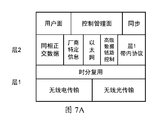
- FIG. 7A is a schematic diagram of a wireless CPRI protocol architecture according to an embodiment of the present invention.
- FIG. 7B is a flowchart of a wireless forward link switching according to an embodiment of the present invention.
- FIG. 8 is a flowchart of a method for determining a boundary of a high altitude RRU location range according to an embodiment of the present invention
- FIG. 9 is a block diagram of a device of a high altitude device according to an embodiment of the present invention.
- FIG. 10 is a block diagram of a ground equipment apparatus according to an embodiment of the present invention.
- FIG. 11 is a flowchart of a communication control method between air and ground according to an embodiment of the present invention.
- FIG. 12 is a flowchart of a method for controlling communication between air and ground according to an embodiment of the present invention.
- an embodiment of the present invention provides a method for controlling communication between air and ground.
- the method is applied to a layered network composed of a terrestrial network and at least one layer of air network, and the method includes:
- the ground device receives location information of the high altitude device sent by the upper air device; the ground device is located in the terrestrial network, and the high altitude device is located in the air network and covers the ground device;
- S120 Determine beam direction and beamwidth information of the ground device to the upper air device according to location information of the ground device and location information of the upper air device.
- the beam width information is sent to the high-altitude device in the beam direction.
- the beam width information is used to adjust a location information sending period of the high-altitude device.
- the method further includes:
- the ground device obtains a maximum moving speed of the high altitude device.
- step S111 the method specifically includes:
- the average rate over the period of time during which the average rate value is greatest is taken as the maximum rate of movement during one or more flight periods of the upper-air equipment.
- step S112 specifically:
- a boundary of a range of locations of the upper-air device is calculated based on the maximum movement rate, a maximum frequency offset allowed by a wireless link between the ground device and the upper-air device, and a wavelength of a beam.
- the step S120 determining the beam direction and beam width information of the high-altitude device according to the location information of the ground device and the location information of the upper-air device, including:
- S1201 Calculate a center position coordinate of a moving track of the high-altitude device according to the location information of the upper-air device;
- S1202 Calculate the beam direction and the beam width information according to a center position coordinate of the moving track and position information of the ground device.
- step S1202 calculating the beam direction and the beam width information according to the center position coordinate of the moving track and the position information of the ground device, including:
- S12021 Calculate a distance between the ground device and a center position of the moving track according to the center position coordinate of the moving track and the position information of the ground device;
- the step S120: the determining the beam direction and the beam width information of the high-altitude device according to the location information of the ground device and the location information of the upper-air device may include:
- the above ground device is a BBU, a base station or a cloud baseband processing unit; the cloud baseband processing unit comprises a plurality of BBUs; and the high altitude device is an RRU, a repeater or an antenna.
- the cloud baseband processing unit includes a plurality of BBUs, and when the upper air device is an RRU, as shown by a broken line in FIG.
- the ground device measures a wireless preamble link quality;
- the wireless front transmission link is a wireless communication link between the ground device and the upper air device;
- S150 Determine, according to the quality of the link, whether a handover of a wireless forward transmission link interface is required.
- the handover control information is sent to the high-altitude device to control the handover of the transmission interface by the wireless forward transmission link.
- step S150 determining, according to the link quality, whether a wireless forward link switching is required, including:
- the ground device compares the quality of the wireless forward transmission link with a threshold.
- S160 when it is determined that the handover needs to be performed, sending the handover control information to the high-altitude device, and controlling the wireless front-end link to perform the handover, including:
- the ground device when it is determined that the wireless optical transmission interface is used for wireless forward communication with the high-altitude device, the ground device sends switching control information to the high-altitude device, indicating that the high-altitude device uses the wireless optical transmission interface to perform wireless forward communication. ;
- the ground device sends handover control information to the high-altitude device, instructing the high-altitude device to perform wireless pre-communication communication by using a radio transmission interface.
- an embodiment of the present invention provides a method for controlling communication between air and ground.
- the method is applied to a layered network composed of a terrestrial network and at least one layer of air network, and the method includes:
- the high-altitude device periodically acquires its own location information.
- S220 Send the location information of the location to the ground device;
- the ground device is located in a terrestrial network, where the upper-air device is located in the air network, and covers the ground device;
- S230 Receive beamwidth information sent by the ground device, where the beamwidth information is calculated by the ground device according to the received location information of the upper-air device and the location information of the ground device itself.
- S220 before sending the location information of the location to the ground device, the method further includes:
- S220 transmitting the location information of the self to the ground device, specifically:
- the location information of the self is transmitted to the ground device in the beam direction.
- step S240 determining beam direction and beam width information to the ground device according to location information of the ground device and location information of the upper air device, including:
- step S242 includes:
- S2424 Calculating the beam width information according to a distance between the ground device and a center position of the moving track, a first preset value, a center position coordinate of the moving track, and position information of the ground device, where The first preset value is greater than or equal to a radius of the moving track.
- step S240 determining beam direction and beam width information according to the location information of the ground device and the location information of the upper air device, including:
- S2401 Calculate a radius of the moving track according to the altitude device location information
- S2402 Calculate a distance between the ground device and the upper air device according to location information of the ground device and location information of the upper air device;
- the beam width information is calculated according to the distance between the ground device and the upper-air device, the second preset value, the location information of the upper-air device, and the location information of the ground device, where The second preset value is greater than zero and less than or equal to the radius of the movement trajectory.
- the method further includes:
- the embodiment of the present invention separates the upper-air device from the ground device by using the above technical solution, and determines the beam direction according to the position information of the upper-air device or the ground device, and transmits the beam width information in the beam direction; and the beam width information is used.
- the position information transmission period of the high-altitude device is adjusted, and the wider the beam width indicated by the beam width information, the longer the transmission period of the own position information is. In this way, the air interface interaction information of the ground equipment and the upper air equipment can be reduced, and the ground equipment does not need to adjust the beam direction in real time, reduce the power consumption of the ground equipment, and improve the antenna gain of the ground equipment.
- the Radio Access Network is an important asset for mobile operators to survive, providing users with 7x24 hours of uninterrupted, high-quality data services.
- a conventional radio access network has the following features: First, each base station is connected to a fixed number of sector antennas and covers a small area, and each base station can only process and receive signals from the local cell; second, the capacity of the system is interference. Limitation, it is difficult to increase spectrum efficiency by working independently of each base station; these features bring the following challenges: A large number of base stations means high construction investment, site matching, site rental and maintenance costs, and building more base stations means More capital expenditures and operating expenses. In addition, the actual utilization rate of existing base stations is still very low, and the average load of the network is generally far lower than the busy hour load, and different base stations cannot share processing capability, and it is difficult to improve spectrum efficiency.
- the C-RAN is a cooperative wireless network composed of a cloud baseband processing unit, an RRU, and an antenna, wherein the cloud baseband processing unit includes a plurality of BBUs.
- the essence is to reduce the number of base station rooms, reduce energy consumption, adopt collaboration and virtualization technologies, realize resource sharing and dynamic scheduling, and improve spectrum efficiency to achieve low cost, high bandwidth and flexible operation.
- the power consumption and volumetric weight of the cloud baseband processing unit will be greatly increased compared with the traditional distributed base station, and it is difficult to carry it into the air through the high-altitude platform.
- the high-altitude platform is used to bring the lightweight front-end equipment into the air, which can be effectively combined with the C-RAN architecture.
- Powered high-altitude platforms (such as airships, drones, etc.) carry lightweight front-end platform equipment into the air to achieve airborne dwelling, that is, fly within a certain range.
- the ground equipment includes ground heavyweight processing platform equipment and antennas, wherein the antennas are used for wireless communication between the ground heavyweight processing platform equipment and the lightweight front end platform equipment.
- Lightweight front-end platform devices can be RRUs, repeaters or reflective antennas.
- the ground heavyweight processing platform device can be a BBU, a cloud baseband processing unit, and a base station.
- the embodiment of the present invention separates the upper-air device from the ground device by using the above technical solution, and determines the beam direction according to the position information of the upper-air device or the ground device, and transmits the beam width information in the beam direction; and the beam width information is used.
- the position information transmission period of the high-altitude device is adjusted, and the wider the beam width indicated by the beam width information, the longer the transmission period of the own position information is. In this way, the air interface interaction information of the ground equipment and the upper air equipment can be reduced, and the ground equipment does not need to adjust the beam direction in real time, reduce the power consumption of the ground equipment, and improve the antenna gain of the ground equipment.
- the following describes the high-altitude RRU and the ground BBU as an example.
- FIG. 1A is a schematic diagram of a distributed high-altitude platform communication system according to an embodiment of the present invention.
- the positioning system includes multiple BBUs (BaseBand Units) 102A to 102B and multiple RRUs (Remote Radio).
- Units, radio remote units 104A to 104F, the baseband processing units 102A to 102B are BBUs deployed on the ground, configured to be powered by the ground power system, and the radio remote units 104A to 104F are high altitude RRUs deployed in the stratosphere via the aerial platform. , configured to be powered by a high-altitude solar power system.
- the high altitude RRUs 104A through 104F can generally be configured to operate at altitudes between 18 and 25 km in height (other heights are also possible).
- This height range may be advantageous for several reasons.
- this layer of the stratosphere generally has a small wind speed (for example, a wind speed between 5 and 40 m/s) and a relatively small turbulence.
- the height above 18 km usually exceeds the maximum height specified by commercial aircraft. Therefore, when the high-altitude platform is deployed between 18km and 25km, it will not cause too much interference to commercial aircraft.
- the upper-air RRUs 104A-104F are configured to communicate with one another via a free-space link 106.
- the free space link 106 includes at least one of a free space optical link or a microwave link.
- a given high altitude RRU 104A-104F may use a laser to transmit optical signals to communicate with other upper-air RRUs 104A-104F, other types of free-space optical communication are possible.
- a given high altitude RRU 104A-104F may also use millimeter waves to transmit electromagnetic wave signals to communicate with other high altitude RRUs 104A-104F, other types of microwave communications are possible.
- a given high altitude RRU 104A-104F can be configured to communicate with other upper-air RRUs 104A-104F using a wireless CPRI protocol or a proprietary wireless forward protocol developed for high-altitude-high altitude.
- the upper-air RRUs 104A-104F are configured to communicate with the terrestrial BBUs 102A-102B via the free-space link 108.
- the free space link 108 includes at least one of a free space optical link or a microwave link.
- a given high altitude RRU 104A-104F may use a laser to transmit optical signals to communicate with terrestrial BBUs 102A-102B, other types of free-space optical communication are possible.
- a given high altitude RRU 104A-104F may also use millimeter waves to transmit electromagnetic wave signals to communicate with terrestrial BBUs 102A-102B, other types of microwave communications are possible.
- a given high altitude RRU 104A-104F can be configured to communicate with terrestrial BBUs 102A-102B using a wireless CPRI protocol or a proprietary wireless forward protocol developed for high-altitude-ground.
- the upper-air RRUs 104A to 104F are configured to include at least one of the free space link 106 or the free space link 108.
- a plurality of given high altitude RRUs 104A through 104F are configured to communicate with a given terrestrial BBU 102A through 102B via a free space link 108 to form a star network structure, such as Figure 1B shows.
- high altitude RRU 104A is configured to communicate with terrestrial BBU 102A via free space link 108
- high altitude RRU 104C is configured to communicate with terrestrial BBU 102A via free space link 108
- high altitude RRU 104D is configured to communicate via free space link 108
- the high altitude RRU 104A, the high altitude RRU 104C, the upper altitude RRU 104D and the ground BBU 102A form a star network structure.
- a given high altitude RRU is configured to communicate with a given terrestrial BBU 102A through 102B via a free space link 108
- a plurality of given The high altitude RRUs are configured to communicate with one another via a free space link 106 to form a chained network structure, as shown in Figure 1C.
- the upper-air RRU 104E is configured to communicate with the terrestrial BBU 102B via a free-space link 108
- the high-altitude RRU 104D is configured to communicate with the upper-space RRU 104E
- the high-altitude RRU 104D, the upper-air RRU 104E, and the ground BBU 102B form a chain Type network structure.
- a tree network structure can also be formed, as shown in FIG. 1D.
- the upper-air RRU 104E is configured to communicate with the ground BBU 102B via a free-space link 108
- the high-altitude RRU 104D is configured to communicate with the upper-space RRU 104E
- the upper-air RRU 104F is configured as a free-space link 106 with high altitude RRU 104E communication
- high altitude RRU 104D, high altitude RRU 104E, high altitude RRU 104F, and terrestrial BBU 102B form a tree network structure.
- two given high altitude RRUs are configured to communicate with a given terrestrial BBU 102A through 102B via a free space link 108
- a plurality of given The high altitude RRUs are configured to communicate with one another via a free space link 106 to form a ring network structure, as shown in FIG. 1E.
- high altitude RRU 104A is configured to communicate with terrestrial BBU 102A via free space link 108
- high altitude RRU 104C is configured to communicate with terrestrial BBU 102A via free space link 108
- high altitude RRU 104B is configured as free space link 106 with
- the upper-air RRU 104A and the upper-air RRU 104C communicate, and the upper-altitude RRU 104AD, the upper-altitude RRU 104B, the upper-altitude RRU 104C, and the terrestrial BBU 102A form a ring-shaped network structure.
- FIG. 2 is a flowchart of a communication method according to an embodiment of the present invention. Referring to FIG. 2, the method includes:
- the high altitude RRU acquires and stores its own location information and posture information, performs beam steering, and transmits location information to the ground BBU.
- the high altitude RRU is configured to periodically acquire its own location information.
- the location information is three-dimensional coordinate information (x, y, z).
- the specific method for obtaining the method is not limited in this embodiment of the present invention.
- the high-altitude RRU is not fixed at a certain position at a high altitude, but is constantly moving, flying roughly along the trajectory of the radius R.
- N (N ⁇ 3) pieces of position information are acquired, position information is stored, and flight trajectories are calculated.
- the method of obtaining the flight path can be:
- the center point (x 0 , y 0 , z 0 ) of the flight trajectory is calculated according to the following formula 1.
- (x i , y i , z i ) represents the acquired i-th position information, and represents multiplication
- the radius R of the flight trajectory is calculated according to the following formula 2.
- the location of the ground BBU is fixed, and the location information (x b , y b , z b ) is known to the high altitude RRU, and may be pre-stored in the high altitude RRU.
- the initial beam steering of the high-altitude RRU to the terrestrial BBU can be divided into the following three cases:
- the high-altitude RRU obtains the beam direction and the beam width according to the center point, the radius and the position information of the flight trajectory, and can be divided into the following two cases:
- the beam coverage may cover only the terrestrial BBU, and a higher antenna gain may be obtained, but the high-altitude RRU is required to frequently transmit the location information.
- the method for obtaining a beam direction may be:
- the position of the high altitude RRU is The high altitude RRU can calculate the distance between the ground BBU and the upper altitude RRU according to the following formula 3. Where (x B , y B , z B ) is the location of the ground BBU.
- the high altitude RRU can calculate the beam horizontal direction angle ⁇ and the vertical direction angle according to the following formula 4.
- the beam width is calculated, wherein the beam width is determined by the horizontal lobe angle ⁇ and the vertical lobe angle ⁇ .
- the method for acquiring the beam horizontal lobe angle can be:
- the high altitude RRU can calculate the beam horizontal lobe angle ⁇ according to Equation 5 below.
- L 2 is a second preset value, (0 ⁇ L 2 ⁇ R, where R is the radius of the flight trajectory). It should be noted that the terrestrial BBU device includes an antenna system, and L 2 may be the size of the ground BBU, the size of the antenna system, or a value larger than the size of the ground BBU.
- the method for obtaining the vertical lobe angle of the beam may be:
- the values of the beam vertical lobe angle ⁇ are different at different positions of the high altitude RRU.
- the high altitude RRU can calculate the beam vertical lobe angle ⁇ according to Equation 6 below.
- the high-altitude RRU needs the beam width to include the flight range of the high-altitude RRU, so that the high-altitude RRU is at any point on the flight path, and the beam direction and beam width do not need to be adjusted.
- the high altitude RRU can avoid frequent control of the beam direction and reduce the power consumption of the high altitude RRU, but will reduce the antenna gain.
- the method for obtaining the beam direction may be:
- the high altitude RRU can calculate the distance L between the ground BBU and the center point of the flight trajectory according to the following formula 7, where (x B , y B , z B ) is the position of the ground BBU, (x 0 , y 0 , z 0 ) The position of the center point of the flight path.
- the high altitude RRU can calculate the beam horizontal direction angle ⁇ and the vertical direction angle according to the following formula 8.
- the beam width is calculated, wherein the beam width is determined by the horizontal lobe angle ⁇ and the vertical lobe angle ⁇ .
- the method for obtaining the beam horizontal lobe angle can be:
- the high altitude RRU can calculate the beam horizontal lobe angle ⁇ according to Equation 9 below.
- L 1 is the first preset value, (L 1 ⁇ R, where R is the radius of the flight trajectory). It should be noted that L 1 may be a radius of a flight trajectory or a value larger than a radius of a flight trajectory.
- the method for obtaining the vertical lobe angle of the beam can be:
- the high altitude RRU can calculate the beam vertical lobe angle ⁇ according to the following formula 10.
- the high altitude RRU can control the signal beam to the ground BBU.
- the high altitude RRU sends location information to the terrestrial BBU. It should be noted that the timing of sending the location information to the high-altitude RRU may be sent to the ground BBU after acquiring one location information, or may be sent to the ground BBU after acquiring multiple location information, or may be needed when needed. Sended to the ground BBU.
- the upper-air device may not calculate the beam direction and the beam width, and preset the beam direction and beam width to provide a wide coverage. This can reduce the amount of computation of the upper-air equipment, but the antenna gain is low.
- the beam direction of the high-altitude device can be perpendicular to the ground, and the beam width can be 180 degrees, which can ensure that the ground device can receive information of the upper-air device within a preset distance. It should be noted that other beam directions and beam angles are also possible.
- the air RRU is affected by turbulence, and bumping and jitter will cause the beam direction to change.
- the high altitude RRU is configured to periodically acquire its own pose information.
- the high altitude RRU compensates the beam horizontal direction angle ⁇ and the vertical direction angle according to the attitude information. Align the beam direction with the ground BBU.
- the posture information may be polar coordinate information or other information.
- the specific calculation method is not specifically limited in the embodiment of the present invention.
- the ground BBU receives and stores the location information of the high altitude RRU, performs beam steering, and sends beamwidth information to the upper air RRU.
- the ground BBU obtains the beam direction and the beam width according to the center point, the radius and the position information of the high-altitude RRU flight trajectory, and can be divided into the following two cases:
- the method for obtaining a beam direction may be:
- the position of the high altitude RRU is Send location information to the ground BBU.
- the ground BBU period receives and stores the location information of the high altitude RRU. It should be noted that after the location information is acquired by the high-altitude RRU, it is sent to the ground BBU, and the interval between the time when the ground BBU receives the location information and the time when the high-altitude RRU acquires the location information is small, and the moving distance of the high-altitude RRU is also very high in the interval. Small, can be approximated as no movement.
- the distance between the high altitude RRU and the ground BBU is 100 km
- the signal transmission delay value is 0.33 ms
- the signal processing delay value can be 1 ms
- the interval value is 1.33 ms
- the high altitude RRU speed value can be 20 m/s.
- the moving distance value in this interval is 26.6 mm, which is approximately considered to be no movement.
- the ground BBU can calculate the distance between the ground BBU and the high altitude RRU according to the above formula (3).
- (x B , y B , z B ) is the location of the ground BBU.
- the ground BBU can calculate the beam horizontal direction angle ⁇ and the vertical direction angle according to the above formula (4).
- the beam width is calculated, wherein the beam width is determined by the horizontal lobe angle ⁇ and the vertical lobe angle ⁇ .
- the method for acquiring the horizontal lobe angle of the beam may be:
- the ground BBU can calculate the beam horizontal lobe angle ⁇ according to the above formula (5).
- the high-altitude RRU device includes an antenna system
- L 2 may be a size of an aerial RRU, a size of the antenna system, or a value larger than a high-altitude RRU.
- the method for obtaining the vertical lobe angle of the beam may be:
- the values of the beam vertical lobe angle ⁇ are different at different positions of the high altitude RRU.
- the ground BBU can calculate the beam vertical lobe angle ⁇ according to the above formula (6).
- the terrestrial BBU can avoid frequent control of the beam direction, and the high-altitude RRU can also avoid sending location information to the ground BBU frequently, and only send to the high-altitude RRU under certain conditions. location information.
- the method for obtaining the beam direction may be:
- the ground BBU receives and stores N (N ⁇ 3) pieces of position information.
- the center point (x 0 , y 0 , z 0 ) and the radius R of the flight trajectory of the high altitude RRU are calculated according to the above formulas (1) and (2). It should be noted that the center point and radius information of the flight trajectory can also be calculated by the high altitude RRU and sent to the ground BBU.
- the ground BBU can calculate the distance L between the ground BBU and the center point of the flight trajectory according to the above formula (7), where (x B , y B , z B ) is the position of the ground BBU.
- the ground BBU can calculate the beam horizontal direction angle ⁇ and the vertical direction angle according to the above formula (8).
- the beam width is calculated, wherein the beam width is determined by the horizontal lobe angle ⁇ and the vertical lobe angle ⁇ .
- the method for acquiring the horizontal lobe angle of the beam may be:
- the ground BBU can calculate the beam horizontal lobe angle ⁇ according to the above formula (9).
- the method for acquiring the vertical lobe angle of the beam may be:
- the ground BBU can calculate the beam vertical lobe angle ⁇ according to the above formula (10).
- the terrestrial BBU can control the signal beam to the high altitude RRU.
- the ground BBU sends the beamwidth information to the high-altitude RRU.
- the beamwidth information may be an angle value, or may be a point coverage information.
- a redundant area is added to the beam coverage range to prevent the high-altitude RRU from deviating from the flight path due to environmental factors such as turbulence, thereby causing the free space link between the high-altitude RRU and the ground BBU to be interrupted.
- ⁇ ' n 2 ⁇ . Where n 1 and n 2 are redundancy factors, and n 1 >1 and n 2 >1.
- the redundancy factor may be pre-configured by the ground BBU or may be reconfigured according to the situation.
- the high-altitude RRU cycle acquires its own position information to determine whether it deviates from the trajectory. Specifically, at time t 2 , the position of the high altitude RRU itself The center point of the flight trajectory (x 0 , y 0 , z 0 ), and the distance value between the current position and the center point is calculated according to the following formula 11.
- the method for controlling the beam direction may be:
- the high-altitude RRU compares the distance value l with the threshold T. If the distance value l is less than or equal to the threshold T, it indicates that there is a certain distance from the boundary of the high-altitude RRU distance coverage, and no operation is performed; if the distance value l is greater than the threshold T, the altitude RRU distance is indicated. The boundaries of the coverage are very close and may fly out of coverage.
- the high altitude RRU sends the location information of the moment to the ground BBU. It should be noted that the threshold may be pre-configured by the ground BBU or may be reconfigured according to the situation.
- the ground BBU receives the position information, and calculates the distance value l between the current position of the high altitude RRU and the center point according to the above formula (11). It should be noted that the distance value may also be sent by the high altitude RRU to the ground BBU.
- the position offset value is calculated according to the following formula 12. Where R is the radius of the flight path.
- the position of the new flight path center point is calculated according to the following formula 13.
- the ground BBU calculates a new beam direction based on the position of the new center point (x' 0 , y' 0 , z' 0 ), and controls the signal beam to the high altitude RRU.
- the method for calculating the beam direction is the same as the method for calculating the beam direction in step 202, and details are not described herein again.
- the high altitude RRU After a period of time, at time t 3 , the position of the high altitude RRU itself If the distance value l is less than or equal to the threshold T, the high altitude RRU transmits the location information of the moment to the ground BBU. After receiving the location information, the ground BBU controls the signal beam to the high altitude RRU according to the original beam direction calculated from the original center point position (x 0 , y 0 , z 0 ).
- the high altitude RRU receives and stores beamwidth information, and adjusts a period of sending location information to the terrestrial BBU.
- the high-altitude RRU judges, according to the beam width information, that the signal beam of the terrestrial BBU covers the moving range of the upper-altitude RRU, or covers only the upper-altitude RRU.
- the coverage of the beam is different, and the period in which the high-altitude RRU sends the location information to the terrestrial BBU is also different.
- FIG. 6 is a process of determining a period of transmitting location information by a high altitude RRU, including the following steps:
- the high altitude RRU receives and stores beamwidth information.
- the beam width information may be an angle value, or may be a point coverage information.
- the high altitude RRU determines, according to the beam width information, whether the beam only covers the high altitude RRU, and if yes, executes 603, and if not, executes 604.
- the high-altitude RRU calculates the beam coverage according to the angle value, and determines whether it is a point coverage or an area coverage.
- the method for calculating the beam coverage is the same as the method for calculating the beam width in step 202. Let me repeat.
- the high altitude RRU period sends location information to the ground BBU.
- the location information is sent to the ground BBU.
- the ground BBU receives the location information, calculates the beam direction, and controls the beam alignment to the high altitude RRU to obtain a high antenna gain.
- the high-altitude RRU periodically sends the location information to the terrestrial BBU, which increases the interaction information between the high-altitude RRU and the terrestrial BBU.
- the high altitude RRU sends location information to the terrestrial BBU under certain circumstances.
- the high altitude RRU calculates a position offset value based on the location information, determines whether it is greater than a threshold, and if so, transmits the current location information to the terrestrial BBU.
- the ground BBU may not require frequent control of the beam direction.
- the ground BBU calculates the link quality, sends the handover control information to the upper air RRU, and adaptively switches the wireless front transmission link.
- the terrestrial BBU can include free-space optical links and microwave links.
- the high altitude RRU can include free space optical links and microwave links.
- the high-altitude RRU can communicate with the terrestrial BBU using the wireless CPRI protocol, or can communicate with other high-altitude RRUs using the wireless CPRI protocol.
- the wireless CPRI protocol includes two physical interfaces: a radio transmission port and a wireless optical transmission port. Specifically, the radio transmission port transmits a microwave signal (such as a millimeter wave), and the wireless optical transmission port transmits an optical signal (such as a laser).
- the link between the ground BBU and the upper-air RRU, the link between the upper-altitude RRU and the upper-altitude RRU may be referred to as a wireless forward transmission link.
- the wireless front-end link Several weather factors are detrimental to the wireless front-end link, including factors such as rain, snow, fog, haze, and dust.
- the wavelength of the electromagnetic wave is close to or even smaller than the size of the airborne particles, a large absorption attenuation is formed.
- the laser communication frequency (about 200 to 300 THz) is much higher than the millimeter wave (30 to 300 GHz), it is more affected by environmental factors.
- Laser communication has a higher transmission rate relative to millimeter waves. If a given transmission rate is to be obtained, fewer laser communication links are required than millimeter wave links.
- the laser communication transmission rate can be 10 Gbps, and the millimeter wave transmission rate can be 2.5 Gbps.
- the millimeter wave link requires four.
- the power consumption of the millimeter wave link is higher than the power consumption of the laser link.
- the initial state of the wireless forwarding link may be a radio transmission port or a wireless optical transmission port.
- FIG. 7B is a process of adaptive link switching, including the following steps:
- the ground BBU measures the quality of the wireless preamble link.
- the terrestrial BBU can measure the wireless preamble link quality Q f according to the error rate of the received data.
- Q f can be quantized as a specific value, 0 to 255. A larger value indicates a better link quality, and the opposite is difference.
- the quality of the wireless preamble link is also measured by other methods, which is not specifically limited in this embodiment of the present invention.
- the ground BBU determines whether to use the free space optical link according to the quality of the wireless preamble link. If yes, execute 703. If no, execute 704.
- the ground BBU compares the quality of the wireless preamble link Q f with the threshold T. If the quality of the wireless preamble link Q f is greater than the threshold T, the quality of the wireless preamble link can meet the conditions of the free space optical link, and the free space optical link is used. Wireless preamble communication; if the wireless preamble link quality Q f is less than or equal to the threshold T, it indicates that the wireless preamble link quality does not satisfy the condition of the free space optical link, and the radio link is used for wireless preamble communication. It should be noted that the threshold may be pre-configured by the ground BBU or may be reconfigured according to the situation.
- a free-space optical link is used between the ground BBU and the high-altitude RRU for wireless forward communication.
- the ground BBU sends handover control information to the upper air RRU.
- the high-altitude RRU receives the handover control information, and performs wireless pre-communication communication using a free-space optical link according to the indication in the handover control information. And send a confirmation message to the ground BBU.
- a wireless link is used between the ground BBU and the high altitude RRU for wireless forward communication.
- the ground BBU sends handover control information to the upper air RRU.
- the high altitude RRU receives the handover control information, and performs wireless forward communication using the microwave link according to the indication in the handover control information. And send a confirmation message to the ground BBU.
- the high-altitude RRU can also measure the quality of the wireless pre-transmission link, and is used for adaptive link switching between the high-altitude RRU and the upper-altitude RRU.
- the CPRI protocol includes multiple control words for synchronization and control management of the preamble link.
- the definition of the control word is as shown in Table 1:
- the vendor specific can be defined by various vendors.
- the content of the switching control information includes transmission using a radio transmission port or transmission using an optical transmission port.
- the configuration of the switching control information can be as shown in Table 2:
- Z superframe number
- X the number of basic frames in the superframe
- Y the number of bytes in each word
- the contents of other bits eg, Bit7 ⁇ Bit1 are reserved.
- the ground BBU sends the switch information to the high-altitude RRU. If the value is "0", it indicates that the radio link is used for wireless pre-communication. If the value is "1", it indicates that the free-space optical link is used for wireless pre-communication. After receiving the Switch information, the high-altitude RRU uses the corresponding link to perform wireless pre-communication and sends the same Switch information to the ground BBU to confirm.
- FIG. 8 is a flowchart of a method for determining a boundary of a high altitude RRU location range according to an embodiment of the present invention.
- the high-altitude RRU constantly moves in the stratosphere, which will generate Doppler shift, which will affect the quality of the wireless preamble link.
- the method includes:
- the ground BBU obtains a maximum moving rate of the high altitude RRU.
- the high-altitude RRU is flying along the flight path, and there will be a downwind and an upwind. When the wind is down, the speed is high, and when the wind is against the wind, the speed is small. The moving speed of the high altitude RRU is not constant.
- the high altitude RRU cycle acquires its own location and sends location information to the terrestrial BBU.
- the ground BBU receives location information.
- the position of the high altitude RRU itself At time t 5 , the position of the high altitude RRU itself
- the average rate during this time is calculated according to Equation 14 below.
- the ground BBU calculates a boundary of a high altitude RRU location range.
- the maximum frequency offset allowed by the wireless forward transmission link is ⁇ f max
- the ground BBU position is (x B , y B , z B )
- the high altitude RRU initial position is (x R , y R , z R ).
- the boundary of the position range of the high altitude RRU can be calculated according to the following formula 15.
- v max is the maximum moving rate value
- ⁇ is the wavelength
- ⁇ is the angle between the moving direction and the incident wave direction
- L is the distance between the ground BBU and the high altitude RRU
- H is the vertical between the ground BBU and the high altitude RRU Height difference.
- the ground BBU determines an initial position of the high altitude RRU.
- the ground BBU can determine the initial position of the high altitude RRU according to the boundary of the high altitude RRU location range, and send the location information to the upper air RRU. After receiving the location information, the high-altitude RRU can move to the specified location according to the location information.
- the center of the flight path of the high altitude RRU is directly above the ground BBU (or, the high altitude RRU is directly above the ground BBU), the Doppler shift is zero, and the position of the high altitude RRU is optimal.
- the ground BBU can also re-plan the network and update the initial position of the high-altitude RRU according to the requirements.
- the embodiment of the present invention separates the upper-air device from the ground device by using the above technical solution, and determines the beam direction according to the position information of the upper-air device or the ground device, and transmits the beam width information in the beam direction; and the beam width information is used.
- the position information transmission period of the high-altitude device is adjusted, and the wider the beam width indicated by the beam width information, the longer the transmission period of the own position information is. In this way, the air interface interaction information of the ground equipment and the upper air equipment can be reduced, and the ground equipment does not need to adjust the beam direction in real time, reduce the power consumption of the ground equipment, and improve the antenna gain of the ground equipment.
- FIG. 9 is a block diagram of an apparatus for a high altitude device according to an embodiment of the present invention.
- the high altitude device includes an information obtaining module 901, a sending module 902, a receiving module 903, and an adjusting module 904.
- the high-altitude device may further include a beam direction control module 905 and a switching module 906. It should be noted that the two modules are not required. The individual modules are described in detail below.
- the information obtaining module 901 is configured to periodically acquire location information and posture information of the upper-air device device during the beam control process.
- the information acquisition module 901 may include, for example, one or more of a Global Positioning System (GPS), an inertial navigation system, various motion sensors (eg, accelerometers, magnetometers, gyroscopes, etc.).
- GPS Global Positioning System
- inertial navigation system various motion sensors (eg, accelerometers, magnetometers, gyroscopes, etc.).
- a sending module 902 configured to send the location information of the location to the ground device;
- the groundless device is located in a terrestrial network, where the upper air device is located in the air network, and covers the ground device;
- the sending module 902 can also be used to send the location information of the upper air device to the ground device and other high altitude devices.
- the sending module is further configured to send the handover control information to the ground device during the adaptive handover link process.
- the sending module is further configured to send the moving rate information to the ground device during determining the initial position of the high altitude device.
- the sending module is further configured to send a center position coordinate of the new moving track to the ground device during the beam steering process.
- the receiving module 903 is configured to receive beamwidth information sent by the ground device during the beam steering process.
- the beam width information is calculated by the ground device according to the location information and the location information of the ground device itself;
- the receiving module 903 is further configured to receive the handover control information sent by the ground device during the adaptive handover link process.
- the receiving module 903 is further configured to receive initial location information sent by the ground device during determining the initial location of the high altitude device.
- the receiving module 903 is further configured to receive a track deviation threshold sent by the ground device during the beam control process.
- the adjustment module 904 is configured to adjust, according to the beam width information received by the receiving module 903, a transmission period of the self location information, where the beamwidth information indicates that the beamwidth is wider, the location information of the location The longer the transmission cycle. .
- the beam direction control module 905 is configured to calculate beam direction and beam width information according to the position information of the ground device and the position information of the ground device during the beam control process.
- the beam direction control module 905 may include different units according to different situations.
- the beam direction control module 905 includes:
- a radius calculation module 90510 configured to calculate a radius of the movement track according to the altitude device location information
- the radius calculation module 90510 can obtain the radius R of the flight path of the aerial equipment according to the above formula (2);
- a distance calculating module 90520 configured to calculate a distance between the ground device and the upper air device according to the location information of the ground device and the location information of the upper air device;
- the distance calculation module 90520 can calculate the distance between the ground device and the upper air device according to the above formula (3).
- the beam direction calculation module 90530 is configured to calculate the beam direction according to the distance between the ground device and the upper-air device calculated by the distance calculation module 90520, the location information of the upper-air device, and the location information of the ground device. ;
- the beam direction calculation module 90530 can calculate the beam horizontal direction angle ⁇ and the vertical direction angle according to the above formula (4).
- a beam width information calculation module 90540 configured to calculate a distance between the ground device and the upper-air device calculated according to the distance calculation module 90520, a second preset value, location information of the upper-air device, and a location of the ground device And calculating the beam width information, wherein the second preset value is greater than zero and less than or equal to a radius of the moving track.
- the beam width information calculation module 90540 can calculate the beam horizontal lobe angle ⁇ according to the above formula (5).
- the beam horizontal lobe angle ⁇ is calculated according to the above formula (6).
- the beam direction control module includes:
- a track center coordinate calculation unit 9051 configured to calculate a center position coordinate of a moving track of the upper air device according to position information of the upper air device;
- the center position coordinates (x 0 , y 0 , z 0 ) of the movement trajectory of the aerial equipment can be calculated according to the above formula (1);
- the direction and width calculation unit 9052 calculates the beam direction and the beam width information based on the center position coordinates of the movement trajectory calculated by the trajectory center coordinate calculation unit 9051 and the position information of the ground device.
- the direction direction and width calculation unit 9052 specifically includes:
- a radius calculation subunit 90521 configured to calculate a radius R of a flight path of the upper air equipment according to position information of the upper air equipment (for example, multiple positions of the aerial equipment);
- a distance calculation subunit 90522 configured to calculate a center position coordinate of the movement trajectory calculated by the trajectory center coordinate calculation unit 9051 and position information of the ground device, and calculate a central position between the ground device and the movement trajectory distance;
- the distance calculation subunit 90522 calculates the distance L between the ground position coordinates of the ground device and the flight trajectory according to the above formula (7);
- a beam direction calculation subunit 90523 configured to calculate the beam according to the distance calculated by the distance calculation subunit 90522, the center position coordinate of the movement trajectory calculated by the trajectory center coordinate calculation unit 9051, and the position information of the ground device. direction;
- the beam direction calculation sub-unit 90523 can calculate the beam horizontal direction angle ⁇ and the vertical direction angle according to the above formula (8).
- a beam width information calculation subunit 90523 configured to calculate a distance calculated by the distance calculation subunit 90522, a first preset value, a center position coordinate of the movement trajectory calculated by the trajectory center coordinate calculation unit 9051, and the ground device
- the position information calculates the beam width information, wherein the first preset value is greater than or equal to a radius of the moving track.
- the beam width information calculation sub-unit 90523 can calculate the beam horizontal lobe angle ⁇ according to the above formula (9).
- the beam horizontal lobe angle ⁇ is calculated according to the above formula (10).
- the beam direction control module 905 is further configured to calculate a center position coordinate of the new moving track according to the off-board flight trajectory information in the beam steering process.
- the beam direction control module 905 is further configured to compensate a beam direction according to the foregoing posture information in a beam steering process.
- the foregoing high-altitude device may be an RRU, and the foregoing ground device may be a BBU.
- the cloud baseband processing unit includes multiple BBUs
- the receiving module is further configured to receive a handover control command of the ground device.
- the high altitude device further includes:
- the switching module 906 is configured to: after the receiving module receives the switching control command of the ground device, switch the corresponding interface to perform wireless pre-communication communication according to the information carried by the control command.
- the embodiment of the present invention separates the upper-air device from the ground device by using the above technical solution, and determines the beam direction according to the position information of the upper-air device or the ground device, and transmits the beam width information in the beam direction; and the beam width information is used.
- the position information transmission period of the high-altitude device is adjusted, and the wider the beam width indicated by the beam width information, the longer the transmission period of the own position information is. In this way, the air interface interaction information of the ground equipment and the upper air equipment can be reduced, and the ground equipment does not need to adjust the beam direction in real time, reduce the power consumption of the ground equipment, and improve the antenna gain of the ground equipment.
- FIG. 10 is a block diagram of a ground equipment apparatus according to an embodiment of the present invention.
- the apparatus includes a transmitting module 1001, a receiving module 1002, and a control module 1003.
- the rate obtaining module 1004, the calculating module 1005, the mobile control module 1006, the measuring module 1007, the determining module 1008, and the switching indicating module 1009 may be further included.
- these modules are not required.
- the receiving module 1002 is configured to receive location information sent by the upper air device during the beam steering process.
- the receiving module 1002 is further configured to receive the handover control information sent by the upper air device during the adaptive handover link process.
- the receiving module 1002 is further configured to receive the mobile rate information sent by the upper air device in determining the initial position of the high altitude device.
- the receiving module 1002 is further configured to receive, in a beam control process, a center position coordinate of the high-altitude device to send a new moving track.
- the control module 1003 is configured to calculate beam direction and beam width information according to the location information of the ground device itself and the location information of the upper air device received by the receiving module 1002 in the beam control process.
- the sending module 1001 is configured to send beam width information to the high-altitude device in a beam direction determined by the control module 1003, where the beam width information is used to adjust a location information sending period of the high-altitude device
- the sending module 1001 is further configured to send the handover control information to the upper air device during the adaptive handover link process.
- the sending module 1001 is further configured to send initial location information to the upper air device during determining the initial position of the upper air device.
- the sending module 1001 is further configured to send a track deviation threshold to the upper air equipment during the beam steering process.
- the control module 1003 includes:
- a radius calculation module 10031 configured to calculate a radius of the movement track according to the altitude device location information
- the radius calculation module 10031 can obtain the radius R of the flight path of the aerial equipment according to the above formula (2);
- the distance calculation module 10032 is configured to calculate a distance between the ground device and the upper air device according to the location information of the ground device and the location information of the upper air device;
- the distance calculation module 10032 can calculate the distance between the ground device and the upper air device according to the above formula (3).
- the beam direction calculation module 10033 is configured to calculate the beam direction according to the distance between the ground device and the upper-air device calculated by the distance calculation module 10032, the location information of the upper-air device, and the location information of the ground device. ;
- the beam direction calculation module 10033 can calculate the beam horizontal direction angle ⁇ and the vertical direction angle according to the above formula (4).
- a beam width information calculation module 10034 configured to calculate, according to the distance calculation module 10032, a distance between the ground device and the upper-air device, a second preset value, location information of the upper-air device, and a location of the ground device And calculating the beam width information, wherein the second preset value is greater than zero and less than or equal to a radius of the moving track.
- the beam width information calculation module 10034 can calculate the beam horizontal lobe angle ⁇ according to the above formula (5).
- the beam horizontal lobe angle ⁇ is calculated according to the above formula (6).
- the control module 1003 includes:
- a track center coordinate calculation unit 100310 configured to calculate a center position coordinate of a moving track of the high altitude device according to position information of the upper air device;
- the track center coordinate calculation unit 100310 may calculate a center position coordinate (x 0 , y 0 , z 0 ) of the movement track of the upper-air device according to the above formula (1);
- the direction and width calculation unit 100320 calculates the beam direction and the beam width information based on the center position coordinates of the movement trajectory calculated by the trajectory center coordinate calculation unit 100310 and the position information of the ground device.
- the direction and width calculation unit 100320 specifically includes:
- a radius calculation sub-unit 100321 configured to calculate a radius R of a flight path of the upper-air device according to position information (for example, a plurality of positions) of the upper-air device;
- a distance calculation subunit 100322 configured to calculate a center position coordinate of the movement trajectory calculated by the trajectory center coordinate calculation unit 100310 and position information of the ground device, and calculate a center position between the ground device and the movement trajectory distance;
- the distance calculation subunit 100322 can calculate the distance L between the ground device and the center position coordinates of the flight trajectory according to the above formula (7);
- the beam direction calculation subunit 100323 is configured to calculate the beam according to the distance calculated by the distance calculation subunit 100322, the center position coordinate of the movement trajectory calculated by the trajectory center coordinate calculation unit 100310, and the position information of the ground device. direction;
- the beam direction calculation subunit 100323 can calculate the beam horizontal direction angle ⁇ and the vertical direction angle according to the above formula (8). Beam horizontal direction angle ⁇ and vertical direction angle After calculation, the beam direction is determined;
- a beam width information calculation subunit 100324 configured to calculate a distance 100322 calculated by the subunit according to the distance, a first preset value, a center position coordinate of the movement trajectory calculated by the trajectory center coordinate calculation unit 100310, and the ground device The position information calculates the beam width information, wherein the first preset value is greater than or equal to a radius of the moving track;
- the beam width information calculation sub-unit 100324 may calculate the beam horizontal lobe angle ⁇ according to the above formula (9).
- the beam horizontal lobe angle ⁇ is calculated according to the above formula (10), thereby obtaining beam width information.
- control module 1003 is further configured to: in the beam control process, recalculate the beam horizontal direction angle ⁇ and the vertical direction angle according to the foregoing (8) according to the central position coordinate of the receiving high-altitude device transmitting a new moving trajectory.
- the method further includes a rate obtaining module 1004, a calculating module 1005, a mobile control module 1006, a measuring module 1007, a determining module 1008, and a switching indicating module 1009, wherein the functions of the modules are as follows:
- the rate obtaining module 1004 obtains a maximum moving rate of the upper air equipment for determining the boundary of the high altitude equipment location range.
- the rate obtaining module 1004 specifically includes:
- the calculating unit 10041 is configured to calculate, according to the position information of the two different times obtained by the receiving module 1002, an average rate within a time difference of different time points; specifically, the calculating unit 10041 may calculate according to the formula (14) above. Average rate over time differences at different times;
- the rate determining unit 10042 is configured to obtain a maximum moving rate according to the plurality of average rate values during one or more flight periods.
- a calculation module 1005 configured to calculate a boundary of a location range of the upper air device according to a maximum movement rate obtained by the rate obtaining module 1004;
- the calculation module 1005 may calculate the boundary of the location range of the upper-air device according to the above formula (15).
- the mobility control module 1006 moves for controlling the upper-air device within the boundary of the location range calculated by the computing module for determining the boundary of the altitude device location range.
- the measurement module 1007 is configured to measure the quality of the wireless forward transmission link during the wireless forward transmission link handover.
- the determining module 1008 is configured to determine, according to the link quality measured by the measurement module, whether to switch the wireless forward link transmission interface during the wireless forward link switching process. Specifically include:
- the comparing unit 10081 is configured to compare the quality of the wireless preamble measured by the measurement module with a threshold
- the determining unit 10082 is configured to determine, if the wireless preamble link quality is greater than the threshold, to perform wireless preamble communication using the wireless optical transmission interface; if the wireless preamble link quality is less than the threshold, determine that the radio interface is used by the radio interface Wireless forward communication.
- the handover indication module 1009 is configured to send handover control information to the upper air interface to control the handover of the transmission interface of the wireless forward transmission link when determining that handover is required during the wireless forward transmission link handover.
- an embodiment of the present invention may further provide a distributed high-altitude device communication system, where the system includes a high-altitude front-end platform device and a ground processing platform device, where:
- the high-altitude front-end platform device includes an airborne device and a high-altitude device as described in the previous embodiments, the airborne device carrying the high-altitude device residing in the air, the airborne dwelling means moving within a certain range;
- the ground processing platform apparatus includes a ground apparatus and an antenna as described in the previous embodiments, wherein the antenna and the ground equipment cooperate to communicate with a high altitude apparatus.
- the ground device is a BBU, a base station or a cloud baseband processing unit, and the cloud baseband processing unit includes a plurality of BBUs.
- the aerial equipment is an RRU, a repeater or an antenna.
- the embodiment of the present invention separates the upper-air device from the ground device by using the above technical solution, and determines the beam direction according to the position information of the upper-air device or the ground device, and transmits the beam width information in the beam direction; and the beam width information is used.
- the position information transmission period of the high-altitude device is adjusted, and the wider the beam width indicated by the beam width information, the longer the transmission period of the own position information is. In this way, the air interface interaction information of the ground equipment and the upper air equipment can be reduced, and the ground equipment does not need to adjust the beam direction in real time, reduce the power consumption of the ground equipment, and improve the antenna gain of the ground equipment.
- a person skilled in the art may understand that all or part of the steps of implementing the above embodiments may be completed by hardware, or may be instructed by a program to execute related hardware, and the program may be stored in a computer readable storage medium.
- the storage medium mentioned may be a read only memory, a magnetic disk or an optical disk or the like.
Landscapes
- Engineering & Computer Science (AREA)
- Computer Networks & Wireless Communication (AREA)
- Signal Processing (AREA)
- Physics & Mathematics (AREA)
- Astronomy & Astrophysics (AREA)
- Aviation & Aerospace Engineering (AREA)
- General Physics & Mathematics (AREA)
- Mobile Radio Communication Systems (AREA)
Abstract
The embodiments of the invention provide a communication control method utilized in air-to-ground communication. The method is applicable to a layered network comprising a ground network and at least one layer of air networks. The method comprises: receiving, by a ground platform, location information of an air platform transmitted therefrom, wherein the ground platform is located in the ground network, and the air platform is located in the air network and covers the ground platform; determining, according to location information of the ground platform and the location information of the air platform, a direction of a beam; and transmitting, in the direction of the beam, and to the air platform, beam width information, wherein the beam width information is used to adjust a period of transmitting the location information of the air platform.
Description
本申请要求在2016年12月30日提交中国专利局、申请号为201611265870.7、申请名称为“高空通信系统、方法及装置”的中国专利申请的优先权,其全部内容通过引用结合在本申请中。The present application claims priority to Chinese Patent Application No. 201611265870.7, filed on Dec. 30, 2016, which is hereby incorporated herein in .
本发明涉及无线通信技术领域,特别涉及一种高空通信系统、方法及装置。The present invention relates to the field of wireless communication technologies, and in particular, to a high altitude communication system, method and apparatus.
国际电联(ITU)的报告显示,目前世界上仍有近2/3的人口没有联网,主要分布在偏远、人口密度低的地区。通过地面基站为这些地区进行网络覆盖,成本会非常高。利用空中平台(气球、飞艇、无人机)提供面向偏远地区的广覆盖网络是一种新的手段。通常,高空平台位于距离地面高度18~25km的平流层。平流层这一层一般具有较小的风速(例如,5到40m/s之间的风速)和相对较小的湍流。另外,18km以上的高度通常超过了商业飞机指定的最大高度。因此,当高空平台部署在18km至25km之间时,对商业飞机不会造成太大干扰。According to the report of the ITU (ITU), nearly two-thirds of the world's population is still not connected, mainly in remote and low-density areas. Network coverage for these areas through terrestrial base stations can be very costly. The use of aerial platforms (balloons, airships, drones) to provide a wide coverage network for remote areas is a new approach. Usually, the high-altitude platform is located in the stratosphere at a height of 18 to 25 km from the ground. This layer of the stratosphere generally has a small wind speed (for example, a wind speed between 5 and 40 m/s) and a relatively small turbulence. In addition, the height above 18 km usually exceeds the maximum height specified by commercial aircraft. Therefore, when the high-altitude platform is deployed between 18km and 25km, it will not cause too much interference to commercial aircraft.
在相关技术中,例如谷歌气球,高空平台携带基站(包括BBU、RRU、天线等通信设备)升到平流层,高空基站与地面核心网利用无线回传进行通信。高空平台需要对通信设备做低温、低压、低湿度及散热等保护措施,避免对设备造成影响。高空平台通过太阳电池供电。In the related art, for example, a Google balloon, a high-altitude platform carries a base station (including a communication device such as a BBU, an RRU, an antenna, etc.) to the stratosphere, and the high-altitude base station and the terrestrial core network communicate by wireless backhaul. The high-altitude platform needs to protect the communication equipment from low temperature, low voltage, low humidity and heat dissipation to avoid affecting the equipment. The aerial platform is powered by solar cells.
在实现本发明的过程中,发明人发现现有技术至少存在以下问题:In the process of implementing the present invention, the inventors have found that the prior art has at least the following problems:
高空平台的载重与平台大小、成本成正比。将基站搬移到高空平台上,基站的体积、重量、保温、散热及功耗等问题对高空平台的有效载荷和供电能力提出非常高的要求。随着未来无线接入网逐步向C-RAN(Could-Random Access Networks)演进,集中式基带处理池的设备功耗,体积重量,也会相比传统分布式基站大幅度增加。很难通过高空平台带到空中,而且现有的这种结构造成地面和高空之间空口交互信息过多,消耗功率大。The load of the high-altitude platform is proportional to the size and cost of the platform. Moving the base station to the high-altitude platform, the size, weight, insulation, heat dissipation and power consumption of the base station impose very high requirements on the payload and power supply capability of the high-altitude platform. With the evolution of the wireless access network to the C-RAN (Could-Random Access Networks) in the future, the power consumption and volumetric weight of the centralized baseband processing pool will be greatly increased compared with the traditional distributed base stations. It is difficult to bring it to the air through the high-altitude platform, and the existing structure causes excessive interaction information between the ground and the upper air, and consumes a large amount of power.
发明内容Summary of the invention
为了解决现有技术的问题,本发明实施例提供了一种高空通信系统、方法及装置。所述技术方案如下:In order to solve the problems of the prior art, embodiments of the present invention provide a high-altitude communication system, method, and apparatus. The technical solution is as follows:
一方面,本发明实施例提供一种空中和地面间的通信控制方法,所述方法应用于地面网络和至少一层空中网络组成的分层网络中,所述方法包括:In one aspect, an embodiment of the present invention provides a method for controlling communication between air and ground, the method being applied to a layered network composed of a terrestrial network and at least one layer of air network, the method comprising:
地面平台接收高空平台发送的所述高空平台的位置信息;所述无地面平台位于地面网络中,所述高空平台位于所述空中网络中,且覆盖所述地面平台;The ground platform receives location information of the high altitude platform sent by the upper air platform; the groundless platform is located in the ground network, and the high altitude platform is located in the air network and covers the ground platform;
根据地面平台的位置信息和所述高空平台的位置信息确定波束方向;Determining a beam direction according to location information of the ground platform and location information of the high altitude platform;
在所述波束方向上向所述高空平台发送波束宽度信息;所述波束宽度信息用于调整所述高空平台的位置信息发送周期。Transmitting beamwidth information to the high altitude platform in the beam direction; the beamwidth information is used to adjust a location information transmission period of the high altitude platform.
本发明实施例还包括:The embodiment of the invention further includes:
所述地面平台测量无线前传链路质量;所述无线前传链路为所述地面平台和所述高空平台之间的无线通信链路;The ground platform measures a wireless preamble link quality; the wireless preamble link is a wireless communication link between the ground platform and the upper air platform;
根据所述链路质量,判断是否需要进行无线前传链路传输接口的切换;Determining, according to the quality of the link, whether switching of the wireless forward link transmission interface is required;
当判断需要进行切换时,向所述高空平台发送切换控制信息以控制无线前传链路进行传输接口的切换。When it is determined that the handover is required, the handover control information is sent to the high altitude platform to control the wireless forward transmission link to perform the handover of the transmission interface.
本发明实施例中,所述根据所述链路质量和预定策略,判断是否需要进行无线前传链路切换,包括:In the embodiment of the present invention, the determining whether the wireless front-end link switching is required according to the link quality and the predetermined policy includes:
地面平台将所述无线前传链路质量与门限进行比较;The ground platform compares the quality of the wireless forward transmission link with a threshold;
如果所述无线前传链路质量大于所述门限,判断与所述高空平台之间使用无线光传输接口进行无线前传通信;如果所述无线前传链路质量小于所述门限,判断与所述高空平台之间使用无线电传输接口接口进行无线前传通信。If the quality of the wireless preamble link is greater than the threshold, determining to use the wireless optical transmission interface to perform wireless preamble communication with the high altitude platform; and if the quality of the wireless preamble link is less than the threshold, determining the high altitude platform Wireless forward communication is used between the radio transmission interface.
本发明实施例中,所述当判断需要进行切换时,向所述高空平台发送切换控制信息,控制无线前传链路进行切换,包括:In the embodiment of the present invention, when it is determined that the handover is required, the handover control information is sent to the high-altitude platform, and the wireless pre-transmission link is controlled to perform handover, including:
当判断与所述高空平台之间使用无线光传输接口进行无线前传通信时,所述地面平台向高空平台发送切换控制信息,指示所述平台采用无线光传输接口进行无线前传通信;When it is determined that the wireless optical transmission interface is used for wireless forward communication with the high-altitude platform, the ground platform sends handover control information to the high-altitude platform, indicating that the platform uses the wireless optical transmission interface to perform wireless forward communication;
当判断与所述高空平台之间使用无线电传输接口进行无线前传通信时,所述地面平台向高空平台发送切换控制信息,指示所述平台采用无线电传输接口进行无线前传通信。When it is determined that the wireless transmission interface is used for wireless forward communication with the high altitude platform, the ground platform sends handover control information to the upper air platform, indicating that the platform uses the radio transmission interface to perform wireless forward communication.
本发明实施例中,在所述地面平台接收并存储高空平台发送的所述高空平台的位置信息之前,所述方法还包括:In the embodiment of the present invention, before the ground platform receives and stores the location information of the high altitude platform sent by the upper air platform, the method further includes:
所述地面平台获得所述高空平台的最大移动速率;Obtaining, by the ground platform, a maximum moving speed of the high altitude platform;
根据所述最大移动速率计算所述高空平台的位置范围的边界;Calculating a boundary of a location range of the high altitude platform according to the maximum movement rate;
控制所述高空平台在所述所述位置范围的边界内移动。Controlling the aerial platform to move within the boundaries of the range of positions.
本发明实施例中,所述地面平台获得所述高空平台的最大移动速率,具体包括:In the embodiment of the present invention, the ground platform obtains a maximum moving speed of the high-altitude platform, and specifically includes:
获得高空平台在两个不同时刻的位置坐标;Obtain the position coordinates of the high altitude platform at two different times;
根据两个不同时刻的位置坐标差和两个不同时刻的时间差,计算在所述时间差内的平均速率;Calculating an average rate within the time difference according to a position coordinate difference of two different moments and a time difference between two different moments;
在一个或多个飞行周期内,将平均速率值最大的那段时间差内的平均速率作为最大移动速率。The average rate over the time difference that maximizes the average rate value is taken as the maximum rate of movement during one or more flight periods.
本发明实施例中,所述根据所述最大移动速率计算所述高空平台的位置范围的边界,具体为:In the embodiment of the present invention, the calculating, according to the maximum moving rate, a boundary of a location range of the high altitude platform, specifically:
根据所述最大移动速率、所述地面平台与所述高空平台之间的距离、所述空中网络和所述地面网络直接按的垂直高度差值、所述无线前传链路允许的最大频偏以及波束的波长计算所述高空平台的位置范围的边界。Determining, according to the maximum movement rate, a distance between the ground platform and the aerial platform, a vertical height difference directly between the air network and the terrestrial network, a maximum frequency offset allowed by the wireless forward link, and The wavelength of the beam calculates the boundary of the range of locations of the upper air platform.
本发明实施例中,所述根据地面平台的位置信息和所述高空平台的位置信息确定波束方向,包括:In the embodiment of the present invention, the determining the beam direction according to the location information of the ground platform and the location information of the high altitude platform includes:
根据所述高空平台的位置信息,计算所述高空平台的移动轨迹;Calculating a movement trajectory of the high altitude platform according to position information of the aerial platform;
根据所述移动轨迹的中心位置坐标和所述地面平台的位置信息,计算波束方向。A beam direction is calculated based on a center position coordinate of the moving track and position information of the ground platform.
本发明实施例中,在所述波束方向上向所述高空平台发送波束宽度信息之前,所述方法还包括:In the embodiment of the present invention, before the sending the beamwidth information to the high-altitude platform in the beam direction, the method further includes:
根据所述高空平台的位置信息,计算所述高空平台的移动轨迹;Calculating a movement trajectory of the high altitude platform according to position information of the aerial platform;
根据所述移动轨迹的中心位置坐标和所述地面平台的位置信息,计算波束宽度信息,所述波束宽度信息包括水平波瓣角和垂直波瓣角。Beamwidth information is calculated according to central coordinate coordinates of the moving trajectory and position information of the ground platform, and the beamwidth information includes a horizontal lobe angle and a vertical lobe angle.
本发明实施例中,所述地面平台为BBU或者基站;所述高空平台为RRU、直放站或者天线、In the embodiment of the present invention, the ground platform is a BBU or a base station; the high-altitude platform is an RRU, a repeater or an antenna,
又一方面,本发明实施例提供一种空中和地面间的通信控制方法,所述方法应用于地面网络和至少一层空中网络组成的分层网络中,所述方法包括:In another aspect, an embodiment of the present invention provides a method for controlling communication between air and ground. The method is applied to a layered network composed of a terrestrial network and at least one layer of air network, where the method includes:
高空平台周期性获取自身位置信息及倾斜角信息;The high altitude platform periodically acquires its own position information and tilt angle information;
根据所述倾斜角信息控制波束方向,在所述波束方向上将所述自身的位置信息发送给地面平台;所述无地面平台位于地面网络中,所述高空平台位于所述空中网络中,且覆盖所述地面平台;Controlling a beam direction according to the tilt angle information, and transmitting the location information of the self to the ground platform in the beam direction; the groundless platform is located in a ground network, and the high altitude platform is located in the air network, and Covering the ground platform;
接收所述地面平台发送的波束宽度信息,所述波束宽度信息是所示地面平台根据所述位置信息和所述地面平台自身的位置信息计算得到的;Receiving beam width information sent by the ground platform, where the beam width information is calculated by the ground platform according to the location information and location information of the ground platform itself;
根据所述波束宽度信息用于调整所述自身位置信息的发送周期。And transmitting, according to the beam width information, a transmission period of the self location information.
本发明实施例中,所述方法还包括:In the embodiment of the present invention, the method further includes:
接收所述地面平台的切换控制命令后,根据控制命令携带的信息,切换相应接口进行无线前传通信。After receiving the handover control command of the ground platform, according to the information carried by the control command, the corresponding interface is switched to perform wireless forward communication.
又一方面,本发明实施例提供一种地面平台,用于控制空中和地面间的通信,所述地面平台应用于地面网络和至少一层空中网络组成的分层网络中,所述地面平台包括:In another aspect, an embodiment of the present invention provides a ground platform for controlling communication between an air and a ground, where the ground platform is applied to a layered network composed of a terrestrial network and at least one layer of air network, where the ground platform includes :
接收模块,用于接收高空平台发送的所述高空平台的位置信息;所述无地面平台位于地面网络中,所述高空平台位于所述空中网络中,且覆盖所述地面平台;a receiving module, configured to receive location information of the high altitude platform sent by the upper air platform; the groundless platform is located in a ground network, where the high altitude platform is located in the air network, and covers the ground platform;
控制模块,用于根据地面平台的位置信息和所述接收模块接收到的位置信息确定波束方向;a control module, configured to determine a beam direction according to location information of the ground platform and location information received by the receiving module;
发送模块,用于在所述控制模块确定的波束方向上向所述高空平台发送波束宽度信息;所述波束宽度信息用于调整所述高空平台的位置信息发送周期。And a sending module, configured to send beam width information to the high altitude platform in a beam direction determined by the control module; and the beam width information is used to adjust a location information sending period of the high altitude platform.
本发明实施例中,所述平台还包括:In the embodiment of the present invention, the platform further includes:
测量模块,用于测量无线前传链路质量;所述无线前传链路为所述地面平台和所述高空平台之间的无线通信链路;a measurement module, configured to measure a quality of a wireless forward transmission link; the wireless forward transmission link is a wireless communication link between the ground platform and the upper air platform;
判断模块,用于根据所述测量模块测量的链路质量,判断是否需要进行无线前传链路传输接口的切换;a determining module, configured to determine, according to the link quality measured by the measurement module, whether to switch the wireless forward link transmission interface;
切换指示模块,用于当判断需要进行切换时,向所述高空平台发送切换控制信息以控制无线前传链路进行传输接口的切换。And a handover indication module, configured to send handover control information to the high-altitude platform to control handover of the transmission interface by the wireless forward transmission link when determining that handover is required.
本发明实施例中,所述判断模块包括:In the embodiment of the present invention, the determining module includes:
比较单元,用于将所述测量模块测量到的无线前传链路质量与门限进行比较;a comparing unit, configured to compare a quality of the wireless forward transmission link measured by the measurement module with a threshold;
判断单元,用于如果所述比较单元的结果为所述无线前传链路质量大于所述门限,判断与所述高空平台之间使用无线光传输接口进行无线前传通信;如果所述比较单元的结果为所述无线前传链路质量小于所述门限,判断与所述高空平台之间使用无线电传输接口接口进行无线前传通信。a judging unit, configured to determine, if the result of the comparing unit is that the wireless preamble link quality is greater than the threshold, to perform wireless pre-communication communication with the high-altitude platform using a wireless optical transmission interface; if the result of the comparing unit If the quality of the wireless forward transmission link is less than the threshold, it is determined that the wireless transmission interface is used for wireless forward communication with the high altitude platform.
本发明实施例中,所述地面平台还包括:In the embodiment of the present invention, the ground platform further includes:
速率获得模块,用于获得所述高空平台的最大移动速率;a rate obtaining module, configured to obtain a maximum moving speed of the high altitude platform;
计算模块,用于根据所述速率获得模块获得的最大移动速率计算所述高空平台的位置 范围的边界;a calculating module, configured to calculate a boundary of a location range of the high altitude platform according to a maximum moving rate obtained by the rate obtaining module;
移动控制模块,用于控制所述高空平台在所述计算模块计算得到的位置范围的边界内移动。And a movement control module, configured to control the altitude platform to move within a boundary of a range of positions calculated by the calculation module.
本发明实施例中,所述速率获得模块具体包括:In the embodiment of the present invention, the rate obtaining module specifically includes:
坐标获得单元,获得高空平台在两个不同时刻的位置坐标;a coordinate obtaining unit that obtains position coordinates of the high altitude platform at two different times;
计算单元,用于根据所述坐标获得单元获得的两个不同时刻的位置坐标差和两个不同时刻的时间差,计算在所述时间差内的平均速率;a calculating unit, configured to calculate an average rate within the time difference according to a position coordinate difference of two different moments obtained by the coordinate obtaining unit and a time difference between two different moments;
速率确定单元,用于在一个或多个飞行周期内,将所述计算单元计算得到的平均速率值最大的那段时间差内的平均速率作为最大移动速率。And a rate determining unit configured to use, as the maximum moving rate, an average rate within a time difference in which the average rate value calculated by the calculating unit is the largest during one or more flight periods.
本发明实施例中,所述计算模块具体用于:In the embodiment of the present invention, the calculating module is specifically configured to:
根据所述最大移动速率、所述地面平台与所述高空平台之间的距离、所述空中网络和所述地面网络直接按的垂直高度差值、所述无线前传链路允许的最大频偏以及波束的波长计算所述高空平台的位置范围的边界。Determining, according to the maximum movement rate, a distance between the ground platform and the aerial platform, a vertical height difference directly between the air network and the terrestrial network, a maximum frequency offset allowed by the wireless forward link, and The wavelength of the beam calculates the boundary of the range of locations of the upper air platform.
本发明实施例中,所述控制模块包括:In the embodiment of the present invention, the control module includes:
轨迹计算单元,用于根据所述高空平台的位置信息,计算所述高空平台的移动轨迹;a trajectory calculation unit, configured to calculate a movement trajectory of the high altitude platform according to position information of the aerial platform;
方向计算单元,用于根据所述轨迹计算单元计算得到的移动轨迹的中心位置坐标和所述地面平台的位置信息,计算波束方向。And a direction calculating unit, configured to calculate a beam direction according to the center position coordinate of the movement track calculated by the trajectory calculating unit and the position information of the ground platform.
本发明实施例中,所述地面平台还包括:In the embodiment of the present invention, the ground platform further includes:
轨迹计算单元,用于根据所述高空平台的位置信息,计算所述高空平台的移动轨迹;a trajectory calculation unit, configured to calculate a movement trajectory of the high altitude platform according to position information of the aerial platform;
宽度信息计算单元,用于根据所述轨迹计算单元计算得到的移动轨迹的中心位置坐标和所述地面平台的位置信息,计算波束宽度信息,所述波束宽度信息包括水平波瓣角和垂直波瓣角。a width information calculation unit, configured to calculate beam width information according to a central position coordinate of the movement trajectory calculated by the trajectory calculation unit and position information of the ground platform, where the beam width information includes a horizontal lobe angle and a vertical lobe angle.
本发明实施例中,所述地面平台为BBU或者基站;所述高空平台为RRU、直放站或者天线。In the embodiment of the present invention, the ground platform is a BBU or a base station; and the high altitude platform is an RRU, a repeater or an antenna.
又一方面,本发明实施例提供一种高空平台,所述高空平台应用于地面网络和至少一层空中网络组成的分层网络中,所述高空平台包括:In another aspect, an embodiment of the present invention provides a high-altitude platform, where the high-altitude platform is applied to a layered network composed of a terrestrial network and at least one layer of air network, where the high-altitude platform includes:
信息获取模块,用于周期性获取所述高空平台自身位置信息及倾斜角信息;An information acquiring module, configured to periodically acquire location information and tilt angle information of the high altitude platform;
波束方向控制模块,用于根据所述信息获取模块获取的倾斜角信息控制波束方向;a beam direction control module, configured to control a beam direction according to the tilt angle information acquired by the information acquiring module;
发送模块,用于在所述波束方向控制模块控制的波束方向上将所述自身的位置信息发送给地面平台;所述无地面平台位于地面网络中,所述高空平台位于所述空中网络中,且覆盖所述地面平台;a sending module, configured to send the location information of the location to a ground platform in a beam direction controlled by the beam direction control module; the groundless platform is located in a ground network, where the high altitude platform is located in the air network, And covering the ground platform;
接收模块,用于接收所述发送模块发送的波束宽度信息,所述波束宽度信息是所示地面平台根据所述位置信息和所述地面平台自身的位置信息计算得到的;a receiving module, configured to receive beam width information sent by the sending module, where the beam width information is calculated by the ground platform according to the location information and location information of the ground platform itself;
调整模块,用于根据所述接收模块接收到的波束宽度信息用于调整所述自身位置信息的发送周期。And an adjustment module, configured to adjust a transmission period of the self location information according to the beam width information received by the receiving module.
本发明实施例中,接收模块还用于接收所述地面平台的切换控制命令后,其中所述高空平台还包括:In the embodiment of the present invention, the receiving module is further configured to: after receiving the switching control command of the ground platform, where the high altitude platform further includes:
切换模块,用于在所述接收模块接收到所述地面平台的切换控制命令后,根据控制命令携带的信息,切换相应接口进行无线前传通信。And a switching module, configured to: after the receiving module receives the switching control command of the ground platform, switch the corresponding interface to perform wireless forward communication according to the information carried by the control command.
本发明实施例提供一种分布式高空平台通信系统,所述系统包括高空轻量级前端平台 设备和地面重量级量级处理平台设备,其中:Embodiments of the present invention provide a distributed high-altitude platform communication system, where the system includes a high-altitude lightweight front-end platform device and a ground weight-level processing platform device, wherein:
所述高空轻量级前端平台设备包括空中设备和前述实施例所述的高空平台,所述空中设备携带所述高空平台在空中驻留或者移动;The high-altitude lightweight front-end platform device includes an airborne device and the upper-air platform described in the foregoing embodiments, the airborne device carrying the high-altitude platform to camp or move in the air;
所述地面重量级量级处理平台设备包括如前述实施例所述的地面平台和天线,其中所述天线和所述地面平台互相配合用于发送数据。The ground weight scale processing platform apparatus includes a ground platform and an antenna as described in the foregoing embodiments, wherein the antenna and the ground platform cooperate to transmit data.
本发明实施例中,所述高空平台为多个,所述地面平台为一个,所述高空平台和所述地面平台组成星行拓扑结构,所述多个高空平台分别和所述地面平台进行无线前传通信。In the embodiment of the present invention, the high-altitude platform is a plurality, and the ground platform is one, the high-altitude platform and the ground platform form a star-row topology, and the plurality of high-altitude platforms respectively perform wireless with the ground platform. Forward communication.
本发明实施例中,所述高空平台为多个且和所述地面平台数量相等,每个空中平台唯一对应一个地面平台进行无线前传通信。In the embodiment of the present invention, the high-altitude platform is multiple and equal in number to the ground platform, and each air platform uniquely corresponds to one ground platform for wireless forward communication.
本发明实施例中,所述高空平台为多个且组成链式拓扑结构,所述地面平台为一个,其中一个高空平台和所述地面平台进行无线前传通信,其它高空平台通过中继链路和所述一个高空平台进行通信。In the embodiment of the present invention, the high-altitude platform is a plurality of and constitutes a chain topology, and the ground platform is one, wherein one high-altitude platform and the ground platform perform wireless pre-communication communication, and other high-altitude platforms pass through a relay link and The one aerial platform communicates.
本发明实施例通过以上技术方案,将高空设备和地面设备分开,并且根据高空设备或者地面设备的位置信息,确定波束方向,在所述波束方向上发送波束宽度信息;而所述波束宽度信息用于调整所述高空设备的位置信息发送周期,且,所述波束宽度信息表示的波束宽度越宽,所述自身的位置信息的发送周期越长。这样既能减少地面设备和高空设备的空口交互信息,而且地面设备不需要实时调波束方向,减小地面设备的功耗,提高了地面设备的天线增益高。The embodiment of the present invention separates the upper-air device from the ground device by using the above technical solution, and determines the beam direction according to the position information of the upper-air device or the ground device, and transmits the beam width information in the beam direction; and the beam width information is used. The position information transmission period of the high-altitude device is adjusted, and the wider the beam width indicated by the beam width information, the longer the transmission period of the own position information is. In this way, the air interface interaction information of the ground equipment and the upper air equipment can be reduced, and the ground equipment does not need to adjust the beam direction in real time, reduce the power consumption of the ground equipment, and improve the antenna gain of the ground equipment.
为了更清楚地说明本发明实施例中的技术方案,下面将对实施例描述中所需要使用的附图作简单地介绍,显而易见地,下面描述中的附图仅仅是本发明的一些实施例,对于本领域普通技术人员来讲,在不付出创造性劳动的前提下,还可以根据这些附图获得其他的附图。In order to more clearly illustrate the technical solutions in the embodiments of the present invention, the drawings used in the description of the embodiments will be briefly described below. It is obvious that the drawings in the following description are only some embodiments of the present invention. Other drawings may also be obtained from those of ordinary skill in the art in light of the inventive work.
图1A是本发明实施例提供的一种分布式高空平台通信系统示意图;1A is a schematic diagram of a distributed high-altitude platform communication system according to an embodiment of the present invention;
图1B是本发明实施例提供的一种星型组网结构示意图;1B is a schematic structural diagram of a star network according to an embodiment of the present invention;
图1C是本发明实施例提供的一种链型组网结构示意图;1C is a schematic structural diagram of a chain type networking according to an embodiment of the present invention;
图1D是本发明实施例提供的一种树型组网结构示意图;1D is a schematic structural diagram of a tree network according to an embodiment of the present invention;
图1E是本发明实施例提供的一种环型组网结构示意图;1E is a schematic structural diagram of a ring network according to an embodiment of the present invention;
图2是本发明实施例提供的一种通信方法流程图;2 is a flowchart of a communication method according to an embodiment of the present invention;
图3A是本发明实施例提供的一种波束方向获取方法示意图;3A is a schematic diagram of a method for acquiring a beam direction according to an embodiment of the present invention;
图3B是本发明实施例提供的一种波束水平波瓣角获取方法示意图;FIG. 3B is a schematic diagram of a beam horizontal lobe angle acquisition method according to an embodiment of the present invention; FIG.
图3C是本发明实施例提供的一种波束垂直波瓣角获取方法示意图;FIG. 3C is a schematic diagram of a beam vertical lobe angle acquisition method according to an embodiment of the present invention; FIG.
图3D是本发明实施例提供的另一种波束方向获取方法示意图;FIG. 3D is a schematic diagram of another beam direction acquisition method according to an embodiment of the present invention; FIG.
图3E是本发明实施例提供的另一种波束水平波瓣角获取方法示意图;FIG. 3E is a schematic diagram of another beam horizontal lobe angle acquisition method according to an embodiment of the present invention; FIG.
图3F是本发明实施例提供的另一种波束垂直波瓣角获取方法示意图;FIG. 3F is a schematic diagram of another method for acquiring a vertical beam lobe angle according to an embodiment of the present invention; FIG.
图4A是本发明实施例提供的另一种波束水平波瓣角获取方法示意图;4A is a schematic diagram of another beam horizontal lobe angle acquisition method according to an embodiment of the present invention;
图4B是本发明实施例提供的另一种波束垂直波瓣角获取方法示意图;4B is a schematic diagram of another beam vertical lobe angle acquisition method according to an embodiment of the present invention;
图4C是本发明实施例提供的另一种波束水平波瓣角获取方法示意图;4C is a schematic diagram of another beam horizontal lobe angle acquisition method according to an embodiment of the present invention;
图4D是本发明实施例提供的另一种波束垂直波瓣角获取方法示意图;4D is a schematic diagram of another beam vertical lobe angle acquisition method according to an embodiment of the present invention;
图5是本发明实施例提供的一种波束方向控制方法示意图;FIG. 5 is a schematic diagram of a beam direction control method according to an embodiment of the present invention; FIG.
图6是本发明实施例提供的一种位置信息发送周期确定方法流程图;FIG. 6 is a flowchart of a method for determining a location information sending period according to an embodiment of the present invention;
图7A是本发明实施例提供的一种无线CPRI协议架构示意图;7A is a schematic diagram of a wireless CPRI protocol architecture according to an embodiment of the present invention;
图7B是本发明实施例提供的一种无线前传链路切换流程图;FIG. 7B is a flowchart of a wireless forward link switching according to an embodiment of the present invention; FIG.
图8是本发明实施例提供的一种高空RRU位置范围的边界确定方法流程图;FIG. 8 is a flowchart of a method for determining a boundary of a high altitude RRU location range according to an embodiment of the present invention;
图9是本发明实施例提供的一种高空设备装置框图;9 is a block diagram of a device of a high altitude device according to an embodiment of the present invention;
图10是本发明实施例提供的一种地面设备装置框图;FIG. 10 is a block diagram of a ground equipment apparatus according to an embodiment of the present invention; FIG.
图11是本发明实施例提供的一种空中和地面间的通信控制方法流程图;11 is a flowchart of a communication control method between air and ground according to an embodiment of the present invention;
图12是本发明实施例提供的一种空中和地面间的通信控制方法流程图。FIG. 12 is a flowchart of a method for controlling communication between air and ground according to an embodiment of the present invention.
为使本发明的目的、技术方案和优点更加清楚,下面将结合附图对本发明实施方式作进一步地详细描述。The embodiments of the present invention will be further described in detail below with reference to the accompanying drawings.
这里将详细地对示例性实施例进行说明,其示例表示在附图中。下面的描述涉及附图时,除非另有表示,不同附图中的相同数字表示相同或相似的要素。以下示例性实施例中所描述的实施方式并不代表与本发明相一致的所有实施方式。相反,它们仅是与如所附权利要求书中所详述的、本发明的一些方面相一致的装置和方法的例子。Exemplary embodiments will be described in detail herein, examples of which are illustrated in the accompanying drawings. The following description refers to the same or similar elements in the different figures unless otherwise indicated. The embodiments described in the following exemplary embodiments do not represent all embodiments consistent with the present invention. Instead, they are merely examples of devices and methods consistent with aspects of the invention as detailed in the appended claims.
如图11所示,本发明实施例提供一种空中和地面间的通信控制方法,所述方法应用于地面网络和至少一层空中网络组成的分层网络中,所述方法包括:As shown in FIG. 11, an embodiment of the present invention provides a method for controlling communication between air and ground. The method is applied to a layered network composed of a terrestrial network and at least one layer of air network, and the method includes:
S110,地面设备接收高空设备发送的所述高空设备的位置信息;所述地面设备位于所述地面网络中,所述高空设备位于所述空中网络中,且覆盖所述地面设备;S110: The ground device receives location information of the high altitude device sent by the upper air device; the ground device is located in the terrestrial network, and the high altitude device is located in the air network and covers the ground device;
S120,根据所述地面设备的位置信息和所述高空设备的位置信息确定所述地面设备到所述高空设备的波束方向和波束宽度信息;S120. Determine beam direction and beamwidth information of the ground device to the upper air device according to location information of the ground device and location information of the upper air device.
S130,在所述波束方向上向所述高空设备发送所述波束宽度信息;所述波束宽度信息用于调整所述高空设备的位置信息发送周期。S130. The beam width information is sent to the high-altitude device in the beam direction. The beam width information is used to adjust a location information sending period of the high-altitude device.
如图11中的虚线框所示,在S120之前,所述方法还包括:As shown by the dashed box in FIG. 11, before S120, the method further includes:
S111,所述地面设备获得所述高空设备的最大移动速率;S111. The ground device obtains a maximum moving speed of the high altitude device.
S112,根据所述最大移动速率计算所述高空设备的位置范围的边界;S112. Calculate a boundary of a location range of the upper air device according to the maximum moving rate.
S113,控制所述高空设备在所述位置范围的边界内移动。S113. Control the altitude device to move within a boundary of the location range.
可选地,步骤S111,具体包括:Optionally, in step S111, the method specifically includes:
获得所述高空设备在两个不同时刻的位置信息;Obtaining location information of the high altitude device at two different times;
根据两个不同时刻的位置信息,计算在两个不同时刻的时间差内的平均速率;Calculating an average rate over time differences between two different moments based on location information at two different times;
在所述高空设备的一个或多个飞行周期内,将平均速率值最大的时间段内的平均速率作为最大移动速率。The average rate over the period of time during which the average rate value is greatest is taken as the maximum rate of movement during one or more flight periods of the upper-air equipment.
可选地,步骤S112,具体为:Optionally, in step S112, specifically:
根据所述最大移动速率、所述地面设备和所述高空设备之间的无线链路允许的最大频偏以及波束的波长计算所述高空设备的位置范围的边界。A boundary of a range of locations of the upper-air device is calculated based on the maximum movement rate, a maximum frequency offset allowed by a wireless link between the ground device and the upper-air device, and a wavelength of a beam.
可选地,步骤S120:所述根据地面设备的位置信息和所述高空设备的位置信息确定到所述高空设备的波束方向和波束宽度信息,包括:Optionally, the step S120: determining the beam direction and beam width information of the high-altitude device according to the location information of the ground device and the location information of the upper-air device, including:
S1201,根据所述高空设备的位置信息,计算所述高空设备的移动轨迹的中心位置坐 标;S1201: Calculate a center position coordinate of a moving track of the high-altitude device according to the location information of the upper-air device;
S1202,根据所述移动轨迹的中心位置坐标和所述地面设备的位置信息,计算所述波束方向和所述波束宽度信息。S1202: Calculate the beam direction and the beam width information according to a center position coordinate of the moving track and position information of the ground device.
进一步,可选地,步骤S1202:根据所述移动轨迹的中心位置坐标和所述地面设备的位置信息,计算所述波束方向和所述波束宽度信息,包括:Further, optionally, step S1202: calculating the beam direction and the beam width information according to the center position coordinate of the moving track and the position information of the ground device, including:
S12021,根据所述移动轨迹的中心位置坐标和所述地面设备的位置信息,计算所述地面设备和所述移动轨迹的中心位置之间的距离;S12021: Calculate a distance between the ground device and a center position of the moving track according to the center position coordinate of the moving track and the position information of the ground device;
S12022,根据所述地面设备和所述移动轨迹的中心位置之间的距离、所述移动轨迹的中心位置坐标和所述地面设备的位置信息,计算所述波束方向;S12022. Calculate the beam direction according to a distance between the ground device and a center position of the moving track, a center position coordinate of the moving track, and position information of the ground device.
S12023,根据所述高空设备位置信息,计算所述移动轨迹的半径;S12023. Calculate a radius of the moving track according to the altitude device location information.
S12024,根据所述地面设备和所述移动轨迹的中心位置之间的距离、第一预设值、所述移动轨迹的中心位置坐标和所述地面设备的位置信息计算所述波束宽度信息,其中,所述第一预设值大于或者等于所述移动轨迹的半径。S12024. Calculate the beam width information according to a distance between the ground device and a center position of the moving track, a first preset value, a center position coordinate of the moving track, and position information of the ground device, where The first preset value is greater than or equal to a radius of the moving track.
可选地,在另一种实现方式中,步骤S120:所述根据地面设备的位置信息和所述高空设备的位置信息确定到所述高空设备的波束方向和波束宽度信息,可以包括:Optionally, in another implementation manner, the step S120: the determining the beam direction and the beam width information of the high-altitude device according to the location information of the ground device and the location information of the upper-air device may include:
S121,根据所述高空设备位置信息,计算所述移动轨迹的半径;S121. Calculate a radius of the moving track according to the altitude device location information.
S122,根据所述地面设备的位置信息和所述高空设备的位置信息,计算所述地面设备和所述高空设备之间的距离;S122. Calculate a distance between the ground device and the upper air device according to location information of the ground device and location information of the upper air device.
S123,根据所述地面设备和所述高空设备之间的距离、所述高空设备的位置信息和所述地面设备的位置信息,计算所述波束方向;S123. Calculate the beam direction according to a distance between the ground device and the upper-air device, location information of the upper-air device, and location information of the ground device.
S124,根据所述地面设备和所述高空设备之间的距离、第二预设值、所述高空设备的位置信息和所述地面设备的位置信息,计算所述波束宽度信息,其中,所述第二预设值大于零并且小于或者等于所述移动轨迹的半径。S124. Calculate the beam width information according to a distance between the ground device and the upper-air device, a second preset value, location information of the upper-air device, and location information of the ground device, where The second preset value is greater than zero and less than or equal to the radius of the movement trajectory.
在一个实施例中,上述地面设备为BBU、基站或者云基带处理单元;所述云基带处理单元包括多个BBU;所述高空设备为RRU、直放站或者天线。In an embodiment, the above ground device is a BBU, a base station or a cloud baseband processing unit; the cloud baseband processing unit comprises a plurality of BBUs; and the high altitude device is an RRU, a repeater or an antenna.
当所述地面设备为BBU或云基带处理单元,所述云基带处理单元包括多个BBU,所述高空设备为RRU时,如图11虚线框所示,所述方法还包括:When the ground device is a BBU or a cloud baseband processing unit, the cloud baseband processing unit includes a plurality of BBUs, and when the upper air device is an RRU, as shown by a broken line in FIG.
S140,所述地面设备测量无线前传链路质量;所述无线前传链路为所述地面设备和所述高空设备之间的无线通信链路;S140, the ground device measures a wireless preamble link quality; the wireless front transmission link is a wireless communication link between the ground device and the upper air device;
S150,根据所述链路质量,判断是否需要进行无线前传链路传输接口的切换;S150. Determine, according to the quality of the link, whether a handover of a wireless forward transmission link interface is required.
S160,当判断需要进行切换时,向所述高空设备发送切换控制信息以控制无线前传链路进行传输接口的切换。S160. When it is determined that the handover is required, the handover control information is sent to the high-altitude device to control the handover of the transmission interface by the wireless forward transmission link.
可选地,步骤S150:根据所述链路质量,判断是否需要进行无线前传链路切换,包括:Optionally, in step S150, determining, according to the link quality, whether a wireless forward link switching is required, including:
S151,所述地面设备将所述无线前传链路质量与门限进行比较;S151. The ground device compares the quality of the wireless forward transmission link with a threshold.
S152,如果所述无线前传链路质量大于所述门限,判断与所述高空设备之间使用无线光传输接口进行无线前传通信;如果所述无线前传链路质量小于所述门限,判断与所述高空设备之间使用无线电传输接口进行无线前传通信。S152. If the quality of the wireless preamble link is greater than the threshold, determine to use the wireless optical transmission interface to perform wireless preamble communication with the upper air device; and if the wireless preamble link quality is less than the threshold, determine and Wireless transmission interfaces are used between high-altitude devices for wireless front-end communication.
可选地,S160:所述当判断需要进行切换时,向所述高空设备发送切换控制信息,控制无线前传链路进行切换,包括:Optionally, S160: when it is determined that the handover needs to be performed, sending the handover control information to the high-altitude device, and controlling the wireless front-end link to perform the handover, including:
S161,当判断与所述高空设备之间使用无线光传输接口进行无线前传通信时,所述地 面设备向所述高空设备发送切换控制信息,指示所述高空设备采用无线光传输接口进行无线前传通信;S161, when it is determined that the wireless optical transmission interface is used for wireless forward communication with the high-altitude device, the ground device sends switching control information to the high-altitude device, indicating that the high-altitude device uses the wireless optical transmission interface to perform wireless forward communication. ;
S162,当判断与所述高空设备之间使用无线电传输接口进行无线前传通信时,所述地面设备向所述高空设备发送切换控制信息,指示所述高空设备采用无线电传输接口进行无线前传通信。S162. When it is determined that the radio transmission interface is used for wireless pre-communication communication with the high-altitude device, the ground device sends handover control information to the high-altitude device, instructing the high-altitude device to perform wireless pre-communication communication by using a radio transmission interface.
如图12所示,本发明实施例提供一种空中和地面间的通信控制方法,所述方法应用于地面网络和至少一层空中网络组成的分层网络中,所述方法包括:As shown in FIG. 12, an embodiment of the present invention provides a method for controlling communication between air and ground. The method is applied to a layered network composed of a terrestrial network and at least one layer of air network, and the method includes:
S210,高空设备周期性获取自身的位置信息;S210. The high-altitude device periodically acquires its own location information.
S220,将所述自身的位置信息发送给地面设备;所述地面设备位于地面网络中,所述高空设备位于所述空中网络中,且覆盖所述地面设备;S220: Send the location information of the location to the ground device; the ground device is located in a terrestrial network, where the upper-air device is located in the air network, and covers the ground device;
S230,接收所述地面设备发送的波束宽度信息,所述波束宽度信息是所示地面设备根据接收到的所述高空设备的自身的位置信息和所述地面设备自身的位置信息计算得到的;S230: Receive beamwidth information sent by the ground device, where the beamwidth information is calculated by the ground device according to the received location information of the upper-air device and the location information of the ground device itself.
S240,根据所述波束宽度信息调整所述自身的位置信息的发送周期,其中,所述波束宽度信息表示的波束宽度越宽,所述自身的位置信息的发送周期越长。S240. Adjust a transmission period of the location information of the location according to the beam width information. The wider the beamwidth indicated by the beamwidth information, the longer the transmission period of the location information of the location is.
可选地,如图12虚线框所示,在一个实施例中,S220:将所述自身的位置信息发送给地面设备之前,还包括:Optionally, as shown in the dotted line frame of FIG. 12, in an embodiment, S220: before sending the location information of the location to the ground device, the method further includes:
S211,根据所述自身的位置信息和所述地面设备的位置信息确定所述高空设备到所述地面设备的波束方向和波束宽度信息;其中,所述地面设备的位置信息为预先配置给所述高空设备的;所述波束宽度信息指示的波束宽度至少覆盖所述地面设备;S211, determining beam direction and beam width information of the high-altitude device to the ground device according to the location information of the ground device and the location information of the ground device, where the location information of the ground device is pre-configured to the The beam width indicated by the beam width information covers at least the ground device;
其中,S220:将所述自身的位置信息发送给地面设备具体为:S220: transmitting the location information of the self to the ground device, specifically:
在所述波束方向上将所述自身的位置信息发送给地面设备。The location information of the self is transmitted to the ground device in the beam direction.
可选地,步骤S240:根据所述地面设备的位置信息和所述高空设备的位置信息确定到所述地面设备的波束方向和波束宽度信息,包括:Optionally, step S240: determining beam direction and beam width information to the ground device according to location information of the ground device and location information of the upper air device, including:
S241,根据所述高空设备的位置信息,计算所述高空设备的移动轨迹的中心位置坐标;S241. Calculate, according to location information of the upper-air device, a center position coordinate of a moving track of the upper-air device.
S242,根据所述移动轨迹的中心位置坐标和所述地面设备的位置信息,计算所述波束方向和所述波束宽度信息。S242. Calculate the beam direction and the beam width information according to the center position coordinate of the moving track and the position information of the ground device.
进一步,步骤S242,包括:Further, step S242 includes:
S2421,根据所述移动轨迹的中心位置坐标和所述地面设备的位置信息,计算所述地面设备和所述移动轨迹的中心位置之间的距离;S2421. Calculate a distance between the ground device and a center position of the moving track according to the center position coordinate of the moving track and the position information of the ground device.
S2422,根据所述地面设备和所述移动轨迹的中心位置之间的距离、所述移动轨迹的中心位置坐标和所述地面设备的位置信息,计算所述波束方向;S2422. Calculate the beam direction according to a distance between the ground device and a center position of the moving track, a center position coordinate of the moving track, and position information of the ground device.
S2423,根据所述高空设备位置信息,计算所述移动轨迹的半径;S2423. Calculate a radius of the moving track according to the altitude device location information.
S2424,根据所述地面设备和所述移动轨迹的中心位置之间的距离、第一预设值、所述移动轨迹的中心位置坐标和所述地面设备的位置信息计算所述波束宽度信息,其中,所述第一预设值大于或者等于所述移动轨迹的半径。S2424: Calculating the beam width information according to a distance between the ground device and a center position of the moving track, a first preset value, a center position coordinate of the moving track, and position information of the ground device, where The first preset value is greater than or equal to a radius of the moving track.
在另一个实施例中,可选地,步骤S240:根据所述地面设备的位置信息和所述高空设备的位置信息确定波束方向和波束宽度信息,包括:In another embodiment, optionally, step S240: determining beam direction and beam width information according to the location information of the ground device and the location information of the upper air device, including:
S2401,根据所述高空设备位置信息,计算所述移动轨迹的半径;S2401: Calculate a radius of the moving track according to the altitude device location information;
S2402,根据所述地面设备的位置信息和所述高空设备的位置信息,计算所述地面设备和所述高空设备之间的距离;S2402: Calculate a distance between the ground device and the upper air device according to location information of the ground device and location information of the upper air device;
S2403,根据所述地面设备和所述高空设备之间的距离、所述高空设备的位置信息和所述地面设备的位置信息,计算所述波束方向;S2403. Calculate the beam direction according to a distance between the ground device and the upper-air device, location information of the upper-air device, and location information of the ground device.
S2404,根据所述地面设备和所述高空设备之间的距离、所述第二预设值、所述高空设备的位置信息和所述地面设备的位置信息,计算所述波束宽度信息,其中,所述第二预设值大于零并且小于或者等于所述移动轨迹的半径。S2404, the beam width information is calculated according to the distance between the ground device and the upper-air device, the second preset value, the location information of the upper-air device, and the location information of the ground device, where The second preset value is greater than zero and less than or equal to the radius of the movement trajectory.
可选地,当所述地面设备为BBU或者云基带处理单元,所述云基带处理单元包括多个BBU,所述高空设备为RRU时,所述方法还包括:Optionally, when the ground device is a BBU or a cloud baseband processing unit, where the cloud baseband processing unit includes multiple BBUs, and the high altitude device is an RRU, the method further includes:
S250,接收所述地面设备的切换控制命令,根据控制命令携带的信息,切换相应接口进行无线前传通信。S250. Receive a handover control command of the ground device, and switch the corresponding interface to perform wireless forward communication according to the information carried by the control command.
本发明实施例通过以上技术方案,将高空设备和地面设备分开,并且根据高空设备或者地面设备的位置信息,确定波束方向,在所述波束方向上发送波束宽度信息;而所述波束宽度信息用于调整所述高空设备的位置信息发送周期,且,所述波束宽度信息表示的波束宽度越宽,所述自身的位置信息的发送周期越长。这样既能减少地面设备和高空设备的空口交互信息,而且地面设备不需要实时调波束方向,减小地面设备的功耗,提高了地面设备的天线增益高。The embodiment of the present invention separates the upper-air device from the ground device by using the above technical solution, and determines the beam direction according to the position information of the upper-air device or the ground device, and transmits the beam width information in the beam direction; and the beam width information is used. The position information transmission period of the high-altitude device is adjusted, and the wider the beam width indicated by the beam width information, the longer the transmission period of the own position information is. In this way, the air interface interaction information of the ground equipment and the upper air equipment can be reduced, and the ground equipment does not need to adjust the beam direction in real time, reduce the power consumption of the ground equipment, and improve the antenna gain of the ground equipment.
下面结合具体的网络场景对本发明实施例进行进一步的详细描述:The embodiments of the present invention are further described in detail below in conjunction with specific network scenarios:
无线接入网(RAN)是移动运营商赖以生存的重要资产,可以向用户提供7x24小时不间断、高质量的数据服务。传统的无线接入网具有以下特点:第一,每个基站连接若干固定数量的扇区天线,并覆盖小片区域,每个基站只能处理本小区收发信号;第二,系统的容量是干扰受限,各个基站独立工作已经很难增加频谱效率;这些特点带来了以下挑战:数量巨大的基站意味着高额的建设投资、站址配套、站址租赁以及维护费用,建设更多的基站意味着更多的资本开支和运营开支。此外,现有基站的实际利用率仍然很低,网络的平均负载一般来说远远低于忙时负载,而不同的基站之间不能共享处理能力,也很难提高频谱效率。The Radio Access Network (RAN) is an important asset for mobile operators to survive, providing users with 7x24 hours of uninterrupted, high-quality data services. A conventional radio access network has the following features: First, each base station is connected to a fixed number of sector antennas and covers a small area, and each base station can only process and receive signals from the local cell; second, the capacity of the system is interference. Limitation, it is difficult to increase spectrum efficiency by working independently of each base station; these features bring the following challenges: A large number of base stations means high construction investment, site matching, site rental and maintenance costs, and building more base stations means More capital expenditures and operating expenses. In addition, the actual utilization rate of existing base stations is still very low, and the average load of the network is generally far lower than the busy hour load, and different base stations cannot share processing capability, and it is difficult to improve spectrum efficiency.
C-RAN是云基带处理单元、RRU和天线组成的协作式无线网络,其中,云基带处理单元包含多个BBU。本质是通过实现减少基站机房数量,减少能耗,采用协作化、虚拟化技术,实现资源共享和动态调度,提高频谱效率,以达到低成本,高带宽和灵活度的运营。The C-RAN is a cooperative wireless network composed of a cloud baseband processing unit, an RRU, and an antenna, wherein the cloud baseband processing unit includes a plurality of BBUs. The essence is to reduce the number of base station rooms, reduce energy consumption, adopt collaboration and virtualization technologies, realize resource sharing and dynamic scheduling, and improve spectrum efficiency to achieve low cost, high bandwidth and flexible operation.
由于BBU集中处理,云基带处理单元的设备功耗,体积重量,也会相比传统分布式基站大幅度增加,很难通过高空平台携带到空中。本发明中,利用高空平台将轻量级前端设备带入空中,可以与C-RAN架构有效的结合。Due to the centralized processing of the BBU, the power consumption and volumetric weight of the cloud baseband processing unit will be greatly increased compared with the traditional distributed base station, and it is difficult to carry it into the air through the high-altitude platform. In the present invention, the high-altitude platform is used to bring the lightweight front-end equipment into the air, which can be effectively combined with the C-RAN architecture.
带动力高空平台(如飞艇、无人机等)携带轻量级前端平台设备升到空中,实现空中驻留,即在一定范围内飞移动。地面设备包含地面重量级处理平台设备和天线,其中,天线用于地面重量级处理平台设备与轻量级前端平台设备进行无线通信。Powered high-altitude platforms (such as airships, drones, etc.) carry lightweight front-end platform equipment into the air to achieve airborne dwelling, that is, fly within a certain range. The ground equipment includes ground heavyweight processing platform equipment and antennas, wherein the antennas are used for wireless communication between the ground heavyweight processing platform equipment and the lightweight front end platform equipment.
轻量级前端平台设备可以为RRU、直放站或反射天线。地面重量级处理平台设备可以为BBU、云基带处理单元、基站。Lightweight front-end platform devices can be RRUs, repeaters or reflective antennas. The ground heavyweight processing platform device can be a BBU, a cloud baseband processing unit, and a base station.
本发明实施例通过以上技术方案,将高空设备和地面设备分开,并且根据高空设备或者地面设备的位置信息,确定波束方向,在所述波束方向上发送波束宽度信息;而所述波束宽度信息用于调整所述高空设备的位置信息发送周期,且,所述波束宽度信息表示的波束宽度越宽,所述自身的位置信息的发送周期越长。这样既能减少地面设备和高空设备的空口交互信息,而且地面设备不需要实时调波束方向,减小地面设备的功耗,提高了地面 设备的天线增益高。The embodiment of the present invention separates the upper-air device from the ground device by using the above technical solution, and determines the beam direction according to the position information of the upper-air device or the ground device, and transmits the beam width information in the beam direction; and the beam width information is used. The position information transmission period of the high-altitude device is adjusted, and the wider the beam width indicated by the beam width information, the longer the transmission period of the own position information is. In this way, the air interface interaction information of the ground equipment and the upper air equipment can be reduced, and the ground equipment does not need to adjust the beam direction in real time, reduce the power consumption of the ground equipment, and improve the antenna gain of the ground equipment.
为了方便描述,下面以高空RRU,地面BBU为例,进行详细说明。For convenience of description, the following describes the high-altitude RRU and the ground BBU as an example.
图1A是本发明实施例提供的一种分布式高空平台通信系统示意图,如图1A所示,该定位系统包括多个BBU(BaseBand Unit,基带处理单元)102A至102B和多个RRU(Remote Radio Unit,射频拉远单元)104A至104F,基带处理单元102A至102B是部署在地面的BBU,被配置由地面电源系统供电,射频拉远单元104A至104F是经由高空平台部署在平流层的高空RRU,被配置由高空太阳能电力系统供电。更具体而言,在分布式高空平台通信系统中,高空RRU 104A至104F一般可以被配置为在高度18km至25km之间的高度操作(其他高度也可以)。此高度范围可能由于若干原因是有利的。具体的,平流层这一层一般具有较小的风速(例如,5到40m/s之间的风速)和相对较小的湍流。另外,18km以上的高度通常超过了商业飞机指定的最大高度。因此,当高空平台部署在18km至25km之间时,对商业飞机不会造成太大干扰。FIG. 1A is a schematic diagram of a distributed high-altitude platform communication system according to an embodiment of the present invention. As shown in FIG. 1A, the positioning system includes multiple BBUs (BaseBand Units) 102A to 102B and multiple RRUs (Remote Radio). Units, radio remote units 104A to 104F, the baseband processing units 102A to 102B are BBUs deployed on the ground, configured to be powered by the ground power system, and the radio remote units 104A to 104F are high altitude RRUs deployed in the stratosphere via the aerial platform. , configured to be powered by a high-altitude solar power system. More specifically, in a distributed high altitude platform communication system, the high altitude RRUs 104A through 104F can generally be configured to operate at altitudes between 18 and 25 km in height (other heights are also possible). This height range may be advantageous for several reasons. Specifically, this layer of the stratosphere generally has a small wind speed (for example, a wind speed between 5 and 40 m/s) and a relatively small turbulence. In addition, the height above 18 km usually exceeds the maximum height specified by commercial aircraft. Therefore, when the high-altitude platform is deployed between 18km and 25km, it will not cause too much interference to commercial aircraft.
在本发明实施例中,高空RRU 104A至104F被配置为经由自由空间链路106互相通信。具体的,自由空间链路106包含自由空间光链路或微波链路中的至少一种链路。例如,给定的高空RRU 104A至104F可使用激光来发送光信号与其他高空RRU 104A至104F通信,其他类型的自由空间光通信是可能的。又例如,给定的高空RRU 104A至104F也可使用毫米波来发送电磁波信号与其他高空RRU 104A至104F通信,其他类型的微波通信是可能的。给定的高空RRU 104A至104F可被配置为利用无线CPRI协议或为高空-高空而开发的专有无线前传协议等与其他高空RRU 104A至104F通信。In an embodiment of the invention, the upper-air RRUs 104A-104F are configured to communicate with one another via a free-space link 106. Specifically, the free space link 106 includes at least one of a free space optical link or a microwave link. For example, a given high altitude RRU 104A-104F may use a laser to transmit optical signals to communicate with other upper-air RRUs 104A-104F, other types of free-space optical communication are possible. As another example, a given high altitude RRU 104A-104F may also use millimeter waves to transmit electromagnetic wave signals to communicate with other high altitude RRUs 104A-104F, other types of microwave communications are possible. A given high altitude RRU 104A-104F can be configured to communicate with other upper-air RRUs 104A-104F using a wireless CPRI protocol or a proprietary wireless forward protocol developed for high-altitude-high altitude.
在本发明实施例中,高空RRU 104A至104F被配置为经由自由空间链路108与地面BBU 102A至102B通信。具体的,自由空间链路108包含自由空间光链路或微波链路中的至少一种链路。例如,给定的高空RRU 104A至104F可使用激光来发送光信号与地面BBU 102A至102B通信,其他类型的自由空间光通信是可能的。又例如,给定的高空RRU 104A至104F也可使用毫米波来发送电磁波信号与地面BBU 102A至102B通信,其他类型的微波通信是可能的。给定的高空RRU 104A至104F可被配置为利用无线CPRI协议或为高空-地面而开发的专有无线前传协议等与地面BBU 102A至102B通信。In an embodiment of the invention, the upper-air RRUs 104A-104F are configured to communicate with the terrestrial BBUs 102A-102B via the free-space link 108. Specifically, the free space link 108 includes at least one of a free space optical link or a microwave link. For example, a given high altitude RRU 104A-104F may use a laser to transmit optical signals to communicate with terrestrial BBUs 102A-102B, other types of free-space optical communication are possible. As another example, a given high altitude RRU 104A-104F may also use millimeter waves to transmit electromagnetic wave signals to communicate with terrestrial BBUs 102A-102B, other types of microwave communications are possible. A given high altitude RRU 104A-104F can be configured to communicate with terrestrial BBUs 102A-102B using a wireless CPRI protocol or a proprietary wireless forward protocol developed for high-altitude-ground.
在本发明实施例中,高空RRU 104A至104F中,被配置为包含自由空间链路106或自由空间链路108中的至少一种链路。在一方面中,可能存在以下场景:多个给定的高空RRU 104A至104F中,被配置为经由自由空间链路108与一个给定的地面BBU 102A至102B通信,组成星型网络结构,如图1B所示。例如,高空RRU 104A被配置为经由自由空间链路108与地面BBU 102A通信,高空RRU 104C被配置为经由自由空间链路108与地面BBU 102A通信,高空RRU 104D被配置为经由自由空间链路108与地面BBU 102A通信,高空RRU 104A、高空RRU 104C、高空RRU 104D与地面BBU 102A组成星型网络结构。In the embodiment of the present invention, the upper-air RRUs 104A to 104F are configured to include at least one of the free space link 106 or the free space link 108. In an aspect, there may be a scenario in which a plurality of given high altitude RRUs 104A through 104F are configured to communicate with a given terrestrial BBU 102A through 102B via a free space link 108 to form a star network structure, such as Figure 1B shows. For example, high altitude RRU 104A is configured to communicate with terrestrial BBU 102A via free space link 108, high altitude RRU 104C is configured to communicate with terrestrial BBU 102A via free space link 108, and high altitude RRU 104D is configured to communicate via free space link 108 In communication with the ground BBU 102A, the high altitude RRU 104A, the high altitude RRU 104C, the upper altitude RRU 104D and the ground BBU 102A form a star network structure.
在另一方面中,多个给定的高空RRU 104A至104F中,一个给定的高空RRU被配置为经由自由空间链路108与一个给定的地面BBU 102A至102B通信,多个给定的高空RRU被配置为经由自由空间链路106互相通信,组成链型网络结构,如图1C所示。例如,高空RRU 104E被配置为经由自由空间链路108与地面BBU 102B通信,高空RRU 104D被配置为自由空间链路106与高空RRU 104E通信,高空RRU 104D、高空RRU 104E与地面BBU 102B组成链型网络结构。另外,也可组成树型网络结构,如图1D所示。例如, 高空RRU 104E被配置为经由自由空间链路108与地面BBU 102B通信,高空RRU 104D被配置为自由空间链路106与高空RRU 104E通信,高空RRU 104F被配置为自由空间链路106与高空RRU 104E通信,高空RRU 104D、高空RRU 104E、高空RRU 104F、与地面BBU 102B组成树型网络结构。In another aspect, of the plurality of given high altitude RRUs 104A through 104F, a given high altitude RRU is configured to communicate with a given terrestrial BBU 102A through 102B via a free space link 108, a plurality of given The high altitude RRUs are configured to communicate with one another via a free space link 106 to form a chained network structure, as shown in Figure 1C. For example, the upper-air RRU 104E is configured to communicate with the terrestrial BBU 102B via a free-space link 108, the high-altitude RRU 104D is configured to communicate with the upper-space RRU 104E, and the high-altitude RRU 104D, the upper-air RRU 104E, and the ground BBU 102B form a chain Type network structure. In addition, a tree network structure can also be formed, as shown in FIG. 1D. For example, the upper-air RRU 104E is configured to communicate with the ground BBU 102B via a free-space link 108, the high-altitude RRU 104D is configured to communicate with the upper-space RRU 104E, and the upper-air RRU 104F is configured as a free-space link 106 with high altitude RRU 104E communication, high altitude RRU 104D, high altitude RRU 104E, high altitude RRU 104F, and terrestrial BBU 102B form a tree network structure.
在又一方面中,多个给定的高空RRU 104A至104F中,两个给定的高空RRU被配置为经由自由空间链路108与一个给定的地面BBU 102A至102B通信,多个给定的高空RRU被配置经由自由空间链路106互相通信,组成环型网络结构,如图1E所示。例如,高空RRU 104A被配置为经由自由空间链路108与地面BBU 102A通信,高空RRU 104C被配置为经由自由空间链路108与地面BBU 102A通信,高空RRU 104B被配置为自由空间链路106与高空RRU 104A和高空RRU 104C通信,高空RRU 104AD、高空RRU 104B、高空RRU 104C、与地面BBU 102A组成环型网络结构。In yet another aspect, of the plurality of given high altitude RRUs 104A through 104F, two given high altitude RRUs are configured to communicate with a given terrestrial BBU 102A through 102B via a free space link 108, a plurality of given The high altitude RRUs are configured to communicate with one another via a free space link 106 to form a ring network structure, as shown in FIG. 1E. For example, high altitude RRU 104A is configured to communicate with terrestrial BBU 102A via free space link 108, high altitude RRU 104C is configured to communicate with terrestrial BBU 102A via free space link 108, and high altitude RRU 104B is configured as free space link 106 with The upper-air RRU 104A and the upper-air RRU 104C communicate, and the upper-altitude RRU 104AD, the upper-altitude RRU 104B, the upper-altitude RRU 104C, and the terrestrial BBU 102A form a ring-shaped network structure.
图2是本发明实施例提供的一种通信方法流程图,参见图2,该方法包括:FIG. 2 is a flowchart of a communication method according to an embodiment of the present invention. Referring to FIG. 2, the method includes:
201、高空RRU获取自身位置信息和姿态信息并存储,进行波束控制,向地面BBU发送位置信息。201. The high altitude RRU acquires and stores its own location information and posture information, performs beam steering, and transmits location information to the ground BBU.
高空RRU被配置为周期性获取自身位置信息。具体的,位置信息为三维坐标信息(x,y,z)。具体获取方法,本发明实施例对此不作限定。高空RRU在高空不是固定在某一个位置,而是不断的移动,大致沿着半径R的轨迹进行飞行。在一个或多个飞行周期内,获取N(N≥3)个位置信息,存储位置信息并计算飞行轨迹。获取飞行轨迹的方法可以为:The high altitude RRU is configured to periodically acquire its own location information. Specifically, the location information is three-dimensional coordinate information (x, y, z). The specific method for obtaining the method is not limited in this embodiment of the present invention. The high-altitude RRU is not fixed at a certain position at a high altitude, but is constantly moving, flying roughly along the trajectory of the radius R. In one or more flight cycles, N (N ≥ 3) pieces of position information are acquired, position information is stored, and flight trajectories are calculated. The method of obtaining the flight path can be:
根据下述公式1计算飞行轨迹的中心点(x
0,y
0,z
0)。其中,(x
i,y
i,z
i)表示获取的第i个位置信息,·表示乘法运算
The center point (x 0 , y 0 , z 0 ) of the flight trajectory is calculated according to the following formula 1. Where (x i , y i , z i ) represents the acquired i-th position information, and represents multiplication

根据下述公式2计算飞行轨迹的半径R。The radius R of the flight trajectory is calculated according to the following formula 2.
在本发明实施例中,地面BBU的位置是固定不动,位置信息(x
b,y
b,z
b)对高空RRU是已知的,可以是预先存储在高空RRU中。
In the embodiment of the present invention, the location of the ground BBU is fixed, and the location information (x b , y b , z b ) is known to the high altitude RRU, and may be pre-stored in the high altitude RRU.
高空RRU对地面BBU的初始波束控制可以分为以下三种情况:。The initial beam steering of the high-altitude RRU to the terrestrial BBU can be divided into the following three cases:
当期望的波束方向控制频率不同时,高空RRU根据飞行轨迹的中心点、半径及自身位置信息,获取波束方向及波束宽度的方法也不同,具体可以分为以下两种情况:When the desired beam direction control frequency is different, the high-altitude RRU obtains the beam direction and the beam width according to the center point, the radius and the position information of the flight trajectory, and can be divided into the following two cases:
第一种情况、当期望波束方向频繁控制时,波束覆盖范围可以仅覆盖地面BBU,可获得更高的天线增益,但需要高空RRU频繁发送位置信息。如图3A所示,获取波束方向的方法可以为:In the first case, when the desired beam direction is frequently controlled, the beam coverage may cover only the terrestrial BBU, and a higher antenna gain may be obtained, but the high-altitude RRU is required to frequently transmit the location information. As shown in FIG. 3A, the method for obtaining a beam direction may be:
在时间t
1,高空RRU的位置为
 高空RRU可根据下述公式3计算地面BBU 与高空RRU之间的距离
 其中(x
B,y
B,z
B)为地面BBU的位置。
At time t 1 , the position of the high altitude RRU is The high altitude RRU can calculate the distance between the ground BBU and the upper altitude RRU according to the following formula 3. Where (x B , y B , z B ) is the location of the ground BBU.
其中(x
B,y
B,z
B)为地面BBU的位置。
At time t 1 , the position of the high altitude RRU is The high altitude RRU can calculate the distance between the ground BBU and the upper altitude RRU according to the following formula 3. Where (x B , y B , z B ) is the location of the ground BBU.
波束方向由波束水平方向角φ和垂直方向角
 来确定。高空RRU可根据下述公式4计算波束水平方向角φ和垂直方向角
 Beam direction by beam horizontal direction angle φ and vertical direction angle to make sure. The high altitude RRU can calculate the beam horizontal direction angle φ and the vertical direction angle according to the following formula 4.
在本发明实施例中,当高空RRU确定波束方向后,计算波束宽度,其中,波束宽度由水平波瓣角θ和垂直波瓣角ψ来确定。如图3B所示,获取波束水平波瓣角的方法可以为:In the embodiment of the present invention, after the high-altitude RRU determines the beam direction, the beam width is calculated, wherein the beam width is determined by the horizontal lobe angle θ and the vertical lobe angle ψ. As shown in FIG. 3B, the method for acquiring the beam horizontal lobe angle can be:
高空RRU可根据下述公式5计算波束水平波瓣角θ。The high altitude RRU can calculate the beam horizontal lobe angle θ according to Equation 5 below.

其中,L
2为第二预设值,(0<L
2≤R,其中R为飞行轨迹的半径)。需要说明的是,地面BBU设备包含天线系统,L
2可为地面BBU的尺寸,也可为天线系统的尺寸,还可以是比地面BBU尺寸大的数值。
Where L 2 is a second preset value, (0 < L 2 ≤ R, where R is the radius of the flight trajectory). It should be noted that the terrestrial BBU device includes an antenna system, and L 2 may be the size of the ground BBU, the size of the antenna system, or a value larger than the size of the ground BBU.
如图3C所示,获取波束垂直波瓣角的方法可以为:As shown in FIG. 3C, the method for obtaining the vertical lobe angle of the beam may be:
需要说明的是,高空RRU在不同位置,波束垂直波瓣角ψ的值是不同的。It should be noted that the values of the beam vertical lobe angle 是 are different at different positions of the high altitude RRU.
高空RRU可根据下述公式6计算波束垂直波瓣角ψ。The high altitude RRU can calculate the beam vertical lobe angle 根据 according to Equation 6 below.

第二种情况、当期望波束方向少量控制时,高空RRU需要波束宽度可以包含高空RRU的飞行范围,使高空RRU在飞行轨迹上任意一点,波束方向和波束宽度不需要调整。高空RRU能够避免频繁控制波束方向,减少高空RRU的功耗,但会减少天线增益。如图3D所示,获取波束方向的方法可以为:In the second case, when the beam direction is desired to be controlled in a small amount, the high-altitude RRU needs the beam width to include the flight range of the high-altitude RRU, so that the high-altitude RRU is at any point on the flight path, and the beam direction and beam width do not need to be adjusted. The high altitude RRU can avoid frequent control of the beam direction and reduce the power consumption of the high altitude RRU, but will reduce the antenna gain. As shown in FIG. 3D, the method for obtaining the beam direction may be:
高空RRU可根据下述公式7计算地面BBU与飞行轨迹的中心点之间的距离L,其中(x
B,y
B,z
B)为地面BBU的位置,(x
0,y
0,z
0)为飞行轨迹的中心点的位置。
The high altitude RRU can calculate the distance L between the ground BBU and the center point of the flight trajectory according to the following formula 7, where (x B , y B , z B ) is the position of the ground BBU, (x 0 , y 0 , z 0 ) The position of the center point of the flight path.
波束方向由波束水平方向角φ和垂直方向角
 来确定。高空RRU可根据下述公式8计算波束水平方向角φ和垂直方向角
 Beam direction by beam horizontal direction angle φ and vertical direction angle to make sure. The high altitude RRU can calculate the beam horizontal direction angle φ and the vertical direction angle according to the following formula 8.

在本发明实施例中,当高空RRU确定波束方向后,计算波束宽度,其中,波束宽度由水平波瓣角θ和垂直波瓣角ψ来确定。获取波束水平波瓣角的方法可以为:In the embodiment of the present invention, after the high-altitude RRU determines the beam direction, the beam width is calculated, wherein the beam width is determined by the horizontal lobe angle θ and the vertical lobe angle ψ. The method for obtaining the beam horizontal lobe angle can be:
高空RRU可根据下述公式9计算波束水平波瓣角θ。The high altitude RRU can calculate the beam horizontal lobe angle θ according to Equation 9 below.
其中,L
1为第一预设值,(L
1≥R,其中R为飞行轨迹的半径)。需要说明的是,L
1可为飞行轨迹的半径,也可是比飞行轨迹的半径大的数值。
Where L 1 is the first preset value, (L 1 ≥ R, where R is the radius of the flight trajectory). It should be noted that L 1 may be a radius of a flight trajectory or a value larger than a radius of a flight trajectory.
获取波束垂直波瓣角的方法可以为:The method for obtaining the vertical lobe angle of the beam can be:
高空RRU可根据下述公式10计算波束垂直波瓣角ψ。The high altitude RRU can calculate the beam vertical lobe angle 根据 according to the following formula 10.

通过上述计算波束方向和波束宽度方法,高空RRU可控制对地面BBU的信号波束。高空RRU向地面BBU发送位置信息。需要说明的是,对于高空RRU发送位置信息的时机,可以是在获取一个位置信息后向地面BBU发送,也可以是在获取多个位置信息后向地面BBU发送,还可以是在有需要的情况下向地面BBU发送。Through the above calculation of the beam direction and beam width methods, the high altitude RRU can control the signal beam to the ground BBU. The high altitude RRU sends location information to the terrestrial BBU. It should be noted that the timing of sending the location information to the high-altitude RRU may be sent to the ground BBU after acquiring one location information, or may be sent to the ground BBU after acquiring multiple location information, or may be needed when needed. Sended to the ground BBU.
第三种情况、高空设备可以不计算波束方向和波束宽度,预先设定好波束方向和波束宽度,提供一个广覆盖范围。这样可以减少高空设备的计算量,但是天线增益较低。举例说明一下,高空设备的波束方向可以为垂直于地面,波束宽度可以为180度,可以保证地面设备在预设距离内,可以接收高空设备的信息。需要说明的是,其他波束方向和波束角度也是可以的。In the third case, the upper-air device may not calculate the beam direction and the beam width, and preset the beam direction and beam width to provide a wide coverage. This can reduce the amount of computation of the upper-air equipment, but the antenna gain is low. For example, the beam direction of the high-altitude device can be perpendicular to the ground, and the beam width can be 180 degrees, which can ensure that the ground device can receive information of the upper-air device within a preset distance. It should be noted that other beam directions and beam angles are also possible.
在另一方面中,空中RRU受到湍流影响,发生颠簸抖动,会造成波束方向发生变化。高空RRU被配置为周期性获取自身姿态信息。高空RRU根据姿态信息,补偿波束水平方向角φ和垂直方向角
 使波束方向对准地面BBU。具体的,姿态信息可以为极坐标信息,也可以为其他信息。具体计算方法,本发明实施例对此不作具体限定。
On the other hand, the air RRU is affected by turbulence, and bumping and jitter will cause the beam direction to change. The high altitude RRU is configured to periodically acquire its own pose information. The high altitude RRU compensates the beam horizontal direction angle φ and the vertical direction angle according to the attitude information. Align the beam direction with the ground BBU. Specifically, the posture information may be polar coordinate information or other information. The specific calculation method is not specifically limited in the embodiment of the present invention.
使波束方向对准地面BBU。具体的,姿态信息可以为极坐标信息,也可以为其他信息。具体计算方法,本发明实施例对此不作具体限定。
On the other hand, the air RRU is affected by turbulence, and bumping and jitter will cause the beam direction to change. The high altitude RRU is configured to periodically acquire its own pose information. The high altitude RRU compensates the beam horizontal direction angle φ and the vertical direction angle according to the attitude information. Align the beam direction with the ground BBU. Specifically, the posture information may be polar coordinate information or other information. The specific calculation method is not specifically limited in the embodiment of the present invention.
202、地面BBU接收并存储高空RRU的位置信息,进行波束控制,向高空RRU发送波束宽度信息。202. The ground BBU receives and stores the location information of the high altitude RRU, performs beam steering, and sends beamwidth information to the upper air RRU.
当期望的波束覆盖范围不同时,地面BBU根据高空RRU飞行轨迹的中心点、半径及自身位置信息,获取波束方向及波束宽度的方法也不同,具体可以分为以下两种情况:When the expected beam coverage is different, the ground BBU obtains the beam direction and the beam width according to the center point, the radius and the position information of the high-altitude RRU flight trajectory, and can be divided into the following two cases:
第一种情况、当期望的波束覆盖范围仅覆盖高空RRU,可获得更高的增益,但地面BBU需要频繁控制波束,增加高空RRU向地面BBU发送位置信息的数量。如图3A所示,获取波束方向的方法可以为:In the first case, when the expected beam coverage covers only the upper-air RRU, a higher gain can be obtained, but the terrestrial BBU needs to frequently control the beam, increasing the number of position information that the high-altitude RRU sends to the terrestrial BBU. As shown in FIG. 3A, the method for obtaining a beam direction may be:
在给定时刻t
1,高空RRU的位置为
 向地面BBU发送位置信息。地面BBU 周期接收并存储高空RRU的位置信息。需要说明的是,高空RRU获取位置信息后,随即向地面BBU发送,地面BBU接收位置信息的时刻与高空RRU获取位置信息的时刻的间隔很小,在该间隔内,高空RRU的移动距离也很小,可近似认为没有移动。举例说明,高空RRU与地面BBU距离值为100km,信号传输时延值为0.33ms,信号处理时延值可为1ms,该间隔的值为1.33ms,高空RRU的速度值可为20m/s,该间隔内的移动距离值为26.6mm,可近似认为没有移动。
At a given time t 1 , the position of the high altitude RRU is Send location information to the ground BBU. The ground BBU period receives and stores the location information of the high altitude RRU. It should be noted that after the location information is acquired by the high-altitude RRU, it is sent to the ground BBU, and the interval between the time when the ground BBU receives the location information and the time when the high-altitude RRU acquires the location information is small, and the moving distance of the high-altitude RRU is also very high in the interval. Small, can be approximated as no movement. For example, the distance between the high altitude RRU and the ground BBU is 100 km, the signal transmission delay value is 0.33 ms, the signal processing delay value can be 1 ms, the interval value is 1.33 ms, and the high altitude RRU speed value can be 20 m/s. The moving distance value in this interval is 26.6 mm, which is approximately considered to be no movement.
向地面BBU发送位置信息。地面BBU 周期接收并存储高空RRU的位置信息。需要说明的是,高空RRU获取位置信息后,随即向地面BBU发送,地面BBU接收位置信息的时刻与高空RRU获取位置信息的时刻的间隔很小,在该间隔内,高空RRU的移动距离也很小,可近似认为没有移动。举例说明,高空RRU与地面BBU距离值为100km,信号传输时延值为0.33ms,信号处理时延值可为1ms,该间隔的值为1.33ms,高空RRU的速度值可为20m/s,该间隔内的移动距离值为26.6mm,可近似认为没有移动。
At a given time t 1 , the position of the high altitude RRU is Send location information to the ground BBU. The ground BBU period receives and stores the location information of the high altitude RRU. It should be noted that after the location information is acquired by the high-altitude RRU, it is sent to the ground BBU, and the interval between the time when the ground BBU receives the location information and the time when the high-altitude RRU acquires the location information is small, and the moving distance of the high-altitude RRU is also very high in the interval. Small, can be approximated as no movement. For example, the distance between the high altitude RRU and the ground BBU is 100 km, the signal transmission delay value is 0.33 ms, the signal processing delay value can be 1 ms, the interval value is 1.33 ms, and the high altitude RRU speed value can be 20 m/s. The moving distance value in this interval is 26.6 mm, which is approximately considered to be no movement.
地面BBU可根据上述(3)式计算地面BBU与高空RRU之间的距离
 其中(x
B,y
B,z
B)为地面BBU的位置。
The ground BBU can calculate the distance between the ground BBU and the high altitude RRU according to the above formula (3). Where (x B , y B , z B ) is the location of the ground BBU.
其中(x
B,y
B,z
B)为地面BBU的位置。
The ground BBU can calculate the distance between the ground BBU and the high altitude RRU according to the above formula (3). Where (x B , y B , z B ) is the location of the ground BBU.
波束方向由波束水平方向角φ和垂直方向角
 来确定。地面BBU可根据上述(4)式计算波束水平方向角φ和垂直方向角
 Beam direction by beam horizontal direction angle φ and vertical direction angle to make sure. The ground BBU can calculate the beam horizontal direction angle φ and the vertical direction angle according to the above formula (4).
在本发明实施例中,当地面BBU确定波束方向后,计算波束宽度,其中,波束宽度由水平波瓣角θ和垂直波瓣角ψ来确定。如图4A所示,获取波束水平波瓣角的方法可以为:In the embodiment of the present invention, after the local plane BBU determines the beam direction, the beam width is calculated, wherein the beam width is determined by the horizontal lobe angle θ and the vertical lobe angle ψ. As shown in FIG. 4A, the method for acquiring the horizontal lobe angle of the beam may be:
地面BBU可根据上述(5)式计算波束水平波瓣角θ。The ground BBU can calculate the beam horizontal lobe angle θ according to the above formula (5).
需要说明的是,高空RRU设备包含天线系统,L
2可为高空RRU的尺寸,也可为天线系统的尺寸,还可以是比高空RRU尺寸大的数值。
It should be noted that the high-altitude RRU device includes an antenna system, and L 2 may be a size of an aerial RRU, a size of the antenna system, or a value larger than a high-altitude RRU.
如图4B所示,获取波束垂直波瓣角的方法可以为:As shown in FIG. 4B, the method for obtaining the vertical lobe angle of the beam may be:
需要说明的是,高空RRU在不同位置,波束垂直波瓣角ψ的值是不同的。It should be noted that the values of the beam vertical lobe angle 是 are different at different positions of the high altitude RRU.
在时刻t
1,地面BBU可根据上述(6)式计算波束垂直波瓣角ψ。
At time t 1 , the ground BBU can calculate the beam vertical lobe angle 根据 according to the above formula (6).
第二种情况、当期望的波束覆盖范围可以覆盖高空RRU的移动范围,地面BBU能够避免频繁控制波束方向,高空RRU也能够避免频繁向地面BBU发送位置信息,只在特定条件下向高空RRU发送位置信息。如图3D所示,获取波束方向的方法可以为:In the second case, when the expected beam coverage can cover the moving range of the high-altitude RRU, the terrestrial BBU can avoid frequent control of the beam direction, and the high-altitude RRU can also avoid sending location information to the ground BBU frequently, and only send to the high-altitude RRU under certain conditions. location information. As shown in FIG. 3D, the method for obtaining the beam direction may be:
地面BBU接收并存储N(N≥3)个位置信息。根据上述(1)式和(2)式计算高空RRU的飞行轨迹的中心点(x
0,y
0,z
0)和半径R。需要说明的是,飞行轨迹的中心点和半径信息也可以由高空RRU计算后向地面BBU发送。
The ground BBU receives and stores N (N ≥ 3) pieces of position information. The center point (x 0 , y 0 , z 0 ) and the radius R of the flight trajectory of the high altitude RRU are calculated according to the above formulas (1) and (2). It should be noted that the center point and radius information of the flight trajectory can also be calculated by the high altitude RRU and sent to the ground BBU.
地面BBU可根据上述(7)式计算地面BBU与飞行轨迹的中心点之间的距离L,其中(x
B,y
B,z
B)为地面BBU的位置。
The ground BBU can calculate the distance L between the ground BBU and the center point of the flight trajectory according to the above formula (7), where (x B , y B , z B ) is the position of the ground BBU.
波束方向由波束水平方向角φ和垂直方向角
 来确定。地面BBU可根据上述(8)式计算波束水平方向角φ和垂直方向角
 Beam direction by beam horizontal direction angle φ and vertical direction angle to make sure. The ground BBU can calculate the beam horizontal direction angle φ and the vertical direction angle according to the above formula (8).
在本发明实施例中,当地面BBU确定波束方向后,计算波束宽度,其中,波束宽度由水平波瓣角θ和垂直波瓣角ψ来确定。如图4C所示,获取波束水平波瓣角的方法可以为:In the embodiment of the present invention, after the local plane BBU determines the beam direction, the beam width is calculated, wherein the beam width is determined by the horizontal lobe angle θ and the vertical lobe angle ψ. As shown in FIG. 4C, the method for acquiring the horizontal lobe angle of the beam may be:
地面BBU可根据上述(9)式计算波束水平波瓣角θ。The ground BBU can calculate the beam horizontal lobe angle θ according to the above formula (9).
如图4D所示,获取波束垂直波瓣角的方法可以为:As shown in FIG. 4D, the method for acquiring the vertical lobe angle of the beam may be:
地面BBU可根据上述(10)式计算波束垂直波瓣角ψ。The ground BBU can calculate the beam vertical lobe angle 根据 according to the above formula (10).
通过上述计算波束方向和波束宽度方法,地面BBU可控制对高空RRU的信号波束。地面BBU向高空RRU发送波束宽度信息,具体的,波束宽度信息可以是角度值,也可以 是表示是否为点覆盖信息。By calculating the beam direction and beam width methods described above, the terrestrial BBU can control the signal beam to the high altitude RRU. The ground BBU sends the beamwidth information to the high-altitude RRU. Specifically, the beamwidth information may be an angle value, or may be a point coverage information.
本发明另一实施例中,对波束覆盖范围增加一个冗余区域,避免高空RRU因湍流等环境因素出现偏离飞行轨迹,从而导致高空RRU与地面BBU之间的自由空间链路中断。具体的,地面BBU可根据上述计算波束宽度方法获得波束水平波瓣角θ和垂直波瓣角ψ,分别获取增加冗余度的波束水平波瓣角θ′=n
1·θ和垂直波瓣角ψ′=n
2·ψ。其中,n
1、n
2为冗余因子,且n
1>1、n
2>1。例如,增加10%冗余度的水平波瓣角θ′=1.1·θ,增加10%冗余度的垂直波瓣角ψ′=1.1·ψ。需要说明的是,冗余因子可以是地面BBU预先配置的,也可以是根据情况重新配置的。
In another embodiment of the present invention, a redundant area is added to the beam coverage range to prevent the high-altitude RRU from deviating from the flight path due to environmental factors such as turbulence, thereby causing the free space link between the high-altitude RRU and the ground BBU to be interrupted. Specifically, the ground BBU can obtain the beam horizontal lobe angle θ and the vertical lobe angle 根据 according to the above calculated beam width method, and respectively obtain the beam horizontal lobe angle θ′=n 1 ·θ and the vertical lobe angle of increasing redundancy. ψ'=n 2 ·ψ. Where n 1 and n 2 are redundancy factors, and n 1 >1 and n 2 >1. For example, increasing the horizontal lobe angle θ' = 1.1 · θ of 10% redundancy, increasing the vertical lobe angle 10 '= 1.1 · 10 with 10% redundancy. It should be noted that the redundancy factor may be pre-configured by the ground BBU or may be reconfigured according to the situation.
高空RRU周期获取自身位置信息可判断是否偏离轨迹。具体的,在时刻t
2,高空RRU自身位置
 飞行轨迹的中心点(x
0,y
0,z
0),根据下述公式11计算当前位置与中心点之间的距离值。
The high-altitude RRU cycle acquires its own position information to determine whether it deviates from the trajectory. Specifically, at time t 2 , the position of the high altitude RRU itself The center point of the flight trajectory (x 0 , y 0 , z 0 ), and the distance value between the current position and the center point is calculated according to the following formula 11.
飞行轨迹的中心点(x
0,y
0,z
0),根据下述公式11计算当前位置与中心点之间的距离值。
The high-altitude RRU cycle acquires its own position information to determine whether it deviates from the trajectory. Specifically, at time t 2 , the position of the high altitude RRU itself The center point of the flight trajectory (x 0 , y 0 , z 0 ), and the distance value between the current position and the center point is calculated according to the following formula 11.
如图5所示,控制波束方向的方法可以为:As shown in FIG. 5, the method for controlling the beam direction may be:
高空RRU将该距离值l与门限T比较,如果距离值l小于等于门限T,说明高空RRU距离覆盖范围的边界还有一定距离,不作任何操作;如果距离值l大于门限T,说明高空RRU距离覆盖范围的边界很近,可能会飞出覆盖范围。高空RRU向地面BBU发送该时刻的位置信息
 需要说明的是,门限可以是地面BBU预先配置的,也可以是根据情况重新配置的。
The high-altitude RRU compares the distance value l with the threshold T. If the distance value l is less than or equal to the threshold T, it indicates that there is a certain distance from the boundary of the high-altitude RRU distance coverage, and no operation is performed; if the distance value l is greater than the threshold T, the altitude RRU distance is indicated. The boundaries of the coverage are very close and may fly out of coverage. The high altitude RRU sends the location information of the moment to the ground BBU. It should be noted that the threshold may be pre-configured by the ground BBU or may be reconfigured according to the situation.
需要说明的是,门限可以是地面BBU预先配置的,也可以是根据情况重新配置的。
The high-altitude RRU compares the distance value l with the threshold T. If the distance value l is less than or equal to the threshold T, it indicates that there is a certain distance from the boundary of the high-altitude RRU distance coverage, and no operation is performed; if the distance value l is greater than the threshold T, the altitude RRU distance is indicated. The boundaries of the coverage are very close and may fly out of coverage. The high altitude RRU sends the location information of the moment to the ground BBU. It should be noted that the threshold may be pre-configured by the ground BBU or may be reconfigured according to the situation.
地面BBU接收位置信息,根据上述(11)式计算获得高空RRU当前位置与中心点之间的距离值l。需要说明的是,该距离值也可以由高空RRU发送给地面BBU。The ground BBU receives the position information, and calculates the distance value l between the current position of the high altitude RRU and the center point according to the above formula (11). It should be noted that the distance value may also be sent by the high altitude RRU to the ground BBU.
根据下述公式12计算位置偏移值。其中R为飞行轨迹的半径。The position offset value is calculated according to the following formula 12. Where R is the radius of the flight path.
Δ=l-R (12)Δ=l-R (12)
根据下述公式13计算新的飞行轨迹中心点的位置。The position of the new flight path center point is calculated according to the following formula 13.

地面BBU根据新的中心点的位置(x′
0,y′
0,z′
0),计算新的波束方向,控制对高空RRU的信号波束。具体计算波束方向方法与步骤202中计算波束方向方法同理,此处不再赘述。
The ground BBU calculates a new beam direction based on the position of the new center point (x' 0 , y' 0 , z' 0 ), and controls the signal beam to the high altitude RRU. The method for calculating the beam direction is the same as the method for calculating the beam direction in step 202, and details are not described herein again.
经过一段时间,在时刻t
3,高空RRU自身位置
 如果距离值l小于等于门限T,高空RRU向地面BBU发送该时刻的位置信息。地面BBU接收到位置信息后,根据原中心点的位置(x
0,y
0,z
0)计算的原波束方向,控制对高空RRU的信号波束。
After a period of time, at time t 3 , the position of the high altitude RRU itself If the distance value l is less than or equal to the threshold T, the high altitude RRU transmits the location information of the moment to the ground BBU. After receiving the location information, the ground BBU controls the signal beam to the high altitude RRU according to the original beam direction calculated from the original center point position (x 0 , y 0 , z 0 ).
如果距离值l小于等于门限T,高空RRU向地面BBU发送该时刻的位置信息。地面BBU接收到位置信息后,根据原中心点的位置(x
0,y
0,z
0)计算的原波束方向,控制对高空RRU的信号波束。
After a period of time, at time t 3 , the position of the high altitude RRU itself If the distance value l is less than or equal to the threshold T, the high altitude RRU transmits the location information of the moment to the ground BBU. After receiving the location information, the ground BBU controls the signal beam to the high altitude RRU according to the original beam direction calculated from the original center point position (x 0 , y 0 , z 0 ).
203、高空RRU接收并存储波束宽度信息,调整向地面BBU发送位置信息的周期。203. The high altitude RRU receives and stores beamwidth information, and adjusts a period of sending location information to the terrestrial BBU.
高空RRU根据波束宽度信息判断地面BBU的信号波束是覆盖高空RRU的移动范围,或仅覆盖高空RRU。波束覆盖范围不同,高空RRU向地面BBU发送位置信息的周期也不同。The high-altitude RRU judges, according to the beam width information, that the signal beam of the terrestrial BBU covers the moving range of the upper-altitude RRU, or covers only the upper-altitude RRU. The coverage of the beam is different, and the period in which the high-altitude RRU sends the location information to the terrestrial BBU is also different.
图6为高空RRU确定发送位置信息的周期的过程,包括以下步骤:6 is a process of determining a period of transmitting location information by a high altitude RRU, including the following steps:
601、高空RRU接收并存储波束宽度信息。601. The high altitude RRU receives and stores beamwidth information.
具体的,波束宽度信息可以是角度值,也可以是表示是否为点覆盖信息。Specifically, the beam width information may be an angle value, or may be a point coverage information.
602、高空RRU根据波束宽度信息判断波束是否仅覆盖高空RRU,如果是,执行603,如果否,执行604。602. The high altitude RRU determines, according to the beam width information, whether the beam only covers the high altitude RRU, and if yes, executes 603, and if not, executes 604.
具体的,如果波束宽度信息是角度值,高空RRU根据角度值计算波束覆盖范围,判断是点覆盖或是区域覆盖,具体计算波束覆盖范围方法与步骤202中计算波束宽度方法同理,此处不再赘述。Specifically, if the beam width information is an angle value, the high-altitude RRU calculates the beam coverage according to the angle value, and determines whether it is a point coverage or an area coverage. The method for calculating the beam coverage is the same as the method for calculating the beam width in step 202. Let me repeat.
603、高空RRU周期向地面BBU发送位置信息。603. The high altitude RRU period sends location information to the ground BBU.
高空RRU周期获取位置信息后,随即向地面BBU发送位置信息。地面BBU接收位置信息,计算波束方向,控制波束对准高空RRU,获取高的天线增益。需要说明的是,高空RRU周期性的向地面BBU发送位置信息,会增加高空RRU和地面BBU之间的交互信息。After obtaining the location information in the high-altitude RRU cycle, the location information is sent to the ground BBU. The ground BBU receives the location information, calculates the beam direction, and controls the beam alignment to the high altitude RRU to obtain a high antenna gain. It should be noted that the high-altitude RRU periodically sends the location information to the terrestrial BBU, which increases the interaction information between the high-altitude RRU and the terrestrial BBU.
604、高空RRU在特定情况下向地面BBU发送位置信息。604. The high altitude RRU sends location information to the terrestrial BBU under certain circumstances.
当波束覆盖高空RRU的移动范围,高空RRU周期获取位置信息后,不需要周期性的向地面BBU发送位置信息,只在特定情况下向高空RRU发送位置信息。例如,高空RRU根据位置信息计算位置偏移值,判断是否大于门限,如果是,则向地面BBU发送当前位置信息。地面BBU可以不需要频繁控制波束方向。When the beam covers the moving range of the high-altitude RRU, after acquiring the location information in the high-altitude RRU period, it is not necessary to periodically send the location information to the terrestrial BBU, and only the location information is sent to the high-altitude RRU in a specific case. For example, the high altitude RRU calculates a position offset value based on the location information, determines whether it is greater than a threshold, and if so, transmits the current location information to the terrestrial BBU. The ground BBU may not require frequent control of the beam direction.
204、地面BBU计算链路质量,向高空RRU发送切换控制信息,自适应切换无线前传链路。204. The ground BBU calculates the link quality, sends the handover control information to the upper air RRU, and adaptively switches the wireless front transmission link.
地面BBU可包含自由空间光链路和微波链路。高空RRU可包含自由空间光链路和微波链路。高空RRU可利用无线CPRI协议与地面BBU通信,也可利用无线CPRI协议与其他高空RRU通信。如图7A所示,无线CPRI协议包含2种物理接口:无线电传输口,无线光传输口。具体的,无线电传输口传输微波信号(如毫米波),无线光传输口传输光信号(如激光)。地面BBU与高空RRU之间的链路、高空RRU与高空RRU之间的链路可称为无线前传链路。The terrestrial BBU can include free-space optical links and microwave links. The high altitude RRU can include free space optical links and microwave links. The high-altitude RRU can communicate with the terrestrial BBU using the wireless CPRI protocol, or can communicate with other high-altitude RRUs using the wireless CPRI protocol. As shown in FIG. 7A, the wireless CPRI protocol includes two physical interfaces: a radio transmission port and a wireless optical transmission port. Specifically, the radio transmission port transmits a microwave signal (such as a millimeter wave), and the wireless optical transmission port transmits an optical signal (such as a laser). The link between the ground BBU and the upper-air RRU, the link between the upper-altitude RRU and the upper-altitude RRU may be referred to as a wireless forward transmission link.
若干天气因素对无线前传链路是不利的,包括雨、雪、雾、霾、沙尘等因素。因为电磁波的波长跟空中颗粒的尺寸比较接近甚至更小时,会形成较大的吸收衰减。例如,由于激光通信频率(200~300THz左右)远高于毫米波(30~300GHz),所以受环境因素影响更大。激光通信相对于毫米波传输速率更高。如果要获得某一给定的传输速率,需要的激光通信链路数量比毫米波链路少。例如,激光通信传输速率可为10Gbps,毫米波传输速率可为2.5Gbps,为了获得10Gbps传输速率的通信链路,1条激光链路即可实现,而毫米波链路需要4条。在此情况下,毫米波链路的功耗高于激光链路的功耗。为了获得更低的功耗,在不同情况下,需要自适应选择激光链路或毫米波链路。具体的,当无线前传链路质量好,优先采用激光通信进行无线前传,当无线前传链路质量差,则采用毫米波通信进行无线前传。无线前传链路的初始状态可以是无线电传输口,也可以是无线光传输口。Several weather factors are detrimental to the wireless front-end link, including factors such as rain, snow, fog, haze, and dust. Since the wavelength of the electromagnetic wave is close to or even smaller than the size of the airborne particles, a large absorption attenuation is formed. For example, since the laser communication frequency (about 200 to 300 THz) is much higher than the millimeter wave (30 to 300 GHz), it is more affected by environmental factors. Laser communication has a higher transmission rate relative to millimeter waves. If a given transmission rate is to be obtained, fewer laser communication links are required than millimeter wave links. For example, the laser communication transmission rate can be 10 Gbps, and the millimeter wave transmission rate can be 2.5 Gbps. In order to obtain a communication link of 10 Gbps transmission rate, one laser link can be realized, and the millimeter wave link requires four. In this case, the power consumption of the millimeter wave link is higher than the power consumption of the laser link. In order to achieve lower power consumption, it is necessary to adaptively select a laser link or a millimeter wave link in different situations. Specifically, when the quality of the wireless preamble link is good, the laser communication is preferentially used for wireless pre-transmission. When the quality of the wireless preamble link is poor, the millimeter wave communication is used for wireless preamble. The initial state of the wireless forwarding link may be a radio transmission port or a wireless optical transmission port.
图7B为自适应链路切换的过程,包括以下步骤:FIG. 7B is a process of adaptive link switching, including the following steps:
701、地面BBU测量无线前传链路质量。701. The ground BBU measures the quality of the wireless preamble link.
具体的,地面BBU可以根据接收数据的误码率来测量无线前传链路质量Q
f,例如,Q
f可量化称具体数值,0至255,数值越大表示链路质量越好,相反则越差。也可以采用其他方法测量无线前传链路质量,本发明实施例对此不作具体限定。
Specifically, the terrestrial BBU can measure the wireless preamble link quality Q f according to the error rate of the received data. For example, Q f can be quantized as a specific value, 0 to 255. A larger value indicates a better link quality, and the opposite is difference. The quality of the wireless preamble link is also measured by other methods, which is not specifically limited in this embodiment of the present invention.
702、地面BBU根据无线前传链路质量判断是否采用自由空间光链路,如果是,执行703,如果否,执行704。702. The ground BBU determines whether to use the free space optical link according to the quality of the wireless preamble link. If yes, execute 703. If no, execute 704.
地面BBU根据无线前传链路质量Q
f与门限T比较,如果无线前传链路质量Q
f大于门限T,说明无线前传链路质量可以满足自由空间光链路的条件,使用自由空间光链路进行无线前传通信;如果无线前传链路质量Q
f小于等于门限T,说明无线前传链路质量不满足自由空间光链路的条件,使用微波链路进行无线前传通信。需要说明的是,门限可以是地面BBU预先配置的,也可以是根据情况重新配置的。
The ground BBU compares the quality of the wireless preamble link Q f with the threshold T. If the quality of the wireless preamble link Q f is greater than the threshold T, the quality of the wireless preamble link can meet the conditions of the free space optical link, and the free space optical link is used. Wireless preamble communication; if the wireless preamble link quality Q f is less than or equal to the threshold T, it indicates that the wireless preamble link quality does not satisfy the condition of the free space optical link, and the radio link is used for wireless preamble communication. It should be noted that the threshold may be pre-configured by the ground BBU or may be reconfigured according to the situation.
703、地面BBU与高空RRU之间采用自由空间光链路进行无线前传通信。703. A free-space optical link is used between the ground BBU and the high-altitude RRU for wireless forward communication.
地面BBU向高空RRU发送切换控制信息。高空RRU接收该切换控制信息,根据该切换控制信息内的指示,采用自由空间光链路进行无线前传通信。并向地面BBU发送确认信息。The ground BBU sends handover control information to the upper air RRU. The high-altitude RRU receives the handover control information, and performs wireless pre-communication communication using a free-space optical link according to the indication in the handover control information. And send a confirmation message to the ground BBU.
704、地面BBU与高空RRU之间采用微波链路进行无线前传通信。704. A wireless link is used between the ground BBU and the high altitude RRU for wireless forward communication.
地面BBU向高空RRU发送切换控制信息。高空RRU接收该切换控制信息,根据该切换控制信息内的指示,采用微波链路进行无线前传通信。并向地面BBU发送确认信息。The ground BBU sends handover control information to the upper air RRU. The high altitude RRU receives the handover control information, and performs wireless forward communication using the microwave link according to the indication in the handover control information. And send a confirmation message to the ground BBU.
需要说明的是,高空RRU也可以测量无线前传链路质量,用于高空RRU与高空RRU之间的自适应链路切换。It should be noted that the high-altitude RRU can also measure the quality of the wireless pre-transmission link, and is used for adaptive link switching between the high-altitude RRU and the upper-altitude RRU.
本发明另一实施例中,CPRI协议中包含多种控制字,用于前传链路的同步和控制管理,控制字的定义如表1所示:In another embodiment of the present invention, the CPRI protocol includes multiple control words for synchronization and control management of the preamble link. The definition of the control word is as shown in Table 1:
表1Table 1

其中,vendor specific可由各个厂商定义。Among them, the vendor specific can be defined by various vendors.
切换控制信息的内容包括采用无线电传输口传输或采用光传输口传输。举例说明,切换控制信息的配置可如表2所示:The content of the switching control information includes transmission using a radio transmission port or transmission using an optical transmission port. For example, the configuration of the switching control information can be as shown in Table 2:
表2Table 2

其中,Z:超帧数;X:超帧里的基本帧数;Y:每个字里的byte数;其他bit位(如,Bit7~Bit1)的内容是保留的。Where Z: superframe number; X: the number of basic frames in the superframe; Y: the number of bytes in each word; the contents of other bits (eg, Bit7~Bit1) are reserved.
地面BBU向高空RRU发送Switch信息,如果取值为“0”,则表示利用微波链路进行无线前传通信;如果取值为“1”,则表示利用自由空间光链路进行无线前传通信。高空RRU收到Switch信息后,利用相应的链路进行无线前传通信,并向地面BBU发送相同的Switch信息,表示确认。The ground BBU sends the switch information to the high-altitude RRU. If the value is "0", it indicates that the radio link is used for wireless pre-communication. If the value is "1", it indicates that the free-space optical link is used for wireless pre-communication. After receiving the Switch information, the high-altitude RRU uses the corresponding link to perform wireless pre-communication and sends the same Switch information to the ground BBU to confirm.
图8是本发明实施例提供的一种高空RRU位置范围的边界确定方法流程图。高空RRU在平流层不断移动,会产生多普勒频移,会影响无线前传链路质量。为了避免影响无线前传的通信质量,需要对空中RRU的位置做出约束,控制高空RRU在位置范围的边界内移动。参见图8,该方法包括:FIG. 8 is a flowchart of a method for determining a boundary of a high altitude RRU location range according to an embodiment of the present invention. The high-altitude RRU constantly moves in the stratosphere, which will generate Doppler shift, which will affect the quality of the wireless preamble link. In order to avoid affecting the communication quality of the wireless preamble, it is necessary to constrain the position of the air RRU and control the altitude RRU to move within the boundary of the location range. Referring to Figure 8, the method includes:
801、地面BBU获取高空RRU最大移动速率。801. The ground BBU obtains a maximum moving rate of the high altitude RRU.
高空RRU是沿着飞行轨迹飞行,会存在顺风和逆风的情况,顺风时,速度大,逆风时,速度小。高空RRU的移动速度不是恒定的。高空RRU周期获取自身位置,向地面BBU发送位置信息。The high-altitude RRU is flying along the flight path, and there will be a downwind and an upwind. When the wind is down, the speed is high, and when the wind is against the wind, the speed is small. The moving speed of the high altitude RRU is not constant. The high altitude RRU cycle acquires its own location and sends location information to the terrestrial BBU.
地面BBU接收位置信息。在时间t
4,高空RRU自身位置
 在时间t
5,高空RRU自身位置
在时间t
5,高空RRU自身位置
 根据下述公式14计算这段时间内的平均速率。
The ground BBU receives location information. At time t 4 , the position of the high altitude RRU itself At time t 5 , the position of the high altitude RRU itself The average rate during this time is calculated according to Equation 14 below.
根据下述公式14计算这段时间内的平均速率。
The ground BBU receives location information. At time t 4 , the position of the high altitude RRU itself At time t 5 , the position of the high altitude RRU itself The average rate during this time is calculated according to Equation 14 below.

在一个或多个飞行周期内,高空RRU计算出多个速度值v=[v
1 v
2 ... v
n],获取最大移动速率值v
max。需要说明的是,高空RRU也可以计算最大移动速率值,然后发送给地面BBU。
During one or more flight periods, the high altitude RRU calculates a plurality of speed values v = [v 1 v 2 ... v n ] and obtains a maximum movement rate value v max . It should be noted that the high altitude RRU can also calculate the maximum moving rate value and then send it to the ground BBU.
802、地面BBU计算高空RRU位置范围的边界。802. The ground BBU calculates a boundary of a high altitude RRU location range.
举例说明,无线前传链路允许的最大频偏为Δf
max,地面BBU位置为(x
B,y
B,z
B),高空RRU初始位置为(x
R,y
R,z
R)。根据下述公式15可计算出高空RRU的位置范围的边界。
For example, the maximum frequency offset allowed by the wireless forward transmission link is Δf max , the ground BBU position is (x B , y B , z B ), and the high altitude RRU initial position is (x R , y R , z R ). The boundary of the position range of the high altitude RRU can be calculated according to the following formula 15.

其中,v
max为最大移动速率值、λ为波长、θ为移动方向与入射波方向的夹角,L为地面BBU与高空RRU之间的距离值,H为地面BBU与高空RRU之间的垂直高度差值。
Where v max is the maximum moving rate value, λ is the wavelength, θ is the angle between the moving direction and the incident wave direction, L is the distance between the ground BBU and the high altitude RRU, and H is the vertical between the ground BBU and the high altitude RRU Height difference.
803、地面BBU确定高空RRU的初始位置。803. The ground BBU determines an initial position of the high altitude RRU.
地面BBU可根据高空RRU位置范围的边界,确定高空RRU的初始位置,向高空RRU发送位置信息。高空RRU收到位置信息后,可根据位置信息移动到指定的位置。The ground BBU can determine the initial position of the high altitude RRU according to the boundary of the high altitude RRU location range, and send the location information to the upper air RRU. After receiving the location information, the high-altitude RRU can move to the specified location according to the location information.
在相同高度下,高空RRU的位置离地面BBU越远,多普勒频移越大。At the same height, the farther the altitude RRU is from the ground BBU, the larger the Doppler shift.
高空RRU的飞行轨迹的中心在地面BBU正上方(或,高空RRU在地面BBU正上方),多普勒频移为零,此时高空RRU的位置为最优。The center of the flight path of the high altitude RRU is directly above the ground BBU (or, the high altitude RRU is directly above the ground BBU), the Doppler shift is zero, and the position of the high altitude RRU is optimal.
在另一方面中,地面BBU也可以根据需求,重新进行网络规划,更新高空RRU的初始位置。On the other hand, the ground BBU can also re-plan the network and update the initial position of the high-altitude RRU according to the requirements.
本发明实施例通过以上技术方案,将高空设备和地面设备分开,并且根据高空设备或者地面设备的位置信息,确定波束方向,在所述波束方向上发送波束宽度信息;而所述波束宽度信息用于调整所述高空设备的位置信息发送周期,且,所述波束宽度信息表示的波束宽度越宽,所述自身的位置信息的发送周期越长。这样既能减少地面设备和高空设备的空口交互信息,而且地面设备不需要实时调波束方向,减小地面设备的功耗,提高了地面设备的天线增益高。The embodiment of the present invention separates the upper-air device from the ground device by using the above technical solution, and determines the beam direction according to the position information of the upper-air device or the ground device, and transmits the beam width information in the beam direction; and the beam width information is used. The position information transmission period of the high-altitude device is adjusted, and the wider the beam width indicated by the beam width information, the longer the transmission period of the own position information is. In this way, the air interface interaction information of the ground equipment and the upper air equipment can be reduced, and the ground equipment does not need to adjust the beam direction in real time, reduce the power consumption of the ground equipment, and improve the antenna gain of the ground equipment.
图9是本发明实施例提供的一种高空设备的装置框图。参照图9,该高空设备包括信息获取模块901,发送模块902,接收模块903,调整模块904。另外,可选地,根据图9的所示,该高空设备还可以包括,波束方向控制模块905和切换模块906,需要说明的是,这两个模块不是必须地。下面对各个模块进行详细的描述。FIG. 9 is a block diagram of an apparatus for a high altitude device according to an embodiment of the present invention. Referring to FIG. 9, the high altitude device includes an information obtaining module 901, a sending module 902, a receiving module 903, and an adjusting module 904. In addition, optionally, according to the embodiment of FIG. 9, the high-altitude device may further include a beam direction control module 905 and a switching module 906. It should be noted that the two modules are not required. The individual modules are described in detail below.
信息获取模块901,对于在波束控制过程中,用于周期性获取高空设备设备的位置信息和姿态信息。信息获取模块901可包括例如全球定位系统(Global Positioning System,GPS)、惯性导航系统、各种运动传感器(如,加速度计、磁力计、陀螺仪等)中的一种或者多种。The information obtaining module 901 is configured to periodically acquire location information and posture information of the upper-air device device during the beam control process. The information acquisition module 901 may include, for example, one or more of a Global Positioning System (GPS), an inertial navigation system, various motion sensors (eg, accelerometers, magnetometers, gyroscopes, etc.).
发送模块902,用于将所述自身的位置信息发送给所述地面设备;所述无地面设备位于地面网络中,所述高空设备位于所述空中网络中,且覆盖所述地面设备;a sending module 902, configured to send the location information of the location to the ground device; the groundless device is located in a terrestrial network, where the upper air device is located in the air network, and covers the ground device;
可选地,对于在波束控制过程中,发送模块902还可以用于向地面设备和其他高空设备发送该高空设备的位置信息。Optionally, for the beam control process, the sending module 902 can also be used to send the location information of the upper air device to the ground device and other high altitude devices.
可选地,所述发送模块还用于在自适应切换链路过程中,向地面设备发送切换控制信息。Optionally, the sending module is further configured to send the handover control information to the ground device during the adaptive handover link process.
可选的,所述发送模块还用于在确定高空设备初始位置过程中,向地面设备发送移动速率信息。Optionally, the sending module is further configured to send the moving rate information to the ground device during determining the initial position of the high altitude device.
可选的,所述发送模块还用于在波束控制过程中,向地面设备发送新的移动轨迹的中心位置坐标。Optionally, the sending module is further configured to send a center position coordinate of the new moving track to the ground device during the beam steering process.
接收模块903,对于在波束控制过程中,用于接收地面设备发送的波束宽度信息。所述波束宽度信息是所示地面设备根据所述位置信息和所述地面设备自身的位置信息计算得到的;The receiving module 903 is configured to receive beamwidth information sent by the ground device during the beam steering process. The beam width information is calculated by the ground device according to the location information and the location information of the ground device itself;
可选地,所述接收模块903还用于在自适应切换链路过程中,接收地面设备发送的切换控制信息。Optionally, the receiving module 903 is further configured to receive the handover control information sent by the ground device during the adaptive handover link process.
所述接收模块903还用于在确定高空设备初始位置过程中,接收地面设备发送的初始位置信息。The receiving module 903 is further configured to receive initial location information sent by the ground device during determining the initial location of the high altitude device.
可选的,所述接收模块903还用于在波束控制过程中,接收地面设备发送的航迹偏离门限值。Optionally, the receiving module 903 is further configured to receive a track deviation threshold sent by the ground device during the beam control process.
调整模块904,用于根据所述接收模块903接收到的波束宽度信息用于调整所述自身位置信息的发送周期,其中,所述波束宽度信息表示的波束宽度越宽,所述自身的位置信息的发送周期越长。。The adjustment module 904 is configured to adjust, according to the beam width information received by the receiving module 903, a transmission period of the self location information, where the beamwidth information indicates that the beamwidth is wider, the location information of the location The longer the transmission cycle. .
可选地,如图9所示:Optionally, as shown in Figure 9:
波束方向控制模块905,对于在波束控制过程中,用于根据自身位置信息和地面设备 的位置信息计算波束方向和波束宽度信息。The beam direction control module 905 is configured to calculate beam direction and beam width information according to the position information of the ground device and the position information of the ground device during the beam control process.
具体的,根据不同的情况,波束方向控制模块905可以包括不同的单元。Specifically, the beam direction control module 905 may include different units according to different situations.
在第一种情况中,当高空设备期望波束方向频繁控制时,波束覆盖范围可以仅覆盖地面设备。波束方向控制模块905包括:In the first case, when the altitude device expects the beam direction to be frequently controlled, the beam coverage may only cover the ground device. The beam direction control module 905 includes:
半径计算模块90510,用于,根据所述高空设备位置信息,计算所述移动轨迹的半径;a radius calculation module 90510, configured to calculate a radius of the movement track according to the altitude device location information;
具体地,半径计算模块90510可以根据上述(2)式,获得高空设备的飞行轨迹的半径R;Specifically, the radius calculation module 90510 can obtain the radius R of the flight path of the aerial equipment according to the above formula (2);
距离计算模块90520,用于根据所述地面设备的位置信息和所述高空设备的位置信息,计算所述地面设备和所述高空设备之间的距离;a distance calculating module 90520, configured to calculate a distance between the ground device and the upper air device according to the location information of the ground device and the location information of the upper air device;
具体地,距离计算模块90520可以根据上述(3)式计算地面设备与高空设备之间的距离
 Specifically, the distance calculation module 90520 can calculate the distance between the ground device and the upper air device according to the above formula (3).
波束方向计算模块90530,用于根据距离计算模块90520计算的所述地面设备和所述高空设备之间的距离、所述高空设备的位置信息和所述地面设备的位置信息,计算所述波束方向;The beam direction calculation module 90530 is configured to calculate the beam direction according to the distance between the ground device and the upper-air device calculated by the distance calculation module 90520, the location information of the upper-air device, and the location information of the ground device. ;
具体地,波束方向计算模块90530可以根据上述(4)式计算波束水平方向角φ和垂直方向角
 Specifically, the beam direction calculation module 90530 can calculate the beam horizontal direction angle φ and the vertical direction angle according to the above formula (4).
波束宽度信息计算模块90540,用于根据距离计算模块90520计算的所述地面设备和所述高空设备之间的距离、第二预设值、所述高空设备的位置信息和所述地面设备的位置信息,计算所述波束宽度信息,其中,所述第二预设值大于零并且小于或者等于所述移动轨迹的半径。a beam width information calculation module 90540, configured to calculate a distance between the ground device and the upper-air device calculated according to the distance calculation module 90520, a second preset value, location information of the upper-air device, and a location of the ground device And calculating the beam width information, wherein the second preset value is greater than zero and less than or equal to a radius of the moving track.
具体地,波束宽度信息计算模块90540,可以根据上述(5)式计算波束水平波瓣角θ。根据上述(6)式计算波束水平波瓣角ψ。Specifically, the beam width information calculation module 90540 can calculate the beam horizontal lobe angle θ according to the above formula (5). The beam horizontal lobe angle ψ is calculated according to the above formula (6).
在第二种情况中,当高空设备期望波束方向少量控制时,高空设备需要波束宽度可以包含高空设备的飞行范围。波束方向控制模块包括:In the second case, when the upper-air device expects a small amount of beam direction control, the high-altitude device needs the beam width to include the flight range of the upper-air device. The beam direction control module includes:
轨迹中心坐标计算单元9051,用于根据所述高空设备的位置信息,计算所述高空设备的移动轨迹的中心位置坐标;a track center coordinate calculation unit 9051, configured to calculate a center position coordinate of a moving track of the upper air device according to position information of the upper air device;
即,可以根据上述(1)式计算高空设备的移动轨迹的中心位置坐标(x
0,y
0,z
0);
That is, the center position coordinates (x 0 , y 0 , z 0 ) of the movement trajectory of the aerial equipment can be calculated according to the above formula (1);
方向和宽度计算单元9052,根据轨迹中心坐标计算单元9051计算得到的移动轨迹的中心位置坐标和地面设备的位置信息,计算波束方向和所述波束宽度信息。The direction and width calculation unit 9052 calculates the beam direction and the beam width information based on the center position coordinates of the movement trajectory calculated by the trajectory center coordinate calculation unit 9051 and the position information of the ground device.
可选地,在一个实施例中,方向方向和宽度计算单元9052具体包括:Optionally, in an embodiment, the direction direction and width calculation unit 9052 specifically includes:
半径计算子单元90521,用于根据高空设备的位置信息(例如高空设备的多个位置)计算高空设备的飞行轨迹的半径R;a radius calculation subunit 90521, configured to calculate a radius R of a flight path of the upper air equipment according to position information of the upper air equipment (for example, multiple positions of the aerial equipment);
距离计算子单元90522,用于根据所述轨迹中心坐标计算单元9051计算的移动轨迹的中心位置坐标和所述地面设备的位置信息,计算所述地面设备和所述移动轨迹的中心位置之间的距离;a distance calculation subunit 90522, configured to calculate a center position coordinate of the movement trajectory calculated by the trajectory center coordinate calculation unit 9051 and position information of the ground device, and calculate a central position between the ground device and the movement trajectory distance;
具体地,距离计算子单元90522根据上述(7)式计算地面设备与飞行轨迹的中心位置坐标之间的距离L;Specifically, the distance calculation subunit 90522 calculates the distance L between the ground position coordinates of the ground device and the flight trajectory according to the above formula (7);
波束方向计算子单元90523,用于根据所述距离计算子单元90522计算的距离、所述轨迹中心坐标计算单元9051计算的移动轨迹的中心位置坐标和所述地面设备的位置信息,计算所述波束方向;a beam direction calculation subunit 90523, configured to calculate the beam according to the distance calculated by the distance calculation subunit 90522, the center position coordinate of the movement trajectory calculated by the trajectory center coordinate calculation unit 9051, and the position information of the ground device. direction;
具体地,波束方向计算子单元90523,可以根据上述(8)式计算波束水平方向角φ和垂直方向角
 Specifically, the beam direction calculation sub-unit 90523 can calculate the beam horizontal direction angle φ and the vertical direction angle according to the above formula (8).
波束宽度信息计算子单元90523,用于根据所述距离计算子单元90522计算的距离、第一预设值、所述轨迹中心坐标计算单元9051计算的移动轨迹的中心位置坐标和所述地面设备的位置信息计算所述波束宽度信息,其中,所述第一预设值大于或者等于所述移动轨迹的半径。a beam width information calculation subunit 90523, configured to calculate a distance calculated by the distance calculation subunit 90522, a first preset value, a center position coordinate of the movement trajectory calculated by the trajectory center coordinate calculation unit 9051, and the ground device The position information calculates the beam width information, wherein the first preset value is greater than or equal to a radius of the moving track.
具体地,波束宽度信息计算子单元90523,可以根据上述(9)式计算波束水平波瓣角θ。根据上述(10)式计算波束水平波瓣角ψ。Specifically, the beam width information calculation sub-unit 90523 can calculate the beam horizontal lobe angle θ according to the above formula (9). The beam horizontal lobe angle ψ is calculated according to the above formula (10).
可选的,所述波束方向控制模块905还用于在波束控制过程中,根据高空设备偏离飞行轨迹信息,计算新的移动轨迹的中心位置坐标。Optionally, the beam direction control module 905 is further configured to calculate a center position coordinate of the new moving track according to the off-board flight trajectory information in the beam steering process.
可选的,所述波束方向控制模块905还用于在波束控制过程中,根据上述姿态信息补偿波束方向。Optionally, the beam direction control module 905 is further configured to compensate a beam direction according to the foregoing posture information in a beam steering process.
可选的,上述高空设备可以为RRU,上述地面设备可以为BBU。可选地,当所述地面设备为BBU或者云基带处理单元,所述云基带处理单元包括多个BBU,所述高空设备为RRU时,接收模块还用于接收所述地面设备的切换控制命令,其中所述高空设备还包括:Optionally, the foregoing high-altitude device may be an RRU, and the foregoing ground device may be a BBU. Optionally, when the ground device is a BBU or a cloud baseband processing unit, the cloud baseband processing unit includes multiple BBUs, and when the upper air device is an RRU, the receiving module is further configured to receive a handover control command of the ground device. The high altitude device further includes:
切换模块906,该模块用于用于在所述接收模块接收到所述地面设备的切换控制命令后,根据控制命令携带的信息,切换相应接口进行无线前传通信。The switching module 906 is configured to: after the receiving module receives the switching control command of the ground device, switch the corresponding interface to perform wireless pre-communication communication according to the information carried by the control command.
本发明实施例通过以上技术方案,将高空设备和地面设备分开,并且根据高空设备或者地面设备的位置信息,确定波束方向,在所述波束方向上发送波束宽度信息;而所述波束宽度信息用于调整所述高空设备的位置信息发送周期,且,所述波束宽度信息表示的波束宽度越宽,所述自身的位置信息的发送周期越长。这样既能减少地面设备和高空设备的空口交互信息,而且地面设备不需要实时调波束方向,减小地面设备的功耗,提高了地面设备的天线增益高。The embodiment of the present invention separates the upper-air device from the ground device by using the above technical solution, and determines the beam direction according to the position information of the upper-air device or the ground device, and transmits the beam width information in the beam direction; and the beam width information is used. The position information transmission period of the high-altitude device is adjusted, and the wider the beam width indicated by the beam width information, the longer the transmission period of the own position information is. In this way, the air interface interaction information of the ground equipment and the upper air equipment can be reduced, and the ground equipment does not need to adjust the beam direction in real time, reduce the power consumption of the ground equipment, and improve the antenna gain of the ground equipment.
图10是本发明实施例提供的一种地面设备装置框图。参照图10,该装置包括发送模块1001,接收模块1002,控制模块1003。可选地,如图10所示,还可以包括速率获得模块1004,计算模块1005,移动控制模块1006,测量模块1007,判断模块1008和切换指示模块1009,当然这几个模块不是必须地。FIG. 10 is a block diagram of a ground equipment apparatus according to an embodiment of the present invention. Referring to FIG. 10, the apparatus includes a transmitting module 1001, a receiving module 1002, and a control module 1003. Optionally, as shown in FIG. 10, the rate obtaining module 1004, the calculating module 1005, the mobile control module 1006, the measuring module 1007, the determining module 1008, and the switching indicating module 1009 may be further included. Of course, these modules are not required.
接收模块1002,对于在波束控制过程中,用于接收高空设备发送的位置信息。The receiving module 1002 is configured to receive location information sent by the upper air device during the beam steering process.
所述接收模块1002还用于在自适应切换链路过程中,接收高空设备发送的切换控制信息。The receiving module 1002 is further configured to receive the handover control information sent by the upper air device during the adaptive handover link process.
可选的,所述接收模块1002还用于在确定高空设备初始位置中,接收高空设备发送的移动速率信息。Optionally, the receiving module 1002 is further configured to receive the mobile rate information sent by the upper air device in determining the initial position of the high altitude device.
可选的,所述接收模块1002还用于在波束控制过程中,接收高空设备发送新的移动轨迹的中心位置坐标。Optionally, the receiving module 1002 is further configured to receive, in a beam control process, a center position coordinate of the high-altitude device to send a new moving track.
控制模块1003,对于在波束控制过程中,用于根据地面设备自身位置信息和接收模块1002接收到的高空设备的位置信息计算波束方向和波束宽度信息。The control module 1003 is configured to calculate beam direction and beam width information according to the location information of the ground device itself and the location information of the upper air device received by the receiving module 1002 in the beam control process.
发送模块1001,用于在所述控制模块1003确定的波束方向上向所述高空设备发送波束宽度信息;所述波束宽度信息用于调整所述高空设备的位置信息发送周期The sending module 1001 is configured to send beam width information to the high-altitude device in a beam direction determined by the control module 1003, where the beam width information is used to adjust a location information sending period of the high-altitude device
可选地,所述发送模块1001还用于在自适应切换链路过程中,向高空设备发送切换 控制信息。Optionally, the sending module 1001 is further configured to send the handover control information to the upper air device during the adaptive handover link process.
可选地,所述发送模块1001还用于在确定高空设备初始位置过程中,向高空设备发送的初始位置信息。Optionally, the sending module 1001 is further configured to send initial location information to the upper air device during determining the initial position of the upper air device.
可选地,所述发送模块1001还用于在波束控制过程中,向高空设备发送航迹偏离门限值。Optionally, the sending module 1001 is further configured to send a track deviation threshold to the upper air equipment during the beam steering process.
在第一种情况中,当地面设备期望的波束覆盖范围仅覆盖高空设备,可获得更高的增益。控制模块1003包括:In the first case, the desired beam coverage of the local area device covers only the upper-air equipment, resulting in higher gain. The control module 1003 includes:
半径计算模块10031,用于根据所述高空设备位置信息,计算所述移动轨迹的半径;a radius calculation module 10031, configured to calculate a radius of the movement track according to the altitude device location information;
具体地,半径计算模块10031可以根据上述(2)式,获得高空设备的飞行轨迹的半径R;Specifically, the radius calculation module 10031 can obtain the radius R of the flight path of the aerial equipment according to the above formula (2);
距离计算模块10032,用于根据所述地面设备的位置信息和所述高空设备的位置信息,计算所述地面设备和所述高空设备之间的距离;The distance calculation module 10032 is configured to calculate a distance between the ground device and the upper air device according to the location information of the ground device and the location information of the upper air device;
具体地,距离计算模块10032可以根据上述(3)式计算地面设备与高空设备之间的距离
 Specifically, the distance calculation module 10032 can calculate the distance between the ground device and the upper air device according to the above formula (3).
波束方向计算模块10033,用于根据距离计算模块10032计算的所述地面设备和所述高空设备之间的距离、所述高空设备的位置信息和所述地面设备的位置信息,计算所述波束方向;The beam direction calculation module 10033 is configured to calculate the beam direction according to the distance between the ground device and the upper-air device calculated by the distance calculation module 10032, the location information of the upper-air device, and the location information of the ground device. ;
具体地,波束方向计算模块10033可以根据上述(4)式计算波束水平方向角φ和垂直方向角
 Specifically, the beam direction calculation module 10033 can calculate the beam horizontal direction angle φ and the vertical direction angle according to the above formula (4).
波束宽度信息计算模块10034,用于根据距离计算模块10032计算的所述地面设备和所述高空设备之间的距离、第二预设值、所述高空设备的位置信息和所述地面设备的位置信息,计算所述波束宽度信息,其中,所述第二预设值大于零并且小于或者等于所述移动轨迹的半径。a beam width information calculation module 10034, configured to calculate, according to the distance calculation module 10032, a distance between the ground device and the upper-air device, a second preset value, location information of the upper-air device, and a location of the ground device And calculating the beam width information, wherein the second preset value is greater than zero and less than or equal to a radius of the moving track.
具体地,波束宽度信息计算模块10034可以根据上述(5)式计算波束水平波瓣角θ。根据上述(6)式计算波束水平波瓣角ψ。Specifically, the beam width information calculation module 10034 can calculate the beam horizontal lobe angle θ according to the above formula (5). The beam horizontal lobe angle ψ is calculated according to the above formula (6).
在第二种情况中,当地面设备期望的波束覆盖范围可以覆盖高空设备的移动范围,地面设备能够避免频繁控制波束方向。控制模块1003包括:In the second case, the desired beam coverage of the local area device can cover the range of movement of the upper-air equipment, and the ground equipment can avoid frequent control of the beam direction. The control module 1003 includes:
轨迹中心坐标计算单元100310:用于根据所述高空设备的位置信息,计算所述高空设备的移动轨迹的中心位置坐标;a track center coordinate calculation unit 100310: configured to calculate a center position coordinate of a moving track of the high altitude device according to position information of the upper air device;
可选地,轨迹中心坐标计算单元100310可以根据上述(1)式计算高空设备的移动轨迹的中心位置坐标(x
0,y
0,z
0);
Optionally, the track center coordinate calculation unit 100310 may calculate a center position coordinate (x 0 , y 0 , z 0 ) of the movement track of the upper-air device according to the above formula (1);
方向和宽度计算单元100320,根据轨迹中心坐标计算单元100310计算得到的移动轨迹的中心位置坐标和地面设备的位置信息,计算波束方向和所述波束宽度信息。The direction and width calculation unit 100320 calculates the beam direction and the beam width information based on the center position coordinates of the movement trajectory calculated by the trajectory center coordinate calculation unit 100310 and the position information of the ground device.
可选地,方向和宽度计算单元100320具体包括:Optionally, the direction and width calculation unit 100320 specifically includes:
半径计算子单元100321,用于根据高空设备的位置信息(例如,多个位置)计算高空设备的飞行轨迹的半径R;a radius calculation sub-unit 100321, configured to calculate a radius R of a flight path of the upper-air device according to position information (for example, a plurality of positions) of the upper-air device;
距离计算子单元100322,用于根据所述轨迹中心坐标计算单元100310计算的移动轨迹的中心位置坐标和所述地面设备的位置信息,计算所述地面设备和所述移动轨迹的中心位置之间的距离;a distance calculation subunit 100322, configured to calculate a center position coordinate of the movement trajectory calculated by the trajectory center coordinate calculation unit 100310 and position information of the ground device, and calculate a center position between the ground device and the movement trajectory distance;
可选地,距离计算子单元100322可以根据上述(7)式计算地面设备与飞行轨迹的中 心位置坐标之间的距离L;Optionally, the distance calculation subunit 100322 can calculate the distance L between the ground device and the center position coordinates of the flight trajectory according to the above formula (7);
波束方向计算子单元100323,用于根据所述距离计算子单元100322计算的距离、所述轨迹中心坐标计算单元100310计算的移动轨迹的中心位置坐标和所述地面设备的位置信息,计算所述波束方向;The beam direction calculation subunit 100323 is configured to calculate the beam according to the distance calculated by the distance calculation subunit 100322, the center position coordinate of the movement trajectory calculated by the trajectory center coordinate calculation unit 100310, and the position information of the ground device. direction;
具体地,波束方向计算子单元100323可以根据上述(8)式计算波束水平方向角φ和垂直方向角
 波束水平方向角φ和垂直方向角
 计算出来后,波束方向就确定了;
Specifically, the beam direction calculation subunit 100323 can calculate the beam horizontal direction angle φ and the vertical direction angle according to the above formula (8). Beam horizontal direction angle φ and vertical direction angle After calculation, the beam direction is determined;
计算出来后,波束方向就确定了;
Specifically, the beam direction calculation subunit 100323 can calculate the beam horizontal direction angle φ and the vertical direction angle according to the above formula (8). Beam horizontal direction angle φ and vertical direction angle After calculation, the beam direction is determined;
波束宽度信息计算子单元100324,用于根据所述距离计算子单元计算的距离100322、第一预设值、所述轨迹中心坐标计算单元100310计算的移动轨迹的中心位置坐标和所述地面设备的位置信息计算所述波束宽度信息,其中,所述第一预设值大于或者等于所述移动轨迹的半径;a beam width information calculation subunit 100324, configured to calculate a distance 100322 calculated by the subunit according to the distance, a first preset value, a center position coordinate of the movement trajectory calculated by the trajectory center coordinate calculation unit 100310, and the ground device The position information calculates the beam width information, wherein the first preset value is greater than or equal to a radius of the moving track;
可选地,波束宽度信息计算子单元100324可以根据上述(9)式计算波束水平波瓣角θ。根据上述(10)式计算波束水平波瓣角ψ,从而得到波束宽度信息。Alternatively, the beam width information calculation sub-unit 100324 may calculate the beam horizontal lobe angle θ according to the above formula (9). The beam horizontal lobe angle 计算 is calculated according to the above formula (10), thereby obtaining beam width information.
可选的,所述控制模块1003还用于在波束控制过程中,根据接收高空设备发送新的移动轨迹的中心位置坐标,根据上述(8)式重新计算波束水平方向角φ和垂直方向角
 Optionally, the
 control module 1003 is further configured to: in the beam control process, recalculate the beam horizontal direction angle φ and the vertical direction angle according to the foregoing (8) according to the central position coordinate of the receiving high-altitude device transmitting a new moving trajectory.
可选地,如图12所示,还包括速率获得模块1004,计算模块1005,移动控制模块1006,测量模块1007,判断模块1008和切换指示模块1009,其中个模块功能描述如下:Optionally, as shown in FIG. 12, the method further includes a rate obtaining module 1004, a calculating module 1005, a mobile control module 1006, a measuring module 1007, a determining module 1008, and a switching indicating module 1009, wherein the functions of the modules are as follows:
速率获得模块1004,对于在确定高空设备位置范围的边界过程中,获得高空设备最大移动速率。速率获得模块1004具体包括:The rate obtaining module 1004 obtains a maximum moving rate of the upper air equipment for determining the boundary of the high altitude equipment location range. The rate obtaining module 1004 specifically includes:
计算单元10041,用于用于根据所述接收模块1002获得的两个不同时刻的位置信息,计算在不同时刻的时间差内的平均速率;具体地,计算单元10041可以根据上述(14)式计算在不同时刻的时间差内的平均速率;The calculating unit 10041 is configured to calculate, according to the position information of the two different times obtained by the receiving module 1002, an average rate within a time difference of different time points; specifically, the calculating unit 10041 may calculate according to the formula (14) above. Average rate over time differences at different times;
速率确定单元10042,用于在一个或多个飞行周期内,根据多个平均速率值,获得最大移动速率。The rate determining unit 10042 is configured to obtain a maximum moving rate according to the plurality of average rate values during one or more flight periods.
计算模块1005,用于根据所述速率获得模块1004获得的最大移动速率计算所述高空设备的位置范围的边界;a calculation module 1005, configured to calculate a boundary of a location range of the upper air device according to a maximum movement rate obtained by the rate obtaining module 1004;
可选地,对于在确定高空设备位置范围的边界过程中,计算模块1005,可以根据上述(15)式计算高空设备的位置范围的边界。Optionally, for determining the boundary of the altitude device location range, the calculation module 1005 may calculate the boundary of the location range of the upper-air device according to the above formula (15).
移动控制模块1006,对于在确定高空设备位置范围的边界过程中,用于控制高空设备在计算模块计算得到的位置范围的边界内移动。The mobility control module 1006 moves for controlling the upper-air device within the boundary of the location range calculated by the computing module for determining the boundary of the altitude device location range.
测量模块1007,对于在无线前传链路切换过程中,用于测量无线前传链路质量。The measurement module 1007 is configured to measure the quality of the wireless forward transmission link during the wireless forward transmission link handover.
判断模块1008,对于在无线前传链路切换过程中,用于根据测量模块测量的链路质量,判断是否需要进行无线前传链路传输接口的切换。具体包括:The determining module 1008 is configured to determine, according to the link quality measured by the measurement module, whether to switch the wireless forward link transmission interface during the wireless forward link switching process. Specifically include:
比较单元10081,用于将测量模块测量到的无线前传链路质量与门限进行比较;The comparing unit 10081 is configured to compare the quality of the wireless preamble measured by the measurement module with a threshold;
判断单元10082,用于如果无线前传链路质量大于所述门限,判断使用无线光传输接口进行无线前传通信;如果无线前传链路质量小于所述门限,判断与所述高空使用无线电传输接口接口进行无线前传通信。The determining unit 10082 is configured to determine, if the wireless preamble link quality is greater than the threshold, to perform wireless preamble communication using the wireless optical transmission interface; if the wireless preamble link quality is less than the threshold, determine that the radio interface is used by the radio interface Wireless forward communication.
切换指示模块1009,对于在无线前传链路切换过程中,用于当判断需要进行切换时,向高空设备发送切换控制信息以控制无线前传链路进行传输接口的切换。The handover indication module 1009 is configured to send handover control information to the upper air interface to control the handover of the transmission interface of the wireless forward transmission link when determining that handover is required during the wireless forward transmission link handover.
结合图1A,本发明实施例还可以提供一种分布式高空设备通信系统,所述系统包括高空前端平台设备和地面处理平台设备,其中:With reference to FIG. 1A, an embodiment of the present invention may further provide a distributed high-altitude device communication system, where the system includes a high-altitude front-end platform device and a ground processing platform device, where:
所述高空前端平台设备包括空中设备和如前面实施例所述的高空设备,所述空中设备携带所述高空设备在空中驻留,所述空中驻留是指在一定范围内移动;The high-altitude front-end platform device includes an airborne device and a high-altitude device as described in the previous embodiments, the airborne device carrying the high-altitude device residing in the air, the airborne dwelling means moving within a certain range;
所述地面处理平台设备包括如前面实施例所述的地面设备和天线,其中所述天线和所述地面设备互相配合用于与高空设备通信。The ground processing platform apparatus includes a ground apparatus and an antenna as described in the previous embodiments, wherein the antenna and the ground equipment cooperate to communicate with a high altitude apparatus.
所述地面设备为BBU、基站或云基带处理单元,所述云基带处理单元包括多个BBU。所述高空设备为RRU、直放站或者天线。The ground device is a BBU, a base station or a cloud baseband processing unit, and the cloud baseband processing unit includes a plurality of BBUs. The aerial equipment is an RRU, a repeater or an antenna.
本发明实施例通过以上技术方案,将高空设备和地面设备分开,并且根据高空设备或者地面设备的位置信息,确定波束方向,在所述波束方向上发送波束宽度信息;而所述波束宽度信息用于调整所述高空设备的位置信息发送周期,且,所述波束宽度信息表示的波束宽度越宽,所述自身的位置信息的发送周期越长。这样既能减少地面设备和高空设备的空口交互信息,而且地面设备不需要实时调波束方向,减小地面设备的功耗,提高了地面设备的天线增益高。The embodiment of the present invention separates the upper-air device from the ground device by using the above technical solution, and determines the beam direction according to the position information of the upper-air device or the ground device, and transmits the beam width information in the beam direction; and the beam width information is used. The position information transmission period of the high-altitude device is adjusted, and the wider the beam width indicated by the beam width information, the longer the transmission period of the own position information is. In this way, the air interface interaction information of the ground equipment and the upper air equipment can be reduced, and the ground equipment does not need to adjust the beam direction in real time, reduce the power consumption of the ground equipment, and improve the antenna gain of the ground equipment.
本领域普通技术人员可以理解实现上述实施例的全部或部分步骤可以通过硬件来完成,也可以通过程序来指令相关的硬件完成,所述的程序可以存储于一种计算机可读存储介质中,上述提到的存储介质可以是只读存储器,磁盘或光盘等。A person skilled in the art may understand that all or part of the steps of implementing the above embodiments may be completed by hardware, or may be instructed by a program to execute related hardware, and the program may be stored in a computer readable storage medium. The storage medium mentioned may be a read only memory, a magnetic disk or an optical disk or the like.
以上所述仅为本发明的较佳实施例,并不用以限制本发明,凡在本发明的精神和原则之内,所作的任何修改、等同替换、改进等,均应包含在本发明的保护范围之内。The above are only the preferred embodiments of the present invention, and are not intended to limit the present invention. Any modifications, equivalents, improvements, etc., which are within the spirit and scope of the present invention, should be included in the protection of the present invention. Within the scope.
Claims (41)
- 一种空中和地面间的通信控制方法,所述方法应用于地面网络和至少一层空中网络组成的分层网络中,其特征在于,所述方法包括:An air and ground communication control method, the method being applied to a layered network comprising a terrestrial network and at least one layer of air network, wherein the method comprises:地面设备接收高空设备发送的所述高空设备的位置信息;所述地面设备位于所述地面网络中,所述高空设备位于所述空中网络中,且覆盖所述地面设备;The ground device receives location information of the high altitude device sent by the upper air device; the ground device is located in the terrestrial network, and the high altitude device is located in the air network and covers the ground device;根据所述地面设备的位置信息和所述高空设备的位置信息确定所述地面设备到所述高空设备的波束方向和波束宽度信息;Determining beam direction and beam width information of the ground device to the upper air device according to location information of the ground device and location information of the upper air device;在所述波束方向上向所述高空设备发送所述波束宽度信息;所述波束宽度信息用于调整所述高空设备的位置信息发送周期。Transmitting the beamwidth information to the high-altitude device in the beam direction; the beamwidth information is used to adjust a location information transmission period of the upper-air device.
- 如权利要求1所述的通信控制方法,其特征在于,在所述地面设备确定所述地面设备到所述高空设备的波束方向和波束宽度信息之前,所述方法还包括:The communication control method according to claim 1, wherein before the ground device determines beam direction and beam width information of the ground device to the upper air device, the method further includes:所述地面设备获得所述高空设备的最大移动速率;Obtaining, by the ground device, a maximum moving speed of the high altitude device;根据所述最大移动速率计算所述高空设备的位置范围的边界;Calculating a boundary of a range of locations of the upper air equipment according to the maximum moving rate;控制所述高空设备在所述位置范围的边界内移动。The upper air equipment is controlled to move within the boundaries of the range of positions.
- 如权利要求2所述的通信控制方法,其特征在于,所述地面设备获得所述高空设备的最大移动速率,具体包括:The communication control method according to claim 2, wherein the ground device obtains a maximum moving rate of the high-altitude device, which specifically includes:获得所述高空设备在两个不同时刻的位置信息;Obtaining location information of the high altitude device at two different times;根据两个不同时刻的位置信息,计算在两个不同时刻的时间差内的平均速率;Calculating an average rate over time differences between two different moments based on location information at two different times;在所述高空设备的一个或多个飞行周期内,将平均速率值最大的时间段内的平均速率作为最大移动速率。The average rate over the period of time during which the average rate value is greatest is taken as the maximum rate of movement during one or more flight periods of the upper-air equipment.
- 如权利要求3所述的通信控制方法,其特征在于,所述根据所述最大移动速率计算所述高空设备的位置范围的边界,具体为:The communication control method according to claim 3, wherein the calculating a boundary of the location range of the upper-air device according to the maximum movement rate is specifically:根据所述最大移动速率、所述地面设备和所述高空设备之间的无线链路允许的最大频偏以及波束的波长计算所述高空设备的位置范围的边界。A boundary of a range of locations of the upper-air device is calculated based on the maximum movement rate, a maximum frequency offset allowed by a wireless link between the ground device and the upper-air device, and a wavelength of a beam.
- 如权利要求1-4任一项所述的通信控制方法,其特征在于,所述根据地面设备的位置信息和所述高空设备的位置信息确定到所述高空设备的波束方向和波束宽度信息,包括:The communication control method according to any one of claims 1 to 4, wherein the determining the beam direction and beam width information of the high-altitude device according to the location information of the ground device and the location information of the upper-air device, include:根据所述高空设备的位置信息,计算所述高空设备的移动轨迹的中心位置坐标;Calculating a central position coordinate of a movement trajectory of the aerial equipment according to position information of the aerial equipment;根据所述移动轨迹的中心位置坐标和所述地面设备的位置信息,计算所述波束方向和所述波束宽度信息。The beam direction and the beam width information are calculated according to a central position coordinate of the movement trajectory and position information of the ground device.
- 如权利要求5所述的通信控制方法,其特征在于,根据所述移动轨迹的中心位置坐标和所述地面设备的位置信息,计算所述波束方向和所述波束宽度信息,包括:The communication control method according to claim 5, wherein the calculating the beam direction and the beam width information according to the central position coordinates of the movement trajectory and the position information of the ground device comprises:根据所述移动轨迹的中心位置坐标和所述地面设备的位置信息,计算所述地面设备和所述移动轨迹的中心位置之间的距离;Calculating a distance between the ground device and a center position of the moving track according to a center position coordinate of the moving track and position information of the ground device;根据所述地面设备和所述移动轨迹的中心位置之间的距离、所述移动轨迹的中心位置坐标和所述地面设备的位置信息,计算所述波束方向;Calculating the beam direction according to a distance between the ground device and a center position of the moving track, a center position coordinate of the moving track, and position information of the ground device;根据所述高空设备位置信息,计算所述移动轨迹的半径;Calculating a radius of the moving track according to the altitude device location information;根据所述地面设备和所述移动轨迹的中心位置之间的距离、第一预设值、所述移动轨迹的中心位置坐标和所述地面设备的位置信息计算所述波束宽度信息,其中,所述第一预 设值大于或者等于所述移动轨迹的半径。Calculating the beam width information according to a distance between the ground device and a center position of the moving track, a first preset value, a center position coordinate of the moving track, and position information of the ground device, where The first preset value is greater than or equal to the radius of the moving track.
- 如权利要求1-4任一项所述的通信控制方法,其特征在于,所述根据所述地面设备的位置信息和所述高空设备的位置信息确定波束方向和波束宽度信息,包括:The communication control method according to any one of claims 1 to 4, wherein the determining the beam direction and the beam width information according to the location information of the ground device and the location information of the upper air device comprises:根据所述高空设备位置信息,计算所述移动轨迹的半径;Calculating a radius of the moving track according to the altitude device location information;根据所述地面设备的位置信息和所述高空设备的位置信息,计算所述地面设备和所述高空设备之间的距离;Calculating a distance between the ground device and the upper air device according to location information of the ground device and location information of the upper air device;根据所述地面设备和所述高空设备之间的距离、所述高空设备的位置信息和所述地面设备的位置信息,计算所述波束方向;Calculating the beam direction according to a distance between the ground device and the upper-air device, location information of the upper-air device, and location information of the ground device;根据所述地面设备和所述高空设备之间的距离、第二预设值、所述高空设备的位置信息和所述地面设备的位置信息,计算所述波束宽度信息,其中,所述第二预设值大于零并且小于或者等于所述移动轨迹的半径。Calculating the beam width information according to a distance between the ground device and the upper-air device, a second preset value, location information of the upper-air device, and location information of the ground device, where the second The preset value is greater than zero and less than or equal to the radius of the movement trajectory.
- 如权利要求1-7任一项所述的通信控制方法,其特征在于,所述地面设备为BBU、基站或者云基带处理单元;所述云基带处理单元包括多个BBU。The communication control method according to any one of claims 1 to 7, wherein the ground device is a BBU, a base station or a cloud baseband processing unit; and the cloud baseband processing unit comprises a plurality of BBUs.
- 如权利要求1-7任一项所述的通信控制方法,其特征在于,所述高空设备为RRU、直放站或者天线。The communication control method according to any one of claims 1 to 7, wherein the aerial equipment is an RRU, a repeater or an antenna.
- 如权利要求1所述的通信控制方法,其特征在于,当所述地面设备为BBU或云基带处理单元,所述云基带处理单元包括多个BBU,所述高空设备为RRU时,所述方法还包括:The communication control method according to claim 1, wherein when the ground device is a BBU or a cloud baseband processing unit, the cloud baseband processing unit includes a plurality of BBUs, and the high altitude device is an RRU, the method Also includes:所述地面设备测量无线前传链路质量;所述无线前传链路为所述地面设备和所述高空设备之间的无线通信链路;The ground device measures a wireless preamble link quality; the wireless preamble link is a wireless communication link between the ground device and the upper air device;根据所述链路质量,判断是否需要进行无线前传链路传输接口的切换;Determining, according to the quality of the link, whether switching of the wireless forward link transmission interface is required;当判断需要进行切换时,向所述高空设备发送切换控制信息以控制无线前传链路进行传输接口的切换。When it is determined that the handover is required, the handover control information is sent to the high-altitude device to control the handover of the transmission interface by the wireless forward transmission link.
- 如权利要求10所述的通信控制方法,其特征在于,所述根据所述链路质量,判断是否需要进行无线前传链路切换,包括:The communication control method according to claim 10, wherein the determining, according to the link quality, whether a wireless forward link switching is required, includes:所述地面设备将所述无线前传链路质量与门限进行比较;The ground device compares the quality of the wireless forward transmission link with a threshold;如果所述无线前传链路质量大于所述门限,判断与所述高空设备之间使用无线光传输接口进行无线前传通信;如果所述无线前传链路质量小于所述门限,判断与所述高空设备之间使用无线电传输接口进行无线前传通信。If the wireless preamble link quality is greater than the threshold, determining to use the wireless optical transmission interface to perform wireless preamble communication with the upper air device; and if the wireless preamble link quality is less than the threshold, determining the high altitude device Wireless forward communication is used between the radio transmission interfaces.
- 如权利要求11所述的通信控制方法,其特征在于,所述当判断需要进行切换时,向所述高空设备发送切换控制信息,控制无线前传链路进行切换,包括:The communication control method according to claim 11, wherein when it is determined that the handover is required, the handover control information is sent to the high-altitude device, and the control of the wireless pre-transmission link is performed, including:当判断与所述高空设备之间使用无线光传输接口进行无线前传通信时,所述地面设备向所述高空设备发送切换控制信息,指示所述高空设备采用无线光传输接口进行无线前传通信;When it is determined that the wireless optical transmission interface is used for wireless forward communication with the high-altitude device, the ground device sends switching control information to the high-altitude device, instructing the high-altitude device to perform wireless forward communication by using a wireless optical transmission interface;当判断与所述高空设备之间使用无线电传输接口进行无线前传通信时,所述地面设备向所述高空设备发送切换控制信息,指示所述高空设备采用无线电传输接口进行无线前传通信。When it is determined that the wireless transmission interface is used for wireless forward communication with the high altitude device, the ground device sends handover control information to the upper air device, indicating that the upper air device uses the radio transmission interface for wireless forward communication.
- 一种空中和地面间的通信控制方法,所述方法应用于地面网络和至少一层空中网络组成的分层网络中,其特征在于,所述方法包括:An air and ground communication control method, the method being applied to a layered network comprising a terrestrial network and at least one layer of air network, wherein the method comprises:高空设备周期性获取自身的位置信息;The high-altitude equipment periodically acquires its own location information;将所述自身的位置信息发送给地面设备;所述地面设备位于地面网络中,所述高空设备位于所述空中网络中,且覆盖所述地面设备;Transmitting the location information of the location to a ground device; the ground device is located in a terrestrial network, and the altitude device is located in the air network and covers the ground device;接收所述地面设备发送的波束宽度信息,所述波束宽度信息是所示地面设备根据接收到的所述高空设备的自身的位置信息和所述地面设备自身的位置信息计算得到的;Receiving beam width information sent by the ground device, where the beam width information is calculated by the ground device according to the received location information of the upper air device and the location information of the ground device itself;根据所述波束宽度信息调整所述自身的位置信息的发送周期,其中,所述波束宽度信息表示的波束宽度越宽,所述自身的位置信息的发送周期越长。And adjusting a transmission period of the position information of the self according to the beam width information, wherein a wider beam width indicated by the beam width information, a longer transmission period of the position information of the self.
- 如权利要求13所述的通信控制方法,其特征在于,在所述将所述自身的位置信息发送给地面设备之前,还包括:The communication control method according to claim 13, wherein before the transmitting the location information of the location to the ground device, the method further includes:根据所述自身的位置信息和所述地面设备的位置信息确定所述高空设备到所述地面设备的波束方向和波束宽度信息;其中,所述地面设备的位置信息为预先配置给所述高空设备的;所述波束宽度信息指示的波束宽度至少覆盖所述地面设备;Determining beam direction and beam width information of the high-altitude device to the ground device according to the location information of the ground device and the location information of the ground device; wherein location information of the ground device is pre-configured to the high-altitude device The beam width indicated by the beam width information covers at least the ground device;其中,所述将所述自身的位置信息发送给地面设备具体为:The sending the location information of the location to the ground device is specifically:在所述波束方向上将所述自身的位置信息发送给地面设备。The location information of the self is transmitted to the ground device in the beam direction.
- 如权利要求13所述的通信控制方法,其特征在于,所述根据所述地面设备的位置信息和所述高空设备的位置信息确定到所述地面设备的波束方向和波束宽度信息,包括:The communication control method according to claim 13, wherein the determining the beam direction and beam width information to the ground device according to the location information of the ground device and the location information of the upper air device comprises:根据所述高空设备的位置信息,计算所述高空设备的移动轨迹的中心位置坐标;Calculating a central position coordinate of a movement trajectory of the aerial equipment according to position information of the aerial equipment;根据所述移动轨迹的中心位置坐标和所述地面设备的位置信息,计算所述波束方向和所述波束宽度信息。The beam direction and the beam width information are calculated according to a central position coordinate of the movement trajectory and position information of the ground device.
- 如利要求15所述的通信控制方法,其特征在于,所述根据所述移动轨迹的中心位置坐标和所述地面设备的位置信息,计算所述波束方向和所述波束宽度信息,包括:The communication control method according to claim 15, wherein the calculating the beam direction and the beam width information according to the central position coordinate of the movement trajectory and the position information of the ground device comprises:根据所述移动轨迹的中心位置坐标和所述地面设备的位置信息,计算所述地面设备和所述移动轨迹的中心位置之间的距离;Calculating a distance between the ground device and a center position of the moving track according to a center position coordinate of the moving track and position information of the ground device;根据所述地面设备和所述移动轨迹的中心位置之间的距离、所述移动轨迹的中心位置坐标和所述地面设备的位置信息,计算所述波束方向;Calculating the beam direction according to a distance between the ground device and a center position of the moving track, a center position coordinate of the moving track, and position information of the ground device;根据所述高空设备位置信息,计算所述移动轨迹的半径;Calculating a radius of the moving track according to the altitude device location information;根据所述地面设备和所述移动轨迹的中心位置之间的距离、第一预设值、所述移动轨迹的中心位置坐标和所述地面设备的位置信息计算所述波束宽度信息,其中,所述第一预设值大于或者等于所述移动轨迹的半径。Calculating the beam width information according to a distance between the ground device and a center position of the moving track, a first preset value, a center position coordinate of the moving track, and position information of the ground device, where The first preset value is greater than or equal to the radius of the moving track.
- 如权利要求14所述的通信控制方法,其特征在于,根据所述地面设备的位置信息和所述高空设备的位置信息确定波束方向和波束宽度信息,包括:The communication control method according to claim 14, wherein the determining the beam direction and the beam width information according to the location information of the ground device and the location information of the upper air device comprises:根据所述高空设备位置信息,计算所述移动轨迹的半径;Calculating a radius of the moving track according to the altitude device location information;根据所述地面设备的位置信息和所述高空设备的位置信息,计算所述地面设备和所述高空设备之间的距离;Calculating a distance between the ground device and the upper air device according to location information of the ground device and location information of the upper air device;根据所述地面设备和所述高空设备之间的距离、所述高空设备的位置信息和所述地面设备的位置信息,计算所述波束方向;Calculating the beam direction according to a distance between the ground device and the upper-air device, location information of the upper-air device, and location information of the ground device;根据所述地面设备和所述高空设备之间的距离、所述第二预设值、所述高空设备的位置信息和所述地面设备的位置信息,计算所述波束宽度信息,其中,所述第二预设值大于零并且小于或者等于所述移动轨迹的半径。Calculating the beam width information according to a distance between the ground device and the upper-air device, the second preset value, location information of the upper-air device, and location information of the ground device, where The second preset value is greater than zero and less than or equal to the radius of the movement trajectory.
- 如权利要求13所述的通信控制方法,其特征在于,当所述地面设备为BBU或者 云基带处理单元,所述云基带处理单元包括多个BBU,所述高空设备为RRU时,所述方法还包括:The communication control method according to claim 13, wherein when the ground device is a BBU or a cloud baseband processing unit, the cloud baseband processing unit includes a plurality of BBUs, and the high altitude device is an RRU, the method Also includes:接收所述地面设备的切换控制命令,根据控制命令携带的信息,切换相应接口进行无线前传通信。Receiving a handover control command of the ground device, and switching the corresponding interface to perform wireless forward communication according to the information carried by the control command.
- 一种地面设备,所述地面设备应用于地面网络和至少一层空中网络组成的分层网络中,所述地面设备用于控制空中和地面间的通信,其特征在于,所述地面设备包括:A ground device for use in a layered network comprising a terrestrial network and at least one layer of air network, the ground device for controlling communication between the air and the ground, wherein the ground device comprises:接收模块,用于接收高空设备发送的所述高空设备的位置信息;所述地面设备位于地面网络中,所述高空设备位于所述空中网络中,且覆盖所述地面设备;a receiving module, configured to receive location information of the high-altitude device sent by the upper-air device; the ground device is located in a terrestrial network, where the high-altitude device is located in the air network, and covers the ground device;控制模块,用于根据地面设备的位置信息和所述接收模块接收到的位置信息确定所述地面设备到所述高空设备的波束方向和波束宽度信息;a control module, configured to determine beam direction and beam width information of the ground device to the upper air device according to location information of the ground device and location information received by the receiving module;发送模块,用于在所述控制模块确定的波束方向上向所述高空设备发送波束宽度信息;所述波束宽度信息用于调整所述高空设备的位置信息发送周期。And a sending module, configured to send beam width information to the upper air device in a beam direction determined by the control module, where the beam width information is used to adjust a location information sending period of the upper air device.
- 如权利要求19所述的地面设备,其特征在于,所述地面设备还包括:The ground device of claim 19, wherein the ground device further comprises:速率获得模块,用于获得所述高空设备的最大移动速率;a rate obtaining module, configured to obtain a maximum moving rate of the high altitude device;计算模块,用于根据所述速率获得模块获得的最大移动速率计算所述高空设备的位置范围的边界;a calculating module, configured to calculate a boundary of a location range of the upper air device according to a maximum moving rate obtained by the rate obtaining module;移动控制模块,用于控制所述高空设备在所述计算模块计算得到的位置范围的边界内移动。a mobile control module, configured to control the altitude device to move within a boundary of a range of locations calculated by the computing module.
- 如权利要求20所述的地面设备,其特征在于,所述速率获得模块具体包括:The ground device of claim 20, wherein the rate obtaining module specifically comprises:计算单元,用于根据所述接收模块获得的两个不同时刻的位置信息,计算在不同时刻的时间差内的平均速率;a calculating unit, configured to calculate an average rate in time differences at different times according to position information of two different moments obtained by the receiving module;速率确定单元,用于在一个或多个飞行周期内,将所述计算单元计算得到的平均速率值最大的那时间段内的平均速率作为最大移动速率。And a rate determining unit configured to use, as the maximum moving rate, an average rate in a period during which the average rate value calculated by the calculating unit is the largest during one or more flight periods.
- 如权利要求20所述的地面设备,其特征在于,所述计算模块具体用于:The ground device according to claim 20, wherein the calculation module is specifically configured to:根据所述最大移动速率、地面设备与高空设备所述无线链路允许的最大频偏以及波束的波长计算所述高空设备的位置范围的边界。Calculating a boundary of a range of locations of the upper-air device according to the maximum movement rate, a maximum frequency offset allowed by the wireless link of the ground device and the upper-air device, and a wavelength of the beam.
- 如权利要求19所述的地面设备,其特征在于,所述控制模块包括:The ground device of claim 19, wherein the control module comprises:轨迹中心坐标计算单元,用于根据所述高空设备的位置信息,计算所述高空设备的移动轨迹的中心位置坐标;a track center coordinate calculation unit, configured to calculate a center position coordinate of a moving track of the high altitude device according to position information of the upper air device;方向和宽度计算单元,用于根据所述轨迹中心坐标计算单元计算得到的移动轨迹的中心位置坐标和所述地面设备的位置信息,计算所述波束方向和所述波束宽度信息。And a direction and width calculation unit configured to calculate the beam direction and the beam width information according to the center position coordinate of the movement track calculated by the track center coordinate calculation unit and the position information of the ground device.
- 如权利要求23所述的地面设备,其特征在于,所述方向和宽度计算单元包括:The ground apparatus according to claim 23, wherein said direction and width calculation unit comprises:距离计算子单元,用于根据所述轨迹中心坐标计算单元计算的移动轨迹的中心位置坐标和所述地面设备的位置信息,计算所述地面设备和所述移动轨迹的中心位置之间的距离;a distance calculating unit configured to calculate a distance between the ground device and a center position of the moving track according to a center position coordinate of the moving track calculated by the track center coordinate calculating unit and position information of the ground device;波束方向计算子单元,用于根据所述距离计算子单元计算的距离、所述轨迹中心坐标计算单元计算的移动轨迹的中心位置坐标和所述地面设备的位置信息,计算所述波束方向;a beam direction calculation subunit, configured to calculate the beam direction according to the distance calculated by the distance calculation subunit, the center position coordinate of the movement trajectory calculated by the trajectory center coordinate calculation unit, and the position information of the ground device;半径计算子单元,用于根据所述高空设备位置信息,计算所述移动轨迹的半径;a radius calculation subunit, configured to calculate a radius of the movement track according to the altitude device location information;波束宽度信息计算子单元,用于根据所述距离计算子单元计算的距离、第一预设值、 所述轨迹中心坐标计算单元计算的移动轨迹的中心位置坐标和所述地面设备的位置信息计算所述波束宽度信息,其中,所述第一预设值大于或者等于所述移动轨迹的半径。a beam width information calculation subunit, configured to calculate a distance calculated by the subunit according to the distance, a first preset value, a center position coordinate of the movement track calculated by the track center coordinate calculation unit, and a position information of the ground device The beam width information, wherein the first preset value is greater than or equal to a radius of the moving track.
- 如权利要求19所述的地面设备,其特征在于,所述控制模块包括:The ground device of claim 19, wherein the control module comprises:半径计算模块,用于根据所述高空设备位置信息,计算所述移动轨迹的半径;a radius calculation module, configured to calculate a radius of the movement track according to the altitude device location information;距离计算模块,用于根据所述地面设备的位置信息和所述高空设备的位置信息,计算所述地面设备和所述高空设备之间的距离;a distance calculation module, configured to calculate a distance between the ground device and the upper air device according to location information of the ground device and location information of the upper air device;波束方向计算模块,用于根据距离计算模块计算的所述地面设备和所述高空设备之间的距离、所述高空设备的位置信息和所述地面设备的位置信息,计算所述波束方向;a beam direction calculation module, configured to calculate the beam direction according to a distance between the ground device and the upper-air device calculated by the distance calculation module, location information of the upper-air device, and location information of the ground device;波束宽度信息计算模块,用于根据距离计算模块计算的所述地面设备和所述高空设备之间的距离、第二预设值、所述高空设备的位置信息和所述地面设备的位置信息,计算所述波束宽度信息,其中,所述第二预设值大于零并且小于或者等于所述移动轨迹的半径。a beam width information calculation module, configured to calculate, according to the distance between the ground device and the upper-air device calculated by the distance calculation module, a second preset value, location information of the upper-air device, and location information of the ground device, Calculating the beam width information, wherein the second preset value is greater than zero and less than or equal to a radius of the moving trajectory.
- 如权利要求19-25任一项所述的地面设备,其特征在于,所述地面设备为BBU、基站或者云基带处理单元;所述云基带处理单元包括多个BBU;所述高空设备为RRU、直放站或者天线。The ground device according to any one of claims 19-25, wherein the ground device is a BBU, a base station or a cloud baseband processing unit; the cloud baseband processing unit comprises a plurality of BBUs; and the upper air device is an RRU , repeater or antenna.
- 如权利要求19所述的地面设备,其特征在于,当所述地面设备为BBU或者云基带处理单元,所述云基带处理单元包括多个BBU,所述平台还包括:The ground device according to claim 19, wherein when the ground device is a BBU or a cloud baseband processing unit, the cloud baseband processing unit includes a plurality of BBUs, and the platform further includes:测量模块,用于测量无线前传链路质量;所述无线前传链路为所述地面设备和所述高空设备之间的无线通信链路;a measurement module, configured to measure a quality of a wireless forward transmission link; the wireless forward transmission link is a wireless communication link between the ground device and the upper air device;判断模块,用于根据所述测量模块测量的链路质量,判断是否需要进行无线前传链路传输接口的切换;a determining module, configured to determine, according to the link quality measured by the measurement module, whether to switch the wireless forward link transmission interface;切换指示模块,用于当判断需要进行切换时,向所述高空设备发送切换控制信息以控制无线前传链路进行传输接口的切换。The handover indication module is configured to: when it is determined that the handover is required, send the handover control information to the high-altitude device to control the handover of the transmission interface by the wireless forward transmission link.
- 如权利要求27所述的地面设备,其特征在于,所述判断模块包括:The ground device of claim 27, wherein the determining module comprises:比较单元,用于将所述测量模块测量到的无线前传链路质量与门限进行比较;a comparing unit, configured to compare a quality of the wireless forward transmission link measured by the measurement module with a threshold;判断单元,用于如果所述比较单元的结果为所述无线前传链路质量大于所述门限,判断与所述高空设备之间使用无线光传输接口进行无线前传通信;如果所述比较单元的结果为所述无线前传链路质量小于所述门限,判断与所述高空设备之间使用无线电传输接口接口进行无线前传通信。a judging unit, configured to determine, if the result of the comparing unit is that the wireless preamble link quality is greater than the threshold, perform wireless preamble communication with the air interface with the wireless optical transmission interface; if the result of the comparing unit If the quality of the wireless forward transmission link is less than the threshold, it is determined that the wireless transmission interface is used for wireless forward communication with the upper air equipment.
- 一种高空设备,所述高空设备应用于地面网络和至少一层空中网络组成的分层网络中,所述高空设备用于控制空中和地面间的通信,其特征在于,所述高空设备包括:A high-altitude device for use in a layered network comprising a terrestrial network and at least one layer of air network, the high-altitude device for controlling communication between the air and the ground, wherein the high-altitude device comprises:信息获取模块,用于周期性获取所述高空设备自身位置信息;An information acquiring module, configured to periodically acquire location information of the upper air device;发送模块,用于将所述自身的位置信息发送给所述地面设备;所述无地面设备位于地面网络中,所述高空设备位于所述空中网络中,且覆盖所述地面设备;a sending module, configured to send the location information of the location to the ground device; the groundless device is located in a terrestrial network, where the upper air device is located in the air network, and covers the ground device;接收模块,用于接收所述地面设备发送的波束宽度信息,所述波束宽度信息是所示地面设备根据所述位置信息和所述地面设备自身的位置信息计算得到的;a receiving module, configured to receive beam width information sent by the ground device, where the beam width information is calculated by the ground device according to the location information and location information of the ground device itself;调整模块,用于根据所述接收模块接收到的波束宽度信息用于调整所述自身位置信息的发送周期,其中,所述波束宽度信息表示的波束宽度越宽,所述自身的位置信息的发送周期越长。And an adjusting module, configured to adjust, according to the beam width information received by the receiving module, a sending period of the self-position information, where the beam width indicated by the beam width information is wider, and the location information of the self is sent The longer the period.
- 如权利要求29所述的高空设备,其特征在于,所述高空设备还包括:The aerial equipment of claim 29, wherein the aerial equipment further comprises:波束方向控制模块,用于根据所述信息获取模块获取的自身的位置信息和所述地面设 备的位置信息确定所述高空设备到所述地面设备的波束方向和波束宽度信息,其中,所述地面设备的位置信息为预先配置给所述高空设备的;a beam direction control module, configured to determine beam direction and beam width information of the high-altitude device to the ground device according to the location information of the information acquired by the information acquiring module and the location information of the ground device, where the ground The location information of the device is pre-configured to the upper air device;其中,所述发送模块具体用于:The sending module is specifically configured to:在所述波束方向控制模块确定的波束方向上将所述自身的位置信息发送给所述地面设备。Sending the location information of the self to the ground device in a beam direction determined by the beam direction control module.
- 如权利要求29所述的高空设备,其特征在于,所述波束方向控制模块包括:The high altitude device of claim 29, wherein the beam direction control module comprises:轨迹中心坐标计算单元,用于根据所述高空设备的位置信息,计算所述高空设备的移动轨迹的中心位置坐标;a track center coordinate calculation unit, configured to calculate a center position coordinate of a moving track of the high altitude device according to position information of the upper air device;方向和宽度计算单元,用于根据所述轨迹计算单元计算得到的移动轨迹的中心位置坐标和所述地面设备的位置信息,计算所述波束方向和所述波束宽度信息。And a direction and width calculation unit configured to calculate the beam direction and the beam width information according to the center position coordinate of the movement trajectory calculated by the trajectory calculation unit and the position information of the ground device.
- 如权利要求31所述的地面设备,其特征在于,所述方向和宽度计算单元包括:The ground apparatus according to claim 31, wherein said direction and width calculation unit comprises:距离计算子单元,用于根据所述轨迹中心坐标计算单元计算的移动轨迹的中心位置坐标和所述地面设备的位置信息,计算所述地面设备和所述移动轨迹的中心位置之间的距离;a distance calculating unit configured to calculate a distance between the ground device and a center position of the moving track according to a center position coordinate of the moving track calculated by the track center coordinate calculating unit and position information of the ground device;波束方向计算子单元,用于根据所述距离计算子单元计算的距离、所述轨迹中心坐标计算单元计算的移动轨迹的中心位置坐标和所述地面设备的位置信息,计算所述波束方向;a beam direction calculation subunit, configured to calculate the beam direction according to the distance calculated by the distance calculation subunit, the center position coordinate of the movement trajectory calculated by the trajectory center coordinate calculation unit, and the position information of the ground device;半径计算子单元,用于根据所述高空设备位置信息,计算所述移动轨迹的半径;a radius calculation subunit, configured to calculate a radius of the movement track according to the altitude device location information;波束宽度信息计算子单元,用于根据所述距离计算子单元计算的距离、第一预设值、所述轨迹中心坐标计算单元计算的移动轨迹的中心位置坐标和所述地面设备的位置信息计算所述波束宽度信息,其中,所述第一预设值大于或者等于所述移动轨迹的半径。a beam width information calculation subunit, configured to calculate a distance calculated by the subunit according to the distance, a first preset value, a center position coordinate of the movement track calculated by the track center coordinate calculation unit, and a position information of the ground device The beam width information, wherein the first preset value is greater than or equal to a radius of the moving track.
- 如权利要求29所述的地面设备,其特征在于,所述波束方向控制模块包括:The ground device of claim 29, wherein the beam direction control module comprises:半径计算模块,用于根据所述高空设备位置信息,计算所述移动轨迹的半径;a radius calculation module, configured to calculate a radius of the movement track according to the altitude device location information;距离计算模块,用于根据所述地面设备的位置信息和所述高空设备的位置信息,计算所述地面设备和所述高空设备之间的距离;a distance calculation module, configured to calculate a distance between the ground device and the upper air device according to location information of the ground device and location information of the upper air device;波束方向计算模块,用于根据距离计算模块计算的所述地面设备和所述高空设备之间的距离、所述高空设备的位置信息和所述地面设备的位置信息,计算所述波束方向;a beam direction calculation module, configured to calculate the beam direction according to a distance between the ground device and the upper-air device calculated by the distance calculation module, location information of the upper-air device, and location information of the ground device;波束宽度信息计算模块,用于根据距离计算模块计算的所述地面设备和所述高空设备之间的距离、第二预设值、所述高空设备的位置信息和所述地面设备的位置信息,计算所述波束宽度信息,其中,所述第二预设值大于零并且小于或者等于所述移动轨迹的半径。a beam width information calculation module, configured to calculate, according to the distance between the ground device and the upper-air device calculated by the distance calculation module, a second preset value, location information of the upper-air device, and location information of the ground device, Calculating the beam width information, wherein the second preset value is greater than zero and less than or equal to a radius of the moving trajectory.
- 如权利要求29所述的高空设备,其特征在于,当所述地面设备为BBU或者云基带处理单元,所述云基带处理单元包括多个BBU,所述高空设备为RRU时,接收模块还用于接收所述地面设备的切换控制命令,其中所述高空设备还包括:The high-altitude device according to claim 29, wherein when the ground device is a BBU or a cloud baseband processing unit, the cloud baseband processing unit includes a plurality of BBUs, and when the upper-air device is an RRU, the receiving module further uses Receiving a handover control command of the ground device, where the high altitude device further includes:切换模块,用于在所述接收模块接收到所述地面设备的切换控制命令后,根据控制命令携带的信息,切换相应接口进行无线前传通信。And a switching module, configured to: after the receiving module receives the switching control command of the ground device, switch the corresponding interface to perform wireless forward communication according to the information carried by the control command.
- 一种分布式高空设备通信系统,其特征在于,所述系统包括高空前端平台设备和地面处理平台设备,其中:A distributed high-altitude device communication system, characterized in that the system comprises a high-altitude front-end platform device and a ground processing platform device, wherein:所述高空前端平台设备包括空中设备和如权利要求29至34任一项所述的高空设备,所述空中设备携带所述高空设备在空中驻留,所述空中驻留是指在一定范围内移动;The high-altitude front-end platform device includes an airborne device and the high-altitude device according to any one of claims 29 to 34, the airborne device carrying the high-altitude device residing in the air, the airborne dwelling being within a certain range mobile;所述地面处理平台设备包括如权利要求19-28任一项所述的地面设备和天线,其中所 述天线和所述地面设备互相配合用于与高空设备通信。The ground treatment platform apparatus includes the ground equipment and antenna of any one of claims 19-28, wherein the antenna and the ground equipment cooperate to communicate with a high altitude apparatus.
- 如权利要求35所述的通信系统,其特征在于,所述高空前端平台设备为多个,所述地面处理平台设备为一个,所述高空前端平台设备和所述地面处理平台设备组成星行拓扑结构,所述多个高空前端平台设备分别和所述地面处理平台设备进行无线通信。The communication system according to claim 35, wherein said high-altitude front-end platform device is a plurality, said ground processing platform device is one, and said high-altitude front-end platform device and said ground processing platform device form a star topology The plurality of high-altitude front-end platform devices are respectively in wireless communication with the ground processing platform device.
- 如权利要求35所述的通信系统,其特征在于,所述高空前端平台设备为多个且和所述地面处理平台设备数量相等,每个高空前端平台设备唯一对应一个地面处理平台设备进行无线通信。The communication system according to claim 35, wherein said high-altitude front-end platform device is plural and equal in number to said ground processing platform device, and each high-altitude front-end platform device uniquely corresponds to one ground processing platform device for wireless communication .
- 如权利要求35所述的通信系统,其特征在于,所述高空前端平台设备为多个且组成链式拓扑结构,所述地面处理平台设备为一个,其中一个高空前端平台设备和所述地面处理平台设备进行无线通信,其它高空前端平台设备通过中继链路和所述一个高空前端平台设备进行无线通信。The communication system according to claim 35, wherein said high-altitude front-end platform device is a plurality of and constitutes a chain topology, said ground processing platform device is one, wherein a high-altitude front-end platform device and said ground processing The platform device performs wireless communication, and other high-altitude front-end platform devices perform wireless communication through the relay link and the one high-altitude front-end platform device.
- 如权利要求35所述的通信系统,其特征在于,所述高空前端平台设备为多个,所述地面处理平台设备为两个,所述高空前端平台设备和所述地面处理平台设备组成环行拓扑结构,其中两个高空前端平台设备分别和两个地面处理平台设备进行无线通信,其它高空前端平台设备通过中继链路和所述一个高空前端平台设备进行无线通信。The communication system according to claim 35, wherein there are a plurality of high-altitude front-end platform devices, and the ground processing platform devices are two, and the high-altitude front-end platform device and the ground processing platform device form a ring topology. The structure, wherein two high-altitude front-end platform devices are respectively wirelessly communicated with two ground processing platform devices, and the other high-altitude front-end platform devices perform wireless communication through the relay link and the one high-altitude front-end platform device.
- 如权利要求35所述的通信系统,其特征在于,所述地面设备为BBU、基站或云基带处理单元,所述云基带处理单元包括多个BBU。The communication system according to claim 35, wherein said terrestrial device is a BBU, a base station or a cloud baseband processing unit, and said cloud baseband processing unit comprises a plurality of BBUs.
- 如权利要求35所述的通信系统,其特征在于,所述高空设备为RRU、直放站或者天线。The communication system of claim 35 wherein said aerial equipment is an RRU, a repeater or an antenna.
Priority Applications (2)
| Application Number | Priority Date | Filing Date | Title |
|---|---|---|---|
| EP17888157.9A EP3550737B1 (en) | 2016-12-30 | 2017-12-27 | Air-to-ground communication system, method, and device |
| US16/457,531 US10720987B2 (en) | 2016-12-30 | 2019-06-28 | High-altitude communications system, method, and apparatus |
Applications Claiming Priority (2)
| Application Number | Priority Date | Filing Date | Title |
|---|---|---|---|
| CN201611265870.7 | 2016-12-30 | ||
| CN201611265870.7A CN108270476B (en) | 2016-12-30 | 2016-12-30 | High-altitude communication system, method and device |
Related Child Applications (1)
| Application Number | Title | Priority Date | Filing Date |
|---|---|---|---|
| US16/457,531 Continuation US10720987B2 (en) | 2016-12-30 | 2019-06-28 | High-altitude communications system, method, and apparatus |
Publications (1)
| Publication Number | Publication Date |
|---|---|
| WO2018121626A1 true WO2018121626A1 (en) | 2018-07-05 |
Family
ID=62707870
Family Applications (1)
| Application Number | Title | Priority Date | Filing Date |
|---|---|---|---|
| PCT/CN2017/119109 WO2018121626A1 (en) | 2016-12-30 | 2017-12-27 | Air-to-ground communication system, method, and device |
Country Status (4)
| Country | Link |
|---|---|
| US (1) | US10720987B2 (en) |
| EP (1) | EP3550737B1 (en) |
| CN (1) | CN108270476B (en) |
| WO (1) | WO2018121626A1 (en) |
Families Citing this family (7)
| Publication number | Priority date | Publication date | Assignee | Title |
|---|---|---|---|---|
| US9847828B2 (en) * | 2013-12-18 | 2017-12-19 | X Development Llc | Adjusting beam width of air-to-ground communications based on distance to neighbor balloon(s) in order to maintain contiguous service |
| CN110753388B (en) * | 2018-07-23 | 2021-08-20 | 华为技术有限公司 | Beam management method and related equipment |
| CN109039413B (en) * | 2018-08-01 | 2020-07-03 | 北京航空航天大学 | 3D flexible covering method applied to air-to-air communication |
| US11955436B2 (en) * | 2019-04-24 | 2024-04-09 | Intel Corporation | Self-equalized and self-crosstalk-compensated 3D transmission line architecture with array of periodic bumps for high-speed single-ended signal transmission |
| US10897716B1 (en) | 2019-09-09 | 2021-01-19 | Loon Llc | Integrated access and backhaul from high altitude platforms |
| WO2021168485A1 (en) * | 2020-02-21 | 2021-08-26 | Softbank, Corp. | Distribution of location information to aid user equipment link with moving non-terrestrial network nodes |
| US12089063B2 (en) | 2020-11-06 | 2024-09-10 | Electronics And Telecommunications Research Institute | Method and apparatus for controlling beam in wireless communication system |
Citations (4)
| Publication number | Priority date | Publication date | Assignee | Title |
|---|---|---|---|---|
| WO2001080356A2 (en) * | 2000-04-14 | 2001-10-25 | Aerovironment Inc. | Communication relay system using high-altitude aircraft and beam controlled ground-stations |
| CN104170284A (en) * | 2012-01-09 | 2014-11-26 | 谷歌公司 | Using predicted movement to maintain optical-communication lock with nearby balloon |
| CN105453340A (en) * | 2013-05-10 | 2016-03-30 | 谷歌公司 | Dynamically adjusting width of beam based on altitude |
| CN105917595A (en) * | 2013-12-18 | 2016-08-31 | 谷歌公司 | Adjusting beam width of air-to-ground communications based on distance to neighbor balloon (s) in order to maintain contiguous service |
Family Cites Families (5)
| Publication number | Priority date | Publication date | Assignee | Title |
|---|---|---|---|---|
| CN102065032B (en) | 2010-07-15 | 2013-06-12 | 西安电子科技大学 | Mobile communication system and method based on high altitude platform semi-regeneration signal processing |
| US8676192B2 (en) * | 2011-02-09 | 2014-03-18 | Qualcomm Incorporated | High data rate aircraft to ground communication antenna system |
| CN103051373B (en) * | 2012-12-24 | 2015-05-27 | 北京航天科工世纪卫星科技有限公司 | Self-rotor unmanned aerial vehicle-based air emergency communication system |
| CN104199030B (en) * | 2014-07-22 | 2016-09-28 | 广西大学 | rotary synthetic aperture radar frequency domain imaging method |
| US9491635B2 (en) * | 2015-01-13 | 2016-11-08 | Smartsky Networks LLC | Architecture for simultaneous spectrum usage by air-to-ground and terrestrial networks |
-
2016
- 2016-12-30 CN CN201611265870.7A patent/CN108270476B/en active Active
-
2017
- 2017-12-27 EP EP17888157.9A patent/EP3550737B1/en active Active
- 2017-12-27 WO PCT/CN2017/119109 patent/WO2018121626A1/en unknown
-
2019
- 2019-06-28 US US16/457,531 patent/US10720987B2/en active Active
Patent Citations (4)
| Publication number | Priority date | Publication date | Assignee | Title |
|---|---|---|---|---|
| WO2001080356A2 (en) * | 2000-04-14 | 2001-10-25 | Aerovironment Inc. | Communication relay system using high-altitude aircraft and beam controlled ground-stations |
| CN104170284A (en) * | 2012-01-09 | 2014-11-26 | 谷歌公司 | Using predicted movement to maintain optical-communication lock with nearby balloon |
| CN105453340A (en) * | 2013-05-10 | 2016-03-30 | 谷歌公司 | Dynamically adjusting width of beam based on altitude |
| CN105917595A (en) * | 2013-12-18 | 2016-08-31 | 谷歌公司 | Adjusting beam width of air-to-ground communications based on distance to neighbor balloon (s) in order to maintain contiguous service |
Non-Patent Citations (1)
| Title |
|---|
| See also references of EP3550737A4 |
Also Published As
| Publication number | Publication date |
|---|---|
| CN108270476A (en) | 2018-07-10 |
| EP3550737B1 (en) | 2022-05-11 |
| US20190326983A1 (en) | 2019-10-24 |
| EP3550737A4 (en) | 2019-11-27 |
| CN108270476B (en) | 2021-07-20 |
| US10720987B2 (en) | 2020-07-21 |
| EP3550737A1 (en) | 2019-10-09 |
Similar Documents
| Publication | Publication Date | Title |
|---|---|---|
| WO2018121478A1 (en) | Air-to-ground communication system, method, and device | |
| WO2018121626A1 (en) | Air-to-ground communication system, method, and device | |
| US10020872B2 (en) | UAV for cellular communication | |
| Dong et al. | An edge computing empowered radio access network with UAV-mounted FSO fronthaul and backhaul: Key challenges and approaches | |
| CA3040134C (en) | Uav for cellular communication | |
| US12060154B2 (en) | Circuit, base station, method, and recording medium | |
| US11962390B2 (en) | Methods, apparatus and system for extended wireless communications | |
| JP7010901B2 (en) | Dynamic site diversity in HAPS communication systems | |
| US11356172B2 (en) | Unmanned aerial vehicle network | |
| BR112020006516A2 (en) | reduction of interference caused by aerial vehicles | |
| WO2021097804A1 (en) | Method and apparatus for aircraft traffic management | |
| Licea et al. | Energy-efficient fixed-wing UAV relay with considerations of airframe shadowing | |
| US20220416400A1 (en) | Technique for controlling an airborne antenna system | |
| Jayaraman et al. | Rooftop relay nodes to enhance urllc in uav-assisted cellular networks | |
| Yeo et al. | Recent R&D Trends in Wireless Network Technology based on UAV-assisted FSO Technique | |
| Batistatos et al. | Flying Relays for 4G Service-on-Demand Applications | |
| Lin et al. | Airborne antenna tracking for sky-net mobile communication | |
| Zhang et al. | Overview of 5G and Beyond Communications | |
| RU2772978C2 (en) | Reduction in interference created by aircrafts | |
| Zhang | 1.1 Background and Requirements |
Legal Events
| Date | Code | Title | Description |
|---|---|---|---|
| 121 | Ep: the epo has been informed by wipo that ep was designated in this application |
Ref document number: 17888157 Country of ref document: EP Kind code of ref document: A1 |
|
| NENP | Non-entry into the national phase |
Ref country code: DE |
|
| ENP | Entry into the national phase |
Ref document number: 2017888157 Country of ref document: EP Effective date: 20190705 |