WO2012102289A1 - 情報処理システム、情報処理システムの制御方法、プログラム及び情報記憶媒体 - Google Patents
情報処理システム、情報処理システムの制御方法、プログラム及び情報記憶媒体 Download PDFInfo
- Publication number
- WO2012102289A1 WO2012102289A1 PCT/JP2012/051502 JP2012051502W WO2012102289A1 WO 2012102289 A1 WO2012102289 A1 WO 2012102289A1 JP 2012051502 W JP2012051502 W JP 2012051502W WO 2012102289 A1 WO2012102289 A1 WO 2012102289A1
- Authority
- WO
- WIPO (PCT)
- Prior art keywords
- data
- positioning
- user
- program
- area
- Prior art date
Links
Images


Classifications
-
- A—HUMAN NECESSITIES
- A63—SPORTS; GAMES; AMUSEMENTS
- A63F—CARD, BOARD, OR ROULETTE GAMES; INDOOR GAMES USING SMALL MOVING PLAYING BODIES; VIDEO GAMES; GAMES NOT OTHERWISE PROVIDED FOR
- A63F13/00—Video games, i.e. games using an electronically generated display having two or more dimensions
-
- A—HUMAN NECESSITIES
- A63—SPORTS; GAMES; AMUSEMENTS
- A63F—CARD, BOARD, OR ROULETTE GAMES; INDOOR GAMES USING SMALL MOVING PLAYING BODIES; VIDEO GAMES; GAMES NOT OTHERWISE PROVIDED FOR
- A63F13/00—Video games, i.e. games using an electronically generated display having two or more dimensions
- A63F13/20—Input arrangements for video game devices
- A63F13/21—Input arrangements for video game devices characterised by their sensors, purposes or types
- A63F13/216—Input arrangements for video game devices characterised by their sensors, purposes or types using geographical information, e.g. location of the game device or player using GPS
-
- A—HUMAN NECESSITIES
- A63—SPORTS; GAMES; AMUSEMENTS
- A63F—CARD, BOARD, OR ROULETTE GAMES; INDOOR GAMES USING SMALL MOVING PLAYING BODIES; VIDEO GAMES; GAMES NOT OTHERWISE PROVIDED FOR
- A63F13/00—Video games, i.e. games using an electronically generated display having two or more dimensions
- A63F13/70—Game security or game management aspects
- A63F13/79—Game security or game management aspects involving player-related data, e.g. identities, accounts, preferences or play histories
- A63F13/795—Game security or game management aspects involving player-related data, e.g. identities, accounts, preferences or play histories for finding other players; for building a team; for providing a buddy list
-
- A—HUMAN NECESSITIES
- A63—SPORTS; GAMES; AMUSEMENTS
- A63F—CARD, BOARD, OR ROULETTE GAMES; INDOOR GAMES USING SMALL MOVING PLAYING BODIES; VIDEO GAMES; GAMES NOT OTHERWISE PROVIDED FOR
- A63F13/00—Video games, i.e. games using an electronically generated display having two or more dimensions
- A63F13/70—Game security or game management aspects
- A63F13/79—Game security or game management aspects involving player-related data, e.g. identities, accounts, preferences or play histories
- A63F13/798—Game security or game management aspects involving player-related data, e.g. identities, accounts, preferences or play histories for assessing skills or for ranking players, e.g. for generating a hall of fame
-
- G—PHYSICS
- G06—COMPUTING; CALCULATING OR COUNTING
- G06F—ELECTRIC DIGITAL DATA PROCESSING
- G06F13/00—Interconnection of, or transfer of information or other signals between, memories, input/output devices or central processing units
-
- H—ELECTRICITY
- H04—ELECTRIC COMMUNICATION TECHNIQUE
- H04W—WIRELESS COMMUNICATION NETWORKS
- H04W4/00—Services specially adapted for wireless communication networks; Facilities therefor
- H04W4/02—Services making use of location information
- H04W4/021—Services related to particular areas, e.g. point of interest [POI] services, venue services or geofences
-
- A—HUMAN NECESSITIES
- A63—SPORTS; GAMES; AMUSEMENTS
- A63F—CARD, BOARD, OR ROULETTE GAMES; INDOOR GAMES USING SMALL MOVING PLAYING BODIES; VIDEO GAMES; GAMES NOT OTHERWISE PROVIDED FOR
- A63F13/00—Video games, i.e. games using an electronically generated display having two or more dimensions
- A63F13/30—Interconnection arrangements between game servers and game devices; Interconnection arrangements between game devices; Interconnection arrangements between game servers
- A63F13/35—Details of game servers
- A63F13/352—Details of game servers involving special game server arrangements, e.g. regional servers connected to a national server or a plurality of servers managing partitions of the game world
-
- A—HUMAN NECESSITIES
- A63—SPORTS; GAMES; AMUSEMENTS
- A63F—CARD, BOARD, OR ROULETTE GAMES; INDOOR GAMES USING SMALL MOVING PLAYING BODIES; VIDEO GAMES; GAMES NOT OTHERWISE PROVIDED FOR
- A63F13/00—Video games, i.e. games using an electronically generated display having two or more dimensions
- A63F13/50—Controlling the output signals based on the game progress
- A63F13/53—Controlling the output signals based on the game progress involving additional visual information provided to the game scene, e.g. by overlay to simulate a head-up display [HUD] or displaying a laser sight in a shooting game
- A63F13/537—Controlling the output signals based on the game progress involving additional visual information provided to the game scene, e.g. by overlay to simulate a head-up display [HUD] or displaying a laser sight in a shooting game using indicators, e.g. showing the condition of a game character on screen
-
- A—HUMAN NECESSITIES
- A63—SPORTS; GAMES; AMUSEMENTS
- A63F—CARD, BOARD, OR ROULETTE GAMES; INDOOR GAMES USING SMALL MOVING PLAYING BODIES; VIDEO GAMES; GAMES NOT OTHERWISE PROVIDED FOR
- A63F13/00—Video games, i.e. games using an electronically generated display having two or more dimensions
- A63F13/90—Constructional details or arrangements of video game devices not provided for in groups A63F13/20 or A63F13/25, e.g. housing, wiring, connections or cabinets
- A63F13/92—Video game devices specially adapted to be hand-held while playing
-
- A—HUMAN NECESSITIES
- A63—SPORTS; GAMES; AMUSEMENTS
- A63F—CARD, BOARD, OR ROULETTE GAMES; INDOOR GAMES USING SMALL MOVING PLAYING BODIES; VIDEO GAMES; GAMES NOT OTHERWISE PROVIDED FOR
- A63F2300/00—Features of games using an electronically generated display having two or more dimensions, e.g. on a television screen, showing representations related to the game
- A63F2300/30—Features of games using an electronically generated display having two or more dimensions, e.g. on a television screen, showing representations related to the game characterized by output arrangements for receiving control signals generated by the game device
- A63F2300/303—Features of games using an electronically generated display having two or more dimensions, e.g. on a television screen, showing representations related to the game characterized by output arrangements for receiving control signals generated by the game device for displaying additional data, e.g. simulating a Head Up Display
- A63F2300/307—Features of games using an electronically generated display having two or more dimensions, e.g. on a television screen, showing representations related to the game characterized by output arrangements for receiving control signals generated by the game device for displaying additional data, e.g. simulating a Head Up Display for displaying an additional window with a view from the top of the game field, e.g. radar screen
-
- A—HUMAN NECESSITIES
- A63—SPORTS; GAMES; AMUSEMENTS
- A63F—CARD, BOARD, OR ROULETTE GAMES; INDOOR GAMES USING SMALL MOVING PLAYING BODIES; VIDEO GAMES; GAMES NOT OTHERWISE PROVIDED FOR
- A63F2300/00—Features of games using an electronically generated display having two or more dimensions, e.g. on a television screen, showing representations related to the game
- A63F2300/50—Features of games using an electronically generated display having two or more dimensions, e.g. on a television screen, showing representations related to the game characterized by details of game servers
- A63F2300/55—Details of game data or player data management
- A63F2300/5526—Game data structure
- A63F2300/5533—Game data structure using program state or machine event data, e.g. server keeps track of the state of multiple players on in a multiple player game
-
- A—HUMAN NECESSITIES
- A63—SPORTS; GAMES; AMUSEMENTS
- A63F—CARD, BOARD, OR ROULETTE GAMES; INDOOR GAMES USING SMALL MOVING PLAYING BODIES; VIDEO GAMES; GAMES NOT OTHERWISE PROVIDED FOR
- A63F2300/00—Features of games using an electronically generated display having two or more dimensions, e.g. on a television screen, showing representations related to the game
- A63F2300/50—Features of games using an electronically generated display having two or more dimensions, e.g. on a television screen, showing representations related to the game characterized by details of game servers
- A63F2300/55—Details of game data or player data management
- A63F2300/5546—Details of game data or player data management using player registration data, e.g. identification, account, preferences, game history
- A63F2300/5553—Details of game data or player data management using player registration data, e.g. identification, account, preferences, game history user representation in the game field, e.g. avatar
-
- A—HUMAN NECESSITIES
- A63—SPORTS; GAMES; AMUSEMENTS
- A63F—CARD, BOARD, OR ROULETTE GAMES; INDOOR GAMES USING SMALL MOVING PLAYING BODIES; VIDEO GAMES; GAMES NOT OTHERWISE PROVIDED FOR
- A63F2300/00—Features of games using an electronically generated display having two or more dimensions, e.g. on a television screen, showing representations related to the game
- A63F2300/50—Features of games using an electronically generated display having two or more dimensions, e.g. on a television screen, showing representations related to the game characterized by details of game servers
- A63F2300/55—Details of game data or player data management
- A63F2300/5546—Details of game data or player data management using player registration data, e.g. identification, account, preferences, game history
- A63F2300/556—Player lists, e.g. online players, buddy list, black list
-
- A—HUMAN NECESSITIES
- A63—SPORTS; GAMES; AMUSEMENTS
- A63F—CARD, BOARD, OR ROULETTE GAMES; INDOOR GAMES USING SMALL MOVING PLAYING BODIES; VIDEO GAMES; GAMES NOT OTHERWISE PROVIDED FOR
- A63F2300/00—Features of games using an electronically generated display having two or more dimensions, e.g. on a television screen, showing representations related to the game
- A63F2300/50—Features of games using an electronically generated display having two or more dimensions, e.g. on a television screen, showing representations related to the game characterized by details of game servers
- A63F2300/55—Details of game data or player data management
- A63F2300/5546—Details of game data or player data management using player registration data, e.g. identification, account, preferences, game history
- A63F2300/5573—Details of game data or player data management using player registration data, e.g. identification, account, preferences, game history player location
-
- A—HUMAN NECESSITIES
- A63—SPORTS; GAMES; AMUSEMENTS
- A63F—CARD, BOARD, OR ROULETTE GAMES; INDOOR GAMES USING SMALL MOVING PLAYING BODIES; VIDEO GAMES; GAMES NOT OTHERWISE PROVIDED FOR
- A63F2300/00—Features of games using an electronically generated display having two or more dimensions, e.g. on a television screen, showing representations related to the game
- A63F2300/50—Features of games using an electronically generated display having two or more dimensions, e.g. on a television screen, showing representations related to the game characterized by details of game servers
- A63F2300/55—Details of game data or player data management
- A63F2300/5546—Details of game data or player data management using player registration data, e.g. identification, account, preferences, game history
- A63F2300/558—Details of game data or player data management using player registration data, e.g. identification, account, preferences, game history by assessing the players' skills or ranking
Definitions
- the present invention relates to an information processing system, a control method for the information processing system, a program, and an information storage medium.
- Positioning means such as GPS have become widespread, and in recent years, they have been installed not only in car navigation systems but also in mobile phones and portable game terminals, and may be installed in various devices in the future. is expected.
- positioning means such as GPS
- a function that makes it possible to obtain items according to the position of the portable game terminal is provided to users who enjoy games on the portable game terminal. It becomes possible to do.
- the storage capacity of the portable game terminal may be tight. Further, whenever the current position of the portable game terminal estimated based on the measured position changes, data representing an item available at the current position is provided from the server or the like to the portable game terminal. Then, in a situation where communication between the portable game terminal and the device such as the server cannot be performed, an item corresponding to the current position of the portable game terminal is not provided from the device such as the server to the portable game terminal. A situation may occur.
- the present invention has been made in view of the above problems, and one of its purposes is to prevent the information processing system from receiving data from the apparatus while preventing the storage capacity of the information processing system from being tight,
- An object of the present invention is to increase the possibility that a program executed in an information processing system can use data according to a measured position.
- an information processing system includes a positioning unit that sequentially measures a position and a position measured by the positioning unit from a device that stores data used in a program in association with the position.
- Data receiving means for receiving data associated with a position in a region of a predetermined first size including a second predetermined value smaller than the first size including the position measured by the positioning means
- Program execution means for executing the program.
- control method of the information processing system includes a positioning step for sequentially measuring the position, and a device including a position measured in the positioning step from a device that stores data used in the program in association with the position.
- a data receiving step for receiving data associated with a position within a region of a first size of the first and a predetermined second size smaller than the first size including the position measured in the positioning step
- a notification step for notifying the outside to the effect, and the program using the data received in the data receiving step
- a program execution step to be executed.
- the program according to the present invention includes a positioning unit that sequentially measures positions, a device that stores data used in the program in association with the position, and a predetermined first size including a position measured by the positioning unit.
- Data receiving means for receiving data associated with a position within the area, and receiving the data within an area of a predetermined second size smaller than the first size, including the position measured by the positioning means.
- a notification means for notifying the outside
- a program execution means for executing the program using the data received by the data receiving means Is made to function.
- the information storage medium includes a positioning unit that sequentially measures a position, a device that stores data used in the program in association with the position, and a predetermined first including a position measured by the positioning unit.
- Data receiving means for receiving data associated with a position in a size area, and a predetermined second size area smaller than the first size including the position measured by the positioning means.
- notification means for notifying the outside
- program execution means for executing the program using the data received by the data receiving means
- a computer-readable information storage medium storing a program characterized by causing a computer to function.
- the data associated with the position in the first size area is received from the apparatus, so that the storage capacity of the information processing system can be prevented from becoming tight.
- the fact is notified to the outside. Therefore, when the position associated with the data received by the data receiving means is present in the second size area including the position measured by the positioning means, the data receiving means from the device Even if it is a situation where data cannot be acquired, the fact that there is a position associated with the data acquired by the data acquisition means within the second size area including the position measured by the positioning means is externally indicated. Notification can be made.
- the program executed in the information processing system can perform measurement even in a situation where the information processing system cannot acquire data from the apparatus while preventing the storage capacity of the information processing system from becoming tight. It is possible to increase the possibility of using data according to the position to be used.
- the distance between the positioning position by the positioning means used when receiving the previous data and the latest positioning position by the positioning means is greater than the predetermined distance.
- Determining means for determining whether or not the data is separated from each other wherein the data receiving means includes a positioning position by the positioning means used when the previous data was received by the determining means, and a latest position by the positioning means.
- the positioning position is associated with a position within the first size area including the latest positioning position by the positioning means. Data received from the device.
- the data receiving means has a predetermined distance between the positioning position by the positioning means used at the time of the previous data reception and the latest positioning position by the positioning means.
- the data associated with the position in the region of the first size including the latest positioning position by the positioning means is received from the device at a timing away from the distance.
- the circular region having the predetermined distance as a radius may be included in the region having the first size.
- the data receiving means includes a positioning position by the positioning means used when the predetermined time has elapsed since the previous data reception and the previous data reception, and the positioning
- the position within the first size area including the latest positioning position by the positioning means is set.
- the associated data is received from the device, and the distance between the positioning position by the positioning means used when receiving the previous data and the latest positioning position by the positioning means is the first position.
- the first positioning position including the latest positioning position by the positioning means may be obtained even if the predetermined time has not elapsed since the reception of the previous data.
- Area of size The data associated with the position, characterized in that receiving from the device.
- the circular region having the predetermined second reference distance as a radius may be included in the region having the first size.
- the program executing means executes the installed program when a program that uses the data is installed in the information processing system after the data is received by the data receiving means. Sometimes, the program is executed using the data received by the data receiving means.
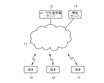
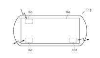
- FIG. 1 is an overall configuration diagram of a communication system according to an embodiment of the present invention. It is a figure which shows the external appearance of a user terminal. It is a figure which shows an example of a movement path
- FIG. 1 is an overall configuration diagram of a communication system according to an embodiment of the present invention.
- a user location management server 12 an information server 14, and a plurality of user terminals (information processing devices) 16 are connected to a computer communication network 10 such as the Internet.
- the user location management server 12 and the information server 14 are configured around a known server computer.
- the user terminal 16 is a portable computer game system driven by a battery.
- the user terminal 16 includes a touch screen 16a on the front surface as shown in FIG. 2, and uses the GPS (Global Positioning System).
- a communication unit 16d is incorporated.
- the user terminal 16 selectively uses the mobile phone communication unit 16c or the wireless LAN communication unit 16d according to the communication environment, and connects to the computer communication network 10 to perform data communication with the user location management server 12 and the information server 14. It can be done.
- the user terminal 16 repeatedly measures the position of its own device using satellite signals and holds the positioning results.
- the user terminal 16 also holds data indicating the execution results of the game program, and the positioning results and the game execution results data are managed according to the user operation or automatically at regular intervals.
- the user location management server 12 holds the positioning result and execution result data uploaded from a large number of user terminals 16 in this way.
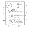
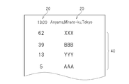
- a movement path image as shown in FIG. 3 is displayed on the touch screen 16a. Note that this moving path image has a vertically long shape, and only the display range set as a part of the touch screen 16a is displayed. And a display range can be moved when a user performs predetermined operation with respect to the touch screen 16a.
- an image showing the movement route of the user terminal 16 is displayed in the lower area of the movement route image.
- the user terminal 16 repeatedly measures its own position and holds the measured positions.
- an address character string 20 indicating a held position is displayed in the order of measurement together with the measurement time 22. That is, newer measurement results are shown above.
- the newly measured position is at least a predetermined distance (for example, 2 km) away from the latest position that is already held. Only to keep the newly measured position. Conversely, if the newly measured position is less than a predetermined distance from the latest position that is already held, the newly measured position is not held.
- the address character string 20 which shows the position which is only less than the predetermined distance is not displayed on the moving route image continuously in the vertical direction. In this way, only significant movement can be represented in the movement path image, and the movement path image can be easily understood. Moreover, useless display can be suppressed and the touch screen 16a can be used efficiently.
- a plurality of small images 24 are displayed around each measurement time 22 in the lower area of the moving route image.
- a title 26 of the game program to be noted is also displayed.
- the position that the user terminal 16 has measured and uploaded to the user position management server 12 is also measured by the user terminal 16 of another user who is a friend and uploaded to the user position management server 12. Then, a message 28 indicating that the friend was at the same position, such as “I found a footprint of friend A!”, Is displayed.
- the total number of users who have been measured by the user terminal 16 and uploaded to the user location management server 12 after the location uploaded to the user location management server 12 is displayed.
- the upper right area 32 information on other users who are friends of the user is displayed.
- FIG. 4 shows a friend image displayed on the touch screen 16a when the user taps the upper right area 32 of the movement path image of FIG.
- the avatar image 36 of each friend and the latest information 34 regarding the friend are displayed in the lower area of the friend image.
- the latest information 34 is received from, for example, the information server 14.
- the friend image is also vertically long, and only the display range set as a part thereof is displayed on the touch screen 16a. And a display range can be moved when a user performs predetermined operation with respect to the touch screen 16a.
- FIG. 5 shows a ranking image displayed on the touch screen 16a when the user taps the address character string 20 in the moving route image of FIG.
- the address character string 20 tapped by the user and the measurement time 22 of the position indicated by the address character string 20 are represented.
- the title of the game program played on the user terminal 16 that uploaded the position indicated by the address character string 20 to the user position management server 12 is displayed.
- Each title is displayed in order of the number of user terminals 16 that have played the game program of the title.
- the number of user terminals 16 on which the game program of the title is played is displayed.
- the ranking image is also vertically long, and only the display range set as a part thereof is displayed on the touch screen 16a. And a display range can be moved when a user performs predetermined operation with respect to the touch screen 16a.
- FIG. 6 shows a title displayed on the touch screen 16a when any game program title is tapped in the ranking image shown in FIG. 5 or any title 26 is tapped in the moving path image shown in FIG.
- a profile image is shown.
- the title image 42 of the game program is shown, and in the lower area, an information column 44 indicating the evaluation and play status of other users related to the game program is provided.
- the contents of the title image 42 and the information column 44 are also received from the information server 14, for example.
- the title profile image is also vertically long, and only the display range set as a part thereof is displayed on the touch screen 16a. And a display range can be moved when a user performs predetermined operation with respect to the touch screen 16a.
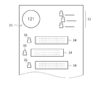
- FIG. 7 shows a radar image displayed on the touch screen 16a when the address character string 20 is tapped in the ranking image of FIG.
- An avatar image 50 representing itself is shown in the center of the radar image, and an avatar image 52 of another user whose privacy setting is “open” is shown around it.
- a small image 54 is also shown around the avatar image 50 that implies the presence of another user whose privacy setting is “private”.
- the display positions of the avatar images 50 and 52 on the touch screen 16a are determined based on the positions actually measured by the positioning unit 16b.
- the relative position of the user related to other “public” is calculated based on his / her position, and the calculated relative
- the display position of each avatar image 52 on the touch screen 16a is determined based on the target position.
- the display position of the small image 54 on the touch screen 16a is determined according to a random number.
- the user terminal 16 functionally includes a positioning unit 60, a position coordinate storage unit 62, a position coordinate transmission unit 64, an application execution unit 66, a game performance storage unit 68, another user information provision unit 70, an item.
- a communication unit 72 and an item notification unit 74 are included.
- the other user information providing unit 70 includes a movement route image generation unit 70a, a friend image generation unit 70b, a ranking image generation unit 70c, a radar image generation unit 70d, and a title profile image generation unit 70e.
- the user terminal 16 which is a computer game system.
- This program may be downloaded from another computer via the computer communication network 10, or may be stored in a computer-readable information storage medium such as a CD-ROM or DVD-ROM, and installed in the user terminal 16 therefrom.
- the user terminal 16 has a built-in or externally mounted medium reading device for reading a program from the medium.
- the positioning unit 60 is configured with the positioning unit 16b as the center.
- the positioning unit 16b is activated periodically (for example, every 30 minutes), receives satellite signals (GPS signals), and receives position coordinates (latitude and latitude). Longitude). Even when the user explicitly instructs positioning using the touch screen 16a, the positioning unit 16b may be activated to receive satellite signals and generate position coordinates therefrom.
- the positioning unit 60 may acquire the position coordinates of the user terminal 16 based on the identification information of the wireless access point that can communicate with the wireless LAN communication unit 16d and other necessary information.
- the wireless access point identification information and the position coordinates are stored in association with each other, and the positioning unit 60 transmits the identification information to the server, thereby identifying the identification information.
- Get the position coordinates associated with The positioning unit 60 transmits identification information of a plurality of wireless access points and the strength of radio waves from each wireless access point to the server, and the server weights the radio wave strength and synthesizes the position coordinates of each wireless access point.
- the position coordinates may be calculated and returned to the positioning unit 60.
- the position coordinates of the user terminal 16 may be acquired based on identification information of the mobile phone base station that can communicate with the mobile phone communication unit 16c and other necessary information.
- the wireless access point or mobile phone base station identification information and other necessary information are transmitted to the user position management server 12.
- the user position management server 12 may acquire position coordinates corresponding to the information.
- the position coordinate storage unit 62 stores a predetermined number (for example, 10) of position coordinates and the measurement date and time of the position coordinates in association with each other as shown in FIG. Each time the positioning unit 60 generates the position coordinates, the positioning unit 60 reads the position coordinates stored last in the position coordinate storage unit 62, and calculates the distance between the newly generated position coordinates and the read position coordinates. . And if it is more than predetermined distance (for example, 2 km), the newly generated position coordinate will be memorize
- predetermined distance for example, 2 km
- the oldest set of position coordinates and measurement date and time is deleted, instead The newly generated position coordinates are stored together with the measurement date and time.
- the position coordinates are not stored in the position coordinate storage unit 62 but discarded.
- the application execution unit 66 executes an application program such as a game program.
- the application program may be downloaded from another computer via the computer communication network 10 or may be stored in a computer-readable information storage medium such as a CD-ROM or DVD-ROM and installed in the user terminal 16 therefrom. .
- the game performance storage unit 68 stores the title ID, viewing level, total play time, and last play date and time of a predetermined number (for example, five) of game programs recently executed by the application execution unit 66 in association with each other. To do.
- the title ID is information for identifying individual game programs.
- the total play time is the total time that the game program has been played so far.
- the viewing level is information indicating how much the user is enthusiastic about the game, and is calculated from the total play time and the like.
- the last play date / time is the date / time (start date / time or end date / time) at which the game program was last played.
- the position coordinate transmission unit 64 includes a set of a plurality of position coordinates and measurement dates and times stored in the position coordinate storage unit 62, title IDs and viewing levels of a predetermined number of game programs stored in the game result storage unit 68,
- the set of the total play time is transmitted to the user location management server 12 using the mobile phone communication unit 16c or the wireless LAN communication unit 16d. This transmission may be performed when the user explicitly instructs transmission using the touch screen 16a. At this time, it is preferable to display a plurality of sets of position coordinates and measurement date and time stored in the position coordinate storage unit 62 on the touch screen 16 a and confirm whether or not to transmit to the user position management server 12.
- a set of position coordinates and measurement date and time that are not desired to be transmitted may be deleted so that only the remaining sets can be transmitted to the user position management server 12. Moreover, you may make a user perform the setting which omits such a confirmation. In this case, a set of a plurality of position coordinates and measurement date / time stored in the position coordinate storage unit 62 is automatically transmitted periodically (for example, once a day).
- the other user information providing unit 70, the item communication unit 72, and the item notification unit 74 will be described later.
- FIG. 12 is a functional block diagram of the user location management server 12.
- the user location management server 12 functionally includes a position coordinate receiving unit 80, a title ID storage unit 82 for each region, a user ID storage unit 84 for each region, a user information storage unit 86, a ranking generation unit 88, Each region ranking storage unit 90, a ranking distribution unit 92, a nearby user distribution unit 94, and a user information distribution unit 96 are included.
- These functions are realized by executing the program according to the embodiment of the present invention on the user location management server 12 which is a computer.
- This program may be downloaded from another computer via the computer communication network 10 or stored in a computer-readable information storage medium such as a CD-ROM or DVD-ROM and installed in the user location management server 12 therefrom. It's okay.
- the position coordinate receiving unit 80 is transmitted from the position coordinate transmitting unit 64 of the user terminal 16 and a set of a plurality of position coordinates and measurement date and time, and a predetermined number of game performance data (program title ID, viewing level and total play time) ).
- the area-by-area title ID storage unit 82 stores an area ID, a time slot, and a predetermined number (for example, 20) of game performance data in association with each other.
- the area ID is information for specifying (designating) each mesh area when the area to be managed (for example, the entire area on the earth) is divided into a large number of meshes.
- the time slot is information for specifying a time range of a predetermined time (for example, 6 hours).
- the game performance data includes a title ID, a viewing level, and a total play time. That is, the title ID storage unit 82 for each region stores a predetermined number (for example, 20) of game record data in association with the set of region IDs and time slots.
- the position coordinate receiving unit 80 When the position coordinate receiving unit 80 receives a set of a plurality of position coordinates and measurement date / time and a predetermined number of game record data from the user terminal 16, the position coordinate receiving unit 80 derives an area ID of an area including the received position coordinates. In addition, a time slot including the received measurement date and time of each position coordinate is derived. Then, the game record data received from the user terminal 16 is stored in the title ID storage unit 82 for each region in association with the derived region ID and time slot set. At this time, if a predetermined number of pieces of game record data have already been stored in the corresponding part of the title ID storage unit 82 for each area, the oldest game record data is deleted, and the game record data received this time is stored instead.
- the area-specific user ID storage unit 84 stores the user ID, the position coordinates, and the measurement date and time in association with each area ID as shown in FIG.
- the position coordinate receiving unit 80 receives a set of a plurality of position coordinates and measurement dates and times, a set of title IDs, viewing levels, and total play times of a predetermined number of game programs from the user terminal 16, each position coordinate received is included.
- the area ID of the area to be acquired is derived.
- the user ID of the user who uses the user terminal 16 the received position coordinates, and the measurement date and time are stored in association with the derived area ID. If a certain time (for example, one week) has passed since the measurement date and time, the position coordinates and the measurement date and time are deleted.
- the user information storage unit 86 stores a user ID, latest position coordinates, measurement date and time, and a predetermined number (for example, 20) of game performance data in association with each other as shown in FIG.
- the position coordinate receiving unit 80 receives a set of a plurality of position coordinates and measurement date / time and a predetermined number of game record data
- the position coordinate reception unit 80 obtains the last acquired position coordinate and its measurement date / time, and the received predetermined number of game record data.
- the user information is stored in the user information storage unit 86 in association with the user ID of the user using the user terminal 16.
- the ranking generation unit 88 generates a game title ranking for each area ID in accordance with the stored contents of the area-by-area title ID storage unit 82. For example, the number of game performance data stored in the title ID storage unit 82 for each region is tabulated for each title ID in association with a time slot included in a certain past period (such as one month) for each region ID. The top 10 are generated as rankings.
- the ranking data includes the total number of game results data (total number of players) for each title ID.
- the viewing level of the game performance data stored in the title ID storage unit 82 for each area is averaged for each title ID in association with a time slot included in a certain past period (such as one month) for each area ID,
- the top 10 average values are generated as rankings.
- This ranking data also includes the total number of game results data (total number of players) for each title ID.
- the generated ranking data is stored in the ranking storage unit 90 for each region in association with the region ID. Further, when receiving the position coordinates from the user terminal 16, the ranking distribution unit 92 derives the area ID of the area including the position coordinates and stores the area ID in the area-based ranking storage unit 90 in association with the derived area ID. The ranking is read out and returned to the user terminal 16.
- the neighboring user distribution unit 94 Upon receiving the position coordinates and the size specification of the search area from the user terminal 16, the neighboring user distribution unit 94 includes n ⁇ n (1 ⁇ 1, 3) including an area including the received position coordinates (for example, at the center position). ( ⁇ 3, 5 ⁇ 5, 7 ⁇ 7, 9 ⁇ 9,..., 25 ⁇ 25, etc.) are set as search regions.
- n is determined according to the search area size designation received from the user terminal 16.
- a set of the user ID and the position coordinates stored in the area-specific user ID storage unit 84 in association with the area ID of each area constituting the determined search area is read and returned to the user terminal 16.
- the user information distribution unit 96 When the user information distribution unit 96 receives the user ID from the user terminal 16, the user information distribution unit 96 returns the latest position coordinates, the measurement date and time, and a predetermined number of game record data stored in the user information storage unit 86 in association with the user ID. When the user terminal 16 wants to display game titles played by a specific user on the touch screen 16a, the user terminal 16 may receive the information from the user information distribution unit 96.
- the other user information providing unit 70 of the user terminal 16 includes the movement route image generation unit 70a, the friend image generation unit 70b, the ranking image generation unit 70c, the radar image generation unit 70d, and the title profile image generation unit 70e. It is out.
- the movement route image generation unit 70a generates a movement route image shown in FIG.
- the movement path image generation unit 70 a reads each position coordinate and measurement date and time stored in the position coordinate storage unit 62.
- the address character string 20 corresponding to each position coordinate is acquired.
- the address character string 20 may be stored in advance in the user terminal 16 in association with the range of position coordinates, or may be stored in the information server 14 in the same manner. In the latter case, when the position coordinates are transmitted to the information server 14, the information server 14 reads the address character string 20 associated with the range including the position coordinates and returns it to the user terminal 16.
- the address character string 20 thus acquired is included in the moving route image in the order of the measurement date and time together with the measurement time 22. That is, the measurement time 22 and the address character string 20 are arranged side by side, and the set of each measurement time 22 and the address character string 20 is arranged so that the newer the measurement date and time is on the screen.
- the movement route image generation unit 70a transmits each position coordinate stored in the position coordinate storage unit 62 to the user position management server 12 and requests a ranking.
- the ranking distribution unit 92 of the user position management server 12 derives the area ID of the area including the received position coordinates, and is stored in the per-area ranking storage unit 90 in association with the derived area ID.
- the ranking is read and returned to the user terminal 16. If the movement path image generation unit 70a has already received a ranking associated with the same area ID from the user position management server 12, the movement path image generation unit 70a compares the rankings.
- the title with the highest ranking game title and the title with the highest ranking (the total number of game performance data, the average value of viewing levels, etc.) is taken as the title of interest, and the title name is included in the travel route image ( 26). Also, if the ranking associated with the same area ID has not been received from the user location management server 12 yet, for example, if the first-ranked game title in the ranking received this time is the title of interest and the title name is included in the movement path image Good.
- the movement route image generation unit 70a transmits each position coordinate stored in the position coordinate storage unit 62 and a size designation with 1 ⁇ 1 area as a search area to the user position management server 12, Request user search.
- the nearby user distribution unit 94 of the user position management server 12 derives the area ID of the area including the received position coordinates and stores it in the area-specific user ID storage unit 84 in association with the area ID. All sets of user IDs and position coordinates are read out and returned to the user terminal 16.
- the movement path image generation unit 70a counts the number of user IDs corresponding to each position coordinate, and displays the small images 24 corresponding to the number in the vicinity of the measurement date and time related to the position coordinate. In addition, the numbers corresponding to the respective position coordinates are added and the numerical values are included in the upper left region 30.
- the user terminal 16 stores the user IDs of the user's friend of the user terminal 16, receives information associated with the user IDs from the information server 14, and includes them in the upper right region 32. Moreover, if the user ID of the friend memorize
- the friend image generation unit 70b generates a friend image shown in FIG.
- the friend image generating unit 70b reads the user ID of the friend stored in the user terminal 16, and obtains the avatar image 36 and the latest information 34 associated with the user ID from the information server 14. Receive.
- the latest information 34 includes, for example, messages input from the user terminal 16 and other computers by each user, game program execution status automatically generated by the game program executed by the user terminal 16 and other computers (game progress / play This is a message indicating the skill of the user. Then, by including them in the lower area of the friend image, the friend image is completed.
- the friend image generated in this way is displayed on the touch screen 16a.
- the ranking image generation unit 70c generates the ranking image shown in FIG.
- the ranking image generation unit 70 c transmits the position coordinates designated by the user to the user position management server 12 and receives ranking data from the ranking distribution unit 92.
- a ranking image is generated based on the ranking data received in this way.
- the generated ranking image is displayed on the touch screen 16a.
- the ranking image generation unit 70c receives ranking data relating to a plurality of position coordinates (for example, all position coordinates) stored in the position coordinate storage unit 62, and also obtains numerical values ( The total number of game results data and the average value of viewing levels may be totaled for each title, ranking may be generated based on the total value, and ranking images may be generated and displayed. By doing this, it is possible to display a comprehensive ranking at a plurality of positions visited by the user.
- Title profile image generation unit 70e generates a title profile image shown in FIG.
- the title profile image generation unit 70e transmits the title ID to the information server 14 and receives information to be described in the title image 42 and the information column 44. And a title profile image is produced
- the generated title profile image is displayed on the touch screen 16a.
- the radar image generation unit 70d generates a radar image shown in FIG.
- the radar image generation unit 70d first sets a position specified by the user out of the position coordinates stored in the position coordinate storage unit 62 and a 1 ⁇ 1 area as a search area.
- the designation is transmitted to the user location management server 12 to request a search for nearby users.
- the user ID and the position coordinate which are returned from the near user distribution part 94 of the user position management server 12 are received. If the number of received user IDs is less than 10, then the same position coordinates are transmitted to the user position management server together with the size designation with 2 ⁇ 2 areas as search areas, and the search for nearby users is performed again. Request.
- the proximity user search is repeatedly executed until the number of received user IDs and position coordinates is 10 or more, or the search area is M ⁇ M areas (M is a predetermined number).
- a radar image is generated based on the user ID and position coordinates received from the nearby user distribution unit 94.
- the user's own avatar image 50 stored in advance is read from the user terminal 16 and placed in the central portion of the touch screen 16a. Further, the difference between the position coordinates designated by the user and each position coordinate received from the neighboring user distribution unit 94 is calculated, and the display position of each avatar image 52 indicating another user is determined. That is, each avatar image 52 is displayed according to the relative position of the other user terminal 16 with respect to the user terminal 16.
- the sum of the total number of players received from the ranking distribution unit 92 when generating the movement path image (the sum of the total number of players for the entire title) is obtained, and a small image 54 corresponding to the total number is displayed in the radar image. Arrange randomly. The radar image generated in this way is also displayed on the touch screen 16a.
- the item communication unit 72 exchanges data such as items used in the game program.
- the application execution unit 66 When the application execution unit 66 generates an item when executing the game program, the title ID that is the identification information of the game program and the identification information (item ID) of the item are associated with each other and stored in the game record storage unit 68. .
- the title ID and the item ID are stored in the user position management server together with each position coordinate stored in the position coordinate storage unit 62. 12 to send.
- the user position management server 12 stores the combination of the title ID, the item ID, and the user ID in association with the area ID of the area including each position coordinate.
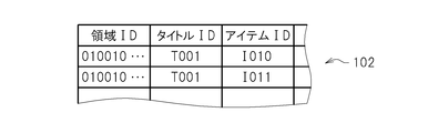
- FIG. 16 schematically shows an example of the gift data 100 stored in the user location management server 12. As described above, the upload of the item ID is completed.
- the user location management server 12 also stores treasure data 102 illustrated in FIG. 17 including an area ID, title ID, item ID, and the like in advance.
- the gift data 100 and the treasure data 102 may be associated with data indicating an expiration date, a predetermined condition (for example, usable only when being a friend), and the like.
- the item communication unit 72 also performs a process of receiving the gift data 100 and the treasure data 102 stored in the user location management server 12 at a predetermined timing.
- the position coordinates stored in the position coordinate storage unit 62 are transmitted to the user position management server 12.
- a predetermined number of area groups for example, p ⁇ p corresponding to 100 km square
- the gift data 100 and the treasure data 102 stored in association with one of the region IDs of the region group) are returned.
- the item communication unit 72 associates the received gift data 100 and treasure data 102 with the position coordinates transmitted to the user position management server 12 and the reception date and time of the gift data 100 and treasure data 102, and the game result storage unit 68.
- the item communication unit 72 associates the received gift data 100 and treasure data 102 with the position coordinates transmitted to the user position management server 12 and the reception date and time of the gift data 100 and treasure data 102, and the game result storage unit 68.
- the item communication unit 72 stores the gift data 100 and the treasure data 102 to be stored in the game record storage unit 68 when storing the gift data 100 and the treasure data 102 in the game record storage unit 68. If already stored, the data is not written to the game record storage unit 68. In the present embodiment, the item communication unit 72 is specified based on the position coordinates stored in the position coordinate storage unit 62 when the gift data 100 and the treasure data 102 are stored in the game result storage unit 68.
- An area that does not belong to a predetermined number of area groups (for example, a p ⁇ p area group corresponding to 100 km square) including an area including the position coordinates stored in the position coordinate storage unit 62 (for example, at the center position)
- the gift data 100 and the treasure data 102 stored in association with the area ID are deleted. In this way, in this embodiment, the storage capacity of the user terminal 16 can be prevented.
- data indicating the reception confirmation time of the gift data 100 and the treasure data 102 (for example, data indicating confirmation at 1 am every day) is stored in the user terminal 16 in advance. Then, at the reception confirmation time indicated by this data, the item communication unit 72 uses the position coordinates associated with the reception date and time of the previous data in the gift data 100 and the treasure data 102 stored in the position coordinate storage unit 62. Then, based on the latest position coordinates stored in the position coordinate storage unit 62, the moving distance of the user terminal 16 from the previous data reception time is calculated. Then, the item communication unit 72 determines whether or not the calculated moving distance exceeds a predetermined first reference distance (for example, 2 km).
- a predetermined first reference distance for example, 2 km
- the item communication unit 72 transmits the latest position coordinates stored in the position coordinate storage unit 62 to the user position management server 12 as described above. Then, the user position management server 12 returns the gift data 100 and the treasure data 102 stored in association with one of the area IDs of a predetermined number of area groups including the area including the received position coordinates. On the other hand, when it is determined that it does not exceed, the item communication unit 72 does not receive the gift data 100 and the treasure data 102. In this way, the item communication unit 72 determines whether or not to receive the gift data 100 and the treasure data 102 at predetermined time intervals (for example, at intervals of one day).
- the item communication unit 72 corresponds to the reception date and time of the previous data stored in the position coordinate storage unit 62 every time the latest position coordinate is stored in the position coordinate storage unit 62. Based on the position coordinates (for example, the position coordinates associated with the reception date and time closest to the reception date and time of the previous data) and the latest position coordinates stored in the position coordinate storage unit 62, the previous data is received. The moving distance of the user terminal 16 from the time is calculated. Then, the item communication unit 72 determines whether or not the calculated moving distance exceeds a predetermined second reference distance (for example, 50 km). When it is determined that the number has exceeded, the item communication unit 72 transmits the latest position coordinates stored in the position coordinate storage unit 62 to the user position management server 12 as described above.
- a predetermined second reference distance for example, 50 km
- the user position management server 12 returns the gift data 100 and the treasure data 102 stored in association with one of the area IDs of a predetermined number of area groups including the area including the received position coordinates.
- the predetermined second reference distance for example, 50 km
- the predetermined second reference distance is an area composed of a predetermined number of area groups (for example, a p ⁇ p area group corresponding to 100 km square). It is half the length of one side (for example, 100 km).
- a circular area having a radius of a predetermined second reference distance is specified by the user position management server 12 based on position coordinates transmitted from the user terminal 16 to the user position management server 12.
- a region composed of a number of region groups for example, a p ⁇ p region group corresponding to 100 km square.
- a p ⁇ p region group corresponding to 100 km square.
- a circular area having a radius of a predetermined second reference distance (for example, 50 km) may coincide with an area composed of the predetermined number of area groups.
- the item communication unit 72 receives the gift data 100 and the treasure data 102.
- a predetermined time interval for example, one day interval
- the item communication unit 72 receives the gift data 100 and the treasure data 102.
- the item notification section 74 is specified based on the position coordinates and includes an area including the position coordinates (for example, at the center position) q ⁇ It is determined whether or not gift data 100 and treasure data 102 associated with any region ID of q (here, q ⁇ p) region groups are stored in the game result storage unit 68. And when it determines with memorize
- the user terminal 16 when the user terminal 16 includes a vibrator, vibrate the vibrator; when the user terminal 16 includes a speaker, output a sound (for example, an alarm sound) from the speaker; Or the like to notify the outside that the gift data 100 and the treasure data 102 exist (notify the user). In this way, the user can know that the gift data 100 and the treasure data 102 exist.
- the gift data 100 and the treasure data 102 associated with one of the region IDs of the q ⁇ q region group including the latest position coordinates specified based on the latest position coordinates are stored in the game.
- the presence of the gift data 100 and the treasure data 102 is detected depending on whether or not it is stored in the result storage unit 68, it is detected whether the gift data 100 and the treasure data 102 near the user terminal 16 are present. Even when the user position management server 12 and the user terminal 16 cannot communicate with each other at the time of detection, this can be performed.
- the items identified by the item IDs included in the gift data 100 and the treasure data 102 stored in the game record storage unit 68 can be used in the game program executed by the application execution unit 66.
- the confirmation image 104 may be displayed on the display.
- a gift data confirmation image 104 showing the expiration date may be displayed on the display.
- the same treasure data confirmation image (Not shown) may be displayed on the display.
- the item communication unit 72 may store only data satisfying the condition in the game result storage unit 68.
- the degree of compatibility is calculated based on the user ID of the user and the user ID included in the gift data 100, and the notification by the item notification unit 74 is performed only when the degree of compatibility is a predetermined value or more.
- the item identified by the item ID included in the gift data 100 may be usable in the game program.
- the degree of compatibility is, for example, information related to a user ID that can be received from the information server 14 (for example, attributes such as gender, age group, title ID of the game owned, genre of content, etc.). It may be calculated based on. More specifically, for example, when the gender (or age group) of the user and the gender (or age group) of the user associated with the user ID included in the gift data 100 match, it is not so.
- the degree of compatibility may be set higher. For example, the compatibility degree may be set higher as the number of games owned by the user associated with the user ID included in the gift data 100 is larger.
- the item identified by the item ID included in the gift data 100 including the friend user ID is notified by the item notification unit 74, or the item identified by the item ID included in the gift data 100 However, it may be available in the game program.
- the game program identified by the title ID included in the gift data 100 is installed in the user terminal 16, notification by the item notification unit 74 is performed, or identification is performed by the item ID included in the gift data 100.
- the item to be played may be made available in the game program.
- the user terminal 16 when the game program identified by the title ID included in the treasure data 102 stored in the game result storage unit 68 is stored in the game result storage unit 68, the user terminal 16 If the game program identified by the title ID included in the treasure data 102 is installed in the user terminal 16 after the treasure data 102 is received, the treasure data is included in the game program.
- the item identified by the item ID included in 102 may be made available.
- the communication system described above it is possible to realize the existence of other users in the same living area without using short-range wireless communication. Further, the locus of the position measured by the positioning unit 16b can be easily displayed to the user without displaying a map on the touch screen 16a.
- this invention is not limited to the said embodiment, A various deformation
- the position coordinates in the area identified by each area ID are measured in the area-specific user ID storage unit 84 within a predetermined time (for example, one week) and uploaded to the user position management server 12.
- the user ID of the user is accumulated.
- the neighboring user distribution unit 94 specifies an area ID corresponding to the position coordinates and stores the area-specific user ID in association with the area ID.
- a set of user ID and position coordinates stored in the unit 84 is returned.
- the user terminal 16 generates a radar image based on this information, or displays the message 28 in the moving route image. That is, according to the above example, the user position management server 12 provides information regarding the user terminal 16 that has measured the position in the same area within a predetermined time (for example, one week).
- the nearby user distribution unit 94 returns the measurement date and time in addition to the user ID and the position coordinates stored in association with the specified area ID. That is, a set of user ID, position coordinates and measurement date / time is returned.
- the user terminal 16 reads the measurement date and time of each position coordinate from the position coordinate storage unit 62, selects a set whose difference in measurement date and time is within a predetermined time, and displays information related to the set. For example, the information (for example, the latest information 34) of the user identified by the user ID of the set is received from the information server 14 and displayed, or the avatar image 52 corresponding to the user ID of the set is displayed in the radar image.
- the message 28 may be displayed. In this way, information related to the user terminal 16 measured with a difference within a predetermined time within the same region can be displayed on the touch screen 16a. Further, the user terminal 16 calculates the difference between the measurement date and time and the difference between the position coordinates, and selects a set in which the difference between the measurement dates and times is within a predetermined time and the distance between the position coordinates is within a predetermined distance. Information regarding the set may be displayed. In this way, information related to the user terminal 16 that would have been close in time and location can be displayed on the touch screen 16a.
- the neighboring user distribution unit 94 specifies an area ID corresponding to the position coordinates, and sets the area ID to the area ID.
- a set of user IDs and position coordinates stored in the area-specific user ID storage unit 84 in association with each other is read out.
- a group in which the difference between the position coordinates transmitted from the user terminal 16 and the read position coordinates is within a predetermined distance is selected.
- the selected group is returned to the user terminal 16.
- the user terminal 16 generates a radar image based on this information, or displays a message 28 in the movement route image. In this way, only information related to the user terminal 16 measured within a predetermined distance can be displayed on the touch screen 16a.
- the user terminal 16 transmits the measurement date and time together with the position coordinates to the user position management server 12.
- the nearby user distribution unit 94 specifies a region ID corresponding to the received position coordinate, and sets a set of the user ID, the position coordinate, and the measurement date and time stored in the region-specific user ID storage unit 84 in association with the region ID. read out. Then, a group in which the difference between the measurement date and time transmitted from the user terminal 16 and the read measurement date and time is within a predetermined time is selected. Then, the selected group is returned to the user terminal 16.
- a pair in which the difference in measurement date and time is within a predetermined time and the difference in position coordinates is within a predetermined distance is selected, and the selected group is returned to the user terminal 16.
- the user terminal 16 generates a radar image based on the returned information or displays a message 28 in the travel route image. Even in this case, information related to the user terminal 16 that would be close in time and place can be displayed on the touch screen 16a.
- the user ID storage unit 84 for each area measures the position in the area identified by the area ID at the date and time in the time slot for each group of the area ID and the time slot. 16 stores the user ID, position coordinates, and measurement date and time. Then, the user terminal 16 transmits the measurement date and time together with the position coordinates to the user position management server 12.
- the nearby user distribution unit 94 specifies an area ID corresponding to the received position coordinate and specifies a time slot corresponding to the received measurement date. Then, a set of the user ID, position coordinates, and measurement date / time stored in the area-specific user ID storage unit 84 is returned in association with the specified area ID and the specified time slot. Then, the user terminal 16 generates a radar image based on these pieces of information or displays a message 28 in the travel route image. Even in this way, information related to the user terminal 16 that would be close in time and place can be displayed on the touch screen 16a.
Abstract
Description
Claims (10)
- 位置を順次測定する測位手段と、
プログラムで利用されるデータを位置に関連付けて記憶する装置から、前記測位手段により測定される位置を含む所定の第1の大きさの領域内の位置に関連付けられているデータを受信するデータ受信手段と、
前記測位手段により測定される位置を含む前記第1の大きさよりも小さな所定の第2の大きさの領域内に前記データ受信手段が受信したデータに関連付けられている位置が存在する際に、その旨を外部に通知する通知手段と、
前記データ受信手段が受信したデータを利用して前記プログラムを実行するプログラム実行手段と、
を含むことを特徴とする情報処理システム。 - 所定時間間隔で、前回のデータの受信の際に用いられた前記測位手段による測位位置と、前記測位手段による最新の測位位置と、の間の距離が所定の距離よりも離れているか否かを判定する判定手段、をさらに含み、
前記データ受信手段は、前記判定手段により前回のデータの受信の際に用いられた前記測位手段による測位位置と、前記測位手段による最新の測位位置と、の間の距離が所定の距離よりも離れていると判定された際に、前記測位手段による最新の測位位置を含む前記第1の大きさの領域内の位置に関連付けられているデータを前記装置から受信する、
ことを特徴とする請求項1に記載の情報処理システム。 - 前記データ受信手段は、前回のデータの受信の際に用いられた前記測位手段による測位位置と、前記測位手段による最新の測位位置と、の間の距離が所定の距離よりも離れたタイミングで、前記測位手段による最新の測位位置を含む前記第1の大きさの領域内の位置に関連付けられているデータを前記装置から受信する、
ことを特徴とする請求項1に記載の情報処理システム。 - 前記所定の距離を半径とする円形領域は、前記第1の大きさの領域に包含される、
ことを特徴とする請求項3に記載の情報処理システム。 - 前記データ受信手段は、
前回のデータの受信から所定時間が経過し、かつ、前回のデータの受信の際に用いられた前記測位手段による測位位置と、前記測位手段による最新の測位位置と、の間の距離が所定の第1の基準距離よりも離れている場合に、前記測位手段による最新の測位位置を含む前記第1の大きさの領域内の位置に関連付けられているデータを前記装置から受信し、
前回のデータの受信の際に用いられた前記測位手段による測位位置と、前記測位手段による最新の測位位置と、の間の距離が前記第1の基準距離よりも長い所定の第2の基準距離よりも離れた場合には、前回のデータの受信から前記所定時間が経過していなくても、前記測位手段による最新の測位位置を含む前記第1の大きさの領域内の位置に関連付けられているデータを前記装置から受信する、
ことを特徴とする請求項1に記載の情報処理システム。 - 前記所定の第2の基準距離を半径とする円形領域は、前記第1の大きさの領域に包含される、
ことを特徴とする請求項5に記載の情報処理システム。 - 前記プログラム実行手段は、前記データ受信手段によりデータが受信された後に当該データを利用するプログラムが前記情報処理システムにインストールされた場合、インストールされた当該プログラムの実行時に、前記データ受信手段により受信されたデータを利用して前記プログラムを実行する、
ことを特徴とする請求項1に記載の情報処理システム。 - 位置を順次測定する測位ステップと、
プログラムで利用されるデータを位置に関連付けて記憶する装置から、前記測位ステップで測定される位置を含む所定の第1の大きさの領域内の位置に関連付けられているデータを受信するデータ受信ステップと、
前記測位ステップで測定される位置を含む前記第1の大きさよりも小さな所定の第2の大きさの領域内に前記データ受信ステップで受信したデータに関連付けられている位置が存在する際に、その旨を外部に通知する通知ステップと、
前記データ受信ステップで受信したデータを利用して前記プログラムを実行するプログラム実行ステップと、
を含むことを特徴とする情報処理システムの制御方法。 - 位置を順次測定する測位手段、
プログラムで利用されるデータを位置に関連付けて記憶する装置から、前記測位手段により測定される位置を含む所定の第1の大きさの領域内の位置に関連付けられているデータを受信するデータ受信手段、
前記測位手段により測定される位置を含む前記第1の大きさよりも小さな所定の第2の大きさの領域内に前記データ受信手段が受信したデータに関連付けられている位置が存在する際に、その旨を外部に通知する通知手段、
前記データ受信手段が受信したデータを利用して前記プログラムを実行するプログラム実行手段、
としてコンピュータを機能させることを特徴とするプログラム。 - 位置を順次測定する測位手段、
プログラムで利用されるデータを位置に関連付けて記憶する装置から、前記測位手段により測定される位置を含む所定の第1の大きさの領域内の位置に関連付けられているデータを受信するデータ受信手段、
前記測位手段により測定される位置を含む前記第1の大きさよりも小さな所定の第2の大きさの領域内に前記データ受信手段が受信したデータに関連付けられている位置が存在する際に、その旨を外部に通知する通知手段、
前記データ受信手段が受信したデータを利用して前記プログラムを実行するプログラム実行手段、
としてコンピュータを機能させることを特徴とするプログラムを記憶したコンピュータ読み取り可能な情報記憶媒体。
Priority Applications (4)
| Application Number | Priority Date | Filing Date | Title |
|---|---|---|---|
| CN201280015455.XA CN103458980B (zh) | 2011-01-26 | 2012-01-25 | 信息处理系统、用于控制信息处理系统的方法、程序和信息存储介质 |
| EP12739341.1A EP2669809A4 (en) | 2011-01-26 | 2012-01-25 | INFORMATION PROCESSING SYSTEM, METHOD FOR CONTROLLING INFORMATION PROCESSING SYSTEM, PROGRAM, AND INFORMATION STORAGE MEDIUM |
| KR1020137022287A KR20130132587A (ko) | 2011-01-26 | 2012-01-25 | 정보 처리 시스템, 정보 처리 시스템의 제어 방법 및 정보 기억 매체 |
| US13/981,232 US9744447B2 (en) | 2011-01-26 | 2012-01-25 | Methods and apparatus for controlling an information processing system based on geographic position information |
Applications Claiming Priority (2)
| Application Number | Priority Date | Filing Date | Title |
|---|---|---|---|
| JP2011-014446 | 2011-01-26 | ||
| JP2011014446A JP6032692B2 (ja) | 2011-01-26 | 2011-01-26 | 情報処理システム、情報処理システムの制御方法、プログラム及び情報記憶媒体 |
Publications (1)
| Publication Number | Publication Date |
|---|---|
| WO2012102289A1 true WO2012102289A1 (ja) | 2012-08-02 |
Family
ID=46580854
Family Applications (1)
| Application Number | Title | Priority Date | Filing Date |
|---|---|---|---|
| PCT/JP2012/051502 WO2012102289A1 (ja) | 2011-01-26 | 2012-01-25 | 情報処理システム、情報処理システムの制御方法、プログラム及び情報記憶媒体 |
Country Status (6)
| Country | Link |
|---|---|
| US (1) | US9744447B2 (ja) |
| EP (1) | EP2669809A4 (ja) |
| JP (1) | JP6032692B2 (ja) |
| KR (1) | KR20130132587A (ja) |
| CN (1) | CN103458980B (ja) |
| WO (1) | WO2012102289A1 (ja) |
Cited By (3)
| Publication number | Priority date | Publication date | Assignee | Title |
|---|---|---|---|---|
| JP2012154818A (ja) * | 2011-01-26 | 2012-08-16 | Sony Computer Entertainment Inc | 情報処理装置、表示制御方法、プログラム及び情報記憶媒体 |
| WO2014024869A1 (ja) * | 2012-08-10 | 2014-02-13 | 株式会社ソニー・コンピュータエンタテインメント | 情報処理システム、情報処理装置、情報処理方法、プログラム及び情報記憶媒体 |
| JP2014038370A (ja) * | 2012-08-10 | 2014-02-27 | Sony Computer Entertainment Inc | 情報処理システム、情報処理方法、プログラム及び情報記憶媒体 |
Families Citing this family (5)
| Publication number | Priority date | Publication date | Assignee | Title |
|---|---|---|---|---|
| US9480926B2 (en) * | 2013-04-19 | 2016-11-01 | Gree, Inc. | Game server item notification system and method |
| EP2899999A1 (en) * | 2014-01-23 | 2015-07-29 | Rovio Entertainment Ltd | Location relevant data communication |
| US9351107B2 (en) | 2014-01-23 | 2016-05-24 | Rovio Entertainment Ltd | Location relevant data communication |
| JP6758820B2 (ja) * | 2015-11-18 | 2020-09-23 | マクセル株式会社 | 情報処理装置、及びその画像データ制御方法 |
| WO2023188104A1 (ja) * | 2022-03-30 | 2023-10-05 | 三菱電機株式会社 | 遠隔体験システム、情報処理装置、情報処理方法およびプログラム |
Citations (3)
| Publication number | Priority date | Publication date | Assignee | Title |
|---|---|---|---|---|
| JP2003090728A (ja) * | 2001-09-18 | 2003-03-28 | Denso Corp | 地図表示装置 |
| JP2003319435A (ja) * | 2002-04-18 | 2003-11-07 | Fujitsu Ltd | プッシュ配信サービス提供方法,情報提供サービスシステム,サーバシステムおよびユーザ端末 |
| JP2009129002A (ja) * | 2007-11-20 | 2009-06-11 | Sharp Corp | 情報処理装置、情報処理装置のプログラムおよび情報処理装置の情報報知方法 |
Family Cites Families (18)
| Publication number | Priority date | Publication date | Assignee | Title |
|---|---|---|---|---|
| DE60026872T2 (de) * | 1999-11-09 | 2007-03-15 | Sony Corp. | Informationsübertragungssystem und verfahren |
| US6650902B1 (en) * | 1999-11-15 | 2003-11-18 | Lucent Technologies Inc. | Method and apparatus for wireless telecommunications system that provides location-based information delivery to a wireless mobile unit |
| GB0012445D0 (en) * | 2000-05-24 | 2000-07-12 | Hewlett Packard Co | Location-based equipment control |
| JP3839680B2 (ja) * | 2001-03-29 | 2006-11-01 | 株式会社エヌ・ティ・ティ・ドコモ | 位置計測方法、移動通信端末、プログラム及び記録媒体 |
| US20040219961A1 (en) * | 2003-04-08 | 2004-11-04 | Ellenby Thomas William | Computer games having variable execution dependence with respect to spatial properties of a mobile unit. |
| US7430671B2 (en) * | 2004-03-31 | 2008-09-30 | Nortel Networks Limited | Systems and methods for preserving confidentiality of sensitive information in a point-of-care communications environment |
| JP4274925B2 (ja) * | 2003-12-17 | 2009-06-10 | 株式会社ナビタイムジャパン | 情報配信システムおよび情報配信サーバならびに携帯端末および情報配信方法 |
| EP1952578A4 (en) * | 2005-11-04 | 2012-08-29 | Wavemarket Inc D B A Location Labs | PROFILE BASED COMMUNICATION SERVICE |
| US7519470B2 (en) * | 2006-03-15 | 2009-04-14 | Microsoft Corporation | Location-based caching for mobile devices |
| US8565715B2 (en) | 2006-05-19 | 2013-10-22 | Alcatel Lucent | Mobile-initiated location measurement |
| KR101321240B1 (ko) * | 2007-01-16 | 2013-12-19 | 삼성전자주식회사 | 이동통신시스템에서 홈셀 또는 개인네트워크로 셀 선택하는 장치 및 방법 |
| US20090063624A1 (en) * | 2007-08-31 | 2009-03-05 | Sony Ericsson Mobile Communications Ab | Portable Electronic Devices and Methods for Downloading Applications or Events Based on Presence of Portable Electronic Devices Having a Common Element Being in a Defined Region at a Same Time |
| US20090140886A1 (en) * | 2007-12-03 | 2009-06-04 | International Truck Intellectual Property Company, Llc | Multiple geofence system for vehicles |
| JP2009271812A (ja) | 2008-05-09 | 2009-11-19 | Seiko Epson Corp | 測位システム |
| US20100205242A1 (en) * | 2009-02-12 | 2010-08-12 | Garmin Ltd. | Friend-finding system |
| JP5438377B2 (ja) * | 2009-05-18 | 2014-03-12 | 任天堂株式会社 | 情報処理プログラムおよび情報処理装置 |
| US8531293B2 (en) * | 2009-12-23 | 2013-09-10 | Lockheed Martin Corporation | Predictive geofence crossing |
| US8874130B2 (en) * | 2010-08-31 | 2014-10-28 | Qualcomm Incorporated | Method and apparatus for dynamic power savings based on location |
-
2011
- 2011-01-26 JP JP2011014446A patent/JP6032692B2/ja active Active
-
2012
- 2012-01-25 EP EP12739341.1A patent/EP2669809A4/en not_active Withdrawn
- 2012-01-25 US US13/981,232 patent/US9744447B2/en active Active
- 2012-01-25 KR KR1020137022287A patent/KR20130132587A/ko not_active Application Discontinuation
- 2012-01-25 WO PCT/JP2012/051502 patent/WO2012102289A1/ja active Application Filing
- 2012-01-25 CN CN201280015455.XA patent/CN103458980B/zh active Active
Patent Citations (3)
| Publication number | Priority date | Publication date | Assignee | Title |
|---|---|---|---|---|
| JP2003090728A (ja) * | 2001-09-18 | 2003-03-28 | Denso Corp | 地図表示装置 |
| JP2003319435A (ja) * | 2002-04-18 | 2003-11-07 | Fujitsu Ltd | プッシュ配信サービス提供方法,情報提供サービスシステム,サーバシステムおよびユーザ端末 |
| JP2009129002A (ja) * | 2007-11-20 | 2009-06-11 | Sharp Corp | 情報処理装置、情報処理装置のプログラムおよび情報処理装置の情報報知方法 |
Non-Patent Citations (1)
| Title |
|---|
| See also references of EP2669809A4 * |
Cited By (4)
| Publication number | Priority date | Publication date | Assignee | Title |
|---|---|---|---|---|
| JP2012154818A (ja) * | 2011-01-26 | 2012-08-16 | Sony Computer Entertainment Inc | 情報処理装置、表示制御方法、プログラム及び情報記憶媒体 |
| WO2014024869A1 (ja) * | 2012-08-10 | 2014-02-13 | 株式会社ソニー・コンピュータエンタテインメント | 情報処理システム、情報処理装置、情報処理方法、プログラム及び情報記憶媒体 |
| JP2014038370A (ja) * | 2012-08-10 | 2014-02-27 | Sony Computer Entertainment Inc | 情報処理システム、情報処理方法、プログラム及び情報記憶媒体 |
| US10031866B2 (en) | 2012-08-10 | 2018-07-24 | Sony Interactive Entertainment Inc. | Information processing system, information processing device, information processing method, program and information storage medium for setting download permissions or settings |
Also Published As
| Publication number | Publication date |
|---|---|
| EP2669809A4 (en) | 2016-12-21 |
| JP6032692B2 (ja) | 2016-11-30 |
| CN103458980A (zh) | 2013-12-18 |
| JP2012152395A (ja) | 2012-08-16 |
| US20130303187A1 (en) | 2013-11-14 |
| KR20130132587A (ko) | 2013-12-04 |
| US9744447B2 (en) | 2017-08-29 |
| EP2669809A1 (en) | 2013-12-04 |
| CN103458980B (zh) | 2015-12-09 |
Similar Documents
| Publication | Publication Date | Title |
|---|---|---|
| JP6032692B2 (ja) | 情報処理システム、情報処理システムの制御方法、プログラム及び情報記憶媒体 | |
| JP5747094B2 (ja) | 情報処理システム、情報処理端末、情報処理方法、プログラム及び情報記憶媒体 | |
| WO2012002426A1 (ja) | 情報処理装置、表示制御方法、プログラム及び情報記憶媒体 | |
| WO2012002425A1 (ja) | 通信システム、通信方法、プログラム及び情報記憶媒体 | |
| JP5296819B2 (ja) | 通信システム、通信方法、プログラム及び情報記憶媒体 | |
| JP5475698B2 (ja) | 情報処理装置、表示制御方法、プログラム及び情報記憶媒体 | |
| JP5436467B2 (ja) | 情報処理装置、表示制御方法、プログラム及び情報記憶媒体 | |
| JP6113134B2 (ja) | 情報処理装置、通信方法、プログラム及び情報記憶媒体 | |
| US10031866B2 (en) | Information processing system, information processing device, information processing method, program and information storage medium for setting download permissions or settings | |
| JP5997540B2 (ja) | 情報処理システム、情報処理方法、プログラム及び情報記憶媒体 | |
| JP5661862B2 (ja) | 通信端末、通信端末の制御方法、プログラム及び情報記憶媒体 | |
| JP5845155B2 (ja) | 情報処理システム、情報処理装置、情報処理方法、プログラム及び情報記憶媒体 | |
| JP6022491B2 (ja) | 情報処理装置、表示制御方法、プログラム及び情報記憶媒体 |
Legal Events
| Date | Code | Title | Description |
|---|---|---|---|
| 121 | Ep: the epo has been informed by wipo that ep was designated in this application |
Ref document number: 12739341 Country of ref document: EP Kind code of ref document: A1 |
|
| WWE | Wipo information: entry into national phase |
Ref document number: 13981232 Country of ref document: US |
|
| NENP | Non-entry into the national phase |
Ref country code: DE |
|
| WWE | Wipo information: entry into national phase |
Ref document number: 2012739341 Country of ref document: EP |
|
| ENP | Entry into the national phase |
Ref document number: 20137022287 Country of ref document: KR Kind code of ref document: A |