US5259763A - Method of using active learning maps - Google Patents
Method of using active learning maps Download PDFInfo
- Publication number
- US5259763A US5259763A US07/723,180 US72318091A US5259763A US 5259763 A US5259763 A US 5259763A US 72318091 A US72318091 A US 72318091A US 5259763 A US5259763 A US 5259763A
- Authority
- US
- United States
- Prior art keywords
- map
- students
- tabs
- tab
- states
- Prior art date
- Legal status (The legal status is an assumption and is not a legal conclusion. Google has not performed a legal analysis and makes no representation as to the accuracy of the status listed.)
- Expired - Fee Related
Links
- 238000000034 method Methods 0.000 title claims description 12
- 239000000463 material Substances 0.000 claims abstract description 37
- 230000008569 process Effects 0.000 claims description 6
- 239000002861 polymer material Substances 0.000 claims 1
- 238000012216 screening Methods 0.000 claims 1
- 230000000694 effects Effects 0.000 abstract description 15
- XLYOFNOQVPJJNP-UHFFFAOYSA-N water Substances O XLYOFNOQVPJJNP-UHFFFAOYSA-N 0.000 abstract description 5
- 238000012552 review Methods 0.000 description 8
- 238000011161 development Methods 0.000 description 7
- 230000018109 developmental process Effects 0.000 description 7
- 238000013459 approach Methods 0.000 description 4
- 239000003086 colorant Substances 0.000 description 3
- 241000196324 Embryophyta Species 0.000 description 2
- 241001465754 Metazoa Species 0.000 description 2
- 239000000853 adhesive Substances 0.000 description 2
- 230000001070 adhesive effect Effects 0.000 description 2
- 230000008901 benefit Effects 0.000 description 2
- 230000008859 change Effects 0.000 description 2
- 239000004744 fabric Substances 0.000 description 2
- 239000003550 marker Substances 0.000 description 2
- 230000005012 migration Effects 0.000 description 2
- 238000013508 migration Methods 0.000 description 2
- BASFCYQUMIYNBI-UHFFFAOYSA-N platinum Chemical compound [Pt] BASFCYQUMIYNBI-UHFFFAOYSA-N 0.000 description 2
- 241000879217 Apocynum androsaemifolium Species 0.000 description 1
- 241000612703 Augusta Species 0.000 description 1
- 241000972773 Aulopiformes Species 0.000 description 1
- 235000007279 Lewisia rediviva Nutrition 0.000 description 1
- 241000233805 Phoenix Species 0.000 description 1
- 239000004698 Polyethylene Substances 0.000 description 1
- 241000270295 Serpentes Species 0.000 description 1
- 238000003916 acid precipitation Methods 0.000 description 1
- 235000021152 breakfast Nutrition 0.000 description 1
- 230000007123 defense Effects 0.000 description 1
- 239000003814 drug Substances 0.000 description 1
- 229940079593 drug Drugs 0.000 description 1
- 230000007613 environmental effect Effects 0.000 description 1
- 239000000835 fiber Substances 0.000 description 1
- 235000013305 food Nutrition 0.000 description 1
- 239000002803 fossil fuel Substances 0.000 description 1
- 238000009432 framing Methods 0.000 description 1
- 229910052500 inorganic mineral Inorganic materials 0.000 description 1
- 238000002372 labelling Methods 0.000 description 1
- 238000004519 manufacturing process Methods 0.000 description 1
- 235000012054 meals Nutrition 0.000 description 1
- 239000011707 mineral Substances 0.000 description 1
- 238000012986 modification Methods 0.000 description 1
- 230000004048 modification Effects 0.000 description 1
- 239000003305 oil spill Substances 0.000 description 1
- 229910052697 platinum Inorganic materials 0.000 description 1
- -1 polyethylene Polymers 0.000 description 1
- 229920000573 polyethylene Polymers 0.000 description 1
- 239000011435 rock Substances 0.000 description 1
- 235000019515 salmon Nutrition 0.000 description 1
- 239000004753 textile Substances 0.000 description 1
- 230000032258 transport Effects 0.000 description 1
- 125000000391 vinyl group Chemical group [H]C([*])=C([H])[H] 0.000 description 1
- 229920002554 vinyl polymer Polymers 0.000 description 1
- 230000003442 weekly effect Effects 0.000 description 1
Images

Classifications
-
- G—PHYSICS
- G09—EDUCATION; CRYPTOGRAPHY; DISPLAY; ADVERTISING; SEALS
- G09B—EDUCATIONAL OR DEMONSTRATION APPLIANCES; APPLIANCES FOR TEACHING, OR COMMUNICATING WITH, THE BLIND, DEAF OR MUTE; MODELS; PLANETARIA; GLOBES; MAPS; DIAGRAMS
- G09B29/00—Maps; Plans; Charts; Diagrams, e.g. route diagram
- G09B29/10—Map spot or coordinate position indicators; Map reading aids
-
- G—PHYSICS
- G09—EDUCATION; CRYPTOGRAPHY; DISPLAY; ADVERTISING; SEALS
- G09B—EDUCATIONAL OR DEMONSTRATION APPLIANCES; APPLIANCES FOR TEACHING, OR COMMUNICATING WITH, THE BLIND, DEAF OR MUTE; MODELS; PLANETARIA; GLOBES; MAPS; DIAGRAMS
- G09B1/00—Manually or mechanically operated educational appliances using elements forming, or bearing, symbols, signs, pictures, or the like which are arranged or adapted to be arranged in one or more particular ways
- G09B1/02—Manually or mechanically operated educational appliances using elements forming, or bearing, symbols, signs, pictures, or the like which are arranged or adapted to be arranged in one or more particular ways and having a support carrying or adapted to carry the elements
- G09B1/04—Manually or mechanically operated educational appliances using elements forming, or bearing, symbols, signs, pictures, or the like which are arranged or adapted to be arranged in one or more particular ways and having a support carrying or adapted to carry the elements the elements each bearing a single symbol or a single combination of symbols
- G09B1/06—Manually or mechanically operated educational appliances using elements forming, or bearing, symbols, signs, pictures, or the like which are arranged or adapted to be arranged in one or more particular ways and having a support carrying or adapted to carry the elements the elements each bearing a single symbol or a single combination of symbols and being attachable to, or mounted on, the support
-
- G—PHYSICS
- G09—EDUCATION; CRYPTOGRAPHY; DISPLAY; ADVERTISING; SEALS
- G09B—EDUCATIONAL OR DEMONSTRATION APPLIANCES; APPLIANCES FOR TEACHING, OR COMMUNICATING WITH, THE BLIND, DEAF OR MUTE; MODELS; PLANETARIA; GLOBES; MAPS; DIAGRAMS
- G09B19/00—Teaching not covered by other main groups of this subclass
- G09B19/0061—Geography
-
- G—PHYSICS
- G09—EDUCATION; CRYPTOGRAPHY; DISPLAY; ADVERTISING; SEALS
- G09B—EDUCATIONAL OR DEMONSTRATION APPLIANCES; APPLIANCES FOR TEACHING, OR COMMUNICATING WITH, THE BLIND, DEAF OR MUTE; MODELS; PLANETARIA; GLOBES; MAPS; DIAGRAMS
- G09B29/00—Maps; Plans; Charts; Diagrams, e.g. route diagram
- G09B29/003—Maps
- G09B29/004—Map manufacture or repair; Tear or ink or water resistant maps; Long-life maps
Definitions
- the present invention pertains to an educational teaching map, and more particularly, pertains to an educational teaching map of loop material with location tabs of hook material.
- Prior art maps have utilized tabs or labels attached with adhesive. This has not provided an easy “see and remember” or “do and understand” approach, but more a “hear and forgot” approach.
- students use prior art markers to label the map. The marker approach proved to be messy and continual wiping of the surface eventually left the map smeared or scratched.
- Other prior art maps require pins to attach information. This leaves holes in the map and tabs.
- Prelabeled maps are generally congested so that it is difficult for students to sort out all the information or to see the development of an event over time.
- Civil War maps show the entire war.
- the map of the present invention allows the student t place tabs representing various developments prior to the outbreak and during the war by year. Thus, the students can see an event develop over time.
- Maps currently on the market deal with specific subjects (political maps, relief maps, population maps, historical maps, etc.).
- the present invention map has the advantage of being useable in a variety of disciplines (science, social studies, home economics, agriculture, English, etc.).
- Each discipline can use the base map by simply purchasing the tab packet that applies to their classroom.
- the library could purchase the base map so that teachers could check it out on the days it would be used in the classroom.
- the present invention map also involves the student in active participation in the lesson. The student does not just look at a map in the text or on the wall, but is involved in the topic development on the map.
- the present invention overcomes the disadvantages of the prior art by providing hook and loop hooked material tabs to engage a loop material for a specific subject.
- the general purpose of the present invention is to provide a looped learning map with hooked material tabs which affix to the learning map on various subjects, such as science, social studies, home economics, agriculture, English, etc.
- a hook and loop teaching map with color coded hooked tabs which affixes to silk screened loop material for various subjects.
- One significant aspect and feature of the present invention is the students' active involvement in the subject or topic development of the map in a "see and remember” or “do and understand” scheme.
- hooked color coded tabs can be placed and removed repeatedly on the looped material without the mess commonly associated with chalk/marker labeling techniques, or the holes associated with tabs placed on the map with pins.
- Another significant aspect and feature of the present invention is color coded tabs to help students identify specific educational features.
- a further significant aspect and feature of the present invention is starting with blank silk screened subject matter material and placing the tabs onto the material which assists the student develop an educational concept.
- the material allows the user to change the topic by using a variety of tab packages.
- the material is not only able to show a multitude of topics, but can also be used by a variety of disciplines.
- the material is not limited to activities suggested by the manufacturer, but by the user's imagination since the user can easily make tabs to meet the specific needs.
- One object of the present invention is to provide a blank hook and loop teaching loop material with hooked material tabs which assists students see the development of a particular concept.
- Another object of the present invention is to provide color coded tabs to help students identify specific features
- a further object of the present invention is to provide a variety of tab packages on a multitude of topics for a variety of disciplines.
- Yet another object of the present invention is that the user can easily make tabs to meet the specific need of a particular discipline.
- Additional objects of the present invention include that the material upon which the map is printed is different from the maps currently on the market.
- the present invention allows the student to place tabs representing various developments prior to the outbreak and during the war by year. Thus, the students can see an event develop over time.
- the tab approach allows the user to change the instant map to whatever subject he or she wishes to deal with at that particular time.
- FIG. 1 illustrates a plan view of a blank United States map silk screened onto loop material
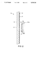
- FIG. 2 illustrates a sectional side view of the United States map with hooked educational tabs affixed thereto;
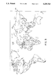
- FIG. 3 illustrates a blank World map
- FIG. 1 illustrates a plan view of a blank United States map 10 with educational material silk screened 12 onto a loop material 14, which is on a rubberized backing 16.
- the silk screen process can include a multitude of color runs, such as black and two different blues.
- the fabric color such as platinum, is used for the land colors.
- the fabric is then secured to a rigid or flexible backing 18 of a suitable material.
- the edges 20, 22, 24, and 26 can be bordered with framing material 28.
- the map size is 72 ⁇ 39 inches by way of example and for purposes of illustration only.
- Tabs 30a-30n, as illustrated in FIG. 2 are made of a rigid material, such as polyethylene, and can be color coded to denote a specific feature (state, country, ocean, mountain, etc.).
- Hooks 32 on material 34 attaches to the backside of the tabs 30a-30n through adhesive 36 which allows the user to latch the tabs 30a-30n to the loop material of the map.
- the silk screened subject matter of the map 10 or the informational material of the tabs 30a-30n can be changed, thereby changing the educational process.
- Suitable hook and loop materials can include VELCRO or SCOTHMATE.
- the tabs can be of a rigid, non-rigid, flexible vinyl.
- FIG. 2 illustrates a sectional side view of the silk screened looped United States map 10 with hooked material tabs 30a-30n affixed thereto. All other numerals correspond to those elements previously described.
- the map 10 includes a rigid backing 18, a backing material 16, loop material 14, and silk screened information 12.
- FIG. 3 illustrates a blank World 50 silk screened onto loop material.
- the hook and loop teaching instruction material allows the student to become involved in the learning process through active participation in the lesson.
- the maps are essentially large blank maps which show the outlines of states/countries, and various major water bodies, rivers and cities. More detail may be added by the user as so desired
- the size allows the map to be used for large group, as well as small group and individual activities. Suggested teaching activities and map keys are included with each map. Each user can adapt the map to his or her particular style of teaching.
- the map can be used in other disciplines besides social studies.
- English teachers may have students use the map to locate the setting of a story or place pictures of regional authors.
- Home Economics teachers can use the map to show regional foods and the location of the natural fibers for textile production.
- Science teachers can have students locate various mineral deposit and fossil fuels (for example, energy producing states).
- the aquifers and biomes can also be placed on the map.
- Agricultural teachers may use the map to identify leading states producing a particular agricultural product.
- the teacher can have a student place the name tags of his/her home state on the map. Now placing the moveable compass on that state, the teacher can ask what sate, country, or body of water is north, east, south and west of the student's home state. Individual students may volunteer to place the correct tabs on the map. When the teacher feels that the students know their map directions, this exercise may be repeated without the compass.
- the moveable compass may be used by a student to challenge another student to name what is north, east, south and west of the state upon which the student has placed the compass. Again, as students become more familiar with map directions, this exercise may be repeated without the compass.
- Students may be asked to place the state name tags on states in which they have lived, visited or have relatives living. Name tags of other states which the students can identify may also be placed on the map. This provides an opportunity for the teacher to determine which states cannot be identified and which students may need help.
- Students may be asked to clip a news article with a dateline or that mentions a city/state in the article. Place the headline and first paragraph on poster board and attaching a piece of hook and loop, allows the students to create their own weekly current event map.
- the map may be used to help students learn lines of longitude and latitude. After giving the location in degrees, the teacher may ask the student to place the correct state or city tab at the location. If students do not know the states or cities, then the teacher may place the tabs on the map before the exercise and have the students remove the correct tab when given its approximate location by degrees.
- the teacher can have the class determine how many time zones the U.S. has by providing certain information. Each time zone is 15 degrees. Using the lines of longitude and the lines of latitude for the beginning of the first time zone, the students can determine how many time zones are found in the U.S. Once the correct answer is determined, the students can determine which states are in which time zone. Allowance must be made for various state adjustments and the fact that lines of longitude on flat maps are somewhat distorted.
- the teacher may place a clock on the map and challenge a student to come forward to select the clock which shows the correct time for a state/city in another time zone. This exercise helps the student review the states/cities and to apply his/her knowledge of time zones.
- the mobility of a society can be shown by having each student list their birth place, as well as their parents and grandparents Then using the letters S, P, and GP, write the number of students, parents and grandparents (S11-2, P-3) born in a particular state on a poster board tab. Next have the students place the tab on the correct state Using a different colored tab for each group would help the students determine the degree of mobility, if any, that has occurred in the lives of their families and classmates, families. If the class is small enough, each student may make personal tabs. First select three colors which all students will use. Once the students have determine which color represents students, parents and grandparents, have them write their names on the student color, their name and a P on the parent tabs, and their name and GP on the grandparent tab. Each student can place his/her tabs correctly on the map.
- Tabs can be made showing each team's logo. Students can learn the location of many major cities by placing the logo next to the city in which the team plays (not all professional sports cities are on the map). Again, have students determine as to why teams are located where they are. Showing the location of teams by decades (40s, 50s, 60s, 70s, and 80s) also may help students to see population movement to the south and west. Moving the teams to where they are playing during the week or on the weekend would help reenforce the location of various major cities.
- Students can determine the major economic activity of various areas of the U.S. by placing symbols on the map to show the major economic activities found within a particular state. The teacher can ask the students what role geography plays in these leading activities.
- Interdependence of the states can be shown by having students cut the brand name and the name of the company and its location from products found in their homes. For example, the teacher may select a meal to see what the students ate for breakfast, lunch or dinner. The information may be glued to a small poster board tab and placed on the map where the company is located. This activity could be ongoing as students try to find a product from each state.
- the students can identify the land areas of the various territories which were added to the original thirteen states to create the present day shape of the U.S.
- symbols can be created to represent the method of acquiring the land.
- a picture of the president in office may also be added to the map.
- the map can be used to analyze presidential elections. Using different colors for Republicans and Democrats, have the students place Rs and Ds on the states, as well as the state's electoral vote. This allows the student to see any regional trends that have occurred in the election.
- the makeup of a state's delegation to Congress by party affiliation, as well as the party of its governor may be placed on the map to determine if there is a difference in a state's national and state voting pattern. If such a difference appears, students can be asked to give some reasons for the difference.
- Students may be asked to clip current news articles that identify social/economic, environmental, or other major social problems facing the nation (examples, acid rain, illegal immigration, oil spill pollution, drug trafficking, homelessness, etc.). By placing the headline and first paragraph in the state/region, the student can see which state/region is most directly affected by the problem.
- Review numbers can be used to give a quiz of 15 items. Simply by placing the numbers on the map, the teacher can have the students name the state, city, etc. which would match the number's location. Review numbers can be used to help the students learn to spell. Using the first letter of state names, the teacher may place the numbers so that number one is the first letter of the word, number two is the second, etc. Once students have learned other features of the map such as rivers, cities, and mountains, the first letter of each of these can also be used. Students are thus reviewing locations and learning to spell various words.
Landscapes
- Engineering & Computer Science (AREA)
- Physics & Mathematics (AREA)
- Theoretical Computer Science (AREA)
- Business, Economics & Management (AREA)
- Educational Administration (AREA)
- Educational Technology (AREA)
- General Physics & Mathematics (AREA)
- Mathematical Physics (AREA)
- Entrepreneurship & Innovation (AREA)
- Management, Administration, Business Operations System, And Electronic Commerce (AREA)
Abstract
Silk screened United States, world, regional or individual continent, country and state maps on a looped backed material, which illustrate the outline of the states, countries, as well as the location of pertinent rivers, water bodies and major cities/capitals. The locations are not labeled on the map, but instead, location names are provided on a small tab. At least one small square of hook material attaches to the backside of the tab, and can be correctly placed on the map at predetermined points and easily removed from the map for further usage. The hooks on the tab engage into the loops of the map. Other activities can be utilized, such as numbers, spellings, or other educational activities with hooked tabs engaging onto the loop material.
Description
This application is a continuation of U.S. Ser. No. 07/520,081, filed on May 7, 1990, now abandoned, entitled "Method and Apparatus to Increase Geographic Awareness Through the Use of Active Learning Maps", which is a continuation of U.S. Ser. No. 07/350,233, filed on May 11, 1989, now abandoned, entitled "Method and Apparatus to Increase Geographic Awareness Through the Use of Active Learning Maps", both to the same assignee as this patent application.
1. Field of the Invention
The present invention pertains to an educational teaching map, and more particularly, pertains to an educational teaching map of loop material with location tabs of hook material.
2. Description of the Prior Art
Prior art maps have utilized tabs or labels attached with adhesive. This has not provided an easy "see and remember" or "do and understand" approach, but more a "hear and forgot" approach. In other prior art methods, students use prior art markers to label the map. The marker approach proved to be messy and continual wiping of the surface eventually left the map smeared or scratched. Other prior art maps require pins to attach information. This leaves holes in the map and tabs.
Prelabeled maps are generally congested so that it is difficult for students to sort out all the information or to see the development of an event over time. For example, Civil War maps show the entire war. The map of the present invention allows the student t place tabs representing various developments prior to the outbreak and during the war by year. Thus, the students can see an event develop over time.
Maps currently on the market deal with specific subjects (political maps, relief maps, population maps, historical maps, etc.). Thus, the present invention map has the advantage of being useable in a variety of disciplines (science, social studies, home economics, agriculture, English, etc.). Each discipline can use the base map by simply purchasing the tab packet that applies to their classroom. For those classrooms where a map is not used daily, the library could purchase the base map so that teachers could check it out on the days it would be used in the classroom. The present invention map also involves the student in active participation in the lesson. The student does not just look at a map in the text or on the wall, but is involved in the topic development on the map.
The present invention overcomes the disadvantages of the prior art by providing hook and loop hooked material tabs to engage a loop material for a specific subject.
The general purpose of the present invention is to provide a looped learning map with hooked material tabs which affix to the learning map on various subjects, such as science, social studies, home economics, agriculture, English, etc.
According to one embodiment of the present invention, there is provided a hook and loop teaching map with color coded hooked tabs which affixes to silk screened loop material for various subjects.
One significant aspect and feature of the present invention is the students' active involvement in the subject or topic development of the map in a "see and remember" or "do and understand" scheme.
Another significant aspect and feature of the present invention is that hooked color coded tabs can be placed and removed repeatedly on the looped material without the mess commonly associated with chalk/marker labeling techniques, or the holes associated with tabs placed on the map with pins.
Another significant aspect and feature of the present invention is color coded tabs to help students identify specific educational features.
A further significant aspect and feature of the present invention is starting with blank silk screened subject matter material and placing the tabs onto the material which assists the student develop an educational concept.
Another significant aspect and feature of the present invention s that the material allows the user to change the topic by using a variety of tab packages. Thus, the material is not only able to show a multitude of topics, but can also be used by a variety of disciplines.
Yet a further significant aspect and feature of the present invention is that the material is not limited to activities suggested by the manufacturer, but by the user's imagination since the user can easily make tabs to meet the specific needs.
Having thus described the embodiments of the present invention, it is the principal object hereof to provide a hook and loop teaching loop material with hooked instructional tabs.
One object of the present invention is to provide a blank hook and loop teaching loop material with hooked material tabs which assists students see the development of a particular concept.
Another object of the present invention is to provide color coded tabs to help students identify specific features
A further object of the present invention is to provide a variety of tab packages on a multitude of topics for a variety of disciplines.
Yet another object of the present invention is that the user can easily make tabs to meet the specific need of a particular discipline.
Additional objects of the present invention include that the material upon which the map is printed is different from the maps currently on the market. The present invention allows the student to place tabs representing various developments prior to the outbreak and during the war by year. Thus, the students can see an event develop over time. The tab approach allows the user to change the instant map to whatever subject he or she wishes to deal with at that particular time.
Other objects of the present invention and many of the attendant advantages of the present invention will be readily appreciated as the same becomes better understood by reference to the following detailed description when considered in connection with the accompanying drawings, in which like reference numerals designate like parts throughout the figures thereof and wherein:
FIG. 1 illustrates a plan view of a blank United States map silk screened onto loop material;
FIG. 2 illustrates a sectional side view of the United States map with hooked educational tabs affixed thereto; and,
FIG. 3 illustrates a blank World map.
FIG. 1 illustrates a plan view of a blank United States map 10 with educational material silk screened 12 onto a loop material 14, which is on a rubberized backing 16. The silk screen process can include a multitude of color runs, such as black and two different blues. The fabric color, such as platinum, is used for the land colors. The fabric is then secured to a rigid or flexible backing 18 of a suitable material. The edges 20, 22, 24, and 26 can be bordered with framing material 28. The map size is 72×39 inches by way of example and for purposes of illustration only. Tabs 30a-30n, as illustrated in FIG. 2, are made of a rigid material, such as polyethylene, and can be color coded to denote a specific feature (state, country, ocean, mountain, etc.). Hooks 32 on material 34 attaches to the backside of the tabs 30a-30n through adhesive 36 which allows the user to latch the tabs 30a-30n to the loop material of the map. The silk screened subject matter of the map 10 or the informational material of the tabs 30a-30n can be changed, thereby changing the educational process. Suitable hook and loop materials can include VELCRO or SCOTHMATE. The tabs can be of a rigid, non-rigid, flexible vinyl.
FIG. 2 illustrates a sectional side view of the silk screened looped United States map 10 with hooked material tabs 30a-30n affixed thereto. All other numerals correspond to those elements previously described. The map 10 includes a rigid backing 18, a backing material 16, loop material 14, and silk screened information 12.
FIG. 3 illustrates a blank World 50 silk screened onto loop material.
The hook and loop teaching instruction material allows the student to become involved in the learning process through active participation in the lesson. The maps, by way of example and for purposes of illustration, are essentially large blank maps which show the outlines of states/countries, and various major water bodies, rivers and cities. More detail may be added by the user as so desired The size allows the map to be used for large group, as well as small group and individual activities. Suggested teaching activities and map keys are included with each map. Each user can adapt the map to his or her particular style of teaching.
The map can be used in other disciplines besides social studies. English teachers may have students use the map to locate the setting of a story or place pictures of regional authors. Home Economics teachers can use the map to show regional foods and the location of the natural fibers for textile production. Science teachers can have students locate various mineral deposit and fossil fuels (for example, energy producing states). The aquifers and biomes can also be placed on the map. Agricultural teachers may use the map to identify leading states producing a particular agricultural product.
The following tables, by way of example and for purposes of illustration only, are for purposes of illustrating the principals of one embodiment of teaching applications.
              TABLE 1
______________________________________
           Mexico
           Canada
           Atlantic Ocean
           Pacific Ocean
           Rocky Mts.
______________________________________
              TABLE 2
______________________________________
          Gulf of Mexico
          Atlantic Coastal Plain
          Gulf Coast Plains
          Great Plains
          Central Plains
          Appalachian Mts.
______________________________________
              TABLE 3
______________________________________
          Piedmont Plateau
          Ozark Plateau
          Edwards Plateau
          Cumberland Plateau
          Colorado Plateau
          Columbia Plateau
______________________________________
              TABLE 4
______________________________________
Sierra Nevada Mts.
Cascade Mountains
               Delaware    Pennsylvania
New Jersey     Georgia     Connecticut
Massachusetts  Maryland    South Carolina
New Hampshire  Virginia    New York
North Carolina Rhode Island
                           Vermont
Kentucky       Tennessee   Ohio
Louisiana      Indiana     Mississippi
Illinois       Alabama     Maine
Missouri       Arkansas    Michigan
Florida        Texas       Iowa
Wisconsin      California  Minnesota
Oregon         Kansas      West Virginia
Nevada         Nebraska    Colorado
North Dakota   South Dakota
                           Montana
Washington     Idaho       Wyoming
Utah           Oklahoma    New Mexico
Arizona        Alaska      Hawaii
______________________________________
              TABLE 5
______________________________________
New York   Las Vegas   Helena     Los Angeles
Olympia    Philadelphia
                       San Diego  Boise
Pittsburgh San Francisco
                       Cheyenne   Baltimore
Portland   Salt Lake City
                       Miami      Seattle
Oklahoma City
           Tampa Bay   Dover      Santa Fe
Jacksonville
           Harrisburg  Phoenix    Birmingham
Trenton    Janeau      Memphis    Atlanta
Honolulu   Louisville  Hartford   Cincinnati
Boston     Cleveland   Annapolis  Detroit
Columbia   Chicago     Concord    Milwaukee
Richmond   Minneapolis Albany     St. Louis
Raleigh    Kansas City Houston    Providence
New Orleans
           Montpelier  Frankfort  San Antonio
Nashville  Dallas      Columbus   Ft. Worth
Baton Rouge
           Indianapolis
                       Jackson
______________________________________
              TABLE 6
______________________________________
Great Salt Lake
             Ohio River     Springfield
Lake Superior
             Cumberland River
                            Montgomery
Lake Michigan
             Tennessee River
                            Augusta
Lake Huron   Alabama River  Jefferson City
Lake Erie    James River    Little Rock
Lake Ontario Hudson River   Lansing
Sacramento River
             Yukon River    Tallahassee
Columbia River              Austin
Snake River                 Des Moines
Colorado River
             Mojave Desert  Madison
Missouri River
             Great Basin    Sacramento
Platte River Painted Desert St. Paul
Yellowstone River
             Sonoran Desert Salem
Arkansas River
             Great Salt Lake
                            Topeka
             Desert
Rio Grande River
             Sevier Desert  Charleston
Red River    Amargosa Desert
                            Carson City
Des Moines River            Lincoln
Mississippi River           Denver
Illinois River
             Coast Range    Bismarck
Wabash River                Pierre
______________________________________
              TABLE 7
______________________________________
          Great Smoky Mts.
          Blue Ridge Mts.
          Allegheny Mts.
          Cumberland Mts.
          Adirondack Mts.
          Green Mts.
          White Mts.
          Catskill Mts.
          Teton Mts.
          Bitterroot Mts.
          San Juan Mts.
          Sangre de Cristo Mts.
          Clearwater Mts.
          Salmon River Mts.
______________________________________
              TABLE 8
______________________________________
1          2      3           4     5
6          7      8           9    10
11         12     13          14   15
______________________________________
TABLE 9 ______________________________________ 1. States 2. Capitals/Major Cities 3. Rivers/Water Bodies 4. Mountains/Plains/Plateaus/Deserts/Hills 5. Review Numbers 6. Geographic Regions of the United States 7. Leading Economic Activities of the Region 8.Geographic Landmarks 9.Historical Landmarks 10. Points of Interest 11. Biomes - Plant/Animal Life 12. Settling the U.S. a. Native Americans b. Europeans - Exploration and Settlement c. Roads and Trails West d. Movement West - Pre-Civil War e. Movement West - Post Civil War f. Immigration - Old/New/Present 13. Wars a. French and Indian b. Revolutionary c. 1812 d. Civil War e. Indian 14. Regional Authors/Major Works 15. Resources of theUnited States 16. Folklore of the United States 17.Time Zones 18. Professional Teams (City Locations) 19. Elections a. President/residences at election b. Electoral vote c. Congressional d. State Offices 20. Trip Game 21. State Birds/Flowers ______________________________________
TABLE 10 ______________________________________ 1. Continents/Islands/Peninsulas/Isthmus 2. Rivers/Water Bodies/Straits 3. Mounts/Deserts 4. Review Numbers 6. World Biomes - Plant/Animal Life 7. Age of Discovery 8. World Resources/Major Producing Countries 9. Our Cultural Heritage -World Literature 10. World Migration - Early Man 11.Ocean Currents 12. Countries 13.Defense Alliances 14. Economic Alliances 15.Time Zones 16. Ancient Civilizations 17.World Explorers 18. Economic Interdependence 19. World War I and II ______________________________________
By way of example and for purposes of illustration only, using the moveable compass, place the compass on the map so that north on the compass is pointing the same direction as the direction arrow on the map is pointing. Students can now see according to the compass, that the right side of the map is east, the bottom is south and the left side is west.
The teacher can have a student place the name tags of his/her home state on the map. Now placing the moveable compass on that state, the teacher can ask what sate, country, or body of water is north, east, south and west of the student's home state. Individual students may volunteer to place the correct tabs on the map. When the teacher feels that the students know their map directions, this exercise may be repeated without the compass.
As students become aware of the location of the other states, the moveable compass may be used by a student to challenge another student to name what is north, east, south and west of the state upon which the student has placed the compass. Again, as students become more familiar with map directions, this exercise may be repeated without the compass.
Students may be asked to place the state name tags on states in which they have lived, visited or have relatives living. Name tags of other states which the students can identify may also be placed on the map. This provides an opportunity for the teacher to determine which states cannot be identified and which students may need help.
Students may be asked to clip a news article with a dateline or that mentions a city/state in the article. Place the headline and first paragraph on poster board and attaching a piece of hook and loop, allows the students to create their own weekly current event map.
The map may be used to help students learn lines of longitude and latitude. After giving the location in degrees, the teacher may ask the student to place the correct state or city tab at the location. If students do not know the states or cities, then the teacher may place the tabs on the map before the exercise and have the students remove the correct tab when given its approximate location by degrees.
The teacher can have the class determine how many time zones the U.S. has by providing certain information. Each time zone is 15 degrees. Using the lines of longitude and the lines of latitude for the beginning of the first time zone, the students can determine how many time zones are found in the U.S. Once the correct answer is determined, the students can determine which states are in which time zone. Allowance must be made for various state adjustments and the fact that lines of longitude on flat maps are somewhat distorted.
Using several clocks, the teacher may place a clock on the map and challenge a student to come forward to select the clock which shows the correct time for a state/city in another time zone. This exercise helps the student review the states/cities and to apply his/her knowledge of time zones.
The mobility of a society can be shown by having each student list their birth place, as well as their parents and grandparents Then using the letters S, P, and GP, write the number of students, parents and grandparents (S11-2, P-3) born in a particular state on a poster board tab. Next have the students place the tab on the correct state Using a different colored tab for each group would help the students determine the degree of mobility, if any, that has occurred in the lives of their families and classmates, families. If the class is small enough, each student may make personal tabs. First select three colors which all students will use. Once the students have determine which color represents students, parents and grandparents, have them write their names on the student color, their name and a P on the parent tabs, and their name and GP on the grandparent tab. Each student can place his/her tabs correctly on the map.
If the teacher simply wants the students to be aware of some of the large cities in the U.S., then the students can use the city tabs and review numbers to locate the top 10 or 15 cities in population. After having located the cities, you can have the students speculate why these cities grew to the largest. What role did geography, transportation, etc. play in their development.
To show which direction Americans are moving, you can compare the top ten cities in population of various decades with the top ten of the 1980s. The teacher may wish to provide the population information and have the students locate the cities using the city name tabs. The review numbers may be used to show the city's ranking.
Many students follow various professional sports. Tabs can be made showing each team's logo. Students can learn the location of many major cities by placing the logo next to the city in which the team plays (not all professional sports cities are on the map). Again, have students determine as to why teams are located where they are. Showing the location of teams by decades (40s, 50s, 60s, 70s, and 80s) also may help students to see population movement to the south and west. Moving the teams to where they are playing during the week or on the weekend would help reenforce the location of various major cities.
Students can show the various regions of the U.S. (New England, Mid-Atlantic States, etc.) by placing different colored circles or different geometric shapes on the states Which make up those regions.
After studying the different landforms, students can use the packet of U.S. mountains, plateaus, plains and hills to locate specific mountains, plateaus, plains and hills found in the U.S. Once the examples are placed correctly, the teacher may ask the student to draw a relief silhouette of the U.S.
Using common vegetation symbols, students can locate the vegetation regions found in the U.S. Students may be asked if vegetation provides any clues regarding the climate of an area.
Students can determine the major economic activity of various areas of the U.S. by placing symbols on the map to show the major economic activities found within a particular state. The teacher can ask the students what role geography plays in these leading activities.
Using the city tabs, students can identify major U.S. cities found in the region. The teacher may wish to have students determine why some regions have more major cities than others and why cities are located where they are.
Many of these activities could be done while taking an imaginary trip through the U.S. Students could construct the map while taking the trip and record their observations in such areas as landforms, vegetation, major economic activities, major cities, rivers, etc. in a log.
Interdependence of the states can be shown by having students cut the brand name and the name of the company and its location from products found in their homes. For example, the teacher may select a meal to see what the students ate for breakfast, lunch or dinner. The information may be glued to a small poster board tab and placed on the map where the company is located. This activity could be ongoing as students try to find a product from each state.
American history classes can use the dates of entry into the union on the state tabs to learn the original thirteen colonies/states. As students study the movement west, the other states can be placed on the map according to their order of entry.
Using different colored shapes, the students can identify the land areas of the various territories which were added to the original thirteen states to create the present day shape of the U.S. Along the name tags for the territories and the country from which the land was acquired, symbols can be created to represent the method of acquiring the land. A picture of the president in office may also be added to the map.
The map can be used to analyze presidential elections. Using different colors for Republicans and Democrats, have the students place Rs and Ds on the states, as well as the state's electoral vote. This allows the student to see any regional trends that have occurred in the election. The makeup of a state's delegation to Congress by party affiliation, as well as the party of its governor may be placed on the map to determine if there is a difference in a state's national and state voting pattern. If such a difference appears, students can be asked to give some reasons for the difference.
Students may be asked to clip current news articles that identify social/economic, environmental, or other major social problems facing the nation (examples, acid rain, illegal immigration, oil spill pollution, drug trafficking, homelessness, etc.). By placing the headline and first paragraph in the state/region, the student can see which state/region is most directly affected by the problem.
Review numbers can be used to give a quiz of 15 items. Simply by placing the numbers on the map, the teacher can have the students name the state, city, etc. which would match the number's location. Review numbers can be used to help the students learn to spell. Using the first letter of state names, the teacher may place the numbers so that number one is the first letter of the word, number two is the second, etc. Once students have learned other features of the map such as rivers, cities, and mountains, the first letter of each of these can also be used. Students are thus reviewing locations and learning to spell various words.
Various modifications can be made to the present invention without departing from the apparent scope hereof. Other subject areas can be included such as time line map, English, biology, biblical maps, regional maps, or a city map, such as for real estate personnel.
Claims (3)
1. Process of teaching geography, history, economics, current events, etc. comprising the steps of:
a. silk screening a map on a large piece of loop material; and,
b. hooking information tabs with hooks to a predetermined location on said silk screened loop material whereby said tabs provide feedback to a user of correlating information on each of said tabs to said map.
2. Process of claim 1 wherein said tab is a stiff material.
3. Process of claim 1 wherein said tab is a polymer material.
Priority Applications (1)
| Application Number | Priority Date | Filing Date | Title |
|---|---|---|---|
| US07/723,180 US5259763A (en) | 1990-05-07 | 1991-06-28 | Method of using active learning maps |
Applications Claiming Priority (3)
| Application Number | Priority Date | Filing Date | Title |
|---|---|---|---|
| US52008190A | 1990-05-07 | 1990-05-07 | |
| US35023390A | 1990-05-11 | 1990-05-11 | |
| US07/723,180 US5259763A (en) | 1990-05-07 | 1991-06-28 | Method of using active learning maps |
Related Parent Applications (1)
| Application Number | Title | Priority Date | Filing Date |
|---|---|---|---|
| US52008190A Continuation | 1990-05-07 | 1990-05-07 |
Publications (1)
| Publication Number | Publication Date |
|---|---|
| US5259763A true US5259763A (en) | 1993-11-09 |
Family
ID=27407931
Family Applications (1)
| Application Number | Title | Priority Date | Filing Date |
|---|---|---|---|
| US07/723,180 Expired - Fee Related US5259763A (en) | 1990-05-07 | 1991-06-28 | Method of using active learning maps |
Country Status (1)
| Country | Link |
|---|---|
| US (1) | US5259763A (en) |
Cited By (24)
| Publication number | Priority date | Publication date | Assignee | Title |
|---|---|---|---|---|
| US5496176A (en) * | 1994-03-04 | 1996-03-05 | Swanson; Jeffrey A. | Military strategy mapping apparatus and method of use |
| US5562460A (en) * | 1994-11-15 | 1996-10-08 | Price; Jon R. | Visual educational aid |
| US5800182A (en) * | 1996-06-07 | 1998-09-01 | Carson-Dellosa Publishing Company, Inc. | Fabric chart kit |
| US5865628A (en) * | 1997-07-28 | 1999-02-02 | Burns; Peggy A. | Storm mapping system |
| WO2000073063A1 (en) * | 1999-05-28 | 2000-12-07 | Velcro Industries B.V. | Displays and decorations employing detachable fastening |
| US6264025B1 (en) | 2000-09-05 | 2001-07-24 | New York Mint, Ltd. | Coin display and indexing method |
| US6425581B1 (en) | 2000-11-16 | 2002-07-30 | Patricia E. Barrett | Map puzzle game |
| USD496689S1 (en) | 2003-07-30 | 2004-09-28 | Joyce K. Austin | Magnetic display board with transparent and label educational overlays |
| US20050069840A1 (en) * | 2003-09-27 | 2005-03-31 | Russell Grammer | Customizable Interactive Classroom Display |
| US20050166372A1 (en) * | 2002-08-20 | 2005-08-04 | Shepard William H. | Printable fastener composites |
| US20050181352A1 (en) * | 2002-08-20 | 2005-08-18 | Shephard William H. | Printable fastener laminates for displays and play systems |
| US20050287500A1 (en) * | 2004-06-28 | 2005-12-29 | Hubbard Amy L | Apparatus and method for labeling and identifying the location of individuals |
| US7007952B2 (en) | 2002-04-23 | 2006-03-07 | Christine Nelson | Educational board game |
| US20060238378A1 (en) * | 2004-07-29 | 2006-10-26 | Eriko Ohdachi | Communication type map display device |
| US20070009863A1 (en) * | 2004-10-14 | 2007-01-11 | Hart Alan S | Off-highway vehicle trail map directory |
| US20070015120A1 (en) * | 2005-07-14 | 2007-01-18 | Ide Jeffrey N | Travel recording apparatus |
| US20120304358A1 (en) * | 2009-01-20 | 2012-12-06 | Matthew Paas | Article of clothing having personalized indicia and method of producing the same |
| US20150356884A1 (en) * | 2014-06-05 | 2015-12-10 | Casio Computer Co., Ltd. | Learning support apparatus, data output method in learning support apparatus, and storage medium |
| USD753772S1 (en) * | 2012-12-06 | 2016-04-12 | Jisung KIM | Jigsaw puzzle for education |
| USD787592S1 (en) * | 2016-02-11 | 2017-05-23 | Elizabeth M. Ribeiro | Hook and loop fastener learning board |
| US9855493B1 (en) * | 2014-05-30 | 2018-01-02 | Patty Pratt | Puzzle pieces |
| US10433599B2 (en) | 2009-01-20 | 2019-10-08 | Matthew Paas | System for associating an article of clothing personalized according to a travel history |
| USD969214S1 (en) * | 2021-08-25 | 2022-11-08 | Rebecca Hadley | Educational poster |
| USD969215S1 (en) * | 2021-08-25 | 2022-11-08 | Rebecca Hadley | Educational poster |
Citations (2)
| Publication number | Priority date | Publication date | Assignee | Title |
|---|---|---|---|---|
| US4937181A (en) * | 1989-10-13 | 1990-06-26 | John Rogers | Educational display system |
| US5080591A (en) * | 1984-08-20 | 1992-01-14 | Forsyth Maria K | Instructional globe |
-
1991
- 1991-06-28 US US07/723,180 patent/US5259763A/en not_active Expired - Fee Related
Patent Citations (2)
| Publication number | Priority date | Publication date | Assignee | Title |
|---|---|---|---|---|
| US5080591A (en) * | 1984-08-20 | 1992-01-14 | Forsyth Maria K | Instructional globe |
| US4937181A (en) * | 1989-10-13 | 1990-06-26 | John Rogers | Educational display system |
Cited By (31)
| Publication number | Priority date | Publication date | Assignee | Title |
|---|---|---|---|---|
| US5496176A (en) * | 1994-03-04 | 1996-03-05 | Swanson; Jeffrey A. | Military strategy mapping apparatus and method of use |
| US5562460A (en) * | 1994-11-15 | 1996-10-08 | Price; Jon R. | Visual educational aid |
| US5800182A (en) * | 1996-06-07 | 1998-09-01 | Carson-Dellosa Publishing Company, Inc. | Fabric chart kit |
| US5865628A (en) * | 1997-07-28 | 1999-02-02 | Burns; Peggy A. | Storm mapping system |
| WO2000073063A1 (en) * | 1999-05-28 | 2000-12-07 | Velcro Industries B.V. | Displays and decorations employing detachable fastening |
| US20040067342A1 (en) * | 1999-05-28 | 2004-04-08 | Velcro Industries B.V., A Netherlands Corporation, | Hook-engageable fastener sheets, and methods and articles of manufacture |
| US8500940B2 (en) | 1999-05-28 | 2013-08-06 | Velcro Industries B.V. | Hook-engageable fastener sheets, and methods and articles of manufacture |
| US7160600B2 (en) | 1999-05-28 | 2007-01-09 | Velcro Industries B.V. | Hook-engageable fastener sheets, and methods and articles of manufacture |
| US20060102037A1 (en) * | 1999-05-28 | 2006-05-18 | Velcro Industries B.V., A Netherlands Corporation | Hook-engageable fastener sheets, and methods and articles of manufacture |
| US6264025B1 (en) | 2000-09-05 | 2001-07-24 | New York Mint, Ltd. | Coin display and indexing method |
| US6604627B1 (en) | 2000-09-05 | 2003-08-12 | New York Mint, Ltd. | Coin display device and indexing method |
| US6425581B1 (en) | 2000-11-16 | 2002-07-30 | Patricia E. Barrett | Map puzzle game |
| US7007952B2 (en) | 2002-04-23 | 2006-03-07 | Christine Nelson | Educational board game |
| US20050181352A1 (en) * | 2002-08-20 | 2005-08-18 | Shephard William H. | Printable fastener laminates for displays and play systems |
| US20050166372A1 (en) * | 2002-08-20 | 2005-08-04 | Shepard William H. | Printable fastener composites |
| US20090025868A1 (en) * | 2002-08-20 | 2009-01-29 | Velcro Industries B.V. | Printable Fastener Composites |
| USD496689S1 (en) | 2003-07-30 | 2004-09-28 | Joyce K. Austin | Magnetic display board with transparent and label educational overlays |
| US20050069840A1 (en) * | 2003-09-27 | 2005-03-31 | Russell Grammer | Customizable Interactive Classroom Display |
| US20050287500A1 (en) * | 2004-06-28 | 2005-12-29 | Hubbard Amy L | Apparatus and method for labeling and identifying the location of individuals |
| US20060238378A1 (en) * | 2004-07-29 | 2006-10-26 | Eriko Ohdachi | Communication type map display device |
| US20070009863A1 (en) * | 2004-10-14 | 2007-01-11 | Hart Alan S | Off-highway vehicle trail map directory |
| US20070015120A1 (en) * | 2005-07-14 | 2007-01-18 | Ide Jeffrey N | Travel recording apparatus |
| US20120304358A1 (en) * | 2009-01-20 | 2012-12-06 | Matthew Paas | Article of clothing having personalized indicia and method of producing the same |
| US10433599B2 (en) | 2009-01-20 | 2019-10-08 | Matthew Paas | System for associating an article of clothing personalized according to a travel history |
| USD753772S1 (en) * | 2012-12-06 | 2016-04-12 | Jisung KIM | Jigsaw puzzle for education |
| US9855493B1 (en) * | 2014-05-30 | 2018-01-02 | Patty Pratt | Puzzle pieces |
| US20150356884A1 (en) * | 2014-06-05 | 2015-12-10 | Casio Computer Co., Ltd. | Learning support apparatus, data output method in learning support apparatus, and storage medium |
| US10546512B2 (en) * | 2014-06-05 | 2020-01-28 | Casio Computer Co., Ltd. | Learning support apparatus, data output method in learning support apparatus, and storage medium |
| USD787592S1 (en) * | 2016-02-11 | 2017-05-23 | Elizabeth M. Ribeiro | Hook and loop fastener learning board |
| USD969214S1 (en) * | 2021-08-25 | 2022-11-08 | Rebecca Hadley | Educational poster |
| USD969215S1 (en) * | 2021-08-25 | 2022-11-08 | Rebecca Hadley | Educational poster |
Similar Documents
| Publication | Publication Date | Title |
|---|---|---|
| US5259763A (en) | Method of using active learning maps | |
| Bednarz | Geography for Life: National Geography Standards, 1994. | |
| Lyman et al. | Teaching geography using cooperative learning | |
| Moore | The involvement of experiment stations in secondary agricultural education, 1887-1917 | |
| Gandy | Mapping skills and activities with children's literature | |
| Disinger et al. | A directory of projects and programs in environmental education for elementary and secondary schools | |
| Shryock | Gradations in map learning | |
| Dalavi | Geography education | |
| Jones | Geography and the University | |
| Firman | Geography in higher education | |
| Hill | Unit planning and teaching in elementary social studies | |
| Edwin | Elementary-to-High Articulation: A Pleasant Bridge in the Hyde Park Schools | |
| Reeves | Teaching convicts to read in colonial Australia | |
| Lonn | A Bit of Laboratory Work in Map Study for Prospective History Teachers | |
| Neihengen et al. | Improving Intermediate Grade Geography Skills. | |
| Dougherty | Reading The Talking Earth with Middle School Students: Using Literature to Teach about National Parks, Geography, and the Environment | |
| Keller et al. | A Comparison of Three Geography Texts | |
| Blank | The ‘Big Map’: A hands-on, shoes off tool for geographic education | |
| Crosswhite et al. | Classics in Mathematics Education: A Philosophy for the Mathematics Teacher | |
| Hill | Unit Planning and Teaching in Elementary Social Studies. Bulletin, 1963, No. 23. OE-31003. | |
| Knoll | Listing of Education in Archaeological Programs: The LEAP Clearinghouse 1990-1991 Summary Report. | |
| Keach Jr | A Unit on Continuity and Change for Three-and Four-Year-Olds. | |
| Garvin | An analysis and evaluation of three diverse resource unit formats for purposes of resource unit development in the Cupertino School District | |
| Resnick | Merging Map, Man and Media in the Elementary Social Studies Program | |
| Roberson | A Study of the Kind of Geography Taught in Secondary Modern Schools |
Legal Events
| Date | Code | Title | Description |
|---|---|---|---|
| REMI | Maintenance fee reminder mailed | ||
| LAPS | Lapse for failure to pay maintenance fees | ||
| FP | Lapsed due to failure to pay maintenance fee |
Effective date: 19971112 |
|
| STCH | Information on status: patent discontinuation |
Free format text: PATENT EXPIRED DUE TO NONPAYMENT OF MAINTENANCE FEES UNDER 37 CFR 1.362 |