US5023798A - Method of and apparatus for determining a position of a land vehicle - Google Patents
Method of and apparatus for determining a position of a land vehicle Download PDFInfo
- Publication number
- US5023798A US5023798A US07/457,760 US45776089A US5023798A US 5023798 A US5023798 A US 5023798A US 45776089 A US45776089 A US 45776089A US 5023798 A US5023798 A US 5023798A
- Authority
- US
- United States
- Prior art keywords
- mesh
- street
- road network
- driving data
- weighting
- Prior art date
- Legal status (The legal status is an assumption and is not a legal conclusion. Google has not performed a legal analysis and makes no representation as to the accuracy of the status listed.)
- Expired - Lifetime
Links
- 238000000034 method Methods 0.000 title claims abstract description 30
- 238000012937 correction Methods 0.000 claims abstract description 7
- 230000015654 memory Effects 0.000 claims description 24
- 230000003936 working memory Effects 0.000 claims description 4
- 238000011156 evaluation Methods 0.000 description 13
- 230000008569 process Effects 0.000 description 12
- 238000004364 calculation method Methods 0.000 description 9
- 230000008901 benefit Effects 0.000 description 2
- 238000010586 diagram Methods 0.000 description 2
- 238000013459 approach Methods 0.000 description 1
- 230000015572 biosynthetic process Effects 0.000 description 1
- 230000008859 change Effects 0.000 description 1
- 238000010276 construction Methods 0.000 description 1
- 238000011161 development Methods 0.000 description 1
- 230000001771 impaired effect Effects 0.000 description 1
- 238000012986 modification Methods 0.000 description 1
- 230000004048 modification Effects 0.000 description 1
- 230000009467 reduction Effects 0.000 description 1
Images


Classifications
-
- G—PHYSICS
- G01—MEASURING; TESTING
- G01C—MEASURING DISTANCES, LEVELS OR BEARINGS; SURVEYING; NAVIGATION; GYROSCOPIC INSTRUMENTS; PHOTOGRAMMETRY OR VIDEOGRAMMETRY
- G01C21/00—Navigation; Navigational instruments not provided for in groups G01C1/00 - G01C19/00
- G01C21/26—Navigation; Navigational instruments not provided for in groups G01C1/00 - G01C19/00 specially adapted for navigation in a road network
- G01C21/28—Navigation; Navigational instruments not provided for in groups G01C1/00 - G01C19/00 specially adapted for navigation in a road network with correlation of data from several navigational instruments
- G01C21/30—Map- or contour-matching
-
- G—PHYSICS
- G08—SIGNALLING
- G08G—TRAFFIC CONTROL SYSTEMS
- G08G1/00—Traffic control systems for road vehicles
- G08G1/123—Traffic control systems for road vehicles indicating the position of vehicles, e.g. scheduled vehicles; Managing passenger vehicles circulating according to a fixed timetable, e.g. buses, trains, trams
- G08G1/133—Traffic control systems for road vehicles indicating the position of vehicles, e.g. scheduled vehicles; Managing passenger vehicles circulating according to a fixed timetable, e.g. buses, trains, trams within the vehicle ; Indicators inside the vehicles or at stops
- G08G1/137—Traffic control systems for road vehicles indicating the position of vehicles, e.g. scheduled vehicles; Managing passenger vehicles circulating according to a fixed timetable, e.g. buses, trains, trams within the vehicle ; Indicators inside the vehicles or at stops the indicator being in the form of a map
Definitions
- the invention relates to a method of and apparatus for determining a position of a land vehicle wherein a position determined from driving data is corrected in accordance with control data stored in a memory.
- a system has been developed (Electronic Traffic Pilot for Automobile Drivers) which gives recommendations for an optimal driving route on the basis of the existing road network, the instantaneous position of the vehicle, and the origin and destination data.
- the reliability of this system depends among other things on the accuracy with which the instantaneous position of the vehicle can be determined.
- Method and apparatuses for determining the position of a land vehicle which determine and evaluate only driving data such as travel distances and driving direction by using principles of dead reckoning position finding suffer from a loss of location after longer driving distances, which can lead to an erroneous recommendation.
- this loss of location can be kept within limits such that the reliability of the recommendation is not impaired.
- problems can occur which are based e.g. on the density of the road network, the limited memory space of the computer arrangement present in the vehicle, or the computing time required by the computer.
- the position finding inaccuracy can accumulate in the meantime to the extent that the position determined from the driving data is indeed to be assigned to the road network, but this road network deviates from the actual position, and the matching is then made to the wrong street. It is not desirable to limit to a thinned out road network, since the system is required to issue recommendations between optional positions of origin and destination. Accordingly, it must be possible to take into account a region in the order of magnitude of a federal state or of the entire federal territory of the Federal Republic of Germany.
- the object of the invention is a method of and an apparatus for determining the position of a land vehicle in such a way that a reliable and rapid matching of the position calculated from the driving data with the road network is made possible even with extensive, detailed road networks.
- This object is achieved by subdividing a digitized road network in a plurality of meshes defined according to a surface area by covering the road network with a grid.
- Instantaneous vehicle positions are defined by respective meshes which are selected one after another beginning from a starting position.
- the position calculated from the driving data is corrected at predetermined intervals to a possible and most probable position in a respective selected mesh and a proximate area.
- the invention is based on the understanding that the loss of location in the evaluation of driving data only accumulates gradually as the traveled distance increases and can, therefore, be kept within limits with rapid successive corrections. Consequently also, only the roads located in the vicinity of the calculated position play a role in the matching. Since the relevant roads change continuously while driving through the road network, a criterion is needed for choosing the roads which are to be utilized for the matching.
- the invention provides this criterion by covering the digitized road network with a grid, so that the road network is now broken up into meshes and it can be unequivocally defined whether or not roads lie within the relevant region. But in order to be able to carry out an effective matching also when passing from one mesh to the other, the relevant region is not defined by a single mesh. Rather, that mesh within which the position calculated from the driving data is located is made into the center field of a larger region in which the roads are likewise made use of for the matching. Therefore, when the actual position does not lie in the defined mesh, but rather in an adjacent mesh, this does not lead to errors.
- the data quantity required for the matching is kept approximately constant and at a comparatively low level by the formation of a region which forms the calculated position approximately as center and which slides along with the changing position of the vehicle, so that the matching can be carried out in a sufficiently brief period of time.
- the selection of the roads to which the calculated position is finally matched is effected according to the road viewed as most probable.
- the relevant roads that is the roads lying in the proximate surrounding area of the mesh in which the calculated position is located, are weighted differently.
- the weighting can be effected e.g. according to the proximity or the agreement of direction or a combination of the two.
- the position is then corrected to the road which has received the highest weighting
- the weighting can subsequently begin anew, so that the extent of data to be processed is accordingly also kept within limits, and a sufficiently high computing speed can be maintained.
- a particularly user-friendly advantage of the process consists in that, because of the self-correction, the digital road network need only contain roads open to public traffic. Small, private roads, e.g., driveways, passages, gas station entrances or parking places, need not be considered. Rather, after returning to one of the roads stored in the digitized road network, the process is capable of reassigning the position of the vehicle to this road. It is also not necessary to enter the start point exactly, and this can be carried out in a very approximate manner, also when the vehicle is already in the garage or in a parking place which is not stored in the digitized road network.
- the invention also provides a device which enables a reliable and rapid matching of the position calculated from the driving data to the road network, also in extensive detailed digitized road networks
- the device comprises a memory that stores the grid for covering the digitized road network, and is connected with a computer that evaluates the driving data.
- the first memory of the device comprises the digitized road network
- a grid is stored in the second memory which covers the road network.
- the computer thus receives a road network which is broken up into a plurality of meshes and can make a selection from the entire road network as to which roads are to be utilized for the matching of the position calculated from the driving data to the digitized road network.
- the extent of the data to be taken into account can thus be limited and the determination and correction of the position can be carried out in a sufficiently short time.
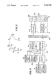
- FIG. 1 shows a section from a road network which is subdivided into meshes by covering the network with a grid;
- FIG. 2 shows a flow chart illustrating the method according to the invention
- FIG. 3 shows a vector view to illustrate the matching process
- FIG. 4 shows a block wiring diagram of an apparatus according to the invention.
- the roads are depicted as graphs, whose nodes represent the intersections k and whose edges represent the road segments g between two intersections.
- the edges are composed of straight segments g in such a way that deviations of the graph from the actual course of the road do not exceed predetermined limiting values, e.g., 10 meters, 15°.
- the graph is covered with a grid of vertical lines 26 and horizontal lines 28.
- the step size of the grid that is the distance between two grid lines 26 or 28, depends on the road density or, as expressed in terms of graphs, the edge density.
- Road density is understood to mean the number of roads per surface area unit.
- the step size can vary between 125 meters in the city center area and approximately 1000 meters in the intercity network. It is preferably selected for each area in such a way that the number of roads touching a mesh does not substantially exceed the value of 10.
- the mesh with coordinate c, number 3 contains a list of roads 30, 32, 34 and 36.
- the mesh with coordinate d, number 3 contains only the roads 32, 34 and 36.
- the relevant roads for the matching are not only determined by those meshes within which the instantaneous position of the vehicle is located.
- the mesh with coordinate c, number 3 there is the point of origin S; the roads located in the surrounding area of the selected mesh are also taken into account.
- the surrounding area is formed here by those meshes which adjoin the mesh in which the instantaneous position is located.
- eight additional meshes with coordinates b2, b3, b4, c2, c4, d2, d3 and d4 are involved.
- the region is emphasized graphically by a dash-dot border.
- the surrounding area is now formed additionally by the meshes with coordinates b1, c1 and d1, while the meshes with coordinates b4, c4 and d4 are omitted. In this way, there results a sufficiently large marginal region from which roads can be utilized for the matching, even when there is an erroneous calculation of the instantaneous position of the vehicle.
- the process for determining the position proceeds substantially as follows: first, a starting position is entered, and the mesh within which the starting position is located is determined. Proceeding from this starting position, the calculation of the instantaneous position is effected.
- the driving data which is transmitted by a driving data transmitter and from which an instantaneous position is determined first serves for this purpose. However, as the driving distance increases, this instantaneous position deviates from the actual position. Thus, a location error occurs.
- the instantaneous position is matched at predetermined intervals with the stored road network and is corrected to a position which lies on one of the roads.
- the roads utilized for the matching are located in the proximate surrounding area of the instantaneous position. These are preferably the roads situated within the mesh in which the instantaneous position lies, and the roads which are situated in the meshes surrounding the aforementioned mesh. Those roads which touch one or more of these meshes are taken into account, in addition.
- the relevant roads are then weighted according to the probability that the calculated instantaneous position is located on them.
- the road with the highest weighting is finally selected, the instantaneous position is corrected in such a way that it lies on the road, and this new position is now used as starting point for further determination of the position.
- an initialization is effected in 40. This is understood as a first-time input of the position of origin or the start position. Since no location error is present yet in this phase, the continued process can be introduced by erasing or resetting the evaluation memory for the weighting of the roads. This takes place in step 42.
- step 42 During driving, calculation of the position from the driving data is carried out in short intervals, maximum of 10 meters. This is effected in step 44.
- the calculation of position is preferably effected according to the principle of dead reckoning position finding, in which both the traveled distance and the driving direction are taken into account. A determination of the direction by means of a compass can also be utilized additionally.
- step 46 it is decided whether or not the calculated position lies in the previous mesh.
- the previous mesh is that in which the start position is located. Reference is always made to the preceding instantaneous position at every additional pass.
- the roads are then weighted in step 48 corresponding to the probability that the instantaneous position could lie on one of the roads.
- the weighting can be effected e.g. in such a way that the distance of the calculated instantaneous position is compared with the individual roads and evaluation numbers are assigned to the roads in a staggered manner according to the distance.
- the road with the smallest distance receives the highest evaluation number, that with the greatest distance receives the smallest evaluation number.
- the same process is then effected between the driving direction and the direction of the roads.
- the road whose direction agrees to the greatest extent with the driving direction receives the maximum evaluation number, that which agrees least with the driving direction receives the lowest evaluation number.
- the evaluations between the distance and direction can also be combined.
- the w is the weighting or evaluation
- ⁇ g is the direction of a straight segment of the road
- ⁇ f is the driving direction
- a is the distance between the calculated position and the road.
- step 48 After the weightings of the roads are calculated in step 48, they are added to an evaluation memory.
- the latter contains memory locations for the weightings of each of the relevant roads. The weightings are added up at every new calculation. After the calculation, it is decided, in 50, whether or not a threshold value has been reached. If this is the case, the calculated position is corrected in 52 to the road with the highest weighting. Next, the process course is continued in step 42.
- step 44 If the threshold value is not reached in 50, the process course is continued with step 44. If the calculated instantaneous position does not lie in the previous mesh, a branching off is effected in steps 46 to 54, and the list of relevant roads which are to be weighted is updated. The new roads to be added are thus first weighted, the weightings of the roads no longer under consideration are deleted, and the weightings of the roads which will continue to be taken into consideration are adopted. Next, the process step continues with step 48.
- a vehicle is to be driven from the intersection k 1 to the intersection k 2 .
- the straight segments g 1 , g 2 and g 3 are traveled.
- the determination of the position on the basis of the driving data which are supposed to be erroneous results in a virtual driving segment from the straight lines g 1' , g 2' and g 3' .
- a calculation of the instantaneous position and a weighting of the total roads g 1 -g 6 to be taken into account is effected.
- the straight line segment g 4 could receive high weighting because of the small distance or the straight line segments g 5 and g 6 could receive high weighting because of the agreement of direction.
- the end of the straight line g 3 appears as the most probable position after driving over the virtual straight line segment g 3' , and the instantaneous position is accordingly corrected to this position.
- FIG. 4 shows a block wiring diagram of the device according to the invention.
- This comprises a computer 14, to which driving data of a driving data transmitter 10 is fed via an input-output interface 56, as well as a first memory 12 for a digitized road network and a second memory 16 for a qrid network.
- a memory 58 for the operation software and a write-read memory arrangement 60 are connected with the computer 14.
- the write-read memory arrangement 60 comprises a working memory 62, a third memory 22 for an evaluation or weighting of the roads, and a fourth memory 24 for a threshold value.
- the computer is also connected, via the input-output interface 56, with a display and control element 64 which comprises a display 66 and an input keyboard 68.
- the driving data transmitter 10 particularly comprises a sensor controller 70 as well as wheel sensors 18 and a compass 20.
- the starting position is first entered in the computer 14 via the input keyboard 68.
- the driving data transmitter 10 supplies, at predetermined intervals, driving data which proceed from the wheel sensors 18 and possibly from the compass 20 and are evaluated in the computer 14 according to the principle of dead reckoning position finding.
- the instantaneous position is calculated from the driving data.
- the road network stored in the first memory and the grid network stored in the second memory are transferred to the working memory in portions until the mesh is found within which the instantaneous position is located.
- This mesh, the meshes adjoining this mesh, and the roads lying within this region are then copied into the working memory 62.
- a weighting of the relevant roads, i.e. those in the mesh in which the instantaneous position is located and roads located in the adjoining meshes, as well as the roads touching the meshes, is also carried out at every calculation of the instantaneous position.
- the results of this weighting are transferred to the third memory 22 for every road and added to the values already there.
- a comparison is made between the weightings and a threshold value stored in the fourth memory 24. This takes place in a comparator, wherein the comparator can be discretely present or can be realized by means of a corresponding control of the computer 14. If the threshold value is reached or exceeded, the computer 14 carries out a matching of the instantaneous position to the position of the most highly weighted road and erases the third memory 22.
- a very fast calculation is made possible due to the reduction, achieved with the invention, of the amount of data sufficient for this computing process. This is particularly necessary in a dense road network in a large city. If the computer determines that the vehicle approaches an intersection or fork at which the driving direction must be changed, it sends a corresponding recommendation via the display 66. These recommendations are given until the destination position is reached or a new destination position is entered.
Landscapes
- Engineering & Computer Science (AREA)
- Radar, Positioning & Navigation (AREA)
- Remote Sensing (AREA)
- Physics & Mathematics (AREA)
- General Physics & Mathematics (AREA)
- Automation & Control Theory (AREA)
- Navigation (AREA)
- Traffic Control Systems (AREA)
Applications Claiming Priority (2)
| Application Number | Priority Date | Filing Date | Title |
|---|---|---|---|
| DE19873718996 DE3718996A1 (de) | 1987-06-06 | 1987-06-06 | Verfahren und vorrichtung zur positionsbestimmung eines landfahrzeugs |
| DE3718996 | 1987-06-06 |
Publications (1)
| Publication Number | Publication Date |
|---|---|
| US5023798A true US5023798A (en) | 1991-06-11 |
Family
ID=6329199
Family Applications (1)
| Application Number | Title | Priority Date | Filing Date |
|---|---|---|---|
| US07/457,760 Expired - Lifetime US5023798A (en) | 1987-06-06 | 1988-06-04 | Method of and apparatus for determining a position of a land vehicle |
Country Status (4)
| Country | Link |
|---|---|
| US (1) | US5023798A (de) |
| EP (1) | EP0363396B1 (de) |
| DE (2) | DE3718996A1 (de) |
| WO (1) | WO1988009916A1 (de) |
Cited By (26)
| Publication number | Priority date | Publication date | Assignee | Title |
|---|---|---|---|---|
| US5184303A (en) * | 1991-02-28 | 1993-02-02 | Motorola, Inc. | Vehicle route planning system |
| US5283575A (en) * | 1991-11-08 | 1994-02-01 | Zexel Corporation | System and method for locating a travelling vehicle |
| EP0593256A1 (de) * | 1992-10-14 | 1994-04-20 | Pioneer Electronic Corporation | Navigationsvorrichtung |
| US5312169A (en) * | 1990-03-23 | 1994-05-17 | Alfred Teves Gmbh | Circuit configuration for an automotive vehicle with anti-lock control and/or traction slip control |
| US5493294A (en) * | 1992-04-15 | 1996-02-20 | Sumitomo Electric Industries, Ltd. | Apparatus for detecting the position of a vehicle |
| US5512904A (en) * | 1994-06-13 | 1996-04-30 | Andrew Corporation | Method and apparatus of establishing a vehicle azimuth |
| US5515284A (en) * | 1991-09-25 | 1996-05-07 | Zexel Corporation | Storage medium for map information for navigation system and system for offering map information for navigation system |
| WO1998011522A1 (en) * | 1996-09-16 | 1998-03-19 | Minorplanet Limited | Monitoring vehicle positions |
| WO1999001855A1 (en) * | 1997-07-02 | 1999-01-14 | Mitsubishi Denki Kabushiki Kaisha | Vehicle navigator |
| US5862511A (en) * | 1995-12-28 | 1999-01-19 | Magellan Dis, Inc. | Vehicle navigation system and method |
| US5991692A (en) * | 1995-12-28 | 1999-11-23 | Magellan Dis, Inc. | Zero motion detection system for improved vehicle navigation system |
| US6028553A (en) * | 1996-06-13 | 2000-02-22 | Siemens Aktiengesellschaft | Method for dynamic route recommendation |
| US6029111A (en) * | 1995-12-28 | 2000-02-22 | Magellan Dis, Inc. | Vehicle navigation system and method using GPS velocities |
| US6115803A (en) * | 1994-05-17 | 2000-09-05 | Fujitsu Limited | Parallel computer which verifies direct data transmission between local memories with a send complete flag |
| US6308134B1 (en) | 1996-12-27 | 2001-10-23 | Magellan Dis, Inc. | Vehicle navigation system and method using multiple axes accelerometer |
| US6374184B1 (en) * | 1999-09-10 | 2002-04-16 | Ge-Harris Railway Electronics, Llc | Methods and apparatus for determining that a train has changed paths |
| US20030165254A1 (en) * | 2002-02-15 | 2003-09-04 | International Business Machines Corporation | Adapting point geometry for storing address density |
| US20040153238A1 (en) * | 2003-01-22 | 2004-08-05 | Increment P Corporation | Data structure of feature guidance information, recording medium storing feature guidance information, navigation device, navigation system, navigation method, navigation program and recording medium storing the navigation program |
| GB2403008A (en) * | 2003-06-18 | 2004-12-22 | Infomatiq Ltd | A method of locating and aiding a pedestrian |
| US20050079877A1 (en) * | 2003-08-22 | 2005-04-14 | Fujitsu Ten Limited | Mobile object location providing device and mobile object location providing system |
| US20050258978A1 (en) * | 2002-09-12 | 2005-11-24 | Siemens Ag Osterreich | Method for identifying a toll-required section of road |
| US20060129283A1 (en) * | 2004-12-14 | 2006-06-15 | International Business Machines Corporation | Obtaining contextual vehicle information |
| US20060129309A1 (en) * | 2004-12-14 | 2006-06-15 | International Business Machines Corporation | Method and system for performing programmatic actions based upon vehicle approximate locations |
| US20060195261A1 (en) * | 2005-02-10 | 2006-08-31 | Homeland Integrated Security Systems, Inc. | Electronic device for tracking and monitoring assets |
| US20120277993A1 (en) * | 2009-10-22 | 2012-11-01 | Heiko Mund | Incremental map generation, refinement and extension with gps traces |
| USRE44925E1 (en) | 1995-01-31 | 2014-06-03 | Transcenic, Inc. | Spatial referenced photographic system with navigation arrangement |
Families Citing this family (5)
| Publication number | Priority date | Publication date | Assignee | Title |
|---|---|---|---|---|
| DE4028214C2 (de) * | 1990-09-06 | 1996-05-30 | Nuclear Cargo & Service Gmbh | Verfahren zur Umsetzung von in Werten eines geographischen Koordinatensystems erzeugten Standortdaten in eine auf einem karthesischen Koordinatensystem beruhende Rasterform |
| DE59407782D1 (de) * | 1993-11-26 | 1999-03-18 | Mannesmann Ag | Einrichtung in einem fahrzeug zur feststellung des betretens einer teilstrecke eines vorgegebenen strassennetzes |
| DE19835051A1 (de) * | 1998-08-04 | 2000-02-10 | Bosch Gmbh Robert | Einrichtung zur Codierung und zur Decodierung von Orten |
| DE10114412C5 (de) * | 2001-03-23 | 2006-07-06 | Audi Ag | Verfahren zur Erzeugung einer Straßennetzkarte sowie Verfahren und Vorrichtung zur Steuerung von Fahrzeugsystemen in einem Fahrzeug |
| CN108364456B (zh) * | 2018-01-12 | 2021-03-09 | 山东高速信息工程有限公司 | 一种确定高速公路桩号的方法、存储介质、装置及系统 |
Citations (4)
| Publication number | Priority date | Publication date | Assignee | Title |
|---|---|---|---|---|
| US4796191A (en) * | 1984-06-07 | 1989-01-03 | Etak, Inc. | Vehicle navigational system and method |
| US4897792A (en) * | 1987-09-29 | 1990-01-30 | Pioneer Electronic Corporation | Method of memorizing travel locus data for use in an automotive navigation system |
| US4924402A (en) * | 1986-07-02 | 1990-05-08 | Pioneer Electronic Corporation | Method for identifying current position of vehicle |
| US4937572A (en) * | 1985-04-27 | 1990-06-26 | Nippondenso Co., Ltd. | Map display apparatus storing data of physically adjacent map sections in physically adjacent storage locations |
Family Cites Families (3)
| Publication number | Priority date | Publication date | Assignee | Title |
|---|---|---|---|---|
| US3789198A (en) * | 1972-04-10 | 1974-01-29 | Boeing Co | Vehicle location monitoring system |
| GB1470694A (en) * | 1974-06-08 | 1977-04-21 | Marconi Co Ltd | Vehicle location systems |
| GB2139794A (en) * | 1983-05-09 | 1984-11-14 | Hubert Ralph Waldo Rabson | Comprehensive road direction indicators |
-
1987
- 1987-06-06 DE DE19873718996 patent/DE3718996A1/de not_active Withdrawn
-
1988
- 1988-06-04 WO PCT/DE1988/000332 patent/WO1988009916A1/de not_active Ceased
- 1988-06-04 DE DE8888904498T patent/DE3866356D1/de not_active Expired - Lifetime
- 1988-06-04 US US07/457,760 patent/US5023798A/en not_active Expired - Lifetime
- 1988-06-04 EP EP19880904498 patent/EP0363396B1/de not_active Expired - Lifetime
Patent Citations (4)
| Publication number | Priority date | Publication date | Assignee | Title |
|---|---|---|---|---|
| US4796191A (en) * | 1984-06-07 | 1989-01-03 | Etak, Inc. | Vehicle navigational system and method |
| US4937572A (en) * | 1985-04-27 | 1990-06-26 | Nippondenso Co., Ltd. | Map display apparatus storing data of physically adjacent map sections in physically adjacent storage locations |
| US4924402A (en) * | 1986-07-02 | 1990-05-08 | Pioneer Electronic Corporation | Method for identifying current position of vehicle |
| US4897792A (en) * | 1987-09-29 | 1990-01-30 | Pioneer Electronic Corporation | Method of memorizing travel locus data for use in an automotive navigation system |
Non-Patent Citations (2)
| Title |
|---|
| "Car-Guide-on-Board Computer for Automobiles", 1984, pp. 697-706, National Computer Conference, 364/449. |
| Car Guide on Board Computer for Automobiles , 1984, pp. 697 706, National Computer Conference, 364/449. * |
Cited By (41)
| Publication number | Priority date | Publication date | Assignee | Title |
|---|---|---|---|---|
| US5312169A (en) * | 1990-03-23 | 1994-05-17 | Alfred Teves Gmbh | Circuit configuration for an automotive vehicle with anti-lock control and/or traction slip control |
| US5184303A (en) * | 1991-02-28 | 1993-02-02 | Motorola, Inc. | Vehicle route planning system |
| US5515284A (en) * | 1991-09-25 | 1996-05-07 | Zexel Corporation | Storage medium for map information for navigation system and system for offering map information for navigation system |
| US5283575A (en) * | 1991-11-08 | 1994-02-01 | Zexel Corporation | System and method for locating a travelling vehicle |
| US5493294A (en) * | 1992-04-15 | 1996-02-20 | Sumitomo Electric Industries, Ltd. | Apparatus for detecting the position of a vehicle |
| EP0593256A1 (de) * | 1992-10-14 | 1994-04-20 | Pioneer Electronic Corporation | Navigationsvorrichtung |
| US6115803A (en) * | 1994-05-17 | 2000-09-05 | Fujitsu Limited | Parallel computer which verifies direct data transmission between local memories with a send complete flag |
| US5512904A (en) * | 1994-06-13 | 1996-04-30 | Andrew Corporation | Method and apparatus of establishing a vehicle azimuth |
| USRE44925E1 (en) | 1995-01-31 | 2014-06-03 | Transcenic, Inc. | Spatial referenced photographic system with navigation arrangement |
| US6029111A (en) * | 1995-12-28 | 2000-02-22 | Magellan Dis, Inc. | Vehicle navigation system and method using GPS velocities |
| US5862511A (en) * | 1995-12-28 | 1999-01-19 | Magellan Dis, Inc. | Vehicle navigation system and method |
| US5991692A (en) * | 1995-12-28 | 1999-11-23 | Magellan Dis, Inc. | Zero motion detection system for improved vehicle navigation system |
| US6028553A (en) * | 1996-06-13 | 2000-02-22 | Siemens Aktiengesellschaft | Method for dynamic route recommendation |
| AU713178B2 (en) * | 1996-09-16 | 1999-11-25 | Minorplanet Limited | Monitoring vehicle positions |
| US6285953B1 (en) | 1996-09-16 | 2001-09-04 | Minorplant Limited | Monitoring vehicle positions |
| WO1998011522A1 (en) * | 1996-09-16 | 1998-03-19 | Minorplanet Limited | Monitoring vehicle positions |
| US6308134B1 (en) | 1996-12-27 | 2001-10-23 | Magellan Dis, Inc. | Vehicle navigation system and method using multiple axes accelerometer |
| US6282493B1 (en) | 1997-07-02 | 2001-08-28 | Mitsubishi Denki Kabushiki Kaisha | Vehicle navigation device |
| WO1999001855A1 (en) * | 1997-07-02 | 1999-01-14 | Mitsubishi Denki Kabushiki Kaisha | Vehicle navigator |
| US6374184B1 (en) * | 1999-09-10 | 2002-04-16 | Ge-Harris Railway Electronics, Llc | Methods and apparatus for determining that a train has changed paths |
| US7046827B2 (en) * | 2002-02-15 | 2006-05-16 | International Business Machines Corporation | Adapting point geometry for storing address density |
| US20030165254A1 (en) * | 2002-02-15 | 2003-09-04 | International Business Machines Corporation | Adapting point geometry for storing address density |
| US7324017B2 (en) | 2002-09-12 | 2008-01-29 | Siemens Ag Osterreich | Method for identifying a toll-required section of road |
| US20050258978A1 (en) * | 2002-09-12 | 2005-11-24 | Siemens Ag Osterreich | Method for identifying a toll-required section of road |
| US20040153238A1 (en) * | 2003-01-22 | 2004-08-05 | Increment P Corporation | Data structure of feature guidance information, recording medium storing feature guidance information, navigation device, navigation system, navigation method, navigation program and recording medium storing the navigation program |
| US7451040B2 (en) * | 2003-01-22 | 2008-11-11 | Increment Corporation | Data structure of feature guidance information, recording medium storing feature guidance information, navigation device, navigation system, navigation method, navigation program and recording medium storing the navigation program |
| GB2403008A (en) * | 2003-06-18 | 2004-12-22 | Infomatiq Ltd | A method of locating and aiding a pedestrian |
| US20050079877A1 (en) * | 2003-08-22 | 2005-04-14 | Fujitsu Ten Limited | Mobile object location providing device and mobile object location providing system |
| US7761228B2 (en) | 2003-08-22 | 2010-07-20 | Fujitsu Ten Limited | Mobile object location providing device and mobile object location providing system |
| US20090125231A1 (en) * | 2003-08-22 | 2009-05-14 | Fujitsu Ten Limited | Mobile object location providing device and mobile object location providing system |
| US7480563B2 (en) * | 2003-08-22 | 2009-01-20 | Fujitsu Ten Limited | Mobile object location providing device and mobile object location providing system |
| US20060129283A1 (en) * | 2004-12-14 | 2006-06-15 | International Business Machines Corporation | Obtaining contextual vehicle information |
| US20090150070A1 (en) * | 2004-12-14 | 2009-06-11 | International Business Machines Corporation | Method and system for performing programmatic actions based upon vehicle appropximate locations |
| US7212916B2 (en) | 2004-12-14 | 2007-05-01 | International Business Machines Corporation | Obtaining contextual vehicle information |
| US7912630B2 (en) | 2004-12-14 | 2011-03-22 | International Business Machines Corporation | Method and system for performing programmatic actions based upon vehicle approximate locations |
| US20060129309A1 (en) * | 2004-12-14 | 2006-06-15 | International Business Machines Corporation | Method and system for performing programmatic actions based upon vehicle approximate locations |
| US20060195261A1 (en) * | 2005-02-10 | 2006-08-31 | Homeland Integrated Security Systems, Inc. | Electronic device for tracking and monitoring assets |
| US20120277993A1 (en) * | 2009-10-22 | 2012-11-01 | Heiko Mund | Incremental map generation, refinement and extension with gps traces |
| US9322660B2 (en) * | 2009-10-22 | 2016-04-26 | Tomtom Germany Gmbh & Co. Kg | Incremental map generation, refinement and extension with GPS traces |
| US20160238396A1 (en) * | 2009-10-22 | 2016-08-18 | Tomtom Global Content B.V. | Incremental map generation, refinement and extension with gps traces |
| US10001378B2 (en) * | 2009-10-22 | 2018-06-19 | Tomtom Global Contect B.V. | Incremental map generation, refinement and extension with GPS traces |
Also Published As
| Publication number | Publication date |
|---|---|
| WO1988009916A1 (fr) | 1988-12-15 |
| DE3718996A1 (de) | 1988-12-22 |
| DE3866356D1 (de) | 1992-01-02 |
| EP0363396B1 (de) | 1991-11-21 |
| EP0363396A1 (de) | 1990-04-18 |
Similar Documents
| Publication | Publication Date | Title |
|---|---|---|
| US5023798A (en) | Method of and apparatus for determining a position of a land vehicle | |
| US7512489B2 (en) | Route search method and traffic information display method for a navigation device | |
| KR100281293B1 (ko) | 차량 항법 시스템의 경로 결정 방법 | |
| KR100493092B1 (ko) | 네비게이션장치 및 네비게이션장치의 최적경로 계산방법 | |
| JP4661439B2 (ja) | 車両用ナビゲーション装置及び道路地図配信システム | |
| US8515655B2 (en) | Navigation device and method for route calculation | |
| US6549844B1 (en) | Method for navigating a vehicle | |
| US8213682B2 (en) | Feature information collecting apparatuses, methods, and programs | |
| CN114430801B (zh) | 地形敏感的路线规划 | |
| US20240410710A1 (en) | Method, apparatus, and computer program product for generation of a route including multiple waypoints | |
| JP4450000B2 (ja) | 経路選択支援装置および経路選択支援方法 | |
| US11543259B2 (en) | Determining landmark detectability | |
| US20210215495A1 (en) | Analysis of network effects of avoidance areas on routing | |
| JP2007127439A (ja) | ナビゲーション装置 | |
| Blazquez et al. | Simple map-matching algorithm applied to intelligent winter maintenance vehicle data | |
| EP3865821B1 (de) | Verfahren und systeme zur ermittlung eines sicheren rückgabebereichs | |
| CN113447035B (zh) | 用于生成停车场几何结构的方法、设备和计算机程序产品 | |
| US7844393B2 (en) | Vehicle navigation system and method | |
| US8494769B2 (en) | Information system, terminal device, and information center device | |
| US12215985B1 (en) | Offline registration of elements between maps | |
| US9829328B2 (en) | Method and apparatus for route calculation involving freeway junction | |
| US11315425B2 (en) | History information storage apparatus, route calculation method, and influence range distribution system | |
| JP2544855B2 (ja) | 車両誘導装置 | |
| JP5276922B2 (ja) | 現在位置算出装置 | |
| WO2007091496A1 (ja) | 位置表示装置、位置表示方法、位置表示プログラムおよび記録媒体 |
Legal Events
| Date | Code | Title | Description |
|---|---|---|---|
| AS | Assignment |
Owner name: ROBERT BOSCH GMBH, POSTFACH 10 60 50, D-7000 STUTT Free format text: ASSIGNMENT OF ASSIGNORS INTEREST.;ASSIGNORS:NEUKIRCHNER, ERNST-PETER;SCHLOGL, DIETMAR;REEL/FRAME:005646/0571 Effective date: 19890928 |
|
| STCF | Information on status: patent grant |
Free format text: PATENTED CASE |
|
| FEPP | Fee payment procedure |
Free format text: PAYOR NUMBER ASSIGNED (ORIGINAL EVENT CODE: ASPN); ENTITY STATUS OF PATENT OWNER: LARGE ENTITY |
|
| FPAY | Fee payment |
Year of fee payment: 4 |
|
| FEPP | Fee payment procedure |
Free format text: PAYOR NUMBER ASSIGNED (ORIGINAL EVENT CODE: ASPN); ENTITY STATUS OF PATENT OWNER: LARGE ENTITY Free format text: PAYER NUMBER DE-ASSIGNED (ORIGINAL EVENT CODE: RMPN); ENTITY STATUS OF PATENT OWNER: LARGE ENTITY |
|
| FPAY | Fee payment |
Year of fee payment: 8 |
|
| REMI | Maintenance fee reminder mailed | ||
| FPAY | Fee payment |
Year of fee payment: 12 |