US4970696A - Method for conducting three-dimensional subsurface and marine seismic surveys - Google Patents
Method for conducting three-dimensional subsurface and marine seismic surveys Download PDFInfo
- Publication number
- US4970696A US4970696A US07/495,250 US49525090A US4970696A US 4970696 A US4970696 A US 4970696A US 49525090 A US49525090 A US 49525090A US 4970696 A US4970696 A US 4970696A
- Authority
- US
- United States
- Prior art keywords
- seismic
- orthogonally
- uniform pattern
- conducting
- locations
- Prior art date
- Legal status (The legal status is an assumption and is not a legal conclusion. Google has not performed a legal analysis and makes no representation as to the accuracy of the status listed.)
- Expired - Lifetime
Links
Images


Classifications
-
- G—PHYSICS
- G01—MEASURING; TESTING
- G01V—GEOPHYSICS; GRAVITATIONAL MEASUREMENTS; DETECTING MASSES OR OBJECTS; TAGS
- G01V1/00—Seismology; Seismic or acoustic prospecting or detecting
- G01V1/003—Seismic data acquisition in general, e.g. survey design
Definitions
- This invention relates in general to methods for conducting subsurface and marine seismic surveys and in particular to methods particularly suited for conducting three-dimensional subsurface and marine seismic surveys.
- a second alternative method is referred to as the "swath" technique.
- This approach utilizes several parallel lines of receivers separated by a distance greater than the in-line receiver interval.
- a series of seismic waves are imparted into the receiver configuration in an in-line or split spread manner.
- fairly uniform offset information is provided along the center line of the swath; however, the outer line have considerably less uniform offset distributions.
- Shotpoint movement is limited in this technique to directions parallel to the receiver lines (to avoid driving over receiver lines), therefore a minimal amount of azimuthal information is acquired. This is further complicated by the fact that virtually all of the azimuthal data acquired have very short shot-receiver offsets.
- noises commonly called ground roll. These noises are not as common in marine surveys, but do exist and must be considered especially in shallow water. Additionally, noise may be created by scattered reflections from subsea irregularities such as islands or mounds. These are described in a paper by Larner et al. 1983, “Coherent Noise In Marine Seismic Data,” Geophysics, Volume 488 pp. 854-886.
- the method of the present invention utilizes a plurality of seismic receivers which are arranged in multiple orthogonally uniform patterns.
- a predetermined pattern of shotpoints is arranged such that every point in the subsurface area of interest is sampled over a desired range of offsets and azimuths.
- the utilization of shotpoints outside the pattern of receivers allows examination of a subsurface area greater than the area of the pattern itself.
- the output of each receiver in the pattern is simultaneously recorded for each series of seismic waves applied to the surface of the earth. Where the area of interest in quite large, a multitude of patterns of seismic receivers may be utilized to ensure coverage of the entire area.
- a plurality of seismic receivers are arranged in an orthogonally uniform pattern by utilizing multiple parallel marine streamers towed by one or more recorder boats or placed on the bottom, by cable, anchors or divers.
- One or more source boats are then utilized to produce a plurality of shotpoints such that every point in the subsurface area of interest is sample over desired range of offsets and azimuths.
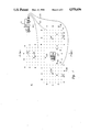
- FIG. 1 is a schematic representation of a surface view of the seismic exploration method of the present invention
- FIG. 2 is a sectional view of the seismic exploration method of the present invention taken along line 2--2 of FIG. 1;
- FIG. 3 is a schematic representation of a surface view of the seismic exploration method of the present invention in a marine environment using streamers.
- FIG. 1 there is depicted a schematic representation of a surface view of the seismic exploration method of the present invention.
- a survey is being conducted over a portion of the surface of the earth 10.
- Multiple patterns of seismic receivers 12, 14 and 16 are utilized in conjunction with the method of the present invention, each pattern consisting of an orthogonally uniform distribution of geophone groups which are preferably disposed on an orthogonal grid having uniformly distributed vertices.
- these vertices are preferably at least ten feet apart and preferably less than one thousand feet apart.
- patterns 12, 14 and 16 do not necessarily overlap, as depicted.
- obstacles such as building or oil producing facility 34 maybe placed into a gap in the patterns of the survey.
- the present invention it will then be possible with the present invention to adjust the so-called "shotpoints" or sites of seismic wave application to accommodate these obstacles without causing a gap in the seismic survey.
- each seismic receiver or geophone in pattern 12, 14 or 16 is coupled via optical or electrical transmission lines, or a suitable telemetry system to a recording truck 18.
- each pattern is coupled to recording truck 18 by a data line, such as data lines 20, 22 and 24 respectively.
- each orthogonally uniform pattern 12, 14 and 16 is preferably disposed about a selected point on the earth's surface. That is, pattern 12 is disposed about point 42, pattern 14 is disposed about point 44 and pattern 16 is disposed about point 46.
- pattern 12 is disposed about point 42
- pattern 14 is disposed about point 44
- pattern 16 is disposed about point 46.
- shotspoints is extended to include the utilization of modern vibrational sources.
- a plurality of shotpoints 26 are then selected, each of which is located at a different distance and azimuth from the selected point for each particular pattern.
- At least one shotpoint may be located adjacent to pattern 12, 14 or 16. That is, shotpoint 28 is located adjacent to pattern 12, shotpoint 30 is located adjacent to pattern 16.
- This feature of the present invention is made possible due to the existence of large open areas between the patterns and the utilization of shotpoints between the patterns make is possible to acquire near offset data from each of these source positions which can dramatically improve the accuracy of the various processing techniques which are ultilized.
- far and middle offset data may be determined during the utilization of shotpoints which are disposed further outside of each pattern.
- FIG. 1 The technique described above and illustrated in FIG. 1 is equally applicable to marine three-dimensional seismic surveys with the receiver patterns placed on the bottom of a body of water or suspended above the bottom with the seismic sources either on the bottom or towed through the body of water.
- FIG. 2 there is depicted a sectional view of the seismic exploration method of the present invention taken along line 2-2 of FIG. 1.
- an obstacle such as oil producing facility 34
- careful consideration of the placement of shotpoints 26 to obtain the desired offset and azimuth make it possible to accurately survey an area of subsurface formation 40 which may greatly exceed that the area of pattern 12.
- the presence of an obstacle such as oil producing facility 34 need no longer have the effect of causing a skip or blank within the survey obtained since the method of the present invention permits planning of the placement of each individual pattern to accommodate such obstacles.
- FIG. 3 there is depicted a schematic representation of a surface view of the seismic exploration method of the present invention in a marine environment.
- a survey is conducted over a portion of the surface of a body of water 50.
- a pattern 52 of seismic receivers is utilized in conjunction with the method of the present invention.
- Pattern 52 comprises an orthogonally uniform distribution of hydrophones 62 which are preferably disposed on an orthogonal grid having uniformly distributed vertices.
- this orthogonally uniform distribution is accomplished utilizing a plurality of marine streamers 54 which are towed behind a recording boat 56.
- Each streamer 54 is depicted as towed behind a paravane 58; however, those skilled in the art will appreciate that small drone crafts or semisubmersibles may also be utilized to tow multiple streamers 54.
- each streamer 54 comprises a relatively short marine streamer of approximately 1500 meters in length and streamers 54 are preferably separated by a distance of approximately 25 meters.
- Each streamer 54 preferably has a 25 m group interval requiring a 240 to 480 channel recording system.
- Recording boat 56 will preferably traverse a predetermined course at a relatively slow speed, such as three to four knots, and will carry all required recording equipment.
- a plurality of seismic waves are imparted into the earth at a plurality of location which are disposed at variable distances and azimuths from a selected point from within pattern 52.
- the fact the pattern 52 is moving slowly will require some offset calculation; however, this is a trivial matter which may be simply determined.
- seismic waves are generated, in a conventional manner, utilizing a plurality of small source boats 64, 66 and 68 which each traverse a predetermined track and fire an air gun or other seismic source at a plurality of shotpoints 70.
- the use of multiple source boats traversing the area of various angles with respect to the track of recording boat 56 will provide an azimuthal distribution of data while also achieving a desirable offset distribution. Since the source and recording receivers are towed by different boats lower fold data may be collected while maintaining an excellent signal-to-noise ratio.
- certain shotpoints 70 may be located within pattern 52, permitting near offset data to be acquired, thereby improving the accuracy of the processing technique.
- source boats 64, 66 and 68 may simply be implemented utilizing any available boat since the source boats do not require recording instrumentation. Further, since the source intervals for each source boat may be larger, less compressor capacity is required, allowing the utilization of smaller boats. Since small source boats are utilized which do not tow marine streamers, the source boats may move more quickly from shotpoint to shotpoint allowing rapid positioning for seismic surveys.
- the method of the present invention provides an operator with the ability to obtain a true three-dimensional seismic survey, due to the wide range of offsets and azimuths which are sampled, by utilizing a well designed survey in accordance with the teaching of the present invention. Further, the method of the present invention permits the operator to adjust the range of offset and azimuths which will be acquired to meet practical geophysical or economic constraints. For example, in those cases where the subsurface structures and velocities are not complex or wherein the exploration budget will not permit detailed surveying, it is possible to design a survey which provides only the information necessary to produce a focussed image.
- An additional advantage of the present invention is that the uniform sampling intervals provided by the mutually orthogonal pattern of seismic receivers make it possible to use processing techniques to attenuate unwanted coherent noise trains.
- the uniform sampling provided in accordance with the present invention in two orthogonal directions makes it possible to characterize these noises accurately in both time and space. In this manner it is possible to design a filter to effectively attenuate these noises.
- the uniform orthogonal pattern of seismic receivers utilized in the present invention makes it possible to sample the velocity field within the earth's surface in three dimesions in order to derive estimates of the three-dimensional velocity field from the data obtained. Previously known techniques have only allowed the inference of the three-dimensional velocity field from two orthogonal velocity estimates.
- the utilization of the spaces available within each seismic receiver pattern make it possible to occupy shotpoints within the pattern to provide near offset data.
- the areal distribution of the shotpoints utilized in this technique provides a wide variety of azimuthally distributed information which is not typically obtained with known "pseudo" three-dimensional techniques.
Abstract
A method for conducting a three-dimensional subsurface seismic survey utilizing a plurality of seismic receivers arranged in an orthogonally uniform pattern is disclosed. A predetermined pattern of shotpoints is arranged such that every point in the surface area of interest is sampled over a desired range of offsets and a full range of azimuths. The utilization of shotpoints outside the pattern of receivers allows examination of a subsurface area which is greater than the area of the pattern itself. The output of each receiver in the pattern is simultaneously recorded for seismic energy applied to the surface of the earth. Where the area of interest is quite large, a multitude of patterns of seismic receivers may be utilized to ensure coverage of the entire area. In a marine application of the present invention a plurality of seismic receivers are arranged in an orthogonally uniform pattern under a body of water or by utilizing multiple parallel marine streamers towed by one or more tow boats. One or more source boats are then utilized to produce a plurality of shotpoints such that every point in the subsurface area of interest is sampled over a desired range of offsets and azimuths.
Description
The present invention is a continuation-in-part of U.S. patent application Ser. No. 07/218,662, filed Jul. 13, 1988, entitled "Method for Conducting Three-Dimensional Subsurface Seismic Surveys, " now U.S. Pat. No. 4,930,110.
1. Field of the Invention:
This invention relates in general to methods for conducting subsurface and marine seismic surveys and in particular to methods particularly suited for conducting three-dimensional subsurface and marine seismic surveys.
2. Description of the Prior Art:
The concept of three-dimensional seismic surveying is well known in the prior art. Heretofor, in order to accurately construct an image of an unknown subsurface structure in three dimensions, without introducing a directional bias to the data, each common reflection point must be sampled from a large number of azimuths and distances or "offsets". This is generally accomplished by taking repetitive measurements and utilizing statistical processing methods to focus the image. The small channel recording systems currently available do not readily permit the sampling necessary to accomplish three-dimensional surveying without the necessity of adding shotpoints, repetitively moving the receivers, and/or repeatedly driving the seismic sources over the recording equipment to obtain the necessary azimuths and offsets. In view of the difficulty in obtaining these measurements several alternative methods have been proposed.
One such alternative method is the so-called "seisloop" method. This method utilizes deploying the availabe seismic receivers in a loop and imparting seismic waves or "shooting" wherever possible around the loop. This technique provides reasonable azimuthal information; however, offset information is generally limited in most areas of the survey.
A second alternative method is referred to as the "swath" technique. This approach utilizes several parallel lines of receivers separated by a distance greater than the in-line receiver interval. A series of seismic waves are imparted into the receiver configuration in an in-line or split spread manner. In this manner, fairly uniform offset information is provided along the center line of the swath; however, the outer line have considerably less uniform offset distributions. Shotpoint movement is limited in this technique to directions parallel to the receiver lines (to avoid driving over receiver lines), therefore a minimal amount of azimuthal information is acquired. This is further complicated by the fact that virtually all of the azimuthal data acquired have very short shot-receiver offsets.
In land surveys the designer of three-dimensional surveys must be concerned with noises commonly called ground roll. These noises are not as common in marine surveys, but do exist and must be considered especially in shallow water. Additionally, noise may be created by scattered reflections from subsea irregularities such as islands or mounds. These are described in a paper by Larner et al. 1983, "Coherent Noise In Marine Seismic Data," Geophysics, Volume 488 pp. 854-886.
As noted above, each of the aforementioned techniques suffer certain defects and it may also be shown that neither of the above-referenced methods can provide the uniform lateral sampling necessary to properly sample coherent noises or the information coupling between the source, receiver and substance to allow adequate processing. Therefore, it should be appararent that a need exists for an improved seismic survey method which can be utilized to obtain three-dimensional subsurface seismic surveys.
It is therefore one object of the present invention to provide an improved seismic survey method.
It is another object of the present invention to provide an improved seismic survey method which provides improved azimuthal and offset information.
It is yet another object of the present invention to provide an improved seismic survey method which provides uniform lateral sampling so that out-of-plane coherent noise may be properly sampled.
The foregiong objects are achieved as is now described. The method of the present invention utilizes a plurality of seismic receivers which are arranged in multiple orthogonally uniform patterns. A predetermined pattern of shotpoints is arranged such that every point in the subsurface area of interest is sampled over a desired range of offsets and azimuths. The utilization of shotpoints outside the pattern of receivers allows examination of a subsurface area greater than the area of the pattern itself. The output of each receiver in the pattern is simultaneously recorded for each series of seismic waves applied to the surface of the earth. Where the area of interest in quite large, a multitude of patterns of seismic receivers may be utilized to ensure coverage of the entire area. In a marine application of the present invention a plurality of seismic receivers are arranged in an orthogonally uniform pattern by utilizing multiple parallel marine streamers towed by one or more recorder boats or placed on the bottom, by cable, anchors or divers. One or more source boats are then utilized to produce a plurality of shotpoints such that every point in the subsurface area of interest is sample over desired range of offsets and azimuths.
The above as well as additional objects, features, and advantages of the invention will become apparent in the following detailed description.
The novel features believed characteristic of the invention are set forth in the appended claims. The invention itself; however, as well as a preferred mode of use, further objects and advantages thereof, will best be understood by reference to the following detailed description of an illustrative embodiment when read in conjunction with the accompanying drawings, wherein:
FIG. 1 is a schematic representation of a surface view of the seismic exploration method of the present invention;
FIG. 2 is a sectional view of the seismic exploration method of the present invention taken along line 2--2 of FIG. 1; and
FIG. 3 is a schematic representation of a surface view of the seismic exploration method of the present invention in a marine environment using streamers.
With reference now to the figures and in particular with reference to FIG. 1, there is depicted a schematic representation of a surface view of the seismic exploration method of the present invention. As can be seen, a survey is being conducted over a portion of the surface of the earth 10. Multiple patterns of seismic receivers 12, 14 and 16 are utilized in conjunction with the method of the present invention, each pattern consisting of an orthogonally uniform distribution of geophone groups which are preferably disposed on an orthogonal grid having uniformly distributed vertices. In a preferred embodiment of the present invention, these vertices are preferably at least ten feet apart and preferably less than one thousand feet apart.
In accordance with one aspect of the present invention, patterns 12, 14 and 16 do not necessarily overlap, as depicted. In this manner, obstacles such as building or oil producing facility 34 maybe placed into a gap in the patterns of the survey. As will be apparent upon reference to the present invention, it will then be possible with the present invention to adjust the so-called "shotpoints" or sites of seismic wave application to accommodate these obstacles without causing a gap in the seismic survey.
As is typical in known seismic survey systems, each seismic receiver or geophone in pattern 12, 14 or 16 is coupled via optical or electrical transmission lines, or a suitable telemetry system to a recording truck 18. In the depicted embodiment, each pattern is coupled to recording truck 18 by a data line, such as data lines 20, 22 and 24 respectively. Thus, it is possible to simultaneously record the responses of each seismic receiver in one or more pattern during seismic exploration.
Still referring to FIG. 1, it can be seen that each orthogonally uniform pattern 12, 14 and 16 is preferably disposed about a selected point on the earth's surface. That is, pattern 12 is disposed about point 42, pattern 14 is disposed about point 44 and pattern 16 is disposed about point 46. Next, for each pattern in the survey at least one seismic wave is imparted into the earth at a plurality of locations which are all located at variable distances and azimuths from the aforementioned selected points. As utilized herein the term "shotpoints" is extended to include the utilization of modern vibrational sources. As can be seen, a plurality of shotpoints 26 are then selected, each of which is located at a different distance and azimuth from the selected point for each particular pattern.
In accordance with still another aspect of the present invention, it can be seen that at least one shotpoint may be located adjacent to pattern 12, 14 or 16. That is, shotpoint 28 is located adjacent to pattern 12, shotpoint 30 is located adjacent to pattern 16. This feature of the present invention is made possible due to the existence of large open areas between the patterns and the utilization of shotpoints between the patterns make is possible to acquire near offset data from each of these source positions which can dramatically improve the accuracy of the various processing techniques which are ultilized. Of course, far and middle offset data may be determined during the utilization of shotpoints which are disposed further outside of each pattern.
The technique described above and illustrated in FIG. 1 is equally applicable to marine three-dimensional seismic surveys with the receiver patterns placed on the bottom of a body of water or suspended above the bottom with the seismic sources either on the bottom or towed through the body of water.
Referring now to FIG. 2, there is depicted a sectional view of the seismic exploration method of the present invention taken along line 2-2 of FIG. 1. In this manner, it can be seen that it is possible to obtain a seismic survey of subsurface strata beneath an obstacle such as oil producing facility 34 without the necessity of placing a pattern of geophones within the space occupied by the obstacle. As can be seen, careful consideration of the placement of shotpoints 26 to obtain the desired offset and azimuth make it possible to accurately survey an area of subsurface formation 40 which may greatly exceed that the area of pattern 12. Thus, the presence of an obstacle such as oil producing facility 34 need no longer have the effect of causing a skip or blank within the survey obtained since the method of the present invention permits planning of the placement of each individual pattern to accommodate such obstacles.
With reference now to FIG. 3 there is depicted a schematic representation of a surface view of the seismic exploration method of the present invention in a marine environment. As may be seen, a survey is conducted over a portion of the surface of a body of water 50. A pattern 52 of seismic receivers is utilized in conjunction with the method of the present invention. Pattern 52 comprises an orthogonally uniform distribution of hydrophones 62 which are preferably disposed on an orthogonal grid having uniformly distributed vertices. In a preferred embodiment of the present invention this orthogonally uniform distribution is accomplished utilizing a plurality of marine streamers 54 which are towed behind a recording boat 56. Each streamer 54 is depicted as towed behind a paravane 58; however, those skilled in the art will appreciate that small drone crafts or semisubmersibles may also be utilized to tow multiple streamers 54.
While paravanes 58 or other means may be utilized to ensure uniform spacing between each streamer 54, those skilled in this art will appreciate that a plurality of spacer 60 may also be utilized to ensure uniform spacing of streamers 54. In a preferred embodiment of the present invention each streamer 54 comprises a relatively short marine streamer of approximately 1500 meters in length and streamers 54 are preferably separated by a distance of approximately 25 meters. Each streamer 54 preferably has a 25 m group interval requiring a 240 to 480 channel recording system. Recording boat 56 will preferably traverse a predetermined course at a relatively slow speed, such as three to four knots, and will carry all required recording equipment.
Next, as discussed above with respect to FIG. 1, a plurality of seismic waves are imparted into the earth at a plurality of location which are disposed at variable distances and azimuths from a selected point from within pattern 52. Of course, the fact the pattern 52 is moving slowly will require some offset calculation; however, this is a trivial matter which may be simply determined.
As illustrated, seismic waves are generated, in a conventional manner, utilizing a plurality of small source boats 64, 66 and 68 which each traverse a predetermined track and fire an air gun or other seismic source at a plurality of shotpoints 70. The use of multiple source boats traversing the area of various angles with respect to the track of recording boat 56 will provide an azimuthal distribution of data while also achieving a desirable offset distribution. Since the source and recording receivers are towed by different boats lower fold data may be collected while maintaining an excellent signal-to-noise ratio. Also, as discussed above, certain shotpoints 70 may be located within pattern 52, permitting near offset data to be acquired, thereby improving the accuracy of the processing technique.
Another advantage of the marine embodiment of the present invention is the fact that source boats 64, 66 and 68 may simply be implemented utilizing any available boat since the source boats do not require recording instrumentation. Further, since the source intervals for each source boat may be larger, less compressor capacity is required, allowing the utilization of smaller boats. Since small source boats are utilized which do not tow marine streamers, the source boats may move more quickly from shotpoint to shotpoint allowing rapid positioning for seismic surveys.
Upon reference to the foregoing specification, those skilled in the art will appreciate that the method of the present invention provides an operator with the ability to obtain a true three-dimensional seismic survey, due to the wide range of offsets and azimuths which are sampled, by utilizing a well designed survey in accordance with the teaching of the present invention. Further, the method of the present invention permits the operator to adjust the range of offset and azimuths which will be acquired to meet practical geophysical or economic constraints. For example, in those cases where the subsurface structures and velocities are not complex or wherein the exploration budget will not permit detailed surveying, it is possible to design a survey which provides only the information necessary to produce a focussed image.
An additional advantage of the present invention is that the uniform sampling intervals provided by the mutually orthogonal pattern of seismic receivers make it possible to use processing techniques to attenuate unwanted coherent noise trains. Where the intervals between seismic receivers are sufficiently small to avoid aliasing of the noises, the uniform sampling provided in accordance with the present invention in two orthogonal directions makes it possible to characterize these noises accurately in both time and space. In this manner it is possible to design a filter to effectively attenuate these noises. Similarly, the uniform orthogonal pattern of seismic receivers utilized in the present invention makes it possible to sample the velocity field within the earth's surface in three dimesions in order to derive estimates of the three-dimensional velocity field from the data obtained. Previously known techniques have only allowed the inference of the three-dimensional velocity field from two orthogonal velocity estimates.
Finally, as discussed for the land technique above, the utilization of the spaces available within each seismic receiver pattern make it possible to occupy shotpoints within the pattern to provide near offset data. Additionally, in both the land and marine case, the areal distribution of the shotpoints utilized in this technique provides a wide variety of azimuthally distributed information which is not typically obtained with known "pseudo" three-dimensional techniques.
Although the invention has been described with reference to a specific embodiment, this description is not meant to be construed in a limiting sense. Various modifications of the disclosed embodiment as well as alternative embodiments of the invention will become apparent to persons skilled in the art upon reference to the description of the invention. It is therefore contemplated that the appended claims will cover any such modifications or embodiments that fall within the true scope of the invention.
Claims (10)
1. A method for conducting three-dimensional marine seismic surveys comprising the steps of:
towing a plurality of seismic receivers along a first predetermined track in an orthogonally uniform pattern within a body of water wherein gaps are formed within said orthogonally uniform pattern;
imparting seismic energy into the earth at a plurality of locations, each of said locations disposed in a particular azimuthal direction and a selected distance from said orthogonally uniform pattern;
simultaneously recording the responses of each of said plurality of seismic receivers to said seismic energy imparted at each of said plurality of locations;
characterizing the time spatial nature of unwanted noise within said recorded responses by utilizing the uniform sampling intervals provided by said orthogonally uniform pattern; and
processing said recorded responses to remove said characterized unwanted noise.
2. The method of conducting three-dimensional marine seismic surveys according to claim 1 further including the step of imparting seismic energy into the earth at a selected location within said orthogonally uniform pattern wherein near offset data may be obtained.
3. The method for conducting three-dimensional marine seismic surveys according to claim 1 wherein said step of imparting seismic energy into the earth at a plurality of locations, each of said locations disposed in a particular azimuthal direction and a selected distance from said orthogonally uniform pattern comprises the step of traversing a second predetermined track with a seismic source boat while selectively activating said seismic source.
4. The method for conducting three-dimensional marine seismic surveys according to claim 1 wherein said step of imparting seismic energy into the earth at a plurality of locations, each of said location disposed in a particular azimuthal direction and a selected distance from said orthogonally uniform pattern comprises the step of traversing multiple predetermined tracks with a plurality of seismic source boats while selectively activating said seismic sources.
5. The method for conducting three-dimensional marine seismic surveys according to claim 1 wherein said step of towing a plurality of seismic receivers along a first predetermined track in an orthogonally uniform pattern within a body of water comprises the step of towing a plurality of marine streamers along multiple predetermined parallel tracks.
6. A method for conducting three-dimensional marine seismic surveys comprising the steps of:
situating a plurality of seismic recievers in an orthogonally uniform pattern under the surface of a body of water wherein gaps are formed within said orthogonally uniform pattern;
imparting seismic energy into the earth at a plurality of locations, each of said locations disposed in a particular azimuthal direction and a selected distance from said orthogonally uniform pattern;
simultaneously recording the responses of each of said plurality of seismic receivers to said seismic energy imparted at each of said plurality of locations;
characterizing the time spatial nature of unwanted noise within said recorded responses by utilizing the uniform sampling intervals provided by said orthogonally uniform pattern; and
processing said recorded responses to remove said characterized unwanted noise.
7. The method for conducting three-dimensional marine seismic surveys according to claim 6 further including the step of imparting seismic energy into the earth at a selected location within said orthogonally uniform pattern wherein near offset data may be obtained.
8. The method for conducting three-dimensional marine seismic surveys according to claim 6 wherein said step of imparting seismic energy into the earth at a plurality of locations, each of said locations disposed in a particular azimuthal direction and a selected distance from said orthogonally uniform pattern comprises the step of traversing a predetermined track with a seismic source boat while selectively activating said seismic source.
9. The method for conducting three-dimensional marine seismic surveys according to claim 6 wherein said step of imparting seismic energy into the earth at a plurality of locations, each of said locations disposed in a particular azimuthal direction and a selected distance from said orthogonally uniform pattern comprises the step of traversing multiple predetermined tracks with a plurality of seismic source boats while selectively activating said seismic sources.
10. The method for conducting three-dimensional marine seismic surveys according to claim 1 wherein said step of situating a plurality of seismic receivers along a predetermined track in an orthogonally uniform pattern under the surface of a body of water comprises the step of towing a plurality of marine streamers under the surface of said body of water along multiple predetermined parallel tracks.
Priority Applications (1)
| Application Number | Priority Date | Filing Date | Title |
|---|---|---|---|
| US07/495,250 US4970696A (en) | 1988-07-13 | 1990-03-16 | Method for conducting three-dimensional subsurface and marine seismic surveys |
Applications Claiming Priority (2)
| Application Number | Priority Date | Filing Date | Title |
|---|---|---|---|
| US07/218,662 US4930110A (en) | 1988-07-13 | 1988-07-13 | Method for conducting three-dimensional subsurface seismic surveys |
| US07/495,250 US4970696A (en) | 1988-07-13 | 1990-03-16 | Method for conducting three-dimensional subsurface and marine seismic surveys |
Related Parent Applications (1)
| Application Number | Title | Priority Date | Filing Date |
|---|---|---|---|
| US07/218,662 Continuation-In-Part US4930110A (en) | 1988-07-13 | 1988-07-13 | Method for conducting three-dimensional subsurface seismic surveys |
Publications (1)
| Publication Number | Publication Date |
|---|---|
| US4970696A true US4970696A (en) | 1990-11-13 |
Family
ID=26913127
Family Applications (1)
| Application Number | Title | Priority Date | Filing Date |
|---|---|---|---|
| US07/495,250 Expired - Lifetime US4970696A (en) | 1988-07-13 | 1990-03-16 | Method for conducting three-dimensional subsurface and marine seismic surveys |
Country Status (1)
| Country | Link |
|---|---|
| US (1) | US4970696A (en) |
Cited By (46)
| Publication number | Priority date | Publication date | Assignee | Title |
|---|---|---|---|---|
| US5113377A (en) * | 1991-05-08 | 1992-05-12 | Atlantic Richfield Company | Receiver array system for marine seismic surveying |
| US5257241A (en) * | 1991-05-08 | 1993-10-26 | Atlantic Richfield Company | Method and system for acquisition of 3-dimensional marine seismic data |
| US5353223A (en) * | 1992-10-26 | 1994-10-04 | Western Atlas International, Inc. | Marine navigation method for geophysical exploration |
| US5430689A (en) * | 1991-07-03 | 1995-07-04 | Atlantic Richfield Company | Method for acquiring marine seismic data having statistically distributed azimuths and offsets |
| WO1996033425A1 (en) * | 1995-04-18 | 1996-10-24 | Western Atlas International, Inc. | Uniform subsurface coverage at steep dips |
| WO1998007050A1 (en) * | 1996-08-12 | 1998-02-19 | Petroleum Geo-Services (Us), Inc. | Single vessel dragged array system and method for operation |
| US5724241A (en) * | 1996-01-11 | 1998-03-03 | Western Atlas International, Inc. | Distributed seismic data-gathering system |
| WO1998019181A1 (en) * | 1996-10-29 | 1998-05-07 | Pgs Exploration (Us), Inc. | Method and system for increasing fold to streamer length ratio |
| US5761153A (en) * | 1996-06-27 | 1998-06-02 | Input/Output, Inc. | Method of locating hydrophones |
| US5771202A (en) * | 1990-05-22 | 1998-06-23 | Geco A.S. | Method for acquisition of seismic data at sea |
| US5924049A (en) * | 1995-04-18 | 1999-07-13 | Western Atlas International, Inc. | Methods for acquiring and processing seismic data |
| US6061301A (en) * | 1997-06-30 | 2000-05-09 | Atlantic Richfield Company | Filtering of overburden azimuthal anisotropy effects from 3D seismic survey signals |
| US6553315B2 (en) * | 1997-10-15 | 2003-04-22 | Albin K. Kerekes | Seismic imaging using omni-azimuth seismic energy sources and directional sensing |
| WO2003075039A1 (en) * | 2002-03-07 | 2003-09-12 | Sverre Planke | Apparatus for seismic measurements |
| US6681184B2 (en) | 2001-05-15 | 2004-01-20 | Input/Output, Inc. | System for estimating azimuthal variations in seismic data |
| US20040027920A1 (en) * | 2002-08-08 | 2004-02-12 | Cipolla Kimberly M. | Hydraulic activated spreader arm aperture generation system |
| GB2424275A (en) * | 2005-02-10 | 2006-09-20 | Westerngeco Seismic Holdings | Apparatus and methods for seismic streamer positioning |
| GB2431237A (en) * | 2005-10-14 | 2007-04-18 | Statoil Asa | Marine seismic data acquisition with short streamers |
| US20070159921A1 (en) * | 2005-12-12 | 2007-07-12 | Carl Regone | Method of wide azimuth seismic aquisition |
| US20070165486A1 (en) * | 2006-01-19 | 2007-07-19 | Nicolae Moldoveanu | Methods and systems for efficiently acquiring towed streamer seismic surveys |
| GB2438079A (en) * | 2006-05-11 | 2007-11-14 | Westerngeco Seismic Holdings | Removing noise signals from marine seismic data |
| US20070272473A1 (en) * | 2003-12-15 | 2007-11-29 | Herkenhoff E F | Methods for acquiring and processing seismic data from quasi-simultaneously activated translating energy sources |
| US20080285381A1 (en) * | 2007-05-17 | 2008-11-20 | Nicolae Moldoveanu | Methods for Efficiently Acquiring Wide-Azimuth Towed Streamer Seismic Data |
| US20090122640A1 (en) * | 2007-05-17 | 2009-05-14 | David Ian Hill | Acquiring azimuth rich seismic data in the marine environment using a regular sparse pattern of continuously curved sail lines |
| US20100016801A1 (en) * | 2008-07-16 | 2010-01-21 | Interrad Medical, Inc. | Anchor Systems and Methods |
| US20100142317A1 (en) * | 2008-05-15 | 2010-06-10 | Nicolae Moldoveanu | Multi-vessel coil shooting acquisition |
| US20100302900A1 (en) * | 2009-05-26 | 2010-12-02 | Pgs Geophysical As | Autonomously operated marine seismic acquisition system |
| US20110158042A1 (en) * | 2009-12-30 | 2011-06-30 | Nicolae Moldoveanu | Randomization of Data Acquisition in Marine Seismic and Electromagnetic Acquisition |
| US8483008B2 (en) | 2008-11-08 | 2013-07-09 | Westerngeco L.L.C. | Coil shooting mode |
| US20130272090A1 (en) * | 2012-04-16 | 2013-10-17 | Pgs Geophysical As | Towing Methods and Systems for Geophysical Surveys |
| CN103675893A (en) * | 2012-09-04 | 2014-03-26 | 中国石油天然气集团公司 | Full-coverage laying method for complex template of offshore towrope observing system |
| US8711654B2 (en) | 2009-12-30 | 2014-04-29 | Westerngeco L.L.C. | Random sampling for geophysical acquisitions |
| US8724426B2 (en) | 2008-06-03 | 2014-05-13 | Westerngeco L.L.C. | Marine seismic streamer system configurations, systems, and methods for non-linear seismic survey navigation |
| US20140160887A1 (en) * | 2004-05-21 | 2014-06-12 | Westerngeco L.L.C. | Time lapse marine seismic surveying employing interpolated multicomponent streamer pressure data |
| WO2013189989A3 (en) * | 2012-06-20 | 2014-07-31 | Seabird Exploration Norway As | Seismic cable and modular seismic system |
| US9001615B2 (en) | 2011-11-08 | 2015-04-07 | Conocophillips Company | Oscillating flared streamers |
| US9052411B2 (en) | 2008-06-13 | 2015-06-09 | Westerngeco L.L.C. | Method to determine the deviation of seismic equipment from a planned curved path |
| US9103942B2 (en) | 2011-10-28 | 2015-08-11 | Westerngeco L.L.C. | Methods and systems for survey designs |
| US9594181B2 (en) | 2008-06-13 | 2017-03-14 | Westerngeco L.L.C. | Filtering and presentation of heading observations for coil shooting |
| US9857491B2 (en) | 2008-05-15 | 2018-01-02 | Westerngeco L.L.C. | Multi-vessel coil shooting acquisition |
| CN108375788A (en) * | 2018-02-12 | 2018-08-07 | 中国地质大学(北京) | A kind of quick seismic data acquisition device of travelling |
| US10120087B2 (en) | 2014-01-21 | 2018-11-06 | Cgg Services Sas | Method and system with low-frequency seismic source |
| US20190064380A1 (en) * | 2017-08-29 | 2019-02-28 | Pgs Geophysical As | Seismic data acquisition for velocity modeling and imaging |
| USRE47389E1 (en) * | 2009-12-30 | 2019-05-14 | Westerngeco, L.L.C. | Method and apparatus for acquiring wide-azimuth marine data using simultaneous shooting |
| US10795041B2 (en) | 2012-10-16 | 2020-10-06 | Conocophillips Company | Flared pseudo-random spiral marine acquisition |
| US20220041259A1 (en) * | 2020-08-07 | 2022-02-10 | Ion Geophysical Corporation | Control system for steerable towed marine equipment |
Citations (10)
| Publication number | Priority date | Publication date | Assignee | Title |
|---|---|---|---|---|
| US2336053A (en) * | 1940-03-11 | 1943-12-07 | Continental Oil Co | Method of making geophysical explorations |
| US3431999A (en) * | 1967-04-26 | 1969-03-11 | Exxon Production Research Co | Common depth point seismic prospecting |
| US3753222A (en) * | 1970-05-22 | 1973-08-14 | Texas Instruments Inc | Three dimensional common depth point exploration |
| US3934220A (en) * | 1973-07-03 | 1976-01-20 | Avance Oil & Gas Company, Inc. | Method of seismic exploration for penetrating diffraction barriers and/or surveying beneath obstacles |
| US4001770A (en) * | 1974-06-17 | 1977-01-04 | Texas Instruments Incorporated | Roll-a-long three-dimensional common depth point exploration |
| US4403312A (en) * | 1980-12-30 | 1983-09-06 | Mobil Oil Corporation | Three-dimensional seismic data gathering method |
| US4476555A (en) * | 1980-09-12 | 1984-10-09 | Sony Corporation | Tracking servo apparatus for an optical information reproducing system |
| US4567582A (en) * | 1982-07-06 | 1986-01-28 | Phillips Petroleum Company | Direct determination of stacking velocities in three dimensional seismic prospecting |
| US4677598A (en) * | 1983-03-25 | 1987-06-30 | Standard Oil Company (Indiana) | Seismic data acquisition method |
| US4930110A (en) * | 1988-07-13 | 1990-05-29 | Atlantic Richfield Company | Method for conducting three-dimensional subsurface seismic surveys |
-
1990
- 1990-03-16 US US07/495,250 patent/US4970696A/en not_active Expired - Lifetime
Patent Citations (10)
| Publication number | Priority date | Publication date | Assignee | Title |
|---|---|---|---|---|
| US2336053A (en) * | 1940-03-11 | 1943-12-07 | Continental Oil Co | Method of making geophysical explorations |
| US3431999A (en) * | 1967-04-26 | 1969-03-11 | Exxon Production Research Co | Common depth point seismic prospecting |
| US3753222A (en) * | 1970-05-22 | 1973-08-14 | Texas Instruments Inc | Three dimensional common depth point exploration |
| US3934220A (en) * | 1973-07-03 | 1976-01-20 | Avance Oil & Gas Company, Inc. | Method of seismic exploration for penetrating diffraction barriers and/or surveying beneath obstacles |
| US4001770A (en) * | 1974-06-17 | 1977-01-04 | Texas Instruments Incorporated | Roll-a-long three-dimensional common depth point exploration |
| US4476555A (en) * | 1980-09-12 | 1984-10-09 | Sony Corporation | Tracking servo apparatus for an optical information reproducing system |
| US4403312A (en) * | 1980-12-30 | 1983-09-06 | Mobil Oil Corporation | Three-dimensional seismic data gathering method |
| US4567582A (en) * | 1982-07-06 | 1986-01-28 | Phillips Petroleum Company | Direct determination of stacking velocities in three dimensional seismic prospecting |
| US4677598A (en) * | 1983-03-25 | 1987-06-30 | Standard Oil Company (Indiana) | Seismic data acquisition method |
| US4930110A (en) * | 1988-07-13 | 1990-05-29 | Atlantic Richfield Company | Method for conducting three-dimensional subsurface seismic surveys |
Non-Patent Citations (2)
| Title |
|---|
| Larner et al., "Coherent Noise In Marine Leisure Data"; Geophysics, vol. 48, No. 7, 7/83, pp. 854-886. |
| Larner et al., Coherent Noise In Marine Leisure Data ; Geophysics, vol. 48, No. 7, 7/83, pp. 854 886. * |
Cited By (80)
| Publication number | Priority date | Publication date | Assignee | Title |
|---|---|---|---|---|
| US5771202A (en) * | 1990-05-22 | 1998-06-23 | Geco A.S. | Method for acquisition of seismic data at sea |
| US5113377A (en) * | 1991-05-08 | 1992-05-12 | Atlantic Richfield Company | Receiver array system for marine seismic surveying |
| US5257241A (en) * | 1991-05-08 | 1993-10-26 | Atlantic Richfield Company | Method and system for acquisition of 3-dimensional marine seismic data |
| US5430689A (en) * | 1991-07-03 | 1995-07-04 | Atlantic Richfield Company | Method for acquiring marine seismic data having statistically distributed azimuths and offsets |
| US5353223A (en) * | 1992-10-26 | 1994-10-04 | Western Atlas International, Inc. | Marine navigation method for geophysical exploration |
| WO1996033425A1 (en) * | 1995-04-18 | 1996-10-24 | Western Atlas International, Inc. | Uniform subsurface coverage at steep dips |
| US5717655A (en) * | 1995-04-18 | 1998-02-10 | Western Atlas International, Inc. | Method for providing uniform subsurface coverage in the presence of steep dips |
| US5924049A (en) * | 1995-04-18 | 1999-07-13 | Western Atlas International, Inc. | Methods for acquiring and processing seismic data |
| US5724241A (en) * | 1996-01-11 | 1998-03-03 | Western Atlas International, Inc. | Distributed seismic data-gathering system |
| US5761153A (en) * | 1996-06-27 | 1998-06-02 | Input/Output, Inc. | Method of locating hydrophones |
| WO1998007050A1 (en) * | 1996-08-12 | 1998-02-19 | Petroleum Geo-Services (Us), Inc. | Single vessel dragged array system and method for operation |
| US5761152A (en) * | 1996-10-29 | 1998-06-02 | Pgs Exploration (Us), Inc. | Method and system for increasing fold to streamer length ratio |
| WO1998019181A1 (en) * | 1996-10-29 | 1998-05-07 | Pgs Exploration (Us), Inc. | Method and system for increasing fold to streamer length ratio |
| US6061301A (en) * | 1997-06-30 | 2000-05-09 | Atlantic Richfield Company | Filtering of overburden azimuthal anisotropy effects from 3D seismic survey signals |
| US6553315B2 (en) * | 1997-10-15 | 2003-04-22 | Albin K. Kerekes | Seismic imaging using omni-azimuth seismic energy sources and directional sensing |
| US6681184B2 (en) | 2001-05-15 | 2004-01-20 | Input/Output, Inc. | System for estimating azimuthal variations in seismic data |
| US20040109387A1 (en) * | 2001-05-15 | 2004-06-10 | Jenner Edward Louis | System for estimating azimuthal variations in seismic data |
| US6898147B2 (en) | 2001-05-15 | 2005-05-24 | Input/Output, Inc. | System for estimating azimuthal variations in seismic data |
| GB2401684A (en) * | 2002-03-07 | 2004-11-17 | Sverre Planke | Apparatus for seismic measurements |
| GB2401684B (en) * | 2002-03-07 | 2005-07-27 | Sverre Planke | Apparatus for seismic measurements |
| US20050180260A1 (en) * | 2002-03-07 | 2005-08-18 | Sverre Planke | Apparatus for seismic measurements |
| WO2003075039A1 (en) * | 2002-03-07 | 2003-09-12 | Sverre Planke | Apparatus for seismic measurements |
| US7221620B2 (en) | 2002-03-07 | 2007-05-22 | Sverre Planke | Apparatus for seismic measurements |
| US20040027920A1 (en) * | 2002-08-08 | 2004-02-12 | Cipolla Kimberly M. | Hydraulic activated spreader arm aperture generation system |
| US6766755B2 (en) * | 2002-08-08 | 2004-07-27 | The United States Of America As Represented By The Secretary Of The Navy | Hydraulic activated spreader arm aperture generation system |
| US7679990B2 (en) * | 2003-12-15 | 2010-03-16 | Chevron U.S.A. Inc. | Methods for acquiring and processing seismic data from quasi-simultaneously activated translating energy sources |
| US20070272473A1 (en) * | 2003-12-15 | 2007-11-29 | Herkenhoff E F | Methods for acquiring and processing seismic data from quasi-simultaneously activated translating energy sources |
| US20140160887A1 (en) * | 2004-05-21 | 2014-06-12 | Westerngeco L.L.C. | Time lapse marine seismic surveying employing interpolated multicomponent streamer pressure data |
| GB2424275B (en) * | 2005-02-10 | 2008-10-01 | Westerngeco Seismic Holdings | Apparatus and methods for seismic streamer positioning |
| GB2424275A (en) * | 2005-02-10 | 2006-09-20 | Westerngeco Seismic Holdings | Apparatus and methods for seismic streamer positioning |
| GB2431237A (en) * | 2005-10-14 | 2007-04-18 | Statoil Asa | Marine seismic data acquisition with short streamers |
| US20070159921A1 (en) * | 2005-12-12 | 2007-07-12 | Carl Regone | Method of wide azimuth seismic aquisition |
| US7391673B2 (en) * | 2005-12-12 | 2008-06-24 | Bp Corporation North America Inc. | Method of wide azimuth seismic acquisition |
| US20100027374A1 (en) * | 2006-01-19 | 2010-02-04 | Westerngeco, L.L.C. | Methods and Systems for Efficiently Acquiring Towed Streamer Seismic Surveys |
| US20080267010A1 (en) * | 2006-01-19 | 2008-10-30 | Westerngeco L. L. C. | Methods and Systems for Efficiently Acquiring Towed Streamer Seismic Surveys |
| US20070165486A1 (en) * | 2006-01-19 | 2007-07-19 | Nicolae Moldoveanu | Methods and systems for efficiently acquiring towed streamer seismic surveys |
| AU2006252148B2 (en) * | 2006-01-19 | 2009-05-14 | Westerngeco Seismic Holdings Limited | Methods and systems for efficiently acquiring towed streamer seismic surveys |
| US8760964B2 (en) | 2006-01-19 | 2014-06-24 | Westerngeco L.L.C. | Methods and systems for efficiently acquiring towed streamer seismic surveys |
| US9869787B2 (en) | 2006-01-19 | 2018-01-16 | Westerngeco L.L.C. | Methods and systems for efficiently acquiring towed streamer seismic surveys |
| US7400552B2 (en) * | 2006-01-19 | 2008-07-15 | Westerngeco L.L.C. | Methods and systems for efficiently acquiring towed streamer seismic surveys |
| GB2438079A (en) * | 2006-05-11 | 2007-11-14 | Westerngeco Seismic Holdings | Removing noise signals from marine seismic data |
| GB2438079B (en) * | 2006-05-11 | 2010-12-08 | Westerngeco Seismic Holdings | Method and apparatus for marine seismic data acquistion |
| US8559265B2 (en) | 2007-05-17 | 2013-10-15 | Westerngeco L.L.C. | Methods for efficiently acquiring wide-azimuth towed streamer seismic data |
| US8908469B2 (en) * | 2007-05-17 | 2014-12-09 | Westerngeco L.L.C. | Acquiring azimuth rich seismic data in the marine environment using a regular sparse pattern of continuously curved sail lines |
| US20090122640A1 (en) * | 2007-05-17 | 2009-05-14 | David Ian Hill | Acquiring azimuth rich seismic data in the marine environment using a regular sparse pattern of continuously curved sail lines |
| US20080285381A1 (en) * | 2007-05-17 | 2008-11-20 | Nicolae Moldoveanu | Methods for Efficiently Acquiring Wide-Azimuth Towed Streamer Seismic Data |
| US20130301384A1 (en) * | 2007-05-17 | 2013-11-14 | Westerngeco L.L.C. | Acquiring azimuth rich seismic data in the marine environment using a regular sparse pattern of continuously curved sail lines |
| US8488409B2 (en) | 2007-05-17 | 2013-07-16 | Westerngeco L.L.C. | Acquiring azimuth rich seismic data in the marine environment using a regular sparse pattern of continuously curved sail lines |
| US9766359B2 (en) | 2008-05-15 | 2017-09-19 | Westerngeco L.L.C. | Multi-vessel coil shooting acquisition |
| US9703000B2 (en) | 2008-05-15 | 2017-07-11 | Westerngeco L.L.C. | Multi-vessel coil shooting acquisition |
| US8681580B2 (en) | 2008-05-15 | 2014-03-25 | Westerngeco L.L.C. | Multi-vessel coil shooting acquisition |
| US9857491B2 (en) | 2008-05-15 | 2018-01-02 | Westerngeco L.L.C. | Multi-vessel coil shooting acquisition |
| US20100142317A1 (en) * | 2008-05-15 | 2010-06-10 | Nicolae Moldoveanu | Multi-vessel coil shooting acquisition |
| US8724426B2 (en) | 2008-06-03 | 2014-05-13 | Westerngeco L.L.C. | Marine seismic streamer system configurations, systems, and methods for non-linear seismic survey navigation |
| US9052411B2 (en) | 2008-06-13 | 2015-06-09 | Westerngeco L.L.C. | Method to determine the deviation of seismic equipment from a planned curved path |
| US9594181B2 (en) | 2008-06-13 | 2017-03-14 | Westerngeco L.L.C. | Filtering and presentation of heading observations for coil shooting |
| US10082589B2 (en) | 2008-06-13 | 2018-09-25 | Westerngeco L.L.C. | Method to determine the deviation of seismic equipment from a planned curved path |
| US20100016801A1 (en) * | 2008-07-16 | 2010-01-21 | Interrad Medical, Inc. | Anchor Systems and Methods |
| US8483008B2 (en) | 2008-11-08 | 2013-07-09 | Westerngeco L.L.C. | Coil shooting mode |
| WO2010138149A1 (en) * | 2009-05-26 | 2010-12-02 | Pgs Geophysical As | Autonomously operated marine seismic acquisition system |
| US20100302900A1 (en) * | 2009-05-26 | 2010-12-02 | Pgs Geophysical As | Autonomously operated marine seismic acquisition system |
| US20110158042A1 (en) * | 2009-12-30 | 2011-06-30 | Nicolae Moldoveanu | Randomization of Data Acquisition in Marine Seismic and Electromagnetic Acquisition |
| US8711654B2 (en) | 2009-12-30 | 2014-04-29 | Westerngeco L.L.C. | Random sampling for geophysical acquisitions |
| USRE47389E1 (en) * | 2009-12-30 | 2019-05-14 | Westerngeco, L.L.C. | Method and apparatus for acquiring wide-azimuth marine data using simultaneous shooting |
| US8681581B2 (en) | 2009-12-30 | 2014-03-25 | Westerngeco L.L.C. | Randomization of data acquisition in marine seismic and electromagnetic acquisition |
| US9103942B2 (en) | 2011-10-28 | 2015-08-11 | Westerngeco L.L.C. | Methods and systems for survey designs |
| US9001615B2 (en) | 2011-11-08 | 2015-04-07 | Conocophillips Company | Oscillating flared streamers |
| US9217806B2 (en) * | 2012-04-16 | 2015-12-22 | Pgs Geophysical As | Towing methods and systems for geophysical surveys |
| US20130272090A1 (en) * | 2012-04-16 | 2013-10-17 | Pgs Geophysical As | Towing Methods and Systems for Geophysical Surveys |
| WO2013189989A3 (en) * | 2012-06-20 | 2014-07-31 | Seabird Exploration Norway As | Seismic cable and modular seismic system |
| CN103675893B (en) * | 2012-09-04 | 2016-08-03 | 中国石油天然气集团公司 | Full-coverage laying method for complex template of offshore towrope observing system |
| CN103675893A (en) * | 2012-09-04 | 2014-03-26 | 中国石油天然气集团公司 | Full-coverage laying method for complex template of offshore towrope observing system |
| US10795041B2 (en) | 2012-10-16 | 2020-10-06 | Conocophillips Company | Flared pseudo-random spiral marine acquisition |
| US10120087B2 (en) | 2014-01-21 | 2018-11-06 | Cgg Services Sas | Method and system with low-frequency seismic source |
| US20190064380A1 (en) * | 2017-08-29 | 2019-02-28 | Pgs Geophysical As | Seismic data acquisition for velocity modeling and imaging |
| GB2606450A (en) * | 2017-08-29 | 2022-11-09 | Pgs Geophysical As | Seismic data acquisition for velocity modeling and imaging |
| GB2606450B (en) * | 2017-08-29 | 2023-02-08 | Pgs Geophysical As | Seismic data acquisition for velocity modeling and imaging |
| US11747500B2 (en) * | 2017-08-29 | 2023-09-05 | Pgs Geophysical As | Seismic data acquisition for velocity modeling and imaging |
| CN108375788A (en) * | 2018-02-12 | 2018-08-07 | 中国地质大学(北京) | A kind of quick seismic data acquisition device of travelling |
| US20220041259A1 (en) * | 2020-08-07 | 2022-02-10 | Ion Geophysical Corporation | Control system for steerable towed marine equipment |
Similar Documents
| Publication | Publication Date | Title |
|---|---|---|
| US4970696A (en) | Method for conducting three-dimensional subsurface and marine seismic surveys | |
| Gabriels et al. | In situ measurements of shear‐wave velocity in sediments with higher‐mode Rayleigh waves | |
| US6493636B1 (en) | Method of marine seismic exploration utilizing vertically and horizontally offset streamers | |
| US5257241A (en) | Method and system for acquisition of 3-dimensional marine seismic data | |
| US9310503B2 (en) | Methods to process seismic data contaminated by coherent energy radiated from more than one source | |
| US9575196B2 (en) | Coherent noise attenuation | |
| Chen et al. | Subsurface imaging using reversed vertical seismic profiling and crosshole tomographic methods | |
| US20050219949A1 (en) | Method for detecting earth formation fractures by seismic imaging of diffractors | |
| US9651691B2 (en) | Methods and systems for land seismic surveying | |
| US3934220A (en) | Method of seismic exploration for penetrating diffraction barriers and/or surveying beneath obstacles | |
| CA2176058C (en) | Three-dimensional seismic acquisition | |
| US20240012169A1 (en) | Hybrid ocean bottom seismic receiver and streamer seismic data acquisition using wide towed sources | |
| GB2488652A (en) | Method for alternating depths of streamers and sources during marine seismic acquisition | |
| EP0988563B1 (en) | Method for sorting seismic data | |
| US20010005813A1 (en) | 3-D seismic trace extrapolation and interpolation | |
| GB2589011A (en) | Modified simultaneous long-offset acquistion with improved low frequency performance for full wavefield inversion | |
| US4930110A (en) | Method for conducting three-dimensional subsurface seismic surveys | |
| EP3341757B1 (en) | Nodal hybrid gather | |
| US20200393590A1 (en) | Low frequency acquisition with towed streamers | |
| US4783770A (en) | Method of three-component reflection seismology | |
| GB2180341A (en) | Method of acquiring and processing seismic energy signals and marine seismic array | |
| US20230184979A1 (en) | Continuous seismic data acquisition having variable density source geometry | |
| US20230184978A1 (en) | Continuous seismic data acquisition having variable density source geometry | |
| Talagapu | 2d and 3d land seismic data acquisition and seismic data processing | |
| Regone et al. | Identifying, quantifying, and suppressing backscattered seismic noise |
Legal Events
| Date | Code | Title | Description |
|---|---|---|---|
| AS | Assignment |
Owner name: ATLANTIC RICHFIELD COMPANY, CALIFORNIA Free format text: ASSIGNMENT OF ASSIGNORS INTEREST.;ASSIGNORS:CREWS, GARY A.;MUSSER, JAMES A.;REEL/FRAME:005255/0424 Effective date: 19900315 |
|
| STCF | Information on status: patent grant |
Free format text: PATENTED CASE |
|
| FEPP | Fee payment procedure |
Free format text: PAYOR NUMBER ASSIGNED (ORIGINAL EVENT CODE: ASPN); ENTITY STATUS OF PATENT OWNER: LARGE ENTITY |
|
| FPAY | Fee payment |
Year of fee payment: 4 |
|
| FPAY | Fee payment |
Year of fee payment: 8 |
|
| FPAY | Fee payment |
Year of fee payment: 12 |