US20180098137A1 - Method and system for utility power lines vegetation proximity monitoring and controlling - Google Patents
Method and system for utility power lines vegetation proximity monitoring and controlling Download PDFInfo
- Publication number
- US20180098137A1 US20180098137A1 US15/330,978 US201715330978A US2018098137A1 US 20180098137 A1 US20180098137 A1 US 20180098137A1 US 201715330978 A US201715330978 A US 201715330978A US 2018098137 A1 US2018098137 A1 US 2018098137A1
- Authority
- US
- United States
- Prior art keywords
- vegetation
- data
- sensor
- electric
- power line
- Prior art date
- Legal status (The legal status is an assumption and is not a legal conclusion. Google has not performed a legal analysis and makes no representation as to the accuracy of the status listed.)
- Granted
Links
Images

Classifications
-
- H—ELECTRICITY
- H04—ELECTRIC COMMUNICATION TECHNIQUE
- H04Q—SELECTING
- H04Q9/00—Arrangements in telecontrol or telemetry systems for selectively calling a substation from a main station, in which substation desired apparatus is selected for applying a control signal thereto or for obtaining measured values therefrom
-
- G—PHYSICS
- G06—COMPUTING OR CALCULATING; COUNTING
- G06Q—INFORMATION AND COMMUNICATION TECHNOLOGY [ICT] SPECIALLY ADAPTED FOR ADMINISTRATIVE, COMMERCIAL, FINANCIAL, MANAGERIAL OR SUPERVISORY PURPOSES; SYSTEMS OR METHODS SPECIALLY ADAPTED FOR ADMINISTRATIVE, COMMERCIAL, FINANCIAL, MANAGERIAL OR SUPERVISORY PURPOSES, NOT OTHERWISE PROVIDED FOR
- G06Q10/00—Administration; Management
- G06Q10/06—Resources, workflows, human or project management; Enterprise or organisation planning; Enterprise or organisation modelling
- G06Q10/063—Operations research, analysis or management
- G06Q10/0631—Resource planning, allocation, distributing or scheduling for enterprises or organisations
- G06Q10/06316—Sequencing of tasks or work
-
- G—PHYSICS
- G06—COMPUTING OR CALCULATING; COUNTING
- G06Q—INFORMATION AND COMMUNICATION TECHNOLOGY [ICT] SPECIALLY ADAPTED FOR ADMINISTRATIVE, COMMERCIAL, FINANCIAL, MANAGERIAL OR SUPERVISORY PURPOSES; SYSTEMS OR METHODS SPECIALLY ADAPTED FOR ADMINISTRATIVE, COMMERCIAL, FINANCIAL, MANAGERIAL OR SUPERVISORY PURPOSES, NOT OTHERWISE PROVIDED FOR
- G06Q10/00—Administration; Management
- G06Q10/06—Resources, workflows, human or project management; Enterprise or organisation planning; Enterprise or organisation modelling
- G06Q10/063—Operations research, analysis or management
- G06Q10/0635—Risk analysis of enterprise or organisation activities
-
- G—PHYSICS
- G06—COMPUTING OR CALCULATING; COUNTING
- G06Q—INFORMATION AND COMMUNICATION TECHNOLOGY [ICT] SPECIALLY ADAPTED FOR ADMINISTRATIVE, COMMERCIAL, FINANCIAL, MANAGERIAL OR SUPERVISORY PURPOSES; SYSTEMS OR METHODS SPECIALLY ADAPTED FOR ADMINISTRATIVE, COMMERCIAL, FINANCIAL, MANAGERIAL OR SUPERVISORY PURPOSES, NOT OTHERWISE PROVIDED FOR
- G06Q10/00—Administration; Management
- G06Q10/20—Administration of product repair or maintenance
-
- G—PHYSICS
- G06—COMPUTING OR CALCULATING; COUNTING
- G06Q—INFORMATION AND COMMUNICATION TECHNOLOGY [ICT] SPECIALLY ADAPTED FOR ADMINISTRATIVE, COMMERCIAL, FINANCIAL, MANAGERIAL OR SUPERVISORY PURPOSES; SYSTEMS OR METHODS SPECIALLY ADAPTED FOR ADMINISTRATIVE, COMMERCIAL, FINANCIAL, MANAGERIAL OR SUPERVISORY PURPOSES, NOT OTHERWISE PROVIDED FOR
- G06Q50/00—Information and communication technology [ICT] specially adapted for implementation of business processes of specific business sectors, e.g. utilities or tourism
- G06Q50/06—Energy or water supply
-
- H—ELECTRICITY
- H04—ELECTRIC COMMUNICATION TECHNIQUE
- H04Q—SELECTING
- H04Q2209/00—Arrangements in telecontrol or telemetry systems
- H04Q2209/80—Arrangements in the sub-station, i.e. sensing device
- H04Q2209/84—Measuring functions
Definitions
- Electric utility overhead transmission (bulk and local systems) and distribution power lines/wires/conductors are carried on metallic and nonmetallic towers and poles across very long distances in many directions which include metropolitan, urban, suburban and rural areas. Vegetation/trees from the surroundings can potentially encroach in to the overhead high voltage (4 kilo volt [kV] and above) electric lines, eventually contacting or striking these lines. These vegetation encroachment events may bring the energized lines down to the ground, ignite surrounding vegetation and cause unscheduled electric service disruptions (blackouts). These hazards are amplified in drought seasons when dead trees in the proximity of the utility power lines could fall over these high voltage electric conductors and start wildfire.
- kV kilo volt
- the utilities and/or power lines maintenance companies need to cyclically inspect these power lines to monitor and assess vegetation conditions and mitigate hazards from potential vegetation encroachments. Based on the vegetation condition inspection findings, the power line vegetation maintenance crews cut/trim or remove vegetation/trees that reach a threshold proximity to the power lines as predefined by the relevant regulatory agencies and utility companies. There are federal, state, regional, and local level regulatory agencies to oversea this vegetation management compliance process in the United Sates. A few examples of such regulatory agencies and their applicable vegetation management regulations in the United States are, North American Electric Reliability Corporation (NERC) FAC-003-04, California Public Utilities Commission (CPUC) General Order (GO) 95 and California Fire Department (CAL Fire) Public Resource Code (PRC) 4292 and 4293 etc.
- NAME North American Electric Reliability Corporation
- CPUC California Public Utilities Commission
- GO General Order
- CAL Fire California Fire Department
- PRC Public Resource Code
- MVCD minimum vegetation clearance distance
- MGCC minimum ground to conductor clearance
- MAVH maximum allowable vegetation height
- ROW high voltage power lines right-of-way
- This electric transmission and distribution vegetation management is a mandatory compliance process that electric utility companies (investors owned, publicly owned or privately owned), Transmission Owners (TO) and Generation Owners (GO) must carry out to ensure safe, reliable and affordable electricity supply to their customers and prevent any hazards to the environment from potential vegetation related flash-over hazards and resulting blackouts. Noncompliance to these regulations may impose steep fines and other punishments to the responsible utility companies, TO or GO.
- Routine patrol is cyclical and non-routine process is scheduled as need to cover requirements of special programs such as integrated vegetation management, tower or pole vegetation clearance management, emergency condition such as drought related vegetation management etc.
- Special programs such as integrated vegetation management, tower or pole vegetation clearance management, emergency condition such as drought related vegetation management etc.
- Many crews patrol these electric lines by driving their motor vehicles and/or walking where no accessible road is available in and out of an electric lines right-of-way (ROW) under these routine and non-routine utility vegetation management programs.
- An electric utility company may own from a few to thousands of line miles of overhead electric transmission and/or distribution lines depending on its service territory and number of customers it serves. In certain geographic service areas in the United States an electric utility company may be responsible to manage several millions of trees along their overhead transmission and distribution electric lines right-of-way (ROW). In this situation total number of trees may be translated into a unit based quantity such as number of trees per line mile. No vegetation to a few thousand trees per line mile are not unusual for a large electric utility company in the United States.
- aerial patrol of the electric lines for vegetation condition and encroachment detections is conducted by a pilot and an inspector from an aircraft flying over the electric transmission lines.
- This is a visual inspection method that requires flying two personnel over the electric lines in certain intervals to complete the cyclical inspections.
- a rotorcraft helicopter
- needs to fly at a lower altitude about 400 feet to 500 feet above ground level [AGL]) in order to assess the vegetation condition and encroachment visually from the rotorcraft by the vegetation management inspection crew.
- This method is costly, creates loud engine noise in the neighborhood and faces objections from the utility customers in habitable areas.
- flying such close distance to the high voltage transmission lines is hazardous to the people and property.
- a large portion of the transmission line length of an electric utility company may not have vegetation along the ROW.
- the sensors In aerial LiDAR-based inspection method, the sensors have to fly over those vegetation free line lengths each year to comply with the cyclical inspection requirements in absence of a real-time power line vegetation monitoring system and method.
- the vegetation proximities to a power line at the time of LiDAR sensor flight do not capture the minimum possible proximities due to the higher conductor sag at the maximum operating load condition (amperage) and blow-out due to higher wind gust than the flying condition.
- This current invention uses stationary visual and/or tactical sensor-based remote sensing, computing technologies and proprietary machine vision and machine learning algorithms over wireless and/or internet communication network system to automatically detect and measure vegetation proximity to the high voltage power lines and advise maintenance crews to trim/cut or remove vegetations/trees that reach a predefined threshold proximity to the high voltage utility power lines.
- This current sensor-based vegetation monitoring and controlling invention is a more efficient and cost effective alternative to the state-of-the-art utility power lines vegetation compliance management processes.
- This invention issues vegetation proximity advisory (VPA) and vegetation resolution advisory (VRA) to the electric utility vegetation management crews based on the proprietary machine learning and artificial intelligence algorithms without needing any human field power line vegetation inspectors.
- VPA vegetation proximity advisory
- VRA vegetation resolution advisory
- the power lines infrastructures such as towers, poles and conductors are in geospatially static environment which is favorable for monitoring these infrastructures remotely using this current invention.
- the stationary sensors may be capable of optical imaging, electromagnetic sensing or sonic sensing across wide range of spectrum including but not limiting to, red green blue (RGB) visual band, infrared (IR), multispectral (MS), Hyper-spectral (HS), light detection and ranging (LiDAR), radio detection and ranging (RADAR), synthetic aperture radar (SAR) or ultrasonic. These sensors consume low power which may be provided using integrated batteries and/or solar power source. Single or multiple sensors of different types can be used per power lines tower or pole to monitor vegetation encroachments.
- the sensors can be programmed for continuous and/or intermittent monitoring of the surroundings at certain spatial and temporal intervals. Based on the sensor observation over discrete time steps around a power line surrounding location the system estimates vegetation relative location and construct map of the environment using the connected and/or cloud computing system.
- the map output is geometrically accurate as well as topological representation of the relative distances among the objects of interest.
- the computation method considers slow growing movement of vegetation and relatively faster movement of conductors due to occasional high wind blow-out and applies effective digital filters to reduce any bias and measurement noise.
- the computation results provide vegetation proximity advisories to the end users via connected devices such as personal computers, laptop computers, tablets and mobile/cellular phones.
- this current invention is a safer, more efficient and cost effective system and method of electric utility power lines vegetation management.
- this invention uses a stationary remote sensing sensor package that is attached/mounted on an electric transmission tower/pole to monitor surrounding vegetation encroachment within the critical zones along a ROW.
- Each sensor package is geospatially oriented as survey control points in standard spatial coordinate reference system using horizontal and vertical datum.
- the geo-referencing system adds important additional geographic information such as riparian climatic region, national forest region, orchard region of the sensor package location when applicable.
- This sensor's viewing range and field of view (FOV) will cover an entire line span to the next tower after this host tower within the same span. Similarly, the subsequent line spans will be monitor by the sensors mounted on the subsequent towers.
- FOV field of view
- This method involves producing classified point clouds in three dimension (3D) and or image classification in spatial coordinates from geographically oriented and georeferenced images acquired from the tower mounted sensors and applying novel algorithms for extracting features and calculating location, height and 3D distance of vegetation segments from the subject electric transmission lines.
- the system provides VPA or VRA to the designated utility vegetation management personnel depicting the proximity of trees to the subject lines and suggested actions through the wired or wireless communication network in predefined temporal resolutions.
- the vegetation management personnel take necessary mitigation actions according the VPA or VRA received from a georeferenced sensor.
- the fidelity of a VPA or VRA will mostly depend on the sensor resolution and accuracy.
- this invention uses multiple stationary remote sensing sensor packages that are mounted on each electric transmission tower/pole to monitor surrounding vegetation encroachment within the critical zones along a ROW from multiple directions.
- This sensor's viewing range and field of view (FOV) will cover an entire line span to the next tower after this host tower. Similarly the subsequent line spans will be monitor by the sensors mounted on the subsequent towers.
- This method involves producing classified point clouds in three dimensional (3D) and or image classification in spatial coordinates from geographically oriented and georeferenced images acquired from the tower/pole mounted sensors and applying novel algorithms for extracting features and calculating location, height and 3D distance of vegetation segments from the subject electric transmission lines.
- the system provides VPA and VRA. to the designated utility vegetation management personnel depicting the proximity of vegetation to the subject lines through the wired or wireless communication network in predefined temporal resolutions. The vegetation management personnel take necessary mitigation actions according the VPA or VRA received from the georeferenced sensors.
- the stationary sensor packages remotely monitor and report vegetation growth within predefined zones around the utility power line towers and poles. This reporting is used to maintain vegetation clearance around the towers and poles.
- this invention enables utility vegetation management personnel to remotely assess health condition of vegetation in a ROW.
- FIG. 1 illustrates a graphical overview of the system and method organized to implement embodiments of the present invention.
- FIG. 2 illustrates a set of exemplary functional data acquisition and processing and communication equipment in a typical utility power line span to implement one of the embodiments of the present invention.
- FIG. 3 illustrates a diagrammatic presentation of the sequential steps performed in the automated image data processing in accordance with the present invention.
- FIG. 4 illustrates imaging sensor field of view range and sensing efficacy to implement one of the embodiments of the present invention.
- FIG. 5 illustrates exemplary images of vegetation proximity detection categories along utility power lines in accordance with the present invention.
- FIG. 6 illustrates vegetation proximity detection criteria and schema along the power lines in accordance with the present invention.
- FIG. 7 illustrates a situation where multiple transmission circuits and distribution circuits share a single corridor and vegetation proximity detection criteria and determination schema along the multi-circuit power lines in accordance with the present invention.
- FIG. 8 illustrates a side view of the single sensor package per span-based detection range and field of view in accordance with the present invention.
- FIG. 9 illustrates a side view of the two sensor packages per span-based detection range and field of view in accordance with the present invention.
- FIG. 10 illustrates a top view of the one sensor package per span-based detection range and field of views in accordance with the present invention.
- FIG. 11 illustrates a top view of the multiple sensor packages per tower in span-based detection range and field of views in accordance with the present invention.
- FIG. 12 illustrates a diagrammatic representation of the remote sensing and computing environment and user interface to implement one of the embodiments of the present invention.
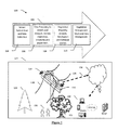
- the workflow diagram, 102 illustrates the main steps, 104 , 106 , 108 and 110 in the system.
- the sensor package continuously, periodically, intermittently or based on an event scans in step, 104 for electric wires, transmission towers, power poles, terrain, vegetation and structures along the span of the electric lines.
- Single or multiple sensors with fixed or adjustable zoom and field of view (FOV) are installed on each power pole or tower.
- the sensor package and installation provide 100% scan coverage of the electric utility ROW.
- the sensor package images and data are processed in step, 106 in situ or sent to the cloud computing platform for processing.
- Image data is classified to delineate and measure 3D objects such as electric power structure, lines, vegetation and ground.
- 3D objects such as electric power structure, lines, vegetation and ground.
- shapes in the point clouds can be aligned at each observation instant with image registration.
- the vegetation proximity analysis, 108 compares the 3D vegetation and distance-to-wire measurements to the required MVCD and issues applicable notifications (VPA or VRA) to the end users for each vegetation and in a span.
- VPA or VRA applicable notifications
- the sensor package includes visual or tactical type of sensors.
- the sensor packages capture images/range data and meta data to measure the location and dimensions of power lines, 118 and vegetation, 120 and 122 and determine proximity to power lines, 118 .
- the sensor package images and data are processed onboard the senor package, 114 or sent to the cloud, 124 over wireless or wired network, 126 .
- the vegetation proximity results are sent to the end users, 128 over the internet to their desktop or mobile devices, 130 . Vegetation management teams and tree trimming crews, 128 use the vegetation proximity measurements information and advisories on their devices, 130 to schedule, perform and manage vegetation maintenance work as required.
- the end users, 128 with devices, 130 select the area of interest or highest priority vegetation proximity notifications, and downloads the GIS maps with vegetation data to the local drive of the portable device to be available if the device, 130 is used outside of wireless networks.
- Vegetation crews perform tree work and record the results on the portable device and sync the results data back to the system after completion.
- This data sync process updates the VPA and VRA for the entire system to allow resources to be directed to the next highest priority area for vegetation management work to be scheduled by location and travel logistics in concert.
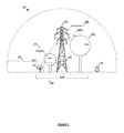
- FIG. 2 there is shown generally an electric power line and transmission tower environment, 200 in which embodiments of the present invention operates.
- the sensor package, 202 attached to the power pole or tower or structure, 204 to automatically observes and collect image, spatial and weather data including, visual digital images, video, infrared (IR), LiDAR, RADAR, Sonar, range finder, multi-spectral, hyper-spectral, range, global positioning system (GPS) longitude, latitude, wind speed, ambient temperature, altitude, date and time which are associated with the data.
- IR infrared
- LiDAR LiDAR
- RADAR LiDAR
- Sonar Sonar
- range finder multi-spectral
- hyper-spectral range
- range global positioning system
- Collected imageries of electric wires, 206 , vegetation, 208 , 210 , 212 and surrounding power poles, towers or structures, 214 and terrain, 216 are processed automatically to produce the required information including, classified images, measurements of power lines, power poles or transmission towers, terrain, vegetation, proximity analysis, 2D map, 3D map, VPA and VRA using proprietary methods and algorithms of the present invention.
- the common vegetation, 208 , 210 and 212 may include ash, black oak, blue, casuarinas, cottonwood, cypress, deodar, Douglas fir, eucalyptus, gray pine, incense cedar, live oak, oak, palm, ponderosa pine, as well as other pine and deciduous species and brushes/bushes which can pose encroachment related risks to the transmission and distribution lines.
- the wires, 206 types generally include, Aluminum Conductor Steel Reinforced (ACSR), All Aluminum Alloy Conductor (AAAC), Aluminum Conductor Self Supporting (ACSS) or copper conductors.
- the sensor package, 202 uses a digital camera or infrared or multi-spectral or hyper-spectral sensors. Multiple georeferenced aerial images of a ROW are acquired with specific overlap to be used with photogrammetric tools and techniques to produce colorized high density point cloud and surface mesh. The range or depth of an observed object is interpolated based on the lens disparity of this stereoscopic camera system.
- the sensor package, 202 uses a LiDAR sensor and optional digital camera to acquire georeferenced raw LiDAR data and optional photograph to produce colorized point could. The range or depth of an observed object is directly calculated based on the velocity of light in this method.
- the sensor package, 202 includes a digital camera and range finder.
- This sensor package interprets pictures and tactical range data to produce VPA and VRA using proprietary machine vision and learning algorithms.
- the sensor package, 202 uses a range finder which scans the horizontal plane of the maximum allowed tree height of a span. When a tree grows up to the plane of maximum allowable tree height then the VPA or VRA notification is issued for that span automatically.
- This simplified tactical sensor-based system reduces the computational burden, data storage size and cost of the sensor package.
- These embodiments can be used in various combinations and in any of these embodiments the data is stored in local storage and/or upload to the cloud system for onsite or remote processing.
- the data transmission includes LAN/PAN/WAN/Wi-Fi/Cell/802.1/FTP protocols.
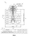
- the sensor package, 202 includes general features and functions such as rechargeable battery system, 218 with battery management sub systems to ensure long battery life, the sensor lens, 220 , one or more of active and passive visual or tactical sensors such as digital camera in the visible spectrum to acquire pictures and video, infrared (IR) camera, range finder, multi-spectral sensor, hyper-spectral sensor, LiDAR sensor, RADAR, Sonar, embedded microprocessor image processing engine, 222 , data storage such as hard drive, removable media storage, 224 , wireless antenna such as Wi-Fi, Bluetooth, cellular phone, 226 , wired data connection such as USB, Ethernet, RS232 serial communications, Modbus, CAN bus, analog or digital inputs or outputs and solar panel, 230 to charge the battery system and waterproof rugged enclosure, 232 for year round outdoor use.
- active and passive visual or tactical sensors such as digital camera in the visible spectrum to acquire pictures and video, infrared (IR) camera, range finder, multi-spectral sensor, hyper-spectral sensor, LiDAR sensor,
- FIG. 3 there is shown generally a flow chart, 300 of automated vegetation proximity data collection and processing in which embodiments of the present invention operates.
- One or more sensor packages are installed on one or more power pole(s)/tower(s) or structure(s) per span, 302 .
- 304 automatically collect location and shape of objects within a power line span.
- the sensor packages, 306 has an adjustable FOV.
- a wide angle (greater than 90 degrees) FOV enables image collection of nearby vegetation and the base of the power pole or tower to which the sensor package is attached.
- a medium or narrow field of view enables high resolution imaging of vegetation, power lines, terrain and structures at a distance greater than the distance to the next power pole or tower, thus creating a system with 100% coverage of all the power lines, structures, terrain and vegetation within a span. This arrangement is replicated for each span to cover the entire power line system.
- results of the analysis, 308 are the data and maps generated by this present invention which is distributed among the users using one of the embodiments.
- the current and historical results are transmitted over a wired or wireless network to the client server system.
- the raw sensor data and images are transmitted by a wired or wireless network to the server system which performs the image processing and production of analysis products which are sent to the end users.
- the sensor package with adjustable FOV, 400 scans and collects images of multiple fields of view for each collection scan to maintain good resolution and complete coverage.
- the sensor FOV is remotely adjustable and programmable to automatically collect multiple scans of multiple FOVs for each line span.
- the FOV is greater than 90 degrees allowing for a fish eye effect to collect a wide footprint and provide coverage of nearby vegetation and the electric lines and structure to which the sensor package is attached.
- the medium FOV, 406 the sensor range is increased while the footprint and coverage will overlap with the wide FOV to ensure complete coverage.
- the narrow FOV setting, 408 the range is increased and the coverage will overlap with the medium FOV to ensure complete coverage.
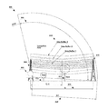
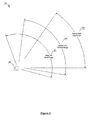
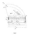
- FIG. 5 there is shown the end view of an electric transmission line ROW, 500 .
- the sensor package, 502 is installed on transmission tower, 504 .
- Power lines, 506 and trees 508 , 510 , 512 and 514 are within the sensor package FOV, 516 .
- All the vegetation/trees, 508 , 510 , 512 within the electric ROW, 518 and vegetation and trees, 514 outside the ROW, 518 are within the sensor FOV, 516 .
- This arrangement allows for the proposed invention to accurately identify and measure all vegetation encroachment threats including those that may grow up in to the power lines, 508 and those which may fall in to the power lines, 510 .
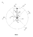
- FIG. 6 an example of the vertical and horizontal zones and buffers around a set of power lines are shown with trees to describe the vegetation detection criteria, 600 .
- the transmission tower, 602 has multiple power lines of a circuit. Each line is assigned multiple rings of buffers, 604 based on the line voltage and required MVCD.
- the MVCD for each line is defined by the regulatory agencies and adopted by the utilities.
- An example schema of MVCD for different line voltages is shown in table, 606 .
- the horizontal zones, 608 and the vertical zones, 610 are defined for grow-in and fall-in tree detection based on the MVCD. These zones are adjusted for the terrain within each span to account for flat and sloped terrains.
- the tree, 612 occupies a set of multiple zones and the tree, 614 occupies a different set of multiple zones. Both of these trees, 612 and 614 is assigned unique identification numbers, GPS coordinates in latitude and longitude and optometric height above ground, 616 , canopy radius and type/species.
- the tree, 614 height is reaching the MVCD threshold. Therefore, the system will automatically issue a VRA for the tree crews to accomplish tree clearance action.
- the tree, 612 height is less than the MVCD. Therefore, the system will automatically issue a VPA to the vegetation management personnel for information only.
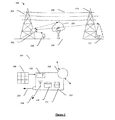
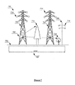
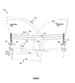
- FIG. 7 an embodiment of the current invention wherein an end view of a single electric utility corridor/ROW, 700 with multiple transmission towers, 702 and 704 and an under build distribution pole, 706 are shown.
- the sensor package, 708 is installed on tower, 702 to be able to image all electric wires, 710 , 712 and 714 , the vegetation, 716 and 718 and structures, 704 and 706 within the ROW, 720 and is able to detect and measure vegetation distances between the transmission and distribution lines.
- a single sensor package per span with full span coverage 800 is shown.
- a single sensor package, 802 is installed on a transmission tower, 804 with a FOV, 806 and range, 808 equals to D1 which scans the complete distance to the next tower, 810 equals to D of the span.
- This single sensor package with fixed or adjustable FOV is able to scan the ground, vegetation, electric lines and towers.
- the sensor package scans and detects vegetation, 812 and 814 within the sensor FOV, 806 .
- the vegetation is ranked by its proximity to the power lines and 3D cylindrical buffers, 816 around each wire based on the wire voltage.
- a single sensor package covers the entire span distance to then next tower and additional range to overlap scan coverage by the sensor package on the subsequent tower.
- a single sensor package per tower provides 100% coverage of the electric wires, towers, terrain and vegetation in a span.
- FIG. 9 an embodiment of the current invention wherein a dual sensor package per span with full span coverage, 900 is shown.
- a dual sensor package, 902 and 904 has the range, 906 equals to D1 which is slightly greater than the mid span distance, 908 equals to D/2 are installed on tower, 910 and 912 , respectively.
- Each sensor package has overlapping FOV, 914 and 916 to provide 100% coverage of the electric lines, 918 , structures, terrain and vegetation, 920 and 922 in the span, 924 equals to D.
- This design requires two sensor packages per tower to be installed to cover subsequent spans.
- FIG. 10 an embodiment of the current invention wherein a bird's eye view of a single sensor with adjustable FOV per span with full span coverage, 1000 is shown.
- a sensor package, 1002 is installed on tower, 1004 which can use an adjustable FOV to scan the entire footprint of the span ROW, 1006 .
- the sensor package with adjustable FOV can be combined with the previously described embodiments with single or multiple sensor packages per span.
- the sensor package scans the span, the sensor automatically collects data and scans the area for each FOV setting.
- the FOV settings provide overlap to ensure 100% coverage of the ROW in the span to scan the nearby vegetation, 1008 , medium distant vegetation, 1010 and distant vegetation, 1012 within the ROW of the span.
- the senor automatically collects imagery data with a wide FOV, 1014 which captures the nearby ground and vegetation, 1008 and power lines 1016 , a medium FOV, 1018 which scans the power lines, 1016 , and intermediate distant vegetation, 1010 and a narrow FOV, 1020 which scans the power lines, 1016 and terrain and vegetation past the next tower, 1022 .
- This variable FOV sensors allow for high resolution and accuracy for both nearby and distant scans within a span.
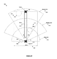
- FIG. 11 in this embodiment wherein 4 sensor packages per tower are used to provide 100% coverage of the ROW and beyond for a span is shown in the bird's eye view, 1100 .
- the transmission tower or power pole, 1102 has 4 sensors, 1104 , 1106 , 1108 and 1110 installed such that each sensor's FOV covers a portion of the ROW and beyond.
- Sensor, 1104 scans the area parallel with the span and scans power lines, 1112 and vegetation, 1114 within sensor FOV, 1116 .
- Sensor, 1106 scans the area to the right side of the transmission tower, 1102 within FOV, 1118 .
- the sensor, 1106 FOV, 1118 may be adjacent or overlapping with sensor, 1104 and sensor, 1108 FOVs.
- the sensor, 1108 FOV, 1120 scans in parallel with the span facing the opposite direction as sensor, 1104 .
- Sensor, 1110 FOV, 1122 completes the coverage with adjacent or overlapping coverage with sensors, 1104 and 1108 .
- a tree, 1124 which is in close proximity to the transmission tower, 1102 is not in the FOV of sensor, 1104 but is captured by the scan of the sensor, 1110 with a FOV, 1122 to the left side of the transmission tower, 1102 .
- This embodiment may be combined with other previously described embodiments to optimize the system of sensor packages for a given electric ROW, 1126 and spans to provide 100% coverage for vegetation encroachment detection requirements with no blind spots.
- the sensor package layer, 1202 is the data and image collection process which feeds data to the data layer, 1204 .
- the application layer, 1206 using a combination of proprietary artificial intelligence algorithms, scripts, and off-the-shelf software and central processing unit (CPU), graphics processing unit (GPU) and tensor processing unit (TPU) hardware, processes the data and images, calculates location and dimensions of vegetation, power lines and structures and calculate the vegetation proximity to electric lines based on pre-defined MVCD thresholds.
- the data product of this application layer is the proximity and resolution for each vegetation. This results are sent to the data layer, 1204 .
- the VPA and VRA results with location, dimension and meta data are stored in the database. Each time a new observation/scan is completed for a span, the most recent results are stored and the previous results are stored for a period of time to allow for the changes to be tracked for the period of time intervals.
- the geographic information system (GIS) engine and data file conversion engine, 1208 extracts data on request from the users through the user interface layer, 1210 . These users may use the extracted data while having access to the internet or may choose to download the data to a mobile device for use in the field through server layer, 1212 . Users select areas of power lines, spans, or towers by ID or name or by drawing a polygon on an interactive map using the client server, 1214 .
Landscapes
- Business, Economics & Management (AREA)
- Human Resources & Organizations (AREA)
- Engineering & Computer Science (AREA)
- Strategic Management (AREA)
- Entrepreneurship & Innovation (AREA)
- Economics (AREA)
- Physics & Mathematics (AREA)
- Marketing (AREA)
- Operations Research (AREA)
- Quality & Reliability (AREA)
- Tourism & Hospitality (AREA)
- General Business, Economics & Management (AREA)
- General Physics & Mathematics (AREA)
- Theoretical Computer Science (AREA)
- Game Theory and Decision Science (AREA)
- Development Economics (AREA)
- Educational Administration (AREA)
- Computer Networks & Wireless Communication (AREA)
- Management, Administration, Business Operations System, And Electronic Commerce (AREA)
Abstract
Description
- The present application claims priority to the U.S. Provisional Patent Application Ser. No. 62/348,950, entitled, “Method and system for utility power lines vegetation proximity monitoring and controlling,” filed Jun. 12, 2016, incorporated by reference herein in its entirety.
- Electric utility overhead transmission (bulk and local systems) and distribution power lines/wires/conductors are carried on metallic and nonmetallic towers and poles across very long distances in many directions which include metropolitan, urban, suburban and rural areas. Vegetation/trees from the surroundings can potentially encroach in to the overhead high voltage (4 kilo volt [kV] and above) electric lines, eventually contacting or striking these lines. These vegetation encroachment events may bring the energized lines down to the ground, ignite surrounding vegetation and cause unscheduled electric service disruptions (blackouts). These hazards are amplified in drought seasons when dead trees in the proximity of the utility power lines could fall over these high voltage electric conductors and start wildfire. The utilities and/or power lines maintenance companies need to cyclically inspect these power lines to monitor and assess vegetation conditions and mitigate hazards from potential vegetation encroachments. Based on the vegetation condition inspection findings, the power line vegetation maintenance crews cut/trim or remove vegetation/trees that reach a threshold proximity to the power lines as predefined by the relevant regulatory agencies and utility companies. There are federal, state, regional, and local level regulatory agencies to oversea this vegetation management compliance process in the United Sates. A few examples of such regulatory agencies and their applicable vegetation management regulations in the United States are, North American Electric Reliability Corporation (NERC) FAC-003-04, California Public Utilities Commission (CPUC) General Order (GO) 95 and California Fire Department (CAL Fire) Public Resource Code (PRC) 4292 and 4293 etc. The regulatory agencies and the utility companies within their jurisdictions have developed required minimum vegetation clearance distance (MVCD) parameter for these lines based on the rated line voltages, minimum ground to conductor clearance (MGCC) requirements, geographic locations and their compliance inspection cycles. The maximum allowable vegetation height (MAVH) under or around high voltage power lines right-of-way (ROW) is mainly controlled by the MGCC and required MVCD parameters. The utility vegetation management line of business must ensure compliance to this MVCD requirements for the electric lines that they own or maintain. The This electric transmission and distribution vegetation management is a mandatory compliance process that electric utility companies (investors owned, publicly owned or privately owned), Transmission Owners (TO) and Generation Owners (GO) must carry out to ensure safe, reliable and affordable electricity supply to their customers and prevent any hazards to the environment from potential vegetation related flash-over hazards and resulting blackouts. Noncompliance to these regulations may impose steep fines and other punishments to the responsible utility companies, TO or GO.
- The state-of-the-art power lines routine and non-routine patrolling process for vegetation management is a manual, tedious and costly process which involves rigorous boots-on-the-ground or foot patrolling by large inspection crews round the year. Routine patrol is cyclical and non-routine process is scheduled as need to cover requirements of special programs such as integrated vegetation management, tower or pole vegetation clearance management, emergency condition such as drought related vegetation management etc. Many crews patrol these electric lines by driving their motor vehicles and/or walking where no accessible road is available in and out of an electric lines right-of-way (ROW) under these routine and non-routine utility vegetation management programs. According to the applicable regulations, certain electric utility companies have to inspect hundred percent of their electric lines they own even though some portions of the total line length or spans (span is comprised of two subsequent towers or poles of a contiguous electric transmission or distribution line) may not have any vegetation in their proximities (wire zone and non-wire zone) that can possess any hazards by encroaching to a line (grow in to or fall in to). This foot patrol process imposes extra hazards to the inspectors in heavily wooded rugged terrains. This is a wasteful and risky process that being practiced by the electric utility industry for decades. A safer, more efficient and automated method of vegetation condition inspection is required for the electric utilities power lines vegetation management. Electric lines are counted in the unit of line miles. An electric utility company may own from a few to thousands of line miles of overhead electric transmission and/or distribution lines depending on its service territory and number of customers it serves. In certain geographic service areas in the United States an electric utility company may be responsible to manage several millions of trees along their overhead transmission and distribution electric lines right-of-way (ROW). In this situation total number of trees may be translated into a unit based quantity such as number of trees per line mile. No vegetation to a few thousand trees per line mile are not unusual for a large electric utility company in the United States.
- In another state-of-the-art approach, aerial patrol of the electric lines for vegetation condition and encroachment detections is conducted by a pilot and an inspector from an aircraft flying over the electric transmission lines. This is a visual inspection method that requires flying two personnel over the electric lines in certain intervals to complete the cyclical inspections. A rotorcraft (helicopter) needs to fly at a lower altitude (about 400 feet to 500 feet above ground level [AGL]) in order to assess the vegetation condition and encroachment visually from the rotorcraft by the vegetation management inspection crew. This method is costly, creates loud engine noise in the neighborhood and faces objections from the utility customers in habitable areas. In addition, flying such close distance to the high voltage transmission lines is hazardous to the people and property.
- In another recent approach, airborne sensor-based patrol method using light detection and ranging (LiDAR) technology is used by a few utility companies for their vegetation management compliance inspection process. While this approach introduces certain degrees of remote sensing and process automation, this is inefficient for this particular application because it involves frequent aircraft flights over the power lines that run in many different directions in relatively shorter segments. This directional variation and segmentation of the power lines forces the LiDAR scan and data collection aircraft to unnecessarily fly over the areas that do not have any power lines because of practical maneuverability of the sensor carrying aircraft. In addition, airborne LiDAR survey do not produce real time information about the vegetation proximity around the power lines. Therefore, this monitoring process must be accomplished frequently every year. This is a costly effort. A large portion of the transmission line length of an electric utility company may not have vegetation along the ROW. In aerial LiDAR-based inspection method, the sensors have to fly over those vegetation free line lengths each year to comply with the cyclical inspection requirements in absence of a real-time power line vegetation monitoring system and method. The vegetation proximities to a power line at the time of LiDAR sensor flight do not capture the minimum possible proximities due to the higher conductor sag at the maximum operating load condition (amperage) and blow-out due to higher wind gust than the flying condition. Extensive modeling of the power line sage due to the load variations (to the maximum operating load condition), ambient temperatures and wind speed and direction variations are required to predict vegetation proximity situations at maximum load condition for each power line which must be compared with the line specific MVCD to determine required vegetation controlling measures. This method is a tedious process because it involves extensive manual data processing and modeling after each airborne LiDAR scan cycle. The time lapse between the successive scans and data processing is excessive which fails to accurately capture the actual growth of a tree within this time lapse. As a result, a required MVCD compliant tree from a scan cycle may grow taller enough to exceed the MVCD and become noncompliant during the time lapse between the successive scan. This kind of vegetation clearance noncompliance risk is higher in certain geographic and environmental regions such as riparian or orchard zones where tree growth rate along ROW is very high (e.g. about 20 feet/year). Airborne LiDAR survey cannot flag these special climatic regions without extensive manual post processing of native survey data. Therefore, the airborne LiDAR-based vegetation management process for the utility power lines involving a very large number of LiDAR scanning flights each year and extensive data processing is a huge waste of time and financial resources and threat to the environment.
- Despite the aforementioned state-of-the-art approaches to manage vegetation, most of the electric utilities frequently report vegetation related power outages. The severity of damages from the electric transmission line power outages due to the vegetation encroachment is relatively higher than distribution line power outages. Vegetation encroachment related damage of a transmission line can cause cascading power outage across the power grid of a very large geographic area or even of the entire nation causing billions of dollars of economic damages. Therefore, an alternative approach is necessary for this highly critical compliance application of the utility power lines vegetation management which is more accurate, reliable, efficient, safer and cost effective.
- Thus, there remains a heartfelt need for an improved system and method in which the utility power lines vegetation management process can protect the nation's critical power infrastructures, human lives, properties and environment with higher reliability, accuracy and efficiency.
- This current invention uses stationary visual and/or tactical sensor-based remote sensing, computing technologies and proprietary machine vision and machine learning algorithms over wireless and/or internet communication network system to automatically detect and measure vegetation proximity to the high voltage power lines and advise maintenance crews to trim/cut or remove vegetations/trees that reach a predefined threshold proximity to the high voltage utility power lines. This current sensor-based vegetation monitoring and controlling invention is a more efficient and cost effective alternative to the state-of-the-art utility power lines vegetation compliance management processes. This invention issues vegetation proximity advisory (VPA) and vegetation resolution advisory (VRA) to the electric utility vegetation management crews based on the proprietary machine learning and artificial intelligence algorithms without needing any human field power line vegetation inspectors. The power lines infrastructures such as towers, poles and conductors are in geospatially static environment which is favorable for monitoring these infrastructures remotely using this current invention. The stationary sensors may be capable of optical imaging, electromagnetic sensing or sonic sensing across wide range of spectrum including but not limiting to, red green blue (RGB) visual band, infrared (IR), multispectral (MS), Hyper-spectral (HS), light detection and ranging (LiDAR), radio detection and ranging (RADAR), synthetic aperture radar (SAR) or ultrasonic. These sensors consume low power which may be provided using integrated batteries and/or solar power source. Single or multiple sensors of different types can be used per power lines tower or pole to monitor vegetation encroachments. The sensors can be programmed for continuous and/or intermittent monitoring of the surroundings at certain spatial and temporal intervals. Based on the sensor observation over discrete time steps around a power line surrounding location the system estimates vegetation relative location and construct map of the environment using the connected and/or cloud computing system. The map output is geometrically accurate as well as topological representation of the relative distances among the objects of interest. The computation method considers slow growing movement of vegetation and relatively faster movement of conductors due to occasional high wind blow-out and applies effective digital filters to reduce any bias and measurement noise. The computation results provide vegetation proximity advisories to the end users via connected devices such as personal computers, laptop computers, tablets and mobile/cellular phones. Whenever a vegetation proximity reaches a predefined critical or potential hazard threshold distance to a power line, the system will issue the appropriate VPA and VRA for that particular location based on spatial situation of the georeferenced sensor. The end users (vegetation management or control crews) can take necessary actions based on the automatic advisory issued by this invention. This method and system requires one time installation of the sensor packages to the power lines poles/towers which can last for many years without frequent maintenance and/or replacement. The year round cyclic inspections of the power lines by foot patrolling, air patrolling or LiDAR sensor equipped aircraft flying are eliminated by this current invention. Hence, this current invention is a safer, more efficient and cost effective system and method of electric utility power lines vegetation management.
- In one embodiment, this invention uses a stationary remote sensing sensor package that is attached/mounted on an electric transmission tower/pole to monitor surrounding vegetation encroachment within the critical zones along a ROW. Each sensor package is geospatially oriented as survey control points in standard spatial coordinate reference system using horizontal and vertical datum. The geo-referencing system adds important additional geographic information such as riparian climatic region, national forest region, orchard region of the sensor package location when applicable. This sensor's viewing range and field of view (FOV) will cover an entire line span to the next tower after this host tower within the same span. Similarly, the subsequent line spans will be monitor by the sensors mounted on the subsequent towers. This method involves producing classified point clouds in three dimension (3D) and or image classification in spatial coordinates from geographically oriented and georeferenced images acquired from the tower mounted sensors and applying novel algorithms for extracting features and calculating location, height and 3D distance of vegetation segments from the subject electric transmission lines. The system provides VPA or VRA to the designated utility vegetation management personnel depicting the proximity of trees to the subject lines and suggested actions through the wired or wireless communication network in predefined temporal resolutions. The vegetation management personnel take necessary mitigation actions according the VPA or VRA received from a georeferenced sensor. The fidelity of a VPA or VRA will mostly depend on the sensor resolution and accuracy.
- In another embodiment, this invention uses multiple stationary remote sensing sensor packages that are mounted on each electric transmission tower/pole to monitor surrounding vegetation encroachment within the critical zones along a ROW from multiple directions. This sensor's viewing range and field of view (FOV) will cover an entire line span to the next tower after this host tower. Similarly the subsequent line spans will be monitor by the sensors mounted on the subsequent towers. This method involves producing classified point clouds in three dimensional (3D) and or image classification in spatial coordinates from geographically oriented and georeferenced images acquired from the tower/pole mounted sensors and applying novel algorithms for extracting features and calculating location, height and 3D distance of vegetation segments from the subject electric transmission lines. The system provides VPA and VRA. to the designated utility vegetation management personnel depicting the proximity of vegetation to the subject lines through the wired or wireless communication network in predefined temporal resolutions. The vegetation management personnel take necessary mitigation actions according the VPA or VRA received from the georeferenced sensors.
- In another embodiment of this invention, the stationary sensor packages remotely monitor and report vegetation growth within predefined zones around the utility power line towers and poles. This reporting is used to maintain vegetation clearance around the towers and poles.
- In another embodiment, this invention enables utility vegetation management personnel to remotely assess health condition of vegetation in a ROW.
- Many other features and advantages of the present invention will be realized by those skilled in the art upon reading the following description, when considered in conjunction with the drawings, in which:
-
FIG. 1 illustrates a graphical overview of the system and method organized to implement embodiments of the present invention. -
FIG. 2 illustrates a set of exemplary functional data acquisition and processing and communication equipment in a typical utility power line span to implement one of the embodiments of the present invention. -
FIG. 3 illustrates a diagrammatic presentation of the sequential steps performed in the automated image data processing in accordance with the present invention. -
FIG. 4 illustrates imaging sensor field of view range and sensing efficacy to implement one of the embodiments of the present invention. -
FIG. 5 illustrates exemplary images of vegetation proximity detection categories along utility power lines in accordance with the present invention. -
FIG. 6 illustrates vegetation proximity detection criteria and schema along the power lines in accordance with the present invention. -
FIG. 7 illustrates a situation where multiple transmission circuits and distribution circuits share a single corridor and vegetation proximity detection criteria and determination schema along the multi-circuit power lines in accordance with the present invention. -
FIG. 8 illustrates a side view of the single sensor package per span-based detection range and field of view in accordance with the present invention. -
FIG. 9 illustrates a side view of the two sensor packages per span-based detection range and field of view in accordance with the present invention. -
FIG. 10 illustrates a top view of the one sensor package per span-based detection range and field of views in accordance with the present invention. -
FIG. 11 illustrates a top view of the multiple sensor packages per tower in span-based detection range and field of views in accordance with the present invention. -
FIG. 12 illustrates a diagrammatic representation of the remote sensing and computing environment and user interface to implement one of the embodiments of the present invention. - Directing attention to
FIG. 1 , there is shown the steps and functional components of the embodiments of the present invention, 100. The workflow diagram, 102 illustrates the main steps, 104, 106, 108 and 110 in the system. The sensor package continuously, periodically, intermittently or based on an event scans in step, 104 for electric wires, transmission towers, power poles, terrain, vegetation and structures along the span of the electric lines. Single or multiple sensors with fixed or adjustable zoom and field of view (FOV) are installed on each power pole or tower. The sensor package and installation provide 100% scan coverage of the electric utility ROW. The sensor package images and data are processed in step, 106 in situ or sent to the cloud computing platform for processing. Image data is classified to delineate and measure 3D objects such as electric power structure, lines, vegetation and ground. In case of a visual sensor, shapes in the point clouds can be aligned at each observation instant with image registration. Following this processing step, the vegetation proximity analysis, 108 compares the 3D vegetation and distance-to-wire measurements to the required MVCD and issues applicable notifications (VPA or VRA) to the end users for each vegetation and in a span. Finally in step, 110 vegetation management crews perform work and record the results on the portable device and sync the work completion record back to the vegetation management system database. - The graphical representation of the system in, 112 where one or more sensor package(s), 114 are attached to a power pole/tower or structure, 116. The sensor package includes visual or tactical type of sensors. The sensor packages capture images/range data and meta data to measure the location and dimensions of power lines, 118 and vegetation, 120 and 122 and determine proximity to power lines, 118. The sensor package images and data are processed onboard the senor package, 114 or sent to the cloud, 124 over wireless or wired network, 126. The vegetation proximity results are sent to the end users, 128 over the internet to their desktop or mobile devices, 130. Vegetation management teams and tree trimming crews, 128 use the vegetation proximity measurements information and advisories on their devices, 130 to schedule, perform and manage vegetation maintenance work as required.
- In one embodiment of the present invention where the end users, 128 with devices, 130 select the area of interest or highest priority vegetation proximity notifications, and downloads the GIS maps with vegetation data to the local drive of the portable device to be available if the device, 130 is used outside of wireless networks. Vegetation crews perform tree work and record the results on the portable device and sync the results data back to the system after completion. This data sync process updates the VPA and VRA for the entire system to allow resources to be directed to the next highest priority area for vegetation management work to be scheduled by location and travel logistics in concert.
- Directing attention to
FIG. 2 , there is shown generally an electric power line and transmission tower environment, 200 in which embodiments of the present invention operates. The sensor package, 202 attached to the power pole or tower or structure, 204 to automatically observes and collect image, spatial and weather data including, visual digital images, video, infrared (IR), LiDAR, RADAR, Sonar, range finder, multi-spectral, hyper-spectral, range, global positioning system (GPS) longitude, latitude, wind speed, ambient temperature, altitude, date and time which are associated with the data. Collected imageries of electric wires, 206, vegetation, 208, 210, 212 and surrounding power poles, towers or structures, 214 and terrain, 216 are processed automatically to produce the required information including, classified images, measurements of power lines, power poles or transmission towers, terrain, vegetation, proximity analysis, 2D map, 3D map, VPA and VRA using proprietary methods and algorithms of the present invention. The common vegetation, 208, 210 and 212 may include ash, black oak, blue, casuarinas, cottonwood, cypress, deodar, Douglas fir, eucalyptus, gray pine, incense cedar, live oak, oak, palm, ponderosa pine, as well as other pine and deciduous species and brushes/bushes which can pose encroachment related risks to the transmission and distribution lines. The wires, 206 types generally include, Aluminum Conductor Steel Reinforced (ACSR), All Aluminum Alloy Conductor (AAAC), Aluminum Conductor Self Supporting (ACSS) or copper conductors. - In one embodiment, the sensor package, 202 uses a digital camera or infrared or multi-spectral or hyper-spectral sensors. Multiple georeferenced aerial images of a ROW are acquired with specific overlap to be used with photogrammetric tools and techniques to produce colorized high density point cloud and surface mesh. The range or depth of an observed object is interpolated based on the lens disparity of this stereoscopic camera system. In another embodiment, the sensor package, 202 uses a LiDAR sensor and optional digital camera to acquire georeferenced raw LiDAR data and optional photograph to produce colorized point could. The range or depth of an observed object is directly calculated based on the velocity of light in this method. In another embodiment, the sensor package, 202 includes a digital camera and range finder. This sensor package interprets pictures and tactical range data to produce VPA and VRA using proprietary machine vision and learning algorithms. In another embodiment the sensor package, 202 uses a range finder which scans the horizontal plane of the maximum allowed tree height of a span. When a tree grows up to the plane of maximum allowable tree height then the VPA or VRA notification is issued for that span automatically. This simplified tactical sensor-based system reduces the computational burden, data storage size and cost of the sensor package. These embodiments can be used in various combinations and in any of these embodiments the data is stored in local storage and/or upload to the cloud system for onsite or remote processing. The data transmission includes LAN/PAN/WAN/Wi-Fi/Cell/802.1/FTP protocols. The sensor package, 202 includes general features and functions such as rechargeable battery system, 218 with battery management sub systems to ensure long battery life, the sensor lens, 220, one or more of active and passive visual or tactical sensors such as digital camera in the visible spectrum to acquire pictures and video, infrared (IR) camera, range finder, multi-spectral sensor, hyper-spectral sensor, LiDAR sensor, RADAR, Sonar, embedded microprocessor image processing engine, 222, data storage such as hard drive, removable media storage, 224, wireless antenna such as Wi-Fi, Bluetooth, cellular phone, 226, wired data connection such as USB, Ethernet, RS232 serial communications, Modbus, CAN bus, analog or digital inputs or outputs and solar panel, 230 to charge the battery system and waterproof rugged enclosure, 232 for year round outdoor use.
- Directing attention to
FIG. 3 , there is shown generally a flow chart, 300 of automated vegetation proximity data collection and processing in which embodiments of the present invention operates. One or more sensor packages are installed on one or more power pole(s)/tower(s) or structure(s) per span, 302. In the data collection and data analysis process, 304 automatically collect location and shape of objects within a power line span. - In one embodiment the sensor packages, 306 has an adjustable FOV. A wide angle (greater than 90 degrees) FOV enables image collection of nearby vegetation and the base of the power pole or tower to which the sensor package is attached. A medium or narrow field of view enables high resolution imaging of vegetation, power lines, terrain and structures at a distance greater than the distance to the next power pole or tower, thus creating a system with 100% coverage of all the power lines, structures, terrain and vegetation within a span. This arrangement is replicated for each span to cover the entire power line system.
- In the flow chart step, 308 proprietary algorithms and off-the-shelf image and data processing tools are used to classify and measure power lines, vegetation, terrains and structures. After each measurement the objects are counted and compared to pre-defined zones and buffers as dictated by the applicable MVCD. The wind speed and resulting power lines wind sway (blow-out), line load and ambient temperature and resulting power line sag are automatically captured in this real-time scan and computations without any intensive manual modeling. The scan frequency and time step can be adjusted to as often as needed or based on significant weather events such as before or after a storm, events of high wind speed, rain and lightning. VPA and VRA are automatically generated for each span following any observations/scans.
- In vegetation proximity data transfer and management process, 310 results of the analysis, 308 are the data and maps generated by this present invention which is distributed among the users using one of the embodiments. The current and historical results are transmitted over a wired or wireless network to the client server system. In another embodiment of 310 the raw sensor data and images are transmitted by a wired or wireless network to the server system which performs the image processing and production of analysis products which are sent to the end users. These embodiments allow for installation and operation of this system in areas with high bandwidth wireless networks, in areas with lower bandwidth wireless networks or without any preexisting wireless networks by creating a new wireless network with each sensor package as needed.
- Directing attention to
FIG. 4 , there is shown generally the sensor package with adjustable FOV, 400. The sensor package, 402 scans and collects images of multiple fields of view for each collection scan to maintain good resolution and complete coverage. The sensor FOV is remotely adjustable and programmable to automatically collect multiple scans of multiple FOVs for each line span. When the wide FOV, 404 is used, the FOV is greater than 90 degrees allowing for a fish eye effect to collect a wide footprint and provide coverage of nearby vegetation and the electric lines and structure to which the sensor package is attached. When the medium FOV, 406 is used, the sensor range is increased while the footprint and coverage will overlap with the wide FOV to ensure complete coverage. When the narrow FOV setting, 408 is used, the range is increased and the coverage will overlap with the medium FOV to ensure complete coverage. - Directing attention to
FIG. 5 , there is shown the end view of an electric transmission line ROW, 500. The sensor package, 502 is installed on transmission tower, 504. Power lines, 506 andtrees - Directing attention to
FIG. 6 , an example of the vertical and horizontal zones and buffers around a set of power lines are shown with trees to describe the vegetation detection criteria, 600. The transmission tower, 602 has multiple power lines of a circuit. Each line is assigned multiple rings of buffers, 604 based on the line voltage and required MVCD. The MVCD for each line is defined by the regulatory agencies and adopted by the utilities. An example schema of MVCD for different line voltages is shown in table, 606. The horizontal zones, 608 and the vertical zones, 610 are defined for grow-in and fall-in tree detection based on the MVCD. These zones are adjusted for the terrain within each span to account for flat and sloped terrains. The tree, 612 occupies a set of multiple zones and the tree, 614 occupies a different set of multiple zones. Both of these trees, 612 and 614 is assigned unique identification numbers, GPS coordinates in latitude and longitude and optometric height above ground, 616, canopy radius and type/species. In this example, 600, the tree, 614 height is reaching the MVCD threshold. Therefore, the system will automatically issue a VRA for the tree crews to accomplish tree clearance action. The tree, 612 height is less than the MVCD. Therefore, the system will automatically issue a VPA to the vegetation management personnel for information only. - Directing attention to
FIG. 7 , an embodiment of the current invention wherein an end view of a single electric utility corridor/ROW, 700 with multiple transmission towers, 702 and 704 and an under build distribution pole, 706 are shown. Here the sensor package, 708 is installed on tower, 702 to be able to image all electric wires, 710, 712 and 714, the vegetation, 716 and 718 and structures, 704 and 706 within the ROW, 720 and is able to detect and measure vegetation distances between the transmission and distribution lines. - Directing attention to
FIG. 8 , an embodiment of the current invention wherein a single sensor package per span with full span coverage, 800 is shown. In one embodiment a single sensor package, 802 is installed on a transmission tower, 804 with a FOV, 806 and range, 808 equals to D1 which scans the complete distance to the next tower, 810 equals to D of the span. This single sensor package with fixed or adjustable FOV is able to scan the ground, vegetation, electric lines and towers. The sensor package scans and detects vegetation, 812 and 814 within the sensor FOV, 806. The vegetation is ranked by its proximity to the power lines and 3D cylindrical buffers, 816 around each wire based on the wire voltage. In this embodiment a single sensor package covers the entire span distance to then next tower and additional range to overlap scan coverage by the sensor package on the subsequent tower. In this embodiment a single sensor package per tower provides 100% coverage of the electric wires, towers, terrain and vegetation in a span. - Directing attention to
FIG. 9 , an embodiment of the current invention wherein a dual sensor package per span with full span coverage, 900 is shown. In this embodiment a dual sensor package, 902 and 904 has the range, 906 equals to D1 which is slightly greater than the mid span distance, 908 equals to D/2 are installed on tower, 910 and 912, respectively. Each sensor package has overlapping FOV, 914 and 916 to provide 100% coverage of the electric lines, 918, structures, terrain and vegetation, 920 and 922 in the span, 924 equals to D. This design requires two sensor packages per tower to be installed to cover subsequent spans. - Directing attention to
FIG. 10 , an embodiment of the current invention wherein a bird's eye view of a single sensor with adjustable FOV per span with full span coverage, 1000 is shown. In this embodiment, a sensor package, 1002 is installed on tower, 1004 which can use an adjustable FOV to scan the entire footprint of the span ROW, 1006. The sensor package with adjustable FOV can be combined with the previously described embodiments with single or multiple sensor packages per span. When the sensor package scans the span, the sensor automatically collects data and scans the area for each FOV setting. The FOV settings provide overlap to ensure 100% coverage of the ROW in the span to scan the nearby vegetation, 1008, medium distant vegetation, 1010 and distant vegetation, 1012 within the ROW of the span. In this embodiment the sensor automatically collects imagery data with a wide FOV, 1014 which captures the nearby ground and vegetation, 1008 andpower lines 1016, a medium FOV, 1018 which scans the power lines, 1016, and intermediate distant vegetation, 1010 and a narrow FOV, 1020 which scans the power lines, 1016 and terrain and vegetation past the next tower, 1022. This variable FOV sensors allow for high resolution and accuracy for both nearby and distant scans within a span. - Directing attention to
FIG. 11 , in this embodiment wherein 4 sensor packages per tower are used to provide 100% coverage of the ROW and beyond for a span is shown in the bird's eye view, 1100. The transmission tower or power pole, 1102 has 4 sensors, 1104, 1106, 1108 and 1110 installed such that each sensor's FOV covers a portion of the ROW and beyond. Sensor, 1104 scans the area parallel with the span and scans power lines, 1112 and vegetation, 1114 within sensor FOV, 1116. Sensor, 1106 scans the area to the right side of the transmission tower, 1102 within FOV, 1118. The sensor, 1106 FOV, 1118 may be adjacent or overlapping with sensor, 1104 and sensor, 1108 FOVs. The sensor, 1108 FOV, 1120 scans in parallel with the span facing the opposite direction as sensor, 1104. Sensor, 1110 FOV, 1122 completes the coverage with adjacent or overlapping coverage with sensors, 1104 and 1108. Here a tree, 1124 which is in close proximity to the transmission tower, 1102 is not in the FOV of sensor, 1104 but is captured by the scan of the sensor, 1110 with a FOV, 1122 to the left side of the transmission tower, 1102. This embodiment may be combined with other previously described embodiments to optimize the system of sensor packages for a given electric ROW, 1126 and spans to provide 100% coverage for vegetation encroachment detection requirements with no blind spots. - Directing attention to
FIG. 12 , the diagrammatic representation of the sensing, processing, computing and reporting environment and user interface to implement the embodiments of the present invention, 1200 is shown. The sensor package layer, 1202 is the data and image collection process which feeds data to the data layer, 1204. The application layer, 1206 using a combination of proprietary artificial intelligence algorithms, scripts, and off-the-shelf software and central processing unit (CPU), graphics processing unit (GPU) and tensor processing unit (TPU) hardware, processes the data and images, calculates location and dimensions of vegetation, power lines and structures and calculate the vegetation proximity to electric lines based on pre-defined MVCD thresholds. The data product of this application layer is the proximity and resolution for each vegetation. This results are sent to the data layer, 1204. The VPA and VRA results with location, dimension and meta data are stored in the database. Each time a new observation/scan is completed for a span, the most recent results are stored and the previous results are stored for a period of time to allow for the changes to be tracked for the period of time intervals. The geographic information system (GIS) engine and data file conversion engine, 1208 extracts data on request from the users through the user interface layer, 1210. These users may use the extracted data while having access to the internet or may choose to download the data to a mobile device for use in the field through server layer, 1212. Users select areas of power lines, spans, or towers by ID or name or by drawing a polygon on an interactive map using the client server, 1214. - Given these embodiments a skilled person in the art will realize many possible optional and combinational embodiments to optimize the type of sensor packages, installation locations, fields of view, scan range, coverage based on variations in the number of conductors in a power line corridor, the design of the transmission towers or power poles, length of spans and the type of vegetation and proximity detection requirements based on MVCD requirements.
Claims (23)
Priority Applications (4)
| Application Number | Priority Date | Filing Date | Title |
|---|---|---|---|
| US15/330,978 US10880623B2 (en) | 2016-06-12 | 2017-06-11 | Method and system for utility power lines vegetation proximity monitoring and controlling |
| US16/951,213 US12443902B2 (en) | 2016-06-12 | 2020-11-18 | Method and system for utility infrastructure condition monitoring, detection and response |
| US17/506,897 US11475385B2 (en) | 2016-06-12 | 2021-10-21 | Method and system for utility power line monitoring |
| US19/310,133 US20250390821A1 (en) | 2016-06-12 | 2025-08-26 | Method for utility infrastructure monitoring |
Applications Claiming Priority (2)
| Application Number | Priority Date | Filing Date | Title |
|---|---|---|---|
| US201662348950P | 2016-06-12 | 2016-06-12 | |
| US15/330,978 US10880623B2 (en) | 2016-06-12 | 2017-06-11 | Method and system for utility power lines vegetation proximity monitoring and controlling |
Related Child Applications (1)
| Application Number | Title | Priority Date | Filing Date |
|---|---|---|---|
| US16/951,213 Continuation-In-Part US12443902B2 (en) | 2016-06-12 | 2020-11-18 | Method and system for utility infrastructure condition monitoring, detection and response |
Publications (2)
| Publication Number | Publication Date |
|---|---|
| US20180098137A1 true US20180098137A1 (en) | 2018-04-05 |
| US10880623B2 US10880623B2 (en) | 2020-12-29 |
Family
ID=61758573
Family Applications (1)
| Application Number | Title | Priority Date | Filing Date |
|---|---|---|---|
| US15/330,978 Active 2037-11-12 US10880623B2 (en) | 2016-06-12 | 2017-06-11 | Method and system for utility power lines vegetation proximity monitoring and controlling |
Country Status (1)
| Country | Link |
|---|---|
| US (1) | US10880623B2 (en) |
Cited By (79)
| Publication number | Priority date | Publication date | Assignee | Title |
|---|---|---|---|---|
| CN108874966A (en) * | 2018-06-07 | 2018-11-23 | 国网上海市电力公司 | A kind of line walking table figure three-dimensional localization coding method for power-line patrolling |
| CN108919232A (en) * | 2018-09-07 | 2018-11-30 | 北京数字绿土科技有限公司 | A kind of transmission line of electricity dangerous point detection method and device |
| CN109087034A (en) * | 2018-09-30 | 2018-12-25 | 广东电网有限责任公司 | The detection method and system of overhead transmission line dangerous point |
| CN109118565A (en) * | 2018-07-13 | 2019-01-01 | 深圳供电局有限公司 | Electric power corridor three-dimensional model texture mapping method considering tower power line shielding |
| CN109254586A (en) * | 2018-09-19 | 2019-01-22 | 绵阳紫蝶科技有限公司 | Point and non-thread upper point classification, electric power line drawing and path planning method on line |
| US20190339381A1 (en) * | 2018-05-03 | 2019-11-07 | University Of Electronic Science And Technology Of China | Method, device and storage medium for extracting height and deformation information of high voltage transmission tower by using sar tomography |
| WO2019226782A1 (en) * | 2018-05-25 | 2019-11-28 | Bayer Cropscience Lp | System and method for vegetation management risk assessment and resolution |
| CN110674763A (en) * | 2019-09-27 | 2020-01-10 | 国网四川省电力公司电力科学研究院 | Transmission channel tower image identification method and system based on symmetry inspection |
| CN110673155A (en) * | 2019-09-30 | 2020-01-10 | 国网湖南省电力有限公司 | Detection device, detection system and detection method for power transmission line structure |
| CN110852320A (en) * | 2019-11-08 | 2020-02-28 | 积成电子股份有限公司 | Transmission channel foreign matter intrusion detection method based on deep learning |
| US10664750B2 (en) * | 2016-08-10 | 2020-05-26 | Google Llc | Deep machine learning to predict and prevent adverse conditions at structural assets |
| CN111340317A (en) * | 2020-05-19 | 2020-06-26 | 北京数字绿土科技有限公司 | Automatic early warning method for tree obstacle hidden danger of overhead transmission line and electronic equipment |
| CN111337944A (en) * | 2020-05-19 | 2020-06-26 | 北京数字绿土科技有限公司 | Tower footing acceptance check method and device based on foundation laser radar |
| US20200218944A1 (en) * | 2017-11-29 | 2020-07-09 | Beijing Greenvalley Technology Co., Ltd. | Method, Apparatus, and Electronic Device for Processing Point Cloud Data, and Computer Readable Storage Medium |
| US20200235559A1 (en) * | 2019-01-18 | 2020-07-23 | Honeywell International Inc. | Automated vegetation management system |
| CN111818051A (en) * | 2020-07-08 | 2020-10-23 | 珠海市鸿瑞信息技术股份有限公司 | Distribution network encryption system and method based on low energy consumption |
| CN111861775A (en) * | 2020-06-29 | 2020-10-30 | 成都同新房地产开发有限公司 | GIS-based nursery stock asset informatization management method and system |
| CN112241707A (en) * | 2020-10-19 | 2021-01-19 | 华能阜新风力发电有限责任公司 | Wind-powered electricity generation field intelligence video identification device |
| US20210055333A1 (en) * | 2019-08-23 | 2021-02-25 | Schweitzer Engineering Laboratories, Inc. | Incorporating a wireless current sensor into existing electrical power systems |
| CN112466104A (en) * | 2020-11-30 | 2021-03-09 | 深圳供电局有限公司 | Tree obstacle early warning method and early warning system for power grid power transmission line |
| US20210073692A1 (en) * | 2016-06-12 | 2021-03-11 | Green Grid Inc. | Method and system for utility infrastructure condition monitoring, detection and response |
| CN112652136A (en) * | 2020-12-15 | 2021-04-13 | 国网北京市电力公司 | Power transmission and transformation anti-intrusion intelligent early warning system |
| DE102019216561A1 (en) * | 2019-10-28 | 2021-04-29 | Forschungs- und Transferzentrum Leipzig e.V. an der Hochschule für Technik, Wirtschaft und Kultur Leipzig (FH) | Device and method for determining a conductor cable sag in an overhead line |
| WO2021092394A1 (en) * | 2019-11-08 | 2021-05-14 | General Electric Company | Multi source geographic information system (gis) web based data visualization and interaction for vegetation management |
| US20210183039A1 (en) * | 2019-12-13 | 2021-06-17 | Lindsey Firesense, Llc | System and method of debris detection and integrity validation for right-of-way based infrastructure |
| CN113076385A (en) * | 2021-03-15 | 2021-07-06 | 国网湖北省电力有限公司检修公司 | Method for automatically acquiring grade information of distribution diagram of special area of power grid |
| CN113313005A (en) * | 2021-05-25 | 2021-08-27 | 国网山东省电力公司济宁供电公司 | Power transmission conductor on-line monitoring method and system based on target identification and reconstruction |
| CN113376637A (en) * | 2021-06-30 | 2021-09-10 | 海南电网有限责任公司白沙供电局 | Power grid line tree obstacle measuring device |
| CN113433424A (en) * | 2021-08-06 | 2021-09-24 | 广东电网有限责任公司 | Distribution network line tree falling detection method and system based on partial discharge |
| US11159046B1 (en) * | 2018-12-21 | 2021-10-26 | Smart Wires Inc. | Dynamic computation and control of distributed assets at the edge of a power grid |
| US11158062B2 (en) * | 2019-02-13 | 2021-10-26 | Sectra Ab | Automated implant movement analysis systems and related methods |
| US11233591B1 (en) | 2020-08-19 | 2022-01-25 | FPL Smart Services, LLC | Vegetation growth detection via radio propagation |
| US20220044167A1 (en) * | 2020-08-04 | 2022-02-10 | Florida Power & Light Company | Prioritizing trim requests of vegetation using machine learning |
| US20220044885A1 (en) * | 2019-03-28 | 2022-02-10 | Siemens Energy Global GmbH Co. & KG | Monitoring method for an electric power transmission device |
| US11270111B2 (en) | 2019-02-04 | 2022-03-08 | International Business Machines Corporation | Automated management of potentially hazardous objects near power lines |
| US11348191B2 (en) * | 2020-03-31 | 2022-05-31 | Honda Motor Co., Ltd. | System and method for vehicle reporting electrical infrastructure and vegetation twining |
| US11360814B2 (en) | 2019-01-29 | 2022-06-14 | Samsung Electronics Co., Ltd. | Server and control method for defining accelerated computing environments based on code information and hardware type |
| GB2602342A (en) * | 2020-12-23 | 2022-06-29 | British Telecomm | Utilities infrastructure reconciliation |
| CN114884981A (en) * | 2022-03-23 | 2022-08-09 | 国网浙江省电力有限公司湖州供电公司 | Ultra-high voltage gallery channel environment panoramic monitoring method and system |
| CN114973017A (en) * | 2022-06-13 | 2022-08-30 | 国网山东省电力公司电力科学研究院 | High-precision positioning method and system for power transmission and transformation equipment integrating remote sensing and GIS technology |
| CN115297304A (en) * | 2022-10-08 | 2022-11-04 | 合肥中科类脑智能技术有限公司 | Visual monitoring system and method for power transmission line |
| CN115411713A (en) * | 2022-08-29 | 2022-11-29 | 国网四川省电力公司电力科学研究院 | Power distribution network tree line discharge fault current transfer arc extinction experiment platform and method |
| US20220405663A1 (en) * | 2021-06-16 | 2022-12-22 | The Texas A&M University System | Predictive risk management for dynamic tree trimming scheduling for distribution networks |
| WO2023021769A1 (en) * | 2021-08-19 | 2023-02-23 | ヒタチ・エナジー・スウィツァーランド・アクチェンゲゼルシャフト | Vegetation management system and vegetation management method |
| US20230099110A1 (en) * | 2018-02-27 | 2023-03-30 | Woolpert, Inc. | Systems and methods for impervious surface detection and classification |
| CN115912183A (en) * | 2023-03-09 | 2023-04-04 | 国网湖北省电力有限公司经济技术研究院 | Method, system, and readable storage medium for inspecting ecological measures of high-voltage transmission lines |
| US11796132B2 (en) | 2020-12-02 | 2023-10-24 | Green Grid Inc. | Hydrogen fuel storage and delivery system |
| US20230347193A1 (en) * | 2022-04-27 | 2023-11-02 | X Development Llc | Systems and methods for minimizing wildfire ignition risk |
| CN117554942A (en) * | 2024-01-11 | 2024-02-13 | 江苏翰林正川工程技术有限公司 | Method and device for monitoring tree line distance of transmission line based on millimeter wave radar |
| US11995565B2 (en) | 2020-04-07 | 2024-05-28 | International Business Machines Corporation | Road icing condition prediction for shaded road segments |
| US20240216731A1 (en) * | 2021-09-10 | 2024-07-04 | Electric Power Research Institute Of Guangdong Power Grid Co., Ltd. | Three-dimensional wildfire monitoring and control method and system for power transmission corridor |
| US12043906B2 (en) | 2021-08-26 | 2024-07-23 | Marathon Petroleum Company Lp | Assemblies and methods for monitoring cathodic protection of structures |
| US12043905B2 (en) | 2021-08-26 | 2024-07-23 | Marathon Petroleum Company Lp | Electrode watering assemblies and methods for maintaining cathodic monitoring of structures |
| US12066843B2 (en) | 2019-12-30 | 2024-08-20 | Marathon Petroleum Company Lp | Methods and systems for inline mixing of hydrocarbon liquids based on density or gravity |
| US12087002B1 (en) | 2023-09-18 | 2024-09-10 | Marathon Petroleum Company Lp | Systems and methods to determine depth of soil coverage along a right-of-way |
| CN118736794A (en) * | 2024-06-26 | 2024-10-01 | 电小新(北京)科技有限公司 | A transmission line anti-extrinsic damage monitoring and early warning method based on laser point cloud technology |
| US12109543B2 (en) | 2019-12-30 | 2024-10-08 | Marathon Petroleum Company Lp | Methods and systems for operating a pump at an efficiency point |
| US12129559B2 (en) | 2021-08-26 | 2024-10-29 | Marathon Petroleum Company Lp | Test station assemblies for monitoring cathodic protection of structures and related methods |
| US12128369B2 (en) | 2019-12-30 | 2024-10-29 | Marathon Petroleum Company Lp | Methods and systems for in-line mixing of hydrocarbon liquids |
| CN118942204A (en) * | 2024-07-09 | 2024-11-12 | 广东电网能源发展有限公司 | A method and related device for monitoring and warning dangerous points of a transmission line |
| US12163625B2 (en) | 2021-03-16 | 2024-12-10 | Marathon Petroleum Company Lp | Scalable greenhouse gas capture systems and methods |
| US12180597B2 (en) | 2021-08-26 | 2024-12-31 | Marathon Petroleum Company Lp | Test station assemblies for monitoring cathodic protection of structures and related methods |
| US12195158B2 (en) | 2023-02-18 | 2025-01-14 | Marathon Petroleum Company Lp | Exhaust vent hoods for marine vessels and related methods |
| US12203598B2 (en) | 2021-03-16 | 2025-01-21 | Marathon Petroleum Company Lp | Systems and methods for transporting fuel and carbon dioxide in a dual fluid vessel |
| US12203401B2 (en) | 2021-03-16 | 2025-01-21 | Marathon Petroleum Company Lp | Scalable greenhouse gas capture systems and methods |
| CN119354282A (en) * | 2024-12-26 | 2025-01-24 | 北京大学鄂尔多斯能源研究院 | A complex environment power equipment detection and monitoring device |
| US12297965B2 (en) | 2023-08-09 | 2025-05-13 | Marathon Petroleum Company Lp | Systems and methods for mixing hydrogen with natural gas |
| CN120105828A (en) * | 2025-05-07 | 2025-06-06 | 国网浙江省电力有限公司温州供电公司 | Method, device, equipment and medium for evaluating wind resistance of transmission tower based on typhoon path trajectory data |
| CN120218632A (en) * | 2025-05-26 | 2025-06-27 | 国网江西省电力有限公司电力科学研究院 | A tree obstacle intelligent detection method and system based on multimodal perception |
| AU2023278096B2 (en) * | 2020-11-18 | 2025-07-03 | Green Grid Inc. | Method and system for utility power lines vegetation proximity monitoring and controlling |
| CN120318927A (en) * | 2025-06-17 | 2025-07-15 | 陕西大华保全电子有限公司 | An intelligent inspection management method and system for improving security maintenance efficiency |
| US12359403B2 (en) | 2022-05-04 | 2025-07-15 | Marathon Petroleum Company Lp | Systems, methods, and controllers to enhance heavy equipment warning |
| US12384508B2 (en) | 2023-02-18 | 2025-08-12 | Marathon Petroleum Company Lp | Exhaust handling systems for marine vessels and related methods |
| US12485389B2 (en) | 2019-12-30 | 2025-12-02 | Marathon Petroleum Company Lp | Methods and systems for spillback control of in-line mixing of hydrocarbon liquids |
| WO2025255756A1 (en) * | 2024-06-12 | 2025-12-18 | 云南电网有限责任公司丽江供电局 | Three-dimensional laser point cloud-based method and system for in-depth vegetation management in transmission corridors |
| US12530727B2 (en) | 2020-02-28 | 2026-01-20 | State Farm Mutual Automobile Insurance Company | Systems and methods for light detection and ranging (LIDAR) based generation of an inventory list of personal belongings |
| US12546245B2 (en) | 2021-03-16 | 2026-02-10 | Marthon Petroleum Company LP | Systems and methods for backhaul transportation of liquefied gas and CO2 using liquefied gas carriers |
| US12572892B2 (en) * | 2020-04-27 | 2026-03-10 | State Farm Mutual Automobile Insurance Company | Systems and methods for visualization of utility lines |
| US12592075B2 (en) | 2022-09-29 | 2026-03-31 | Florida Power & Light Company | Remote sensing for intelligent vegetation trim prediction |
Families Citing this family (1)
| Publication number | Priority date | Publication date | Assignee | Title |
|---|---|---|---|---|
| US20220327463A1 (en) * | 2021-04-07 | 2022-10-13 | International Business Machines Corporation | Managing vegetation conditions |
Citations (11)
| Publication number | Priority date | Publication date | Assignee | Title |
|---|---|---|---|---|
| US20120029871A1 (en) * | 2010-08-02 | 2012-02-02 | Spillane Philip E | Dynamic electric power line monitoring system |
| US20120046799A1 (en) * | 2009-04-30 | 2012-02-23 | Paul Alan Alex | Overhead power line monitor |
| US20120169498A1 (en) * | 2010-12-30 | 2012-07-05 | Vesa Johannes Leppanen | Method for locating vegetation having a potential to impact a structure |
| CN103049739A (en) * | 2012-12-10 | 2013-04-17 | 上海市电力公司 | Tree detection method for use in intelligent monitoring of power transmission line |
| US20140136379A1 (en) * | 2012-11-12 | 2014-05-15 | Jeffrey O. Smith | Delivery of Security Solutions Based On-Demand |
| US20140164306A1 (en) * | 2012-12-12 | 2014-06-12 | International Business Machines Corporation | Pathway management using model analysis and forcasting |
| US20160299229A1 (en) * | 2015-04-09 | 2016-10-13 | Sharper Shape Oy | Method and system for detecting objects |
| US20170052222A1 (en) * | 2014-04-29 | 2017-02-23 | The University Of Akron | Smart sensor network for power grid health monitoring |
| US9784836B2 (en) * | 2013-11-08 | 2017-10-10 | Sharper Shape Oy | System for monitoring power lines |
| US10032267B2 (en) * | 2016-06-09 | 2018-07-24 | Lockheed Martin Corporation | Automating the assessment of damage to infrastructure assets |
| US10127449B2 (en) * | 2015-08-06 | 2018-11-13 | Accenture Global Services Limited | Condition detection using image processing |
Family Cites Families (3)
| Publication number | Priority date | Publication date | Assignee | Title |
|---|---|---|---|---|
| US8374431B2 (en) * | 2010-07-27 | 2013-02-12 | Aerotec, Llc | Method and apparatus for direct detection, location, analysis, identification, and reporting of vegetation clearance violations |
| PT2710556T (en) * | 2011-05-16 | 2024-04-02 | Fugro Advance Pty Ltd | METHOD AND SYSTEM FOR PROCESSING IMAGE DATA |
| US20160292312A1 (en) | 2015-04-05 | 2016-10-06 | Chinmoy Prosun Saha | Method and system for creating and distributing solar energy system design, sales and marketing data |
-
2017
- 2017-06-11 US US15/330,978 patent/US10880623B2/en active Active
Patent Citations (11)
| Publication number | Priority date | Publication date | Assignee | Title |
|---|---|---|---|---|
| US20120046799A1 (en) * | 2009-04-30 | 2012-02-23 | Paul Alan Alex | Overhead power line monitor |
| US20120029871A1 (en) * | 2010-08-02 | 2012-02-02 | Spillane Philip E | Dynamic electric power line monitoring system |
| US20120169498A1 (en) * | 2010-12-30 | 2012-07-05 | Vesa Johannes Leppanen | Method for locating vegetation having a potential to impact a structure |
| US20140136379A1 (en) * | 2012-11-12 | 2014-05-15 | Jeffrey O. Smith | Delivery of Security Solutions Based On-Demand |
| CN103049739A (en) * | 2012-12-10 | 2013-04-17 | 上海市电力公司 | Tree detection method for use in intelligent monitoring of power transmission line |
| US20140164306A1 (en) * | 2012-12-12 | 2014-06-12 | International Business Machines Corporation | Pathway management using model analysis and forcasting |
| US9784836B2 (en) * | 2013-11-08 | 2017-10-10 | Sharper Shape Oy | System for monitoring power lines |
| US20170052222A1 (en) * | 2014-04-29 | 2017-02-23 | The University Of Akron | Smart sensor network for power grid health monitoring |
| US20160299229A1 (en) * | 2015-04-09 | 2016-10-13 | Sharper Shape Oy | Method and system for detecting objects |
| US10127449B2 (en) * | 2015-08-06 | 2018-11-13 | Accenture Global Services Limited | Condition detection using image processing |
| US10032267B2 (en) * | 2016-06-09 | 2018-07-24 | Lockheed Martin Corporation | Automating the assessment of damage to infrastructure assets |
Non-Patent Citations (3)
| Title |
|---|
| BRIAN KURINSKY, "POWER LINE CORRIDOR VEGETATION MANAGEMENT: CLEARING A PATH TO RELIABLE ELECTRIC SERVICE USING LIDAR". Available at https://www.nwmissouri.edu/library/theses/2015/KurinskyBrian.pdf (Year: 2013) * |
| General Order 95 Section III - California Public Utilities Commission (Year: 2012) * |
| Li, et al., "Advances in Vegetation Management for Power Line Corridor Monitoring Using Aerial Remote Sensing Techniques", 2010 1st International Conference on Applied Robotics for the Power Industry (Year: 2010) * |
Cited By (105)
| Publication number | Priority date | Publication date | Assignee | Title |
|---|---|---|---|---|
| US12443902B2 (en) * | 2016-06-12 | 2025-10-14 | Green Grid Inc. | Method and system for utility infrastructure condition monitoring, detection and response |
| US20210073692A1 (en) * | 2016-06-12 | 2021-03-11 | Green Grid Inc. | Method and system for utility infrastructure condition monitoring, detection and response |
| US11475385B2 (en) * | 2016-06-12 | 2022-10-18 | Green Grid, Inc. | Method and system for utility power line monitoring |
| US10664750B2 (en) * | 2016-08-10 | 2020-05-26 | Google Llc | Deep machine learning to predict and prevent adverse conditions at structural assets |
| US20200218944A1 (en) * | 2017-11-29 | 2020-07-09 | Beijing Greenvalley Technology Co., Ltd. | Method, Apparatus, and Electronic Device for Processing Point Cloud Data, and Computer Readable Storage Medium |
| US11544511B2 (en) * | 2017-11-29 | 2023-01-03 | Beijing Greenvalley Technology Co., Ltd. | Method, apparatus, and electronic device for processing point cloud data, and computer readable storage medium |
| US11841460B2 (en) * | 2018-02-27 | 2023-12-12 | Woolpert, Inc. | Systems and methods for impervious surface detection and classification |
| US20230099110A1 (en) * | 2018-02-27 | 2023-03-30 | Woolpert, Inc. | Systems and methods for impervious surface detection and classification |
| US20190339381A1 (en) * | 2018-05-03 | 2019-11-07 | University Of Electronic Science And Technology Of China | Method, device and storage medium for extracting height and deformation information of high voltage transmission tower by using sar tomography |
| US10989808B2 (en) * | 2018-05-03 | 2021-04-27 | University Of Electronic Science And Technology Of China | Method, device and storage medium for extracting height and deformation information of high voltage transmission tower by using SAR tomography |
| US11010608B2 (en) * | 2018-05-25 | 2021-05-18 | Bayer Cropscience Lp | System and method for vegetation management risk assessment and resolution |
| WO2019226782A1 (en) * | 2018-05-25 | 2019-11-28 | Bayer Cropscience Lp | System and method for vegetation management risk assessment and resolution |
| AU2019275041B2 (en) * | 2018-05-25 | 2022-03-24 | Discovery Purchaser Corporation | System and method for vegetation management risk assessment and resolution |
| CN108874966A (en) * | 2018-06-07 | 2018-11-23 | 国网上海市电力公司 | A kind of line walking table figure three-dimensional localization coding method for power-line patrolling |
| CN109118565A (en) * | 2018-07-13 | 2019-01-01 | 深圳供电局有限公司 | Electric power corridor three-dimensional model texture mapping method considering tower power line shielding |
| CN108919232A (en) * | 2018-09-07 | 2018-11-30 | 北京数字绿土科技有限公司 | A kind of transmission line of electricity dangerous point detection method and device |
| CN109254586A (en) * | 2018-09-19 | 2019-01-22 | 绵阳紫蝶科技有限公司 | Point and non-thread upper point classification, electric power line drawing and path planning method on line |
| CN109087034A (en) * | 2018-09-30 | 2018-12-25 | 广东电网有限责任公司 | The detection method and system of overhead transmission line dangerous point |
| US11791631B2 (en) | 2018-12-21 | 2023-10-17 | Smart Wires Inc. | Dynamic computation and control of distributed assets at the edge of a power grid |
| US11159046B1 (en) * | 2018-12-21 | 2021-10-26 | Smart Wires Inc. | Dynamic computation and control of distributed assets at the edge of a power grid |
| US20200235559A1 (en) * | 2019-01-18 | 2020-07-23 | Honeywell International Inc. | Automated vegetation management system |
| US11979014B2 (en) * | 2019-01-18 | 2024-05-07 | Honeywell International Inc. | Automated vegetation management system |
| US20240275154A1 (en) * | 2019-01-18 | 2024-08-15 | Honeywell International Inc. | Automated vegetation management system |
| US12368291B2 (en) * | 2019-01-18 | 2025-07-22 | Honeywell International Inc. | Automated vegetation management system |
| US11360814B2 (en) | 2019-01-29 | 2022-06-14 | Samsung Electronics Co., Ltd. | Server and control method for defining accelerated computing environments based on code information and hardware type |
| US11270111B2 (en) | 2019-02-04 | 2022-03-08 | International Business Machines Corporation | Automated management of potentially hazardous objects near power lines |
| US11176683B2 (en) * | 2019-02-13 | 2021-11-16 | Sectra Ab | Automated implant movement analysis systems and related methods |
| US11158062B2 (en) * | 2019-02-13 | 2021-10-26 | Sectra Ab | Automated implant movement analysis systems and related methods |
| US12009160B2 (en) * | 2019-03-28 | 2024-06-11 | Siemens Energy Global GmbH & Co. KG | Monitoring method for an electric power transmission device |
| US20220044885A1 (en) * | 2019-03-28 | 2022-02-10 | Siemens Energy Global GmbH Co. & KG | Monitoring method for an electric power transmission device |
| US20210055333A1 (en) * | 2019-08-23 | 2021-02-25 | Schweitzer Engineering Laboratories, Inc. | Incorporating a wireless current sensor into existing electrical power systems |
| CN110674763A (en) * | 2019-09-27 | 2020-01-10 | 国网四川省电力公司电力科学研究院 | Transmission channel tower image identification method and system based on symmetry inspection |
| CN110673155A (en) * | 2019-09-30 | 2020-01-10 | 国网湖南省电力有限公司 | Detection device, detection system and detection method for power transmission line structure |
| DE102019216561B4 (en) | 2019-10-28 | 2021-11-04 | Forschungs- und Transferzentrum Leipzig e.V. an der Hochschule für Technik, Wirtschaft und Kultur Leipzig (FH) | Device and method for determining a conductor cable sag in an overhead line |
| DE102019216561A1 (en) * | 2019-10-28 | 2021-04-29 | Forschungs- und Transferzentrum Leipzig e.V. an der Hochschule für Technik, Wirtschaft und Kultur Leipzig (FH) | Device and method for determining a conductor cable sag in an overhead line |
| US11527025B2 (en) | 2019-11-08 | 2022-12-13 | General Electric Company | Multi source geographic information system (GIS) web based data visualization and interaction for vegetation management |
| WO2021092394A1 (en) * | 2019-11-08 | 2021-05-14 | General Electric Company | Multi source geographic information system (gis) web based data visualization and interaction for vegetation management |
| CN110852320A (en) * | 2019-11-08 | 2020-02-28 | 积成电子股份有限公司 | Transmission channel foreign matter intrusion detection method based on deep learning |
| US20210183039A1 (en) * | 2019-12-13 | 2021-06-17 | Lindsey Firesense, Llc | System and method of debris detection and integrity validation for right-of-way based infrastructure |
| US12197238B2 (en) | 2019-12-30 | 2025-01-14 | Marathon Petroleum Company Lp | Methods and systems for inline mixing of hydrocarbon liquids |
| US12109543B2 (en) | 2019-12-30 | 2024-10-08 | Marathon Petroleum Company Lp | Methods and systems for operating a pump at an efficiency point |
| US12485389B2 (en) | 2019-12-30 | 2025-12-02 | Marathon Petroleum Company Lp | Methods and systems for spillback control of in-line mixing of hydrocarbon liquids |
| US12066843B2 (en) | 2019-12-30 | 2024-08-20 | Marathon Petroleum Company Lp | Methods and systems for inline mixing of hydrocarbon liquids based on density or gravity |
| US12128369B2 (en) | 2019-12-30 | 2024-10-29 | Marathon Petroleum Company Lp | Methods and systems for in-line mixing of hydrocarbon liquids |
| US12586135B2 (en) | 2020-02-28 | 2026-03-24 | State Farm Mutual Automobile Insurance Company | Systems and methods for light detection and ranging (LIDAR) based generation of a homeowners insurance quote |
| US12530727B2 (en) | 2020-02-28 | 2026-01-20 | State Farm Mutual Automobile Insurance Company | Systems and methods for light detection and ranging (LIDAR) based generation of an inventory list of personal belongings |
| US11348191B2 (en) * | 2020-03-31 | 2022-05-31 | Honda Motor Co., Ltd. | System and method for vehicle reporting electrical infrastructure and vegetation twining |
| US11995565B2 (en) | 2020-04-07 | 2024-05-28 | International Business Machines Corporation | Road icing condition prediction for shaded road segments |
| US12572892B2 (en) * | 2020-04-27 | 2026-03-10 | State Farm Mutual Automobile Insurance Company | Systems and methods for visualization of utility lines |
| CN111337944A (en) * | 2020-05-19 | 2020-06-26 | 北京数字绿土科技有限公司 | Tower footing acceptance check method and device based on foundation laser radar |
| CN111340317A (en) * | 2020-05-19 | 2020-06-26 | 北京数字绿土科技有限公司 | Automatic early warning method for tree obstacle hidden danger of overhead transmission line and electronic equipment |
| CN111861775A (en) * | 2020-06-29 | 2020-10-30 | 成都同新房地产开发有限公司 | GIS-based nursery stock asset informatization management method and system |
| CN111818051A (en) * | 2020-07-08 | 2020-10-23 | 珠海市鸿瑞信息技术股份有限公司 | Distribution network encryption system and method based on low energy consumption |
| US11687858B2 (en) * | 2020-08-04 | 2023-06-27 | Florida Power & Light Company | Prioritizing trim requests of vegetation using machine learning |
| US20220044167A1 (en) * | 2020-08-04 | 2022-02-10 | Florida Power & Light Company | Prioritizing trim requests of vegetation using machine learning |
| US11984938B2 (en) * | 2020-08-19 | 2024-05-14 | FPL Smart Services, LLC | Vegetation growth detection via radio propagation |
| US20230308196A1 (en) * | 2020-08-19 | 2023-09-28 | FPL Smart Services, LLC | Vegetation growth detection via radio propagation |
| US11233591B1 (en) | 2020-08-19 | 2022-01-25 | FPL Smart Services, LLC | Vegetation growth detection via radio propagation |
| CN112241707A (en) * | 2020-10-19 | 2021-01-19 | 华能阜新风力发电有限责任公司 | Wind-powered electricity generation field intelligence video identification device |
| AU2023278096B2 (en) * | 2020-11-18 | 2025-07-03 | Green Grid Inc. | Method and system for utility power lines vegetation proximity monitoring and controlling |
| CN112466104A (en) * | 2020-11-30 | 2021-03-09 | 深圳供电局有限公司 | Tree obstacle early warning method and early warning system for power grid power transmission line |
| US11796132B2 (en) | 2020-12-02 | 2023-10-24 | Green Grid Inc. | Hydrogen fuel storage and delivery system |
| US12173853B2 (en) | 2020-12-02 | 2024-12-24 | Green Grid Inc. | Hydrogen fuel storage and delivery method |
| CN112652136A (en) * | 2020-12-15 | 2021-04-13 | 国网北京市电力公司 | Power transmission and transformation anti-intrusion intelligent early warning system |
| GB2602342A (en) * | 2020-12-23 | 2022-06-29 | British Telecomm | Utilities infrastructure reconciliation |
| CN113076385A (en) * | 2021-03-15 | 2021-07-06 | 国网湖北省电力有限公司检修公司 | Method for automatically acquiring grade information of distribution diagram of special area of power grid |
| US12163625B2 (en) | 2021-03-16 | 2024-12-10 | Marathon Petroleum Company Lp | Scalable greenhouse gas capture systems and methods |
| US12546245B2 (en) | 2021-03-16 | 2026-02-10 | Marthon Petroleum Company LP | Systems and methods for backhaul transportation of liquefied gas and CO2 using liquefied gas carriers |
| US12203401B2 (en) | 2021-03-16 | 2025-01-21 | Marathon Petroleum Company Lp | Scalable greenhouse gas capture systems and methods |
| US12203598B2 (en) | 2021-03-16 | 2025-01-21 | Marathon Petroleum Company Lp | Systems and methods for transporting fuel and carbon dioxide in a dual fluid vessel |
| CN113313005A (en) * | 2021-05-25 | 2021-08-27 | 国网山东省电力公司济宁供电公司 | Power transmission conductor on-line monitoring method and system based on target identification and reconstruction |
| US20220405663A1 (en) * | 2021-06-16 | 2022-12-22 | The Texas A&M University System | Predictive risk management for dynamic tree trimming scheduling for distribution networks |
| CN113376637A (en) * | 2021-06-30 | 2021-09-10 | 海南电网有限责任公司白沙供电局 | Power grid line tree obstacle measuring device |
| CN113433424A (en) * | 2021-08-06 | 2021-09-24 | 广东电网有限责任公司 | Distribution network line tree falling detection method and system based on partial discharge |
| JP2023028354A (en) * | 2021-08-19 | 2023-03-03 | ヒタチ・エナジー・スウィツァーランド・アクチェンゲゼルシャフト | Vegetation management system and vegetation management method |
| JP7641854B2 (en) | 2021-08-19 | 2025-03-07 | ヒタチ・エナジー・リミテッド | Vegetation management system and vegetation management method |
| WO2023021769A1 (en) * | 2021-08-19 | 2023-02-23 | ヒタチ・エナジー・スウィツァーランド・アクチェンゲゼルシャフト | Vegetation management system and vegetation management method |
| US12043905B2 (en) | 2021-08-26 | 2024-07-23 | Marathon Petroleum Company Lp | Electrode watering assemblies and methods for maintaining cathodic monitoring of structures |
| US12180597B2 (en) | 2021-08-26 | 2024-12-31 | Marathon Petroleum Company Lp | Test station assemblies for monitoring cathodic protection of structures and related methods |
| US12129559B2 (en) | 2021-08-26 | 2024-10-29 | Marathon Petroleum Company Lp | Test station assemblies for monitoring cathodic protection of structures and related methods |
| US12195861B2 (en) | 2021-08-26 | 2025-01-14 | Marathon Petroleum Company Lp | Test station assemblies for monitoring cathodic protection of structures and related methods |
| US12043906B2 (en) | 2021-08-26 | 2024-07-23 | Marathon Petroleum Company Lp | Assemblies and methods for monitoring cathodic protection of structures |
| US12420124B2 (en) * | 2021-09-10 | 2025-09-23 | Electric Power Research Institute Of Guangdong Power Grid Co., Ltd. | Three-dimensional wildfire monitoring and control method and system for power transmission corridor |
| US20240216731A1 (en) * | 2021-09-10 | 2024-07-04 | Electric Power Research Institute Of Guangdong Power Grid Co., Ltd. | Three-dimensional wildfire monitoring and control method and system for power transmission corridor |
| CN114884981A (en) * | 2022-03-23 | 2022-08-09 | 国网浙江省电力有限公司湖州供电公司 | Ultra-high voltage gallery channel environment panoramic monitoring method and system |
| US20230347193A1 (en) * | 2022-04-27 | 2023-11-02 | X Development Llc | Systems and methods for minimizing wildfire ignition risk |
| US12359403B2 (en) | 2022-05-04 | 2025-07-15 | Marathon Petroleum Company Lp | Systems, methods, and controllers to enhance heavy equipment warning |
| CN114973017A (en) * | 2022-06-13 | 2022-08-30 | 国网山东省电力公司电力科学研究院 | High-precision positioning method and system for power transmission and transformation equipment integrating remote sensing and GIS technology |
| CN115411713A (en) * | 2022-08-29 | 2022-11-29 | 国网四川省电力公司电力科学研究院 | Power distribution network tree line discharge fault current transfer arc extinction experiment platform and method |
| US12592075B2 (en) | 2022-09-29 | 2026-03-31 | Florida Power & Light Company | Remote sensing for intelligent vegetation trim prediction |
| CN115297304A (en) * | 2022-10-08 | 2022-11-04 | 合肥中科类脑智能技术有限公司 | Visual monitoring system and method for power transmission line |
| US12384508B2 (en) | 2023-02-18 | 2025-08-12 | Marathon Petroleum Company Lp | Exhaust handling systems for marine vessels and related methods |
| US12195158B2 (en) | 2023-02-18 | 2025-01-14 | Marathon Petroleum Company Lp | Exhaust vent hoods for marine vessels and related methods |
| CN115912183A (en) * | 2023-03-09 | 2023-04-04 | 国网湖北省电力有限公司经济技术研究院 | Method, system, and readable storage medium for inspecting ecological measures of high-voltage transmission lines |
| US12297965B2 (en) | 2023-08-09 | 2025-05-13 | Marathon Petroleum Company Lp | Systems and methods for mixing hydrogen with natural gas |
| US12597151B2 (en) * | 2023-09-18 | 2026-04-07 | Marathon Petroleum Company Lp | Systems and methods to determine vegetation encroachment along a right-of-way |
| US12087002B1 (en) | 2023-09-18 | 2024-09-10 | Marathon Petroleum Company Lp | Systems and methods to determine depth of soil coverage along a right-of-way |
| CN117554942A (en) * | 2024-01-11 | 2024-02-13 | 江苏翰林正川工程技术有限公司 | Method and device for monitoring tree line distance of transmission line based on millimeter wave radar |
| WO2025255756A1 (en) * | 2024-06-12 | 2025-12-18 | 云南电网有限责任公司丽江供电局 | Three-dimensional laser point cloud-based method and system for in-depth vegetation management in transmission corridors |
| CN118736794A (en) * | 2024-06-26 | 2024-10-01 | 电小新(北京)科技有限公司 | A transmission line anti-extrinsic damage monitoring and early warning method based on laser point cloud technology |
| CN118942204A (en) * | 2024-07-09 | 2024-11-12 | 广东电网能源发展有限公司 | A method and related device for monitoring and warning dangerous points of a transmission line |
| CN119354282A (en) * | 2024-12-26 | 2025-01-24 | 北京大学鄂尔多斯能源研究院 | A complex environment power equipment detection and monitoring device |
| CN120105828A (en) * | 2025-05-07 | 2025-06-06 | 国网浙江省电力有限公司温州供电公司 | Method, device, equipment and medium for evaluating wind resistance of transmission tower based on typhoon path trajectory data |
| CN120218632A (en) * | 2025-05-26 | 2025-06-27 | 国网江西省电力有限公司电力科学研究院 | A tree obstacle intelligent detection method and system based on multimodal perception |
| CN120318927A (en) * | 2025-06-17 | 2025-07-15 | 陕西大华保全电子有限公司 | An intelligent inspection management method and system for improving security maintenance efficiency |
Also Published As
| Publication number | Publication date |
|---|---|
| US10880623B2 (en) | 2020-12-29 |
Similar Documents
| Publication | Publication Date | Title |
|---|---|---|
| US11475385B2 (en) | Method and system for utility power line monitoring | |
| US10880623B2 (en) | Method and system for utility power lines vegetation proximity monitoring and controlling | |
| AU2021236591C1 (en) | Method and system for utility power lines vegetation proximity monitoring and controlling | |
| US11378718B2 (en) | Unmanned aerial vehicle system and methods | |
| US9784836B2 (en) | System for monitoring power lines | |
| Guan et al. | Extraction of power-transmission lines from vehicle-borne lidar data | |
| Ahmad et al. | Vegetation encroachment monitoring for transmission lines right-of-ways: A survey | |
| US20260043916A1 (en) | Unmanned aerial vehicle system and methods | |
| US20190037179A1 (en) | Systems and methods for video analysis rules based on map data | |
| US20240395033A1 (en) | Systems and methods for identifying trees and estimating tree heights and other tree parameters | |
| CN118731582A (en) | Transmission line fault location method, device and transmission line monitoring system | |
| CN103779808A (en) | Power transmission line intelligent inspection system based on LiDAR | |
| Li et al. | Advances in vegetation management for power line corridor monitoring using aerial remote sensing techniques | |
| US12099952B2 (en) | Computer vision systems and methods for detecting power line hazards from imagery | |
| Walker et al. | Literature review of unmanned aerial systems and LIDAR with application to distribution utility vegetation management | |
| Huang et al. | Research and design of space-sky-ground integrated transmission line inspection platform based on artificial intelligence | |
| CN104808260A (en) | Power gird radar early warning method based on GIS | |
| CN110781825B (en) | A power grid landslide area identification system and method | |
| Xiang | 3d reconstruction of 138 kv power-lines from airborne lidar data | |
| US20260087800A1 (en) | Systems and methods for infrastructure monitoring | |
| US20250389673A1 (en) | Assessment of utility components using airborne remote sensing | |
| US20260080678A1 (en) | Systems and methods for identifying hazard trees | |
| US20260125439A1 (en) | Vegetation management system and vegetation management method | |
| CN121438139A (en) | Methods, devices, equipment, media, and products for identifying potential hazards during power transmission line inspections. | |
| Mu et al. | Overview of powerlines extraction and surveillance using remote sensing technology |
Legal Events
| Date | Code | Title | Description |
|---|---|---|---|
| FEPP | Fee payment procedure |
Free format text: ENTITY STATUS SET TO UNDISCOUNTED (ORIGINAL EVENT CODE: BIG.); ENTITY STATUS OF PATENT OWNER: SMALL ENTITY |
|
| FEPP | Fee payment procedure |
Free format text: PETITION RELATED TO MAINTENANCE FEES GRANTED (ORIGINAL EVENT CODE: PTGR); ENTITY STATUS OF PATENT OWNER: SMALL ENTITY |
|
| FEPP | Fee payment procedure |
Free format text: ENTITY STATUS SET TO SMALL (ORIGINAL EVENT CODE: SMAL); ENTITY STATUS OF PATENT OWNER: SMALL ENTITY |
|
| FEPP | Fee payment procedure |
Free format text: ENTITY STATUS SET TO MICRO (ORIGINAL EVENT CODE: MICR); ENTITY STATUS OF PATENT OWNER: SMALL ENTITY |
|
| STPP | Information on status: patent application and granting procedure in general |
Free format text: NON FINAL ACTION MAILED |
|
| STPP | Information on status: patent application and granting procedure in general |
Free format text: RESPONSE TO NON-FINAL OFFICE ACTION ENTERED AND FORWARDED TO EXAMINER |
|
| STPP | Information on status: patent application and granting procedure in general |
Free format text: FINAL REJECTION MAILED |
|
| STPP | Information on status: patent application and granting procedure in general |
Free format text: ADVISORY ACTION MAILED |
|
| STPP | Information on status: patent application and granting procedure in general |
Free format text: NON FINAL ACTION MAILED |
|
| STPP | Information on status: patent application and granting procedure in general |
Free format text: RESPONSE TO NON-FINAL OFFICE ACTION ENTERED AND FORWARDED TO EXAMINER |
|
| STPP | Information on status: patent application and granting procedure in general |
Free format text: DOCKETED NEW CASE - READY FOR EXAMINATION |
|
| STPP | Information on status: patent application and granting procedure in general |
Free format text: NOTICE OF ALLOWANCE MAILED -- APPLICATION RECEIVED IN OFFICE OF PUBLICATIONS |
|
| AS | Assignment |
Owner name: GREEN GRID INC., CALIFORNIA Free format text: ASSIGNMENT OF ASSIGNORS INTEREST;ASSIGNORS:SAHA, CHINMOY PROSUN;PICKLES, JEFFREY SCOTT;REEL/FRAME:054348/0883 Effective date: 20201112 |
|
| STPP | Information on status: patent application and granting procedure in general |
Free format text: PUBLICATIONS -- ISSUE FEE PAYMENT RECEIVED |
|
| STCF | Information on status: patent grant |
Free format text: PATENTED CASE |
|
| MAFP | Maintenance fee payment |
Free format text: PAYMENT OF MAINTENANCE FEE, 4TH YR, SMALL ENTITY (ORIGINAL EVENT CODE: M2551); ENTITY STATUS OF PATENT OWNER: SMALL ENTITY Year of fee payment: 4 |