US10602477B2 - Method of considering boundaries represented in a geographic information system database, in estimating location - Google Patents
Method of considering boundaries represented in a geographic information system database, in estimating location Download PDFInfo
- Publication number
- US10602477B2 US10602477B2 US16/353,598 US201916353598A US10602477B2 US 10602477 B2 US10602477 B2 US 10602477B2 US 201916353598 A US201916353598 A US 201916353598A US 10602477 B2 US10602477 B2 US 10602477B2
- Authority
- US
- United States
- Prior art keywords
- location
- data points
- data
- estimate
- wireless terminal
- Prior art date
- Legal status (The legal status is an assumption and is not a legal conclusion. Google has not performed a legal analysis and makes no representation as to the accuracy of the status listed.)
- Active
Links
- 238000000034 method Methods 0.000 title claims abstract description 77
- 238000009826 distribution Methods 0.000 claims abstract description 51
- 238000012545 processing Methods 0.000 claims description 39
- 230000004083 survival effect Effects 0.000 description 33
- 230000001419 dependent effect Effects 0.000 description 21
- 230000001413 cellular effect Effects 0.000 description 19
- 238000005259 measurement Methods 0.000 description 19
- 238000010586 diagram Methods 0.000 description 7
- 230000006870 function Effects 0.000 description 7
- 230000000717 retained effect Effects 0.000 description 5
- 238000009530 blood pressure measurement Methods 0.000 description 4
- 230000007774 longterm Effects 0.000 description 3
- 239000000470 constituent Substances 0.000 description 2
- 230000007423 decrease Effects 0.000 description 2
- 238000011161 development Methods 0.000 description 2
- 238000012360 testing method Methods 0.000 description 2
- 239000004165 Methyl ester of fatty acids Substances 0.000 description 1
- 238000013459 approach Methods 0.000 description 1
- 239000004566 building material Substances 0.000 description 1
- 238000004891 communication Methods 0.000 description 1
- 230000000694 effects Effects 0.000 description 1
- 238000005516 engineering process Methods 0.000 description 1
- 230000002708 enhancing effect Effects 0.000 description 1
- 238000013507 mapping Methods 0.000 description 1
- 238000007620 mathematical function Methods 0.000 description 1
- 238000004377 microelectronic Methods 0.000 description 1
- 238000005192 partition Methods 0.000 description 1
- 239000007787 solid Substances 0.000 description 1
- 238000012358 sourcing Methods 0.000 description 1
- 238000009827 uniform distribution Methods 0.000 description 1
Images


Classifications
-
- H—ELECTRICITY
- H04—ELECTRIC COMMUNICATION TECHNIQUE
- H04W—WIRELESS COMMUNICATION NETWORKS
- H04W64/00—Locating users or terminals or network equipment for network management purposes, e.g. mobility management
-
- H—ELECTRICITY
- H04—ELECTRIC COMMUNICATION TECHNIQUE
- H04W—WIRELESS COMMUNICATION NETWORKS
- H04W64/00—Locating users or terminals or network equipment for network management purposes, e.g. mobility management
- H04W64/003—Locating users or terminals or network equipment for network management purposes, e.g. mobility management locating network equipment
-
- G—PHYSICS
- G01—MEASURING; TESTING
- G01S—RADIO DIRECTION-FINDING; RADIO NAVIGATION; DETERMINING DISTANCE OR VELOCITY BY USE OF RADIO WAVES; LOCATING OR PRESENCE-DETECTING BY USE OF THE REFLECTION OR RERADIATION OF RADIO WAVES; ANALOGOUS ARRANGEMENTS USING OTHER WAVES
- G01S19/00—Satellite radio beacon positioning systems; Determining position, velocity or attitude using signals transmitted by such systems
- G01S19/38—Determining a navigation solution using signals transmitted by a satellite radio beacon positioning system
- G01S19/39—Determining a navigation solution using signals transmitted by a satellite radio beacon positioning system the satellite radio beacon positioning system transmitting time-stamped messages, e.g. GPS [Global Positioning System], GLONASS [Global Orbiting Navigation Satellite System] or GALILEO
- G01S19/42—Determining position
- G01S19/48—Determining position by combining or switching between position solutions derived from the satellite radio beacon positioning system and position solutions derived from a further system
-
- G—PHYSICS
- G06—COMPUTING; CALCULATING OR COUNTING
- G06F—ELECTRIC DIGITAL DATA PROCESSING
- G06F16/00—Information retrieval; Database structures therefor; File system structures therefor
- G06F16/20—Information retrieval; Database structures therefor; File system structures therefor of structured data, e.g. relational data
- G06F16/29—Geographical information databases
-
- H—ELECTRICITY
- H04—ELECTRIC COMMUNICATION TECHNIQUE
- H04W—WIRELESS COMMUNICATION NETWORKS
- H04W4/00—Services specially adapted for wireless communication networks; Facilities therefor
- H04W4/02—Services making use of location information
- H04W4/021—Services related to particular areas, e.g. point of interest [POI] services, venue services or geofences
-
- H—ELECTRICITY
- H04—ELECTRIC COMMUNICATION TECHNIQUE
- H04W—WIRELESS COMMUNICATION NETWORKS
- H04W4/00—Services specially adapted for wireless communication networks; Facilities therefor
- H04W4/30—Services specially adapted for particular environments, situations or purposes
-
- H—ELECTRICITY
- H04—ELECTRIC COMMUNICATION TECHNIQUE
- H04W—WIRELESS COMMUNICATION NETWORKS
- H04W4/00—Services specially adapted for wireless communication networks; Facilities therefor
- H04W4/30—Services specially adapted for particular environments, situations or purposes
- H04W4/33—Services specially adapted for particular environments, situations or purposes for indoor environments, e.g. buildings
-
- G—PHYSICS
- G01—MEASURING; TESTING
- G01S—RADIO DIRECTION-FINDING; RADIO NAVIGATION; DETERMINING DISTANCE OR VELOCITY BY USE OF RADIO WAVES; LOCATING OR PRESENCE-DETECTING BY USE OF THE REFLECTION OR RERADIATION OF RADIO WAVES; ANALOGOUS ARRANGEMENTS USING OTHER WAVES
- G01S5/00—Position-fixing by co-ordinating two or more direction or position line determinations; Position-fixing by co-ordinating two or more distance determinations
- G01S5/0009—Transmission of position information to remote stations
- G01S5/0018—Transmission from mobile station to base station
Definitions
- the present invention relates to telecommunications in general and, more particularly, to a technique for enhancing an estimate of the location of a wireless terminal by considering boundaries that are represented in a geographic information system (GIS) database, including the exterior walls of buildings and other structures.
- GIS geographic information system
- the salient advantage of wireless telecommunications over wireline telecommunications is that the user of the wireless terminal is afforded the opportunity to use his or her terminal anywhere.
- the salient disadvantage of wireless telecommunications lies in that fact that because the user is mobile, an interested party might not be able to readily ascertain the location of the user.
- Such interested parties might include both the user of the wireless terminal and a remote party. There are a variety of reasons why the user of a wireless terminal might be interested in knowing his or her location. For example, the user might be interested in telling a remote party where he or she is or, alternatively, the user might seek advice in navigation.
- a remote party might be interested in knowing the location of the user.
- the recipient of an E 9-1-1 emergency call from a wireless terminal might be interested in knowing the location of the wireless terminal so that emergency services vehicles can be dispatched to that location.
- the location of a wireless terminal is estimated, at least in part, from signal measurements that are reported by the wireless terminal.
- the reported measurements are of signals measured by the wireless terminal that are transmitted by one or more base stations and, in some cases, by Global Positioning System (GPS) satellites.
- GPS Global Positioning System
- at least some of the transmitted signals have to be strong enough to allow for accurate measurement by the wireless terminal and for reliable processing by the particular estimation technique.
- a first location estimation technique In certain radio frequency (RF) propagation environments, it is unfortunately not uncommon for a first location estimation technique to report a wireless terminal as being at a first location, even though it might be unlikely for other reasons that the wireless terminal is at that first location. For example, in some urban RF propagation environments, a first location method might estimate the wireless terminal as being outside the twentieth floor of a building—even though it is unlikely that a wireless terminal, especially while in the possession of a person, is suspended in midair over 200 feet above the ground. In contrast, an estimate that corresponds to a location within an occupiable area—that is, an area that a person is capable of occupying, such as office space within the building—would be a more reasonable estimate. Therefore, a technique is needed that ameliorates or eliminates erroneous estimates of a wireless terminal's location.
- RF radio frequency
- a technique disclosed herein considers boundaries that are represented in a geographic information system (GIS) database in combination with a first, unenhanced estimate of location, in order to generate a second, enhanced estimate of location.
- GIS geographic information system
- the disclosed technique can increase the probability that the estimated location is within an occupiable area, thereby providing a more reasonable result.
- a location engine uses the disclosed technique to obtain a latitude-longitude estimate and an elevation (i.e., z-axis) estimate of a particular wireless terminal, which include geographical coordinates that constitute a first estimate of location.
- the first estimate of location also includes an uncertainty in the one or more geographical coordinates.
- the first estimate of location can be based on one or more techniques, including RF pattern matching, barometric-based estimation, Global Navigation Satellite System (GNSS), and so on.
- GNSS Global Navigation Satellite System
- the location engine generates the data points that make up a nonempty set of data points in space, based on one or more probability distributions.
- the probability distributions are defined by at least one of i) one or more geographical coordinates and ii) the uncertainty in the one or more geographical coordinates.
- each probability distribution along each dimension (x, y, and z) is a normal distribution.
- the data points that are generated embody a point cloud, with the x, y, and z coordinates in the first estimate defining the center of the point cloud and the uncertainty defining the standard deviation of the data point distributions in the point cloud.
- the point cloud is denser toward its center and sparser away from the center.
- the location engine of the illustrative embodiment then assigns weights to the data points in the point cloud, based on the position of each data point to which a respective weight is assigned in relation to one or more objects represented in a geographic information system (GIS) database, such as the exterior walls of buildings or other structures.
- GIS geographic information system
- the weights that are assigned represent the “probabilities of survival” of the data points, which alludes to a test that is subsequently performed and described below. For example, high probabilities of survival can be assigned to data points in areas that correspond to positions that are within and immediately adjacent to a building, and low probabilities of survival can be assigned to data points further away from the building.
- the location engine compares each data point's probability of survival to a randomly-generated value for that data point and, depending on the result, removes the data point from the point cloud, resulting in a nonempty proper subset of the data points.
- the location engine then generates a second, enhanced estimate of the location of the wireless terminal based on the remaining data points in the proper subset. For example, the median coordinate value along each dimension (x, y, z) of the remaining data points can be used as the corresponding coordinate value in the second, enhanced estimate.
- the technique of the illustrative embodiment in combination with a judicious assigning of different probabilities of survival to data points existing at different positions in relation to the building or structure, has the effect of “dragging” the estimated location of the wireless terminal toward the inside of the building, or, in general, toward an occupiable area in which a person is more likely to be.
- a first illustrative method of estimating the location of a wireless terminal comprises: receiving, by a data-processing system, a first estimate of location of a wireless terminal, the first estimate comprising i) one or more geographical coordinates, and ii) an uncertainty in the one or more geographical coordinates; generating, by the data-processing system, data points in a nonempty set of data points in space, based on one or more probability distributions that are defined by at least one of i) the one or more geographical coordinates and ii) the uncertainty in the one or more geographical coordinates; assigning, by the data-processing system, weights to the data points in the set of data points, based on the position of each data point to which a respective weight is assigned in relation to one or more objects represented in a geographic information system (GIS) database; removing, by the data-processing system, at least one of the data points from the set of data points, based on the weights of the data points, resulting in a nonempty proper subset of the data
- a second illustrative method of estimating the location of a wireless terminal comprises: receiving, by a data-processing system, a first estimate of location of a wireless terminal, the first estimate comprising a first geographic coordinate value along a first dimension and a second geographical coordinate value along a second dimension; generating, by the data-processing system, data points in a nonempty set of data points in space, based on i) a first normal distribution that is defined by the first geographic coordinate value and ii) a second normal distribution that is defined by the second geographic coordinate value, wherein the data points are represented by coordinate values along the first and second dimensions; assigning, by the data-processing system, weights to the data points in the set of data points, based on the position of each data point to which a respective weight is assigned in relation to one or more objects represented in a geographic information system (GIS) database; removing, by the data-processing system, at least one of the data points from the set of data points, based on the weights of the data points, resulting
- a third illustrative method of estimating the location of a wireless terminal comprises: receiving, by a data-processing system, a first estimate of location of a wireless terminal, the first estimate comprising a first geographic coordinate value and a second geographical coordinate value; generating, by the data-processing system, data points in a nonempty set of data points in space, based on i) a first normal distribution that is defined by the first geographic coordinate value and ii) a second normal distribution that is defined by the second geographic coordinate value; assigning, by the data-processing system, weights to the data points in the set of data points, based on the position of each data point to which a respective weight is assigned in relation to an exterior wall of a building represented in a geographic information system (GIS) database; removing, by the data-processing system, at least one of the data points from the set of data points, based on the weights of the data points, resulting in a nonempty proper subset of the data points; and generating, by the data-processing
- FIG. 1 depicts a diagram of the salient components of wireless telecommunications system 100 in accordance with the illustrative embodiment of the present invention.
- FIG. 2 depicts a block diagram of the salient components of wireless terminal 101 of telecommunications system 100 .
- FIG. 3 depicts a block diagram of the salient components of location engine 113 of telecommunications system 100 .
- FIG. 4 depicts a flowchart of the salient processes performed as part of method 400 in accordance with the illustrative embodiment of the present invention.
- FIG. 5 depicts a flowchart of the salient processes performed in accordance with operation 401 of method 400 .
- FIG. 6 depicts an isometric drawing of geographic region 120 in accordance with the illustrative embodiment of the present invention.
- FIG. 8 depicts geographic region 120 divided into a 10-by-10 grid.
- FIG. 9 depicts a three-dimensional survey of geographic region 120 .
- FIG. 10 depicts a flowchart of the salient processes performed in accordance with operation 403 of method 400 .
- FIG. 11 depicts a flowchart of the salient processes performed in accordance with operation 405 of method 400 .
- FIG. 12 depicts a flowchart of the salient processes performed in accordance with operation 407 of method 400
- FIG. 13 depicts outlines of buildings 602 and 604 from an elevation view.
- FIGS. 14A and 14B depict a first example of how location engine 113 generates the second estimate of location of wireless terminal 101 .
- FIGS. 15A and 15B depict a second example of how location engine 113 generates the second estimate of location of wireless terminal 101 .
- the phrase “based on” is defined as “being dependent on” in contrast to “being independent of”.
- the value of Y is dependent on the value of X when the value of Y is different for two or more values of X.
- the value of Y is independent of the value of X when the value of Y is the same for all values of X. Being “based on” includes both functions and relations.
- GIS Geographic Information system
- Identity of a Radio Signal is defined as one or more indicia that distinguish one radio signal from another radio signal.
- location is defined as a zero-dimensional point, a finite one-dimensional path segment, a finite two-dimensional surface area, or a finite three-dimensional volume.
- location-dependent information is defined as information that varies with location.
- location-dependent information can be:
- location-Dependent Trait of a Radio Signal is defined as a characteristic of a radio signal that varies with:
- Location-Trait Database For the purposes of this specification, a “Location-Trait Database” is defined as a mapping that associates:
- processor is defined as hardware or hardware and software that performs mathematical and/or logical operations.
- Probability Distribution is defined as a description (e.g., a mathematical function, etc.) of a random phenomenon in terms of probabilities of events.
- Radio For the purposes of this specification, a “radio” is defined as hardware or hardware and software that is capable of telecommunications via an unguided (i.e., wireless) radio signal of frequency less than 600 GHz.
- wireless terminal is defined as a device that is capable of telecommunications without a wire or tangible medium.
- a wireless terminal can be mobile or immobile.
- a wireless terminal can transmit or receive or transmit and receive.
- a wireless terminal is also commonly called a cell phone, a pager, a wireless transmit/receive unit (WTRU), a user equipment (UE), a mobile station, wireless handset, a fixed or mobile subscriber unit, a pager, a cellular telephone, a personal digital assistant (PDA), an Internet of Things (IoT) device, a computer, and any other type of device capable of operating in a wireless environment are examples of wireless terminals.
- WTRU wireless transmit/receive unit
- UE user equipment
- PDA personal digital assistant
- IoT Internet of Things
- FIG. 1 depicts a diagram of the salient components of wireless telecommunications system 100 in accordance with the illustrative embodiment of the present invention.
- Wireless telecommunications system 100 comprises: wireless terminals 101 and 102 , cellular base stations 103 - 1 , 103 - 2 , and 103 - 3 , Wi-Fi base stations 104 - 1 and 104 - 2 , wireless infrastructure 111 , location-based application server 112 , location engine 113 , and Global Positioning System (GPS) constellation 121 , interrelated as shown.
- GPS Global Positioning System
- Wireless infrastructure 111 location-based application server 112 , location engine 113 (hereinafter “location engine 113 ”), and Wi-Fi base stations 104 - 1 and 104 - 2 are all connected to one or more interconnected computer networks (e.g., the Internet, a local-area network, a wide-area network, etc.) and, as such, can exchange data in well-known fashion.
- location engine 113 location engine 113
- Wi-Fi base stations 104 - 1 and 104 - 2 are all connected to one or more interconnected computer networks (e.g., the Internet, a local-area network, a wide-area network, etc.) and, as such, can exchange data in well-known fashion.
- Wireless terminals 101 and 102 are devices that provide bi-directional voice, data, and video telecommunications services to their respective users (not shown). Terminals 101 and 102 also perform the processes described below and in the accompanying figures, including reporting of the service set identifier (SSID), media access control (MAC) address, and possibly other identifiers in a wireless network (e.g., wireless local area network [WLAN], etc.) that is being accessed by the wireless terminals within system 100 .
- Terminals 101 and 102 comprise the hardware and software necessary to do the aforementioned tasks.
- wireless terminals 101 and 102 are mobile and can be at any location within geographic region 120 at any time.
- Wireless terminals 101 and 102 provide the aforementioned telecommunications services to their respective users and perform the aforementioned tasks. It will, however, be clear to those skilled in the art, after reading this disclosure, how to make and use embodiments of the present invention in which wireless terminals 101 and 102 provide a different set of services or perform a different set of tasks.
- wireless terminals 101 and 102 can receive one or more radio signals from each of base stations 103 - 1 , 103 - 2 , and 103 - 3 , Wi-Fi base stations 104 - 1 and 104 - 2 , and GPS constellation 121 , in well-known fashion.
- Wireless terminals 101 and 102 are also capable of identifying each radio signal it receives, in well-known fashion, and of transmitting the identity of each signal it receives to location engine 113 . Both wireless terminals are further capable of measuring one or more location-dependent traits of each radio signal they receive, in well-known fashion, and of transmitting each measurement they generate to location engine 113 .
- Both wireless terminals also can measure a difference of a location-dependent trait of two signals they each receive, in well-known fashion, and of transmitting such measurements to location engine 113 .
- wireless terminals 101 and 102 can use technologies other than WiFi and GPS for location purposes in some other embodiments of the present invention.
- wireless terminals 101 and 102 can transmit one or more radio signals—that can be received by one or more of base stations 103 - 1 , 103 - 2 , and 103 - 3 and Wi-Fi base stations 104 - 1 and 104 - 2 —in accordance with specific parameters (e.g., signal strength, frequency, coding, modulation, etc.), in well-known fashion, and of transmitting those parameters to location engine 113 .
- specific parameters e.g., signal strength, frequency, coding, modulation, etc.
- wireless terminals 101 and 102 each comprise a barometer (shown in FIG. 2 as barometer 205 ). Accordingly, wireless terminals 101 and 102 are capable of measuring (e.g., periodically, sporadically, and on-demand) the barometric pressure, in well-known fashion, and of transmitting the measurements to location engine 113 . As those who are skilled in the art will appreciate after reading this specification, at least some embodiments of the present invention can be made and used without a barometer being present at one or more of the wireless terminals.
- wireless telecommunications system 100 depicts wireless telecommunications system 100 as comprising two wireless terminals, it will be clear to those skilled in the art, after reading this disclosure, how to make and use alternative embodiments of the present invention that comprise any number of wireless terminals.
- Cellular base stations 103 - 1 , 103 - 2 , and 103 - 3 communicate with wireless infrastructure 111 via wireline and with wireless terminals 101 and 102 via radio in well-known fashion.
- base stations are also commonly referred to by a variety of alternative names such as access points, nodes, network interfaces, etc.
- the illustrative embodiment comprises three cellular base stations, it will be clear to those skilled in the art, after reading this disclosure, how to make and use alternative embodiments of the present invention that comprise any number of cellular base stations.
- cellular base stations 103 - 1 , 103 - 2 , and 103 - 3 are terrestrial and immobile, and base station 103 - 3 is situated within geographic region 120 . It will be clear to those skilled in the art, after reading this disclosure, how to make and use alternative embodiments of the present invention in which some or all of the base stations are airborne, marine-based, or space-based, regardless of whether or not they are moving relative to the Earth's surface, and regardless of whether or not they are within geographic region 120 .
- Cellular base stations 103 - 1 , 103 - 2 , and 103 - 3 comprise the hardware and software necessary to be Long-Term Evolution (LTE) 3GPP-compliant and to perform the processes described below and in the accompanying figures.
- base stations 103 - 1 , 103 - 2 , and 103 - 3 communicate in accordance with a different cellular standard.
- Each of cellular base stations 103 - 1 , 103 - 2 , and 103 - 3 are capable of continually, for example and without limitation:
- Wi-Fi base stations 104 - 1 and 104 - 2 communicate with wireless terminals 101 and 102 via radio in well-known fashion and in accordance with a WiFi protocol.
- base stations are also commonly referred to by a variety of alternative names such as access points, nodes, network interfaces, etc.
- base stations 104 - 1 and 104 - 2 communicate in accordance with a different IEEE 802.11 standard or wireless LAN standard entirely.
- Wi-Fi base stations 104 - 1 and 104 - 2 are terrestrial, immobile, and within geographic region 120 .
- the illustrative embodiment comprises two Wi-Fi base stations, it will be clear to those skilled in the art, after reading this disclosure, how to make and use alternative embodiments of the present invention that comprise any number of Wi-Fi base stations.
- Each of Wi-Fi base stations 104 - 1 and 104 - 2 are capable of continually:
- Wi-Fi base stations 104 - 1 and 104 - 2 It will be clear to those skilled in the art how to make and use Wi-Fi base stations 104 - 1 and 104 - 2 .
- Wireless infrastructure 111 comprises a switch that orchestrates the provisioning of telecommunications service to wireless terminals 101 and 102 and the flow of information to and from location engine 113 , as described below and in the accompanying figures.
- wireless switches are also commonly referred to by other names such as mobile switching centers, mobile telephone switching offices, routers, and so on.
- Location-based application server 112 comprises hardware and software that uses the estimate of the location of wireless terminals 101 and 102 —generated by location engine 113 —in a location-based application, in well-known fashion. Location-based applications are well-known in the art and provide services such as, and without limitation, E-911 routing, navigation, location-based advertising, weather alerts. In accordance with the illustrative embodiment, location-based application server 112 is implemented on a data-processing system made up of one or more server computers.
- Location engine 113 is a data processing system that comprises hardware and software that generates one or more estimates of the locations of wireless terminals 101 and 102 as described below and in the accompanying figures. In accordance with the illustrative embodiment, location engine 113 is implemented on a data-processing system made up of one or more server computers. Location engine 113 comprises the location-trait database and geographic information system (GIS) databases, which are described in detail below. Location engine 113 is capable of accessing the Internet.
- GIS geographic information system
- location engine 113 is depicted in FIG. 3 as physically distinct from wireless infrastructure 111 , it will be clear to those skilled in the art, after reading this disclosure, how to make and use alternative embodiments of the present invention in which location engine 113 is wholly or partially integrated into wireless infrastructure 111 .
- FIG. 2 depicts a block diagram of the salient components of wireless terminal 101 in accordance with the illustrative embodiment of the present invention.
- Wireless terminal 101 comprises: radio receiver and transmitter 201 , processor 202 , memory 203 , user interface 204 , and barometer 205 , interconnected as shown.
- the block diagram depicted in FIG. 2 can also be considered representative of wireless terminal 102 and other wireless terminals.
- Radio receiver and transmitter 201 comprises hardware and software that enables wireless terminal 101 to receive and analyze radio signals and to transmit radio signals.
- wireless telecommunications service is provided to wireless terminal 101 in accordance with both the Long-Term Evolution (LTE) 4G air-interface standard of the 3 rd Generation Partnership Project (“3GPP”) and the WiFi standard.
- LTE Long-Term Evolution
- 3GPP 3 rd Generation Partnership Project
- Processor 202 is hardware under the command of software stored in memory 203 that performs all of the relevant functions described below and in the accompanying figures. It will be clear to those skilled in the art how to make and use processor 202 .
- Memory 203 is a non-transitory, non-volatile random-access memory that holds all of the programming and data required for the operation of wireless terminal 101 , and includes operating system 211 , application software 212 , and database 213 . It will be clear to those skilled in the art how to make and use memory 203 .
- User interface 204 is hardware and software that enables a person to interact with wireless terminal 101 .
- User interface 204 comprises a display, keypad, microphone, and speaker. It will be clear to those skilled in the art how to make and use user interface 204 .
- Barometer 205 is a barometric sensor device and comprises a hardware MEMS sensor that measures the atmospheric pressure at wireless terminal 101 , thereby providing barometric pressure measurements.
- barometer 205 comprises the LSP331AP MEMS pressure sensor from ST Microelectronics and/or the Bosch BMP280 sensor, but it will be clear those skilled in the art, after reading this disclosure, how to make and use alternative embodiments of the present invention that use a different sensor to measure the atmospheric pressure.
- wireless terminal 101 can be equipped with one or more sensors that can measure temperature of and/or humidity in the environment.
- the Bosch BMP280 chip is also capable of measuring temperature.
- Wireless terminal 101 can perform at least some of the processes described below and in the accompanying figures.
- wireless terminal 101 is capable of:
- Location engine 113 FIG. 3 depicts a block diagram of the salient components of location engine 113 in accordance with the illustrative embodiment.
- Location engine 113 comprises: receiver and transmitter 301 , processor 302 , and memory 303 , which are interconnected as shown.
- Receiver and transmitter 301 enables location engine 113 to transmit to and receive from wireless terminals 101 and 102 , wireless infrastructure 111 , location—based application server 112 , Wi-Fi base stations 104 - 1 and 104 - 2 , and the Internet, in well-known fashion. It will be clear to those skilled in the art how to make and use receiver and transmitter 301 .
- Processor 302 is a general-purpose processor that can execute an operating system, the application software that performs operations 401 through 409 (described herein and shown in FIG. 4 ), and of populating, amending, using, and managing location-trait database 322 and GIS database 321 , as described in detail below and in the accompanying figures. It will be clear to those skilled in the art how to make and use processor 302 .
- the location-trait database contains information for the possible locations of a wireless terminal and the identity and location-dependent traits of radio signals as if the wireless terminal were at each of those locations. It will be clear to those skilled in the art how to make and use the location-trait database.
- the GIS database contains information for geographic region 120 , including without limitation the physical characteristics of all of the structures in geographic region 120 (e.g., one or more exterior walls of each building, etc.). It will be clear to those skilled in the art how to make and use the GIS database.
- Memory 303 is a non-transitory, non-volatile memory that stores:
- FIG. 4 depicts a flowchart of the salient processes performed as part of method 400 in accordance with the illustrative embodiment of the present invention. It will be clear to those having ordinary skill in the art, after reading the present disclosure, how to make and use alternative embodiments of method 400 , as well as the other methods disclosed in this specification, wherein the recited operations sub-operations, and messages are differently sequenced, grouped, or sub-divided—all within the scope of the present disclosure. It will also be clear to those skilled in the art, after reading the present disclosure, how to make and use alternative embodiments of the disclosed methods wherein some of the described operations, sub-operations, and messages are optional, or are omitted.
- GIS database 321 and location-trait database 322 are constructed and stored in memory 303 of location engine 113 . Operation 401 is described in detail below and in the accompanying figures.
- location engine 113 collects evidence of the location of wireless terminal 101 , in the form of empirical data on the radio signals received and transmitted by wireless terminals 101 and 102 and/or measurements of barometric pressure made by wireless terminals 101 and 102 . Operation 403 is described in detail below and in the accompanying figures
- location engine 113 can collect other forms of evidence of location for the purposes of performing the operations described herein, such as measurements of temperature, humidity, sound, and light, for example and without limitation.
- location engine 113 In accordance with operation 405 , location engine 113 generates a first estimate of the location of wireless terminal 101 based on the evidence of location received. Operation 405 is described in detail below and in the accompanying figures.
- location engine 113 generates a second estimate of the location of wireless terminal 101 based on:
- location engine 113 transmits the second estimate of the location of wireless terminal 101 generated in accordance with operation 407 to location-based application server 112 and/or to wireless terminal 101 and/or 102 for use in a location-based application. In some embodiments of the present invention, location engine 113 transmits the first estimate of the location of wireless terminal 101 generated in accordance with operation 405 . In some embodiments of the present invention, location engine 113 displays (e.g., on a display, etc.) the second estimate of location and/or the first estimate of location, instead of or in addition to transmitting them. It will be clear to those skilled in the art how to make and use embodiments of the present invention that perform operation 409 .
- FIG. 5 depicts a flowchart of the salient processes performed in accordance with operation 401 .
- GIS database 321 is constructed and stored in memory 303 of location engine 113 .
- geographic region 120 is delimited and surveyed.
- FIG. 6 depicts a detailed map that is made of geographic region 120 , which spans approximately four city blocks and comprises, among other things, park 601 , boxy building 602 , empty lot 603 , and cylindrical building 604 . It will be clear to those skilled in the art, after reading this disclosure, how to make and use alternative embodiments of the present invention that comprise any area, any geographic features, and any number, size, height, and shape of structures.
- geographic region 120 is flat, level, and at an elevation of 1000 meters, a known elevation. It will be clear to those skilled in the art, however, after reading this disclosure, how to make and use alternative embodiments of the present invention in which geographic region 120 is not flat, not level, and/or is at a different elevation.
- the height of boxy building 602 is 128 meters and the height of cylindrical building 604 is 140 meters.
- the elevation of boxy building 602 is 1128 meters and the elevation of cylindrical building 604 is 1140 meters.
- geographic region 120 is square and comprises approximately four city blocks of an urban environment. It will be clear to those skilled in the art however, after reading this disclosure, how to make and use alternative embodiments of the present invention in which geographic region 120 has any area of any shape and any population density and development. As part of operation 501 , a detailed map of the ground level of geographic region 120 is made in well-known fashion, and as shown in FIG. 7 .
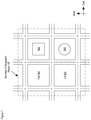
- grid 800 is overlaid onto geographic region 120 as shown in FIG. 8 .
- Grid 800 is a 10-by-10 grid that partitions geographic region 120 into a plurality of possible lateral locations of wireless terminal 101 .
- FIG. 8 also depicts the relationship of the footprints of boxy building 602 and cylindrical building 604 with respect to the grid.
- the coordinate positions of the various features of one or more objects (e.g., buildings, structures, etc.) in geographic region 120 are determined and stored in GIS database 321 .
- the positions of one or more features of the objects can be determined by referencing the three-dimensional survey of geographic region 120 , which is depicted in FIG. 9 .
- buildings 602 and 604 including the stored positions of their various features (e.g., exterior walls, etc.), are represented with coordinates.
- buildings 602 and 604 and objects in general, can be represented in a different way, such as by using a vector-based approach.
- one or more of the buildings in a geographic area can be described by a polygon shape of a building footprint, or rooftop, and the height of the building.
- any comparisons of distance can be made based on the polygon shape and/or polygon height stored, versus the coordinates stored.
- location-trait database 322 is constructed and stored into memory 303 of location engine 113 .
- the SSID that a wireless terminal is expected to be able to detect from Wi-Fi base stations 104 - 1 and 104 - 2 , for each possible location of the wireless terminal is determined in well-known fashion and stored into the database.
- the MAC address that a wireless terminal is expected to be able to detect from Wi-Fi base stations 104 - 1 and 104 - 2 , for each possible location of the wireless terminal is determined in well-known fashion and stored into the database.
- the identity of—and location-dependent traits for—each radio signal that each of cellular base stations 103 - 1 , 103 - 2 , and 103 - 3 , Wi-Fi base stations 104 - 1 and 104 - 2 is expected to be able to receive from a wireless terminal, for each possible lateral location of the wireless terminal, is determined in well-known fashion.
- FIG. 10 depicts a flowchart of the salient processes performed in accordance with operation 403 .
- each of cellular base stations 103 - 1 , 103 - 2 , and 103 - 3 and Wi-Fi base stations 104 - 1 and 104 - 2 transmits the identity of each signal it has received from wireless terminal 101 and the measurements of the location-dependent traits of those signals—though not necessarily simultaneously or synchronously with one another.
- operation 1001 is performed every 20 milliseconds, but it will be clear to those skilled in the art how to make and use alternative embodiments of the present invention that transmit the measurements at other times.
- location engine 113 receives the identities and measurements transmitted at operation 1001 .
- wireless terminal 101 transmits the identity of each signal it receives from cellular base stations 103 - 1 , 103 - 2 , and 103 - 3 and Wi-Fi base stations 104 - 1 and 104 - 2 and the measurements of the location-dependent traits of those signals.
- operation 1005 is performed every 20 milliseconds, but it will be clear to those skilled in the art how to make and use alternative embodiments of the present invention that transmit the measurements at other times.
- location engine 113 receives the identities and measurements transmitted at operation 1005 .
- Operations 1001 through 1007 are performed continuously, concurrently, and asynchronously, in accordance with the illustrative embodiment.
- the evidence of location that is collected can also include barometric pressure measurements made by wireless terminals 101 and 102 . It will be clear to those skilled in the art how to make and use embodiments of the present invention to perform operation 403 , including the collecting of barometric pressure measurements. See for example and without limitation, U.S. Pat. Nos. 9,432,811 and 9,237,423, which are incorporated by reference herein.
- FIG. 11 depicts a flowchart of the salient processes performed in accordance with operation 405 .
- location engine 113 generates a first estimate of the location of wireless terminal 101 based on:
- the location can be determined using a different technique than the radio frequency (RF) pattern matching described above and that is based on a measurement of a location-dependent trait of a radio signal and/or on the identity of a radio signal.
- the generating of the first estimate can be based on pattern matching, Global Navigation Satellite System [GNSS], GPS, multilateration such as time-difference of arrival (TDOA), cell ID, enhanced cell ID (E-CID), and so on, for example and without limitation.
- GNSS Global Navigation Satellite System
- TDOA time-difference of arrival
- E-CID enhanced cell ID
- the first estimate of the location of wireless terminal 101 comprises a set of geographical coordinates representing the latitude/longitude (“lat/lon”) of the wireless terminal.
- Latitude represents location along a first dimension (i.e., “north-south”)
- longitude represents location along a second dimension (i.e., “east-west”).
- the lat/lon can correspond to point on a grid square in geographic region 120 (as depicted in FIG. 8 ) or can be determined via an alternative technique as indicated above.
- the first estimate of the location of wireless terminal 101 also comprises an estimate of elevation. Elevation represents location along a third dimension (i.e., “z-axis”). It will be clear to those skilled in the art how to make and use embodiments of the present invention to perform operation 405 , including the estimating of elevation. See for example and without limitation, U.S. Pat. Nos. 9,432,811 and 9,237,423, which are incorporated by reference herein.
- the estimating of elevation can be based on barometric pressure measurements described above and in regard to operation 403 or can be based on an alternative technique.
- the first estimate of the location of wireless terminal 101 also comprises values for the uncertainties in one or more components of the location estimate (e.g., an uncertainty in latitude, an uncertainty in longitude, a horizontal uncertainty, a vertical uncertainty, an overall uncertainty, etc.).
- the horizontal uncertainty is based on the underlying lateral location estimation technique that results in lat/lon coordinates. For example, it can be based on the size of a grid square in geographic region 120 (as depicted in FIG. 8 ) or determined based on an alternative technique.
- the vertical uncertainty is based on the underlying elevation estimation technique.
- FIG. 12 depicts a flowchart of the salient processes performed in accordance with operation 407 .
- location engine 113 generates the data points that are members of a nonempty set of data points in space.
- the location engine generates the data points based on one or more probability distributions.
- the probability distributions are defined by at least one of i) the one or more geographical coordinates and ii) the uncertainty or uncertainties in the one or more geographical coordinates that are part of the first estimate of location generated in accordance with operation 405 .
- Location engine 113 generates the data points based on i) a first probability distribution that is defined by a first geographic coordinate value along a first dimension (e.g., x-axis, etc.), ii) a second normal distribution that is defined by a second geographic coordinate value along a second dimension (e.g., y-axis, etc.), and/or a third geographic coordinate value along a third dimension (e.g., z-axis, etc.), wherein the geographic coordinates are part of the first estimate of location.
- the data points generated are represented by coordinate values along the represented dimensions.
- location engine 113 applies a normal (or Gaussian) distribution, or an approximation thereof, as the probability distribution along one or more dimensions of the nonempty set of data points.
- the nonempty set of data points in space is a “point cloud” or “pixel cloud,” as is known in the art.
- the center of the set of data points coincides with, or at least is based on, one or more of the latitude, the longitude, and the elevation provided in the contained in first estimate of location of wireless terminal 101 , in any combination.
- the first geographic coordinate value defines the mean of the first probability distribution
- the second geographic coordinate value defines the mean of the second probability distribution
- the third geographic coordinate value defines the mean of the third probability distribution.
- a horizontal component of the uncertainty (i.e., in the one or more geographical coordinates of the first estimate), H unc , defines the standard deviation of a probability distribution along a horizontal dimension.
- a vertical component of the uncertainty in the one or more geographical coordinates, V unc can be used to define a standard deviation of a probability distribution along a vertical dimension.
- Location engine 113 generates M data points, in the form of coordinate values, for the set of data points in space.
- the set of P mx values is characterized by a first probability distribution
- the set of P my values is characterized by a second probability distribution
- the set of P mz values is characterized by a third probability distribution.
- location engine 113 assigns weights to the data points in the set of data points generated in accordance with operation 1201 .
- the assigning of the weights is based on the position of each data point to which a respective weight is assigned in relation to one or more objects represented in GIS database 321 .
- each weight W(P mx , P my , P mz ) assigned to data point (P mx , P my , P mz ) can be regarded as a probability of survival that is assigned to the corresponding data point.
- FIG. 13 depicts outlines of buildings 602 and 604 from an elevation view, along with various regions within and outside of each building which are used to determine the corresponding probabilities of survival assigned to the data points.
- the coordinates of the data points coexist with the coordinates of the various features stored in GIS database 321 , such as features associated with buildings 602 and 604 .
- building 602 is partially defined by exterior wall 1301 , whose coordinates are stored in GIS database 321 .
- Location engine 113 assigns a first probability of survival (e.g., 100 percent, etc.) to all generated data points existing in interior region 1302 within the exterior walls, including wall 1301 , of building 602 .
- the location engine assigns a second probability of survival (e.g., 100 percent, etc.) to all generated data points existing on the outside within a predetermined distance (e.g., two meters, etc.) from the exterior walls, wherein this region that is adjacent to and on the outside of wall 1301 is denoted by exterior region 1303 .
- the second probability of survival (e.g., 100 percent, etc.) is equal to the first probability of survival (e.g., 100 percent, etc.), while in some other embodiments the second probability (e.g., 95 percent, etc.) is different or less than the first probability (e.g., 100 percent, etc.).
- location engine 113 assigns a third probability of survival (e.g., five percent, etc.) to all data points existing on boundary surface 1304 .
- the third probability of survival is relatively low in comparison to the second probability of survival.
- Location engine 113 assigns a fourth probability of survival that is a function of the outward radial distance from boundary surface 1304 .
- the fourth probability decreases to zero relatively quickly as a function of the radial distance from surface 1304 .
- the probability values are based on the general likelihoods of whether a wireless terminal would be occupying the various regions depicted. For example, data points coinciding with at least some of the interior regions of building 602 would be assigned high probabilities of survival because the interior is occupiable by a person, with whom a wireless terminal would be collocated. Conversely in the example, data points coinciding with at least some of the regions exterior to building 602 would be assigned low probabilities of survival because a midair region distant from any building and ground is generally not occupiable by a person.
- Building 604 is partially defined by exterior wall 1311 . Similar to how it assigns probabilities of survival to regions associated with building 602 , location engine 113 assigns first through fourth probabilities of survival to the data points existing in and around building 604 , based on exterior wall 1311 , interior region 1312 , exterior region 1313 , and boundary surface 1314 . As those who are skilled in the art will appreciate, after reading this specification, one or more of the probabilities of survival associated with building 602 can be the same as, or different from, one or more of the probabilities of survival associated with building 604 , in any combination.
- location engine 113 assigns a fifth probability of survival (e.g., 100 percent, etc.) to all generated data points existing within a predetermined distance (e.g., two meters, etc.) above ground level 1321 , wherein this region that is adjacent to and above ground level 1321 is denoted by region 1322 .
- the fifth probability of survival e.g., 100 percent, etc.
- the second probability of survival e.g., 100 percent, etc.
- Location engine 113 assigns a sixth probability of survival (e.g., five percent, etc.) to all data points existing on boundary surface 1323 .
- the sixth probability of survival is relatively low in comparison to the fifth probability of survival.
- Location engine 113 assigns a seventh probability of survival that is a function of the outward radial distance from boundary surface 1323 .
- the seventh probability decreases to zero relatively quickly as a function of the radial distance from surface 1323 .
- the data points existing in at least some of interior regions 1302 and/or 1312 can be assigned probabilities of survival of less than 100 percent.
- data points existing within a sub-region within which no wireless terminal can exist such as solid building material, can be assigned a probability of survival equal to zero.
- data points existing within a sub-region within which wireless terminals are not often present such as long-term storage space or physical plant equipment areas, can be assigned a probability of survival equal to a non-zero number less than 100 percent (e.g., 50 percent, etc.).
- location engine 113 assigns weights to the data points, wherein the weights are regarded as probabilities of survival. As those who are skilled in the art will appreciate, after reading this specification, a different type of weight than probability of survival can be assigned to the data points.
- location engine 113 determines for each data point m, for m from 1 through M, whether or not the data point is to be retained, based in part on its weight assigned in accordance with operation 1203 .
- Location engine 113 removes data point (P mx , P my , P mz ) from the set of data points, provided that DIFF (Pmx,Pmy,Pmz) is greater than zero. Otherwise, location engine 113 retains the data point. In accordance with the illustrative embodiment, location engine 113 removes at least one of the data points from the set of data points, based on one or more of the weights of the data points, resulting in a nonempty proper subset of the data points.
- location engine 113 generates a second estimate of location of wireless terminal 101 based on the distribution of the data points retained in accordance with operation 1205 . To do so, the location engine determines the median position of all of the retained data points along each dimension (i.e., x-axis, y-axis, z-axis). The median position is used as the second estimate of location or at least provides the basis for the second estimate of location. In some alternative embodiments of the present invention, location engine 113 determines the mean position of all of the retained data points along each dimension, instead of the median. In some other alternative embodiments, location engine 113 operates on a smaller subset of the retained data points, in order to determine the second estimate of location.
- FIGS. 14A and 14B depict a first example of how location engine 113 generates the second estimate of location of wireless terminal 101 .
- the outline of building 602 is depicted from an elevation view, along with wall 1301 and boundary 1304 from FIG. 13 .
- FIG. 14A also depicts point cloud 1411 , which consists of the data points generated in accordance with operation 1201 .
- point cloud 1411 is depicted as an outline of the furthest extent of the constituent data points and as existing across two dimensions, even though the data points themselves exist in memory as individual points and across three dimensions.
- Point cloud 1411 is centered around first estimate of location 1401 , which is generated in accordance with operation 405 . As depicted, the first estimate of location has wireless terminal 101 at an upper floor of building 602 .
- FIG. 14B also depicts modified point cloud 1421 , which consists of the data points remaining after operation 1205 .
- the median position of the points in point cloud 1421 is at position 1402 , which represents the second estimate of location provided in accordance with operation 1207 .
- Position 1402 is shifted downward in relation to position 1401 . This is because in accordance with operations 1203 and 1205 , at least some of the data points outside of boundary 1304 are removed from point cloud 1411 , leaving the remaining data points to determine the position that is represented in the second estimate.
- FIGS. 15A and 15B depict a second example of how location engine 113 generates the second estimate of location of wireless terminal 101 .
- the outline of building 602 is depicted from an elevation view, along with wall 1301 and boundary 1304 from FIG. 13 .
- FIG. 15A also depicts point cloud 1511 , which consists of the data points generated in accordance with operation 1201 .
- point cloud 1511 is depicted as an outline of the furthest extent of the constituent data points and as existing across two dimensions, even though the data points themselves exist in memory as individual points and across three dimensions.
- Point cloud 1511 is centered around first estimate of location 1501 , which is generated in accordance with operation 405 .
- the first estimate of location has wireless terminal 101 laterally outside an upper floor of building 602 .
- FIG. 15B also depicts modified point cloud 1521 , which consists of the data points remaining after operation 1205 .
- the median position of the points in point cloud 1521 is at position 1502 , which represents the second estimate of location provided in accordance with operation 1207 .
- Position 1502 is shifted both inward toward building 602 and downward, in relation to position 1501 . This is because in accordance with operations 1203 and 1205 , at least some of the data points outside of boundary 1304 are removed from point cloud 1411 , on both the side and top of the point cloud as depicted. This leaves the remaining data points to determine the position that is represented in the second estimate.
- control of task execution proceeds to operation 409 .
Landscapes
- Engineering & Computer Science (AREA)
- Computer Networks & Wireless Communication (AREA)
- Signal Processing (AREA)
- Remote Sensing (AREA)
- Radar, Positioning & Navigation (AREA)
- Physics & Mathematics (AREA)
- General Physics & Mathematics (AREA)
- Databases & Information Systems (AREA)
- Theoretical Computer Science (AREA)
- Data Mining & Analysis (AREA)
- General Engineering & Computer Science (AREA)
- Mobile Radio Communication Systems (AREA)
Abstract
Description
-
- i. a measurement of a location-dependent trait (e.g., signal strength, etc.) of a radio signal as received by the wireless terminal,
- ii. the identity of a radio signal as received by the wireless terminal (e.g., in a service environment in which different radio signals transmitted from different locations are assigned different identities, etc.), or
- iii. the identity (e.g., service set identifier [SSID], media access control [MAC] address, etc.) of the base station in communication with the wireless terminal (e.g., in a service environment in which different base stations at different locations are assigned different identities, etc.).
-
- i. the location of the transmitter of the signal, or
- ii. the location of the receiver of the signal, or
- iii. both i and ii.
For example and without limitation, the amplitude and phase of a radio signal are generally location-dependent traits of the signal. In contrast, the frequency of a given radio signal is generally not a location-dependent trait of the signal.
-
- i. one or more location-dependent traits of one or more radio signals received or transmitted by a wireless terminal, or
- ii. the identity of one or more radio signals received or transmitted by a wireless terminal, or
- iii. both i and ii,
at each of a plurality of locations.
-
- i. receiving one or more radio signals transmitted by
wireless terminals - ii. identifying each radio signal transmitted by
wireless terminals location engine 113, and - iii. measuring one or more location-dependent traits of each radio signal transmitted by
wireless terminals location engine 113, and - iv. transmitting one or more signals to
wireless terminals location engine 113, and - v. broadcasting one or more signals that wireless terminals can use for various purposes (e.g., mobile assisted handoff, location determination, etc.).
It will be clear to those skilled in the art how to make and use cellular base stations 103-1, 103-2, and 103-3.
- i. receiving one or more radio signals transmitted by
-
- i. receiving one or more radio signals transmitted by
wireless terminals - ii. identifying each radio signal transmitted by
wireless terminals location engine 113, and - iii. measuring one or more location-dependent traits of each radio signal transmitted by
wireless terminals location engine 113, and - iv. transmitting one or more signals to
wireless terminals location engine 113, and - v. broadcasting one or more signals that wireless terminals can use for various purposes (e.g., mobile assisted handoff, location determination, etc.).
- i. receiving one or more radio signals transmitted by
-
- i. receiving one or more radio signals transmitted by cellular base stations 103-1, 103-2, and 103-3, Wi-Fi base stations 104-1 and 104-2, and
GPS constellation 121, and - ii. identifying each radio signal transmitted by cellular base stations 103-1, 103-2, and 103-3, Wi-Fi base stations 104-1 and 104-2, and
GPS constellation 121, in well-known fashion, and of transmitting the identity of those signals tolocation engine 113, and - iii. measuring one or more location-dependent traits of each radio signal transmitted by cellular base stations 103-1, 103-2, and 103-3, Wi-Fi base stations 104-1 and 104-2, and
GPS constellation 121, in well-known fashion, and of transmitting the measurements tolocation engine 113, and - iv. transmitting one or more signals to cellular base stations 103-1, 103-2, and 103-3, Wi-Fi base stations 104-1 and 104-2 in accordance with specific parameters (e.g., signal strength, frequency, coding, modulation, etc.), in well-known fashion, and of transmitting those parameters to
location engine 113.
It will be clear to those skilled in the art how to make and usewireless terminal 101 and, by extension,wireless terminal 102.
- i. receiving one or more radio signals transmitted by cellular base stations 103-1, 103-2, and 103-3, Wi-Fi base stations 104-1 and 104-2, and
-
- i.
operating system 311, and - ii.
application software 312, and - iii. location-
trait database 322 indatabase 313, and - iv.
GIS database 321 indatabase 313.
It will be clear to those skilled in the art how to make and usememory 303.
- i.
-
- i. the first estimate of the location of
wireless terminal 101 generated in accordance withoperation 405, - ii. one or more objects in
GIS database 321 constructed in accordance withoperation 401.
Operation 407 is described in detail below and in the accompanying figures.
- i. the first estimate of the location of
-
- i. the location-dependent information conveyed by a radio signal exchanged between a base station (e.g., cellular base station 103-i, Wi-Fi base station 104-j, etc.) and wireless terminal 101 (e.g., the empirical data for the radio signals received in
operation 403, etc.), and - ii. location-
trait database 322,
in well-known fashion. It will be clear to those skilled in the art how to make and use embodiments of the present invention to performoperation 405. See for example and without limitation, U.S. Pat. Nos. 6,944,465, 7,460,505, 7,383,051, 7,257,414, 7,753,278, 7,433,695, 7,848,762, and 8,630,665, each of which are incorporated by reference.
- i. the location-dependent information conveyed by a radio signal exchanged between a base station (e.g., cellular base station 103-i, Wi-Fi base station 104-j, etc.) and wireless terminal 101 (e.g., the empirical data for the radio signals received in
P mx =N m(X,H unc) (Eq. 1)
P my =N m(Y,H unc) (Eq. 2)
P mz =N m(Z,V unc) (Eq. 3)
wherein:
-
- (X, Y, Z) represents the geographical coordinates of latitude, longitude, and elevation, respectively, of the first estimate of location of
wireless terminal 101, - Hunc represents the horizontal (lateral) uncertainty across latitude and longitude,
- Vunc represents the vertical uncertainty along elevation,
- Nm(μ, σ) is a random variable of normal distribution with mean μ and standard deviation σ, generated for data point m.
- (X, Y, Z) represents the geographical coordinates of latitude, longitude, and elevation, respectively, of the first estimate of location of
DIFF(Pmx,Pmy,Pmz)=RND(P mx ,P my ,P mz)−W(P mx ,P my ,P mz) (Eq. 4)
wherein:
-
- RND(Pmx, Pmy, Pmz) is a random number (i.e., a randomly-generated value) that is used for data point (Pmx, Pmy, Pmz),
- the function RND is based on a uniform distribution, and
- W(Pmx, Pmy, Pmz) is the weight assigned to data point (Pmx, Pmy, Pmz), normalized to the same range as RND(Pmx, Pmy, Pmz).
Claims (20)
Priority Applications (2)
| Application Number | Priority Date | Filing Date | Title |
|---|---|---|---|
| US16/353,598 US10602477B2 (en) | 2018-04-05 | 2019-03-14 | Method of considering boundaries represented in a geographic information system database, in estimating location |
| US16/743,114 US10716090B2 (en) | 2018-04-05 | 2020-01-15 | Method of considering the positions of data points in relation to boundaries represented in a geographic information system database, in estimating location |
Applications Claiming Priority (2)
| Application Number | Priority Date | Filing Date | Title |
|---|---|---|---|
| US201862653192P | 2018-04-05 | 2018-04-05 | |
| US16/353,598 US10602477B2 (en) | 2018-04-05 | 2019-03-14 | Method of considering boundaries represented in a geographic information system database, in estimating location |
Related Child Applications (1)
| Application Number | Title | Priority Date | Filing Date |
|---|---|---|---|
| US16/743,114 Continuation US10716090B2 (en) | 2018-04-05 | 2020-01-15 | Method of considering the positions of data points in relation to boundaries represented in a geographic information system database, in estimating location |
Publications (2)
| Publication Number | Publication Date |
|---|---|
| US20190313361A1 US20190313361A1 (en) | 2019-10-10 |
| US10602477B2 true US10602477B2 (en) | 2020-03-24 |
Family
ID=67845367
Family Applications (4)
| Application Number | Title | Priority Date | Filing Date |
|---|---|---|---|
| US16/047,168 Active US10412699B1 (en) | 2018-04-05 | 2018-07-27 | Enhancing an estimate of the location of a wireless terminal by using one or more types of identifiers of a wireless network |
| US16/353,598 Active US10602477B2 (en) | 2018-04-05 | 2019-03-14 | Method of considering boundaries represented in a geographic information system database, in estimating location |
| US16/523,359 Active US10517063B2 (en) | 2018-04-05 | 2019-07-26 | Enhancing an estimate of the location of a wireless terminal by using one or more types of identifiers of a wireless network |
| US16/743,114 Active US10716090B2 (en) | 2018-04-05 | 2020-01-15 | Method of considering the positions of data points in relation to boundaries represented in a geographic information system database, in estimating location |
Family Applications Before (1)
| Application Number | Title | Priority Date | Filing Date |
|---|---|---|---|
| US16/047,168 Active US10412699B1 (en) | 2018-04-05 | 2018-07-27 | Enhancing an estimate of the location of a wireless terminal by using one or more types of identifiers of a wireless network |
Family Applications After (2)
| Application Number | Title | Priority Date | Filing Date |
|---|---|---|---|
| US16/523,359 Active US10517063B2 (en) | 2018-04-05 | 2019-07-26 | Enhancing an estimate of the location of a wireless terminal by using one or more types of identifiers of a wireless network |
| US16/743,114 Active US10716090B2 (en) | 2018-04-05 | 2020-01-15 | Method of considering the positions of data points in relation to boundaries represented in a geographic information system database, in estimating location |
Country Status (1)
| Country | Link |
|---|---|
| US (4) | US10412699B1 (en) |
Families Citing this family (3)
| Publication number | Priority date | Publication date | Assignee | Title |
|---|---|---|---|---|
| WO2019187098A1 (en) * | 2018-03-30 | 2019-10-03 | 本田技研工業株式会社 | System for managing internal combustion engine, server device, and method for managing internal combustion engine |
| US11191005B2 (en) * | 2019-05-29 | 2021-11-30 | At&T Intellectual Property I, L.P. | Cyber control plane for universal physical space |
| US12007463B2 (en) * | 2020-07-27 | 2024-06-11 | Huawei Technologies Co., Ltd. | Sensing-assisted positioning of mobile devices |
Citations (6)
| Publication number | Priority date | Publication date | Assignee | Title |
|---|---|---|---|---|
| US7120449B1 (en) * | 1999-10-15 | 2006-10-10 | Nokia Corporation | Location determination in telecommunication network |
| US8330654B2 (en) * | 2009-08-10 | 2012-12-11 | Industrial Technology Research Institute | Method and apparatus for positioning mobile device |
| US20130178231A1 (en) * | 2010-07-27 | 2013-07-11 | University Of Regina | Method and system for cooperative stochastic positioning in a mobile environment |
| US20140378166A1 (en) | 2013-06-19 | 2014-12-25 | Samsung Electronics Co., Ltd. | Method, storage medium, server, and electronic device for implementing location based service within building |
| US20160057572A1 (en) | 2014-08-20 | 2016-02-25 | Microsoft Corporation | Geo-fencing notifications subscriptions |
| US20180014161A1 (en) | 2016-06-10 | 2018-01-11 | Apple Inc. | Harvesting labels for significant locations |
Family Cites Families (6)
| Publication number | Priority date | Publication date | Assignee | Title |
|---|---|---|---|---|
| KR101099151B1 (en) * | 2004-10-29 | 2011-12-27 | 스카이후크 와이어리스, 인크. | Location beacon database and server, method of building location beacon database, and location based service using same |
| ATE556298T1 (en) * | 2008-03-11 | 2012-05-15 | Gmv Aerospace And Defence S A | METHOD FOR DETERMINING COMPLIANCE WITH ASSURANCED INTEGRITY |
| US8493205B2 (en) * | 2010-01-29 | 2013-07-23 | Ntt Docomo, Inc. | Search area reduction based on indoor detection for estimating the location of a wireless terminal |
| US9078099B2 (en) * | 2012-07-16 | 2015-07-07 | Qualcomm Incorporated | Localization method employing radio signal strength measurements of electric and gas meters |
| CN105095242B (en) * | 2014-04-30 | 2018-07-27 | 国际商业机器公司 | A kind of method and apparatus of label geographic area |
| CN108282843B (en) * | 2017-01-18 | 2021-07-09 | 阿里巴巴(中国)有限公司 | Network query method, device and server |
-
2018
- 2018-07-27 US US16/047,168 patent/US10412699B1/en active Active
-
2019
- 2019-03-14 US US16/353,598 patent/US10602477B2/en active Active
- 2019-07-26 US US16/523,359 patent/US10517063B2/en active Active
-
2020
- 2020-01-15 US US16/743,114 patent/US10716090B2/en active Active
Patent Citations (7)
| Publication number | Priority date | Publication date | Assignee | Title |
|---|---|---|---|---|
| US7120449B1 (en) * | 1999-10-15 | 2006-10-10 | Nokia Corporation | Location determination in telecommunication network |
| US8330654B2 (en) * | 2009-08-10 | 2012-12-11 | Industrial Technology Research Institute | Method and apparatus for positioning mobile device |
| US20130178231A1 (en) * | 2010-07-27 | 2013-07-11 | University Of Regina | Method and system for cooperative stochastic positioning in a mobile environment |
| US20140378166A1 (en) | 2013-06-19 | 2014-12-25 | Samsung Electronics Co., Ltd. | Method, storage medium, server, and electronic device for implementing location based service within building |
| US9344854B2 (en) * | 2013-06-19 | 2016-05-17 | Samsung Electronics Co., Ltd | Method, storage medium, server, and electronic device for implementing location based service within building |
| US20160057572A1 (en) | 2014-08-20 | 2016-02-25 | Microsoft Corporation | Geo-fencing notifications subscriptions |
| US20180014161A1 (en) | 2016-06-10 | 2018-01-11 | Apple Inc. | Harvesting labels for significant locations |
Non-Patent Citations (1)
| Title |
|---|
| USPTO "Notice of Allowance and Fee(s) Due" dated May 2, 2019, U.S. Appl. No. 16/047,168. |
Also Published As
| Publication number | Publication date |
|---|---|
| US10716090B2 (en) | 2020-07-14 |
| US20200187148A1 (en) | 2020-06-11 |
| US20190349882A1 (en) | 2019-11-14 |
| US10412699B1 (en) | 2019-09-10 |
| US10517063B2 (en) | 2019-12-24 |
| US20190313361A1 (en) | 2019-10-10 |
Similar Documents
| Publication | Publication Date | Title |
|---|---|---|
| US9432811B2 (en) | Estimating the lateral location of a wireless terminal based on temperature and atmospheric pressure | |
| JP4578505B2 (en) | Prediction method of whereabouts of wireless terminal | |
| JP5419891B2 (en) | Providing Wi-Fi location information to mobile devices to estimate the location of mobile devices | |
| EP2449834B1 (en) | Tdoa-based reconstruction of base station location data | |
| KR102601423B1 (en) | Method and system for measuring the location of a terminal in a wireless communication system | |
| US10716090B2 (en) | Method of considering the positions of data points in relation to boundaries represented in a geographic information system database, in estimating location | |
| EP1917825A1 (en) | Estimation of the location of a wireless terminal for locations not designated as improbable | |
| JP2007316069A (en) | Prediction method for location of radio terminal | |
| JP2008017455A (en) | Method for estimating location of wireless terminal | |
| JP2007316067A (en) | Method for specifying position of wireless terminal | |
| WO2007012058A1 (en) | Estimating the location of a wireless terminal based on signal path impairment | |
| US10547735B2 (en) | Calibration of measurement bias of a barometric sensor in a wireless terminal | |
| JP2007316070A (en) | Method for predicting position of wireless terminal | |
| US10863327B2 (en) | Estimation of building floors based on difference in barometric pressure measured by wireless terminals | |
| US8493205B2 (en) | Search area reduction based on indoor detection for estimating the location of a wireless terminal | |
| US10715960B2 (en) | Estimation of a stack-effect compensation model based on measurements provided by a wireless terminal | |
| US11927680B2 (en) | Estimation of barometric pressure measurement bias based on global navigation satellite system signals | |
| US10123298B1 (en) | Estimating the location of a wireless terminal based on detection of whether it is moving or stationary | |
| US11054255B2 (en) | Estimating the elevation of a wireless terminal by determining a bias of pressure measurement from a probability distribution | |
| US20210325565A1 (en) | Estimation of Reference Barometric Pressure by Using Dissimilar Pressure References | |
| Benikovsky | Radio Map Framework for GSM Positioning |
Legal Events
| Date | Code | Title | Description |
|---|---|---|---|
| FEPP | Fee payment procedure |
Free format text: ENTITY STATUS SET TO UNDISCOUNTED (ORIGINAL EVENT CODE: BIG.); ENTITY STATUS OF PATENT OWNER: LARGE ENTITY |
|
| AS | Assignment |
Owner name: POLARIS WIRELESS INC, CALIFORNIA Free format text: ASSIGNMENT OF ASSIGNORS INTEREST;ASSIGNORS:BLAHA, JEROME ARTHUR, JR;GORDON, SCOT DOUGLAS;LU, JONATHAN SHIAO-EN;AND OTHERS;SIGNING DATES FROM 20190311 TO 20190313;REEL/FRAME:050509/0425 |
|
| STPP | Information on status: patent application and granting procedure in general |
Free format text: RESPONSE TO NON-FINAL OFFICE ACTION ENTERED AND FORWARDED TO EXAMINER |
|
| STPP | Information on status: patent application and granting procedure in general |
Free format text: NOTICE OF ALLOWANCE MAILED -- APPLICATION RECEIVED IN OFFICE OF PUBLICATIONS |
|
| STPP | Information on status: patent application and granting procedure in general |
Free format text: PUBLICATIONS -- ISSUE FEE PAYMENT VERIFIED |
|
| STCF | Information on status: patent grant |
Free format text: PATENTED CASE |
|
| FEPP | Fee payment procedure |
Free format text: SURCHARGE FOR LATE PAYMENT, LARGE ENTITY (ORIGINAL EVENT CODE: M1554); ENTITY STATUS OF PATENT OWNER: LARGE ENTITY |
|
| MAFP | Maintenance fee payment |
Free format text: PAYMENT OF MAINTENANCE FEE, 4TH YEAR, LARGE ENTITY (ORIGINAL EVENT CODE: M1551); ENTITY STATUS OF PATENT OWNER: LARGE ENTITY Year of fee payment: 4 |