US10119829B2 - Route planning method and device for navigation system and storage medium - Google Patents

Route planning method and device for navigation system and storage medium Download PDF

Info

Publication number
US10119829B2
US10119829B2 US15/112,512 US201515112512A US10119829B2 US 10119829 B2 US10119829 B2 US 10119829B2 US 201515112512 A US201515112512 A US 201515112512A US 10119829 B2 US10119829 B2 US 10119829B2
Authority
US
United States
Prior art keywords
cell
inter
grid
record
adjacency
Prior art date
Legal status (The legal status is an assumption and is not a legal conclusion. Google has not performed a legal analysis and makes no representation as to the accuracy of the status listed.)
Active, expires
Application number
US15/112,512
Other versions
US20160334237A1 (en
Inventor
Lixue Wang
Current Assignee (The listed assignees may be inaccurate. Google has not performed a legal analysis and makes no representation or warranty as to the accuracy of the list.)
Xian Zhongxing New Software Co Ltd
Original Assignee
Xian Zhongxing New Software Co Ltd
Priority date (The priority date is an assumption and is not a legal conclusion. Google has not performed a legal analysis and makes no representation as to the accuracy of the date listed.)
Filing date
Publication date
Application filed by Xian Zhongxing New Software Co Ltd filed Critical Xian Zhongxing New Software Co Ltd
Publication of US20160334237A1 publication Critical patent/US20160334237A1/en
Assigned to ZTE CORPORATION reassignment ZTE CORPORATION ASSIGNMENT OF ASSIGNORS INTEREST (SEE DOCUMENT FOR DETAILS). Assignors: WANG, Lixue
Assigned to XI'AN ZHONGXING NEW SOFTWARE CO.LTD. reassignment XI'AN ZHONGXING NEW SOFTWARE CO.LTD. ASSIGNMENT OF ASSIGNORS INTEREST (SEE DOCUMENT FOR DETAILS). Assignors: ZTE CORPORATION
Application granted granted Critical
Publication of US10119829B2 publication Critical patent/US10119829B2/en
Active legal-status Critical Current
Adjusted expiration legal-status Critical

Links

Images

Classifications

    • GPHYSICS
    • G01MEASURING; TESTING
    • G01CMEASURING DISTANCES, LEVELS OR BEARINGS; SURVEYING; NAVIGATION; GYROSCOPIC INSTRUMENTS; PHOTOGRAMMETRY OR VIDEOGRAMMETRY
    • G01C21/00Navigation; Navigational instruments not provided for in groups G01C1/00 - G01C19/00
    • G01C21/26Navigation; Navigational instruments not provided for in groups G01C1/00 - G01C19/00 specially adapted for navigation in a road network
    • G01C21/34Route searching; Route guidance
    • G01C21/36Input/output arrangements for on-board computers
    • G01C21/3605Destination input or retrieval
    • G01C21/362Destination input or retrieval received from an external device or application, e.g. PDA, mobile phone or calendar application
    • GPHYSICS
    • G01MEASURING; TESTING
    • G01CMEASURING DISTANCES, LEVELS OR BEARINGS; SURVEYING; NAVIGATION; GYROSCOPIC INSTRUMENTS; PHOTOGRAMMETRY OR VIDEOGRAMMETRY
    • G01C21/00Navigation; Navigational instruments not provided for in groups G01C1/00 - G01C19/00
    • G01C21/26Navigation; Navigational instruments not provided for in groups G01C1/00 - G01C19/00 specially adapted for navigation in a road network
    • G01C21/28Navigation; Navigational instruments not provided for in groups G01C1/00 - G01C19/00 specially adapted for navigation in a road network with correlation of data from several navigational instruments
    • G01C21/30Map- or contour-matching
    • GPHYSICS
    • G01MEASURING; TESTING
    • G01CMEASURING DISTANCES, LEVELS OR BEARINGS; SURVEYING; NAVIGATION; GYROSCOPIC INSTRUMENTS; PHOTOGRAMMETRY OR VIDEOGRAMMETRY
    • G01C21/00Navigation; Navigational instruments not provided for in groups G01C1/00 - G01C19/00
    • G01C21/26Navigation; Navigational instruments not provided for in groups G01C1/00 - G01C19/00 specially adapted for navigation in a road network
    • G01C21/34Route searching; Route guidance
    • G01C21/3446Details of route searching algorithms, e.g. Dijkstra, A*, arc-flags or using precalculated routes
    • GPHYSICS
    • G08SIGNALLING
    • G08GTRAFFIC CONTROL SYSTEMS
    • G08G1/00Traffic control systems for road vehicles
    • G08G1/09Arrangements for giving variable traffic instructions
    • G08G1/0962Arrangements for giving variable traffic instructions having an indicator mounted inside the vehicle, e.g. giving voice messages
    • G08G1/0968Systems involving transmission of navigation instructions to the vehicle
    • G08G1/096833Systems involving transmission of navigation instructions to the vehicle where different aspects are considered when computing the route
    • G08G1/096844Systems involving transmission of navigation instructions to the vehicle where different aspects are considered when computing the route where the complete route is dynamically recomputed based on new data
    • HELECTRICITY
    • H04ELECTRIC COMMUNICATION TECHNIQUE
    • H04LTRANSMISSION OF DIGITAL INFORMATION, e.g. TELEGRAPHIC COMMUNICATION
    • H04L43/00Arrangements for monitoring or testing data switching networks
    • H04L43/02Capturing of monitoring data
    • H04L43/028Capturing of monitoring data by filtering
    • HELECTRICITY
    • H04ELECTRIC COMMUNICATION TECHNIQUE
    • H04LTRANSMISSION OF DIGITAL INFORMATION, e.g. TELEGRAPHIC COMMUNICATION
    • H04L43/00Arrangements for monitoring or testing data switching networks
    • H04L43/04Processing captured monitoring data, e.g. for logfile generation
    • H04L43/045Processing captured monitoring data, e.g. for logfile generation for graphical visualisation of monitoring data
    • HELECTRICITY
    • H04ELECTRIC COMMUNICATION TECHNIQUE
    • H04LTRANSMISSION OF DIGITAL INFORMATION, e.g. TELEGRAPHIC COMMUNICATION
    • H04L67/00Network arrangements or protocols for supporting network services or applications
    • H04L67/01Protocols
    • H04L67/06Protocols specially adapted for file transfer, e.g. file transfer protocol [FTP]
    • HELECTRICITY
    • H04ELECTRIC COMMUNICATION TECHNIQUE
    • H04WWIRELESS COMMUNICATION NETWORKS
    • H04W36/00Hand-off or reselection arrangements
    • H04W36/0005Control or signalling for completing the hand-off
    • H04W36/0083Determination of parameters used for hand-off, e.g. generation or modification of neighbour cell lists
    • H04W36/0085Hand-off measurements
    • H04W36/0088Scheduling hand-off measurements
    • HELECTRICITY
    • H04ELECTRIC COMMUNICATION TECHNIQUE
    • H04WWIRELESS COMMUNICATION NETWORKS
    • H04W36/00Hand-off or reselection arrangements
    • H04W36/0005Control or signalling for completing the hand-off
    • H04W36/0083Determination of parameters used for hand-off, e.g. generation or modification of neighbour cell lists
    • H04W36/0085Hand-off measurements
    • H04W36/0094Definition of hand-off measurement parameters
    • HELECTRICITY
    • H04ELECTRIC COMMUNICATION TECHNIQUE
    • H04WWIRELESS COMMUNICATION NETWORKS
    • H04W36/00Hand-off or reselection arrangements
    • H04W36/24Reselection being triggered by specific parameters
    • H04W36/32Reselection being triggered by specific parameters by location or mobility data, e.g. speed data
    • H04W36/326Reselection being triggered by specific parameters by location or mobility data, e.g. speed data by proximity to another entity
    • HELECTRICITY
    • H04ELECTRIC COMMUNICATION TECHNIQUE
    • H04WWIRELESS COMMUNICATION NETWORKS
    • H04W4/00Services specially adapted for wireless communication networks; Facilities therefor
    • H04W4/02Services making use of location information
    • HELECTRICITY
    • H04ELECTRIC COMMUNICATION TECHNIQUE
    • H04WWIRELESS COMMUNICATION NETWORKS
    • H04W4/00Services specially adapted for wireless communication networks; Facilities therefor
    • H04W4/02Services making use of location information
    • H04W4/023Services making use of location information using mutual or relative location information between multiple location based services [LBS] targets or of distance thresholds
    • HELECTRICITY
    • H04ELECTRIC COMMUNICATION TECHNIQUE
    • H04WWIRELESS COMMUNICATION NETWORKS
    • H04W4/00Services specially adapted for wireless communication networks; Facilities therefor
    • H04W4/02Services making use of location information
    • H04W4/024Guidance services
    • HELECTRICITY
    • H04ELECTRIC COMMUNICATION TECHNIQUE
    • H04WWIRELESS COMMUNICATION NETWORKS
    • H04W4/00Services specially adapted for wireless communication networks; Facilities therefor
    • H04W4/02Services making use of location information
    • H04W4/029Location-based management or tracking services
    • H04W4/046
    • HELECTRICITY
    • H04ELECTRIC COMMUNICATION TECHNIQUE
    • H04WWIRELESS COMMUNICATION NETWORKS
    • H04W4/00Services specially adapted for wireless communication networks; Facilities therefor
    • H04W4/30Services specially adapted for particular environments, situations or purposes
    • H04W4/40Services specially adapted for particular environments, situations or purposes for vehicles, e.g. vehicle-to-pedestrians [V2P]
    • HELECTRICITY
    • H04ELECTRIC COMMUNICATION TECHNIQUE
    • H04WWIRELESS COMMUNICATION NETWORKS
    • H04W64/00Locating users or terminals or network equipment for network management purposes, e.g. mobility management
    • HELECTRICITY
    • H04ELECTRIC COMMUNICATION TECHNIQUE
    • H04WWIRELESS COMMUNICATION NETWORKS
    • H04W8/00Network data management
    • H04W8/18Processing of user or subscriber data, e.g. subscribed services, user preferences or user profiles; Transfer of user or subscriber data

Definitions

  • the present disclosure relates to the interdisciplinary field of smart transportation, car networking, a Location-Based Service (LBS), and mobile communications, and in particular to a route planning method and device for a navigation system, as well as a non-transitory computer-readable storage medium.
  • LBS Location-Based Service
  • GIS Geographic Information System
  • the road condition data from the TMC are released by a traffic management department, with real-time data mainly coming from tollgate monitoring and police deployment, leading to good real-time performance.
  • TMC Traffic Message Channel
  • the commercial road condition data mainly come from Float Car Data (FCD), with road condition information being collected generally using an on-cab device deployed by a cab company. Constrained by commercial, technical, and historical factors, the commercial road condition data can provide but road condition information on only a few cities, often with a large delay and poor real-time performance.
  • FCD Float Car Data
  • Embodiments herein provide a route planning method and device for a navigation system, as well as a non-transitory computer-readable storage medium, capable of automatically sensing an actual traffic condition in a relevant area and performing real-time route planning while performing accurate effective interactive navigation according to a change in road condition in real time.
  • a route planning method for a navigation system includes:
  • the method may further include: before the modelling an inter-cell adjacency according to the handover record,
  • the modelling an inter-cell adjacency according to the handover record may include:
  • the modelling the inter-cell adjacency within the period of time according to the snapshot may include:
  • the inter-cell adjacency index may be a probability of transfer between two cells, or a duration needed for transfer between two cells.
  • the converting the grid-level path into an actual route from the departure point to the destination point in the actual geographic space may include:
  • GIS Geographic Information System
  • a route planning device for a navigation system includes a grid modelling module, a grid path finding module, and a path converting module.
  • the grid modelling module is configured for: dividing an actual geographic space into grids, the grids being cells of a cellular network; acquiring a handover record of inter-cell handovers of mobile stations; and modelling an inter-cell adjacency according to the handover record.
  • the grid path finding module is configured for: mapping a departure point and a destination point in the actual geographic space respectively to a departure grid and a destination grid; and determining, according to the modelled inter-grid adjacency, a grid-level path from the departure grid to the destination grid.
  • the path converting module is configured for: converting the grid-level path into an actual route from the departure point to the destination point in the actual geographic space.
  • the grid modelling module may be further configured for: filtering the handover record according to a pre-set filtering solution.
  • the grid modelling module may include:
  • a trajectory extracting sub-module configured for: extracting trajectories of the mobile stations according to the handover record
  • a snapshot managing sub-module configured for: setting a set of all the trajectories within a period of time as a snapshot
  • a modelling sub-module configured for: modelling the inter-cell adjacency within the period of time according to the snapshot.
  • the modelling sub-module may be further configured for:
  • the inter-cell adjacency index may be a probability of transfer between two cells, or a duration needed for transfer between two cells.
  • the path converting module may include:
  • GIS Geographic Information System
  • a satellite map matching sub-module configured for: converting the grid-level path into an actual route from the departure point to the destination point in a satellite map.
  • a non-transitory computer-readable storage medium stores therein computer executable instructions for executing aforementioned route planning method for a navigation system.
  • an actual geographic space is divided into grids, the grids being cells of a cellular network; a handover record of inter-cell handovers of mobile stations is acquired; and an inter-cell adjacency is modelled according to the handover record; a departure point and a destination point in the actual geographic space are mapped respectively to a departure grid and a destination grid; and a grid-level path from the departure grid to the destination grid is determined according to the modelled inter-cell adjacency; and the grid-level path is converted into an actual route from the departure point to the destination point in the actual geographic space.
  • an actual traffic condition in a relevant area may be automatically sensed and real-time route planning and accurate effective interactive navigation may be performed according to a change in road condition in real time.
  • FIG. 1 is a flowchart of a route planning method for a navigation system according to an embodiment herein.
  • FIG. 2 is a diagram of a directed graph showing a probability of transfer between two base stations according to an embodiment herein.
  • FIG. 3 is a diagram of a directed graph showing a duration needed for transfer between two base stations according to an embodiment herein.
  • FIG. 4 is a diagram of a structure of a route planning device for a navigation system according to an embodiment herein.
  • FIG. 1 is a flowchart of a route planning method for a navigation system according to an embodiment herein. As shown in FIG. 1 , the method includes steps as follows.
  • an actual geographic space is divided into grids; the grids may be cells of a cellular network; a handover record of inter-cell handovers of mobile stations is acquired; an inter-cell adjacency is modelled according to the handover record.
  • the navigation system may divide the actual geographic space into grids as follows.
  • the actual geographic space may be divided into multiple areas, each area being one grid.
  • An inter-grid adjacency may then be modelled.
  • the navigation system may divide the actual geographic space into grids, taking the cells of the cellular network as the grids, and model the inter-cell adjacency.
  • a cell herein may be space covered by an antenna of a base station.
  • mobility management signalling may serve for subscriber location management in the cellular network, and may provide rich information on trajectories of mobile stations.
  • a handover record may be acquired once a cell-level displacement of a mobile station is observed at a base station side, such that the information on a trajectory of an object moving with the mobile station between the grids may be obtained.
  • a signalling collecting platform of a mobile operator may collect the handover record from a base station controller via an Abis/Iub interface.
  • a handover record may be in a form as: ⁇ mobile station number, cell identifier, timestamp of entering cell>. All handover records collected within a period of time may be stored as a file in a storage space. A duration of the period of time may be set, according to processing capacity of the signalling collecting platform, to be say 15 minutes in general.
  • the storage space may be a storage space in a dedicated File Transfer Protocol (FTP) server.
  • FTP File Transfer Protocol
  • a mobile operator may also acquire a handover record of an inter-cell handover of a mobile station, in particular an on-cab mobile station, by using an internet browsing record of the mobile station.
  • the signalling collecting platform of the mobile operator may extract the handover record in form of ⁇ mobile station identifier, cell identifier, timestamp of entering cell> from a signalling record of a Package Switch (PS) domain, such as from a Call Detail Record CDR generated by Deep Package Inspection (DPI), and store all handover records collected within a period of time as a file in a storage space.
  • a duration of the period of time may be set, according to processing capacity of the signalling collecting platform, to be say 15 minutes in general.
  • the storage space may be a storage space in a dedicated FTP server.
  • the signalling collecting platform of the mobile operator may provide a database for the navigation system to model the inter-cell adjacency according to the handover record.
  • the navigation system may model the inter-grid/inter-cell adjacency as follows.
  • step A the handover record of inter-cell handovers of mobile stations may be acquired regularly.
  • the navigation system may read a file recording inter-cell handovers of mobile stations stored in the dedicated FTP server by the signalling collecting platform of the mobile operator, and acquire the handover records from the read file.
  • the navigation system may filter the handover records according to a pre-set filtering solution.
  • the navigation system may filter the records according to numbers of mobile stations.
  • a record related to a number of a mobile station with no mobility may be deleted.
  • some mobile stations do not have mobility.
  • an camera provided at an intersection with a Subscriber Identity Module (SIM) card has an invariant location.
  • SIM Subscriber Identity Module
  • a base station will receive information on its location regularly, and the signalling collecting platform of the mobile operator will collect and save records of the camera provided at the intersection. The number of such a mobile station may be obtained in advance, and then the records related to the number are deleted.
  • only records related to specific mobile station numbers may be retained.
  • only records related to on-cab mobile stations may be retained. It is known that an on-cab mobile station has higher mobility and covers a wider area than a mobile station of a common subscriber. Numbers of on-cab mobile stations may be acquired in advance, and only records related to on-cab mobile stations may be retained.
  • the navigation system may filter the records according to cell identifiers.
  • handover records In some cases, only a few handover records have been acquired, barely enough to reflect the inter-cell adjacency. In this case, it is necessary to refer to handover records acquired previously, such as those acquired a day before a present day. However, if a base station is newly built by the mobile operator on the present day, records related to an identifier of a cell of the newly-built base station are incompatible with the records the day before, and therefore have to be deleted. In this case, the navigation system has loaded original cell identifiers in a memory according to historical records. When a cell identifier in a handover record is not one of the cell identifiers loaded in the memory, the navigation system will delete the handover record.
  • the navigation system may skip a record generated due to cell oscillation.
  • a mobile station may perform an inter-cell handover while staying its original location. This is called cell oscillation. Since the mobile station actually does not move, such a handover record generated by cell oscillation fails to reflect the actual inter-cell adjacency, and thus shall not be considered.
  • the navigation system may search for a most recent record O with a mobile station number M identical to that of the R, and determine whether a time interval T between the two records O and R is greater than 30 mins. When the time interval T is less than 30 mins, the navigation system may determine whether a cell identifier in the record R is that of one of two cells on which the mobile station number M recently camped, that are stored in the navigation system. When the cell identifier in the record R is that of either cell on which the mobile station number M recently camped, the record R may be deemed as a record generated by cell oscillation, and therefore may not be considered by the navigation system.
  • At least one of the filtering solutions may be used.
  • step B an inter-cell adjacency is modelled according to the handover record.
  • the navigation system may extract trajectories of mobile stations within a period of time according to the handover record acquired regularly.
  • the inter-cell adjacency within the period of time may be modelled according to the trajectories.
  • the navigation system may extract the trajectories of mobile stations from the handover record with improved efficiency.
  • the navigation system may extract the trajectories of mobile stations according to the handover record as follows.
  • a cell migration pair may be used in the navigation system to represent a trajectory of a mobile station.
  • a cell migration pair may be noted as ⁇ original cell identifier, destination cell identifier, residing duration>.
  • the navigation system may store identifiers of two cells on which a mobile station recently camped, and respective timestamps when the mobile station entered the two cells. For example, the navigation system may store two cell identifiers X 1 and X 2 on which a mobile station M recently camped, a timestamp tt 1 corresponding to X 1 , and a timestamp tt 2 corresponding to X 2 .
  • the tt 2 may be greater than the tt 1 . That is, a most recent handover record of the mobile station M may be ⁇ M, X 2 , tt 2 >.
  • the navigation system may clear the two stored cell identifiers on which the M recently camped by deleting records corresponding to the cell identifiers X 1 and X 2 , and store the cell identifier n 1 and the timestamp t 1 in the record R.
  • the navigation system may set a cell migration pair ⁇ X 2 , n 1 , t 1 ⁇ tt 2 > as a trajectory of the mobile station M, and updates the cell identifiers of two cells on which the mobile station M recently camped with X 2 and n 1 .
  • the timestamp tt 2 may correspond to the cell identifier X 2 .
  • the timestamp t 1 may correspond to the cell identifier n 1 .
  • All trajectories of the mobile station M may be obtained by processing all records related to the mobile station M as mentioned above, thereby obtaining the trajectories of all mobile stations.
  • a set of all trajectories (namely cell migration pairs) within a period of time may be referred to as a snapshot.
  • the period of time may be a snapshot time corresponding to the snapshot.
  • a snapshot with a snapshot time of 15 mins may describe a set of all mobile-station trajectories acquired within 15 mins.
  • the navigation system may maintain multiple historical snapshots and a present snapshot. To improve real-time sensing performance of the navigation system and collect an amount of data sufficient to meet a accuracy requirement of the model, a snapshot time of 15 mins to 1 hour may be appropriate.
  • a snapshot may be stored as a file and/or in a database in memory. Historical snapshots may be stored persistently in a file system.
  • a present snapshot and a historical snapshot of the same day may be stored in the database in memory.
  • the database in memory may include a snapshot index table, including a time attribute, a holiday attribute, and a weather attribute of each snapshot.
  • the time attribute may include a year, a quarter, a month, a week, a day, and a time period.
  • the holiday attribute may indicate whether a day is a weekday, a weekend, a holiday, etc.
  • the weather attribute may include a non-severe weather, a heavy rain, a heavy snow, a freeze, etc.
  • the navigation system may model the inter-cell adjacency within the period of time according to the snapshot as follows.
  • a weighted directed graph may be established according to the snapshot, with all the cells as vertices, inter-cell adjacencies as edges, and with an inter-cell adjacency index as a weight of an edge.
  • the inter-cell adjacency index may be a probability of transfer between two cells, or a duration needed for transfer between two cells.
  • a probability of transfer from the cell 1 to the cell 2 may be: a number of records of transfer from a source cell 1 to a target cell 2/a number of all records of transfer from the source cell 1.
  • the probability of transfer from the cell 1 to the cell 2 may be set as a weight of an edge pointing from the cell 1 to the cell 2.
  • FIG. 2 is a diagram of a directed graph showing a probability of transfer between two cells according to an embodiment.
  • a duration of transfer from the cell 1 to the cell 2 may be an average residing duration over all records ⁇ cell 1, cell 2, residing duration>.
  • the duration of transfer from the cell 1 to the cell 2 may be set as a weight of an edge pointing from the cell 1 to the cell 2, and
  • FIG. 3 is a diagram of a directed graph showing a duration needed for transfer between two cells according to an embodiment.
  • the solution II may be improved by using a higher-order contextual model such as a second-order model.
  • a higher-order contextual model such as a second-order model.
  • Implementation using a still higher-order model is possible, so on and so forth.
  • a historical snapshot may be used together with the present snapshot for constructing the directed graph. However in this case, it has to be ensured that a context state of the historical snapshot matches a present state. Thus, a recent historical snapshot with index characteristics similar to present index characteristics has to be selected.
  • step 102 a departure point and a destination point in the actual geographic space are mapped respectively to a departure grid and a destination grid; and a grid-level path from the departure grid to the destination grid is determined according to the modelled inter-grid adjacency.
  • the navigation system may receive the departure point and the destination point input by a user, map the departure point to the departure grid and the destination point to the destination grid according to a location mapping relation, and determine a grid-level path from the departure grid to the destination grid according to the inter-grid adjacency modelled in step 101 .
  • a base station and/or cell closest to the departure/destination point may be selected as a departure base station/destination cell according to longitudes and latitudes of the departure point, the destination point, and the cells.
  • the directed graph showing a probability of transfer between two cells may be established according to the solution I.
  • An optimal path from a departure cell to a destination cell may be a most probable path among all paths starting from a node corresponding to the departure cell and ending at a node corresponding to the destination cell.
  • the weight of an edge in the directed graph showing a probability of transfer may be modified as ⁇ log(original edge weight). Accordingly, optimal path computation may be converted into solving a standard problem of search for a shortest path.
  • the directed graph showing a duration needed for transfer between two cells may be established according to the solution II.
  • solving an optimal path from a departure cell to a destination cell may be converted into searching the directed graph for a shortest path.
  • step 103 the grid-level path is converted into an actual route from the departure point to the destination point in the actual geographic space.
  • the navigation system may map the grid-level path computed in step 102 onto a GIS map and/or a satellite map to obtain the actual route from the departure point to the destination point.
  • a cell-level path may be mapped onto a GIS map and be converted into an actual route as follows.
  • the cell-level path may be converted into a polyline in two-dimensional space according to longitudes and latitudes of cells and/or base stations in the cell-level path.
  • the polyline may be smoothed using least squares to obtain a smoothed curve.
  • the curve may be buffered or padded with a distance of 500 meters to obtain an area. All roads in the GIS map passing through or contained in the area may be selected.
  • a route from the departure point to the destination point may be computed using a dynamic planning algorithm and a subset of the map.
  • the cells of the cellular network may be set as the grids.
  • a cell-level path may be mapped onto a satellite map and be converted into an actual route as follows.
  • the satellite map displaying the cell-level path may be delivered to a user.
  • the user may select a route as instructed by the path according to an actual road condition reflected by the satellite map.
  • a user may be provided with a road option unavailable in a GIS map, avoiding a problem of GIS map information lagging behind the actual road condition, as generally a newly-built road may not be updated to and displayed in the GIS map in at least three months.
  • route planning may be performed in two stages. First, an actual geographic space is divided into grids using cells of a cellular network. Then, trajectories of mobile stations may be extracted using records of inter-cell handovers of the mobile stations acquired from a mobile operator, such that information on trajectories of multiple real mobile stations may be sensed in real time.
  • Path planning may be performed in a cell space of the cellular network, and then route matching may be performed based on a GIS map or a satellite map, which may lower dependence on the accuracy and timeliness of the GIS map, increasing real-time performance, accuracy, and effectiveness of a route planning result, as well as facilitating detecting an error in the GIS map, thereby providing an optimal path tolerant to a map fault.
  • the method herein is based on a mobile communication network, thereby requiring but a low cost of deployment, leading to wide applicability.
  • a non-transitory computer-readable storage medium stores therein computer executable instructions for executing aforementioned route planning method for a navigation system herein.
  • FIG. 4 is a diagram of a structure of a route planning device for a navigation system according to an embodiment herein.
  • the route planning device includes a grid modelling module 41 , a grid path finding module 42 , and a path converting module 43 .
  • the grid modelling module 41 is configured for: dividing an actual geographic space into grids, the grids being cells of a cellular network; acquiring a handover record of inter-cell handovers of mobile stations; and modelling an inter-cell adjacency according to the handover record.
  • the grid path finding module 42 is configured for: mapping a departure point and a destination point in the actual geographic space respectively to a departure grid and a destination grid; and determining, according to the modelled inter-cell adjacency, a grid-level path from the departure grid to the destination grid.
  • the path converting module 43 is configured for: converting the grid-level path into an actual route from the departure point to the destination point in the actual geographic space.
  • the grids may be the cells of the cellular network. Accordingly, the grid modelling module 41 in the route planning device may be further configured for: filtering the handover record according to a pre-set filtering solution.
  • the grid modelling module 41 may include:
  • a trajectory extracting sub-module configured for: extracting trajectories of the mobile stations according to the handover record
  • a snapshot managing sub-module configured for: setting a set of all the trajectories within a period of time as a snapshot
  • a modelling sub-module configured for: modelling the inter-cell adjacency within the period of time according to the snapshot.
  • the modelling sub-module may be further configured for:
  • the inter-cell adjacency index may be a probability of transfer between two cells, or a duration needed for transfer between two cells.
  • the path converting module 43 may include:
  • a GIS map matching sub-module configured for: converting the grid-level path into an actual route from the departure point to the destination point in a GIS map;
  • a satellite map matching sub-module configured for: converting the grid-level path into an actual route from the departure point to the destination point in a satellite map.
  • all the modules and the units may be implemented by a Central Processing Unit (CPU), a Micro Processing Unit (MPU), a Digital Signal Processor (DSP), or a Field-Programmable Gate Array (FPGA) located in the navigation system.
  • CPU Central Processing Unit
  • MPU Micro Processing Unit
  • DSP Digital Signal Processor
  • FPGA Field-Programmable Gate Array
  • the device shown in FIG. 4 solves a problem in a way similar to the method. Refer to implementation of the method as described for that of the device herein, which will not be repeated.
  • an embodiment herein may be provided as a method, system, or computer program product. Therefore, an embodiment herein may take on a form of hardware, software, or a combination thereof. In addition, an embodiment herein may take on a form of a computer program product implemented on one or more computer available storage media (including but not limited to, magnetic disk memory, optic memory, and the like) containing computer available program codes.
  • a computer available storage media including but not limited to, magnetic disk memory, optic memory, and the like
  • each flow in the flowcharts and/or each block in the block diagrams as well as combination of flows in the flowcharts and/or blocks in the block diagrams may be implemented by instructions of a computer program.
  • Such instructions may be offered in a processor of a general-purpose computer, a dedicated computer, an embedded processor or other programmable data processing devices to generate a machine, such that a device with a function specified in one or more flows of the flowcharts and/or one or more blocks in the block diagrams is produced by instructions executed by a processor of a computer or other programmable data processing devices.
  • These computer-program instructions may also be stored in a non-transitory computer-readable memory capable of guiding a computer or another programmable data processing device to work in a given way, such that the instructions stored in the computer-readable memory generate a manufactured good including an instruction device for implementing a function specified in one or more flows of the flowcharts and/or one or more blocks in the block diagrams.
  • These computer-program instructions may also be loaded in a computer or other programmable data processing devices, which thus executes a series of operations thereon to generate computer-implemented processing, such that the instructions executed on the computer or other programmable data processing devices provide the steps for implementing the function specified in one or more flows of the flowcharts or one or more blocks in the block diagrams.
  • route planning may be performed in two stages. First, an actual geographic space is divided into grids using cells of a cellular network. Then, trajectories of mobile stations may be extracted using records of inter-cell handovers of the mobile stations acquired from a mobile operator, such that information on trajectories of multiple real mobile stations may be sensed in real time.
  • Path planning may be performed in a cell space of the cellular network, and then route matching may be performed based on a GIS map or a satellite map, which may lower dependence on the accuracy and timeliness of the GIS map, increasing real-time performance, accuracy, and effectiveness of a route planning result, as well as facilitating detecting an error in the GIS map, thereby providing an optimal path tolerant to a map fault.
  • the method herein is based on a mobile communication network, thereby requiring but a low cost of deployment, leading to wide applicability.

Landscapes

  • Engineering & Computer Science (AREA)
  • Computer Networks & Wireless Communication (AREA)
  • Signal Processing (AREA)
  • Radar, Positioning & Navigation (AREA)
  • Remote Sensing (AREA)
  • Physics & Mathematics (AREA)
  • General Physics & Mathematics (AREA)
  • Automation & Control Theory (AREA)
  • Mathematical Physics (AREA)
  • Data Mining & Analysis (AREA)
  • Databases & Information Systems (AREA)
  • Navigation (AREA)
  • Mobile Radio Communication Systems (AREA)
  • Instructional Devices (AREA)
  • Traffic Control Systems (AREA)

Abstract

Disclosed is a route planning method for a navigation system. The method comprises: performing grid processing on an actual geographic space, the grids being cells in a cellular network, acquiring a mobile station cell handover record, and creating a cell adjacency model according to the mobile station cell handover record; making a source and a destination in the actual geographic space correspond to a source grid and a destination grid after the grid processing, and determining a grid-level path from the source grid to the destination grid according to the inter-grid adjacency model; and converting the grid-level path into an actual route from the source to the destination in the actual geographic space. Also disclosed is a route planning device for a navigation system.

Description

TECHNICAL FIELD
The present disclosure relates to the interdisciplinary field of smart transportation, car networking, a Location-Based Service (LBS), and mobile communications, and in particular to a route planning method and device for a navigation system, as well as a non-transitory computer-readable storage medium.
BACKGROUND
Navigation technology keeps developing with development of car networking and mobile communications, and with an increasingly higher requirement on city management. Early route planning is based mostly on a static Geographic Information System (GIS) map, computing a route by dynamic planning or the like, and thus is highly dependent on the map. A process of mapping, cartography, and map releasing often may set some time, such that map information always lags behind an actual situation. In addition, many emergencies may impact actual road traffic, thereby affecting accuracy and effectiveness of a navigated route. A trend to combine a GIS map and actual road condition data has gradually developed in navigation technology.
There are two main sources of existing road condition data, namely road condition data from free Traffic Message Channel (TMC) and commercial road condition data. The road condition data from the TMC are released by a traffic management department, with real-time data mainly coming from tollgate monitoring and police deployment, leading to good real-time performance. However, a TMC system may not be deployed in every region, leading to limited coverage and limited amount of information. The commercial road condition data mainly come from Float Car Data (FCD), with road condition information being collected generally using an on-cab device deployed by a cab company. Constrained by commercial, technical, and historical factors, the commercial road condition data can provide but road condition information on only a few cities, often with a large delay and poor real-time performance.
To sum up, with existing navigation technology, road condition data cover but a small area, with poor real-time performance, failing to meet a stringent navigation demand. With route planning based solely on a GIS map, it is difficult to guarantee the accuracy and effectiveness of a computed navigated route in case of incorrect or outdated map information, often leading to a large deviation from an expected navigation outcome or even giving a wrong route.
SUMMARY
Embodiments herein provide a route planning method and device for a navigation system, as well as a non-transitory computer-readable storage medium, capable of automatically sensing an actual traffic condition in a relevant area and performing real-time route planning while performing accurate effective interactive navigation according to a change in road condition in real time.
A technical solution according to an embodiment herein is implemented as follows.
According to an embodiment herein, a route planning method for a navigation system includes:
dividing an actual geographic space into grids, the grids being cells of a cellular network; acquiring a handover record of inter-cell handovers of mobile stations; and modelling an inter-cell adjacency according to the handover record;
mapping a departure point and a destination point in the actual geographic space respectively to a departure grid and a destination grid; and determining, according to the modelled inter-cell adjacency, a grid-level path from the departure grid to the destination grid; and
converting the grid-level path into an actual route from the departure point to the destination point in the actual geographic space.
The method may further include: before the modelling an inter-cell adjacency according to the handover record,
filtering the handover record according to a pre-set filtering solution.
The modelling an inter-cell adjacency according to the handover record may include:
extracting trajectories of the mobile stations according to the handover record;
setting a set of all the trajectories within a period of time as a snapshot; and
modelling the inter-cell adjacency within the period of time according to the snapshot.
The modelling the inter-cell adjacency within the period of time according to the snapshot may include:
establishing, according to the snapshot, a weighted directed graph, with base stations of all the cells as vertices, inter-cell adjacencies as edges, and with an inter-cell adjacency index as a weight of an edge.
The inter-cell adjacency index may be a probability of transfer between two cells, or a duration needed for transfer between two cells.
The converting the grid-level path into an actual route from the departure point to the destination point in the actual geographic space may include:
converting the grid-level path into an actual route from the departure point to the destination point in a Geographic Information System (GIS) map; and/or converting the grid-level path into an actual route from the departure point to the destination point in a satellite map.
According to an embodiment herein, a route planning device for a navigation system includes a grid modelling module, a grid path finding module, and a path converting module.
The grid modelling module is configured for: dividing an actual geographic space into grids, the grids being cells of a cellular network; acquiring a handover record of inter-cell handovers of mobile stations; and modelling an inter-cell adjacency according to the handover record.
The grid path finding module is configured for: mapping a departure point and a destination point in the actual geographic space respectively to a departure grid and a destination grid; and determining, according to the modelled inter-grid adjacency, a grid-level path from the departure grid to the destination grid.
The path converting module is configured for: converting the grid-level path into an actual route from the departure point to the destination point in the actual geographic space.
The grid modelling module may be further configured for: filtering the handover record according to a pre-set filtering solution.
The grid modelling module may include:
a trajectory extracting sub-module configured for: extracting trajectories of the mobile stations according to the handover record;
a snapshot managing sub-module configured for: setting a set of all the trajectories within a period of time as a snapshot; and
a modelling sub-module configured for: modelling the inter-cell adjacency within the period of time according to the snapshot.
The modelling sub-module may be further configured for:
establishing, according to the snapshot, a weighted directed graph, with base stations of all the cells as vertices, inter-cell adjacencies as edges, and with an inter-cell adjacency index as a weight of an edge.
The inter-cell adjacency index may be a probability of transfer between two cells, or a duration needed for transfer between two cells.
The path converting module may include:
a Geographic Information System (GIS) map matching sub-module configured for: converting the grid-level path into an actual route from the departure point to the destination point in a GIS map; and/or
a satellite map matching sub-module configured for: converting the grid-level path into an actual route from the departure point to the destination point in a satellite map.
According to an embodiment herein, a non-transitory computer-readable storage medium stores therein computer executable instructions for executing aforementioned route planning method for a navigation system.
With a route planning method and device for a navigation system, as well as a non-transitory computer-readable storage medium according to embodiments herein, an actual geographic space is divided into grids, the grids being cells of a cellular network; a handover record of inter-cell handovers of mobile stations is acquired; and an inter-cell adjacency is modelled according to the handover record; a departure point and a destination point in the actual geographic space are mapped respectively to a departure grid and a destination grid; and a grid-level path from the departure grid to the destination grid is determined according to the modelled inter-cell adjacency; and the grid-level path is converted into an actual route from the departure point to the destination point in the actual geographic space. With embodiments herein, an actual traffic condition in a relevant area may be automatically sensed and real-time route planning and accurate effective interactive navigation may be performed according to a change in road condition in real time.
BRIEF DESCRIPTION OF THE DRAWINGS
FIG. 1 is a flowchart of a route planning method for a navigation system according to an embodiment herein.
FIG. 2 is a diagram of a directed graph showing a probability of transfer between two base stations according to an embodiment herein.
FIG. 3 is a diagram of a directed graph showing a duration needed for transfer between two base stations according to an embodiment herein.
FIG. 4 is a diagram of a structure of a route planning device for a navigation system according to an embodiment herein.
DETAILED DESCRIPTION
For clearer illustration of an embodiment and a technical solution herein, the technical solution herein will be further elaborated below with reference to drawings and embodiments. Illustrated embodiments are merely some of the embodiments herein, instead of all of the embodiments herein. Any other embodiment obtained by one skilled in the art based on the embodiments herein without creative effort shall fall within the scope of protection of the present disclosure.
FIG. 1 is a flowchart of a route planning method for a navigation system according to an embodiment herein. As shown in FIG. 1, the method includes steps as follows.
In step 101, an actual geographic space is divided into grids; the grids may be cells of a cellular network; a handover record of inter-cell handovers of mobile stations is acquired; an inter-cell adjacency is modelled according to the handover record.
The navigation system may divide the actual geographic space into grids as follows. The actual geographic space may be divided into multiple areas, each area being one grid. An inter-grid adjacency may then be modelled.
In one embodiment, the navigation system may divide the actual geographic space into grids, taking the cells of the cellular network as the grids, and model the inter-cell adjacency. A cell herein may be space covered by an antenna of a base station.
In a cellular network, mobility management signalling may serve for subscriber location management in the cellular network, and may provide rich information on trajectories of mobile stations. A handover record may be acquired once a cell-level displacement of a mobile station is observed at a base station side, such that the information on a trajectory of an object moving with the mobile station between the grids may be obtained.
a signalling collecting platform of a mobile operator may collect the handover record from a base station controller via an Abis/Iub interface. A handover record may be in a form as: <mobile station number, cell identifier, timestamp of entering cell>. All handover records collected within a period of time may be stored as a file in a storage space. A duration of the period of time may be set, according to processing capacity of the signalling collecting platform, to be say 15 minutes in general. The storage space may be a storage space in a dedicated File Transfer Protocol (FTP) server.
In addition, as mobile smart terminals and mobile internet applications get popular, in particular with wide spread of cab calling software in cab industry, a mobile operator may also acquire a handover record of an inter-cell handover of a mobile station, in particular an on-cab mobile station, by using an internet browsing record of the mobile station. The signalling collecting platform of the mobile operator may extract the handover record in form of <mobile station identifier, cell identifier, timestamp of entering cell> from a signalling record of a Package Switch (PS) domain, such as from a Call Detail Record CDR generated by Deep Package Inspection (DPI), and store all handover records collected within a period of time as a file in a storage space. A duration of the period of time may be set, according to processing capacity of the signalling collecting platform, to be say 15 minutes in general. The storage space may be a storage space in a dedicated FTP server.
The signalling collecting platform of the mobile operator may provide a database for the navigation system to model the inter-cell adjacency according to the handover record.
The navigation system may model the inter-grid/inter-cell adjacency as follows.
In step A, the handover record of inter-cell handovers of mobile stations may be acquired regularly.
The navigation system may read a file recording inter-cell handovers of mobile stations stored in the dedicated FTP server by the signalling collecting platform of the mobile operator, and acquire the handover records from the read file.
In order to model the inter-cell adjacency efficiently and accurately, the navigation system may filter the handover records according to a pre-set filtering solution.
According to a first filtering solution, the navigation system may filter the records according to numbers of mobile stations.
a record related to a number of a mobile station with no mobility may be deleted. In a practical application, some mobile stations do not have mobility. For example, an camera provided at an intersection with a Subscriber Identity Module (SIM) card has an invariant location. However, a base station will receive information on its location regularly, and the signalling collecting platform of the mobile operator will collect and save records of the camera provided at the intersection. The number of such a mobile station may be obtained in advance, and then the records related to the number are deleted.
In addition, only records related to specific mobile station numbers may be retained. For example, only records related to on-cab mobile stations may be retained. It is known that an on-cab mobile station has higher mobility and covers a wider area than a mobile station of a common subscriber. Numbers of on-cab mobile stations may be acquired in advance, and only records related to on-cab mobile stations may be retained.
According to a second filtering solution, the navigation system may filter the records according to cell identifiers.
In some cases, only a few handover records have been acquired, barely enough to reflect the inter-cell adjacency. In this case, it is necessary to refer to handover records acquired previously, such as those acquired a day before a present day. However, if a base station is newly built by the mobile operator on the present day, records related to an identifier of a cell of the newly-built base station are incompatible with the records the day before, and therefore have to be deleted. In this case, the navigation system has loaded original cell identifiers in a memory according to historical records. When a cell identifier in a handover record is not one of the cell identifiers loaded in the memory, the navigation system will delete the handover record.
According to a third filtering solution, the navigation system may skip a record generated due to cell oscillation.
In some cases, a mobile station may perform an inter-cell handover while staying its original location. This is called cell oscillation. Since the mobile station actually does not move, such a handover record generated by cell oscillation fails to reflect the actual inter-cell adjacency, and thus shall not be considered.
After obtaining a new record R, the navigation system may search for a most recent record O with a mobile station number M identical to that of the R, and determine whether a time interval T between the two records O and R is greater than 30 mins. When the time interval T is less than 30 mins, the navigation system may determine whether a cell identifier in the record R is that of one of two cells on which the mobile station number M recently camped, that are stored in the navigation system. When the cell identifier in the record R is that of either cell on which the mobile station number M recently camped, the record R may be deemed as a record generated by cell oscillation, and therefore may not be considered by the navigation system.
In a practical application, at least one of the filtering solutions may be used.
In step B, an inter-cell adjacency is modelled according to the handover record.
The navigation system may extract trajectories of mobile stations within a period of time according to the handover record acquired regularly. The inter-cell adjacency within the period of time may be modelled according to the trajectories. When one or more of the filtering solutions are pre-set in the navigation system, the navigation system may extract the trajectories of mobile stations from the handover record with improved efficiency.
The navigation system may extract the trajectories of mobile stations according to the handover record as follows.
A cell migration pair may be used in the navigation system to represent a trajectory of a mobile station. A cell migration pair may be noted as <original cell identifier, destination cell identifier, residing duration>. The navigation system may store identifiers of two cells on which a mobile station recently camped, and respective timestamps when the mobile station entered the two cells. For example, the navigation system may store two cell identifiers X1 and X2 on which a mobile station M recently camped, a timestamp tt1 corresponding to X1, and a timestamp tt2 corresponding to X2. The tt2 may be greater than the tt1. That is, a most recent handover record of the mobile station M may be <M, X2, tt2>. The navigation system may read a handover record R=<M, n1, t1> of the mobile station M.
The navigation system may compute a time interval T=t1−tt2 between the record R and the most recent handover record of the mobile station M.
When T≥30 mins, it may be deemed that a trajectory recorded by the record R and a trajectory before the time interval T belong to two independent trajectories. In this case, the navigation system may clear the two stored cell identifiers on which the M recently camped by deleting records corresponding to the cell identifiers X1 and X2, and store the cell identifier n1 and the timestamp t1 in the record R.
When T<30 mins, the navigation system may set a cell migration pair <X2, n1, t1−tt2> as a trajectory of the mobile station M, and updates the cell identifiers of two cells on which the mobile station M recently camped with X2 and n1. The timestamp tt2 may correspond to the cell identifier X2. The timestamp t1 may correspond to the cell identifier n1.
All trajectories of the mobile station M may be obtained by processing all records related to the mobile station M as mentioned above, thereby obtaining the trajectories of all mobile stations.
A set of all trajectories (namely cell migration pairs) within a period of time may be referred to as a snapshot. The period of time may be a snapshot time corresponding to the snapshot. For example, a snapshot with a snapshot time of 15 mins may describe a set of all mobile-station trajectories acquired within 15 mins. The navigation system may maintain multiple historical snapshots and a present snapshot. To improve real-time sensing performance of the navigation system and collect an amount of data sufficient to meet a accuracy requirement of the model, a snapshot time of 15 mins to 1 hour may be appropriate. A snapshot may be stored as a file and/or in a database in memory. Historical snapshots may be stored persistently in a file system. A present snapshot and a historical snapshot of the same day may be stored in the database in memory. The database in memory may include a snapshot index table, including a time attribute, a holiday attribute, and a weather attribute of each snapshot. The time attribute may include a year, a quarter, a month, a week, a day, and a time period. The holiday attribute may indicate whether a day is a weekday, a weekend, a holiday, etc. The weather attribute may include a non-severe weather, a heavy rain, a heavy snow, a freeze, etc.
The navigation system may model the inter-cell adjacency within the period of time according to the snapshot as follows.
A weighted directed graph may be established according to the snapshot, with all the cells as vertices, inter-cell adjacencies as edges, and with an inter-cell adjacency index as a weight of an edge. The inter-cell adjacency index may be a probability of transfer between two cells, or a duration needed for transfer between two cells.
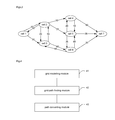
In a solution I, when a record of a cell migration pair <cell 1, cell 2, residing duration> exists in a snapshot, it means that an edge connects a cell 1 and a cell 2; a probability of transfer from the cell 1 to the cell 2 may be: a number of records of transfer from a source cell 1 to a target cell 2/a number of all records of transfer from the source cell 1. The probability of transfer from the cell 1 to the cell 2 may be set as a weight of an edge pointing from the cell 1 to the cell 2. FIG. 2 is a diagram of a directed graph showing a probability of transfer between two cells according to an embodiment.
In a solution II, when a record of a cell migration pair <cell 1, cell 2, residing duration> exists in a snapshot, it means that an edge connects a cell 1 and a cell 2; a duration of transfer from the cell 1 to the cell 2 may be an average residing duration over all records <cell 1, cell 2, residing duration>. The duration of transfer from the cell 1 to the cell 2 may be set as a weight of an edge pointing from the cell 1 to the cell 2, and FIG. 3 is a diagram of a directed graph showing a duration needed for transfer between two cells according to an embodiment.
The solution II may be improved by using a higher-order contextual model such as a second-order model. In this case, it is necessary to extract and record a pair <second last cell ID, last cell ID, present cell ID, residing duration> to perform modelling and find a solution using the second-order mode. Implementation using a still higher-order model is possible, so on and so forth.
If trajectories in a present snapshot are too few to model the inter-cell adjacency with accuracy, a historical snapshot may be used together with the present snapshot for constructing the directed graph. However in this case, it has to be ensured that a context state of the historical snapshot matches a present state. Thus, a recent historical snapshot with index characteristics similar to present index characteristics has to be selected.
In step 102, a departure point and a destination point in the actual geographic space are mapped respectively to a departure grid and a destination grid; and a grid-level path from the departure grid to the destination grid is determined according to the modelled inter-grid adjacency.
The navigation system may receive the departure point and the destination point input by a user, map the departure point to the departure grid and the destination point to the destination grid according to a location mapping relation, and determine a grid-level path from the departure grid to the destination grid according to the inter-grid adjacency modelled in step 101.
When the cells of the cellular network may be set as the grids, a base station and/or cell closest to the departure/destination point may be selected as a departure base station/destination cell according to longitudes and latitudes of the departure point, the destination point, and the cells.
The directed graph showing a probability of transfer between two cells may be established according to the solution I. An optimal path from a departure cell to a destination cell may be a most probable path among all paths starting from a node corresponding to the departure cell and ending at a node corresponding to the destination cell. As shown in FIG. 2, an optimal path from a departure cell 1 to a destination cell 7 may be: cell 1→cell 2→cell 4→cell 7 with a generated path probability of 0.7*0.3*0.9=0.189, which is greater than that of any other path, such as a generated probability of a path cell 1→cell 2→cell 5→cell 6→cell 7 0.7*0.2*0.4*0.1=0.0056. The weight of an edge in the directed graph showing a probability of transfer may be modified as −log(original edge weight). Accordingly, optimal path computation may be converted into solving a standard problem of search for a shortest path.
The directed graph showing a duration needed for transfer between two cells may be established according to the solution II. As shown in FIG. 3, solving an optimal path from a departure cell to a destination cell may be converted into searching the directed graph for a shortest path. As shown in FIG. 3, an optimal path from a departure cell 1 to a destination cell 7 may be: cell 1→cell 3→cell 6→cell 7, with a transfer duration of 30+60+20=110, which is less than that of any other path, such as a transfer duration 50+25+36=111 of a path cell 1→cell 2→cell 5→cell 7.
In step 103, the grid-level path is converted into an actual route from the departure point to the destination point in the actual geographic space.
The navigation system may map the grid-level path computed in step 102 onto a GIS map and/or a satellite map to obtain the actual route from the departure point to the destination point.
When the cells of the cellular network may be set as the grids, a cell-level path may be mapped onto a GIS map and be converted into an actual route as follows. The cell-level path may be converted into a polyline in two-dimensional space according to longitudes and latitudes of cells and/or base stations in the cell-level path. The polyline may be smoothed using least squares to obtain a smoothed curve. The curve may be buffered or padded with a distance of 500 meters to obtain an area. All roads in the GIS map passing through or contained in the area may be selected. A route from the departure point to the destination point may be computed using a dynamic planning algorithm and a subset of the map.
In an embodiment, the cells of the cellular network may be set as the grids. A cell-level path may be mapped onto a satellite map and be converted into an actual route as follows. The satellite map displaying the cell-level path may be delivered to a user. The user may select a route as instructed by the path according to an actual road condition reflected by the satellite map. In this way, a user may be provided with a road option unavailable in a GIS map, avoiding a problem of GIS map information lagging behind the actual road condition, as generally a newly-built road may not be updated to and displayed in the GIS map in at least three months.
With the route planning method for a navigation system according to the embodiments, route planning may be performed in two stages. First, an actual geographic space is divided into grids using cells of a cellular network. Then, trajectories of mobile stations may be extracted using records of inter-cell handovers of the mobile stations acquired from a mobile operator, such that information on trajectories of multiple real mobile stations may be sensed in real time. Path planning may be performed in a cell space of the cellular network, and then route matching may be performed based on a GIS map or a satellite map, which may lower dependence on the accuracy and timeliness of the GIS map, increasing real-time performance, accuracy, and effectiveness of a route planning result, as well as facilitating detecting an error in the GIS map, thereby providing an optimal path tolerant to a map fault. The method herein is based on a mobile communication network, thereby requiring but a low cost of deployment, leading to wide applicability.
According to an embodiment herein, a non-transitory computer-readable storage medium stores therein computer executable instructions for executing aforementioned route planning method for a navigation system herein.
FIG. 4 is a diagram of a structure of a route planning device for a navigation system according to an embodiment herein. As shown in FIG. 4, the route planning device includes a grid modelling module 41, a grid path finding module 42, and a path converting module 43.
The grid modelling module 41 is configured for: dividing an actual geographic space into grids, the grids being cells of a cellular network; acquiring a handover record of inter-cell handovers of mobile stations; and modelling an inter-cell adjacency according to the handover record.
The grid path finding module 42 is configured for: mapping a departure point and a destination point in the actual geographic space respectively to a departure grid and a destination grid; and determining, according to the modelled inter-cell adjacency, a grid-level path from the departure grid to the destination grid.
The path converting module 43 is configured for: converting the grid-level path into an actual route from the departure point to the destination point in the actual geographic space.
The grids may be the cells of the cellular network. Accordingly, the grid modelling module 41 in the route planning device may be further configured for: filtering the handover record according to a pre-set filtering solution.
The grid modelling module 41 may include:
a trajectory extracting sub-module configured for: extracting trajectories of the mobile stations according to the handover record;
a snapshot managing sub-module configured for: setting a set of all the trajectories within a period of time as a snapshot; and
a modelling sub-module configured for: modelling the inter-cell adjacency within the period of time according to the snapshot.
The modelling sub-module may be further configured for:
establishing, according to the snapshot, a weighted directed graph, with base stations of all the cells as vertices, inter-cell adjacencies as edges, and with an inter-cell adjacency index as a weight of an edge.
The inter-cell adjacency index may be a probability of transfer between two cells, or a duration needed for transfer between two cells.
The path converting module 43 may include:
a GIS map matching sub-module configured for: converting the grid-level path into an actual route from the departure point to the destination point in a GIS map; and/or
a satellite map matching sub-module configured for: converting the grid-level path into an actual route from the departure point to the destination point in a satellite map.
In a practical application, all the modules and the units may be implemented by a Central Processing Unit (CPU), a Micro Processing Unit (MPU), a Digital Signal Processor (DSP), or a Field-Programmable Gate Array (FPGA) located in the navigation system.
The device shown in FIG. 4 solves a problem in a way similar to the method. Refer to implementation of the method as described for that of the device herein, which will not be repeated.
Those skilled in the art will know that an embodiment herein may be provided as a method, system, or computer program product. Therefore, an embodiment herein may take on a form of hardware, software, or a combination thereof. In addition, an embodiment herein may take on a form of a computer program product implemented on one or more computer available storage media (including but not limited to, magnetic disk memory, optic memory, and the like) containing computer available program codes.
The present disclosure is illustrated with reference to flowcharts and/or block diagrams of the method, device (system) and computer-program product according to embodiments described herein. Note that each flow in the flowcharts and/or each block in the block diagrams as well as combination of flows in the flowcharts and/or blocks in the block diagrams may be implemented by instructions of a computer program. Such instructions may be offered in a processor of a general-purpose computer, a dedicated computer, an embedded processor or other programmable data processing devices to generate a machine, such that a device with a function specified in one or more flows of the flowcharts and/or one or more blocks in the block diagrams is produced by instructions executed by a processor of a computer or other programmable data processing devices.
These computer-program instructions may also be stored in a non-transitory computer-readable memory capable of guiding a computer or another programmable data processing device to work in a given way, such that the instructions stored in the computer-readable memory generate a manufactured good including an instruction device for implementing a function specified in one or more flows of the flowcharts and/or one or more blocks in the block diagrams.
These computer-program instructions may also be loaded in a computer or other programmable data processing devices, which thus executes a series of operations thereon to generate computer-implemented processing, such that the instructions executed on the computer or other programmable data processing devices provide the steps for implementing the function specified in one or more flows of the flowcharts or one or more blocks in the block diagrams.
What described are merely embodiments of the present disclosure, and are not intended to limit the scope of the present disclosure.
INDUSTRIAL APPLICABILITY
With a route planning method and device for a navigation system, as well as a non-transitory computer-readable storage medium according to embodiments herein, route planning may be performed in two stages. First, an actual geographic space is divided into grids using cells of a cellular network. Then, trajectories of mobile stations may be extracted using records of inter-cell handovers of the mobile stations acquired from a mobile operator, such that information on trajectories of multiple real mobile stations may be sensed in real time. Path planning may be performed in a cell space of the cellular network, and then route matching may be performed based on a GIS map or a satellite map, which may lower dependence on the accuracy and timeliness of the GIS map, increasing real-time performance, accuracy, and effectiveness of a route planning result, as well as facilitating detecting an error in the GIS map, thereby providing an optimal path tolerant to a map fault. The method herein is based on a mobile communication network, thereby requiring but a low cost of deployment, leading to wide applicability.

Claims (6)

The invention claimed is:
1. A route planning method for a navigation system, comprising:
acquiring a handover record of inter-cell handovers of mobile stations; and modelling an inter-cell adjacency according to the handover record, wherein an actual geographic space is divided into a grid of cells of a cellular network;
mapping a departure point and a destination point in the actual geographic space respectively to a departure cell and a destination cell; and determining, according to the modelled inter-cell adjacency, a grid-level path from the departure cell to the destination cell; and
converting the grid-level path into an actual route from the departure point to the destination point in the actual geographic space,
wherein the acquiring a handover record of inter-cell handovers of mobile stations comprises:
reading a file recording inter-cell handovers of mobile stations stored in a dedicated File Transfer Protocol (FTP) server by a signalling collecting platform of a mobile operator, and acquiring handover records from the file,
wherein the method further comprises, before the modelling an inter-cell adjacency according to the handover record:
filtering the handover record by at least one of:
deleting a record related to a number of a mobile station with no mobility;
retaining only records related to specific mobile station numbers; or
deleting a handover record when a cell identifier in the handover record is not one of cell identifiers loaded in memory,
wherein the modelling an inter-cell adjacency according to the handover record comprises:
extracting trajectories of the mobile stations according to the handover record;
setting a set of all the trajectories within a period of time as a snapshot; and
modelling the inter-cell adjacency within the period of time according to the snapshot by:
establishing, according to the snapshot, a weighted directed graph, with base stations of all the cells as vertices, inter-cell adjacencies as edges, and with an inter-cell adjacency index as a weight of an edge,
wherein the inter-cell adjacency index is a probability of transfer between two cells, and
wherein the probability is a number of records of transfer from a source cell to a target cell divided by a number of all records of transfer from the source cell.
2. The method according to claim 1, wherein the converting the grid-level path into an actual route from the departure point to the destination point in the actual geographic space comprises:
converting the grid-level path into an actual route from the departure point to the destination point in a Geographic Information System (GIS) map; and/or
converting the grid-level path into an actual route from the departure point to the destination point in a satellite map.
3. A route planning device for a navigation system, comprising:
a processor; and
memory storing instructions executable by the processor, wherein the processor
is configured for performing a route planning method for a navigation system, the method comprising:
acquiring a handover record of inter-cell handovers of mobile stations; and modelling an inter-cell adjacency according to the handover record, wherein an actual geographic space is divided into a grid of cells of a cellular network;
mapping a departure point and a destination point in the actual geographic space respectively to a departure cell and a destination cell; and determining, according to the modelled inter-cell adjacency, a grid-level path from the departure cell to the destination cell; and
converting the grid-level path into an actual route from the departure point to the destination point in the actual geographic space,
wherein the acquiring a handover record of inter-cell handovers of mobile stations comprises:
reading a file recording inter-cell handovers of mobile stations stored in a dedicated File Transfer Protocol (FTP) server by a signalling collecting platform of a mobile operator, and acquiring handover records from the file,
wherein the method further comprises, before the modelling an inter-cell adjacency according to the handover record:
filtering the handover record by at least one of:
deleting a record related to a number of a mobile station with no mobility;
retaining only records related to specific mobile station numbers; or
deleting a handover record when a cell identifier in the handover record is not one of cell identifiers loaded in memory,
wherein the modelling an inter-cell adjacency according to the handover record comprises:
extracting trajectories of the mobile stations according to the handover record;
setting a set of all the trajectories within a period of time as a snapshot; and
modelling the inter-cell adjacency within the period of time according to the snapshot by:
establishing, according to the snapshot, a weighted directed graph, with base stations of all the cells as vertices, inter-cell adjacencies as edges, and with an inter-cell adjacency index as a weight of an edge,
wherein the inter-cell adjacency index is a probability of transfer between two cells, and
wherein the probability is a number of records of transfer from a source cell to a target cell divided by a number of all records of transfer from the source cell.
4. The device according to claim 3, wherein the converting the grid-level path into an actual route from the departure point to the destination point in the actual geographic space comprises:
converting the grid-level path into an actual route from the departure point to the destination point in a Geographic Information System (GIS) map; and/or
converting the grid-level path into an actual route from the departure point to the destination point in a satellite map.
5. A non-transitory computer-readable storage medium, storing therein computer executable instructions for executing a route planning method for a navigation system, the method comprising:
acquiring a handover record of inter-cell handovers of mobile stations; and modelling an inter-cell adjacency according to the handover record, wherein an actual geographic space is divided into a grid of cells of a cellular network;
mapping a departure point and a destination point in the actual geographic space respectively to a departure cell and a destination cell; and determining, according to the modelled inter-cell adjacency, a grid-level path from the departure cell to the destination cell; and
converting the grid-level path into an actual route from the departure point to the destination point in the actual geographic space,
wherein the acquiring a handover record of inter-cell handovers of mobile stations comprises:
reading a file recording inter-cell handovers of mobile stations stored in a dedicated File Transfer Protocol (FTP) server by a signalling collecting platform of a mobile operator, and acquiring handover records from the file,
wherein the method further comprises, before the modelling an inter-cell adjacency according to the handover record:
filtering the handover record by at least one of:
deleting a record related to a number of a mobile station with no mobility;
retaining only records related to specific mobile station numbers; or
deleting a handover record when a cell identifier in the handover record is not one of cell identifiers loaded in memory,
wherein the modelling an inter-cell adjacency according to the handover record comprises:
extracting trajectories of the mobile stations according to the handover record;
setting a set of all the trajectories within a period of time as a snapshot; and
modelling the inter-cell adjacency within the period of time according to the snapshot by:
establishing, according to the snapshot, a weighted directed graph, with base stations of all the cells as vertices, inter-cell adjacencies as edges, and with an inter-cell adjacency index as a weight of an edge,
wherein the inter-cell adjacency index is a probability of transfer between two cells, and
wherein the probability is a number of records of transfer from a source cell to a target cell divided by a number of all records of transfer from the source cell.
6. The non-transitory computer-readable storage medium according to claim 5, wherein the converting the grid-level path into an actual route from the departure point to the destination point in the actual geographic space comprises:
converting the grid-level path into an actual route from the departure point to the destination point in a Geographic Information System (GIS) map; and/or
converting the grid-level path into an actual route from the departure point to the destination point in a satellite map.
US15/112,512 2014-08-22 2015-01-19 Route planning method and device for navigation system and storage medium Active 2035-05-10 US10119829B2 (en)

Applications Claiming Priority (4)

Application Number Priority Date Filing Date Title
CN201410419871 2014-08-22
CN201410419871.7 2014-08-22
CN201410419871.7A CN105466435B (en) 2014-08-22 2014-08-22 Route planning method and device of navigation system
PCT/CN2015/071028 WO2015131681A1 (en) 2014-08-22 2015-01-19 Route planning method and device for navigation system and storage medium

Publications (2)

Publication Number Publication Date
US20160334237A1 US20160334237A1 (en) 2016-11-17
US10119829B2 true US10119829B2 (en) 2018-11-06

Family

ID=54054533

Family Applications (1)

Application Number Title Priority Date Filing Date
US15/112,512 Active 2035-05-10 US10119829B2 (en) 2014-08-22 2015-01-19 Route planning method and device for navigation system and storage medium

Country Status (6)

Country Link
US (1) US10119829B2 (en)
EP (1) EP3086302A4 (en)
JP (1) JP2017524902A (en)
KR (1) KR101909365B1 (en)
CN (1) CN105466435B (en)
WO (1) WO2015131681A1 (en)

Cited By (2)

* Cited by examiner, † Cited by third party
Publication number Priority date Publication date Assignee Title
US20230099718A1 (en) * 2021-09-30 2023-03-30 Toyota Jidosha Kabushiki Kaisha Information processing device, information processing system, and storage medium
US20240118097A1 (en) * 2022-09-30 2024-04-11 Orange Determination of an itinerary as a function of the quality of service of a communication network

Families Citing this family (15)

* Cited by examiner, † Cited by third party
Publication number Priority date Publication date Assignee Title
US10169400B2 (en) * 2015-06-19 2019-01-01 International Business Machines Corporation Geographic space management
CN107133339A (en) * 2017-05-17 2017-09-05 北京趣拿软件科技有限公司 Circuit query method and apparatus and storage medium, processor
CN110650507B (en) * 2018-06-27 2022-03-08 中兴通讯股份有限公司 Cell switching judgment method, device and equipment and edge computing node
CN109299822A (en) * 2018-09-21 2019-02-01 中国联合网络通信集团有限公司 Vehicle scheduling method, device, system and storage medium
CN109800957B (en) * 2018-12-24 2023-02-03 武汉思路富邦工程咨询有限公司 Method for quickly generating planning route of BIM engineering project
CN110109134B (en) * 2019-05-05 2022-11-25 桂林电子科技大学 A Method of Maximum Likelihood Estimation for Polyline Extraction Based on 2D LiDAR Ranging
CN110706356B (en) * 2019-09-19 2023-06-16 阿波罗智联(北京)科技有限公司 Path drawing method, path drawing device, electronic equipment and storage medium
CN115396964A (en) * 2019-12-11 2022-11-25 华为技术有限公司 Network switching method and electronic equipment
US11882507B2 (en) * 2020-01-08 2024-01-23 Veniam, Inc. Methods and systems for in-vehicle data-driven connectivity optimization in a network of moving things
CN111641984B (en) * 2020-05-28 2022-11-04 哲库科技(北京)有限公司 Cell selection method, terminal and storage medium
CN111884939B (en) * 2020-08-31 2022-04-08 广州文远知行科技有限公司 Data transmission method, device, mobile carrier and storage medium
KR102671170B1 (en) * 2020-09-18 2024-06-03 한국전력공사 Apparatus for generating line with distributed generation and method thereof
CN112101676B (en) * 2020-09-23 2022-02-15 腾讯科技(深圳)有限公司 Riding path planning method and device, computer equipment and storage medium
CN113190769B (en) * 2021-05-08 2023-09-19 北京百度网讯科技有限公司 Communication characteristic data determining method, device, electronic equipment and storage medium
CN117915417B (en) * 2024-03-19 2024-06-18 深圳心派科技有限公司 Base station switching planning method, device and system

Citations (28)

* Cited by examiner, † Cited by third party
Publication number Priority date Publication date Assignee Title
US5295180A (en) * 1992-04-08 1994-03-15 U S West Newvector Group, Inc. Cellular telephone zone system
US20030008619A1 (en) * 2001-07-03 2003-01-09 Werner Raymond J. Location-based information service for identifying areas with degraded radio signal strength
US6853910B1 (en) 2003-08-11 2005-02-08 General Motors Corporation Vehicle tracking telematics system
US20050156715A1 (en) * 2004-01-16 2005-07-21 Jie Zou Method and system for interfacing with mobile telemetry devices
US20060183487A1 (en) * 2005-02-15 2006-08-17 @Road, Inc. Method for locating coverage gaps in wireless communication services
US20070211676A1 (en) * 2006-03-13 2007-09-13 Ranjan Sharma Providing information on wireless service coverage along routes being considered for a journey
US7373152B2 (en) * 2002-11-13 2008-05-13 General Motors Corporation Radio signal strength mapping through a telematics system
US20080183380A1 (en) * 2007-01-10 2008-07-31 Adrian Blackwood Navigation device and method for determining network coverage
CN101272590A (en) 2007-03-21 2008-09-24 展讯通信(上海)有限公司 Arrival time-receiving strength associated wireless locating method and device
US20080242315A1 (en) 2007-03-27 2008-10-02 Gm Global Technology Operations, Inc. Traffic data collection utilizing a cellular communication network and probe units
JP2008539427A (en) 2005-04-25 2008-11-13 ザ・ボーイング・カンパニー Advanced land transport management
CN101400104A (en) 2008-10-24 2009-04-01 中国移动通信集团山东有限公司 Method and system for implementing mobile positioning service
CN101794516A (en) 2009-12-25 2010-08-04 北京工业大学 Mobile phone information based section speed calculation method
US20110081922A1 (en) 2009-10-01 2011-04-07 Nokia Corporation Method and apparatus for providing location based services using connectivity graphs based on cell broadcast information
US20110144899A1 (en) * 2009-12-14 2011-06-16 Emily Soelberg Systems and Methods for Providing Geographical Information to a Mobile Communications Device
US20110172906A1 (en) * 2010-01-14 2011-07-14 Qualcomm Incorporated Scalable Routing For Mobile Station Navigation With Location Context Identifier
US20120115505A1 (en) 2010-11-09 2012-05-10 Motoharu Miyake System and method for population tracking, counting, and movement estimation using mobile operational data and/or geographic information in mobile network
CN102521973A (en) 2011-12-28 2012-06-27 昆明理工大学 Road matching method for mobile phone switching positioning
US20130325317A1 (en) * 2012-06-05 2013-12-05 Apple Inc. Smart loading of map tiles
US20140278070A1 (en) * 2013-03-15 2014-09-18 Apple Inc. Warning for Frequently Traveled Trips Based on Traffic
US20140278074A1 (en) * 2013-03-14 2014-09-18 Qualcomm Incorporated Navigation Using Crowdsourcing Data
US20150019124A1 (en) * 2007-08-06 2015-01-15 Amrit Bandyopadhyay System and method for locating, tracking, and/or monitoring the status of personnel and/or assets both indoors and outdoors
US9002634B1 (en) * 2013-12-12 2015-04-07 Verizon Patent And Licensing Inc. Navigation service in support of mobile communication sessions
US20150160018A1 (en) * 2013-12-06 2015-06-11 Michael Ameling Sensor-less indoor navigation assistance
US20160044129A1 (en) * 2014-08-11 2016-02-11 Harman International Industries, Incorporated Adaptive bandwidth consumption optimization for wireless data connections
US9565625B1 (en) * 2015-09-09 2017-02-07 Ford Global Technologies, Llc Multiprotocol vehicle communications
US9740205B2 (en) * 2015-12-08 2017-08-22 Uber Technologies, Inc. Autonomous vehicle communication configuration system
US9762339B2 (en) * 2014-02-11 2017-09-12 Panasonic Automotive Systems Company of North America, Division of Panasonic Corporation of North America Terrestrial radio switch manager for smart cellular streaming

Patent Citations (32)

* Cited by examiner, † Cited by third party
Publication number Priority date Publication date Assignee Title
US5295180A (en) * 1992-04-08 1994-03-15 U S West Newvector Group, Inc. Cellular telephone zone system
US20030008619A1 (en) * 2001-07-03 2003-01-09 Werner Raymond J. Location-based information service for identifying areas with degraded radio signal strength
US7373152B2 (en) * 2002-11-13 2008-05-13 General Motors Corporation Radio signal strength mapping through a telematics system
US6853910B1 (en) 2003-08-11 2005-02-08 General Motors Corporation Vehicle tracking telematics system
US20050156715A1 (en) * 2004-01-16 2005-07-21 Jie Zou Method and system for interfacing with mobile telemetry devices
US20060183487A1 (en) * 2005-02-15 2006-08-17 @Road, Inc. Method for locating coverage gaps in wireless communication services
JP2008539427A (en) 2005-04-25 2008-11-13 ザ・ボーイング・カンパニー Advanced land transport management
US20070211676A1 (en) * 2006-03-13 2007-09-13 Ranjan Sharma Providing information on wireless service coverage along routes being considered for a journey
US20080183380A1 (en) * 2007-01-10 2008-07-31 Adrian Blackwood Navigation device and method for determining network coverage
CN101272590A (en) 2007-03-21 2008-09-24 展讯通信(上海)有限公司 Arrival time-receiving strength associated wireless locating method and device
US20080242315A1 (en) 2007-03-27 2008-10-02 Gm Global Technology Operations, Inc. Traffic data collection utilizing a cellular communication network and probe units
CN101647047A (en) 2007-03-27 2010-02-10 通用汽车环球科技运作公司 Traffic data collection utilizing a cellular communication network and probe units
US20150019124A1 (en) * 2007-08-06 2015-01-15 Amrit Bandyopadhyay System and method for locating, tracking, and/or monitoring the status of personnel and/or assets both indoors and outdoors
CN101400104A (en) 2008-10-24 2009-04-01 中国移动通信集团山东有限公司 Method and system for implementing mobile positioning service
US20110081922A1 (en) 2009-10-01 2011-04-07 Nokia Corporation Method and apparatus for providing location based services using connectivity graphs based on cell broadcast information
US20120329482A1 (en) 2009-10-01 2012-12-27 Nokia Corporation Method and apparatus for providing location based services using connectivity graphs based on cell broadcast information
US20110144899A1 (en) * 2009-12-14 2011-06-16 Emily Soelberg Systems and Methods for Providing Geographical Information to a Mobile Communications Device
CN101794516A (en) 2009-12-25 2010-08-04 北京工业大学 Mobile phone information based section speed calculation method
US20110172906A1 (en) * 2010-01-14 2011-07-14 Qualcomm Incorporated Scalable Routing For Mobile Station Navigation With Location Context Identifier
US20120115505A1 (en) 2010-11-09 2012-05-10 Motoharu Miyake System and method for population tracking, counting, and movement estimation using mobile operational data and/or geographic information in mobile network
US20120115476A1 (en) 2010-11-09 2012-05-10 Hyung Sik Shin System and method for population tracking, counting, and movement estimation using mobile operational data and/or geographic information in mobile network
US20120115475A1 (en) 2010-11-09 2012-05-10 Motoharu Miyake System and method for population tracking, counting, and movement estimation using mobile operational data and/or geographic information in mobile network
CN102521973A (en) 2011-12-28 2012-06-27 昆明理工大学 Road matching method for mobile phone switching positioning
US20130325317A1 (en) * 2012-06-05 2013-12-05 Apple Inc. Smart loading of map tiles
US20140278074A1 (en) * 2013-03-14 2014-09-18 Qualcomm Incorporated Navigation Using Crowdsourcing Data
US20140278070A1 (en) * 2013-03-15 2014-09-18 Apple Inc. Warning for Frequently Traveled Trips Based on Traffic
US20150160018A1 (en) * 2013-12-06 2015-06-11 Michael Ameling Sensor-less indoor navigation assistance
US9002634B1 (en) * 2013-12-12 2015-04-07 Verizon Patent And Licensing Inc. Navigation service in support of mobile communication sessions
US9762339B2 (en) * 2014-02-11 2017-09-12 Panasonic Automotive Systems Company of North America, Division of Panasonic Corporation of North America Terrestrial radio switch manager for smart cellular streaming
US20160044129A1 (en) * 2014-08-11 2016-02-11 Harman International Industries, Incorporated Adaptive bandwidth consumption optimization for wireless data connections
US9565625B1 (en) * 2015-09-09 2017-02-07 Ford Global Technologies, Llc Multiprotocol vehicle communications
US9740205B2 (en) * 2015-12-08 2017-08-22 Uber Technologies, Inc. Autonomous vehicle communication configuration system

Non-Patent Citations (3)

* Cited by examiner, † Cited by third party
Title
English Translation of the Written Opinion of the International Search Authority in international application No. PCT/CN2015/071028, dated May 22, 2015, 7 pgs.
International Search Report in international application No. PCT/CN2015/071028, dated May 22, 2015, 5 pgs.
Supplementary European Search Report in European application No. 15758250.3, dated Jul. 26, 2017, 8 pgs.

Cited By (2)

* Cited by examiner, † Cited by third party
Publication number Priority date Publication date Assignee Title
US20230099718A1 (en) * 2021-09-30 2023-03-30 Toyota Jidosha Kabushiki Kaisha Information processing device, information processing system, and storage medium
US20240118097A1 (en) * 2022-09-30 2024-04-11 Orange Determination of an itinerary as a function of the quality of service of a communication network

Also Published As

Publication number Publication date
JP2017524902A (en) 2017-08-31
CN105466435A (en) 2016-04-06
EP3086302A1 (en) 2016-10-26
KR101909365B1 (en) 2018-10-17
WO2015131681A1 (en) 2015-09-11
EP3086302A4 (en) 2017-08-23
CN105466435B (en) 2020-07-10
KR20160143741A (en) 2016-12-14
US20160334237A1 (en) 2016-11-17

Similar Documents

Publication Publication Date Title
US10119829B2 (en) Route planning method and device for navigation system and storage medium
CN109996186B (en) A network coverage problem identification method and device, and readable storage medium
US10955586B2 (en) Weather forecasting system and methods
US8577389B2 (en) Filtering and clustering crowd-sourced data for determining beacon positions
US8359156B2 (en) Map generation system and map generation method by using GPS tracks
CN102147260B (en) Electronic map matching method and device
US9125019B1 (en) Positioning arrangement, method, mobile device and computer program
CN111488414B (en) Road task matching method, device and equipment
CN107871400B (en) Road network information updating method and device
RU2607417C2 (en) Method and system for navigation using associated geographical regions
CN111787488B (en) User positioning method and system
CN105468631A (en) Point-of-interest query method and apparatus
US10657806B1 (en) Transformation of point of interest geometries to lists of route segments in mobile communication device traffic analysis
CN103491625A (en) Method and system for locating wireless mobile terminal
US9651389B2 (en) Generation of location area boundaries
CN113518328A (en) Identification method, positioning method, device and equipment of network access equipment
CN116698075B (en) Road network data processing method and device, electronic equipment and storage medium
KR20240046793A (en) Positioning method and apparatus, and device and storage medium
CN115604814A (en) Outdoor equipment positioning method, device, terminal equipment and medium
TWI418836B (en) Wireless network signal collection and verification system
CN113593244A (en) Flow determination method and device, storage medium and electronic device
CN115687546A (en) Map data processing method and device
CN113254565B (en) Area identification method, apparatus, computer equipment, and computer-readable storage medium
CN111473793A (en) Method, device and equipment for determining road traffic state
CN116819577A (en) Road identification method, device, electronic equipment and storage medium

Legal Events

Date Code Title Description
AS Assignment

Owner name: ZTE CORPORATION, CHINA

Free format text: ASSIGNMENT OF ASSIGNORS INTEREST;ASSIGNOR:WANG, LIXUE;REEL/FRAME:040382/0751

Effective date: 20160531

AS Assignment

Owner name: XI'AN ZHONGXING NEW SOFTWARE CO.LTD., CHINA

Free format text: ASSIGNMENT OF ASSIGNORS INTEREST;ASSIGNOR:ZTE CORPORATION;REEL/FRAME:046609/0541

Effective date: 20180808

STCF Information on status: patent grant

Free format text: PATENTED CASE

MAFP Maintenance fee payment

Free format text: PAYMENT OF MAINTENANCE FEE, 4TH YEAR, LARGE ENTITY (ORIGINAL EVENT CODE: M1551); ENTITY STATUS OF PATENT OWNER: LARGE ENTITY

Year of fee payment: 4