KR20170091680A - Method and apparatus for providing point of interest information - Google Patents
Method and apparatus for providing point of interest information Download PDFInfo
- Publication number
- KR20170091680A KR20170091680A KR1020177017847A KR20177017847A KR20170091680A KR 20170091680 A KR20170091680 A KR 20170091680A KR 1020177017847 A KR1020177017847 A KR 1020177017847A KR 20177017847 A KR20177017847 A KR 20177017847A KR 20170091680 A KR20170091680 A KR 20170091680A
- Authority
- KR
- South Korea
- Prior art keywords
- poi
- map data
- map
- sed
- navigation device
- Prior art date
Links
Images


Classifications
-
- G—PHYSICS
- G01—MEASURING; TESTING
- G01C—MEASURING DISTANCES, LEVELS OR BEARINGS; SURVEYING; NAVIGATION; GYROSCOPIC INSTRUMENTS; PHOTOGRAMMETRY OR VIDEOGRAMMETRY
- G01C21/00—Navigation; Navigational instruments not provided for in groups G01C1/00 - G01C19/00
- G01C21/26—Navigation; Navigational instruments not provided for in groups G01C1/00 - G01C19/00 specially adapted for navigation in a road network
- G01C21/34—Route searching; Route guidance
- G01C21/36—Input/output arrangements for on-board computers
- G01C21/3679—Retrieval, searching and output of POI information, e.g. hotels, restaurants, shops, filling stations, parking facilities
- G01C21/3682—Retrieval, searching and output of POI information, e.g. hotels, restaurants, shops, filling stations, parking facilities output of POI information on a road map
-
- G—PHYSICS
- G01—MEASURING; TESTING
- G01C—MEASURING DISTANCES, LEVELS OR BEARINGS; SURVEYING; NAVIGATION; GYROSCOPIC INSTRUMENTS; PHOTOGRAMMETRY OR VIDEOGRAMMETRY
- G01C21/00—Navigation; Navigational instruments not provided for in groups G01C1/00 - G01C19/00
- G01C21/26—Navigation; Navigational instruments not provided for in groups G01C1/00 - G01C19/00 specially adapted for navigation in a road network
- G01C21/34—Route searching; Route guidance
- G01C21/36—Input/output arrangements for on-board computers
- G01C21/3697—Output of additional, non-guidance related information, e.g. low fuel level
-
- G—PHYSICS
- G01—MEASURING; TESTING
- G01C—MEASURING DISTANCES, LEVELS OR BEARINGS; SURVEYING; NAVIGATION; GYROSCOPIC INSTRUMENTS; PHOTOGRAMMETRY OR VIDEOGRAMMETRY
- G01C21/00—Navigation; Navigational instruments not provided for in groups G01C1/00 - G01C19/00
- G01C21/26—Navigation; Navigational instruments not provided for in groups G01C1/00 - G01C19/00 specially adapted for navigation in a road network
- G01C21/28—Navigation; Navigational instruments not provided for in groups G01C1/00 - G01C19/00 specially adapted for navigation in a road network with correlation of data from several navigational instruments
- G01C21/30—Map- or contour-matching
- G01C21/32—Structuring or formatting of map data
-
- G—PHYSICS
- G01—MEASURING; TESTING
- G01C—MEASURING DISTANCES, LEVELS OR BEARINGS; SURVEYING; NAVIGATION; GYROSCOPIC INSTRUMENTS; PHOTOGRAMMETRY OR VIDEOGRAMMETRY
- G01C21/00—Navigation; Navigational instruments not provided for in groups G01C1/00 - G01C19/00
- G01C21/26—Navigation; Navigational instruments not provided for in groups G01C1/00 - G01C19/00 specially adapted for navigation in a road network
- G01C21/34—Route searching; Route guidance
- G01C21/3453—Special cost functions, i.e. other than distance or default speed limit of road segments
- G01C21/3492—Special cost functions, i.e. other than distance or default speed limit of road segments employing speed data or traffic data, e.g. real-time or historical
-
- G—PHYSICS
- G01—MEASURING; TESTING
- G01C—MEASURING DISTANCES, LEVELS OR BEARINGS; SURVEYING; NAVIGATION; GYROSCOPIC INSTRUMENTS; PHOTOGRAMMETRY OR VIDEOGRAMMETRY
- G01C21/00—Navigation; Navigational instruments not provided for in groups G01C1/00 - G01C19/00
- G01C21/26—Navigation; Navigational instruments not provided for in groups G01C1/00 - G01C19/00 specially adapted for navigation in a road network
- G01C21/34—Route searching; Route guidance
- G01C21/36—Input/output arrangements for on-board computers
- G01C21/3679—Retrieval, searching and output of POI information, e.g. hotels, restaurants, shops, filling stations, parking facilities
-
- G—PHYSICS
- G01—MEASURING; TESTING
- G01C—MEASURING DISTANCES, LEVELS OR BEARINGS; SURVEYING; NAVIGATION; GYROSCOPIC INSTRUMENTS; PHOTOGRAMMETRY OR VIDEOGRAMMETRY
- G01C21/00—Navigation; Navigational instruments not provided for in groups G01C1/00 - G01C19/00
- G01C21/26—Navigation; Navigational instruments not provided for in groups G01C1/00 - G01C19/00 specially adapted for navigation in a road network
- G01C21/34—Route searching; Route guidance
- G01C21/36—Input/output arrangements for on-board computers
- G01C21/3691—Retrieval, searching and output of information related to real-time traffic, weather, or environmental conditions
-
- G—PHYSICS
- G01—MEASURING; TESTING
- G01C—MEASURING DISTANCES, LEVELS OR BEARINGS; SURVEYING; NAVIGATION; GYROSCOPIC INSTRUMENTS; PHOTOGRAMMETRY OR VIDEOGRAMMETRY
- G01C21/00—Navigation; Navigational instruments not provided for in groups G01C1/00 - G01C19/00
- G01C21/38—Electronic maps specially adapted for navigation; Updating thereof
- G01C21/3804—Creation or updating of map data
- G01C21/3807—Creation or updating of map data characterised by the type of data
- G01C21/3811—Point data, e.g. Point of Interest [POI]
-
- G—PHYSICS
- G01—MEASURING; TESTING
- G01C—MEASURING DISTANCES, LEVELS OR BEARINGS; SURVEYING; NAVIGATION; GYROSCOPIC INSTRUMENTS; PHOTOGRAMMETRY OR VIDEOGRAMMETRY
- G01C21/00—Navigation; Navigational instruments not provided for in groups G01C1/00 - G01C19/00
- G01C21/38—Electronic maps specially adapted for navigation; Updating thereof
- G01C21/3885—Transmission of map data to client devices; Reception of map data by client devices
- G01C21/3889—Transmission of selected map data, e.g. depending on route
-
- G—PHYSICS
- G06—COMPUTING; CALCULATING OR COUNTING
- G06F—ELECTRIC DIGITAL DATA PROCESSING
- G06F16/00—Information retrieval; Database structures therefor; File system structures therefor
- G06F16/20—Information retrieval; Database structures therefor; File system structures therefor of structured data, e.g. relational data
- G06F16/29—Geographical information databases
-
- G—PHYSICS
- G08—SIGNALLING
- G08G—TRAFFIC CONTROL SYSTEMS
- G08G1/00—Traffic control systems for road vehicles
- G08G1/09—Arrangements for giving variable traffic instructions
- G08G1/0962—Arrangements for giving variable traffic instructions having an indicator mounted inside the vehicle, e.g. giving voice messages
- G08G1/0967—Systems involving transmission of highway information, e.g. weather, speed limits
- G08G1/096708—Systems involving transmission of highway information, e.g. weather, speed limits where the received information might be used to generate an automatic action on the vehicle control
- G08G1/096716—Systems involving transmission of highway information, e.g. weather, speed limits where the received information might be used to generate an automatic action on the vehicle control where the received information does not generate an automatic action on the vehicle control
-
- H—ELECTRICITY
- H04—ELECTRIC COMMUNICATION TECHNIQUE
- H04W—WIRELESS COMMUNICATION NETWORKS
- H04W4/00—Services specially adapted for wireless communication networks; Facilities therefor
- H04W4/02—Services making use of location information
- H04W4/021—Services related to particular areas, e.g. point of interest [POI] services, venue services or geofences
Abstract
본 발명의 실시예들은 관심 포인트 (POI)와 연관된 데이터를 제공하는 방법을 제공하며, 상기 방법은, POI의 위치를 기반으로 하여 지리적 구역의 디지털 지도 데이터의 일부를 판별하는 단계로, 상기 디지털 지도 데이터는 상기 지리적 구역 내 운행가능 네트워크의 운행가능 요소들을 나타내는 복수의 세그먼트들을 포함하는, 단계 그리고 디지털 지도 데이터의 상기 일부 내 적어도 몇몇의 세그먼트들을 나타내는 상기 POI와 연관된 POI-지도 데이터를 생성하는 단계를 포함한다.Embodiments of the present invention provide a method of providing data associated with a point of interest (POI), the method comprising the steps of determining a portion of digital map data of a geographic area based on a location of a POI, Wherein the data comprises a plurality of segments representative of operable elements of a drivable network within the geographic area, and generating POI-map data associated with the POI representing at least some segments in the portion of digital map data .
Description
본 발명은, 실시예들에서, 관심 포인트 (point of interest (POI))와 연관된 데이터를 제공하는 방법 및 장치에 관한 것이다. 본 발명은, 실시예들에서, POI와 연관된 데이터를 기반으로 하여 관심 포인트와 연관된 정보를 제공하는 방법 및 장치에 또한 관련된다.The present invention relates, in embodiments, to a method and apparatus for providing data associated with a point of interest (POI). The present invention also relates, in embodiments, to a method and apparatus for providing information associated with a point of interest based on data associated with a POI.
GNSS (Global Navigation Satellite Systems) 신호 수신 및 프로세싱 기능성을 포함하는 스마트폰, 휴대용 내비게이션 디바이스 및 통합된 내비게이션 시스템과 같은 모바일 전자 디바이스들은 잘 알려져 있으며 차량-내 또는 다른 차량 내비게이션 시스템으로서 널리 사용된다. 일상적인 말로, 내비게이션 기능성을 가진 알려진 전자 디바이스는 프로세서, 메모리 (휘발성 및 비-휘발성 중 적어도 하나, 그리고 보통은 둘 모두), 그리고 상기 메모리 내에 저장된 디지털 지도 데이터를 포함한다. 상기 프로세서 및 메모리는 협응하여 실행 환경을 제공하며, 이 실행 환경에서 소프트웨어 운영 시스템이 설립될 수 있으며, 그리고 추가적으로 하나 이상의 추가적인 소프트웨어 프로그램들이 제공되어 모바일 디바이스/PND의 기능성이 제어되는 것을 가능하게 하며, 그리고 다양한 다른 기능들을 제공하는 것을 가능하게 하는 것은 흔한 일이다. Mobile electronic devices such as smart phones, portable navigation devices and integrated navigation systems, including Global Navigation Satellite Systems (GNSS) signal reception and processing functionality, are well known and widely used as in-vehicle or other vehicle navigation systems. As a rule of thumb, a known electronic device with navigation functionality includes a processor, memory (at least one of volatile and non-volatile, and usually both), and digital map data stored in the memory. The processor and memory cooperate to provide an execution environment in which a software operating system can be established and additionally one or more additional software programs are provided to enable the functionality of the mobile device / PND to be controlled, It is also common to make it possible to provide a variety of other functions.
그런 디바이스들은 GPS 안테나와 같은 GNSS 안테나를 또한 포함하며, 그 안테나에 의해 위치 데이터를 포함하는 위상-브로드캐스트 신호들이 수신될 수 있으며 그리고 그 후에 프로세싱되어, 디지털 지도와 관련된 디바이스의 현재 위치를 판별하도록 한다. 상기 디바이스는 전자 자이로스코프들 및 가속도계들을 또한 포함할 수 있으며, 그것들은 현재 각 가속도 및 선형 가속도를 결정하기 위해 프로세싱될 수 있다. 상기 결정된 가속도는 그러면 상기 GPS 신호로부터 유도된 위치 정보와 함께 사용되어, 상기 디바이스의 속도 및 상대적 변위를 판별하도록 하며 그래서 그것들이 보통 설치되어 있는 차량의 속도 및 상대적 변위를 판별하도록 한다. 그런 센서들은 대개는 차량-내 내비게이션 시스템들 내에 보통 제공되지만, 상기 모바일 디바이스/PND 그 자체 내에 또한 제공될 수 있을 것이다.Such devices also include a GNSS antenna, such as a GPS antenna, in which the phase-broadcast signals containing position data can be received and then processed to determine the current position of the device associated with the digital map do. The device may also include electronic gyroscopes and accelerometers, which may be processed to determine current angular acceleration and linear acceleration. The determined acceleration is then used in conjunction with the position information derived from the GPS signal to determine the speed and relative displacement of the device so that they can determine the speed and relative displacement of the vehicle in which it is normally installed. Such sensors are usually usually provided in in-vehicle navigation systems, but may also be provided within the mobile device / PND itself.
근래에, 그런 디바이스들은 관심 포인트들 (points of interest (POIs))의 알려진 위치들에 접근하고 있을 때에 운전자들에게 경보를 발하기 위해 시스템들 내에서 또한 사용되며, 그 관심 포인트들은 다음의 것들일 수 있다: 과속 방지 디바이스들 (즉, 속도 함정들 및 과속 방지 카메라들); 스쿨 존들, 사고 다발 지역들, 도로 공사들과 같은 도로 장애 구역들; 및 블랙 아이스, 눈, 범람 및 폭우, 관목 지대 화재 등과 같은 날씨 장애 구역들. 속도 카메라들은 사고 다발 지역들을 나타내기 위해 알려진 위치들에서 교통량을 느리게 하기 위해 종종 제공되며, 그리고 그 자체가 장애 구역들들을 나타낼 수 있으며, 이는 다른 도로 사용자들이 갑자기 그리고 뜻밖에 브레이크를 잡을 수 있기 때문이며, 이것은 운전자들이 과속 방지 디바이스를 볼 때에 그 운전자들에 의한 흔한 반응이다. 과속 방지 디바이스의 존재를 운전자에게 경고하는 디바이스들은 운전자의 안전을 개선시키며, 이는 그것들이 그런 장애 구역들의 위치를 운전자에게 경고하기 때문이다.In the meantime, such devices are also used in systems to alert drivers when they are approaching known locations of points of interest (POIs), the points of interest being Speeding devices (i.e., speed traps and overspeed cameras); Road zones, such as school zones, accidental areas, roadworks; And weather zones such as black ice, snow, flooding and heavy rains, and shrub fire. Speed cameras are often provided to slow down traffic at known locations to indicate areas of accidents, and may themselves represent obstacles, as other road users may suddenly and unexpectedly brak down, This is a common reaction by drivers when drivers see overspeed protection devices. Devices that warn the driver of the presence of overspeed prevention devices improve the safety of the driver because they warn the driver of the location of such obstructions.
그런 시스템들에서, GPS 안테나 및 관심 포인트들 (POIs)의 위치를 포함하는 데이터베이스로의 액세스를 구비한 디바이스는 보통은 차량 내에 제공된다. 그 디바이스는 GPS 신호로부터 유도된 위치 정보를 이용하는 차량이 상기 데이터베이스 내에 저장된 POI의 위치에 접근하고 있을 때에 운전자에게 경고하도록 구성된다. In such systems, a device with access to a database containing the location of the GPS antenna and points of interest (POIs) is usually provided in the vehicle. The device is configured to warn the driver when the vehicle using the location information derived from the GPS signal is approaching the location of the POI stored in the database.
몇몇의 시스템들에서, 상기 디바이스가 내비게이션 디바이스이며 운행가능 네트워크의 디지털 지도 표현, 예를 들면, 도로 네트워크를 포함할 때에, 자신의 위치를 포함하는 POI들에 관한 정보는 보통은 상기 디지털 지도 내에 포함된다. 상기 디지털 지도 (또는 때로는 수학적 그래프로 알려지기도 함)는 자신의 가장 단순한 모습에서, 유효하게는 데이터베이스이며, 그 데이터베이스는 대개는 도로 교차점들을 보통 표시하는 노드들, 그리고 그 교차점들 사이의 도로들을 표시하는 그 노드들 사이의 라인들을 대표하는 데이터를 포함한다. 더욱 상세한 디지털 지도들에서, 라인들은 시작 노드 및 종료 노드에 의해 정의된 세그먼트들로 분할될 수 있다. 이 노드들은 자신들이 최소 3개의 라인들이나 세그먼트들이 교차하는 곳인 도로 교차점을 나타낸다는 점에서 "실제 (real)"일 수 있으며, 또는 이 노드들은 자신들이, 특히 도로의 특별한 확장에 대한 형상 정보 또는 도로를 따라 그 도로의 특성들, 예를 들면, 속도 제한이 변하는 위치를 식별하는 수단을 제공하기 위해서 실제의 노드에 의해 한 말단 또는 양 말단들에서 정의되지 않은 세그먼트들을 위한 앵커들로서 제공된다는 점에서 "인위적 (artificial)"일 수 있다. 비록 디지털 지도가 POI의 지리적인 좌표들, 예를 들면, 경도 및 위도를 또한 종종 포함할 것이지만, 그 POI들의 위치는 보통은 디지털 지도의 세그먼트들을 참조하여 제공된다. 따라서, 디바이스의 현재 위치가 디지털 지도와 매치될 때에, POI가 연관된 세그먼트를 따라 상기 디바이스의 현재 위치가 이동하고 있을 때에, 그 POI에 관한 경고 또는 다른 정보가 제공될 수 있다. 이것은 필요한 경우에만 경고들 또는 다른 정보가 제공되는 것을 가능하게 하지만, 디지털 지도 데이터를 위해 상기 디바이스 상에 큰 저장 공간을 종종 필요로 한다.In some systems, when the device is a navigation device and includes a digital map representation of a navigable network, e.g., a road network, information about POIs, including their location, is typically included in the digital map do. The digital map (or sometimes known as a mathematical graph) is, in its simplest form, effectively a database, which usually includes nodes that usually display road intersections, and roads between the intersections Lt; RTI ID = 0.0 > nodes. ≪ / RTI > In more detailed digital maps, the lines may be divided into segments defined by a start node and an end node. These nodes may be "real" in that they represent a road intersection where they intersect at least three lines or segments, or they may be geometry information or roads In the sense that it is provided as anchors for segments that are not defined at the end or both ends by the actual node in order to provide the means for identifying the characteristics of the road along the road, Quot; artificial ". Although the digital map will often also include the geographic coordinates of the POI, e.g., longitude and latitude, the location of the POIs is usually provided with reference to the segments of the digital map. Thus, when the current location of the device is matched with the digital map, warnings or other information about that POI may be provided when the current location of the device is moving along the segment to which the POI is associated. This allows alerts or other information to be provided only when necessary, but often requires large storage space on the device for digital map data.
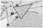
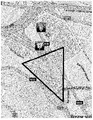
다른 시스템에서 디지털 지도를 사용하지 않으면서 POI들에 관한 경고들 및 다른 정보를 제공하는 것이 또한 알려져 있다. 그런 시스템들에서, POI들의 위치들은 모바일 디바이스 상에 로컬로 종종 저장된 데이터 저장소 내에 지리적인 좌표들, 예를 들면, 경도 및 위도로 저장되지만, 예를 들면, 중앙 서버로부터의 무선 통신에 의해 업데이트를 수신한 상기 모바일 디바이스에 의해 주기적으로 업데이트될 수 있을 것이다. 이 시스템들에서, 보통은 원뿔 형상인 검색 구역은 상기 디바이스의 전방에서 정의되며, 그리고 경보들 및 다른 정보가 이 검색 구역 내에 위치한 임의 POI들에 관련하여 사용자에게 제공된다. 이것은 상기 디바이스 상에서 필요한 저장 공간을 크게 줄어들게 하지만, 그것은 많은 불필요한 경보들 및 경고들이 사용자에게 제공되도록 이끌 수 있다. 이것은 도 1a, 도 1b 및 도 1c에서 예시된다. 도 1은 곡선 도로로 인한 부정 오류 (false negative)의 예, 즉, 경보가 없거나 늦은 경보를 예시한다. 이 예에서, 상기 디바이스는 위 왼쪽으로부터 오고 있으며, 그리고 상기 원뿔, 즉, 검색 구역은 그 도로에서의 구부러진 부분으로 인해서 POI (이 경우에는 과속 카메라)를 놓칠 것이다. 도 1b 및 도 1c는 긍정 오류 (false positive)의 예들, 즉, 관계없는 또는 통과하지 않을 POI들에 대한 경보를 예시하며; 이는 도로들이 평행할 때에 보통 발견된다.It is also known to provide alerts and other information about POIs without using digital maps in other systems. In such systems, the locations of the POIs are stored in geographical coordinates, e.g., longitude and latitude, in a data store, which is often stored locally on the mobile device, but may be updated by wireless communication from, for example, And may be periodically updated by the receiving mobile device. In these systems, a search area, usually in the form of a cone, is defined in front of the device, and alerts and other information are provided to the user in relation to any POIs located within the search area. This causes the required storage space on the device to be greatly reduced, but it can lead to many unnecessary alerts and warnings being provided to the user. This is illustrated in Figs. 1A, 1B and 1C. Figure 1 illustrates an example of a false negative due to a curved road, i.e., an alarm with no or late alarm. In this example, the device is coming from the upper left, and the cone, the search area, will miss the POI (in this case a speed camera) due to the bent portion on that road. Figures 1B and 1C illustrate examples of false positives, i.e., alerts for POIs that are irrelevant or will not pass; This is usually found when the roads are parallel.
본 발명의 목적은 상기 종래 기술의 문제점들 중 하나 또는 그 이상을 적어도 완화하는 것이다.It is an object of the present invention to at least alleviate one or more of the problems of the prior art.
본 발명의 첫 번째 모습에 따라 관심 포인트 (point of interest (POI))와 연관된 데이터를 제공하는 방법이 제공되며, 상기 방법은:According to a first aspect of the present invention there is provided a method of providing data associated with a point of interest (POI), the method comprising:
POI의 위치를 기반으로 하여 지리적 구역의 디지털 지도 데이터의 일부를 판별하는 단계로, 상기 디지털 지도 데이터는 상기 지리적 구역 내 운행가능 네트워크의 운행가능 요소들을 나타내는 복수의 세그먼트들을 포함하는, 단계; 그리고Determining a portion of the digital map data of the geographic area based on the location of the POI, wherein the digital map data comprises a plurality of segments representing the operable elements of the drivable network in the geographic area; And
디지털 지도 데이터의 상기 일부 내 적어도 몇몇의 세그먼트들을 나타내는 상기 POI와 연관된 POI-지도 데이터를 생성하는 단계를 포함한다.And generating POI-map data associated with the POI representing at least some segments within the portion of the digital map data.
일 실시예에서, 디지털 지도 데이터의 일부 판별은 상기 POI의 위치로부터의 반경을 기반으로 하여 상기 POI-지도의 범위를 결정하는 단계를 포함할 수 있다. 대안으로 디지털 지도 데이터의 일부 판별은 상기 POI로 이어지는 하나 이상의 경로들을 기반으로 하여 상기 POI-지도의 범위를 결정하는 단계를 포함할 수 있다. 이 실시예에서, 상기 방법은 상기 POI로 이어지는 복수의 경로들 및 각 경로의 범위를 결정하는 단계를 포함할 수 있다.In one embodiment, some determination of digital map data may include determining a range of the POI-map based on a radius from the location of the POI. Alternatively, some determination of the digital map data may include determining the range of the POI-map based on one or more paths leading to the POI. In this embodiment, the method may include determining a plurality of paths leading to the POI and a range of each path.
여기에서 사용되는 "세그먼트"는 본 발명이 속한 기술분야에의 일상적인 의미를 가진다. 세그먼트는 두 개의 노드들을 연결하는 운행가능 요소 (또는 링크), 또는 그것의 어떤 일부일 수 있다. 본 발명의 실시예들이 도로 세그먼트들을 참조하여 설명되지만, 본 발명은 보도, 강, 운하, 사이클 통로, 예항 통로, 철도 라인 등과 같은 다른 운행가능 세그먼트들에도 또한 적용 가능하다는 것이 인식되어야 한다. 참조의 편이를 위해서, 이것들은 도로 세그먼트로서 공통적으로 언급되지만, "도로 세그먼트"에 대한 언급은 "운행가능 세그먼트" 또는 그런 세그먼트들의 어떤 특정 유형이나 유형들에 대한 언급으로 대체될 수 있을 것이다. 상기 디지털 (또는 전자) 지도 데이터에 의해 표현되는 상기 운행가능 네트워크의 노드들은 실제 세계에서 운행가능 네트워크의 세그먼트들을 연결시키는 노드들, 예를 들면, 합류점들, 교차로들 등을 대표하는 노드들을 포함한다. 상기 전자 지도 데이터에 의해 표현된 노드들은 인위적인 노드들을 또한 포함할 수 있으며, 이것들은 실제 세계에서의 노드들로 표현되지 않는다. 예를 들면, 운행가능 요소를 따라 속도 제한이 변할 때에 인위적인 노드가 추가될 수 있다. 유시하게, 그리고 아래에서 더욱 상게하게 설명될 것처럼, 인위적인 노드는 관심 포인트 (POI)의 위치에서 운행가능 요소를 따라 추가될 수 있다.As used herein, the term "segment " has its ordinary meaning in the art to which the present invention pertains. A segment may be a runnable element (or link) connecting two nodes, or any part thereof. Although embodiments of the present invention are described with reference to road segments, it should be appreciated that the present invention is also applicable to other drivable segments such as sidewalks, rivers, canals, cycle paths, towing aisles, railway lines, and the like. For ease of reference, these are commonly referred to as road segments, but references to "road segments " may be replaced by references to" drivable segments "or any particular type or types of such segments. The nodes of the drivable network represented by the digital (or electronic) map data include nodes representative of nodes connecting, for example, segments of the drivable network in the real world, such as junctions, intersections, . The nodes represented by the electronic map data may also include artificial nodes, which are not represented by nodes in the real world. For example, an artificial node may be added when the speed limit changes along a serviceable element. As will be explained more freely, and below, an artificial node may be added along with the operable element at the location of the point of interest (POI).
실시예들에서, 상기 POI는 과속 방지 디바이스 (speed enforcement device (SED))일 수 있으며 그리고 상기 디지털 지도 데이터의 상기 일부는 상기 SED까지의 경고 거리나 경고 시간에 기초하여 판별될 수 있다.In embodiments, the POI may be a speed enforcement device (SED) and the portion of the digital map data may be determined based on a warning distance to the SED or a warning time.
상기 방법은 복수의 POI들을 저장하는 데이터베이스로부터 상기 POI를 선택하는 단계를 포함할 수 있다.The method may include selecting the POI from a database storing a plurality of POIs.
상기 방법에서 상기 POI-지도 데이터를 생성하는 단계는 상기 POI의 위치에서 상기 디지털 지도 데이터에 노드를 삽입하는 단계를 포함한다. 일 실시예에서, 상기 방법은 상기 노드와 연관된 POI의 특징들을 표시하는 하나 이상의 속성들을 저장하는 단계를 포함한다. 실시예들에서, 상기 POI는 SED이며 그리고 상기 하나 이상의 속성들은 SED의 유형 및 상기 SED의 방향 중 하나 또는 둘 모두를 표시한다.In the method, generating the POI-map data includes inserting a node into the digital map data at a location of the POI. In one embodiment, the method includes storing one or more attributes indicative of features of a POI associated with the node. In embodiments, the POI is a SED and the one or more attributes indicate one or both of the type of SED and the direction of the SED.
상기 POI-지도 데이터 생성은 적어도 하나의 도로 세그먼트를 나타내는 데이터와 연관된 속성을 저장하는 단계를 포함할 수 있으며, 여기에서 상기 속성은 상기 POI로 이어지는 더 낮은 확률을 가지는 도로 세그먼트를 나타낸다. 상기 POI로 이어지는 상기 확률은 상기 도로 세그먼트 및 상기 POI와 연관된 도로 세그먼트 사이의 각도를 기반으로 하여 결정될 수 있다. 추가로, 또는 대안으로, 상기 POI-지도 데이터 생성은 상기 POI에 도달할 수 없는 하나 이상의 도로 세그먼트들을 결정하는 단계를 포함할 수 있다. 추가로, 또는 대안으로, 상기 POI-지도 데이터 생성은 상기 POI에 도달할 수 없는 하나 이상의 도로 세그먼트들을 나타내는 데이터와 연관된 속성을 저장하는 단계를 포함할 수 있다.The POI-map data generation may include storing an attribute associated with data representing at least one road segment, wherein the property represents a road segment having a lower probability that leads to the POI. The probability following the POI may be determined based on the angle between the road segment and the road segment associated with the POI. Additionally or alternatively, generating the POI-map data may include determining one or more road segments that can not reach the POI. Additionally or alternatively, the POI-map data generation may include storing attributes associated with data representing one or more road segments that can not reach the POI.
상기 방법은상기 POI-지도 데이터를 데이터베이스에 저장하는 단계를 포함할 수 있다. 상기 POI-지도 데이터는 지리적 영역을 나타내는 셀과 연관하여 저장될 수 있다.The method may include storing the POI-map data in a database. The POI-map data may be stored in association with a cell representing a geographical area.
다른 모습으로부터 보면, 본 발명은 관심 포인트 (point of interest (POI))와 연관된 데이터를 제공하도록 준비된, 서버와 같은 컴퓨팅 디바이스를 제공하며, 상기 컴퓨팅 디바이스는:Viewed from another aspect, the present invention provides a computing device, such as a server, arranged to provide data associated with a point of interest (POI), said computing device comprising:
POI의 위치를 기반으로 하여 지리적 구역의 디지털 지도 데이터의 일부를 판별하는 수단으로, 상기 디지털 지도 데이터는 상기 지리적 구역 내 운행가능 네트워크의 운행가능 요소들을 나타내는 복수의 세그먼트들을 포함하는, 수단; 그리고Means for determining a portion of digital map data of a geographical area based on a location of a POI, said digital map data comprising a plurality of segments indicative of operable elements of a drivable network within said geographical area; And
디지털 지도 데이터의 상기 일부 내 적어도 몇몇의 세그먼트들을 나타내는 상기 POI와 연관된 POI-지도 데이터를 생성하는 수단을 포함한다.And means for generating POI-map data associated with the POI representing at least some segments within the portion of the digital map data.
본 발명은 컴퓨터로 구현된 발명이다. 상기 방법의 단계들 중 어느 하나를 수행하기 위한 수단은 그렇게 하도록 구성된, 예를 들면, 프로그램된 하나 이상의 프로세서들의 세트를 포함할 수 있다. 주어진 단계는 동일한 또는 상이한 프로세서들의 세트를 이용하여 어떤 다른 단계로 수행될 수 있다. 어떤 주어진 단계는 프로세서들의 세트들의 조합을 이용하여 수행될 수 있을 것이다.The present invention is a computer-implemented invention. The means for performing any of the steps of the method may comprise a set of one or more processors, for example, programmed to do so. A given step may be performed at some other step using the same or a different set of processors. Any given step may be performed using a combination of sets of processors.
상기 컴퓨팅 디바이스, 예를 들면, 서버는 상기 생성된 POI-지도 데이터를 데이터 저장부에 저장하기 위한 수단을 포함할 수 있다.The computing device, e.g., a server, may include means for storing the generated POI-map data in a data store.
상기 컴퓨팅 디바이스, 예를 들면, 서버는 상기 생성된 POI-지도 데이터 중 적어도 몇몇이 하나 이상의 모바일 디바이스들로 전달되도록 하는 통신 수단에 작동적으로 연결될 수 있다. The computing device, e.g., a server, may be operatively coupled to communication means for causing at least some of the generated POI-map data to be delivered to one or more mobile devices.
본 발명의 다른 모습에 따라, 관심 포인트 (POI)에 연관된 정보를 제공하는 방법이 제공되며, 상기 방법은:According to another aspect of the present invention there is provided a method of providing information associated with a point of interest (POI), the method comprising:
휴대용 디바이스의 판별된 지리적 위치를 나타내는 위치 정보를 서버 컴퓨터에게 전달하는 단계;Transmitting location information indicating a determined geographical location of the portable device to a server computer;
상기 위치 정보를 기반으로 하여 상기 서버 컴퓨터로부터 적어도 하나의 POI-지도를 수신하는 단계로, 각 POI-지도는 적어도 하나의 POI와 연관되며 그리고 운행가능 네트워크의 운행가능 요소들을 나타내는 세그먼트들을 포함하는, 수신 단계;Receiving at least one POI-map from the server computer based on the location information, wherein each POI-map is associated with at least one POI and comprises segments that represent operable elements of the operable network; Receiving step;
상기 휴대용 디바이스의 상기 판별된 지리적 위치에 대응하는 수신된 POI-지도의 세그먼트를 판별하는 단계; 그리고Determining a segment of the received POI-map corresponding to the determined geographic location of the portable device; And
상기 운행가능 세그먼트를 기반으로 하여 상기 수신된 POI-지도의 POI와 연관된 통지를 출력하는 단계를 포함한다.And outputting a notification associated with the POI of the received POI-map based on the drivable segment.
상기 POI-지도는 상기 세그먼트들 중 적어도 몇몇과 연관된 속성을 포함할 수 있으며, 상기 속성은 상기 POI로 이어지는 세그먼트의 가능성을 나타낸다. 통지의 유형은 상기 속성을 기반으로 할 수 있다. 상기 속성은 상기 POI로 이어지지 않는 연관된 세그먼트를 나타내는 값을 가질 수 있다; 상기 위치 정보가 상기 세그먼트에 대응할 때에 상기 POI와 연관된 통지의 출력이 방지될 수 있다.The POI-map may include an attribute associated with at least some of the segments, the attribute indicating the likelihood of a segment leading to the POI. The type of notification may be based on the attribute. The attribute may have a value indicating an associated segment that does not lead to the POI; The output of the notification associated with the POI can be prevented when the location information corresponds to the segment.
각 POI-지도의 세그먼트들은 상기 POI의 미리 정해진 거리 또는 미리 정해진 이동 시간 중 적어도 하나 내의 세그먼트들을 나타낼 수 있을 것이다. 실시예들에서, 상기 POI는 과속 방지 디바이스 (speed enforcement device)이며 그리고 상기 미리 정해진 거리는 미리 정해진 경고 거리이며 그리고 상기 미리 정해진 이동 시간은 미리 정해진 경고 시간이다. 상기 판별된 지리적 위치에 대응하는 세그먼트는 상기 지리적 위치 및 상기 세그먼트 주위의 바운딩 (bounding) 구역을 기반으로 하여 결정될 수 있다.Segments of each POI-map may represent segments within at least one of a predetermined distance or a predetermined travel time of the POI. In embodiments, the POI is a speed enforcement device and the predetermined distance is a predetermined warning distance and the predetermined travel time is a predetermined warning time. The segment corresponding to the determined geographic location may be determined based on the geographic location and a bounding zone around the segment.
실시예들에서, POI-지도를 활용하는가의 여부에 관한 결정은 상기 지리적 위치 및 상기 POI 사이의 거리, 그리고 상기 지리적 위치 및 상기 POI-지도의 범위 중 하나를 기반으로 한다. 상기 POI-지도는 상기 거리가 제1 거리보다 작을 때에 활용될 수 있을 것이다. 추가로, 또는 대안으로, 상기 POI-지도 사용은 상기 거리가 제2 거리보다 더 클 때에 중단될 수 있다.In embodiments, the determination as to whether or not to utilize the POI-map is based on one of the distance between the geographical location and the POI, and the geographical location and the range of the POI-map. The POI-map may be utilized when the distance is less than the first distance. Additionally or alternatively, the POI-map usage may be interrupted when the distance is greater than the second distance.
상기 수신된 적어도 하나의 POI-지도는 실시예들에서 상기 디바이스와 연관된 메모리 내에 저장될 수 있다. POI-지도는 상기 디바이스의 지리적 위치에 기초하여 상기 메모리로부터 삭제될 수 있다. 예를 들면, POI-지도는 상기 지리적 위치가 상기 POI-지도와 연관된 POI로부터 미리 정해진 거리보다 더 멀 때에 삭제될 수 있다. The received at least one POI-map may be stored in a memory associated with the device in embodiments. The POI-map may be deleted from the memory based on the geographic location of the device. For example, a POI-map may be deleted when the geographic location is farther than a predetermined distance from the POI associated with the POI-map.
다른 모습으로부터 보면, 본 발명은 관심 포인트 (POI)와 연관된 정보를 제공하는 내비게이션 디바이스와 같은 휴대용 디바이스를 제공하며, 상기 휴대용 디바이스는:Viewed from another aspect, the present invention provides a portable device, such as a navigation device, that provides information associated with a point of interest (POI), said portable device comprising:
상기 휴대용 디바이스의 판별된 지리적 위치를 나타내는 위치 정보를 서버 컴퓨터에게 전달하는 수단;Means for communicating location information indicating a determined geographic location of the portable device to a server computer;
상기 위치 정보를 기반으로 하여 상기 서버 컴퓨터로부터 적어도 하나의 POI-지도를 수신하는 수단으로, 각 POI-지도는 적어도 하나의 POI와 연관되며 그리고 운행가능 네트워크의 운행가능 요소들을 나타내는 세그먼트들을 포함하는, 수신 수단;Means for receiving at least one POI-map from the server computer based on the location information, wherein each POI-map is associated with at least one POI and comprises segments that represent operable elements of the operable network; Receiving means;
상기 휴대용 디바이스의 상기 판별된 지리적 위치에 대응하는 수신된 POI-지도의 세그먼트를 판별하는 수단; 그리고Means for determining a segment of the received POI-map corresponding to the determined geographic location of the portable device; And
상기 운행가능 세그먼트를 기반으로 하여 상기 수신된 POI-지도의 POI와 연관된 통지를 출력하는 수단를 포함한다.And means for outputting a notification associated with the POI of the received POI-map based on the drivable segment.
본 발명은 컴퓨터로 구현된 발명이다. 상기 방법의 단계들 중 어느 하나를 수행하기 위한 수단은 그렇게 하도록 구성된, 예를 들면, 프로그램된 하나 이상의 프로세서들의 세트를 포함할 수 있다. 주어진 단계는 동일한 또는 상이한 프로세서들의 세트를 이용하여 어떤 다른 단계로 수행될 수 있다. 어떤 주어진 단계는 프로세서들의 세트들의 조합을 이용하여 수행될 수 있을 것이다.The present invention is a computer-implemented invention. The means for performing any of the steps of the method may comprise a set of one or more processors, for example, programmed to do so. A given step may be performed at some other step using the same or a different set of processors. Any given step may be performed using a combination of sets of processors.
예를 들면, 어떤 실시예에서, 상기 휴대용 (또는 모바일) 디바이스는: 상기 디바이스의 지리적 위치를 판별하기 위한 로케이션 모듈; 서버와 무선으로 통신하기 위한 통신 모듈; 그리고 상기 방법의 단계들을 수행하도록 준비된 프로세서를 포함한다.For example, in some embodiments, the portable (or mobile) device comprises: a location module for determining a geographic location of the device; A communication module for wirelessly communicating with the server; And a processor arranged to perform the steps of the method.
본 발명에 따른 상기 방법들 중 어느 것은 적어도 부분적으로 소프트웨어, 예를 들면, 컴퓨터 프로그램들을 이용하여 구현될 수 있다. 본 발명은 그래서 본 발명의 실시예들이나 모습들 중 어느 하나에 따른 방법을 수행하도록 실행될 수 있는 컴퓨터 판독가능 명령어들을 포함하는 컴퓨터 프로그램으로 또한 확장된다.Any of the above methods according to the present invention may be implemented, at least in part, using software, e.g., computer programs. The invention thus extends also to a computer program comprising computer-readable instructions that can be executed to perform a method according to any of the embodiments or aspects of the present invention.
본 발명은, 데이터 프로세싱 수단을 포함하는 시스템이나 장치를 동작시키기 위해 사용될 때에 상기 데이터 프로세싱 수단과 함께 상기 장치나 시스템으로 하여금 본 발명의 상기 방법의 단계들을 수행하도록 하는 그런 소프트웨어를 포함하는 컴퓨터 소프트웨어 캐리어로 대응하여 확장된다. 그런 컴퓨터 소프트웨어 캐리어는 ROM 칩, CD ROM 또는 디스크와 같은 비 일시적인 물리적 저장 매체일 수 있으며, 또는 와이어들을 통산 전자 신호, 위성으로의 광학적 신호 또는 라디오 신호 등과 같은 신호일 수 있다.The present invention also relates to a computer software carrier comprising such a software for causing the device or system to perform the steps of the method of the present invention in conjunction with the data processing means when used to operate a system or device comprising data processing means . Such a computer software carrier may be a non-transitory physical storage medium such as a ROM chip, CD ROM or disk, or may be a signal such as an electronic signal, an optical signal to a satellite, a radio signal, or the like.
명시적으로 선언되지 않은 경우에, 본 발명은 자신 모습들 중 어느 것에서도 본 발명의 다른 모습들이나 실시예들에 관하여 설명된 특징들 중 어느 하나 또는 모두를 그것들이 상호 배타적인지 않은 한도까지 포함할 수 있다는 것이 인정될 것이다. 특히, 동작들의 다양한 실시예들이 상기 방법에서 그리고 상기 장치에 의해 실행되는 것으로 설명되었지만, 이 동작들 중 하나 이상 또는 모두는 원하는대로 그리고 적절하게 상기 방법에서 그리고 상기 장치에 의해 임의 조합으로 수행될 수 있을 것이라는 것이 인정될 것이다. Where not explicitly stated, the present invention encompasses any or all of the aspects described herein with respect to other aspects or embodiments of the invention to the extent that they are not mutually exclusive It will be recognized that it can be. In particular, although various embodiments of the operations have been described as being performed in the method and by the apparatus, one or more or all of these operations may be performed in any manner and in any combination, It will be recognized that there will be.
이 실시예들의 이점들이 지금부터 제시되며, 그리고 이 실시예들 각각의 추가의 상세 내용들 및 특징들은 동반하는 종속 청구항들 및 이어지는 상세한 설명의 다른 곳에서 정의된다.The advantages of these embodiments are now presented, and the additional details and features of each of these embodiments are defined elsewhere in the accompanying dependent claims and the subsequent detailed description.
본 발명의 효과는 본 명세서의 해당되는 부분들에 개별적으로 명시되어 있다.The effects of the present invention are specified separately in the relevant portions of this specification.
본 발명의 실시예들은 첨부된 도면들을 참조하여 단지 예로서만 이제 설명될 것이다.
도 1a, 도 1b 및 도 1c는 경고들 또는 정보가 제공될 POI들의 존재를 판별하기 위한 예시적인 통상적 방법을 도시한다.
도 2는 POI들을 포함하는 지도 데이터의 예시적인 일부를 도시한다.
도 3은 POI-지도들을 생성하기 위한 예시적인 시스템을 도시한다.
도 4는 본 발명의 실시예에 따라 POI-지도들을 생성하기 위한 방법을 도시한다.
도 5는 본 발명에 따른 POI-지도의 범위를 도시한다.
도 6은 본 발명의 실시예에 따른 POI-지도의 표현 및 지도 데이터를 도시한다.
도 7은 POI-지도의 예시적인 인접 목록 표현을 도시한다.
도 8은 본 발명의 실시예에 따른 내비게이션 디바이스의 개략적인 레이아웃을 도시한다.
도 9는 본 발명의 실시예에 따라 POI와 연관된 정보를 제공하는 방법을 보여준다.
도 10은 본 발명의 실시예에 따른 POI-지도들의 예시를 보여준다.
도 11은 POI-지도에 관한 본 발명의 실시예의 동작을 도시한다.
도 12는 POI-지도에 관한 본 발명의 실시예의 동작을 더 도시한다.Embodiments of the present invention will now be described, by way of example only, with reference to the accompanying drawings.
Figures 1A, 1B and 1C illustrate an exemplary conventional method for determining the presence of alerts or POIs to be provided with information.
Figure 2 shows an exemplary portion of map data including POIs.
Figure 3 illustrates an exemplary system for generating POI-maps.
Figure 4 illustrates a method for generating POI maps according to an embodiment of the present invention.
Figure 5 shows the range of POI maps according to the invention.
FIG. 6 illustrates a POI-map representation and map data according to an embodiment of the present invention.
Figure 7 shows an exemplary neighbor list representation of a POI-map.
8 shows a schematic layout of a navigation device according to an embodiment of the present invention.
Figure 9 illustrates a method of providing information associated with a POI in accordance with an embodiment of the present invention.
Figure 10 shows an example of POI maps according to an embodiment of the present invention.
Figure 11 illustrates the operation of an embodiment of the present invention with respect to a POI-map.
Figure 12 further illustrates the operation of an embodiment of the present invention with respect to POI-maps.
본 발명의 실시예들은 관심 포인트 (point of interest (POI))와 연관된 지도 정보를 제공하기 위한 방법 및 장치를 포함한다. 그 지도 정보는 각 POI의 근방에 있는 운행가능 경로들을 나타내는 데이터이다. 본 발명의 추가의 실시예들은 상기 관심 포인트 (POI)와 연관된 수신된 지도 정보를 이용하여 통지 또는 경고와 같이 POI와 연관된 정보를 제공하기 위한 방법 및 장치를 포함한다. 본 발명의 예시적인 실시예들은 소위 말하는 과속 카메라들과 같은 과속 방지 디바이스 (speed enforcement device)들을 POI들로서 참조하여 설명될 것이지만, 본 발명의 실시예는 이런 면으로 제한되지 않는다는 것이 인식될 것이다.Embodiments of the present invention include a method and apparatus for providing map information associated with a point of interest (POI). The map information is data indicating possible travel routes in the vicinity of each POI. Additional embodiments of the present invention include a method and apparatus for providing information associated with a POI, such as a notification or alert, using received map information associated with the POI. It will be appreciated that while exemplary embodiments of the present invention will be described with reference to speed enforcement devices, such as so-called overspeed cameras, as POIs, embodiments of the invention are not limited in this respect.
과속 방지 디바이스 (speed enforcement device (SED))는 도로와 연관된 속도 제한을 강제하기 위해서 그 도로의 일부에 가깝게 배치된다. 상기 SED는 어떤 위치에 배치되어, 즉, 분리된 지리적 위치에서 그 위치를 지나가는 차량들의 속도를 모니터하며, 또는 도로의 섹션에 걸쳐서, 예를 들면 도로의 1km (또는 다른 거리)에 걸쳐서 차량의 속도를 모니터하도록 준비될 수 있다. 상기 속도 제한보다 더 높을 수 있을 미리 정해진 속도를 차량이 초과할 때에, 강제적인 집행이 취해지도록 하기 위해 그 차량에 연관된 정보, 예를 들면 등록 세부사항들이나 차량의 이미지를 컴퓨터 시스템으로 전달하는 것과 같은 적절한 행동이 취해질 수 있다. 내비게이션 디바이스의 위치가 SED의 위치에 접근할 때에 그 내비게이션 디바이스가 경고를 제공하는 것은 잘 알려진 것이다.A speed enforcement device (SED) is placed close to a portion of the road to enforce a speed limit associated with the road. The SED monitors the speed of vehicles that are located at a certain location, i. E., In a separate geographic location, past the location, or over a section of the road, for example over a distance of 1 km (or other distance) Lt; / RTI > Such as, for example, transferring registration details or an image of the vehicle to a computer system so that forced enforcement is taken when the vehicle exceeds a predetermined speed that may be higher than the speed limit Appropriate behavior can be taken. It is well known that the navigation device provides a warning when the location of the navigation device approaches the location of the SED.
위에서 설명되었듯이, 도로 네트워크를 나타내는 지도 데이터를 포함하지 않은 내비게이션 디바이스에 의한 그런 경고를 제공하는 것으로의 한가지 종래 접근 방식은 SED들의 지리적 위치들을 나타내는, 상기 내비게이션 디바이스에게 액세스 가능한 SED 데이터를 저장하는 것이다. 상기 내비게이션 디바이스는 상기 내비게이션 디바이스의 위치가 SED의 위치로부터 미리 정해진 거래 내에 있는가의 여부 그리고 상기 내비게이션의 진로 및 상기 SED 중 하나 또는 둘 모두로부터의 각을 이룬 투사 또는 원뿔이 교차하는가의 여부를 판별한다. 일단 상기 원뿔들이나 투사들이 교차하면, 상기 내비게이션 디바이스는 SED의 존재를 표시하는 경고를 출력하도록 준비된다. 이런 접근 방식은, 예를 들면, (예를 들면, 도 1a, 도 1b 및 도 1c에서처럼) 상기 SED가 상기 내비게이션 디바이스의 이동 방향 반대편에서 속도 제한을 강제하거나 또는 상기 내비게이션 디바이스가 이동하고 있는 도로에 인접한 도로 상에 상기 SED가 준비되어 있지만, 상기 내비게이션 디바이스의 상기 원뿔 또는 각을 이룬 투사 내에 위치하여 경고가 출력되도록 하는 경우에는 잘못된 경고들을 제공하는 경향이 있다.As described above, one conventional approach to providing such a warning by a navigation device that does not include map data representing a road network is to store SED data accessible to the navigation device, which represents the geographic locations of the SEDs . The navigation device determines whether the position of the navigation device is within a predetermined transaction from the position of the SED and whether the angled projection or cone crosses from one or both of the navigation and the SED . Once the cones or projections intersect, the navigation device is ready to output a warning indicating the presence of the SED. This approach can be used, for example, to determine whether the SED enforces a speed limit on the opposite side of the direction of travel of the navigation device (e.g., as in FIGS. 1A, 1B and 1C) or on the road on which the navigation device is moving Although the SED is prepared on adjacent roads, it tends to provide false alarms when placed in the cone or angled projection of the navigation device to cause a warning to be output.
경고를 제공하는 다른 종래 접근 방식은 지도 데이터 및 상기 지도 데이터의 도로 세그먼트와 연관되는 것처럼 상기 지도 데이터와 연관된 SED들의 지리적 위치들을 나타내며 상기 지도 데이터와 조합될 수 있을 SED 데이터를 저장하는 내비게이션 디바이스와 결부된다. 도 2는 복수의 노드들 (명료함을 위해서, 이것들 모두에 참조번호가 부여되지는 않는다)을 상호 연결시키는 복수의 도로 세그먼트들을 포함하는 지도 데이터 (100)의 일부를 도시한다. 특히, 상기 지도 데이터는 제1 도로 세그먼트 (110) 및 제2 도로 세그먼트 (120)를 포함하며, 이 세그먼트들 각각은 제1 SED (130) 및 제2 SED (140)와 연관되며, 이 SED들의 위치들은 X로 표시된다. 상기 SED들 (130, 140)의 위치들은 상기 지도 데이터의 일부에 관하여 정의될 수 있으며, 예컨대, 상기 제1 SED (130)의 위치는 노드 (111)로부터 도로 세그먼트 (110)를 따라 50m처럼 정의될 수 있을 것이다. 상기 SED들의 위치들은 다른 방식들로 정의될 수 있다는 것이 실감될 것이다. 상기 내비게이션 디바이스는 내비게이션 디바이스의 지리적 위치를 상기 지도 데이터와 비교하여, 상기 내비게이션 디바이스가 이동하고 있는 상기 지도 데이터의 도로 세그먼트를 결정하도록 준비된다. 예를 들면, 상기 내비게이션 디바이스는 자신의 현재 위치가 도로 세그먼트 (110)를 따른 어떤 위치에 대응하는가를 수신된 신호들을 기반으로 하여 판별할 수 있다. 상기 내비게이션 디바이스가 상기 SED (130)가 위치한 도로 세그먼트 상 위치에 접근할 때에, 상기 내비게이션 디바이스는 경고를 제공하도록 준비된다. 이 접근 방식이 더욱 정밀한 경고들을 제공할 수 있을 것이지만, 지도 데이터 및 SED 데이터를 저장하기 위해 많은 양의 저장 공간이 필요하다. 예를 들면, 어떤 지역을 위한 지도 데이터 및 SED 데이터는 200MB일 수 있다. 그래서, 이 접근 방식은, 예를 들면 스마트폰들과 같은 일반적인 컴퓨팅 디바이스들 상에서 구현된 것들처럼 더 작은 리소스들을 가진 내비게이션 디바이스들에게 덜 적합하다. Another conventional approach to providing an alert is to associate with a navigation device that stores geographic locations of SEDs associated with the map data as well as associated map data and road segments of the map data and stores SED data that may be combined with the map data do. Figure 2 shows a portion of the
도 3은 본 발명의 실시예에 따른 시스템 (200)을 도시한다. 상기 시스템 (200)은 서버 컴퓨터 (210), 지도 데이터베이스 (220), POI 데이터베이스 (230) (비록 이것이 필요하다면 임의의 하나 이상 유형의 POI의 데이터베이스일 수 있지만, 이것은 일 실시예에서는 SED들의 데이터베이스이다) 그리고 POI-지도 데이터베이스 (250)를 포함한다. 상기 서버 컴퓨터 (210)는 하나 이상의 컴퓨팅 유닛들로서 구현될 수 있을 것이며, 그 컴퓨팅 유닛들은 자신들의 적어도 하나의 프로세서 상에서 POI-지도 모듈 (POI-map module (POIM))을 작동적으로 실행하도록 준비된 유닛들이다. 상기 서버 컴퓨터 (210)는 상기 지도 데이터베이스 (220) 및 상기 SED 데이터베이스 (230)에 통신 가능하게 연결된다. 상기 서버 컴퓨터 (210)는 상기 지도 데이터베이스 (220) 및 상기 SED 데이터베이스 (230)를 저장할 수 있을 것이며 또는 이것들은 상기 서버 컴퓨터 (210)에게 통신 가능하게 연결된 다른 컴퓨터 시스템에 의해 제공될 수 있을 것이다. 상기 지도 데이터베이스 (220) 및 상기 SED 데이터베이스 (230)는 분리된 데이터 구조들로서 제공될 수 있을 것이며 또는 단일의 데이터 구조 또는 데이터베이스로 통합될 수 있을 것이다.Figure 3 illustrates a
상기 지도 데이터베이스 (220)는 네트워크 내 운행가능 실제-세계의 통로들을 나타내는 디지털 지도 데이터를 저장하도록 준비된다. 상기 지도 데이터는 노드들을 상호연결시키는 세그먼트들을 나타내는 정보로부터 형성될 수 있으며, 여기에서 상기 세그먼트들은 운행가능 네트워크를 표시한다. 대안으로 상기 지도 데이터는 연관된 속성들을 가진 노드들에 의해 형성될 수 있을 것이며, 여기에서 적어도 몇몇의 속성들은 노드들 사이에서의 연결들을 표시하며, 그 노드들은 자신들 사이에서의 연결을 나타내는 공통의 속성들을 가지는 노드들이다. 상기 연결들은 실제 세계에서의 운행가능 세그먼트들을 나타낸다. 상기 운행가능 세그먼트들은 도로 세그먼트들일 수 있지만, 싸이클이나 통로망과 같은 임의의 운행가능 네트워크의 세그먼트들일 수도 있다. 상기 지도 데이터는 상이한 방식으로 구축될 수 있을 것이라는 것이 인식될 것이다.The
상기 SED 데이터베이스 (230)는 과속 방지 디바이스의 위치들을 나타내는 SED 데이터를 저장하도록 준비된다. 상기 SED들의 위치들은 상기 지도 데이터에 대해서 정의될 수 있을 것이며, 예컨데, SED (130)의 위치는 특정 노드로부터의 도로 세그먼트를 따른 거리로서 정의될 수 있을 것이다. 상기 SED들의 위치들은 위치-참조 시스템, 예컨대, 위도 및 경도와 같은 좌표 시스템을 참조하여 대안으로 정의될 수 있을 것이다. 상기 SED들의 위치들은 다른 방식들로 정의될 수 있을 것이라는 것이 인식될 것이다. 더욱이, 상기 SED 데이터는 상기 지도 데이터와 조합될 수 있을 것이라는 것 또한 인식될 것이다. 본 발명이 SED들을 참조하여 설명되지만, 상기 SED들은 다른 유형의 POI를 나타내는 데이터일 수 있다는 것이 인식될 것이다. The
상기 지도 데이터베이스 (220) 및 SED 데이터베이스 (230)는 하나 이상의 국가들이나 주들과 같은 지리적 영역에 대한 지도 데이터 및 SED 데이터를 각각 저장한다.The
상기 POIM (240)은 상기 지도 데이터베이스 (220) 및 SED 데이터베이스 (230)을 기반으로 하여 POI-지도를 생성하도록 준비된다. 각 POI-지도는 상기 지도 데이터베이스 (220)가 데이터를 저장하는 대상인 지리적 영역보다 더 작은 지리적 영역에 대한 지도 데이터를 포함한다. 몇몇의 실시예들에서, 설명될 것처럼, 상기 POI-지도는 연관된 POI 부근 내에서 선택된 도로들을 나타낸다. 상기 POI가 SED인 경우에 상기 POI-지도는 경고 시간 또는 거리를 기반으로 하는 지리적 영역에 대해 생성된다. 상기 POI-지도는 상기 POIM (240)에 의해 이전에 생성된 POI-지도 데이터베이스 (250) 내에 저장된다. The
본 발명의 실시예에 따른 POIM (240)의 동작은 도 4에서 도시된 본 발명의 실시예에 따른 방법 그리고 도 5 및 도 6에서 보이는 예시의 지도 데이터를 참조하여 설명될 것이다. 상기 방법 (300)은 상기 서버 컴퓨터 (210) 상에서 작동적으로 실행되는 POIM (300)에 의해 수행될 수 있다.The operation of the
상기 방법 (300)은 SED와 같은 POI가 선택되는 단계 310을 포함한다. 상기 방법은 복수의 POI들 각각에 대해 반복될 수 있을 것이라는 것이 인식될 것이다. 상기 POI가 SED인 경우에, 상기 SED는 SED 데이터베이스 (230)로부터 선택될 수 있다. 상기 방법 (300)은 그 선택된 POI에 대해 POI-지도를 생성한다. 상기 방법은 SED를 예시의 POI로서 참조하여 설명되지만, 본 발명의 실시예들은 그런 면으로 제한되지 않는다는 것이 인식될 것이다. 상기 POI는 관심의 특징이 주차장, 공항, 소매 아웃렛, 이력적인 관심 사이트처럼 존재하는 임의의 장소일 수 있다.The
단계 320은 상기 POI를 디지털 지도 데이터의 일부에 연관시키는 단계를 포함한다. 특히, 단계 320은 상기 지도 데이터 내에서 정의된 하나 이상의 도로 세그먼트들에 관한 위치처럼 상기 POI와 연관된 지도 데이터의 범위를 결정하는 단계를 포함한다. SED 데이터가 SED들의 위치들을 상기 지도 데이터와 독립적으로 정의하는 경우에, 상기 선택된 SED를 적어도 하나의 도로 세그먼트와 연관시키는 것이 필요할 수 있으며, 이는 상기 지도 데이터 내의 어느 도로 세그먼트가 상기 SED와 연관되는가를 판별하고 그리고 상기 도로 세그먼트를 따른 SED의 위치를 판별하기 위한 것이다. 몇몇의 경우들에서, 상기 SED는 도로 세그먼트의 길이 방향을 따른 도로 세그먼트의 일부와 연관될 수 있으며, 또는 제1 도로 세그먼트를 따른 위치로부터 제2 도로 세그먼트를 따른 위치까지와 같은 복수의 도로 세그먼트들과 연관될 수 있다. 몇몇의 SED들은 도로 상의 정확한 단일 포인트에서가 아니라 도로의 섹션을 따른 차량들의 속도를 모니터하도록 준비된다는 것이 인정될 것이다.Step 320 includes associating the POI with a portion of the digital map data. In particular,
위에서 언급된 것처럼, 상기 POI가 SED인 경우에, 상기 POI-지도의 범위는, 일 실시예에서, 경고 거리 또는 시간을 기반으로 한다. 예시적인 실시예에서, POI-지도의 범위는 15초의 경고 시간을 기반으로 하며, 비록 그렇다고 하더라도 다른 경고 시간이 선택될 수 있다는 것이 인식될 것이다. 상기 POI-지도의 범위는 적어도 경고 시간 내에 이동될 것으로 예상되는 거리여서, 상기 SED를 향하여 상기 POI-지도 내에서 정의된 도로 세그먼트들을 운행하면서, 상기 SED에 대한 경고가 제공될 수 있도록 한다. 상기 POI-지도의 범위는 적어도 상기 SED로부터의 경고 거리이다. 상기 POI-지도의 범위는 상기 경고 거리 또는 상기 경고 시간 내에서 이동될 것으로 예상되는 거리와 동일할 수 있다. 상기 경고 시간 내에 이동될 것으로 예상되는 거리는 상기 POI가 위치한 도로 세그먼트와 연관된 속도 제한에 기초할 수 있는 예상된 최대 이동 속도를 기반으로 하여 계산될 수 있다. 예를 들면, 비록 다른 최대 예상 이동 속도들이 선택될 수 있을 것이지만, 상기 최대 예상 이동 속도는 상기 도로와 연관된 속도 제한의 두 배일 수 있다. 상기 POI-지도의 범위는, 예를 들면, 상기 POI로부터 5km 미만, 2km 미만, 또는 1km 미만일 수 있다. 상기 POI-지도는 단 하나의 POI와 연관될 수 있을 것이다.As mentioned above, if the POI is SED, the range of POI-maps is based on warning distance or time, in one embodiment. In the exemplary embodiment, the range of the POI-map is based on a warning time of 15 seconds, and it will be appreciated that even though other warning times may be selected. The range of the POI-map is a distance that is expected to be moved at least within the warning time, so that a warning for the SED can be provided while driving the road segments defined in the POI-map toward the SED. The range of the POI-map is at least the warning distance from the SED. The range of the POI-map may be equal to the warning distance or the distance expected to be moved within the warning time. The distance expected to be moved within the warning time may be calculated based on the expected maximum travel speed, which may be based on the speed limit associated with the road segment where the POI is located. For example, although other maximum expected travel speeds may be selected, the maximum expected travel speed may be twice the speed limit associated with the road. The range of the POI-map may be, for example, less than 5 km, less than 2 km, or less than 1 km from the POI. The POI-map may be associated with only one POI.
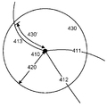
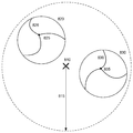
일 실시예에서, 상기 POI-지도의 범위는 상기 POI 지도의 범위에 대응하는 반경을 가진 원으로서 결정된다. 도 5a는 세 개의 도로 세그먼트들 (411, 412, 413)에 연결된 노드 (410)를 포함하는 지도 데이터베이스 (220)로부터의 지도 데이터의 일부를 도시한다. 경고 시간 또는 경고 거리에서 이동될 것으로 예상된 거리에 대응하는 반경이 참조번호 420으로 도시된다. 그래서, 일 실시예에서, 상기 POI-지도의 범위는 상기 반경 (420)을 기반으로 하는 상기 지도 데이터의 원형의 일부 (430)이다. 상기 POI 지도는 상기 SED로부터 단일 방향성일 수 있다는 것이 인식될 것이며, 즉, 상기 SED가 도로를 따른 한 방향에서 속도 제한을 강제할 수 있도록만 준비된 경우에, 반대 방향에서 상기 SED로 향하여 이동하는 차량에게는 경고를 제공하는 것은 불필요한 것으로 간주될 수 있다. 그런, 상기 POI-지도의 범위는 원형일 필요는 없으며 그리고, 예를 들면, 상기 SED가 속도 제한을 강제하는 방향으로 향하는 상기 SED의 위치로부터 확장하는 섹터일 수 있다.In one embodiment, the range of the POI-map is determined as a circle having a radius corresponding to the range of the POI map. 5A shows a portion of map data from a
다른 실시예에서, 상기 POI의 범위는 상기 POI의 위치로 이어지는 적어도 몇몇의 경로들을 기반으로 하여 결정된다. 즉, 단계 320은 예상되는 이동 거리 또는 경고 거리의 POI로 이어지는 경로를 따른 위치를 판별하는 단계를 포함할 수 있으며, 여기에서 상기 위치는 상기 POI-지도의 범위에 대응한다. 그러므로 이 방식으로 생성된 POI-지도는 원형과 같은 균일한 형상을 가지지 않을 수 있을 것이며, 이는 상기 POI로부터의 POI-지도의 범위가 도로 세그먼트들의 방향성에 따라 변하기 때문이며, 즉, 곡선 도로 세그먼트들은 상기 범위가 상기 POI로부터의 대응 진행방향에서 축소되도록 하기 때문이다. 예를 들면, 도 4를 참조하면, 도로 세그먼트 (413)를 따른 상기 POI-지도의 범위는 도로 세그먼트 (413)의 굴곡으로 인해 참조번호 420의 원형 범위보다 더 짧은 거리 (430')로서 결정될 수 있다. 모든 도로 세그먼트들 (411, 412, 413)을 따른 거리가 결정될 수 있으며 그리고 각 도로 세그먼트를 따라 결정된 위치를 적절한 곡선들이나 직선들에 의해 연결함으로써 POI-지도의 형상이 결정될 수 있다. 유리하게도 이런 접근방식은 상기 POI-지도에서 관련된 영역들만을 포함한다. 이 실시예에서 단계 320은 상기 POI (410)로 이어지는 모든 경로들을 판별하는 단계 그리고 상기 경로들 각각을 따른 상기 POI-지도의 범위를 결정하는 단계를 포함할 수 있다.In another embodiment, the range of the POI is determined based on at least some of the paths leading to the location of the POI. That is,
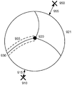
일 실시예에서, 상기 POI-지도의 범위는, SED의 유형처럼, 연관된 POI의 속성을 기반으로 한다. 도 5b는 도로 세그먼트들 (451-455)를 포함하는 지도 데이터 (450)의 일부를 도시한다. SED는 제1 위치 (461) 및 제2 위치 (462) 사이의 도로 세그먼트 (454)를 따른 차량들의 속도를 모니터하도록 준비된다. 이 경우에, POI-지도의 범위는 상기 제1 위치 (461) 및 제2 위치 (462) 사이에 있는 것으로 결정될 수 있으며, 또는 도 5b에서 단속선으로 표시된 것처럼, 상기 POI-지도의 범위는 상기 SED에 의해 적어도 부분적으로 모니터되는 도로 세그먼트들, 즉, 이 예에서는 참조번호 454의 도로 세그먼트를 포함할 수 있을 것이다. 몇몇의 SED들은 상기 제1 위치 (461) 및 제2 위치 (462) 사이에서 차량들의 평균 속도를 모니터하도록 준비되며, 그러므로, 상기 제1 위치 (461) 및 제2 위치 (462) 중 어느 하나를 지나가면 일단 경고를 제공하는 것만이 필요하며 그래서 POI-지도의 범위는 축소될 수 있을 것이며, 다른 SED들은 상기 제1 위치 (461) 및 제2 위치 (462) 사이에서 차량들의 최대 속도를 모니터할 수 있으며, 그러므로 도로 세그먼트 (454)에 진입할 때의 경고가 소망될 수 있다. 그래서, 상기 POI-지도의 범위는 일 실시예에서는 SED의 유형과 같은 POI의 유형에 종속적이라는 것이 인정될 수 있다.In one embodiment, the range of POI-maps is based on the attributes of the associated POI, such as the type of SED. FIG. 5B shows a portion of the
단계 330은 POI-지도 내에 포함하기 위해 관련된 도로 세그먼트들을 결정하는 단계를 포함한다. 일 실시예에서 POI-지도의 범위 내에서 상기 지도 데이터베이스 (220) 내 모든 도로 세그먼트들은 상기 POI-지도 내에 포함된다. 그러나, 다른 실시예들에서 상기 POI-지도는 선택된 도로 세그먼트들을 포함할 뿐이다. 그 선택된 도로 세그먼트들은 단지 상기 POI로 이어질 높은 확률을 가진 것들일 수 있다. 도로는 그 도로가 상기 POI가 위치한 도로이거나 상기 POI가 위치한 도로로 직접적으로 이끄는 도로라면 상기 POI로 이어질 높은 확률을 가질 수 있다. 상기 POI가 위치한 도로로 직접적으로 이어지는 도로는, 예를 들면, 상기 위치 POI가 위치한 도로 세그먼트에 인접한 도로 세그먼트의 축, 그리고 상기 POI가 위치한 도로 세그먼트의 축 사이의 미리 정해진 각도보다 더 작은 것일 수 있다. Step 330 includes determining relevant road segments for inclusion in the POI-map. In one embodiment, all road segments within the
도 6은 메이저 도로와 주변의 마이너 도로들을 구비한 다양한 도로들을 포함하는 지도 데이터의 영역을 도시한다. SED (510)는 도 5에서 표시된 도로에 인접하게 위치한다. 단계 330에서, 상기 SED (510)이 이 도로 상에 위치하기 때문에 상기 메이저 도로는 관련된 도로인 것으로 결정된다. 그래서, 도 6에 도시되듯이, POI-지도의 범위 내 상기 메이저 도로에 대응하는 도로 세그먼트 (520)는 상기 POI-지도 내에 포함된다. 상기 POI-지도 내 POI-지도 범위 그리고 상기 SED (510)의 위치 사이에 도로 세그먼트를 포함시키기 위해서, 상기 SED (510)에 대응하는 위치에 상기 지도 데이터베이스에 저장된 지도 데이터 내 도로 세그먼트를 따라 새로운 노드가 삽입될 수 있다. SED가 도로 세그먼트의 중간 위치에 있기 때문에 상기 지도 데이터베이스 (220)에 저장된 상기 지도 데이터에서 노드는 SED (510)의 위치에 존재하지 않을 수 있다는 것이 인식될 것이다. 노드들은 상기 POI-지도의 외부 범위에서 도로 세그먼트들의 경계를 짓기 위해 또한 삽입될 수 있다. 그래서 단계 330은 SED와 같은 상기 POI (510)의 위치로 도로 세그먼트를 트리밍하는 단계 그리고 상기 POI의 위치에서 노드를 삽입하는 단계를 포함할 수 있다.Figure 6 shows an area of map data including various roads with major roads and surrounding minor roads. The
단계 340은 옵션이며 상기 방법 (300)의 몇몇의 실시예들로부터 삭제될 수 있을 것이다. 단계 340에서, 상기 SED (510)로 이어질 가능성이 있는 하나 이상의 도로 세그먼트들이 결정된다. 그것은 POI로 이어질 특정 확률보다 더 작은 확률을 가진 것이다. 도로 세그먼트 상의 차량이 SED (510)를 지나갈 확률이 미리 정해진 값보다 더 작다면 그 도로 세그먼트는 SED (510)로 이어질 가능성이 있는 것으로 간주될 수 있을 것이다. 일 실시예에서, 미리 정해진 하나보다 많은 각이 상기 POI가 위치한 도로 세그먼트에 인접한 도로 세그먼트의 축 그리고 상기 POI가 위치한 도로 세그먼트의 축 사이에 존재한다면, 상기 차량이 SED (510)를 지나갈 확률은 상기 미리 정해진 값보다 더 작다. 예를 들면, 단속선들을 구비한 도 5에서 보이는 도로 세그먼트들 (530 및 540)은 SED (510)가 위치한 도로 세그먼트 (520)에 연결된다. 그러나, 각 도로 세그먼트 그리고 상기 도로 세그먼트 (510) 사이에 각도 (531, 541)가 존재한다. 그러므로, 이 도로 세그먼트들 (530, 540)은 상기 SED (510)으로 이어질 더 낮은 확률을 가지는 것으로 간주된다. 상기 POI-지도에서 상기 도로 세그먼트들 (530, 540)을 나타내는 데이터는 상기 SED (510)로 이어지는 자신들 각자의 더 낮은 확률을 표시하는 식별자와 연관될 수 있을 것이다. Step 340 is optional and may be deleted from some embodiments of the
단계 340은 상기 POI로 이어지는 더 낮은 확률들을 각각 가지는 도로 세그먼트의 하나 이상의 카테고리들을 식별하는 단계를 포함할 수 있다. 예를 들면, 미리 정해진 각도보다 더 큰 복수의 모퉁이들을 경유하여 상기 SED (510)가 위치한 도로 세그먼트를 연결하는 도로 세그먼트들은, 더 작은 가능성을 가지고, 추가 카테고리로서 식별될 수 있으며 그리고 추가의 식별자들을 구비한 POI-지도에서 식별될 수 있다. 상기 하나 이상의 추가의 카테고리들의 도로들은, 상기 POI-지도를 수신했으며, 예를 들면, 참조번호 530의 도로 세그먼트를 따라 이동하는 내비게이션 디바이스에 의해 사용되어 SED (510)에 대한 경고를 생성할 수 있으며, 이는 상기 내비게이션 디바이스가 참조번호 520의 도로 세그먼트를 따라 이동하고 있을 때보다 덜 엄격하다. 도로 세그먼트들 사이에서의 각도가 하나 이상의 더 낮은 확률들을 위한 기초를 제공하는 것으로서 설명되었지만, 상기 더 낮은 확률을 결정하기 위해 도로 세그먼트들의 다른 속성들이나 특징들이 사용될 수 있을 것이라는 것이 인식될 것이다. Step 340 may include identifying one or more categories of road segments, each having lower probabilities leading to the POI. For example, road segments connecting the road segments where the
단계 350은 옵션이며, 상기 방법 (300)의 몇몇의 실시예들에서는 생략될 수 있을 것이다. 단계 350에서, 상기 POI-지도의 범위 내에서, POI에 도달될 수 없는 하나 이상의 도로 세그먼트들이 식별된다. 특히, 단계 350은 상기 SED와 연관되지 않는 하나 이상의 도로 세그먼트들을 결정하는 것을 포함할 수 있다.Step 350 is optional and may be omitted in some embodiments of the
상기 POI-지도는, 예를 들면, SED (510)에 접근할 때에 사용자에게 경고하는가의 여부를 결정하기 위해서 내비게이션 디바이스에 의해 사용된다. 종래 기술들에서의 한 문제점은 위에서 설명되었듯이 오류-경고들을 발행하는 것이다. 내비게이션 디바이스는, 상기 내비게이션 디바이스 또는 그 내비게이션 디바이스와 연관된 차량이 이동하고 있는 도로 세그먼트를 판별하기 위해 상기 POI-지도를 이용한다. 무선 신호들에 기초하여 상기 내비게이션 디바이스에 의해 판별된 위치는 상기 POI-지도 내 도로 세그먼트들의 위치들에 대해 비교되어, 적합한 도로 세그먼트, 즉, 상기 디바이스가 위치한 현재 도로 세그먼트, 그리고 상기 디바이스의 도로 세그먼트를 따른 위치를 판별한다. 몇몇의 경우들에서, 상기 내비게이션 디바이스 근방은 도로 세그먼트들이 상대적으로 밀집하여 위치할 수 있을 것이다. 예를 들면, 상기 내비게이션 디바이스는 다른 도로와 나란하게 통한 도로를 따라서 이동할 수 있을 것이며, 또는 도로의 높아진 섹션은 상기 내비게이션 디바이스가 위치한 도로 머리 위로 가깝게 지나갈 수 있을 것이다. 이런 경우들에서 상기 내비게이션 디바이스는 자신의 위치가 상기 SED (510)가 위치한 도로 세그먼트에 대응한다고 틀리게 판별하고 그리고 잘못된-경고를 발행할 수 있을 것이다.The POI-map is used by the navigation device to determine, for example, whether to warn the user when approaching the
단계 350에서 상기 POI-지도의 범위 내에 있지만 상기 SED (510)에는 도달할 수 없는 또는 도달하기에는 미리 정해진 확률 미만을 가진 하나 또는 그 보다 많은 도로 세그먼트들이 식별된다. 이 도로 세그먼트들은 상기 POI-지도 내 적절한 식별자와 연관된다. 그래서 상기 내비게이션의 위치가 상기 POI-지도 내 그런 식별된 도로 세그먼트에 대응한다고 판별된다면, 잘못된-경고가 방지될 수 있을 것이다. 상기 SED (510)에 도달될 것 같지 않은 또는 도달될 수 없는 그런 도로 세그먼트들을 생략하는 것은 상기 내비게이션 디바이스가 자신의 위치를 상기 SED (510)에 도달될 수 있을 도로 세그먼트들에 대응한다고 판별하도록 할 수 있을 것이다. At
단계 360에서 상기 POI-지도가 생성된다. 상기 POI-지도는 단계 330에서 식별된 적어도 도로 세그먼트들을 나타내는 POI-지도 데이터를 출력하는 POIM (240)에 의해 생성된다. 상기 POIM (240)은 단계들 340 및 350에서 식별된 도로 세그먼트들 중 하나 또는 둘 모두를 나타내는 데이터를 또한 출력할 수 있다.At step 360, the POI-map is generated. The POI-map is generated by the
상기 POI-지도는 그래프로서, 특히 인접지 목록으로서 생성될 수 있다. 그런 인접지 목록에서 노드들을 나타내는 데이터는 인접한 노드들의 목록와 연관하여 저장된다. 도로 세그먼트들은 노드들의 인접지에 의해 표시된다. 예를 들면, 도 7은 네 개의 노드들: 노드 0; 노드 1; 노드 2; 및 노드 3을 그 노드들 사이에서의 지향성 연결들과 함께 보여준다. 도 7의 배치는 다음의 방식으로 인접지 목록으로서 저장될 수 있다:The POI-map can be generated as a graph, in particular as a contiguous list. Data representing nodes in such a neighbor list is stored in association with a list of neighboring nodes. The road segments are represented by adjacent nodes. For example, Figure 7 shows four nodes:
[0]: {Node 0}: [ 0 ] 노드 0는 떠나가는 어떤 연결도 가지지 않는다[0]: {Node 0}: [0]
[1]: {Node 1}: [ {0} , {2} ] 노드 1은 노드 0 및 노드 2로 떠나는 연결들을 가진다[1]: {Node 1}: [{0}, {2}]
[2]: {Node 2}: [ {0} ] 노드 2는 노드 0으로 떠나는 연결들을 가진다[2]: {Node 2}: [{0}] Node 2 has connections leaving to
[3]: {Node 3}: [ {2} ] 노드 3은 노드 2로 떠나는 연결들을 가진다[3]: {Node 3}: [{2}] Node 3 has connections leaving to node 2
상기 POI-지도 데이터는 노드가 나타내는 지리적인 위치와 같이 각 노드에 대한 하나 이상의 속성들을 나타내는 데이터를 포함할 수 있다. 상기 지리적인 위치는 경도 및 위도 좌표들에 의해 식별될 수 있다. 상기 SED를 나타내는 노드는 SED의 유형을 나타내는 속성과 연관될 수 있다. 상기 속성은, 예를 들면, 상기 SED가 모바일 SED, 즉, 휴대용 또는 이동가능 SED (고정된 SED와는 반대임)라는 것, 순간 속도, 최대 속도, 평균 속도와 같은 SED의 유형 등을 표시할 수 있다. 다른 유형의 POI들이 상기 노드에 의해 표현되는 경우에 적합한 속성들이 저장되어 상기 POI를 나타낼 수 있을 것이라는 것이 인식될 것이다. The POI-map data may include data representing one or more attributes for each node, such as the geographic location that the node represents. The geographic location may be identified by longitude and latitude coordinates. The node representing the SED may be associated with an attribute indicating the type of SED. The attribute may indicate, for example, that the SED is a mobile SED, i.e., a portable or mobile SED (as opposed to a fixed SED), a type of SED such as instantaneous speed, maximum speed, have. It will be appreciated that if other types of POIs are represented by the node, the appropriate attributes will be stored to indicate the POI.
상기 POI 지도 데이터는 상기 도로 세그먼트의 길이, 속도 및 유형 또는 분류 중 하나 또는 그 이상을 표시하는 도로 세그먼트 속성들을 포함할 수 있을 것이며, 몇몇의 실시예들에서 위에서 설명된 것처럼, 분류의 유형은 도로 세그먼트가 단계들 340 또는 350에서 식별되는가의 여부를 확인한다The POI map data may include road segment attributes indicative of one or more of the length, speed and type or classification of the road segments, and as described above in some embodiments, It is checked whether the segment is identified in
몇몇의 실시예들에서 상기 POI-지도 데이터는 각 도로 세그먼트의 기하학적 구조를 적어도 대략적으로 정의한다. 예를 들면, 각 도로 세그먼트의 기하학적 구조는 하나 이상의 커브들 또는 형상 포인트들을 기반으로 하여 정의될 수 있다. 이 방식에서 POI-지도 데이터를 수신하는데 있어서의 내비게이션 디바이스는 노드의 지리적인 위치 그리고 그 노드와 연관된 도로 세그먼트의 기하학적 구조를 기반으로 하여 상기 디바이스의 위치에 대응하는 도로 세그먼트를 더욱 정밀하게 결정할 수 있다.In some embodiments, the POI-map data at least roughly defines the geometry of each road segment. For example, the geometry of each road segment may be defined based on one or more curves or shape points. In this manner, the navigation device in receiving the POI-map data can more precisely determine the road segment corresponding to the location of the device based on the geographic location of the node and the geometry of the road segment associated with that node .
단계 360에서 상기 POI-지도는 POI-지도 데이터베이스 (250)에 저장된다. 단계 360은 POI-지도 데이터를 하나 이상의 적절한 식별자들와 연관된 데이터베이스로 삽입하는 단계를 포함할 수 있다. 예를 들면 상기 POI-지도 데이터는 국가와 같은 지리적인 구역 내 지리적인 영역 또는 셀과 연관될 수 있을 것이다. 상기 셀은 상기 지리적인 구역의 일부를 한정할 수 있다. 상기 지리적인 구역은 각각이 하나 이상의 POI-지도들과 연관된 복수의 셀들로 분할될 수 있을 것이다. 그래서 단계 360에서 복수의 POI-지도들이 식별될 수 있을 것이며, 이것들 모두는 한 셀 내의 또는 인접 셀 내의 내비게이션 디바이스로 함께 전달되기 위해 상기 한 셀과 연관된다. In step 360, the POI-map is stored in the POI-
단계 370에서, 어떤 추가의 POI들이 상기 지도 데이터베이스 (220) 내에 남아있는가의 여부가 판별된다. 상기 방법 (300)은 상기 SED 데이터베이스 (230)에 저장된 복수의 SED들에 대한 것처럼 복수의 POI들 각각에 대해 반복될 수 있다. 그렇다면, 상기 방법은 단계 310으로 돌아가며, 그 단계 310에서 다음의 POI가 선택된다. 그렇지 않다면 상기 방법은 종료한다.At
상기 방법 (300)이 복수의 POI들에 대해 되풀이하여 반복되면, 상기 POI-지도 데이터베이스 (250)는 상기 복수의 POI들 각각에 대해 POI-지도 데이터를 저장한다. 상기 POI-지도 데이터는 각 POI 근방의 적어도 몇몇의 도로 세그먼트들을 나타낸다. 상기 방법 (300)은 상기 SED 데이터베이스에 추가된 새로운 SED들과 같은 새 POI들에 대해 반복될 수 있다. 예를 들면, 모바일 SED의 위치를 나타내는 데이터가 상기 SED 데이터베이스 (230)에 추가될 수 있으며 그리고 상기 방법 (300)은 그 새로운 SED에 대해 반복된다.If the
POI-지도 데이터는 상기 서버 컴퓨터 (210) 또는 상기 POI-지도 데이터베이스 (250)에 통신가능하게 연결된 다른 컴퓨터에 의해 내비게이션 디바이스로 전달될 수 있다. 상기 서버 컴퓨터 (210)는 상기 내비게이션 디바이스의 위치를 나타내는 위치 데이터를 예를 들면 상기 내비게이션 디바이스와 함께 설립된 무선 통신 채널을 경유하여 수신할 수 있다. 응답으로 상기 서버 (210)는 상기 내비게이션 디바이스의 위치가 POI 지도 데이터베이스 (250) 내 임의 POI들에서 미리 정해진 거리 내에 있는가의 여부를 판별하고 그리고 그 POI들에 대한 POI-지도 데이터를 상기 내비게이션 디바이스에게 전달한다. 상기 미리 정해진 거리는, 예를 들면, 5km 또는 10km일 수 있다. 이 방식에서 상기 내비게이션 디바이스는 국가와 같은 전체 지리적 구역을 위한 지도 데이터를 저장할 것을 필요로 하지 않으면서, 자신의 위치가 상기 POI와 연관된 도로 세그먼트에 대응하는가의 여부를 상기 POI-지도 데이터를 기반으로 하여 정확하게 판별할 수 있다. 상기 내비게이션 디바이스는 미리 정해진 시간 이후에 또는 상기 내비게이션 디바이스의 위치가 상기 POI로부터 미리 정해진 거리보다 더 멀리 이동했을 때에, 저장되었던 POI-지도 데이터를 제거할 수 있다.The POI-map data may be communicated to the navigation device by the
본 발명의 실시예들이 내비게이션 디바이스를 참조하여 위에서 설명되었지만, 본 발명의 실시예들은 그렇게 한정되지 않는다는 것이 인식될 것이다. 상기 데이터베이스 (250)에 저장된 POI-지도들은 어떤 모바일 디바이스에도 유용할 수 있다. 상기 모바일 디바이스는 프로세서, 데이터를 저장하기 위한 메모리, 상기 모바일 디바이스 (150)의 위치를 판별하기 위한 모듈 그리고 그 모바일 디바이스에게 POI-지도를 제공하는 서버와 통신할 수 있도록 하기 위한 데이터 통신용 통신 모듈을 포함한다. 상기 모바일 디바이스는 적절한 소프트웨어를 작동적으로 실행하는 스마트폰, 테블릿 또는 랩탑 컴퓨터와 같은 컴퓨팅 디바이스일 수 있다. 예를 들면, 상기 모바일 디바이스는 상기 디바이스의 위치가 SED의 위치로 접근할 때에 경고를 제공할 수 있다. SED들이 보통은 높은 사고율을 가진 위치들에 배치되기 때문에, 그런 경고들은 높은 사고율 장소라는 경고를 제공함으로써 안전을 향상시킨다. 몇몇의 예들에서 그런 디바이스는 내비게이션 기능성을 또한 제공할 수 있을 것이며 또는 제공하지 않을 수 있을 것이다. 내비게이션 기능성은 사용자가 적어도 목적지 위치를 상기 디바이스에 입력하고 그리고 그 위치로의 경로 안내를 수신할 수 있는 기능을 포함할 수 있다. 상기 모바일 디바이스는 위에서 설명된 내비게이션 디바이스와 같은 디바이스일 수 있다. 내비게이션 디바이스는 차량 내에서 사용하기 위한 디바이스이며, 상기 디바이스의 위치에 가까운 관심 포인트와 연관된 통지와 같이 그 디바이스의 현재 근접한 곳에 관한 내비게이션 정보를 제공할 수 있다. 비록 내비게이션 디바이스들이 내비게이션 위성 신호들을 사용하는 것으로 한정되지는 않으며 그리고 위치-판별을 위해 Wi-Fi 및 셀룰러 통신 신호들과 같은 다른 무선 신호들을 사용할 수 있다는 것이 인식될 것이지만, 공통적으로 모바일 디바이스들은 위성 신호 수신 및 프로세싱 기능성을 포함한다. While embodiments of the present invention have been described above with reference to a navigation device, it will be appreciated that embodiments of the invention are not so limited. The POI maps stored in the
본 발명의 실시예들은 관심 포인트들 부근의 지도 데이터를 제공하기 위한 방법들 및 장치들을 제공한다는 것이 인식될 것이다. 상기 지도 데이터는 모바일 디바이스로 제공될 수 있으며, 그래서 상기 모바일 디바이스가 전체 지리적 구역을 위한 데이터를 저장할 필요성을 줄어들게 한다. 상기 데이터는 관심 포인트 근방에서의 내비게이션을 제공하기 위해, 또는 그 관심 포인트와 연관된 통지를 제공하기 위해 상기 모바일 디바이스에 의해 사용될 수 있다. 특히, 본 발명의 실시예들은 과속 방지 디바이스의 위치에 대한 경고를 제공하기 위해 사용될 수 있다. 상기 경고를 제공하기 위해 지도 데이터를 이용함으로써 잘못된-경고들의 가능성이 줄어들며, 국가와 같은 지리적 구역을 위한 데이터를 저장하는 저장 패널티를 초래하지도 않는다. It will be appreciated that embodiments of the present invention provide methods and apparatus for providing map data in the vicinity of points of interest. The map data may be provided to a mobile device, thereby reducing the need for the mobile device to store data for the entire geographic area. The data may be used by the mobile device to provide navigation near a point of interest, or to provide a notification associated with the point of interest. In particular, embodiments of the present invention may be used to provide an alert for the position of the overspeed protection device. Using the map data to provide the alert reduces the likelihood of false-alerts and does not result in a storage penalty for storing data for geographic areas such as a country.
위에서 논의된 것처럼, 본 발명의 실시예들은 POI와 연관된 수신 지도 정보를 기반으로 하여 모바일 디바이스, 예를 들면, 내비게이션 디바이스를 이용하여 통지 또는 경고와 같은 상기 POI와 연관된 정보를 제공하는 것에 또한 관련된다.As discussed above, embodiments of the present invention also relate to providing information associated with the POI, such as notifications or alerts, using a mobile device, e.g., a navigation device, based on the received map information associated with the POI .
POI와 연관된 지도 정보를 저장하는 내비게이션 디바이스는 그 내비게이션 디바이스가 위치하고 있거나 또는 이동하고 있는 도로 또는 운행가능 세그먼트를 판별할 수 있다. 이 방식에서 상기 내비게이션 디바이스는 상기 POI와 연관된 통지 또는 경고와 같은 정보를 출력하는가의 여부를 정확하게 결정할 수 있다. 상기 내비게이션 디바이스는 그 지도 정보를 기반으로 하여 상기 POI 근방에서 또한 운항할 수 있을 것이다. 그러나, 상기 내비게이션 디바이스가 국가와 같은 전체 지리적 구역을 위한 지도 및 POI 정보를 저장하는 것은 필요하지 않다.The navigation device storing the map information associated with the POI may determine the road or drivable segment on which the navigation device is located or moving. In this way, the navigation device can accurately determine whether to output information such as notifications or warnings associated with the POI. The navigation device will also be able to navigate around the POI based on the map information. However, it is not necessary for the navigation device to store maps and POI information for the entire geographic area, such as a country.
본 발명의 실시예에 따른 내비게이션 디바이스는 수신한 무선 신호들로부터 자신의 지리적인 위치를 판별할 수 있고, POI와 연관된 지도 정보를 수신하기 위해 서버 컴퓨터와 무선으로 통신할 수 있으며 그리고 상기 내비게이션 디바이스의 지리적인 위치를 기반으로 하여 상기 POI와 연관된 정보를 출력할 수 있는 디바이스이다. 상기 내비게이션 디바이스는 적절한 소프트웨어를 실행하는 휴대용 컴퓨팅 디바이스에 의해 구현될 수 있을 것이다. 상기 소프트웨어는 사용자가 적어도 원하는 목적지를 입력하는 것을 허용하고 상기 소프트웨어가 그 목적지까지의 경로 안내를 제공하는 것을 허용하는 것과 같은 내비게이션 기능성을 제공할 수 있다. 추가적으로 또는 대안으로 상기 소프트웨어는 상기 내비게이션 디바이스가 SED의 지리적인 위치에 접근하고 있을 때에 경고와 같은 POI에 대한 통지 또는 경고 기능성을 제공할 수 있다. 이런 의미에서 상기 내비게이션 디바이스는 SED 경고 디바이스일 수 있다. 그러므로 간명함을 위해서 상기 내비게이션 디바이스는 경로 계획 기능성 또는 예컨대 계획된 경로에 대한 안내 기능성을 제공할 수 있을 필요가 있는 것이 필수는 아니라는 것이 인정될 것이다. A navigation device according to an embodiment of the present invention may determine its geographical location from received wireless signals and wirelessly communicate with a server computer to receive map information associated with the POI, And is a device capable of outputting information related to the POI based on a geographical location. The navigation device may be implemented by a portable computing device executing suitable software. The software may provide navigation functionality, such as allowing a user to enter at least a desired destination and allowing the software to provide route guidance to its destination. Additionally or alternatively, the software may provide notification or alert functionality to POIs such as alerts when the navigation device is approaching the geographic location of the SED. In this sense, the navigation device may be an SED alert device. It will therefore be appreciated that for simplicity the navigation device is not required to be capable of providing path planning functionality or guidance functionality, e.g., for a planned path.
도 8은 본 발명의 바람직한 실시예에 따른 내비게이션 디바이스 (600)의 전자 컴포넌트들의 블록 컴포넌트 포맷인 예시적인 표현이다. 상기 내비게이션 디바이스 (600)의 블록 도면은 상기 내비게이션 디바이스의 모든 컴포넌트들을 포함하는 것은 아니며, 많은 예시의 컴포넌트들의 대표일 뿐이라는 것에 유의해야 한다.8 is an exemplary representation of a block component format of electronic components of a
상기 내비게이션 디바이스 (600)는 하우징 (도시되지 않음) 내에 위치한다. 상기 하우징은 입력 디바이스 (620) 및 디스플레이 스크린 (640)에 연결된 프로세서 (610)를 포함한다. 입력 디바이스 (620)는 키보드 디바이스, 음성 입력 디바이스, 터치 패널 및/또는 정보를 입력하기 위해 활용되는 어떤 다른 알려진 입력 디바이스를 포함할 수 있다; 그리고 상기 디스플레이 스크린 (640)은 예를 들면 LCD 디스플레이와 같은 임의 유형의 디스플레이 스크린을 포함할 수 있다. 특히 바람직한 설비에서 상기 입력 디바이스 (620) 및 디스플레이 스크린 (640)은 터치 패드나 터치스크린을 포함하는 통합된 입력 및 디스플레이 디바이스로 통합되며, 그래서 사용자가 복수의 디스플레이 선택들 중 하나를 선택하기 위해 또는 복수의 가상 버튼들 중 하나를 활성화하기 위해 상기 디스플레이 스크린 (640)의 일부를 터치하는 것만을 필요로 하게 한다. The
상기 내비게이션 디바이스는 출력 디바이스 (660), 예를 들면, 청각적인 출력 디바이스 (예컨대, 라우드스피커)를 포함할 수 있다. 출력 디바이스 (660)가 내비게이션 디바이스 (600)의 사용자를 위해 청각적인 정보를 산출할 수 있기 때문에, 입력 디바이스 (640)는 입력 음성 명령들을 수신하기 위한 마이크로폰 및 소프트웨어를 마찬가지로 포함할 수 있다는 것이 동등하게 이해되어야 한다. The navigation device may include an
상기 내비게이션 디바이스 (600)에서, 상기 프로세서 (610)는 참조번호 625의 접속을 경유하여 입력 디바이스 (620)에 작동적으로 연결되어 입력 정보를 수신하도록 세팅되며, 그리고 참조번호 645의 출력 접속들을 경유하여 디스플레이 스크린 (640) 및 출력 디바이스 (660) 중 적어도 하나에 작동적으로 연결되어 그것들에게 정보를 출력한다. 또한 상기 프로세서 (610)는 참조번호 635의 접속을 경유하여 메모리 리소스 (630)에 작동적으로 연결되며 그리고 참조번호 675의 접속을 경유하여 입력/출력 (I/O) 포트들 (670)로부터/에게 정보를 수신하고/송신하도록 더 적응되며, 여기에서 상기 I/O 포트 (670)는 상기 내비게이션 디바이스 (600)의 외부인 I/O 디바이스 (680)로 연결 가능하다. 상기 메모리 리소스 (630)는 예컨데 랜덤 액세스 메로리 (RAM)와 같은 휘발성 메모리 그리고 비-휘발성 메모리, 예를 들면, 플래시 메모리와 같은 디지털 메모리를 포함한다. 상기 외부 I/O 디바이스 (680)는 예를 들면 이어폰과 같은 외부 청취 디바이스를 포함할 수 있지만, 그것으로 제한되지는 않는다. I/O 디바이스 (680)로의 접속은 핸즈-프리 동작을 위해 그리고/또는 예를 들면 음성 활성 동작을 위해, 이어폰이나 헤드폰으로의 접속을 위해, 그리고/또는 예를 들면 모바일 폰으로의 접속을 위해 카 스테레오와 같은 어떤 다른 외부 디바이스로의 유선의 또는 무선의 접속을 더 포함할 수 있으며, 여기에서 상기 모바일 접속은 상기 내비게이션 디바이스 (600) 및 예를 들면 인터넷이나 어떤 다른 네트워크 사이에서의 데이터 접속을 설립하기 위해 그리고/또는 예를 들면 인터넷이나 몇몇의 다른 네트워크를 경유하여 서버로의 접속을 설립하기 위해서 사용될 수 있다.In the
도 8은 참조번호 655의 접속을 경유한 상기 프로세서 (610) 및 안테나/수신기 (650) 사이에서의 작동 접속을 더 도시하며, 여기에서 상기 안테나/수신기 (650)는 예를 들면 GPS와 같은 글로벌 내비게이션 위성 시스템 (global navigation satellite system (GNSS)) 안테나/수신기일 수 있다. 참조번호 650에 의해 표시된 상기 안테나 및 수신기는 예시를 위해 개략적으로 결합된 것이며, 상기 안테나 및 수신기는 분리하여 위치한 컴포넌트들일 수 있으며, 그리고 상기 안테나는 예를 들면 GNSS 패치 안테나 또는 나선형 안테나일 수 있다는 것이 이해될 것이다.8 further illustrates an operational connection between the
또한, 도 8에서 보이는 전자 컴포넌트들은 통상적인 방식으로 전력 소스들 (도시되지 않음)에 의해 전력을 공급받는다는 것은 본 발명이 속한 기술 분야에서의 통상의 지식을 가진 자에 의해 이해될 것이다. 본 발명이 속한 기술 분야에서의 통상의 지식을 가진 자가 이해할 것처럼, 도 8에서 보이는 컴포넌트들의 상이한 구성들은 본원의 범위 내에 있는 것으로 간주된다. 예를 들면, 도 8에서 보이는 컴포넌트들은 유선 및/또는 무선 접속들 등을 경유하여 서로 통신할 수 있다. 그래서, 본원의 상기 내비게이션 디바이스 (600)의 범위는 휴대용 또는 핸드헬드 내비게이션 디바이스 (600)를 포함한다.It will also be understood by those of ordinary skill in the art that the electronic components shown in FIG. 8 are powered by power sources (not shown) in a conventional manner. As one of ordinary skill in the art would understand, the different configurations of the components shown in FIG. 8 are considered to be within the scope of the present disclosure. For example, the components shown in FIG. 8 may communicate with each other via wired and / or wireless connections, and the like. Thus, the scope of the
추가로, 도 8의 휴대용 또는 헨드헬드 내비게이션 디바이스 (600)는 예를 들면, 모터바이크나 차와 같은 차량에 알려진 방식으로 연결되거나 "도킹"될 수 있다. 그런 내비게이션 디바이스 (600)는 휴대용 또는 헨드헬드 내비게이션 사용을 위해 상기 도킹된 위치로부터 그 후에 탈착 가능하다. Additionally, the portable or hand-held
상기 내비게이션 디바이스 (600)는 (예를 들면, 알려진 블루투스 기술을 경유한 디지털 접속과 같은) 디지털 접속을 설립하는 모바일 디바이스 (도시되지 않음) (예를 들면, 모바일 폰, PDA 및/또는 모바일 폰 기술을 구비한 디바이스)를 경유하여 POI-지도 데이터베이스 (250)와 통신하는 서버와 같은 서버와 "모바일" 또는 원거리 통신 네트워크 접속을 설립할 수 있다. 그 후, 자신의 네트워크 서비스 제공자를 통해서, 상기 모바일 디바이스는 (예를 들면, 인터넷을 통해) 상기 서버와 네트워크 접속을 설립할 수 있다. 그처럼, "모바일" 네트워크 접속이 상기 내비게이션 디바이스 (800) (이는 단독으로 그리고/또는 차량 내에서 포함되어 이동하기 때문에 모바일일 수 있으며, 그리고 때로는 모바일이다) 그리고 상기 서버 사이에 설립되어, 정보용의 "실시간" 또는 적어도 아주 "최신의" 게이트웨이를 제공한다. The
상기 내비게이션 디바이스 (600)는 그 내비게이션 디바이스 (600) 그 자체 내에 자기 자신의 모바일 폰 기술을 포함할 수 있다 (예를 들면, 안테나를 포함하며, 또는 옵션으로는 상기 내비게이션 디바이스 (600)의 내부 안테나를 이용한다). 상기 내비게이션 디바이스 (600) 내 모바일 폰 기술은 위에서 상술된 내부 컴포넌트들을 포함할 수 있으며, 그리고/또는 필수적인 모바일 폰 기술 및/또는 예를 들면 안테나로 채워진 삽입 가능 카드 (예를 들면, 가입자 신원 모듈 (Subscriber Identity Module) 또는 SIM 카드)를 포함할 수 있다, 그처럼, 상기 내비게이션 디바이스 (600) 내 모바일 폰 기술은 임의 모바일 디바이스와 유사한 방식으로 예를 들면 인터넷을 경유하여 상기 내비게이션 디바이스 (600)와 서버 사이에서의 네트워크 접속을 유사하게 설립할 수 있다.The
도 9는, 예를 들면, POI-지도 데이터베이스 (250)로부터 무선으로 POI-지도 데이터를 수신할 수 있는 본 발명의 실시예에 따른 내비게이션 디바이스 (600) 상에서 POI와 연관된 정보를 제공하는 방법을 도시한다.Figure 9 illustrates a method for providing information associated with a POI on a
상기 방법 (700)은 내비게이션 디바이스 (600)의 위치를 판별하는 단계 (710)를 포함한다. 단계 710은 위성 내비게이션 신호들 (예컨대, GPS, 갈릴레오 등), Wi-Fi, 원거리통신 신호들 등 처럼 수신된 무선 신호들로부터 자신의 위치를 판별하는 상기 내비게이션 디바이스 (600)에 의해 수행될 수 있다. 예를 들면, 상기 프로세서 (610)는 안테나 (650)에 의해 무선으로 수신된 GPS 신호들에 기반하여 상기 내비게이션 디바이스 (600)의 위치를 판별할 수 있다. 비록 다른 위치 참조 시스템들이 사용될 수 있을 것이라는 것이 인식될 것이지만, 상기 위치는 경도와 위도로서 표시될 수 있을 것이다.The
단계 720에서 상기 위치를 나타내는 정보가 서버 컴퓨터로 전달된다. 상기 정보는 상기 내비게이션 디바이스 (600)로부터, 상기 내비게이션 디바이스 (600)가 적어도 주기적으로 통신 가능하게 연결된 상기 서버 컴퓨터로 전달될 수 있다.In
몇몇의 실시예들에서 710 및 720 단계들은 상기 내비게이션 디바이스 (600)의 위치가 상기 서버 컴퓨터에 의해 판별되는 단계로 대체될 수 있을 것이라는 것이 인식될 것이다. 예를 들면, 상기 내비게이션 디바이스 (600)의 위치는 상기 내비게이션 디바이스가 통신 가능하게 연결된 원거리통신 네트워크를 기반으로 하여 판별될 수 있을 것이다.It will be appreciated that in some embodiments,
단계 730은 상기 내비게이션 디바이스가, 예를 들면, 위에서 설명된 모습의 하나 또는 그 이상의 POI-지도들을 수신하는 단계를 포함한다. 상기 하나 또는 그 이상의 POI-지도들은 상기 서버로부터 상기 내비게이션 디바이스 (600)로 무선 통신 채널을 경유하여 전달된다. 상기 서버는 상기 내비게이션 디바이스 (600)로의 전달을 위해 상기 하나 또는 그 이상의 POI-지도들을 선택하도록 준비된다. 상기 선택은 단계 720에서 상기 내비게이션 디바이스 (600)로부터 상기 서버 컴퓨터로 전달된 상기 위치를 나타내는 정보를 기반으로 할 수 있을 것이다. 상기 서버 컴퓨터는 POI-지도들의 데이터베이스, 예를 들면, 도 2에서 보이는 데이터베이스 (250)와 같은 POI-지도들의 저장소와 연관된다. 비록 그것들로 제한되지 않는다는 것이 인식될 것이지만, POI-지도들의 저장소는 하나 이상의 국가나 국토와 같은 지리적인 구역을 위한 것일 수 있다. 각 POI-지도는 각자의 관심 포인트 (POI)와 연관된다. 예시적인 일 실시예에서 적어도 몇몇의 POI-지도들은 SED들과 연관된다.Step 730 includes the step of the navigation device receiving, for example, one or more POI-maps of the aspects described above. The one or more POI maps are communicated from the server to the
도 10을 참조하면, 상기 서버는 상기 내비게이션 디바이스 (600)의 위치 (810)의 미리 정해진 반경 (815) 내에서 POI들을 위한 POI-지도들을 선택하도록 준비된다. 상기 POI들을 선택하기 위한 다른 방법들이 사용될 수 있을 것이라는 것이 인식될 것이다. 예를 들면, 상기 위치 (810)에 대응하는, 즉, 상기 위치가 그 내부에 존재하는 타일 내 POI들이 선택될 수 있을 것이다.Referring to FIG. 10, the server is ready to select POI-maps for POIs within a
도 10에서 도시된 예에서, 제1 POI (825) 및 제2 POI (835)가 상기 내비게이션 디바이스의 위치의 반경 (815) 내에 존재하는 것으로서 선택된다. 상기 제1 POI (825) 및 제2 POI (835)와 연관된 POI-지도들 (820, 830)이 단계 730에서 상기 서버로부터 상기 내비게이션 디바이스 (600)로 전달된다. POI-지도들은 그러면 내비게이션 디바이스 (600)의 메모리 (630)에 저장된다.In the example shown in FIG. 10, a
상기 제1 POI-지도 (820)는 상기 제1 POI (825) 그리고 그 제1 POI (825) 근방의 도로들 (826) (간명함을 위해서 그 도로들 중 하나만이 참조번호와 함께 제공된다)을 나타내는 데이터를 포함한다. 상기 제2 POI-지도 (830)는 상기 제2 POI (835) 그리고 그 제2 POI (835) 근방의 도로들 (836) (간명함을 위해서 그 도로들 중 하나만이 참조번호와 함께 제공된다)을 나타내는 데이터를 포함한다.The first POI-
도 9를 다시 참조하면, 단계 740에서 상기 내비게이션 디바이스의 현재 위치가 POI-지도의 영역에 대략적으로 대응하는가의 여부가 판별된다. 상기 POI-지도는 상기 내비게이션 디바이스 (600)의 메모리 (630) 내에 잠재적으로 복수의 POI-지도들 중 하나로서 저장된다.9, it is determined at
도 11은 단계 740을 더욱 상세하게 도시한다. 시간 상 제1 포인트에서 상기 내비게이션 디바이스 (600)의 위치 (910)는, 그 주위가 도 11에 표시된 POI-지도의 영역 (921)의 외부에 존재한다. 상기 POI-지도 (921)는 참조번호 920의 POI와 연관된다. 단계 710은 상기 내비게이션의 위치 (910)가 상기 POI-지도 (921)의 영역의 제1 거리 (915) 내에 존재하는가의 여부를 판별하는 단계를 포함한다. 상기 위치 (910)가 상기 POI-지도의 상기 제1 거리 내에 존재한다면, 상기 POI는 내비게이션 디바이스 (600)의 부근 내 운행가능 세그먼트들을 나타내는 지도 데이터를 제공하도록 선택되며, 이는 특히 단계 750을 참조하여 설명될 것이다.Figure 11 shows step 740 in more detail. The location 910 of the
상기 제1 포인트보다 더 나중의 시간 상 제2 포인트에서 상기 POI-지도의 사용에 이어서, 상기 내비게이션 디바이스의 위치는 레퍼런스 950으로 표시된다. 예를 들면, 상기 내비게이션 디바이스는 추기 위치 (910)로부터 상기 POI-지도 (921)의 영역을 통해 이동한다. 이 구간 동안에 상기 POI-지도 데이터는 상기 내비게이션 디바이스가 이동하고 있는 도로 세그먼트를 판별하기 위해 상기 내비게이션 디바이스에 의해 사용된다. 상기 POI-지도 데이터는 상기 내비게이션 디바이스의 위치 (950)가 상기 POI-지도의 영역 (921)으로부터 제2 거리 (955)보다 더 멀 때까지 사용된다. 즉, 상기 POI-지도 데이터는, 상기 내비게이션 디바이스가 상기 POI 지도 (921)에 의해 커버되는 영역의 제1 거리 내에 존재하는 포인트로부터 상기 내비게이션 디바이스가 상기 POI 지도 (921)에 의해 커버되는 영역으로부터 제2 거리에 있을 때까지 상기 내비게이션 디바이스에 의해 사용된다. 상기 제2 거리 (955)는 상기 제1 거리 (910)보다 더 크다. 예를 들면, 비록 다른 거리들이 사용될 수 있다는 것이 인식될 것이지만, 상기 제1 거리 (915)는 10m이고 상기 제2 거리 (955)는 25m일 수 있다. 그래서 상기 내비게이션 디바이스는 히스테리시스 거리 (hysteresis distance)를 기반으로 하여 상기 POI-지도를 선택한다. 유리하게도 이것은 SED와 같은 POI에 근접한 것에 대한, 즉, 상기 내비게이션 디바이스가 POI-지도 (921)의 바로 밖과 같은 바깥 둘레에 근접하게 이동하고 있을 때에 발생하는 잘못된 통지들을 방지하는데 있어서 도움을 준다. 이 경우에, 하나의 단일의 거리만이 활용될 수 있다면, 상기 내비게이션 디바이스는 상기 POI-지도를 선택 해제하고 그리고 상기 POI에 대한 통지가 간헐적으로 생성되도록 할 수 있을 POI-지도를 빠르게 재선택할 수 있다. Following the use of the POI-map at a second point in time later than the first point, the position of the navigation device is indicated by
몇몇의 실시예들에서 상기 POI-지도 데이터는 표시된 지리적 영역의 범위를 한정하지 않을 수 있다는 것이 인식될 것이다. 예를 들면, 상기 POI-지도 데이터는 지리적 영역 (921)의 범위를 명시적으로 한정하지 않으면서 상기 POI (920)의 위치 그리고 상기 POI 근방 내 도로들의 위치들을 한정할 수 있을 것이다. 이 경우에, 상기 제1 거리 (910) 및 제2 거리 (955)는 상기 POI (920)의 위치에 관하여, 즉, 상기 POI (920)로부터의 거리로서 고려될 수 있다.It will be appreciated that in some embodiments the POI-map data may not limit the scope of the indicated geographic area. For example, the POI-map data may define the location of the
상기 내비게이션 디바이스 (600)의 위치가 POI-지도에 현재 대응하지 않는다면, 상기 방법은 단계 710으로 돌아간다. 그렇지 않고, 상기 위치 (910)가 일 실시예에서 상기 POI 지도의 제1 거리 내에 있다면, 상기 POI 지도가 선택되며 그리고 상기 방법은 단계 750으로 이동한다.If the position of the
단계 750에서 상기 내비게이션 디바이스의 위치가 상기 POI-지도 데이터 내 세그먼트에 대응하는가의 여부가 판별된다. 즉, 상기 내비게이션 디바이스가 상기 POI-지도 데이터 내에서 정의된 도로 세그먼트 상에 존재하는가의 여부가 판별된다. 단계 750은 상기 내비게이션 디바이스의 위치가 상기 지도 데이터 내 각 도로 세그먼트 (930) 주위에서 한정된 바운딩 (bounding) 구역 (935) 내에 존재하는가의 여부를 판별하는 단계를 포함한다. 간명함을 위해 도 11에는 단 하나의 바운딩 구역만이 도시되었다는 것이 인정될 것이다. 상기 내비게이션 디바이스 (600)의 위치 (910, 955)가 상기 지도 데이터 내 어떤 도로 세그먼트들 주위의 바운딩 구역 내에도 존재하지 않는다면, 상기 내비게이션 디바이스는, 예를 들어, 주차장 내와 같은 "오프-로드"인 차량 내에 존재한다고 추측된다. 그러나, 상기 위치 (910, 955)가 바운딩 구역 (935) 내에 있는 것으로 판별된다면, 상기 내비게이션 디바이스의 위치는 연관된 도로 세그먼트 (930) 상의 위치에 대응하는 것으로 판별된다. 상기 도로 세그먼트 상의 그 위치는 상기 내비게이션 디바이스의 현재 위치에 가장 가까운 상기 도로 세그먼트 (930)의 일부인 것으로 판별될 수 있다. In
단계 760에서, 상기 현재 세그먼트가 상기 POI-지도가 연관된 상기 POI로 이어지는 세그먼트인지의 여부가 판별된다. 상기 POI-지도는 상기 POI로의 경로를 통과할 더 낮은 확률을 가지거나 또는 상기 POI에 도달할 수 없는 것 중 어느 하나인 세그먼트들을 나타내는 데이터를 포함할 수 있다. 일 예로서, 상기 POI는 SED를 나타낼 수 있으며, 상기 SED는 사용자가 상기 SED의 위치를 막 통과하려고 한다면 사용자에게 그 SED에 대한 경고를 제공하는 것이 소망되는 SED이다. 몇몇의 경우들에서, 상기 SED의 부근은 도로 세그먼트들에 의해 상대적으로 밀집하게 채워질 수 있을 것이다. 예를 들면, 내비게이션 디바이스는 다른 도로와 나란하게 통한 도로를 따라 이동하고 있을 수 있으며, 또는 도로의 높아진 섹션은 상기 내비게이션 디바이스가 위치한 도로 머리 위로 가깝게 지나갈 수 있을 것이다. 이런 경우들에서 상기 내비게이션 디바이스는 자신의 위치가 상기 SED (910)가 위치한 도로 세그먼트에 대응한다고 틀리게 판별하고 그리고 잘못된-경고를 발행할 수 있을 것이다.In
단계 760에서, 단계 750에서 선택된 도로 세그먼트들과 연관된 속성들을 기반으로 하여, 상기 SED (910)에 도달할 수 없는 또는 도달하기에는 미리 정해진 확률 미만을 가진 도로 세그먼트 상에 상기 내비게이션 디바이스가 존재하는가의 여부가 몇몇의 실시예들에서 판별된다. 이 도로 세그먼트들은 상기 POI-지도 데이터 내 적절한 식별자와 연관된다. 그래서 상기 내비게이션의 위치가 상기 POI-지도 내 그런 식별된 도로 세그먼트에 대응한다고 판별된다면, 잘못된-경고가 방지될 수 있을 것이다. 예를 들어, 도로 세그먼트에 가깝지만 SED가 위치한 도로 세그먼트가 실제로는 아닌 도로는 상기 POI-지도 데이터 내에서 그처럼 식별될 수 있을 것이다. 이 경우에, 상기 내비게이션 디바이스는 상기 POI-지도 데이터를 기반으로 하여, 상기 POI에 대한 통지나 경보가 발행되지 않을 것이라고 결정하고 그리고 상기 방법은 단계 740으로 돌아간다. In
위에서 논의된 것처럼, 도 6은 도로 세그먼트 (520) 상에 존재하는 SED (512)을 나타내는 예시의 POI-지도 데이터를 도시한다. 추가의 도로 세그먼트들 (530, 540)이 상기 POI-도로 지도 내에서 한정되며 그리고 각각은 상기 SED (510)가 위치한 도로 세그먼트 (520)로의 미리 정해진 크기보다 더 큰 각도 (531, 541)로 인해서 상기 SED (512)로 이어지는 더 낮은 가능성을 나타내는 속성과 연관된다. 상기 내비게이션 디바이스 (600)가 자신의 위치가 세그먼트 (530 또는 540) 중 하나에 대응한다고 판별한다면, 상기 연관된 속성은 상기 SED (510)를 지나갈 더 낮은 가능성을 표시한다. 그러므로, 상기 내비게이션 디바이스는 단계 770에서 상이한 통지를 출력할 수 있다.As discussed above, FIG. 6 shows an example of POI-map data representing the SED 512 that resides on the
단계 770에서 상기 POI와 연관된 통지가 출력된다. 상기 POI가 SED인 경우에, 상기 통지는 인접한 SED에 대한 경고일 수 있다. 단계 770은 상기 내비게이션 디바이스 (600)가 상기 SED의 경고 거리 또는 경고 이동 시간 내에 있는지의 여부를 판별하는 단계를 포함할 수 있다. 몇몇의 실시예들에서, 상기 POI-지도 데이터는 상기 경고 거리 또는 경고 시간의 범위를 가질 수 있으며 그래서 상기 내비게이션 디바이스가 상기 POI-지도 내에 위치한다면 상기 경고가 출력되어야 한다. 다른 실시예들에서 상기 POI-지도는 상기 경고 거리 또는 경고 시간보다 더 큰 범위를 가진다. 본 발명의 몇 명의 실시예들에서 상기 경고 시간은 상기 POI로의 도로 세그먼트를 따른 예상된 이동 속도에서 15초이며 그래서 단계 770은 상기 경고 시간 및 예상된 이동 속도를 기반으로 하여 상기 내비게이션 디바이스가 경고 거리 내에 있는가의 여부를 판별하는 단계를 포함할 수 있다. 다른 경고 시간들도 사용될 수 있을 것이라는 것이 실감될 것이다.In
단계 760에서 상기 내비게이션 디바이스가 위치한 것으로 판별된 세그먼트가 상기 POI로 이어지는 연관된 더 낮은 가능성을 가진 세그먼트라면, 상기 통지는 상기 내비게이션 디바이스가 상기 SED로 이어지는 세그먼트 상에 위치했을 때보다 더 낮은 영향을 가지는 경고와 같은 "소프트" 통지일 수 있다. 그래서 상기 통지 유형은 단계 760에서 판별된 세그먼트와 연관된 속성에 종속될 수 있을 것이다.If in
위에서 설명된 것처럼, 단계 730에서 상기 내비게이션 디바이스 (600)는 상기 내비게이션 디바이스 (700)의 위치를 기반으로 하는 POI-지도 데이터를 수신한다. 상기 POI-지도 데이터는 상기 내비게이션 디바이스 (600)의 메모리 (630)에 저장된다. 상기 내비게이션 디바이스의 위치가 변하면 메모리 (630)에 저장된 상기 POI-지도 데이터는 동적으로 업데이트된다.As described above, in
도 12는 시간 상 제1 포인트에서 내비게이션 디바이스 (600)의 위치 (960)를 도시한다. 도 9에 도시된 상기 방법 (700)의 단계 730에서 제1 구역 (962) 내 제1 및 제2 POI-지도들 (986, 988)을 위한 POI-지도 데이터는 상기 내비게이션 디바이스 (600)에게 전달되며 그리고 상기 내비게이션 디바이스 (600)의 메모리 (630)에 저장된다. 시간 상 제1 포인트 이후의 제2 포인트에서, 상기 내비게이션 디바이스 (600)는 제2 위치 (970)로 이동한다 (980). 상기 제2 위치에서 (또는 사이의 어떤 위치에서) 반복될 수 있을 단계 730에서, 제2 구역 (972)에 대한 POI-지도 데이터가 업데이트된다. 단계 730은 상기 제2 구역 (972)에서 POI들과 연관된 POI-지도 데이터를 수신하는 단계를 포함할 수 있다. 단계 730은 상기 제2 구역 (972)이 아닌, POI들을 위한 POI-지도 데이터를 상기 내비게이션 디바이스 (600)의 메모리 (630)에서 삭제하는 단계를 더 포함할 수 있다. 예를 들면, 상기 제2 구역 (972)이 아니라 상기 제1 구역 (962) 내에 존재했던 POI (986)를 위한 POI-지도 데이터는 상기 메모리 (630)로부터 삭제될 수 있다. 대안으로, 상기 POI (986)를 위한 POI-지도 데이터는 필요하지 않다고 마킹될 수 있을 것이며 그리고 상기 메모리 (630)가 가득 차거나 또는 미리 정해진 용량에 도달할 때에만 삭제될 수 있을 것이다. 유리하게도 상기 메모리 내에 저장된 지도 데이터는 관리 가능한 레벨에서 유지되며, 이는 국가와 같은 전체 지리적 구역을 위한 지도 및 POI 데이터를 저장하기 위한 저장 용량보다 작을 수 있다. Figure 12 shows the location 960 of the
그러므로 본 발명의 실시예들은 내비게이션 디바이스가 POI들과 연관된 지도 데이터를 제공받으며, 그래서 상기 내비게이션 디바이스가 상기 POI에 근접하게 위치한 운행가능 세그먼트를 상기 내비게이션 디바이스가 판별할 수 있도록 하는 방법 및 장치를 제공한다는 것이 인정될 것이다. 유리하게도, 전체 구역을 위한 지도 데이터를 저장할 것을 필요로 하지 않으면서, POI 통지의 비-지도-데이터 기반 기술과 연관된 오류들이 줄어들 수 있다.Embodiments of the present invention thus provide a method and apparatus for allowing a navigation device to be provided with map data associated with POIs so that the navigation device can determine the navigable segment located proximate to the POI Will be recognized. Advantageously, errors associated with the non-map-based data description of the POI notification can be reduced, without the need to store map data for the entire area.
본 발명의 실시예들이 하드웨어, 소프트웨어 또는 하드웨어 및 소프트웨어의 조합의 모습으로 실현될 수 있다는 것이 인정될 것이다. 그런 소프트웨어는, 예를 들면, 삭제가능 또는 다시쓰기 가능이건 아니건간에 ROM과 같은 저장 디바이스와 같은 휘발성 또는 비-휘발성 저장부의 모습에, 또는 예를 들면, RAM 메모리 칩들, 디바이스 또는 집적 회로들 또는, 예를 들면, CD, DVD, 자기 디스크 또는 자기 테입과 같은 광학적으로 또는 자기적으로 판독가능한 매체와 같은 메모리의 모습에 저장될 수 있다. 상기 저장 디바이스들 및 저장 매체는 실행될 때에 본 발명의 실시예들을 구현하는 프로그램이나 프로그램들을 저장하기에 적합한 기계-판독가능 저장부의 실시예들이라는 것이 인정될 것이다. 따라서, 본 발명의 실시예들은 임의 청구항에서 청구된 시스템이나 방법을 구현하기 위한 코드를 포함하는 프로그램 그리고 그런 프로그램을 저장하는 기계 판독가능 저장부를 제공한다. 또한, 본 발명의 실시예들은 유선의 또는 무선의 접속을 통해 운반된 통신 신호와 같은 임의 매체 그리고 그것을 적합하게 포함하는 실시예들을 경유하여 전자적으로 운반될 수 있을 것이다.It will be appreciated that embodiments of the present invention may be implemented in hardware, software, or a combination of hardware and software. Such software may, for example, be in the form of a volatile or non-volatile storage such as a storage device such as ROM, whether erasable or rewritable or not, for example, RAM memory chips, devices or integrated circuits, Such as a CD, a DVD, a magnetic disk, or an optically or magnetically readable medium such as a magnetic tape. It will be appreciated that the storage devices and storage medium, when executed, are embodiments of machine-readable storage suitable for storing programs or programs embodying embodiments of the present invention. Accordingly, embodiments of the invention provide a program comprising code for implementing a system or method claimed in any claim, and a machine-readable storage for storing such a program. In addition, embodiments of the invention may be electronically carried via any suitable medium, such as a communication signal carried over a wired or wireless connection, and through embodiments that suitably include it.
동반하는 청구항들이 여기에서 설명된 특징들의 특별한 조합들을 제시하지만, 본 발명의 범위는 이후의 청구항들의 특별한 조합들로 한정되지 않으며, 대신에 그 특별한 조합이 이 시점에 상기 동반 청구항들에서 특별하게 열거되었는가의 여부에 관계없이, 본원에서 개시된 특징들 및 실시예들의 임의 조합을 포함하도록 확장된다는 것에 유의해야 한다. It is to be understood that the appended claims are not intended to limit the scope of the present invention to the specific combinations of the claims that follow, Or < / RTI > any combination of the features and embodiments disclosed herein.
Claims (19)
POI의 위치를 기반으로 하여 지리적 구역의 디지털 지도 데이터의 일부를 판별하는 단계로, 상기 디지털 지도 데이터는 상기 지리적 구역 내 운행가능 네트워크의 운행가능 요소들을 나타내는 복수의 세그먼트들을 포함하는, 단계; 그리고
디지털 지도 데이터의 상기 일부 내 적어도 몇몇의 세그먼트들을 나타내는 상기 POI와 연관된 POI-지도 데이터를 생성하는 단계를 포함하는, 방법.A method of providing data associated with a point of interest (POI), the method comprising:
Determining a portion of the digital map data of the geographic area based on the location of the POI, wherein the digital map data comprises a plurality of segments representing the operable elements of the drivable network in the geographic area; And
Generating POI-map data associated with the POI representing at least some segments within the portion of the digital map data.
디지털 지도 데이터의 일부를 판별하는 단계는 상기 POI의 위치로부터의 반경을 기반으로 하여 상기 POI-지도의 범위를 결정하는 단계를 포함하는, 방법.The method according to claim 1,
Wherein the step of determining a portion of the digital map data comprises determining a range of the POI-map based on a radius from the location of the POI.
디지털 지도 데이터의 일부를 판별하는 단계는 상기 POI로 이어지는 하나 이상의 경로들을 기반으로 하여 상기 POI-지도의 범위를 결정하는 단계를 포함하는, 방법.The method according to claim 1,
Wherein the step of determining a portion of the digital map data comprises determining a range of the POI-map based on one or more paths leading to the POI.
상기 POI로 이어지는 복수의 경로들 및 각 경로의 범위를 결정하는 단계를 포함하는, 방법.The method of claim 3,
Determining a plurality of paths leading to the POI and a range of each path.
상기 POI는 과속 방지 디바이스 (speed enforcement device (SED))이며 그리고 상기 디지털 지도 데이터의 상기 일부는 상기 SED까지의 경고 거리나 경고 시간에 기초하여 판별되는, 방법.5. The method according to any one of claims 2 to 4,
Wherein the POI is a speed enforcement device (SED) and the portion of the digital map data is determined based on a warning distance or warning time to the SED.
복수의 POI들을 저장하는 데이터베이스로부터 상기 POI를 선택하는 단계를 포함하는, 방법.6. The method according to any one of claims 1 to 5,
Selecting the POI from a database storing a plurality of POIs.
상기 POI-지도 데이터를 생성하는 단계는 상기 POI의 위치에서 상기 디지털 지도 데이터에 노드를 삽입하는 단계를 포함하는, 방법.7. The method according to any one of claims 1 to 6,
Wherein generating the POI-map data comprises inserting a node into the digital map data at a location of the POI.
상기 노드와 연관된 POI의 특징들을 표시하는 하나 이상의 속성들을 저장하는 단계를 포함하는, 방법.8. The method of claim 7,
Storing one or more attributes indicative of features of a POI associated with the node.
상기 POI는 SED이며 그리고 상기 하나 이상의 속성들은 SED의 유형 및 상기 SED의 방향 중 하나 또는 둘 모두를 표시하는, 방법.9. The method of claim 8,
Wherein the POI is a SED and the one or more properties indicate one or both of a type of SED and a direction of the SED.
상기 POI-지도 데이터를 생성하는 단계는 적어도 하나의 도로 세그먼트를 나타내는 데이터와 연관된 속성을 저장하는 단계를 포함하며, 상기 속성은 상기 POI로 이어지는 더 낮은 확률을 가지는 도로 세그먼트를 나타내는. 방법.10. The method according to any one of claims 1 to 9,
Wherein generating the POI-map data comprises storing an attribute associated with data representing at least one road segment, the attribute representing a road segment having a lower probability that leads to the POI. Way.
상기 POI로 이어지는 확률은 상기 도로 세그먼트 및 상기 POI와 연관된 도로 세그먼트 사이의 각도를 기반으로 하여 결정되는, 방법.11. The method of claim 10,
Wherein the probability of leading to the POI is determined based on an angle between the road segment and a road segment associated with the POI.
상기 POI-지도 데이터를 생성하는 단계는 상기 POI에 도달할 수 없는 하나 이상의 도로 세그먼트들을 결정하는 단계를 포함하는, 방법.12. The method according to any one of claims 1 to 11,
Wherein generating the POI-map data comprises determining one or more road segments that can not reach the POI.
상기 POI-지도 데이터를 생성하는 단계는 상기 POI에 도달할 수 없는 하나 이상의 도로 세그먼트들을 나타내는 데이터와 연관된 속성을 저장하는 단계를 포함하는, 방법.13. The method according to any one of claims 1 to 12,
Wherein generating the POI-map data comprises storing attributes associated with data representing one or more road segments that can not reach the POI.
상기 POI-지도 데이터를 데이터베이스에 저장하는 단계를 포함하는, 방법.14. The method according to any one of claims 1 to 13,
Storing the POI-map data in a database.
상기 POI-지도 데이터는 지리적 영역을 나타내는 셀과 연관된, 방법.15. The method of claim 14,
Wherein the POI-map data is associated with a cell representing a geographical area.
POI의 위치를 기반으로 하여 지리적 구역의 디지털 지도 데이터의 일부를 판별하는 수단으로, 상기 디지털 지도 데이터는 상기 지리적 구역 내 운행가능 네트워크의 운행가능 요소들을 나타내는 복수의 세그먼트들을 포함하는, 수단; 그리고
디지털 지도 데이터의 상기 일부 내 적어도 몇몇의 세그먼트들을 나타내는 상기 POI와 연관된 POI-지도 데이터를 생성하는 수단을 포함하는, 컴퓨팅 디바이스.A computing device arranged to provide data associated with a point of interest (POI), the computing device comprising:
Means for determining a portion of digital map data of a geographical area based on a location of a POI, said digital map data comprising a plurality of segments indicative of operable elements of a drivable network within said geographical area; And
Means for generating POI-map data associated with the POI representing at least some segments within the portion of the digital map data.
상기 생성된 POI-지도 데이터를 데이터 저장부에 저장하는 수단을 포함하는, 컴퓨팅 디바이스.17. The method of claim 16,
And means for storing the generated POI-map data in a data storage.
비-일시적 컴퓨터 판독가능 매체 상에서 구현된, 컴퓨터 소프트웨어.19. The method of claim 18,
Computer software implemented on a non-transitory computer readable medium.
Applications Claiming Priority (3)
| Application Number | Priority Date | Filing Date | Title |
|---|---|---|---|
| GBGB1421441.5A GB201421441D0 (en) | 2014-12-02 | 2014-12-02 | Method and apparatus for providing point of interest information |
| GB1421441.5 | 2014-12-02 | ||
| PCT/EP2015/078425 WO2016087550A2 (en) | 2014-12-02 | 2015-12-02 | Method and apparatus for providing point of interest information |
Publications (2)
| Publication Number | Publication Date |
|---|---|
| KR20170091680A true KR20170091680A (en) | 2017-08-09 |
| KR102478156B1 KR102478156B1 (en) | 2022-12-15 |
Family
ID=52349842
Family Applications (1)
| Application Number | Title | Priority Date | Filing Date |
|---|---|---|---|
| KR1020177017847A KR102478156B1 (en) | 2014-12-02 | 2015-12-02 | Method and apparatus for providing point of interest information |
Country Status (7)
| Country | Link |
|---|---|
| US (1) | US10401188B2 (en) |
| EP (1) | EP3227873B1 (en) |
| JP (1) | JP6923441B2 (en) |
| KR (1) | KR102478156B1 (en) |
| CN (1) | CN107209018B (en) |
| GB (1) | GB201421441D0 (en) |
| WO (1) | WO2016087550A2 (en) |
Families Citing this family (55)
| Publication number | Priority date | Publication date | Assignee | Title |
|---|---|---|---|---|
| JP6785180B2 (en) * | 2017-04-10 | 2020-11-18 | 株式会社ゼンリン | Vehicle control system and management table production method |
| US10480954B2 (en) * | 2017-05-26 | 2019-11-19 | Uber Technologies, Inc. | Vehicle routing guidance to an authoritative location for a point of interest |
| US10761743B1 (en) | 2017-07-17 | 2020-09-01 | EMC IP Holding Company LLC | Establishing data reliability groups within a geographically distributed data storage environment |
| US10817388B1 (en) | 2017-07-21 | 2020-10-27 | EMC IP Holding Company LLC | Recovery of tree data in a geographically distributed environment |
| US10880040B1 (en) | 2017-10-23 | 2020-12-29 | EMC IP Holding Company LLC | Scale-out distributed erasure coding |
| JP7149067B2 (en) * | 2017-12-05 | 2022-10-06 | 三星エスディアイ株式会社 | PSA COMPOSITION FOR OPTICAL FILM, ADHESIVE LAYER, OPTICAL MEMBER, AND IMAGE DISPLAY DEVICE |
| JP7149066B2 (en) * | 2017-12-05 | 2022-10-06 | 三星エスディアイ株式会社 | PSA COMPOSITION FOR OPTICAL FILM, ADHESIVE LAYER, OPTICAL MEMBER, AND IMAGE DISPLAY DEVICE |
| CN108230445B (en) * | 2017-12-31 | 2022-02-11 | 广州都市圈网络科技有限公司 | Method and device for acquiring three-dimensional simulation map entity hot zone attribute information |
| US10382554B1 (en) | 2018-01-04 | 2019-08-13 | Emc Corporation | Handling deletes with distributed erasure coding |
| US10817374B2 (en) | 2018-04-12 | 2020-10-27 | EMC IP Holding Company LLC | Meta chunks |
| US10579297B2 (en) | 2018-04-27 | 2020-03-03 | EMC IP Holding Company LLC | Scaling-in for geographically diverse storage |
| US11023130B2 (en) | 2018-06-15 | 2021-06-01 | EMC IP Holding Company LLC | Deleting data in a geographically diverse storage construct |
| US10936196B2 (en) | 2018-06-15 | 2021-03-02 | EMC IP Holding Company LLC | Data convolution for geographically diverse storage |
| US10659911B1 (en) * | 2018-10-26 | 2020-05-19 | International Business Machines Corporation | Deduplication of points of interest (POIs) from different sources |
| US11436203B2 (en) | 2018-11-02 | 2022-09-06 | EMC IP Holding Company LLC | Scaling out geographically diverse storage |
| US10901635B2 (en) | 2018-12-04 | 2021-01-26 | EMC IP Holding Company LLC | Mapped redundant array of independent nodes for data storage with high performance using logical columns of the nodes with different widths and different positioning patterns |
| US11119683B2 (en) | 2018-12-20 | 2021-09-14 | EMC IP Holding Company LLC | Logical compaction of a degraded chunk in a geographically diverse data storage system |
| US10931777B2 (en) * | 2018-12-20 | 2021-02-23 | EMC IP Holding Company LLC | Network efficient geographically diverse data storage system employing degraded chunks |
| US10892782B2 (en) | 2018-12-21 | 2021-01-12 | EMC IP Holding Company LLC | Flexible system and method for combining erasure-coded protection sets |
| KR20200084446A (en) * | 2018-12-26 | 2020-07-13 | 삼성전자주식회사 | Electronic apparatus for self driving of vehicles based on intersection node and thereof control method |
| US11023331B2 (en) | 2019-01-04 | 2021-06-01 | EMC IP Holding Company LLC | Fast recovery of data in a geographically distributed storage environment |
| US10768840B2 (en) | 2019-01-04 | 2020-09-08 | EMC IP Holding Company LLC | Updating protection sets in a geographically distributed storage environment |
| US10942827B2 (en) | 2019-01-22 | 2021-03-09 | EMC IP Holding Company LLC | Replication of data in a geographically distributed storage environment |
| US10942825B2 (en) | 2019-01-29 | 2021-03-09 | EMC IP Holding Company LLC | Mitigating real node failure in a mapped redundant array of independent nodes |
| US10846003B2 (en) | 2019-01-29 | 2020-11-24 | EMC IP Holding Company LLC | Doubly mapped redundant array of independent nodes for data storage |
| US10866766B2 (en) | 2019-01-29 | 2020-12-15 | EMC IP Holding Company LLC | Affinity sensitive data convolution for data storage systems |
| US10936239B2 (en) | 2019-01-29 | 2021-03-02 | EMC IP Holding Company LLC | Cluster contraction of a mapped redundant array of independent nodes |
| US10944826B2 (en) | 2019-04-03 | 2021-03-09 | EMC IP Holding Company LLC | Selective instantiation of a storage service for a mapped redundant array of independent nodes |
| US11029865B2 (en) | 2019-04-03 | 2021-06-08 | EMC IP Holding Company LLC | Affinity sensitive storage of data corresponding to a mapped redundant array of independent nodes |
| CN110070711A (en) * | 2019-04-10 | 2019-07-30 | 华砺智行(武汉)科技有限公司 | A kind of section travelling speed interval estimation system and method based on intelligent network connection car data |
| US11113146B2 (en) | 2019-04-30 | 2021-09-07 | EMC IP Holding Company LLC | Chunk segment recovery via hierarchical erasure coding in a geographically diverse data storage system |
| US11121727B2 (en) | 2019-04-30 | 2021-09-14 | EMC IP Holding Company LLC | Adaptive data storing for data storage systems employing erasure coding |
| US11119686B2 (en) | 2019-04-30 | 2021-09-14 | EMC IP Holding Company LLC | Preservation of data during scaling of a geographically diverse data storage system |
| US11748004B2 (en) | 2019-05-03 | 2023-09-05 | EMC IP Holding Company LLC | Data replication using active and passive data storage modes |
| US11209996B2 (en) | 2019-07-15 | 2021-12-28 | EMC IP Holding Company LLC | Mapped cluster stretching for increasing workload in a data storage system |
| GB201910274D0 (en) * | 2019-07-19 | 2019-09-04 | Tomtom Traffic Bv | Generating segment data |
| US11449399B2 (en) | 2019-07-30 | 2022-09-20 | EMC IP Holding Company LLC | Mitigating real node failure of a doubly mapped redundant array of independent nodes |
| US11023145B2 (en) | 2019-07-30 | 2021-06-01 | EMC IP Holding Company LLC | Hybrid mapped clusters for data storage |
| US11228322B2 (en) | 2019-09-13 | 2022-01-18 | EMC IP Holding Company LLC | Rebalancing in a geographically diverse storage system employing erasure coding |
| US11449248B2 (en) | 2019-09-26 | 2022-09-20 | EMC IP Holding Company LLC | Mapped redundant array of independent data storage regions |
| US11288139B2 (en) | 2019-10-31 | 2022-03-29 | EMC IP Holding Company LLC | Two-step recovery employing erasure coding in a geographically diverse data storage system |
| US11435910B2 (en) | 2019-10-31 | 2022-09-06 | EMC IP Holding Company LLC | Heterogeneous mapped redundant array of independent nodes for data storage |
| US11119690B2 (en) | 2019-10-31 | 2021-09-14 | EMC IP Holding Company LLC | Consolidation of protection sets in a geographically diverse data storage environment |
| US11435957B2 (en) | 2019-11-27 | 2022-09-06 | EMC IP Holding Company LLC | Selective instantiation of a storage service for a doubly mapped redundant array of independent nodes |
| US11144220B2 (en) | 2019-12-24 | 2021-10-12 | EMC IP Holding Company LLC | Affinity sensitive storage of data corresponding to a doubly mapped redundant array of independent nodes |
| US11231860B2 (en) | 2020-01-17 | 2022-01-25 | EMC IP Holding Company LLC | Doubly mapped redundant array of independent nodes for data storage with high performance |
| US11507308B2 (en) | 2020-03-30 | 2022-11-22 | EMC IP Holding Company LLC | Disk access event control for mapped nodes supported by a real cluster storage system |
| TWI744861B (en) * | 2020-04-15 | 2021-11-01 | 財團法人工業技術研究院 | Application service server, information processing method based on located region, and user equipment |
| US11288229B2 (en) | 2020-05-29 | 2022-03-29 | EMC IP Holding Company LLC | Verifiable intra-cluster migration for a chunk storage system |
| US11693983B2 (en) | 2020-10-28 | 2023-07-04 | EMC IP Holding Company LLC | Data protection via commutative erasure coding in a geographically diverse data storage system |
| US11847141B2 (en) | 2021-01-19 | 2023-12-19 | EMC IP Holding Company LLC | Mapped redundant array of independent nodes employing mapped reliability groups for data storage |
| US11625174B2 (en) | 2021-01-20 | 2023-04-11 | EMC IP Holding Company LLC | Parity allocation for a virtual redundant array of independent disks |
| CN113094388B (en) * | 2021-03-25 | 2022-08-12 | 深圳市顺易通信息科技有限公司 | Method and related device for detecting user workplace and residence |
| US11354191B1 (en) | 2021-05-28 | 2022-06-07 | EMC IP Holding Company LLC | Erasure coding in a large geographically diverse data storage system |
| US11449234B1 (en) | 2021-05-28 | 2022-09-20 | EMC IP Holding Company LLC | Efficient data access operations via a mapping layer instance for a doubly mapped redundant array of independent nodes |
Citations (4)
| Publication number | Priority date | Publication date | Assignee | Title |
|---|---|---|---|---|
| JP2012168129A (en) * | 2011-02-16 | 2012-09-06 | Yupiteru Corp | System and program |
| US20130006515A1 (en) * | 2011-06-30 | 2013-01-03 | France Telecom | Geo-spatial recommendation and discovery system |
| WO2013132033A1 (en) * | 2012-03-07 | 2013-09-12 | Tomtom International B.V. | Point of interest database maintenance system |
| JP2013228228A (en) * | 2012-04-24 | 2013-11-07 | Alpine Electronics Inc | Electronic apparatus, electronic processing system, display program, and display method |
Family Cites Families (25)
| Publication number | Priority date | Publication date | Assignee | Title |
|---|---|---|---|---|
| JP4642953B2 (en) * | 1999-09-09 | 2011-03-02 | クラリオン株式会社 | Voice search device and voice recognition navigation device |
| US7444238B1 (en) * | 2005-01-31 | 2008-10-28 | Uniden America Corporation | Global position mapping system having a mobile docking station and method for use of same |
| WO2007007377A1 (en) | 2005-07-07 | 2007-01-18 | Matsushita Electric Industrial Co., Ltd. | Positional information providing device and positional information utilizing terminal device |
| JP4598120B2 (en) * | 2006-03-14 | 2010-12-15 | パイオニア株式会社 | Location registration device, route search device, location registration method, location registration program, and recording medium |
| JP2009533693A (en) | 2006-06-27 | 2009-09-17 | トムトム インターナショナル ベスローテン フエンノートシャップ | Computer system and method for providing notification to a user to complete a task list task |
| CN101188103A (en) * | 2006-11-17 | 2008-05-28 | 行毅科技股份有限公司 | Car navigation control system and its navigation method |
| CN101046383B (en) * | 2007-04-27 | 2010-11-10 | 江苏华科导航科技有限公司 | Method for navigation instrument to search interest points along guide path during navigation |
| JP4905348B2 (en) | 2007-12-28 | 2012-03-28 | アイシン・エィ・ダブリュ株式会社 | Vehicle guidance apparatus and computer program |
| US8649967B1 (en) * | 2009-06-15 | 2014-02-11 | The F3M3 Companies, Inc. | Unified address enhanced locator system and method for providing commuter information |
| JP5054734B2 (en) * | 2009-06-26 | 2012-10-24 | クラリオン株式会社 | Car navigation apparatus, program, and map data update method |
| US8370060B2 (en) * | 2009-08-28 | 2013-02-05 | Navteq B.V. | Method of operating a navigation system to provide route guidance |
| JP5687931B2 (en) * | 2011-03-22 | 2015-03-25 | 株式会社野村総合研究所 | Automatic speed control information providing apparatus, method and computer program |
| JP5808932B2 (en) * | 2011-04-11 | 2015-11-10 | 株式会社ナビタイムジャパン | Navigation system, navigation method, and program |
| US8471701B2 (en) | 2011-05-30 | 2013-06-25 | Microsoft Corporation | Asymmetric dynamic geo-fencing |
| CN103906993A (en) * | 2011-10-28 | 2014-07-02 | 诺基亚公司 | Method and apparatus for constructing a road network based on point-of-interest (poi) information |
| DE102011089355A1 (en) * | 2011-12-21 | 2013-06-27 | Bayerische Motoren Werke Aktiengesellschaft | Storage device and navigation system |
| CN102607578B (en) * | 2012-02-16 | 2015-08-19 | 华为终端有限公司 | For making method and the device of the navigation map of regional area |
| CN103456233A (en) * | 2012-05-28 | 2013-12-18 | 腾讯科技(深圳)有限公司 | Method and system for searching interest points based on electronic map |
| US9918199B2 (en) | 2013-03-01 | 2018-03-13 | Harley E. ROUDA, JR. | Subject matter based tour guide |
| US8818716B1 (en) | 2013-03-15 | 2014-08-26 | Honda Motor Co., Ltd. | System and method for gesture-based point of interest search |
| GB201321357D0 (en) | 2013-12-04 | 2014-01-15 | Tomtom Int Bv | A method of resolving a point location from encoded data representative thereof |
| US9146118B2 (en) * | 2014-02-27 | 2015-09-29 | Telenav Inc. | Navigation system with point of interest detour mechanism and method of operation thereof |
| US9464908B2 (en) * | 2014-09-10 | 2016-10-11 | Volkswagen Ag | Apparatus, system and method for clustering points of interest in a navigation system |
| US9464909B2 (en) * | 2014-09-10 | 2016-10-11 | Volkswagen Ag | Apparatus, system and method for clustering points of interest in a navigation system |
| KR101640052B1 (en) | 2014-12-11 | 2016-07-18 | 현대자동차주식회사 | Audio video navigation, vehicle and cnotrolling method of the audio video navigation |
-
2014
- 2014-12-02 GB GBGB1421441.5A patent/GB201421441D0/en not_active Ceased
-
2015
- 2015-12-02 JP JP2017529303A patent/JP6923441B2/en active Active
- 2015-12-02 US US15/531,446 patent/US10401188B2/en active Active
- 2015-12-02 EP EP15804125.1A patent/EP3227873B1/en active Active
- 2015-12-02 WO PCT/EP2015/078425 patent/WO2016087550A2/en active Application Filing
- 2015-12-02 KR KR1020177017847A patent/KR102478156B1/en active IP Right Grant
- 2015-12-02 CN CN201580073492.XA patent/CN107209018B/en active Active
Patent Citations (4)
| Publication number | Priority date | Publication date | Assignee | Title |
|---|---|---|---|---|
| JP2012168129A (en) * | 2011-02-16 | 2012-09-06 | Yupiteru Corp | System and program |
| US20130006515A1 (en) * | 2011-06-30 | 2013-01-03 | France Telecom | Geo-spatial recommendation and discovery system |
| WO2013132033A1 (en) * | 2012-03-07 | 2013-09-12 | Tomtom International B.V. | Point of interest database maintenance system |
| JP2013228228A (en) * | 2012-04-24 | 2013-11-07 | Alpine Electronics Inc | Electronic apparatus, electronic processing system, display program, and display method |
Also Published As
| Publication number | Publication date |
|---|---|
| WO2016087550A2 (en) | 2016-06-09 |
| JP2018503116A (en) | 2018-02-01 |
| GB201421441D0 (en) | 2015-01-14 |
| CN107209018A (en) | 2017-09-26 |
| US20180306600A1 (en) | 2018-10-25 |
| JP6923441B2 (en) | 2021-08-18 |
| US10401188B2 (en) | 2019-09-03 |
| WO2016087550A3 (en) | 2016-12-29 |
| KR102478156B1 (en) | 2022-12-15 |
| EP3227873A2 (en) | 2017-10-11 |
| CN107209018B (en) | 2020-12-04 |
| EP3227873B1 (en) | 2021-04-21 |
Similar Documents
| Publication | Publication Date | Title |
|---|---|---|
| KR102478156B1 (en) | Method and apparatus for providing point of interest information | |
| KR102478150B1 (en) | Method and apparatus for providing point of interest information | |
| US9286803B2 (en) | Directional parking availability visualization system | |
| JP6467773B2 (en) | Route search system, route search method and computer program | |
| JP6118246B2 (en) | System and method for generating a route over an electronic map | |
| CN112598916B (en) | Navigation reminding method and device, electronic equipment and storage medium | |
| US20140063044A1 (en) | Navigation apparatus and display method thereof | |
| CN113631885A (en) | Navigation method and device | |
| CN110945321A (en) | Display control device and display control method | |
| US11227420B2 (en) | Hazard warning polygons constrained based on end-use device | |
| KR20240014555A (en) | Curve guidance method, curve guidance apparatus, electronic apparatus and program stored in the computer-readable recording meduim | |
| US11022458B2 (en) | Navigation system with roadway lane guidance mechanism and method of operation thereof | |
| JP2022095865A (en) | Information generation device, information generation method, and information generation device program | |
| CN106468556A (en) | A kind of running information is shared, methods of exhibiting and device | |
| KR101335924B1 (en) | System for serving information of dangerous district forecast based on natural disaster dangerous district data | |
| KR20150112421A (en) | Navigation apparatus, method thereof and computer readable medium having computer program recorded therefor | |
| JP5992837B2 (en) | Driving support apparatus and method, and notification control apparatus | |
| CN107816997B (en) | Navigation system with device operation mechanism and method of operation thereof | |
| JP2019067148A (en) | Information control device, information control method, and program for information control device | |
| WO2022085312A1 (en) | Information provision system, server, information provision method, and computer program | |
| Erhardt | Development of a navigation solution for the android based driver assistance system driveassist |
Legal Events
| Date | Code | Title | Description |
|---|---|---|---|
| A201 | Request for examination | ||
| E902 | Notification of reason for refusal | ||
| E701 | Decision to grant or registration of patent right | ||
| GRNT | Written decision to grant |