KR20110073502A - Navigation apparatus and method for recording image data - Google Patents
Navigation apparatus and method for recording image data Download PDFInfo
- Publication number
- KR20110073502A KR20110073502A KR1020117008041A KR20117008041A KR20110073502A KR 20110073502 A KR20110073502 A KR 20110073502A KR 1020117008041 A KR1020117008041 A KR 1020117008041A KR 20117008041 A KR20117008041 A KR 20117008041A KR 20110073502 A KR20110073502 A KR 20110073502A
- Authority
- KR
- South Korea
- Prior art keywords
- accident
- navigation device
- image data
- navigation
- vehicle
- Prior art date
Links
Images


Classifications
-
- G—PHYSICS
- G01—MEASURING; TESTING
- G01C—MEASURING DISTANCES, LEVELS OR BEARINGS; SURVEYING; NAVIGATION; GYROSCOPIC INSTRUMENTS; PHOTOGRAMMETRY OR VIDEOGRAMMETRY
- G01C21/00—Navigation; Navigational instruments not provided for in groups G01C1/00 - G01C19/00
- G01C21/26—Navigation; Navigational instruments not provided for in groups G01C1/00 - G01C19/00 specially adapted for navigation in a road network
-
- G—PHYSICS
- G08—SIGNALLING
- G08G—TRAFFIC CONTROL SYSTEMS
- G08G1/00—Traffic control systems for road vehicles
- G08G1/09—Arrangements for giving variable traffic instructions
- G08G1/0962—Arrangements for giving variable traffic instructions having an indicator mounted inside the vehicle, e.g. giving voice messages
- G08G1/0968—Systems involving transmission of navigation instructions to the vehicle
Abstract
내비게이션 장치 (200, 300)는, 이미지 데이터를 기록하기 위한 이미지 레코딩 기기 (300) 그리고 사고가 발생한 것을 나타내는 사고 신호를 수신하도록 구성되고 그리고 그 사고 신호에 응답하여 이미지 데이터 프로세싱 동작을 수행하도록 구성된, 프로세싱 자원 (202)을 포함한다.The navigation device 200, 300 is configured to receive an image recording device 300 for recording image data and an accident signal indicating that an accident has occurred and to perform an image data processing operation in response to the accident signal, Processing resources 202.
Description
본 발명은 내비게이션 장치에 관한 것이며, 더 상세하게는 이미지 레코딩 기기를 포함하는 또는 이미지 레코딩 기기에 링크된 내비게이션 장치에 관한 것이다. 본 발명은 내비게이션 장치를 이용하여 이미지 데이터를 기록하는 방법에 또한 관련된다.The present invention relates to a navigation device, and more particularly to a navigation device comprising or linked to an image recording device. The invention also relates to a method of recording image data using a navigation device.
GPS (Global Positioning System) 신호 수신 및 프로세싱 기능을 구비한, 예를 들면 휴대용 내비게이션 기기들 (Portable navigation devices (PNDs))인 휴대용 컴퓨팅 기기들은 잘 알려져 있으며 그리고 차량-내 내비게이션 시스템 또는 다른 차량 내비게이션 시스템으로서 널리 채택된다. Portable computing devices that are equipped with GPS (Global Positioning System) signal reception and processing functions, for example Portable navigation devices (PNDs), are well known and are known as in-vehicle navigation systems or other vehicle navigation systems. Is widely adopted.
일반적인 관점에서, 현대의 PND들은 프로세서, 메모리 (휘발성 및 비-휘발성 중의 적어도 하나 그리고 보통은 둘 다) 그리고 상기 메모리 내에 저장된 지도 데이터를 포함한다. 상기 프로세서와 메모리는 협응하여 소프트웨어 운영 시스템이 설립될 수 있을 실행 환경을 제공하며, 그리고 추가적으로, 상기 PND의 기능이 제어되고 그리고 다양한 다른 기능들을 제공하는 것을 가능하게 하기 위해서 하나 또는 그 이상의 추가적인 소프트웨어 프로그램들이 제공된다는 것은 상투적인 것이다.In general terms, modern PNDs include a processor, memory (at least one and usually both volatile and non-volatile) and map data stored within the memory. The processor and memory are in concert to provide an execution environment in which a software operating system may be established, and in addition, one or more additional software programs to enable the functionality of the PND to be controlled and provide various other functions. It is a cliché that they are provided.
보통 이런 기기들은 사용자가 상기 기기와 상호 작용하여 그 기기를 제어하도록 하는 하나 또는 그 이상의 입력 인터페이스들 그리고 정보가 사용자에게 중계될 수 있도록 하는 하나 또는 그 이상의 출력 인터페이스들을 또한 포함한다. 출력 인터페이스들의 예시적인 예들은 시각적인 디스플레이 그리고 청각적인 출력을 위한 스피커를 포함한다. 입력 인터페이스들의 예시적인 예들은 기기의 온/오프 동작이나 다른 특징들을 제어하기 위한 하나 또는 그 이상의 물리적인 버튼들 (그 버튼들은 반드시 그 기기 자체에 존재할 필요는 없으며, 그 기기가 차량 내부에 설치되어 있으면 스티어링 휠 상에 존재할 수 있을 것이다) 그리고 사용자 음성을 검출하기 위한 마이크로폰을 포함한다. 특히 바람직한 설비에서, 상기 출력 인터페이스 디스플레이는 사용자가 상기 기기를 터치에 의해서 동작시킬 수 있도록 하는 입력 인터페이스를 추가로 제공하기 위한 터치 감지 디스플레이로서 (터치 감지 오버레이에 의해 또는 다른 방식으로) 구성될 수 있을 것이다 Usually such devices also include one or more input interfaces that allow a user to interact with and control the device and one or more output interfaces that allow information to be relayed to the user. Illustrative examples of output interfaces include a speaker for visual display and audio output. Illustrative examples of input interfaces include one or more physical buttons to control the device's on / off operation or other features (the buttons do not necessarily need to be present on the device itself, and the device is installed inside the vehicle). And on the steering wheel if present) and a microphone for detecting user voice. In a particularly preferred arrangement, the output interface display may be configured (by touch sensitive overlay or otherwise) as a touch sensitive display for further providing an input interface that allows a user to operate the device by touch. will be
또한 이런 유형의 기기들은 보통은 하나 또는 그 이상의 물리적인 커넥터 인터페이스들을 종종 포함할 것이며, 이 커넥터들에 의해 전력 그리고 선택적으로는 데이터 신호들이 상기 기기로 전송되거나 상기 기기로부터 수신되며, 그리고 셀룰러 원거리 통신 그리고 다른 신호 및 데이터 네트워크들, 예를 들면, Wi-Fi, Wi-Max GSM 등을 통한 통신을 허용하기 위해 하나 또는 그 이상의 무선 전송기들/수신기들을 선택으로 포함할 것이다.In addition, devices of this type will often include one or more physical connector interfaces often, by which power and optionally data signals are transmitted to or received from the device, and cellular telecommunications. And optionally include one or more wireless transmitters / receivers to allow communication via other signal and data networks, eg, Wi-Fi, Wi-Max GSM, and the like.
이런 유형의 PND 기기들은 위치 데이터를 포함하는 위성-방송 신호들을 수신하고 그리고 상기 기기의 현재 위치를 판별하기 위해 계속하여 처리될 수 있도록 할 수 있는 GPS 안테나를 또한 포함한다. PND devices of this type also include a GPS antenna that can receive satellite-broadcast signals containing location data and continue to process to determine the current location of the device.
상기 PND 기기는 전자 자이로스코프들 및 가속도계들을 또한 포함할 수 있을 것이며, 이것들은 현재의 각도 및 선형적인 가속도를 판별하고 그리고 상기 GPS 신호로부터 유도되는 위치 정보와 결합하여 상기 기기의 속도 및 상대적인 변위를 판별하고 그래서 상기 기기가 설치된 차량의 속도 및 상대적인 변위를 판별하기 위해서 프로세싱될 수 있다. 보통 그런 특징들은 차량 내부의 내비게이션 시스템들에서 대개 제공되지만, 편리하다면 PND 기기들 내에서 또한 제공될 수 있을 것이다. The PND device may also include electronic gyroscopes and accelerometers, which determine the current angle and linear acceleration and combine with the position information derived from the GPS signal to determine the speed and relative displacement of the device. And so may be processed to determine the speed and relative displacement of the vehicle on which the device is installed. Usually such features are usually provided in navigation systems inside the vehicle, but may also be provided in PND devices if convenient.
그런 PND들의 활용은 첫 번째 위치 (보통은 시작 또는 현재 위치)와 두 번째 위치 (보통은 목적지) 사이에서의 경로를 결정하기 위한 그것들의 능력에서 주로 명백하다. 이런 위치들은 상기 기기의 사용자에 의해, 아주 다양한 서로 다른 방법들 중의 어느 것에 의해, 예를 들면, 우편번호, 거리 이름 및 집 번지수, (유명한 장소들, (스포츠 운동장들이나 수영장들과 같은) 한정된 위치들 또는 다른 흥미 대상의 포인트들과 같은) 이전에 저장된 "잘 알려진" 목적지들 그리고 선호하는 또는 최근에 방문한 목적지들에 의해 입력될 수 있다. The use of such PNDs is mainly evident in their ability to determine the route between the first location (usually the starting or present location) and the second location (usually the destination). These locations are defined by the user of the device, by any of a wide variety of different methods, for example by postal code, street name and house number, (famous places, such as sports playgrounds or swimming pools). May be entered by previously stored "well known" destinations (such as locations or other points of interest) and preferred or recently visited destinations.
이런 유형의 PND들은 보통은 차량의 대시보드 상에 또는 바람막이 창에 설치될 수 있을 것이지만, 또한 그 차량의 라디오의 온-보드 컴퓨터의 일부로서 구성되거나 또는 실제로 그 차량 자체의 제어 시스템의 일부로서 구성될 수 있을 것이다. 또한 상기 내비게이션 기기는 PDA (Portable Digital Assistant), 미디어 플레이어, 모바일 전화기 또는 유사한 것과 같은 핸드-헬드 시스템의 일부일 수 있을 것이며, 그리고, 그런 경우들에서, 상기 핸드-헬드 시스템의 보통의 기능은 경로 계산 그리고 계산된 경로를 따른 내비게이션 두 가지 모두를 수행하기 위해 상기 기기 상에 소프트웨어를 설치하는 것에 의해서 확대된다. PNDs of this type will usually be installed on the vehicle's dashboard or in a windshield, but also configured as part of the vehicle's radio on-board computer or as part of the vehicle's own control system. Could be. The navigation device may also be part of a hand-held system such as a portable digital assistant (PDA), media player, mobile phone, or the like, and in such cases, the normal function of the hand-held system is route calculation. And by installing software on the device to perform both navigation along the calculated path.
계산된 경로를 따른 내비게이션 동안에, 그런 PND들이 그 경로의 마지막, 즉, 원하는 목적지까지의 선택된 경로를 따라서 상기 사용자를 안내하기 위한 시각적인 그리고/또는 청각적인 명령어들을 제공하는 것은 일상적인 것이다. 또한 PND들이 그 내비게이션 동안 스크린 상에 지도 정보를 디스플레이하는 것 역시 일상적인 것이며, 그런 정보는 스크린 상에서 정기적으로 업데이트되어 디스플레이된 상기 지도 정보가 상기 기기의 현재 위치를 나타내도록 하며, 그 기기가 차량 내부에서 내비게이션을 위해서 사용되고 있다면 사용자 또는 사용자의 차량의 현재 위치를 나타내도록 한다.During navigation along a calculated route, it is common for such PNDs to provide visual and / or audio instructions for guiding the user at the end of the route, ie, along the selected route to the desired destination. It is also common for PNDs to display map information on the screen during its navigation, which information is regularly updated on the screen so that the displayed map information indicates the current location of the device, the device being inside the vehicle. If used for navigation, it will indicate the current location of the user or the user's vehicle.
스크린 상에 디스플레이된 아이콘은 보통은 현재의 기기 위치를 나타내며, 그리고 현재 기기 위치의 인근에 있는 현재 도로 및 주변 도로에 대한 지도 정보에 대해서는 중상에 위치하며, 다른 지도 특징들 역시 디스플레이된다. 추가로, 내비게이션 정보가 옵션으로 상단, 하단 또는 디스플레이된 지도 정보의 한 쪽에 상태 바에 디스플레이될 수 있을 것이며, 내비게이션 정보의 예들은 사용자가 필요하다고 채택한 현재 도로로부터 다음 갈래길까지의 거리를 포함하며, 그 갈래길의 속성은 아마도 특정한 유형의 갈래길, 예를 들면 좌회전 또는 우회전을 제시하는 추가의 아이콘에 의해서 표시된다. 또한 상기 내비게이션 기능은 사용자가 상기 경로를 따라서 안내를 받을 수 있는 청각적인 명령어들의 내용, 지속 시간 및 타이밍을 결정한다.Icons displayed on the screen usually indicate the current device location, and are located in the middle position for map information about the current road and surrounding roads in the vicinity of the current device location, and other map features are also displayed. In addition, navigation information may optionally be displayed in the status bar on either the top, bottom or displayed map information, examples of navigation information include the distance from the current road to the next fork that the user has deemed necessary, The property of the fork is probably indicated by an additional icon that indicates a particular type of fork, for example left turn or right turn. The navigation function also determines the content, duration and timing of audible instructions that a user may be guided along the path.
비록 상기 경로 계산 및 내비게이션 기능들이 PND들의 전반적인 실용성에 기초가 되는 것이지만, 현재 기기 위치에 관련된 지도 정보만이 디스플레이되며, 상기 기기에 의해 어떤 경로도 계산되지 않고 그리고 어떤 내비게이션도 현재는 수행되지 않으면서 정보 디스플레이 또는 "자유스러운 운전"만을 위해서 상기 기기를 사용하는 것이 가능하다. 그런 동작 모드는 사용자가 이동하기를 원하는 경로를 이미 알고 있고 그리고 내비게이션 지원을 필요로 하지 않을 때에 종종 이용 가능하다.Although the route calculation and navigation functions are based on the overall practicality of PNDs, only map information related to the current device location is displayed, no route is calculated by the device and no navigation is currently performed. It is possible to use the device only for information display or "free operation". Such mode of operation is often available when the user already knows the path he wants to travel to and does not require navigation support.
상기에서 설명된 유형의 기기들은, 예를 들면, TomTom International B. V.가 제조하고 공급하는 920T 모델은 사용자들이 한 위치로부터 다른 위치로 내비게이트하는 것을 가능하게 하는 신뢰성있는 수단을 제공한다. 그런 기기들은 그 사용자가 자신이 내비게이트하는 목적지로의 경로에 익숙하지 않을 때에 크게 유용하다.Devices of the type described above, for example, the 920T model manufactured and supplied by TomTom International B. V., provides a reliable means for enabling users to navigate from one location to another. Such devices are very useful when the user is not familiar with the route to the destination he navigates to.
상기에서 언급된 것과 같이, 실시간 교통 모니터링 시스템들로부터 휴대용 내비게이션 기기들로 데이터를 제공하는 것은 잘 알려져 있으며, 이는 상기 휴대용 내비게이션 기기들이 교통 상태들을 모니터링하는 것을 가능하게 한다. 그러나, 그런 실시간 교통 모니터링 시스템들은 고정된 장소들, 대개는 핫스팟들에서 교통을 모니터링하는 것을 항상 기초로 한다. 심각한 교통 사고의 영향들은 그런 모니터링에 의해서 인지할 수 있을 것이며, 그런 영향들은 넓은 영역의 교통망에 걸쳐서 항상 느껴질 수 있을 것이다. 그러나, 그런 교통 모니터링 시스템들은 교통 핫스팟들로부터 떨어져서 발생하는 더욱 작은 사고들의 영향들을 모니터링하는 것에는 별로 소용이 없다. 또한, 알려진 교통 모니터링 시스템들은 사고나 다른 교통 사고의 원인들을 모니터링하는데 있어서는 효율적이지 않은 것이 보통이며, 그것들은 교통 흐름 상에서 그런 사고들의 사후-영향들을 모니터한다. 경찰은 현장에 남겨진 사건의 단서들의 기술적인 재구축을 수행하기 위해 작은 시간 프레임을 구비하는 것이 보통이며, 그리고 때로는 도로 사고들의 원인을 판별하는데 있어서, 특히 누가 잘못했는가에 대해서 문제점들이 있다. 기껏해야, 그 모니터링 시스템들은 사건이나 다른 사고의 원인들과 상세한 내용을 판별하는데 있어서 도움을 주는 신뢰할 수 있을 수도 있고 또는 신뢰할 수 없을 수도 있을 목격자들, 또는 아마도 건물의 CCTV 또는 ATM의 영상에 의해서 기록된 산발적인 카메라 커버리지를 가질 수 있을 것이다.As mentioned above, it is well known to provide data from real-time traffic monitoring systems to portable navigation devices, which enables the portable navigation devices to monitor traffic conditions. However, such real-time traffic monitoring systems are always based on monitoring traffic at fixed locations, usually hot spots. The effects of serious traffic accidents can be recognized by such monitoring, and such effects can always be felt over a wide area of the network. However, such traffic monitoring systems are of little use for monitoring the effects of smaller accidents occurring away from traffic hotspots. Also, known traffic monitoring systems are usually not efficient in monitoring the causes of accidents or other traffic accidents, and they monitor the post-effects of such accidents on traffic flow. Police usually have a small time frame to perform technical reconstruction of the clues of events left on the scene, and sometimes there are problems in determining who caused the road accidents, especially who did wrong. At best, the monitoring systems are recorded by video of a reliable or unreliable eyewitness, or perhaps a CCTV or ATM on a building, to help determine the cause and details of an incident or other accident. Have sporadic camera coverage.
본 발명은 상기에서 설명된 것과 같이 교통 상황이나 교통 사고에 대해서 실시간으로 모니터링할 수 있는 내비게이션 장치, 시스템, 서버, 방법을 제공하는 것을 목적으로 한다.It is an object of the present invention to provide a navigation apparatus, system, server, and method capable of real-time monitoring of traffic conditions or traffic accidents as described above.
본 발명의 첫 번째 모습에 따르면, 이미지 데이터를 기록하기 위한 이미지 레코딩 기기; 및 사고가 발생한 것을 나타내는 사고 신호를 수신하도록 구성되고 그리고 그 사고 신호에 응답하여 이미지 데이터 프로세싱 동작을 수행하도록 구성된, 프로세싱 자원을 포함하는, 내비게이션 장치가 제공된다.According to a first aspect of the present invention, there is provided an image recording apparatus for recording image data; And a processing resource, configured to receive an incident signal indicating that an accident has occurred and configured to perform an image data processing operation in response to the accident signal.
그래서, 내비게이션 장치는 사고 발생에 응답하도록 제어될 수 있을 것이다. 상기 내비게이션 장치는 휴대용 내비게이션 기기를 포함할 수 있을 것이며, 그리고 상기 이미지 레코딩 기기는 상기 휴대용 내비게이션 기기에 포함될 수 있을 것이며, 또는 분리되어 상기 휴대용 내비게이션 기기에 동작 가능하게 링크될 수 있을 것이다. 상기 프로세싱 자원은 상기 이미지 레코딩 기기의 동작을 제어하기 위한 제어 회로를 포함할 수 있을 것이다.Thus, the navigation device may be controlled to respond to the occurrence of an accident. The navigation device may comprise a portable navigation device, and the image recording device may be included in the portable navigation device, or may be separated and operatively linked to the portable navigation device. The processing resource may comprise control circuitry for controlling the operation of the image recording device.
상기 내비게이션 장치는 차량 내에 설치될 수 있을 것이다. 상기 사고는 교통 사고, 예를 들면, 교통 사건일 수 있을 것이다. 상기 내비게이션 장치는 요청이 있으면 특정한 시간 구간 동안에 어떤 위치 근방 이내에서 기록하는 것을 시작하는 (또는 존재하는 영상을 유지하는) 기능을 제공할 수 있을 것이다. The navigation device may be installed in a vehicle. The accident may be a traffic accident, for example a traffic accident. The navigation device may, upon request, provide the ability to start recording (or to maintain an existing image) within a location near a location for a particular time period.
상기 이미지 데이터는 비디오 데이터를 포함할 수 있을 것이며, 그리고 상기 이미지 레코딩 기기는 비디오 기록 기기일 수 있을 것이다. 대안으로 또는 추가로, 상기 이미지 데이터는 정지 이미지 데이터를 포함할 수 있을 것이다. 상기 이미지 데이터 프로세싱 동작은 전송 또는 레코딩 동작을 포함할 수 있을 것이다. 상기 전송 또는 레코딩 동작은 이미지 데이터를 서버로 전송하는 것, 이미지 데이터를 기록하는 것 그리고 기록된 이미지 데이터를 유지하는 것 중의 적어도 하나를 포함할 수 있을 것이다.The image data may comprise video data, and the image recording device may be a video recording device. Alternatively or in addition, the image data may comprise still image data. The image data processing operation may include a transfer or recording operation. The transmitting or recording operation may include at least one of transmitting the image data to the server, recording the image data, and maintaining the recorded image data.
상기 내비게이션 장치는 상기 이미지 레코딩 기기가 그 기기의 보통의 동작의 일부로서 계속해서 또는 주기적으로 이미지 데이터를 기록하도록 설정될 수 있을 것이다. 그런 경우에, 상기 이미지 데이터 프로세싱 동작은 이전에 기록된 이미지 데이터를 유지하고 그리고/또는 전송하는 것을 포함할 수 있을 것이다. 그러므로, 사고 이전에 또는 사고 당시에 획득된 이미지 데이터는 추후의 프로세싱을 위해서 또는 저장을 위해서 유지되고 그리고/또는 전송될 수 있을 것이다.The navigation device may be set such that the image recording device continues to record image data either continuously or periodically as part of its normal operation. In such a case, the image data processing operation may include maintaining and / or transmitting previously recorded image data. Therefore, image data obtained before or at the time of an accident may be maintained and / or transmitted for later processing or for storage.
상기 내비게이션 장치는 트리거, 예를 들면, 도로 상에서 어떤 엘리먼트 (예를 들면, 정지 표시 또는 양보 표시와 같은 교통 표지판)를 인식하거나 또는 운전자나 차량의 행동 (예를 들면 급작스럽게 브레이크를 밟는 것) 또는 미리 정해진 차량 유형 (예를 들면 경찰차)의 존재에 응답하여 이미지 레코딩이 시작되도록 설정될 수 있을 것이다.The navigation device may trigger, for example, to recognize an element on the road (for example a traffic sign such as a stop sign or a yield sign), or to act as a driver or a vehicle (for example to brake suddenly) or The image recording may be set to begin in response to the presence of a predetermined vehicle type (eg police car).
상기 이미지 레코딩 기기는 제한된 저장 용량을 구비할 수 있을 것이며, 그리고 데이터를, 이전의 데이터가 겹쳐서 써지는 선입 선출 기반으로 저장할 수 있을 것이다. 그런 경우에 있어서, 기록된 이미지 데이터 유지를 개시하는 것은 상기 데이터가 겹쳐서 써지지 않도록 보장하는 것을 포함할 수 있을 것이다. 상기 이미지 레코딩 기기는 이미지 데이터 저장을 위해서 할당된 메모리의 양을 증가하도록 설정될 수 있을 것이다.The image recording device may have a limited storage capacity and may store data on a first-in, first-out basis over which previous data is overwritten. In such a case, initiating retention of recorded image data may include ensuring that the data is not overwritten. The image recording device may be set to increase the amount of memory allocated for image data storage.
상기 내비게이션 장치는 데이터를 전송하고 그리고/또는 수신하기 위한 통신 회로를 포함할 수 있을 것이며, 그리고 바람직하게는 상기 통신 회로는 상기 내비게이션 장치와 상기 서버 그리고/또는 다른 내비게이션 장치 사이에서의 통신을 가능하게 하도록 구성된다. 상기 제어 회로는 적합하게 프로그램된 프로세서를 포함할 수 있을 것이다.The navigation device may comprise communication circuitry for transmitting and / or receiving data, and preferably the communication circuitry enables communication between the navigation device and the server and / or other navigation device. It is configured to. The control circuit may include a suitably programmed processor.
상기 내비게이션 장치는 상기 장치 또는 상기 차량이 설치될 수 있을 차량의 외부에 있는 소스, 예를 들면 서버로부터 사고 신호를 수신하도록 구성될 수 있을 것이다. 상기 프로세싱 자원은 이미지 데이터 전송 또는 레코딩 동작을 수행하기 위해서 상기 이미지 레코딩 기기 그리고/또는 상기 통신 회로의 동작을 제어하도록 구성될 수 있을 것이다.The navigation device may be configured to receive an accident signal from a source, eg a server, external to the device or the vehicle on which the vehicle is to be installed. The processing resource may be configured to control the operation of the image recording device and / or the communication circuit to perform an image data transfer or recording operation.
상기 내비게이션 장치는 상기 사고 또는 어떤 사고가 발생한 것을 탐지하며 그리고 상기 사고나 어떤 사고가 발생한 것에 응답하여 상기 사고 신호 또는 어떤 사고 신호를 생성하는 탐지 회로를 포함할 수 있을 것이다. 상기 내비게이션 장치는 차량 내에 설치될 수 있을 것이며, 그리고 상기 탐지 회로는 상기 차량의 움직임을 탐지하도록 구성될 수 있을 것이며 그리고 상기 차량의 움직임에 반응하여 상기 사고 신호를 생성하도록 구성될 수 있을 것이다. 상기 탐지 회로는 차량의 비정상적인 움직임에 응답하여 상기 사고 신호를 생성하도록 구성될 수 있을 것이며, 상기 비정상적인 움직임은, 가속, 감속, 회전, 미끄러짐 및 충격 중의 적어도 하나를 포함할 수 있을 것이다.The navigation device may include a detection circuit that detects that the accident or any accident has occurred and generates the accident signal or some accident signal in response to the accident or any accident occurred. The navigation device may be installed in a vehicle, and the detection circuit may be configured to detect movement of the vehicle and may be configured to generate the accident signal in response to the movement of the vehicle. The detection circuit may be configured to generate the accident signal in response to abnormal movement of the vehicle, and the abnormal movement may include at least one of acceleration, deceleration, rotation, slippage and shock.
상기 내비게이션 장치는, 상기 사고 신호를 서버 (150)로 그리고/또는 적어도 하나의 다른 내비게이션 장치로 전송하도록 구성될 수 있을 것이다. The navigation device may be configured to transmit the accident signal to the
바람직하게는, 상기 사고 신호는 상기 적어도 하나의 다른 내비게이션 장치로 하여금 이미지 데이터 프로세싱 동작을 수행하게 하도록 한다. 그러므로, 복수의 내비게이션 장치들에 의한 사고 모니터링은 서버로부터의 요청 명령이 없어도 설립될 수 있을 것이다. 사고 신호가 서버로 전송되는 경우에, 응답으로 상기 서버는 이미지 데이터 프로세싱 동작을 개시하도록 상기 사고 신호를 재전송하도록 구성될 수 있을 것이며 또는 추가의 사고 신호를 적어도 하나의 다른 내비게이션 장치로 전송할 수 있을 것이다. Advantageously, said accident signal causes said at least one other navigation device to perform an image data processing operation. Therefore, incident monitoring by a plurality of navigation devices may be established without a request command from the server. In the event that an incident signal is sent to the server, in response the server may be configured to retransmit the incident signal to initiate an image data processing operation or may send an additional incident signal to at least one other navigation device. .
상기 프로세싱 자원은 상기 사고 신호에 응답하여 추가의 데이터를 기록하고 그리고/또는 전송하도록 구성될 수 있을 것이다. 상기 추가의 데이터는 빛의 레벨, 속도, 온도 또는 날씨 상태 중의 적어도 하나를 나타내는 데이터 중의 적어도 하나를 포함할 수 있을 것이다. 상기 추가의 데이터는 상기 차량이나 상기 차량의 컴포넌트의 동작을 나타내는 데이터를 포함할 수 있을 것이다. 상기 추가의 데이터는 CANbus 데이터를 포함할 수 있을 것이다.The processing resource may be configured to record and / or transmit additional data in response to the incident signal. The additional data may include at least one of data representing at least one of light level, speed, temperature or weather conditions. The additional data may include data indicative of the operation of the vehicle or components of the vehicle. The additional data may include CANbus data.
상기 내비게이션 장치는 챠랑 또는 번호판 인식 모듈을 포함할 수 있을 것이며, 상기 사고 신호는 차량 식별자를 포함할 수 있을 것이며 그리고 상기 차량의 식별자에 종속되는 차량이나 번호판의 존재를 위해서 상기 이미지 데이터 프로세싱 동작은 상기 차량 또는 번호판 인식 모듈이 상기 이미지 데이터를 분석하도록 명령할 수 있을 것이다.The navigation device may include a charring or license plate recognition module, the accident signal may include a vehicle identifier and the image data processing operation may be performed for the presence of a vehicle or license plate dependent on the identifier of the vehicle. The vehicle or license plate recognition module may instruct to analyze the image data.
본 발명의 추가의 독립항에서, 사고 모니터링 모듈을 포함하는 서버가 제공되며, 상기 사고 모니터링 모듈은 사고가 발생한 것에 응답하여 적어도 하나의 내비게이션 장치에게 사고 신호를 전송하도록 구성되며, 상기 사고 신호는 상기 적어도 하나의 내비게이션 장치에서 이미지 데이터 프로세싱을 개시하도록 한다.In a further independent claim of the present invention, there is provided a server comprising an accident monitoring module, the accident monitoring module being configured to transmit an accident signal to at least one navigation device in response to an occurrence of the accident, the accident signal being at least Initiate image data processing in one navigation device.
상기 사고 신호는 내비게이션 장치 식별자 그리고 위치 식별자 중의 적어도 하나를 포함할 수 있을 것이다. 각 내비게이션 장치는 자신의 신원이나 위치가 상기 내비게이션 장치 식별자 또는 상기 위치 식별자와 부합하는가의 여부에 종속하여 상기 이미지 데이터 프로세싱 동작을 수행할 수 있을 것이다. 그러므로, 사고의 데이터를 기록하거나 전송하기 위해서 사용되는 내비게이션 장치가 선택될 수 있을 것이다.The accident signal may include at least one of a navigation device identifier and a location identifier. Each navigation device may perform the image data processing operation depending on whether its identity or location matches the navigation device identifier or the location identifier. Therefore, the navigation device used to record or transmit the data of the accident may be selected.
상기 이미지 데이터 프로세싱 동작은 전송 또는 레코등 동작을 포함할 수 있을 것이며 그리고 바람직하게는 이미지 데이터를 상기 서버로 전송하는 것, 이미지 데이터를 기록하는 것 그리고 기록된 이미지 데이터를 유지하는 것 중의 적어도 하나를 포함한다.The image data processing operation may comprise a transfer or record operation and preferably at least one of transferring image data to the server, recording image data and maintaining the recorded image data. Include.
상기 서버는 상기 적어도 하나의 내비게이션 장치로부터 이미지 데이터를 수신하도록 구성될 수 있을 것이며 그리고 상기 사고의 발생에 응답하여 상기 이미지 데이터를 프로세싱하도록 구성될 수 있을 것이다.The server may be configured to receive image data from the at least one navigation device and may be configured to process the image data in response to the occurrence of the accident.
상기 서버는 차량 또는 번호판 인식 모듈을 더 포함할 수 있을 것이며, 이 경우, 상기 이미지 데이터를 프로세싱하는 것은 상기 사고와 연관된 적어도 하나의 차량 또는 번호판을 식별하기 위해서 상기 차량 또는 번호판 인식 모듈에 의해서 상기 이미지 데이터를 분석하는 것을 포함한다. 상기 이미지 데이터를 프로세싱하는 것은 상기 식별된 차량 또는 번호판을 추적하기 위해서 이미지 데이터를 프로세싱하는 것을 포함할 수 있을 것이다.The server may further comprise a vehicle or license plate recognition module, in which case processing the image data may cause the image by the vehicle or license plate recognition module to identify at least one vehicle or license plate associated with the accident. Analysis of the data. Processing the image data may include processing the image data to track the identified vehicle or license plate.
본 발명의 추가의 독립적인 모습에서, 서버를 포함하는 내비게이션 시스템이 제공되며, 상기 서버는 사고의 발생에 응답하여 사고 신호를 전송하도록 구성된 사고 모니터링 모듈 및 적어도 하나의 내비게이션 장치를 포함하며, 그리고 상기 내비게이션 장치 또는 각 내비게이션 장치는 이미지 데이터를 기록하기 위한 이미지 레코딩 기기 및 상기 사고 신호를 수신하도록 구성되며 그리고 상기 사고 신호에 응답하여 이미지 데이터 프로세싱 동작을 수행하도록 구성된 프로세싱 자원을 포함한다.In a further independent aspect of the invention, there is provided a navigation system comprising a server, the server comprising an accident monitoring module and at least one navigation device configured to transmit an incident signal in response to the occurrence of the accident, and The navigation device or each navigation device comprises an image recording device for recording image data and processing resources configured to receive the accident signal and configured to perform an image data processing operation in response to the accident signal.
본 발명의 다른 독립의 모습에서, 사고의 장면을 모니터링하는 방법이 제공되며, 상기 방법은 상기 사고의 장면에서 적어도 하나의 내비게이션 장치를 이용하여 이미지 데이터를 기록하는 단계를 포함한다.In another aspect of the invention, a method of monitoring a scene of an accident is provided, the method comprising recording image data using at least one navigation device in the scene of the accident.
상기 방법은, 상기 기록된 이미지 데이터를 상기 내비게이션 장치 또는 각 내비게이션 장치로부터 서버로 전송하는 단계를 더 포함할 수 있을 것이다.The method may further comprise transmitting the recorded image data from the navigation device or each navigation device to a server.
본원에서 상기에 언급된 모듈들은 소프트웨어 또는 하드웨어 또는 그것들의 임의의 적합한 조합으로 구현될 수 있을 것이다. 상이한 모듈들이 단일의 모듈로 결합될 수 있을 것이다. 대안으로 또는 추가로, 임의 개별 모듈의 기능은 서브-모듈들의 결합에 의해서 제공될 수 있을 것이며, 이는 단일의 프로세서나 플랫폼 상에서 구현될 수 있을 것이며 또는 복수의 개별 프로세서들이나 플랫폼들에 걸쳐서 분산될 수 있을 것이다.The above-mentioned modules herein may be implemented in software or hardware or any suitable combination thereof. Different modules may be combined into a single module. Alternatively or in addition, the functionality of any individual module may be provided by a combination of sub-modules, which may be implemented on a single processor or platform or may be distributed across a plurality of individual processors or platforms. There will be.
본 발명의 하나의 모습에서의 임의 특징은 어떤 적절한 조합으로 본 발명의 다른 모습들에 적용될 수 있을 것이다. 특히, 장치 특징들은 방법 특징들에 적용될 수 있을 것이며, 그 반대로 마찬가지이다.Any feature in one aspect of the invention may be applied to other aspects of the invention in any suitable combination. In particular, the device features may be applied to the method features and vice versa.
본 명세서의 본문에 명시되어 있음Specified in the text of this specification
본 발명의 적어도 하나의 실시예는 첨부된 도면들을 참조하여 단지 예로서만 이제 설명될 것이다.
도 1은 내비게이션 기기에 의해 사용 가능한 GPS (Global Positioning System)의 예시적인 일부를 개략적으로 도시한 것이다.
도 2는 내비게이션 기기와 서버 사이에서의 통신을 위한 통신 시스템의 개략적인 도면이다.
도 3은 도 2의 내비게이션 기기 또는 어떤 다른 적합한 내비게이션 기기의 전자 컴포넌트들의 개략적인 모습이다.
도 4는 내비게이션 기기를 마운팅 그리고/또는 도킹하는 설비의 개략적인 도면이다.
도 5는 도 3의 내비게이션 기기가 채택한 구조적인 스택의 개략적인 표현이다.
도 6은 도 3의 내비게이션 기기가 이미지 레코딩 기기에 동작 가능하게 연결된 내비게이션 시스템의 개략적인 도면이다.
도 7은 도 6의 내비게이션 시스템의 변형을 개략적으로 도시한 것이다.
도 8은 도 6 및 도 7의 시스템들의 동작의 한 가지 모드를 도시하는 흐름도이다.At least one embodiment of the invention will now be described by way of example only with reference to the accompanying drawings.
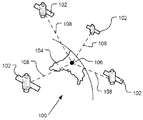
1 schematically illustrates an exemplary portion of a Global Positioning System (GPS) available by a navigation device.
2 is a schematic diagram of a communication system for communication between a navigation device and a server.
3 is a schematic view of electronic components of the navigation device or any other suitable navigation device of FIG. 2.
4 is a schematic diagram of a facility for mounting and / or docking a navigation device.
FIG. 5 is a schematic representation of a structural stack employed by the navigation device of FIG. 3.
FIG. 6 is a schematic diagram of a navigation system in which the navigation device of FIG. 3 is operably connected to the image recording device.
FIG. 7 schematically illustrates a variant of the navigation system of FIG. 6.
8 is a flow diagram illustrating one mode of operation of the systems of FIGS. 6 and 7.
이어지는 설명 동안에 동일한 참조 번호들은 유사한 부분들을 식별하기 위해서 사용될 것이다.The same reference numerals will be used to identify similar parts during the following description.
본 발명의 실시예들이 PND에 대해 특별하게 참조를 하면서 이제 설명될 것이다. 그러나, 본 발명의 교시들은 PND들로 한정되는 것이 아니며 그 대신에 경로 계획 및 내비게이션 기능을 제공하기 위해 내비게이션 소프트웨어를 실행시키도록 구성된 어떤 유형의 프로세싱 기기에도 범용으로 적용된다는 것을 기억해야만 한다. 그러므로 본 명세서의 환경에서 내비게이션 기기는, 그 기기가 PND, 차량에 장착된 내비게이션 기기 또는 실제로 경로 계획 및 내비게이션 소프트웨어를 실행하는 (데스크탑 또는 휴대용 개인용 컴퓨터 (PC), 모바일 전화기 또는 휴대용 디지털 보조 기기 (PDA)와 같은) 컴퓨팅 리소스로서 내장된 것인지의 여부에 관계없이, 임의 유형의 경로 계획 및 내비게이션 기기를 (한정하지 않으면서) 포함하도록 의도된 것이라는 것이 당연하다.Embodiments of the present invention will now be described with particular reference to PNDs. However, it should be remembered that the teachings of the present invention are not limited to PNDs, but instead are universally applicable to any type of processing device configured to execute navigation software to provide path planning and navigation functionality. Thus, in the context of the present disclosure, a navigation device may be a desktop or portable personal computer (PC), a mobile phone or a portable digital assistant (PDA) in which the device runs a PND, a vehicle-mounted navigation device or actually route planning and navigation software. Naturally, it is intended to include (but not limited to) any type of route planning and navigation device, whether or not embedded as a computing resource.
사용자가 한 지점에서 다른 지점으로 어떻게 내비게이트해야 하는가를 찾지는 않지만 주어진 위치의 뷰 (view)가 제공되기만을 원하는 경우인 환경들에서 본 발명의 교시들이 유용하다는 것이 다음의 내용으로부터 또한 명백할 것이다. 그런 환경들에서, 사용자가 선택한 "목적지" 위치는 사용자가 내비게이션을 시작하기를 원하는 대응 위치를 가질 필요는 없으며, 그래서 결과적으로 여기에서 "목적지" 위치에 대한 참조 또는 실제로 "목적지" 뷰에 대한 참조들은 경로를 생성하는 것이 본질적이며, "목적지"로 이동하는 것이 반드시 발생해야만 한다 또는 실제로 목적지의 존재는 대응하는 시작 위치의 표지를 필요로 한다는 것을 의미하는 것으로 해석되어서는 안된다.It will also be apparent from the following that the teachings of the present invention are useful in environments where the user does not find how to navigate from one point to another but only wants to provide a view of a given location. . In such environments, the user-selected "destination" location does not need to have a corresponding location where the user wants to start navigation, so consequently a reference to the "destination" location here or in fact a reference to the "destination" view. It is essential to create a route, and it must not be interpreted to mean that moving to a "destination" must occur or indeed the presence of a destination requires a marker of the corresponding starting position.
상기의 조건들을 염두에 두면서, 도 1의 글로벌 위치 파악 시스템 (GPS) 그리고 유사한 것이 다양한 목적들을 위해서 사용된다. 일반적으로, GPS는 제한되지 않은 수의 사용자들을 위한 연속적인 위치, 속도, 시간 그리고 일부 경우들에서는 방향 정보를 판별할 수 있는 위성-라디오 기반의 내비게이션 시스템이다. 이전에는 NAVSTAR로서 알려진 상기 GPS는 극도로 정밀한 궤도들로 지구를 도는 복수의 위성을 통합한다. 이런 정밀한 궤도들을 기반으로 하여, GPS 위성들은 임의 개수의 수신 유닛들에 자신의 위치를 중계할 수 있다.With the above conditions in mind, the Global Positioning System (GPS) of Figure 1 and the like are used for various purposes. In general, GPS is a satellite-radio based navigation system capable of determining continuous position, speed, time and in some cases direction information for an unlimited number of users. The GPS, formerly known as NAVSTAR, incorporates a plurality of satellites that orbit the earth in extremely precise orbits. Based on these precise orbits, GPS satellites can relay their position to any number of receiving units.
GPS 데이터를 수신하기 위해 특별하게 장착된 기기가 GPS 위성 신호들에 대한 라디오 주파수들을 스캐닝하기 시작할 때에 GPS 시스템이 구현된다. GPS 위성으로부터 라디오 신호를 수신하면, 상기 기기는 복수의 상이한 전통적인 방법들 중의 하나를 통해서 그 위성의 정확한 위치를 판별한다. 상기 기기는 적어도 3개의 서로 다른 위성 신호들을 획득할 때까지 신호들을 스캐닝하는 것을 대개의 경우들에서 계속할 것이다 (그 위치는 보통 그런 것은 아니지만, 다른 삼각측량 기술들을 이용하여 두 개의 신호들만으로 판별될 수 있다는 것에 유의한다). 기하학적인 삼각측량을 구현하여, 상기 수신기는 상기 위성들에 상대적인 자신의 2차원 위치를 결정하기 위해 이 세 개의 알려진 위치들을 활용한다. 이는 알려진 방식으로 수행될 수 있다. 추가로, 4번째의 위성 신호를 획득하는 것은 상기 수신 기기가 알려진 방식의 동일한 기하학적인 계산에 의해 자신의 3차원적인 위치를 계산할 수 있도록 할 것이다. 위치 및 속도 데이터는 제한되지 않은 수의 사용자들에 의한 연속적인 기반으로 실시간으로 업데이트될 수 있다.The GPS system is implemented when a device specially equipped to receive GPS data begins scanning radio frequencies for GPS satellite signals. Upon receiving a radio signal from a GPS satellite, the device determines the exact location of that satellite through one of a plurality of different traditional methods. The device will continue to scan the signals in most cases until at least three different satellite signals are obtained (the location is not usually, but can be determined with only two signals using other triangulation techniques). Note). By implementing geometric triangulation, the receiver utilizes these three known positions to determine its two-dimensional position relative to the satellites. This can be done in a known manner. In addition, obtaining a fourth satellite signal will enable the receiving device to calculate its three-dimensional position by the same geometric calculations in a known manner. Position and velocity data can be updated in real time on a continuous basis by an unlimited number of users.
도 1에 도시된 것과 같이, GPS 시스템 (100)은 지구 (104) 주위를 궤도 선회하는 복수의 위성들 (102)을 포함한다. GPS 수신기 (106)는 몇몇의 상기 복수의 위성들 (102)로부터 확산 스펙트럼 GPS 위성 데이터 신호들 (108)을 수신한다. 상기 확산 스펙트럼 데이터 신호들 (108)은 각 위성 (102)으로부터 계속하여 전송되며, 상기 확산 스펙트럼 데이터 신호들 (108) 각각은 데이트 스트림이 시작된 특정 위성 (102)을 식별하는 정보를 포함한다. 상기 GPS 수신기 (106)는 2차원적인 위치를 계산할 수 있도록 하기 위해서 적어도 3개의 위성들 (102)로부터의 확산 스펙트럼 데이터 신호들 (108)을 필요로 하는 것이 보통이다. 네 번째의 확산 스펙트럼 데이터 신호를 수신하면 상기 GPS 수신기 (106)가 알려진 기술을 이용하여 3차원적인 위치를 계산하는 것이 가능해진다. As shown in FIG. 1, the
도 2로 돌아가서, 상기 GPS 수신기 기기 (106)를 포함하거나 또는 그 GPS 수신기 기기에 연결된 내비게이션 기기 (200)는 디지털 연결, 예를 들면, 알려진 블루투스 기술을 경유한 데이터 연결을 설립하기 위해서 필요하다면 모바일 기기 (도시되지 않음), 예를 들면 모바일 전화기, PDA 및/또는 모바일 전화나 통신 기능을 갖춘 어떤 기기를 경유하여 "모바일" 또는 원거리 통신 네트워크의 네트워크 하드웨어와 데이터 세션을 설립할 수 있다. 그 후에, 상기 모바일 기기는 자신의 네트워크 서비스 제공자를 통해서 서버 (150)와의 네트워크 연결을 설립할 수 있다 (예를 들면 인터넷을 통해서). 그처럼, "모바일" 네트워크 연결은 상기 내비게이션 기기 (200)와 상기 서버 (150) 사이에서 설립될 수 있어서 정보용의 "실시간" 또는 적어도 아주 "최신의" 게이트웨이를 제공할 수 있다 (상기 내비게이션 기기는 그것이 단독으로 그리고/또는 차량 내에서 이동할 때에 이동성일 수 있으며 그리고 때로는 이동성이다).2, the
(서비스 제공자를 경유하여) 상기 모바일 기기와 상기 서버 (150)와 같은 다른 기기 사이에서, 예를 들면, 인터넷을 이용하여, 네트워크 연결을 설립하는 것은 알려진 방식으로 실행될 수 있다. 이런 면에서, 임의 개수의 적절한 데이터 통신 프로토콜들은, 예를 들면, TCP/IP 계층의 프로토콜을 채택할 수 있다. 또한, 상기 모바일 기기는 CDMA2000, GSM, IEEE 802.11 a/b/c/g/n 등과 같은 임의 개수의 통신 표준들을 활용할 수 있다.Establishing a network connection between the mobile device (via a service provider) and another device, such as the
그러므로, 인터넷 접속이 활용될 수 있을 것이라는 것을 알 수 있으며, 이는 모바일 전화 또는 예를 들면 상기 내비게이션 기기 (200) 내의 모바일 전화 기술을 경유한 데이터 연결을 경유하여 획득될 수 있다.Therefore, it will be appreciated that an internet connection may be utilized, which may be obtained via a mobile phone or a data connection via, for example, mobile phone technology in the
도시되지는 않았지만, 상기 내비게이션 기기 (200)는 자기 자신의 모바일 전화 기술을 자신인 내비게이션 기기 (200) 내에서 자체적으로 보유하고 있을 수 있을 것이다 (예를 들면 안테나를 포함하고 또는 옵션으로 상기 내비게이션 기기 (200)의 내부 안테나를 이용한다). 상기 내비게이션 기기 (200) 내의 모바일 전화 기술은 필요한 전화 기술 및/또는 예를 들면 안테나를 완비하면서, 내부 컴포넌트들을 포함할 수 있으며 그리고/또는 삽입 가능한 카드 (예를 들면, 가입자 신원 모듈 (Subscriber Identity Module (SIM)) 카드)를 포함할 수 있다. 그처럼, 상기 내비게이션 기기 (200) 내의 모바일 전화 기술은, 예를 들면, 인터넷을 경유하여 임의의 모바일 기기의 방식과 유사한 방식으로 상기 내비게이션 기기 (200)와 상기 서버 (150) 사이에서 네트워크 연결을 유사하게 설립할 수 있다.Although not shown, the
전화 세팅들을 위해서, 모바일 전화기 모델들, 제조사들 등의 계속 변하는 스펙트럼과 올바르게 동작하기 위해서 블루투스 기능이 있는 내비게이션 기기가 사용될 수 있으며, 모델/제조사 특정 세팅들은 예를 들면 상기 내비게이션 기기 (200) 상에 저장될 수 있을 것이다. 이런 정보를 위해서 저장된 데이터는 업데이트될 수 있다.For phone settings, a navigation device with Bluetooth function may be used to work correctly with the ever-changing spectrum of mobile phone models, manufacturers, etc., and model / manufacturer specific settings may be used on the
도 2에서, 내비게이션 시스템은 임의 개수의 상이한 설비들에 의해서 구현될 수 있는, 인터넷과 같은, 예를 들면, 광역 네트워크 (WAN)인 통신 네트워크에 의해서 지원되는 통신 채널 (152)을 경유하여, 일 실시예에서 필요하다면, 서버 (150)와 통신할 수 있는 내비게이션 장치 (200)를 포함한다. 상기 통신 채널 (152)은 상기 내비게이션 장치 (200)와 상기 서버 (150)에 연결된 전파 매체 (propagating medium) 또는 경로를 포괄적으로 나타낸다. 상기 통신 채널 (152)을 경유한 연결이 상기 서버 (150)와 상기 내비게이션 장치 (200)에서 설립되면 (그런 연결은 모바일 기기를 경유한 데이터 연결, 인터넷을 경유하여 개인용 컴퓨터를 경유한 직접 연결 등일 수 있다는 것에 주목한다), 상기 서버 (150)와 상기 내비게이션 장치 (200)는 통신할 수 있다.In FIG. 2, a navigation system is provided via a
상기 통신 채널 (152)은 특정 통신 기술로 제한되지 않는다. 추가로, 상기 통신 채널 (152)은 단일의 통신 기술로 제한되지 않는다; 즉, 상기 통신 채널 (152)은 다양한 기술을 이용하는 여러 통신 링크들을 포함할 수 있을 것이다. 예를 들면, 상기 통신 채널 (152)은 전기적인, 광학적인, 그리고/또는 전자기 통신 등을 위한 경로를 제공하도록 적응될 수 있다. 그처럼, 상기 통신 채널 (152)은 다음 것들의 하나 또는 그 이상의 결합을 포함하지만, 그것으로 제한되지는 않는다: 전기 회로들, 와이어나 동축 케이블들과 같은 전기 도체들, 광섬유 케이블들, 컨버터들, 라디오-주파수 (RF) 파형들, 대기, 자유 공간 등. 또한, 상기 통신 채널 (152)은, 예를 들면, 라우터들, 리피터들, 버퍼들, 전송기들 및 수신기들과 같은 중간의 기기들을 포함할 수 있다.The
하나의 예시적인 설비에서, 상기 통신 채널 (152)은 전화 네트워크 및 컴퓨터 네트워크에 의해서 지원된다. 또한, 상기 통신 채널 (152)은, 예를 들면, 적외선 통신, 마이크로파 주파수 통신과 같은 라디오 주파수 통신 등의 무선 통신을 조정할 수 있을 것이다. 추가로, 상기 통신 채널 (152)은 위성 통신을 조정할 수 있다.In one exemplary facility, the
상기 통신 채널 (152)을 통해서 전송된 통신 신호들은 주어진 통신 기술을 위해서 요청될 수 있거나 또는 필요할 수 있을 신호들을 포함할 수 있지만, 그것들로 제한되지는 않는다. 예를 들면, 상기 신호들은 시분할 다중 액세스 (Time Division Multiple Access (TDMA)), 주파수 분할 다중 액세스 (Frequency Division Multiple Access (FDMA)), 부호 분할 다중 액세스 (Code Division Multiple Access (CDMA)), 모바일 통신용 글로벌 시스템 (Global System for Mobile Communications (GSM)) 등과 같은 셀룰러 통신 기술에서 사용되도록 적응될 수 있을 것이다. 디지털 신호 및 아날로그 신호 두 가지 모두는 상기 통신 채널 (152)을 통해서 전송될 수 있다. 이 신호들은 상기 통신 기술을 위해서 필요할 수 있을 변조되고, 암호화되고 그리고/또는 압축된 신호들일 수 있을 것이다. The communication signals transmitted over the
상기 서버 (150)는, 도시되지 않을 수 있을 다른 컴포넌트들에 추가하여, 메모리 (156)에 동작 가능하게 연결되며 그리고 유선 또는 무선 접속 (158)을 경유하여 대용량 데이터 저장 기기 (160)에 동작 가능하게 또한 연결된 프로세서 (154)를 포함한다. 상기 대용량 저장 기기 (160)는 내비게이션 데이터와 지도 정보의 저장을 포함하고, 그리고 상기 서버 (150)와는 다른 개별 기기일 수 있으며 또는 상기 서버 (150)에 합체될 수 있다. 상기 프로세서 (154)는 상기 통신 채널 (152)을 경유하여 내비게이션 장치 (200)로부터 정보를 수신하고 그 장치로 정보를 송신하기 위해서 전송기 (162) 및 수신기 (164)에 또한 동작 가능하게 연결된다. 송신되고 그리고 수신된 상기 신호들은 데이터, 통신 및/또는 다른 전파된 신호들을 포함할 수 있을 것이다. 상기 전송기 (162) 그리고 수신기 (164)는 상기 내비게이션 시스템 (200)을 위해서 통신 설계에서 사용되는 통신 요구 사항 그리고 통신 기술에 따라서 선택되거나 또는 설계될 수 있을 것이다. 또한, 전송기 (162) 및 수신기 (164)의 기능들이 단일의 트랜시버로 결합될 수 있을 것이라는 것에 유의해야만 한다.The
상기에서 언급된 것과 같이, 상기 내비게이션 장치 (200)는, 상기 통신 채널 (152)을 통해서 신호들 그리고/또는 데이터를 송신하고 수신하기 위해서 전송기 (166) 및 수신기 (168)를 이용하여, 통신 채널 (152)을 통해서 상기 서버 (150)와 통신하도록 구성될 수 있으며, 이런 기기들은 상기 서버 (150)가 아닌 기기들, 예를 들면, 다른 서버들 (도시되지 않음)과 통신하기 위해서 또한 사용될 수 있다는 것에 주목한다. 또한, 상기 전송기 (166) 및 수신기 (168)는 통신 유닛을 구성하며 그리고 상기 내비게이션 장치 (200)를 위한 통신 설계에서 사용되는 통신 요구 사항들 및 통신 기술에 따라서 선택되거나 설계되며 그리고 상기 전송기 (166) 및 수신기 (168)의 기능들은 도 2에 관련하여 상기에서 설명된 것과 같이 단일의 트랜시버로 결합될 수 있을 것이다. 물론, 상기 내비게이션 장치 (200)는 다른 하드웨어 그리고/또는 기능적인 부분들을 포함하며, 이는 이하에서 더욱 상세하게 설명될 것이다.As mentioned above, the
서버 메모리 (156)에 저장된 소프트웨어는 상기 프로세서 (154)를 위한 명령어들을 제공하며 그리고 상기 서버 (150)가 상기 내비게이션 기기 (200)로 서비스들을 제공하도록 한다. 상기 서버 (150)에 의해 제공된 하나의 서비스는 상기 내비게이션 기기로부터의 요청들을 프로세싱하여 내비게이션 데이터를 상기 대용량 데이터 저장소 (160)로부터 상기 내비게이션 기기 (200)로 전송하는 것에 결부될 수 있을 것이다. 상기 서버에 의해서 제공될 수 있는 다른 서비스는 필요한 애플리케이션을 위해서 다양한 알고리즘들을 이용하여 상기 내비게이션 데이터를 프로세싱하고 그리고 이런 계산들의 결과들을 상기 내비게이션 기기 (200)로 송신하는 것을 포함한다. Software stored in
상기 서버 (150)는 무선 채널을 경유하여 상기 내비게이션 기기 (200)에 의해서 액세스 가능한 데이터의 원격 소스를 조직한다. 상기 서버 (150)는 로컬 영역 네트워크 (local area network (LAN)), 광역 네트워크 (wide area network (WAN)), 가상 사설망 (virtual private network (VPN)) 등에 위치한 네트워크 서버를 포함할 수 있을 것이다.The
상기 서버 (150)는 데스크 탑이나 랩탑 컴퓨터와 같은 개인용 컴퓨터를 포함할 수 있을 것이며, 그리고 상기 통신 채널 (152)은 상기 개인용 컴퓨터와 상기 내비게이션 기기 (200) 사이에서 연결된 케이블일 수 있을 것이다. 대안으로, 개인용 컴퓨터는 상기 내비게이션 기기 (200)와 상기 서버 (150) 사이에서 연결되어 상기 서버 (150)와 상기 내비게이션 기기 (200) 사이에서 인터넷 연결을 설립할 수 있을 것이다.The
상기 내비게이션 기기 (200)는 정보 다운로드를 통해서 상기 서버 (150)로부터 정보를 제공받을 수 있을 것이며, 상기 다운로드는 주기적으로 자동적으로 또는 사용자가 상기 내비게이션 기기 (200)를 상기 서버 (150)로 연결시키면 업데이트될 수 있을 것이며 그리고/또는 무선 모바일 연결 기기 및 예를 들면 TCP/IP 연결을 경유하여 상기 서버 (150)와 상기 내비게이션 기기 (200) 사이에서 만들어지는 더 일정한 또는 빈번한 연결 상에서 더욱 동적일 수 있을 것이다. 많은 동적인 계산들에 대해서, 상기 서버 (150) 내의 상기 프로세서 (154)가 많은 양의 프로세싱을 처리하기 위해서 사용될 수 있을 것이지만, 그러나, 상기 내비게이션 기기 (200)의 프로세서 (도 2에는 도시되지 않음)는 많은 프로세싱 및 계산을 또한 처리할 수 있으며, 때로는 서버 (150)와의 연결에 관계없이 그러하다.The
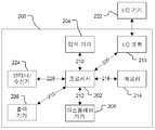
도 3을 참조하면, 상기 내비게이션 장치 (200)의 블록도는 상기 내비게이션 장치의 모든 컴포넌트들을 포함하지는 않으며, 여러 예시의 컴포넌트들의 표현만을 포함하는 것이라는 것에 유의해야만 한다. 상기 내비게이션 장치 (200)는 하우징 (도시되지 않음) 내에 위치한다. 상기 내비게이션 장치 (200)는, 예를 들면, 상기에서 언급된 프로세서 (202)를 포함하는 프로세싱 자원을 포함하며, 상기 프로세서 (202)는 입력 기기 (204) 그리고 디스플레이 기기, 예를 들면, 디스플레이 스크린 (206)에 연결된다. 비록 여기에서는 입력 기기 (204)가 단일인 것으로 참조되었지만, 본 발명이 속한 기술분야에서의 통상의 지식을 가진 자는 상기 입력 기기 (204)가 키보드 기기, 음성 입력 기기, 터치 패널 및/또는 정보를 입력하기 위해서 활용되는 어떤 다른 알려진 입력 기기를 포함하는 몇몇 개수의 입력 기기들을 나타낸다는 것을 이해하여야만 한다. Referring to FIG. 3, it should be noted that the block diagram of the
한 설비에서, 입력 기기 (204)의 한 가지 모습, 터치 패널 그리고 디스프레이 스크린 (206)은 통합되어 (직접 입력, 메뉴 선택 등을 경유한) 정보의 두 가지 입력을 가능하게 하고 그리고 터치 패널 스크린을 통한 정보 디스플레이를 가능하게 하기 위한 터치패드 또는 터치스크린 입력 (250) (도 4)을 포함하는 통합된 입력 및 디스플레이 기기를 제공하여, 사용자는 복수의 디스플레이 선택들 중의 하나를 선택하거나 또는 복수의 가장 또는 "소프트" 버튼들 중의 하나를 활성화하기 위해서 디스플레이 스크린 (206)의 부분을 터치하기만 할 필요가 있을 뿐이다. 이런 점에서, 상기 프로세서 (202)는 상기 터치스크린과 결합하여 동작하는 그래픽 사용자 인터페이스 (GUI)를 지원한다.In one installation, one aspect of the
내비게이션 장치 (200)에서, 상기 프로세서 (202)는 연결부 (210)를 경유하여 입력 기기 (204)에 동작 가능하게 연결되고 그리고 상기 입력 기기로부터 입력 정보를 수신할 수 있으며, 그리고 디스플레이 스크린 (206) 및 출력 기기 (208)의 적어도 하나에 각각의 출력 연결부들 (212)을 경유하여 동작 가능하게 연결되어 정보를 출력한다. 상기 내비게이션 장치 (200)는 출력 기기 (208), 예를 들면, 들을 수 있는 출력 기기 (예를 들면, 라우드스피커)를 포함할 수 있을 것이다. 상기 출력 기기 (208)가 상기 내비게이션 장치 (200)의 사용자를 위해서 들을 수 있는 정보를 생성할 수 있기 때문에, 입력 기기 (204)가 입력 음성 명령들을 역시 수신하기 위한 마이크로폰과 소프트웨어를 포함할 수 있다는 것이 마찬가지로 이해되어야만 한다. 또한, 상기 내비게이션 장치 (200)는, 예를 들면, 오디오 입력/출력 기기들과 같은 임의의 추가 입력 기기 (204) 및/또는 임의의 추가 출력 기기를 또한 포함할 수 있다. In
상기 프로세서 (202)는 연결부 (216)를 경유하여 메모리 자원 (214)로 동작 가능하게 연결되며 그리고 연결부 (220)를 경유하여 입력/출력 (I/O) 포트들 (218)로 정보를 송수신하도록 또한 적응되며, 이 경우 상기 I/O 포트 (218)는 상기 내비게이션 장치 (200)의 외부인 I/O 기기 (222)에 연결 가능하다. 상기 메모리 자원 (230)은, 예를 들면, 랜덤 액세스 메모리 (RAM)와 같은 휘발성 메모리 그리고 플래시 메모리와 같은 예를 들면 디지털 메모리인 비-휘발성 메모리를 포함한다. 상기 외부 I/O 기기 (222)는 예를 들면 이어피스와 같은 외부 리스닝 기기를 포함할 수 있을 것이지만, 그것으로 한정되지는 않는다. I/O 기기 (222)로의 연결은 핸즈-프리 동작을 위해서 그리고/또는 음성 구동 동작을 위해서, 예를 들면 이어피스 또는 헤드폰들로의 연결을 위해서 그리고/또는 예를 들면 모바일 전화기로의 연결을 위해서 자동차 스테레오와 같은 어떤 다른 외부 기기로의 무선의 또는 유선의 연결일 수 있으며, 그 경우 상기 내비게이션 장치 (200)와 상기 서버 (150) 사이에서의 데이터 연결을 설립하기 위해서 인터넷 또는 예를 들면 어떤 다른 네트워크를 경유하여 상기 모바일 전화기 연결이 사용될 수 있다. The
도 3은 연결부 (226)를 경유한 상기 프로세서 (202)와 안테나/수신기 (224) 사이에서의 작동적인 연결을 또한 도시하며, 이 경우에 상기 안테나/수신기 (224)는 예를 들면 GPS 안테나/수신기일 수 있다. 참조번호 224로 표시된 상기 안테나 및 수신기는 예시를 위해서 개략적으로 결합되었지만, 상기 안테나와 수신기는 개별적으로 위치한 컴포넌트들이며, 그리고 상기 안테나는 예를 들면 GPS 패치 안테나 또는 헬리칼 안테나일 수 있다는 것이 이해되어야만 한다. 3 also shows an operative connection between the
물론, 본 발명이 속한 기술 분야에서의 통상의 지식을 가진 자인 당업자는 도 3에서 도시된 전자 컴포넌트들이 하나 또는 그 이상의 전력 소스 (도시되지 않음)에 의해서 통상적인 방식으로 전력을 공급받는다는 것을 이해할 것이다. 본 발명이 속한 기술 분야에서의 통상의 지식을 가진 자가 이해하는 것처럼, 도 3에서 도시된 컴포넌트들과 상이한 구성들이 예상된다. 예를 들면, 도 3에서 도시된 컴포넌트들은 유선 그리고/또는 무선 연결들과 유사한 것을 경유하여 서로 통신할 수 있을 것이다. 그러므로, 여기에서 설명된 상기 내비게이션 장치 (200)는 휴대용 또는 핸드헬드 내비게이션 기기 (200)일 수 있다.Of course, those skilled in the art will understand that the electronic components shown in FIG. 3 are powered in a conventional manner by one or more power sources (not shown). . As will be appreciated by one of ordinary skill in the art, different configurations than the components shown in FIG. 3 are expected. For example, the components shown in FIG. 3 may be in communication with each other via similar wired and / or wireless connections. Therefore, the
추가로, 도 3의 상기 휴대용 또는 핸드헬드 내비게이션 기기 (200)는 예를 들면 자전거, 모토바이크, 자동차 또는 보트와 같은 차량으로 알려진 방식으로 연결되거나 또는 "도킹"될 수 있다. 그러면 그와 같은 내비게이션 기기는 휴대용 또는 핸드헬드 내비게이션 사용을 위해서 상기 도킹된 위치로부터 제거될 수 있다.In addition, the portable or
도 4를 참조하면, 상기 내비게이션 장치 (200)는 통합된 입력 및 디스플레이 기기 (206) 그리고 (내부 GPS 수신기 (224), 마이크로프로세서 (202), 전력 공급기 (도시되지 않음), 메모리 시스템 (214) 등을 포함하지만, 그것들로 한정되지는 않는) 도 2의 다른 컴포넌트들을 포함하는 유닛일 수 있을 것이다.4, the
상기 내비게이션 장치 (200)는 암 (252) 상에 설치될 수 있을 것이며, 상기 암은 자체적으로 흡입 컵 (254)을 이용하여 차량 대시보드/윈도우/등에 안전하게 부착될 수 있을 것이다. 이 암 (252)은 상기 내비게이션 (200)이 도킹될 수 있는 도킹 스테이션의 일 예이다. 상기 내비게이션 기기 (200)는, 예를 들면 상기 내비게이션 기기 (200)를 상기 암 (252)에 스냅 접속시켜서 도킹 스테이션의 암 (252)에 도킹될 수 있거나 그렇지 않으면 상기 암 (252)에 연결될 수 있다. 상기 내비게이션 기기 (200)는 그러면 상기 암 (292) 상에서 회전 가능할 수 있을 것이다. 상기 내비게이션 기기 (200)와 상기 도킹 스테이션 사이에서의 연결을 해제하기 위해, 예를 들면, 상기 내비게이션 기기 (200) 상의 버튼 (도시되지 않음)을 누를 수 있을 것이다. 상기 내비게이션 기기를 도킹 스테이션에 연결하고 연결을 해제하기 위한 다른 동등하게 적합한 설비들은 본 발명이 속한 기술 분야에서의 통상의 지식을 가진 자들에게는 잘 알려져 있다.The
도 5로 돌아가면, 상기 프로세서 (202)와 메모리 (214)는 상기 내비게이션 기기 (200)의 기능적인 하드웨어 컴포넌트들 (280)과 상기 기기에 의해서 실행되는 소프트웨어 사이에서의 인터페이스로서 기능하는 BIOS (Basic Input/Output System) (282)를 지원하기 위해서 협응한다. 그러면 상기 프로세서 (202)는 상기 메모리 (214)로부터 운영 시스템 (284)을 로드하며, 이는 (상기에서 설명된 경로 계획, 내비게이션 기능 중의 일부 또는 모두를 구현하는) 애플리케이션 소프트웨어 (286)가 실행될 수 있는 프로세싱 환경을 제공한다. 상기 애플리케이션 소프트웨어 (286)는 상기 내비게이션 기기의 주요 기능들, 예를 들면, 지도 보기, 경로 계획, 내비게이션 기능들 그리고 그런 것들과 연관된 다른 기능들을 지원하는 GUI를 포함하는 동작 환경을 제공한다. 이런 면에서, 상기 애플리케이션 소프트웨어 (286)의 일부는 뷰 생성 모듈 (288)을 포함한다.5, the
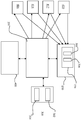
도 6은 상기 내비게이선 기기 (200)가 차량 내에 설치되고 그리고 이미지 레코딩 기기 (300)와 동작 가능하게 링크된 실시예를 보여준다. 상기 이미지 레코딩 기기 (300)는 카메라, 이 경우에는 비디오 카메라 (302) 그리고 메모리 (304)를 포함한다. 상기 실시예의 변형들에서, 상기 이미지 레코딩 기기는 상기 내비게이션 기기 (200)에 합체된다. 상기 내비게이션 기기의 다양한 컴포넌트들은 도 2 및 도 3에 도시되며, 그리고 그 컴포넌트들은 간명함을 위해서 도 6에서는 생략된 것이다.6 shows an embodiment in which the
상기 내비게이션 기기 (200)는 상기 통신 채널 (152)을 통해서 상기 서버 (150)와 통신할 수 있다. 상기 서버는 도 2에 도시된 것과 같은 프로세서 (154)를 포함하며, 그리고 그 프로세서는 사고 모니터링 모듈 (306) 그리고 비디오 데이터 프로세싱 모듈 (308)을 포함한다.The
상기 내비게이션 기기 (200)의 프로세서 (202)는 상기 비디오 레코딩 기기 (300)의 동작을 제어할 수 있다. 특히, 상기 프로세서 (202)는 기록하는 것의 시작과 중단, 상기 비디오 데이터의 저장 그리고 상기 전송기 (166)와 수신기 (168)를 이용하여 비디오 데이터를 전송하는 것을 제어할 수 있다.The
보통의 동작 과정에서, 상기 비디오 레코딩 기기는 메모리 (214) 또는 상기 기기 자체에 포함된 메모리 (304) 중의 어느 하나에 계속해서 데이터를 기록하도록 지시 받는다. 상기 메모리 (214)에는 오직 제한된 양의 기록된 비디오 데이터만이 저장되도록 할당되며, 그러므로, 이 동작 모드에서 모든 데이터는 선입/선출 (first in/first out) 기반으로 계속해서 덮어써진다.In normal operation, the video recording device is instructed to continue to record data in either
도 6의 장치는 사고, 특히 사고 발생과 같은 교통 사고에 관련한 비디오 데이터가 획득되어 프로세싱될 수 있도록 설정된다.The apparatus of FIG. 6 is set up so that video data relating to an accident, in particular a traffic accident such as an accident occurrence, can be obtained and processed.
동작의 첫 번째 모드에서, 서버 (150)에 포함된 사고 모니터링 모듈 (306)은 특정 장소에 있을 수 있는 교통 사고에 대해서 통보받는다. 상기 서버는 외부 대리인, 예를 들면, 경찰이나 교통 제어 컴퓨터에 의해서 통보를 받을 수 있을 것이며, 또는 아래에서 더 상세하게 설명되는 것과 같이 하나 또는 그 이상의 내비게이션 장치들로부터 획득된 신호를 기반으로 하여 사고가 있었음을 판별할 수 있을 것이다.In the first mode of operation, the
상기 사고의 통지에 응답하여, 상기 사고 모니터링 모듈은 사고 신호를 생성하며 그리고 내비게이션 장치 (200)가 상기 사고 근방에 있다는 것을 안다면 그 사고 신호를 상기 내비게이션 장치 (200)로 전송한다. 그 동작 모드는 내비게이션 장치들이 자신의 위치를 상기 서버 (150)에 정기적으로 전송하며 그리고 상기 서버 (150)가 상기 내비게이션 장치들의 위치를 모니터하는 경우에 특히 적용 가능하다. 상기 사고 신호는 그런 경우에 식별 대상인 장치들을 식별하는 내비게이션 장치 식별자들을 포함하며 그리고 상기 내비게이션 장치들은 상기 사고 신호에서 식별된 그런 장치들만이 상기 사고 신호에 응답하여 비디오 데이터 프로세싱 동작을 수행하도록 설정된다. In response to the notification of the accident, the accident monitoring module generates an accident signal and transmits the accident signal to the
상기 사고 신호는 상기 수신기 (168)를 경유하여 상기 내비게이션 장치에 의해서 수신되어 상기 프로세서 (202)로 전달된다. 상기 프로세서 (202)는 상기 사고 신호에 응답하여 비디오 데이터 프로세싱 동작을 개시한다. 이 예에서, 상기 비디오 데이터 프로세싱 동작은 상기 비디오 레코딩 기기로부터 상기 내비게이션 기기 (200)를 경유하여 상기 서버 (150)로 되돌아가는 비디오 데이터의 스트리밍을 포함한다.The accident signal is received by the navigation device via the
다른 예에서, 상기 프로세서는 상기 비디오 레코딩 기기에게 아직 비디오 기록을 하고 있지 않다면 비디오 기록을 시작할 것을 명령하며 또는 이미 기록한 모든 비디오 데이터를 상기 서버 (150)로 반대로 전송할 것을 상기 비디오 레코딩 기기에게 명령한다. 상기 프로세서 (202)는 상기 비디오 레코딩 기기에게 이미 기록한 비디오 데이터를 보유할 것을 또한 명령할 수 있을 것이며, 그래서 선입/선출 절차에 따른 그 비디오 데이터를 겹쳐 쓰는 것을 무시하도록 한다.In another example, the processor instructs the video recording device to start video recording if it is not already recording video or instructs the video recording device to reverse all video data already recorded to the
다른 동작 모드에서, 상기 서버는 상기 사고 신호를 범위 내의 모든 내비게이션 장치들로 전송하고 그리고 상기 사고의 위치를 식별하는 위치 식별자를 포함시킨다. 그러면 각 내비게이션 장치는 자신이 상기 사고 위치에 가까운가의 여부를 판별하고 그리고 상기 사고 신호를 그에 따라서 프로세싱한다. 보통 상기 사고 위치에서 미리 정해진 거리 내에 있는 (이 미리 정해진 거리는 상기 사고 신호에 포함되어 상기 장치들로 통보될 수 있다) 그런 내비게이션 장치들만이 상기 사고 신호에 응답하여 비디오 데이터 프로세싱 동작을 수행한다. 대안의 동작 모드에서는, 사고 신호를 수신한 모든 내비게이션 장치들이, 자신의 위치나 신원에는 관계없이, 그 사고 신호에 응답하여 비디오 데이터 프로세싱 동작을 수행한다. 그런 경우에 상기 비디오 데이터는 관련된 비디오 데이터를 선택하기 위해서 상기 서버 (150)에 의해 후처리된다.In another mode of operation, the server sends the accident signal to all navigation devices in range and includes a location identifier that identifies the location of the accident. Each navigation device then determines whether it is close to the accident location and processes the accident signal accordingly. Only such navigation devices, usually within a predetermined distance from the accident location (which may be included in the accident signal and notified to the devices), perform a video data processing operation in response to the accident signal. In an alternative mode of operation, all navigation devices that have received an accident signal perform video data processing operations in response to the accident signal, regardless of their location or identity. In that case the video data is post-processed by the
상기 프로세서 (202)는 상기 사고 신호를 수신한 것에 응답하여 비디오 데이터의 저장에 할당된 메모리 양을 또한 증가시킬 수 있을 것이며, 이는 미리 기록된 데이터가 겹치지 않도록 하는 것을 보장하기 위해서이다.The
도 7은 도 6의 내비게이션 시스템의 변형을 보여준다. 상기 내비게이션 장치 (200)는 차량 내에 설치되며 그리고 비디오 레코딩 기기 (300)에 적절하게 연결되며 그리고 상기 서버 (150)와 통신하고 있다. 이 변형에 따르면, 상기 내비게이션 장치 (200)는 상기 차량의 움직임을 탐지하는 탐지 회로 (400)에 또한 연결된다. 상기 탐지 회로 (400)는 프로세싱 회로에 링크된 가속도계를 포함한다. 상기 탐지 회로는 상기 차량의 비정상적인 움직임, 예를 들면, 갑작스러운 가속, 갑작스러운 감속, 비정상적인 회전, 미끄러짐이나 충격을 탐지하도록 구성된다. 그런 비정상적인 움직임을 탐지하면, 그것은 사고 신호를 탐지하고 그리고 그 사고 신호를 상기 내비게이션 기기 (200)의 프로세서 (202)에게 전송한다. 이 예에서, 상기 내비게이션 기기 (200)는 상기 사고 신호를 제어 신호로서 취급하도록 구성되며 그리고 상기에서 설명된 것과 같이 비디오 데이터 프로세싱 동작을 수행한다.FIG. 7 shows a variant of the navigation system of FIG. 6. The
상기 내비게이션 장치 (200)는, 상기 사고 신호를 상기 서버 (150)로 전송하는 것 대신에 또는 그에 추가하여, 상기 사고 신호를 적어도 하나의 다른 내비게이션 장치 (410, 412, 414, 416)로 직접 전송한다. 다른 내비게이션 장치들 (410, 412, 414, 416)이 적절하게 구성되어 있다면, 그것들은 상기 사고 신호에 응답하여 비디오 데이터 프로세싱 동작을 수행한다. 그래서, 차량에 탑재된 내비게이션 장치는, 상기 서버 (150)로부터 명령들을 먼저 수신할 필요도 없이, 근방에 있는 다른 차량들의 내비게이션 장치들 (410, 412, 414, 416)에게 비디오 데이터를 기록하는 것을 시작하거나 또는 비디오 데이터를 직접 전송할 것을 지시할 수 있다. 상기 내비게이션 장치들은 비디오 데이터를 상기 서버 (150)로 거꾸로 전송하기 위해서 보통은 다시 설정된다. The
다른 동작 모드에서, 상기 내비게이션 장치 (200)는 상기 사고 신호를 통신 채널 (152) 상으로 상기 전송기 (166)를 통해서 상기 서버 (150)에게로 전송한다. 상기 서버 (150)는 그 사고 신호를 수신하고 그리고 상기 내비게이션 기기 (200)의 위치에서 사고가 발생했는가를 판별한다. 그러면 상기 서버 (150)는 상기 사고 근방에 있는 다른 내비게이션 장치들에게 상기 사고 신호를 재전송하거나 또는 추가의 사고 신호를 전송하거나 또는 생성하여, 그 장치들에게 비디오 데이터 프로세싱 동작을 수행할 것을 지시한다. 그러므로, 또 다시, 비디오 데이터는 사고 근방에 있는 하나 이상의 차량으로부터 획득될 수 있을 것이다.In another mode of operation, the
사고가 발생한 것에 응답하여 하나 또는 그 이상의 내비게이션 장치들로부터 상기 서버 (150)가 수신한 비디오 데이터는 상기 비디오 데이터 프로세싱 모듈 (308)에 의해서 프로세싱된다. 가장 간단한 예에서, 상기 비디오 데이터는 그냥 저장되며 그리고 경찰, 보험 회사 또는 다른 적절한 관심이 있는 사람들에게 이용 가능하게 될 수 있을 것이다. 대안으로, 상기 비디오 데이터는 상기 서버 (150)에서 또한 편집되거나 나중에 혹은 추가로 프로세싱된다. Video data received by the
일 예에서, 상기 비디오 데이터 프로세싱 모듈 (308)은 이미지 인식 모듈, 예를 들면, 이미지 프로세싱 소프트웨어를 실행하는 차량 또는 번호판 인식 모듈을 포함한다. 상기 이미지 인식 모듈은, 차량들, 차량들의 유형들 또는 번호판들을 식별하기 위해서, 사고 근방에 있는 내비게이션 장치들로부터 수신된 비디오 데이터를 프로세싱하도록 구성된다.In one example, the video
상기 서버 (150)는 식별된 차량, 차량의 유형 또는 번호판을 나타내는 차량 식별자를 생성하고 그리고 상기 사고와 연관되어 있을 수 있을 하나 또는 그 이상의 차량들의 진행을 추적하기 위해서 상기 이미지 인식 모듈에게 상기 사건 이후에 다른 위치들로부터 수신된 비디오 데이터를 스캔할 것을 지시한다.The
다른 변형에서, 상기 이미지 인식 모듈은 상기 서버 (150) 대신에 상기 내비게이션 장치 (200)에 포함된다. 이 변형에서, 상기 내비게이션 장치 (200)는 차량, 차량의 유형 또는 번호판 자체를 식별할 수 있으며 그리고 차량 식별자를 생성할 수 있다. 상기 차량 식별자는 그러면 상기 서버 (150)로 전송될 수 있다. 그러면, 예를 들어, 다른 장소들에 있는 다른 내비게이션 장치들로부터 수신된 비디오 데이터를 프로세싱함으로써 차량을 추적하는데 있어서 상기 차량 식별자를 사용할 수 있다.In another variation, the image recognition module is included in the
상기 내비게이션 장치 (200)는 차량의 중앙 처리 유닛에 또한 링크될 수 있으며 그리고/또는 하나 또는 그 이상의 환경 또는 동작 파라미터들, 예를 들면, 광 레벨, 속도, 온도, 날씨 상태 또는 차량이나 차량 컴포넌트의 동작 중의 하나 또는 그 이상을 측정하는 차량 상의 하나 또는 그 이상의 측정 기기들에 또한 링크될 수 있다. 상기 측정 기기들이나 중앙 처리 유닛으로부터의 측정 데이터는 상기 내비게이션 기기 (200)로 송신되고 그리고 상기 비디오 데이터와 연관하여 상기 서버 (150)로 전송될 수 있을 것이다. 그러므로, 교통 사고와 같은 사고에 관련된 추가의 데이터가 획득될 수 있을 것이다.The
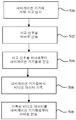
상기에서 설명된 본 발명의 실시예들의 한가지 동작 모드가 도 8의 흐름도에 도시된다.One mode of operation of the embodiments of the invention described above is shown in the flowchart of FIG. 8.
특정 위치에서 사고가 일단 발생하면, 상기에서 설명된 본 발명의 실시예들은 주변의 차량들로부터의 비디오 장면이 증거 수집을 위해서 사용되는 것을 가능하게 하기 위해서 사용될 수 있다. 사고 이후에, 상기 서버 (150)는 상기 내비게이션 기기들 (200)이 상기 비디오 데이터를 유지하고 그리고 그것을 상기 서버 (150)로 송신하도록 요청할 수 있다 그 요청은 공중 (air)을 통해서 또는 임의 유형의 연결을 통해서 상기 내비게이션 기기들로 송신될 수 있을 것이다. 상기에서 설명된 것과 같이, 근방에 있는 내비게이션 기기들이 속도에 있어서 갑작스러운 변화들과 같은 사고 특성들을 등록하기 때문에 상기 서버는 사고에 관해서 모를 수 있을 것이다.Once an accident occurs at a particular location, the embodiments of the invention described above can be used to enable video footage from surrounding vehicles to be used for evidence collection. After an accident, the
기록하는 것을 시작하라는 (또는 비디오 데이터나 다른 이미지들을 삭제하지 말라는) 호출은 다른 내비게이션 기기들로부터 올 수 있을 것이다. 상기 시스템은 상기 사고 근방에 있는 다른 번호판을 등록하도록 또한 구성될 수 있으며 그리고 상기 사고의 장면을 떠난 이후에 내비게이션 기기들이 있었던 도로 트랙 상의 모든 내비게이션 기기들을 가지도록 구성될 수 있다.A call to start recording (or not to delete video data or other images) may come from other navigation devices. The system can also be configured to register other license plates in the vicinity of the accident and can be configured to have all navigation devices on the road track where the navigation devices were after leaving the scene of the accident.
도로 사고의 근방에 있는 내비게이션 기기들은 이미 데이터를 기록하고 있을 수 있을 것이지만, 보통은 그 데이터는 특정한 시간 구간 이후에는 공간을 절약하기 위해서 폐기될 것이다. 그러나, 상기 내비게이션 기기들은 그 데이터를 유지하고 그리고 분석하기 위해서 그 데이터를 서버로 송신하라는 지시를 받을 수 있을 것이다. 이런 방식에서, 상기 사고 이전에, 사고 동안에 그리고 사고 이후로부터의 복수의 소스들로부터의 장면이 이용 가능하다. 내비게이션 기기들과 연관된 비디오 레코딩 기기들은 심지어는 도로의 다른 쪽으로부터 상기 사고 쪽으로 이동하는 반대 방향으로부터의 장면도 기록할 수 있다. 내비게이션 기기들은 어떤 다른 이용 가능한 원격 데이터 (예를 들면, 속도, 조명 조건들, 온도, CANbus 정보) 역시 기록할 수 있다. 필요하다면, 빠른 번호판 인식은 더 넓은 영역 내의 모든 기기들에게 특정 번호판을 찾고 그리고/또는 그 번호판을 마지막으로 봤을 때 또는 그 차량이 운행되던 방향을 추적하거나 기록하라고 알릴 수 있다.Navigation devices in the vicinity of road accidents may already be recording data, but usually the data will be discarded after a certain time interval to save space. However, the navigation devices may be instructed to send the data to a server to maintain and analyze the data. In this way, scenes from multiple sources before, during and after the accident are available. Video recording devices associated with navigation devices can even record scenes from opposite directions moving from the other side of the road towards the accident. Navigation devices can also record any other available remote data (eg speed, lighting conditions, temperature, CANbus information). If necessary, fast license plate recognition may inform all devices within a larger area to find a particular license plate and / or track or record the last time the license plate was viewed or the direction the vehicle was traveling.
본 발명의 다양한 모습들과 실시예들이 지금까지 설명되었지만, 본 발명의 범위는 여기에서 제시된 특정 배치들로 제한되는 것이 아니며, 첨부된 청구범위에 범위 내에 존재하는 모든 배치들, 그리고 수정 및 그에 대한 대안들을 모두 망라하도록 오히려 확대된다는 것 또한 인정될 것이다. While various aspects and embodiments of the invention have been described thus far, the scope of the invention is not limited to the specific arrangements set forth herein, but all arrangements, modifications and alternatives falling within the scope of the appended claims. It will also be appreciated that rather widening to cover all alternatives.
예를 들면, 비록 본 발명이 휴대용 내비게이션 기기로서 예시될 수 있을 것이지만, 경로 계획 및 내비게이션 기능은 적절한 소프트웨어를 동작시키는 데스크탑 또는 모바일 컴퓨팅 자원에 의해서 또한 제공될 수 있을 것이라는 것이 인정될 것이다. 예를 들면, 왕립 자동차 클럽 (Royal Automobile Club (RAC))은 온라인 경로 계획 및 내비게이션 설비를 http://www.rac.co.uk에서 제공하며, 이 설비는 사용자가 시작 포인트와 목적을 입력하면 사용자의 컴퓨팅 자원과 통신하고 있는 서버가 경로를 계산하고 (이런 모습은 사용자 특정일 수 있다), 지도를 생성하며 그리고 상기 선택된 시작 포인트로부터 선택된 목적지까지 상기 사용자를 안내하기 위한 총망라한 내비게이션 명령어들의 집합을 생성한다. For example, although the present invention may be illustrated as a portable navigation device, it will be appreciated that route planning and navigation functions may also be provided by a desktop or mobile computing resource running appropriate software. For example, the Royal Automobile Club (RAC) provides online route planning and navigation facilities at http://www.rac.co.uk, which allows users to enter a starting point and purpose. A server in communication with the user's computing resources computes a route (this may be user specific), generates a map, and generates a comprehensive set of navigation instructions for directing the user from the selected starting point to the selected destination. Create
전술한 상세한 설명에서 설명된 실시예들이 GPS를 언급했지만, 상기 내비게이션 장치는 GPS의 대안으로서 (또는 실제로는 추가해서) 어떤 유형의 위치 감지 기술도 활용할 수 있을 것이라는 것에 주목해야만 한다. 예를 들면, 상기 내비게이션 장치는 유럽의 갈릴레오 시스템과 같은 다른 글로벌 내비게이션 위성 시스템을 활용할 수 있을 것이다. 동등하게, 상기 내비게이션 장치는 위성 기반으로 한정되는 것이 아니며, 그라운드 기반 비컨 (beacon)들 또는 기기가 자신의 지리적인 위치를 판별하는 것을 가능하게 하는 어떤 다른 유형의 시스템을 이용하여 쉽게 기능할 수 있을 것이다.Although the embodiments described in the foregoing detailed description refer to GPS, it should be noted that the navigation device may utilize any type of location sensing technique as an alternative (or in fact in addition) to GPS. For example, the navigation device may utilize other global navigation satellite systems, such as the Galileo system in Europe. Equally, the navigation device is not limited to satellite based and could easily function using ground based beacons or any other type of system that enables the device to determine its geographical location. will be.
본 발명의 대안의 실시예들은 컴퓨터 시스템과 함께 사용되는 컴퓨터 프로그램 제품으로서 구현될 수 있으며, 상기 컴퓨터 프로그램 제품은, 예를 들면, 디스켓, CD-ROM, ROM 또는 고정된 디스크와 같은 유형의 데이터 기록 매체 상에 저장된 또는 컴퓨터 데이터 신호에 구체화된 일련의 컴퓨터 명령어들이며, 상기 신호는 유형의 매체 또는 무선 매체, 예를 들면, 마이크로파형이나 적외선을 통해서 전송된다. 상기 일련의 컴퓨터 명령어들은 상기에서 설명된 기능의 전부 또는 일부를 구성할 수 있으며, 그리고 반도체, 자기, 광학 또는 다른 메모리 디바이스와 같은 휘발성이나 비-휘발성의 임의 메모리 디바이스에 또한 저장될 수 있다.Alternative embodiments of the present invention may be embodied as a computer program product for use with a computer system, the computer program product being for example a type of data recording such as a diskette, CD-ROM, ROM or fixed disk. A series of computer instructions stored on a medium or embodied in a computer data signal, the signal being transmitted via tangible or wireless media, such as microwave or infrared. The series of computer instructions may constitute all or part of the functionality described above, and may also be stored in any memory device, volatile or non-volatile, such as a semiconductor, magnetic, optical or other memory device.
본 발명이 속한 기술분야에서의 통상의 지식을 가진 자는 상기 바람직한 실시예들이 소프트웨어에 의해 특정 기능을 구현하지만, 그 기능은 하드웨어 단독으로 (예를 들면, 하나 또는 그 이상의 ASIC (application specific integrated circuit)들에 의해서) 동등하게 구현될 수 있을 것이며 또는 실제로는 하드웨어와 소프트웨어의 혼합에 의해서 구현될 수 있을 것이라는 것을 또한 이해할 것이다. 그처럼, 본 발명의 범위는 소프트웨어로 구현되는 것으로만 제한되는 것으로 해석되어서는 안된다.Those skilled in the art will appreciate that the above preferred embodiments implement specific functionality by software, but the functionality is hardware alone (e.g., one or more application specific integrated circuits (ASICs). It will also be understood that they may be implemented equivalently) or in practice by a mixture of hardware and software. As such, the scope of the present invention should not be interpreted as being limited only to being implemented in software.
본 발명은 순전히 예로서 상기에서 설명되었으며, 그리고 본 발명의 범위 내에서 상세한 내용에 대한 수정들이 만들어질 수 있다는 것이 이해될 것이다. 상기의 설명에서 개시된 각 특징 그리고 (적절한 경우에는) 청구범위 및 도면들이 독립적으로 또는 어떤 적절한 결합으로 제공될 수 있을 것이다.The invention has been described above purely by way of example, and it will be understood that modifications may be made to the details within the scope of the invention. Each feature disclosed in the above description and the claims and drawings (if appropriate) may be provided independently or in any suitable combination.
Claims (16)
이미지 데이터를 기록하기 위한 이미지 레코딩 기기 (300); 및
사고가 발생한 것을 나타내는 사고 신호를 수신하도록 구성되고 그리고 그 사고 신호에 응답하여 이미지 데이터 프로세싱 동작을 수행하도록 구성된, 프로세싱 자원 (202)을 포함하는, 내비게이션 장치.As the navigation device 200, 300,
An image recording device 300 for recording image data; And
And a processing resource (202), configured to receive an incident signal indicating that an accident has occurred and configured to perform an image data processing operation in response to the accident signal.
상기 이미지 데이터 프로세싱 동작은 전송 또는 기록 동작을 포함하는, 내비게이션 장치.The method of claim 1,
And the image data processing operation comprises a transfer or write operation.
상기 전송 또는 기록 동작은 이미지 데이터를 서버 (150)로 전송하고, 이미지 데이터를 기록하고 그리고 기록된 이미지 데이터를 유지하는 것 중에서 적어도 하나를 포함하는, 내비게이션 장치.The method of claim 2,
Wherein said transmitting or recording operation comprises at least one of transferring image data to a server (150), recording the image data and maintaining the recorded image data.
상기 사고 또는 어떤 사고가 발생한 것을 탐지하며 그리고 상기 사고나 어떤 사고가 발생한 것에 응답하여 상기 사고 신호 또는 어떤 사고 신호를 생성하는 탐지 회로 (400)를 더 포함하는, 내비게이션 장치.The navigation apparatus according to any one of claims 1 to 3, wherein the navigation device comprises:
And a detection circuit (400) for detecting that the accident or any accident has occurred and generating the accident signal or any accident signal in response to the occurrence of the accident or any accident.
상기 내비게이션 장치 (200, 300)는 차량 내에 설치되고,
그리고 상기 탐지 회로 (400)는 상기 차량의 움직임을 탐지하도록 구성되고 그리고 상기 차량의 움직임에 반응하여 상기 사고 신호를 생성하도록 구성된, 내비게이션 장치.The method of claim 4, wherein
The navigation device 200, 300 is installed in a vehicle,
And the detection circuitry (400) is configured to detect movement of the vehicle and is configured to generate the accident signal in response to movement of the vehicle.
상기 사고 신호를 서버 (150)로 그리고/또는 적어도 하나의 다른 내비게이션 장치 (410, 412, 414, 416)로 전송하도록 구성된, 내비게이션 장치.The method according to claim 4 or 5, wherein the device,
And transmit the incident signal to a server (150) and / or to at least one other navigation device (410, 412, 414, 416).
상기 프로세싱 자원 (202)은 상기 사고 신호에 응답하여 추가의 데이터를 기록하고 그리고/또는 전송하도록 구성된, 내비게이션 장치.The method according to any one of claims 1 to 6,
The processing resource (202) is configured to record and / or transmit additional data in response to the incident signal.
차량 또는 번호판 인식 모듈을 더 포함하며,
상기 사고 신호는 차량 식별자를 포함하며, 그리고
상기 이미지 데이터 프로세싱 동작은 상기 차량 식별자에 종속되어 차량 또는 번호판의 존재를 위해서 상기 이미지 데이터를 분석하도록 상기 차량 또는 번호판 인식 모듈에게 명령하는 것을 포함하는, 내비게이션 장치.The navigation apparatus according to any one of claims 1 to 7, wherein the navigation device comprises:
Further comprising a vehicle or license plate recognition module,
The accident signal includes a vehicle identifier, and
And said image data processing operation instructs said vehicle or license plate recognition module to analyze said image data for the presence of a vehicle or license plate dependent on said vehicle identifier.
상기 사고 모니터링 모듈 (306)은 사고가 발생한 것에 응답하여 적어도 하나의 내비게이션 장치 (200, 300)에게 사고 신호를 전송하도록 구성되며,
상기 사고 신호는 상기 적어도 하나의 내비게이션 장치 (200, 300)에서 이미지 데이터 프로세싱을 개시하도록 하는 것인, 서버.A server 150 comprising an incident monitoring module 306,
The accident monitoring module 306 is configured to transmit an accident signal to at least one navigation device 200, 300 in response to the occurrence of the accident,
The accident signal to initiate image data processing at the at least one navigation device (200, 300).
상기 적어도 하나의 내비게이션 장치 (200, 300)로부터 이미지 데이터를 수신하도록 구성되며 그리고 상기 사고가 발생한 것에 응답하여 상기 이미지 데이터를 프로세싱하도록 구성된, 서버.The method of claim 9, wherein the server,
And receive image data from the at least one navigation device (200, 300) and process the image data in response to the accident.
차량 또는 번호판 인식 모듈을 더 포함하며,
상기 이미지 데이터를 프로세싱하는 것은 상기 사고와 연관된 적어도 하나의 차량 또는 번호판을 식별하기 위해서 상기 차량 또는 번호판 인식 모듈에 의해서 상기 이미지 데이터를 분석하는 것을 포함하는, 서버.The method of claim 10, wherein the server,
Further comprising a vehicle or license plate recognition module,
Processing the image data includes analyzing the image data by the vehicle or license plate recognition module to identify at least one vehicle or license plate associated with the accident.
상기 이미지 데이터를 프로세싱하는 것은 상기 식별된 차량 또는 번호판을 추적하기 위해서 이미지 데이터를 프로세싱하는 것을 포함하는, 서버.The method according to claim 10 or 11, wherein
Processing the image data includes processing the image data to track the identified vehicle or license plate.
상기 서버는 사고의 발생에 응답하여 사고 신호를 전송하도록 구성된 사고 모니터링 모듈 (306) 및 적어도 하나의 내비게이션 장치 (200, 300)를 포함하며,
상기 내비게이션 장치 (200, 300) 또는 각 내비게이션 장치 (200, 300)는 이미지 데이터를 기록하기 위한 이미지 레코딩 기기 (300) 및 상기 사고 신호를 수신하도록 구성되며 그리고 상기 사고 신호에 응답하여 이미지 데이터 프로세싱 동작을 수행하도록 구성된 프로세싱 자원 (202)을 포함하는, 내비게이션 시스템.A navigation system comprising a server 150,
The server includes an incident monitoring module 306 and at least one navigation device 200, 300 configured to transmit an incident signal in response to the occurrence of the incident,
The navigation device 200, 300 or each navigation device 200, 300 is configured to receive an accident signal and an image recording device 300 for recording image data and to perform an image data processing operation in response to the accident signal. And a processing resource (202) configured to perform the navigation system.
상기 사고의 장면에서 적어도 하나의 내비게이션 장치 (200, 300)를 이용하여 이미지 데이터를 기록하는 단계를 포함하는, 모니터링 방법.As a way to monitor the scene of an accident,
And recording image data using at least one navigation device (200, 300) in the scene of the accident.
상기 기록된 이미지 데이터를 상기 내비게이션 장치 (200, 300) 또는 각 내비게이션 장치 (200, 300)로부터 서버 (150)로 전송하는 단계를 더 포함하는, 모니터링 방법.The method of claim 14, wherein the method is
And transmitting the recorded image data from the navigation device (200, 300) or from each navigation device (200, 300) to a server (150).
Applications Claiming Priority (1)
| Application Number | Priority Date | Filing Date | Title |
|---|---|---|---|
| PCT/EP2008/063482 WO2010040402A1 (en) | 2008-10-08 | 2008-10-08 | Navigation apparatus and method for recording image data |
Publications (1)
| Publication Number | Publication Date |
|---|---|
| KR20110073502A true KR20110073502A (en) | 2011-06-29 |
Family
ID=40957833
Family Applications (1)
| Application Number | Title | Priority Date | Filing Date |
|---|---|---|---|
| KR1020117008041A KR20110073502A (en) | 2008-10-08 | 2008-10-08 | Navigation apparatus and method for recording image data |
Country Status (10)
| Country | Link |
|---|---|
| US (1) | US20110109737A1 (en) |
| EP (1) | EP2331910A1 (en) |
| JP (1) | JP5281165B2 (en) |
| KR (1) | KR20110073502A (en) |
| CN (1) | CN102037314A (en) |
| AU (1) | AU2008362586A1 (en) |
| BR (1) | BRPI0822738A2 (en) |
| CA (1) | CA2725562A1 (en) |
| TW (1) | TW201017113A (en) |
| WO (1) | WO2010040402A1 (en) |
Families Citing this family (20)
| Publication number | Priority date | Publication date | Assignee | Title |
|---|---|---|---|---|
| WO2009047681A1 (en) * | 2007-10-11 | 2009-04-16 | Koninklijke Philips Electronics N.V. | Method and device for processing a depth-map |
| KR20110040248A (en) * | 2009-10-13 | 2011-04-20 | 삼성전자주식회사 | Apparatus and method for reducing the energy of comsumption in digital image processing device |
| US10586227B2 (en) | 2011-02-16 | 2020-03-10 | Visa International Service Association | Snap mobile payment apparatuses, methods and systems |
| BR112013021059A2 (en) | 2011-02-16 | 2020-10-27 | Visa International Service Association | Snap mobile payment systems, methods and devices |
| US10223691B2 (en) | 2011-02-22 | 2019-03-05 | Visa International Service Association | Universal electronic payment apparatuses, methods and systems |
| WO2013006725A2 (en) | 2011-07-05 | 2013-01-10 | Visa International Service Association | Electronic wallet checkout platform apparatuses, methods and systems |
| US9582598B2 (en) | 2011-07-05 | 2017-02-28 | Visa International Service Association | Hybrid applications utilizing distributed models and views apparatuses, methods and systems |
| US9355393B2 (en) | 2011-08-18 | 2016-05-31 | Visa International Service Association | Multi-directional wallet connector apparatuses, methods and systems |
| US10825001B2 (en) | 2011-08-18 | 2020-11-03 | Visa International Service Association | Multi-directional wallet connector apparatuses, methods and systems |
| US10242358B2 (en) | 2011-08-18 | 2019-03-26 | Visa International Service Association | Remote decoupled application persistent state apparatuses, methods and systems |
| US9710807B2 (en) | 2011-08-18 | 2017-07-18 | Visa International Service Association | Third-party value added wallet features and interfaces apparatuses, methods and systems |
| US10223730B2 (en) | 2011-09-23 | 2019-03-05 | Visa International Service Association | E-wallet store injection search apparatuses, methods and systems |
| AU2013214801B2 (en) | 2012-02-02 | 2018-06-21 | Visa International Service Association | Multi-source, multi-dimensional, cross-entity, multimedia database platform apparatuses, methods and systems |
| AU2013277083A1 (en) * | 2012-02-22 | 2015-01-22 | Visa International Service Association | Intelligent consumer service terminal apparatuses, methods and systems |
| CN103278166A (en) * | 2013-04-18 | 2013-09-04 | 深圳市凯立德科技股份有限公司 | Information display method and apparatus thereof |
| US9959289B2 (en) * | 2014-08-29 | 2018-05-01 | Telenav, Inc. | Navigation system with content delivery mechanism and method of operation thereof |
| CN105654577A (en) * | 2016-03-03 | 2016-06-08 | 百度在线网络技术(北京)有限公司 | Driving navigation method and driving navigation device |
| CN109029488A (en) * | 2018-06-29 | 2018-12-18 | 百度在线网络技术(北京)有限公司 | Navigating electronic map generating method, equipment and storage medium |
| JP7400222B2 (en) * | 2019-06-14 | 2023-12-19 | マツダ株式会社 | External environment recognition device |
| US20230353636A1 (en) * | 2022-04-28 | 2023-11-02 | Rohde & Schwarz Gmbh & Co. Kg | Signal processing device, gateway, management server and method |
Family Cites Families (19)
| Publication number | Priority date | Publication date | Assignee | Title |
|---|---|---|---|---|
| GB2268608A (en) * | 1992-06-10 | 1994-01-12 | Norm Pacific Automat Corp | Vehicle accident prevention and recording system |
| US6405132B1 (en) * | 1997-10-22 | 2002-06-11 | Intelligent Technologies International, Inc. | Accident avoidance system |
| US7295925B2 (en) * | 1997-10-22 | 2007-11-13 | Intelligent Technologies International, Inc. | Accident avoidance systems and methods |
| US7426437B2 (en) * | 1997-10-22 | 2008-09-16 | Intelligent Technologies International, Inc. | Accident avoidance systems and methods |
| US20080147253A1 (en) * | 1997-10-22 | 2008-06-19 | Intelligent Technologies International, Inc. | Vehicular Anticipatory Sensor System |
| US6546119B2 (en) * | 1998-02-24 | 2003-04-08 | Redflex Traffic Systems | Automated traffic violation monitoring and reporting system |
| JP2003051095A (en) * | 2001-08-07 | 2003-02-21 | Mazda Motor Corp | Server, method and program for changing control gain of automobile |
| ITTO20020827A1 (en) * | 2002-09-20 | 2004-03-21 | Elsag Spa | SYSTEM FOR SURVEILLANCE AND / OR SECURITY CONTROL |
| KR100532919B1 (en) * | 2002-11-05 | 2005-12-02 | 기아자동차주식회사 | Information reading system of accident vehicles |
| US7409295B2 (en) * | 2004-08-09 | 2008-08-05 | M/A-Com, Inc. | Imminent-collision detection system and process |
| KR20060014765A (en) * | 2004-08-12 | 2006-02-16 | 주식회사 현대오토넷 | Emergency safety service system and method using telematics system |
| US7348895B2 (en) * | 2004-11-03 | 2008-03-25 | Lagassey Paul J | Advanced automobile accident detection, data recordation and reporting system |
| US20070032928A1 (en) * | 2005-08-08 | 2007-02-08 | Yasuo Kuwahara | Vehicle recorder to capture continuous images in the vicinity of an accident scene before and after the accident happens |
| US8125530B2 (en) * | 2006-01-13 | 2012-02-28 | Nec Corporation | Information recording system, information recording device, information recording method, and information collecting program |
| JP4743054B2 (en) * | 2006-09-06 | 2011-08-10 | 株式会社デンソー | Vehicle drive recorder |
| JP4743055B2 (en) * | 2006-09-07 | 2011-08-10 | 株式会社デンソー | Map display control device and program for map display control device |
| ATE536297T1 (en) * | 2006-10-13 | 2011-12-15 | Continental Teves Ag & Co Ohg | VEHICLE AND METHOD FOR DETERMINING VEHICLES IN THE VEHICLE SURROUNDINGS |
| WO2008134595A1 (en) * | 2007-04-27 | 2008-11-06 | Pelago, Inc. | Determining locations of interest based on user visits |
| US8570373B2 (en) * | 2007-06-08 | 2013-10-29 | Cisco Technology, Inc. | Tracking an object utilizing location information associated with a wireless device |
-
2008
- 2008-10-08 KR KR1020117008041A patent/KR20110073502A/en not_active Application Discontinuation
- 2008-10-08 EP EP08805149A patent/EP2331910A1/en not_active Withdrawn
- 2008-10-08 BR BRPI0822738-1A patent/BRPI0822738A2/en not_active IP Right Cessation
- 2008-10-08 JP JP2011530369A patent/JP5281165B2/en not_active Expired - Fee Related
- 2008-10-08 CN CN2008801292758A patent/CN102037314A/en active Pending
- 2008-10-08 WO PCT/EP2008/063482 patent/WO2010040402A1/en active Application Filing
- 2008-10-08 CA CA2725562A patent/CA2725562A1/en not_active Abandoned
- 2008-10-08 AU AU2008362586A patent/AU2008362586A1/en not_active Abandoned
- 2008-10-08 US US12/736,946 patent/US20110109737A1/en not_active Abandoned
- 2008-10-24 TW TW097141086A patent/TW201017113A/en unknown
Also Published As
| Publication number | Publication date |
|---|---|
| EP2331910A1 (en) | 2011-06-15 |
| JP5281165B2 (en) | 2013-09-04 |
| CA2725562A1 (en) | 2010-04-15 |
| AU2008362586A1 (en) | 2010-04-15 |
| JP2012505383A (en) | 2012-03-01 |
| BRPI0822738A2 (en) | 2015-06-23 |
| US20110109737A1 (en) | 2011-05-12 |
| TW201017113A (en) | 2010-05-01 |
| CN102037314A (en) | 2011-04-27 |
| WO2010040402A1 (en) | 2010-04-15 |
Similar Documents
| Publication | Publication Date | Title |
|---|---|---|
| JP5281165B2 (en) | Navigation device, server, navigation system, and method for monitoring predetermined events | |
| JP5645815B2 (en) | Apparatus, method, system and program for providing parking lot availability | |
| US20210088343A1 (en) | Methods and Systems for Generating Alternative Routes | |
| US10371533B2 (en) | Navigation device and method | |
| JP2011506983A (en) | Improved navigation device and method | |
| JP2016535277A (en) | Route generation to optimize traffic flow | |
| JP2013538403A (en) | Improvement of portable processing equipment or related improvements | |
| KR20110104473A (en) | Navigation apparatus and method | |
| WO2010040386A1 (en) | Navigation apparatus and method of determining a route therefor | |
| US9638531B2 (en) | Map matching methods for mobile devices | |
| WO2010072260A1 (en) | Navigation devices and methods for calculating an alternate route based on a response time | |
| WO2010081538A2 (en) | Navigation device & method | |
| WO2010040382A1 (en) | Navigation apparatus and method for use therein | |
| WO2009132680A1 (en) | Navigation device and method | |
| TW200930981A (en) | Improved navigation device and method | |
| WO2010072259A1 (en) | Systems and methods for providing a global response time |
Legal Events
| Date | Code | Title | Description |
|---|---|---|---|
| WITN | Application deemed withdrawn, e.g. because no request for examination was filed or no examination fee was paid |