JP6733619B2 - Positioning device - Google Patents
Positioning device Download PDFInfo
- Publication number
- JP6733619B2 JP6733619B2 JP2017133973A JP2017133973A JP6733619B2 JP 6733619 B2 JP6733619 B2 JP 6733619B2 JP 2017133973 A JP2017133973 A JP 2017133973A JP 2017133973 A JP2017133973 A JP 2017133973A JP 6733619 B2 JP6733619 B2 JP 6733619B2
- Authority
- JP
- Japan
- Prior art keywords
- positioning
- satellite
- unit
- satellites
- environment
- Prior art date
- Legal status (The legal status is an assumption and is not a legal conclusion. Google has not performed a legal analysis and makes no representation as to the accuracy of the status listed.)
- Expired - Fee Related
Links
- 238000004364 calculation method Methods 0.000 claims description 123
- 238000000034 method Methods 0.000 claims description 72
- 238000012545 processing Methods 0.000 claims description 68
- 239000006185 dispersion Substances 0.000 claims description 64
- 230000008569 process Effects 0.000 claims description 64
- 238000012217 deletion Methods 0.000 claims description 59
- 230000037430 deletion Effects 0.000 claims description 59
- 238000004891 communication Methods 0.000 claims description 46
- 238000001914 filtration Methods 0.000 claims description 27
- 230000005540 biological transmission Effects 0.000 claims description 15
- 230000002093 peripheral effect Effects 0.000 claims description 9
- 238000005070 sampling Methods 0.000 description 14
- 230000006870 function Effects 0.000 description 12
- 238000012986 modification Methods 0.000 description 12
- 230000004048 modification Effects 0.000 description 12
- 238000012937 correction Methods 0.000 description 9
- 238000010586 diagram Methods 0.000 description 9
- 238000012360 testing method Methods 0.000 description 7
- 230000004083 survival effect Effects 0.000 description 5
- 230000008859 change Effects 0.000 description 4
- 230000000694 effects Effects 0.000 description 4
- 239000005433 ionosphere Substances 0.000 description 3
- 239000005436 troposphere Substances 0.000 description 3
- 238000012351 Integrated analysis Methods 0.000 description 1
- 238000004458 analytical method Methods 0.000 description 1
- 230000001174 ascending effect Effects 0.000 description 1
- 230000003416 augmentation Effects 0.000 description 1
- 238000006243 chemical reaction Methods 0.000 description 1
- 238000010276 construction Methods 0.000 description 1
- 238000004519 manufacturing process Methods 0.000 description 1
- 230000010363 phase shift Effects 0.000 description 1
Images


Classifications
-
- G—PHYSICS
- G01—MEASURING; TESTING
- G01S—RADIO DIRECTION-FINDING; RADIO NAVIGATION; DETERMINING DISTANCE OR VELOCITY BY USE OF RADIO WAVES; LOCATING OR PRESENCE-DETECTING BY USE OF THE REFLECTION OR RERADIATION OF RADIO WAVES; ANALOGOUS ARRANGEMENTS USING OTHER WAVES
- G01S19/00—Satellite radio beacon positioning systems; Determining position, velocity or attitude using signals transmitted by such systems
- G01S19/38—Determining a navigation solution using signals transmitted by a satellite radio beacon positioning system
- G01S19/39—Determining a navigation solution using signals transmitted by a satellite radio beacon positioning system the satellite radio beacon positioning system transmitting time-stamped messages, e.g. GPS [Global Positioning System], GLONASS [Global Orbiting Navigation Satellite System] or GALILEO
- G01S19/42—Determining position
- G01S19/421—Determining position by combining or switching between position solutions or signals derived from different satellite radio beacon positioning systems; by combining or switching between position solutions or signals derived from different modes of operation in a single system
- G01S19/423—Determining position by combining or switching between position solutions or signals derived from different satellite radio beacon positioning systems; by combining or switching between position solutions or signals derived from different modes of operation in a single system by combining or switching between position solutions derived from different satellite radio beacon positioning systems
-
- G—PHYSICS
- G01—MEASURING; TESTING
- G01S—RADIO DIRECTION-FINDING; RADIO NAVIGATION; DETERMINING DISTANCE OR VELOCITY BY USE OF RADIO WAVES; LOCATING OR PRESENCE-DETECTING BY USE OF THE REFLECTION OR RERADIATION OF RADIO WAVES; ANALOGOUS ARRANGEMENTS USING OTHER WAVES
- G01S19/00—Satellite radio beacon positioning systems; Determining position, velocity or attitude using signals transmitted by such systems
- G01S19/38—Determining a navigation solution using signals transmitted by a satellite radio beacon positioning system
- G01S19/39—Determining a navigation solution using signals transmitted by a satellite radio beacon positioning system the satellite radio beacon positioning system transmitting time-stamped messages, e.g. GPS [Global Positioning System], GLONASS [Global Orbiting Navigation Satellite System] or GALILEO
- G01S19/42—Determining position
- G01S19/428—Determining position using multipath or indirect path propagation signals in position determination
-
- G—PHYSICS
- G01—MEASURING; TESTING
- G01S—RADIO DIRECTION-FINDING; RADIO NAVIGATION; DETERMINING DISTANCE OR VELOCITY BY USE OF RADIO WAVES; LOCATING OR PRESENCE-DETECTING BY USE OF THE REFLECTION OR RERADIATION OF RADIO WAVES; ANALOGOUS ARRANGEMENTS USING OTHER WAVES
- G01S19/00—Satellite radio beacon positioning systems; Determining position, velocity or attitude using signals transmitted by such systems
- G01S19/01—Satellite radio beacon positioning systems transmitting time-stamped messages, e.g. GPS [Global Positioning System], GLONASS [Global Orbiting Navigation Satellite System] or GALILEO
- G01S19/13—Receivers
- G01S19/22—Multipath-related issues
-
- G—PHYSICS
- G01—MEASURING; TESTING
- G01S—RADIO DIRECTION-FINDING; RADIO NAVIGATION; DETERMINING DISTANCE OR VELOCITY BY USE OF RADIO WAVES; LOCATING OR PRESENCE-DETECTING BY USE OF THE REFLECTION OR RERADIATION OF RADIO WAVES; ANALOGOUS ARRANGEMENTS USING OTHER WAVES
- G01S19/00—Satellite radio beacon positioning systems; Determining position, velocity or attitude using signals transmitted by such systems
- G01S19/01—Satellite radio beacon positioning systems transmitting time-stamped messages, e.g. GPS [Global Positioning System], GLONASS [Global Orbiting Navigation Satellite System] or GALILEO
- G01S19/13—Receivers
- G01S19/24—Acquisition or tracking or demodulation of signals transmitted by the system
- G01S19/28—Satellite selection
-
- G—PHYSICS
- G01—MEASURING; TESTING
- G01S—RADIO DIRECTION-FINDING; RADIO NAVIGATION; DETERMINING DISTANCE OR VELOCITY BY USE OF RADIO WAVES; LOCATING OR PRESENCE-DETECTING BY USE OF THE REFLECTION OR RERADIATION OF RADIO WAVES; ANALOGOUS ARRANGEMENTS USING OTHER WAVES
- G01S19/00—Satellite radio beacon positioning systems; Determining position, velocity or attitude using signals transmitted by such systems
- G01S19/01—Satellite radio beacon positioning systems transmitting time-stamped messages, e.g. GPS [Global Positioning System], GLONASS [Global Orbiting Navigation Satellite System] or GALILEO
- G01S19/13—Receivers
- G01S19/33—Multimode operation in different systems which transmit time stamped messages, e.g. GPS/GLONASS
-
- G—PHYSICS
- G01—MEASURING; TESTING
- G01S—RADIO DIRECTION-FINDING; RADIO NAVIGATION; DETERMINING DISTANCE OR VELOCITY BY USE OF RADIO WAVES; LOCATING OR PRESENCE-DETECTING BY USE OF THE REFLECTION OR RERADIATION OF RADIO WAVES; ANALOGOUS ARRANGEMENTS USING OTHER WAVES
- G01S19/00—Satellite radio beacon positioning systems; Determining position, velocity or attitude using signals transmitted by such systems
- G01S19/38—Determining a navigation solution using signals transmitted by a satellite radio beacon positioning system
- G01S19/39—Determining a navigation solution using signals transmitted by a satellite radio beacon positioning system the satellite radio beacon positioning system transmitting time-stamped messages, e.g. GPS [Global Positioning System], GLONASS [Global Orbiting Navigation Satellite System] or GALILEO
- G01S19/42—Determining position
-
- G—PHYSICS
- G01—MEASURING; TESTING
- G01S—RADIO DIRECTION-FINDING; RADIO NAVIGATION; DETERMINING DISTANCE OR VELOCITY BY USE OF RADIO WAVES; LOCATING OR PRESENCE-DETECTING BY USE OF THE REFLECTION OR RERADIATION OF RADIO WAVES; ANALOGOUS ARRANGEMENTS USING OTHER WAVES
- G01S5/00—Position-fixing by co-ordinating two or more direction or position line determinations; Position-fixing by co-ordinating two or more distance determinations
- G01S5/01—Determining conditions which influence positioning, e.g. radio environment, state of motion or energy consumption
- G01S5/011—Identifying the radio environment
-
- G—PHYSICS
- G01—MEASURING; TESTING
- G01S—RADIO DIRECTION-FINDING; RADIO NAVIGATION; DETERMINING DISTANCE OR VELOCITY BY USE OF RADIO WAVES; LOCATING OR PRESENCE-DETECTING BY USE OF THE REFLECTION OR RERADIATION OF RADIO WAVES; ANALOGOUS ARRANGEMENTS USING OTHER WAVES
- G01S19/00—Satellite radio beacon positioning systems; Determining position, velocity or attitude using signals transmitted by such systems
- G01S19/01—Satellite radio beacon positioning systems transmitting time-stamped messages, e.g. GPS [Global Positioning System], GLONASS [Global Orbiting Navigation Satellite System] or GALILEO
- G01S19/13—Receivers
- G01S19/24—Acquisition or tracking or demodulation of signals transmitted by the system
- G01S19/25—Acquisition or tracking or demodulation of signals transmitted by the system involving aiding data received from a cooperating element, e.g. assisted GPS
- G01S19/254—Acquisition or tracking or demodulation of signals transmitted by the system involving aiding data received from a cooperating element, e.g. assisted GPS relating to Doppler shift of satellite signals
-
- G—PHYSICS
- G01—MEASURING; TESTING
- G01S—RADIO DIRECTION-FINDING; RADIO NAVIGATION; DETERMINING DISTANCE OR VELOCITY BY USE OF RADIO WAVES; LOCATING OR PRESENCE-DETECTING BY USE OF THE REFLECTION OR RERADIATION OF RADIO WAVES; ANALOGOUS ARRANGEMENTS USING OTHER WAVES
- G01S19/00—Satellite radio beacon positioning systems; Determining position, velocity or attitude using signals transmitted by such systems
- G01S19/38—Determining a navigation solution using signals transmitted by a satellite radio beacon positioning system
- G01S19/39—Determining a navigation solution using signals transmitted by a satellite radio beacon positioning system the satellite radio beacon positioning system transmitting time-stamped messages, e.g. GPS [Global Positioning System], GLONASS [Global Orbiting Navigation Satellite System] or GALILEO
- G01S19/42—Determining position
- G01S19/51—Relative positioning
Description
本開示は、測位衛星から送信される測位信号を用いて測位を行う測位装置に関する。 The present disclosure relates to a positioning device that performs positioning using a positioning signal transmitted from a positioning satellite.
従来、特許文献1に開示されているように、全球測位衛星システム(GNSS:Global Navigation Satellite System)を構成する複数の測位衛星から送信される測位信号を用いて測位演算処理を行う装置(つまり測位装置)が知られている。測位装置は、測位信号を捕捉できている全ての測位衛星についての観測データ(例えば擬似距離等)を用いて測位演算処理を実施するように構成されていることが多い。測位演算処理に用いる測位衛星の数は多いほど、測位精度の向上が期待できるためである。
Conventionally, as disclosed in
また、近年は、測位演算処理に利用可能な測位衛星の数を増やすために、測位装置の中には、それぞれ提供者が異なる複数のGNSSの測位信号を併用して現在位置を算出する装置も開発されつつある。例えば、米国のGPS(Global Positioning System)を構成する測位衛星から送信される測位信号と、ロシアのGLONASSを構成する測位衛星から送信される測位信号の両方を用いて測位演算処理を実施する装置(以降、マルチGNSS測位装置)も提案及び開発されている。なお、GNSSに該当するシステムとしては、米国のGPS、GLONASSの他に、例えば欧州のGalileo、中国のBeiDouなどが存在する。 In addition, in recent years, in order to increase the number of positioning satellites that can be used for positioning calculation processing, some positioning devices also use a combination of positioning signals of a plurality of GNSSs from different providers to calculate the current position. It is being developed. For example, a device that performs positioning calculation processing using both a positioning signal transmitted from a positioning satellite forming a GPS (Global Positioning System) in the United States and a positioning signal transmitted from a positioning satellite forming a GLONASS in Russia ( Since then, a multi-GNSS positioning device) has also been proposed and developed. In addition to GPS and GLONASS in the United States, for example, Galileo in Europe and BeiDou in China exist as systems corresponding to GNSS.
また、測位衛星を用いたシステムとしては、特定の地域をサービスの提供対象とした、地域航法衛星システム(いわゆるRNSS:Regional Navigation Satellite System)も実用化されつつある。便宜上、GNSSとRNSSとを区別しない場合には測位システムと記載する。 In addition, as a system using positioning satellites, a regional navigation satellite system (RNSS: So-called RNSS), which provides a service to a specific area, is being put to practical use. For convenience, when the GNSS and the RNSS are not distinguished from each other, they are described as a positioning system.
GNSSの測位精度は、システム毎に地域性がある。例えばGPSは、米国を中心とするシステムであるため、北半球での測位精度を優先すべく、各測位衛星の軌道として、北半球側での高度が南半球側での高度よりも相対的に高くなる楕円軌道が採用されている。その結果、北半球では仰角が大きい測位衛星を捕捉しやすくなるため、北半球の測位精度は、南半球での測位精度よりも良い傾向を備える。 The positioning accuracy of GNSS varies from system to system. For example, since GPS is a system centered on the United States, in order to prioritize positioning accuracy in the northern hemisphere, an ellipse in which the altitude of the northern hemisphere is relatively higher than that of the southern hemisphere is used as the orbit of each positioning satellite. Orbit is adopted. As a result, it becomes easier to capture positioning satellites with a large elevation angle in the northern hemisphere, and thus the positioning accuracy in the northern hemisphere tends to be better than that in the southern hemisphere.
同様に、他の測位システムも、当該システムを構成する測位衛星の軌道に応じて、相対的に高い精度が得られる地域と、相対的に精度が劣化する地域がある。換言すれば、測位システム毎に、得意な地域と不得手な地域とが存在する。なお、特別に不得手な地域が存在しない代わりに、得意な地域も存在せず、全体的な精度がそこまで良くない測位システムも想定される。 Similarly, in other positioning systems, there are areas where relatively high accuracy is obtained and areas where accuracy is relatively degraded according to the orbits of the positioning satellites that compose the system. In other words, for each positioning system, there are areas that are good and areas that are weak. It should be noted that a positioning system is also assumed in which there are no special weak areas, but there are no good areas, and the overall accuracy is not so good.
なお、測位システムの測位精度は、当然、周辺環境によっても異なる。マルチパス環境下では測位システムの本来の(換言すれば最大限の)測位精度は発揮されにくい。ここで言及している測位システムの精度とは、例えばオープンスカイ環境下など、測位システムの本来の測位精度が発揮される環境下での平均的な測位精度である。 The positioning accuracy of the positioning system naturally varies depending on the surrounding environment. In a multipath environment, the positioning system's original (in other words, maximum positioning accuracy) is difficult to exert. The accuracy of the positioning system referred to here is an average positioning accuracy in an environment where the original positioning accuracy of the positioning system is exhibited, such as in an open sky environment.
そのような事情を鑑みると、マルチGNSS測位装置が対応している測位システムの中にも、マルチGNSS測位装置が使用されている地域に応じて精度の優劣が発生し、相対的に精度がよい測位結果を得られやすい測位システム(以降、第1システム)と、第1システムに比べると精度が劣る測位システムである第2システムとが存在することになる。例えば北米エリアではGPSはbeiduよりも精度がよい測位結果が得られやすい。一方、東南アジアではGPSの精度は相対的に低く、beiduは相対的に精度がよい測位結果を提供する。 In view of such a situation, even in the positioning system supported by the multi-GNSS positioning device, superiority or inferiority of accuracy occurs depending on the area where the multi-GNSS positioning device is used, and the accuracy is relatively good. This means that there are a positioning system (hereinafter, the first system) that can easily obtain the positioning result and a second system that is a positioning system that is less accurate than the first system. For example, in the North American area, GPS is likely to obtain positioning results with higher accuracy than beidu. On the other hand, in Southeast Asia, GPS accuracy is relatively low, and beidu provides relatively accurate positioning results.
発明者らは種々の試験をした結果、例えばオープンスカイのような第1システムに属する測位衛星を十分に捕捉できている状況において、相対的に誤差が大きい第2システムの測位衛星についての観測データも測位演算処理に使用すると、測位精度が低下する場合があるという知見を得た。 As a result of various tests conducted by the inventors, in a situation where a positioning satellite belonging to the first system, such as Open Sky, can be sufficiently captured, observation data of the positioning satellite of the second system having a relatively large error is obtained. It was found that the positioning accuracy may be reduced if the same is used for positioning calculation processing.
本開示は、この事情に基づいて成されたものであり、その目的とするところは、複数のGNSSの測位信号を組み合わせて用いて測位演算処理を実行可能な測位装置であって、より精度が良い測位結果を出力可能な測位装置を提供することにある。 The present disclosure has been made based on this situation, and an object of the present disclosure is a positioning device capable of executing positioning calculation processing using a combination of positioning signals of a plurality of GNSSs, and more accurate. It is to provide a positioning device capable of outputting a good positioning result.
その目的を達成するための本開示の第1の測位装置は、複数の測位システムの測位信号を組み合わせて測位演算処理を実行可能な測位装置であって、複数の測位システムのそれぞれが備える複数の測位衛星から送信される測位信号を受信する信号受信部(11)と、信号受信部が受信した測位信号に基づいて、受信した測位信号の送信元としての測位衛星についてのドップラーシフト量及び擬似距離の少なくとも何れか一方を、マルチパス環境下であるか否かを判定するための指標値として逐次算出する指標値算出部(12)と、信号受信部で測位信号を受信できている測位衛星である捕捉衛星毎に、その捕捉衛星に対して指標値算出部が算出した指標値のばらつき度合いを示す指標値散布度を算出する散布度算出部(13)と、散布度算出部が算出した捕捉衛星毎の指標値散布度に基づいて、複数の捕捉衛星のうち、測位演算処理に使用しない捕捉衛星である不使用衛星を決定する衛星選択部(15)と、捕捉衛星の総数に対する衛星選択部によって不使用衛星に設定された捕捉衛星の数の比である削除率に基づいて、周辺環境はマルチパスが発生しやすい環境であるか否かを判定する環境判定部(16)と、を備え、環境判定部の判定結果に応じて、複数の測位システムのうち、測位演算処理に使用する測位システムである使用システムを少なくとも1つ選択するシステム選択部(17)と、衛星選択部によって不使用衛星に設定されなかった捕捉衛星である残存衛星のなかで、システム選択部によって使用システムとして選択された測位システムが備える測位衛星からの測位信号を用いて測位演算処理を実施する測位演算部(18)と、測位装置が対応している複数の測位システムの平均的な測位精度の順位を示すデータが登録されているシステムランク記憶部(M1)とを備え、システム選択部は、環境判定部が削除率に基づき周辺環境はマルチパスが発生しやすい環境ではないと判定している場合には、複数の測位システムのうち、システムランク記憶部において測位精度が最も低い測位システムとして登録されている低精度システムは使用システムには設定せず、測位演算部は、低精度システムに属する測位衛星からの測位信号は測位演算処理に用いず、環境判定部は、マルチパスの発生のしやすさに応じて段階的に予め設定されている複数のカテゴリのうちの何れに周辺環境は該当するかを削除率に基づいて判定するものであって、複数のカテゴリには、少なくとも、マルチパスが最も発生しにくいオープンスカイ環境に相当するカテゴリであるオープンスカイカテゴリと、マルチパスが最も発生しやすい都市部に相当するカテゴリである都市部カテゴリとが含まれており、システム選択部は、環境判定部によって判定された周辺環境がよりマルチパスの発生しやすいカテゴリであるほど、使用システムとして選択する測位システムの数を増やすように構成されていることを特徴とする。
また、その目的を達成するための本開示の第2の測位装置は、複数の測位システムの測位信号を組み合わせて測位演算処理を実行可能な測位装置であって、複数の測位システムのそれぞれが備える複数の測位衛星から送信される測位信号を受信する信号受信部(11)と、信号受信部が受信した測位信号に基づいて、受信した測位信号の送信元としての測位衛星についてのドップラーシフト量及び擬似距離の少なくとも何れか一方を、マルチパス環境下であるか否かを判定するための指標値として逐次算出する指標値算出部(12)と、信号受信部で測位信号を受信できている測位衛星である捕捉衛星毎に、その捕捉衛星に対して指標値算出部が算出した指標値のばらつき度合いを示す指標値散布度を算出する散布度算出部(13)と、散布度算出部が算出した捕捉衛星毎の指標値散布度に基づいて、複数の捕捉衛星のうち、測位演算処理に使用しない捕捉衛星である不使用衛星を決定する衛星選択部(15)と、捕捉衛星の総数に対する衛星選択部によって不使用衛星に設定された捕捉衛星の数の比である削除率に基づいて、周辺環境はマルチパスが発生しやすい環境であるか否かを判定する環境判定部(16)と、を備え、環境判定部の判定結果に応じて、複数の測位システムのうち、測位演算処理に使用する測位システムである使用システムを少なくとも1つ選択するシステム選択部(17)と、衛星選択部によって不使用衛星に設定されなかった捕捉衛星である残存衛星のなかで、システム選択部によって使用システムとして選択された測位システムが備える測位衛星からの測位信号を用いて測位演算処理を実施する測位演算部(18)と、測位装置が対応している複数の測位システムの平均的な測位精度の順位を示すデータが登録されているシステムランク記憶部(M1)とを備え、システム選択部は、環境判定部が削除率に基づき周辺環境はマルチパスが発生しやすい環境ではないと判定している場合には、複数の測位システムのうち、システムランク記憶部において測位精度が最も低い測位システムとして登録されている低精度システムは使用システムには設定せず、測位演算部は、低精度システムに属する測位衛星からの測位信号は測位演算処理に用いず、衛星選択部による不使用衛星を選択する処理であるフィルタリング処理の結果としての、過去一定回数のフィルタリング処理の結果として残った観測データに対応する捕捉衛星の衛星番号、又は、過去一定回数のフィルタリング処理によって削除された観測データに対応する捕捉衛星の衛星番号に基づいて、複数の測位システムの中で測位精度が最も高い測位システムを特定し、当該測位システムを、複数の測位システムの中で測位精度が最も高い測位システムである高精度システムとしてシステムランク記憶部に登録する高精度システム特定部(191)を備えることを特徴とする。
また、その目的を達成するための本開示の第3の測位装置は、複数の測位システムの測位信号を組み合わせて測位演算処理を実行可能な測位装置であって、複数の測位システムのそれぞれが備える複数の測位衛星から送信される測位信号を受信する信号受信部(11)と、信号受信部が受信した測位信号に基づいて、受信した測位信号の送信元としての測位衛星についてのドップラーシフト量及び擬似距離の少なくとも何れか一方を、マルチパス環境下であるか否かを判定するための指標値として逐次算出する指標値算出部(12)と、信号受信部で測位信号を受信できている測位衛星である捕捉衛星毎に、その捕捉衛星に対して指標値算出部が算出した指標値のばらつき度合いを示す指標値散布度を算出する散布度算出部(13)と、散布度算出部が算出した捕捉衛星毎の指標値散布度に基づいて、複数の捕捉衛星のうち、測位演算処理に使用しない捕捉衛星である不使用衛星を決定する衛星選択部(15)と、捕捉衛星の総数に対する衛星選択部によって不使用衛星に設定された捕捉衛星の数の比である削除率に基づいて、周辺環境はマルチパスが発生しやすい環境であるか否かを判定する環境判定部(16)と、を備え、環境判定部の判定結果に応じて、複数の測位システムのうち、測位演算処理に使用する測位システムである使用システムを少なくとも1つ選択するシステム選択部(17)と、衛星選択部によって不使用衛星に設定されなかった捕捉衛星である残存衛星のなかで、システム選択部によって使用システムとして選択された測位システムが備える測位衛星からの測位信号を用いて測位演算処理を実施する測位演算部(18)と、測位装置が対応している複数の測位システムの平均的な測位精度の順位を示すデータが登録されているシステムランク記憶部(M1)とを備え、システム選択部は、環境判定部が削除率に基づき周辺環境はマルチパスが発生しやすい環境ではないと判定している場合には、複数の測位システムのうち、システムランク記憶部において測位精度が最も低い測位システムとして登録されている低精度システムは使用システムには設定せず、測位演算部は、低精度システムに属する測位衛星からの測位信号は測位演算処理に用いず、衛星選択部による不使用衛星を選択する処理であるフィルタリング処理の結果としての、過去一定回数のフィルタリング処理の結果として残った観測データに対応する捕捉衛星の衛星番号、又は、過去一定回数のフィルタリング処理によって削除された観測データに対応する捕捉衛星の衛星番号に基づいて、複数の測位システムの中で測位精度が最も低い測位システムを特定し、当該測位システムを低精度システムとしてシステムランク記憶部に登録する低精度システム特定部(192)を備えることを特徴とする。
A first positioning device of the present disclosure for achieving the object is a positioning device capable of executing positioning calculation processing by combining positioning signals of a plurality of positioning systems, and a plurality of positioning devices provided in each of the plurality of positioning systems. A signal receiving unit (11) that receives a positioning signal transmitted from a positioning satellite, and a Doppler shift amount and a pseudo distance for the positioning satellite as the transmission source of the received positioning signal based on the positioning signal received by the signal receiving unit. An index value calculation unit (12) that sequentially calculates at least one of the above as an index value for determining whether or not a multipath environment is present, and a positioning satellite that can receive a positioning signal by the signal reception unit. For each acquisition satellite, a dispersion degree calculation unit (13) for calculating an index value dispersion degree indicating the degree of dispersion of the index value calculated by the index value calculation unit for the acquisition satellite, and the capture calculated by the dispersion degree calculation unit A satellite selection unit (15) that determines an unused satellite, which is an acquisition satellite that is not used for positioning calculation processing, among a plurality of acquisition satellites based on the index value dispersion degree of each satellite, and a satellite selection unit for the total number of acquisition satellites. An environment determination unit (16) that determines whether or not the surrounding environment is an environment in which multipath is likely to occur, based on the deletion rate, which is the ratio of the number of captured satellites set to unused satellites by A system selection unit (17) that selects at least one used system that is a positioning system to be used for positioning calculation processing among a plurality of positioning systems according to the determination result of the environment determination unit, and is not used by the satellite selection unit. A positioning calculation unit (18) that performs a positioning calculation process using a positioning signal from a positioning satellite included in the positioning system selected as the system to be used by the system selection unit among the remaining satellites that are not set as satellites ) And a system rank storage unit (M1) in which data indicating an average positioning accuracy order of a plurality of positioning systems supported by the positioning device is registered, and the system selection unit includes an environment determination unit. If it is determined that the surrounding environment is not an environment in which multipath is likely to occur based on the deletion rate, the low positioning system registered as the positioning system with the lowest positioning accuracy in the system rank storage unit among the multiple positioning systems The accuracy system is not set as the system to be used, the positioning calculation unit does not use the positioning signals from the positioning satellites belonging to the low accuracy system for the positioning calculation process, and the environment determination unit determines whether the multipath is likely to occur. Based on the deletion rate, which of the multiple categories preset in stages It is to be judged that there are at least the open sky category which is the category corresponding to the open sky environment where the multipath is the least likely to occur and the category which corresponds to the urban area where the multipath is most likely to occur. A certain urban area category is included, and the system selection unit increases the number of positioning systems to be selected as the use system as the surrounding environment determined by the environment determination unit is a category in which multipath is more likely to occur. It is characterized in that it is configured .
A second positioning device of the present disclosure for achieving the object is a positioning device capable of executing positioning calculation processing by combining positioning signals of a plurality of positioning systems, and each of the plurality of positioning systems includes. A signal receiving unit (11) for receiving positioning signals transmitted from a plurality of positioning satellites, and a Doppler shift amount for the positioning satellite as a transmission source of the received positioning signals based on the positioning signals received by the signal receiving unit and An index value calculation unit (12) that sequentially calculates at least one of the pseudo distances as an index value for determining whether or not the multipath environment is present, and a positioning that can receive a positioning signal by the signal reception unit. For each captured satellite that is a satellite, a dispersion degree calculation unit (13) that calculates an index value dispersion degree that indicates the degree of dispersion of the index values calculated by the index value calculation unit for that acquisition satellite, and a dispersion degree calculation unit A satellite selection unit (15) that determines an unused satellite that is a capture satellite that is not used for positioning calculation processing among a plurality of capture satellites based on the index value dispersion degree of each captured satellite, and a satellite with respect to the total number of capture satellites. An environment determination unit (16) that determines whether or not the surrounding environment is an environment in which multipath is likely to occur, based on the deletion rate, which is the ratio of the number of captured satellites set to unused satellites by the selection unit, A system selecting unit (17) for selecting at least one used system, which is a positioning system used for positioning calculation processing, among a plurality of positioning systems according to the determination result of the environment determining unit; A positioning calculation unit that performs positioning calculation processing using the positioning signal from the positioning satellite included in the positioning system selected as the system to be used by the system selection unit among the remaining satellites that are acquisition satellites that have not been set as unused satellites. (18) and a system rank storage unit (M1) in which data indicating an average positioning accuracy ranking of a plurality of positioning systems supported by the positioning device is registered, and the system selection unit is configured to determine the environment. If the department determines that the surrounding environment is not an environment where multipath is likely to occur based on the deletion rate, it is registered as the positioning system with the lowest positioning accuracy in the system rank storage unit among the multiple positioning systems. The low-precision system is not set as the used system, and the positioning calculation unit does not use the positioning signals from the positioning satellites belonging to the low-precision system for the positioning calculation process, but the satellite selection unit selects an unused satellite. Observations left as a result of a certain number of past filtering processes as a result of the filtering process The positioning system with the highest positioning accuracy among a plurality of positioning systems based on the satellite number of the acquisition satellite corresponding to the data or the satellite number of the acquisition satellite corresponding to the observation data deleted by a certain number of past filtering processes. And a high-precision system identification unit (191) for registering the positioning system in the system rank storage unit as a high-precision system that is the positioning system with the highest positioning accuracy among the plurality of positioning systems. To do.
A third positioning device of the present disclosure for achieving the object is a positioning device capable of executing positioning calculation processing by combining positioning signals of a plurality of positioning systems, and each of the plurality of positioning systems includes. A signal receiving unit (11) for receiving positioning signals transmitted from a plurality of positioning satellites, and a Doppler shift amount for the positioning satellite as a transmission source of the received positioning signals based on the positioning signals received by the signal receiving unit and An index value calculation unit (12) that sequentially calculates at least one of the pseudo distances as an index value for determining whether or not the multipath environment is present, and a positioning that can receive a positioning signal by the signal reception unit. For each captured satellite that is a satellite, a dispersion degree calculation unit (13) that calculates an index value dispersion degree that indicates the degree of dispersion of the index values calculated by the index value calculation unit for the captured satellite, and a dispersion degree calculation unit A satellite selection unit (15) that determines an unused satellite that is a capture satellite that is not used for positioning calculation processing among a plurality of capture satellites based on the index value dispersion degree of each captured satellite, and a satellite with respect to the total number of capture satellites. An environment determination unit (16) that determines whether or not the surrounding environment is an environment in which multipath is likely to occur, based on the deletion rate, which is the ratio of the number of captured satellites set to unused satellites by the selection unit, A system selecting unit (17) for selecting at least one used system, which is a positioning system used for positioning calculation processing, among a plurality of positioning systems according to the determination result of the environment determining unit; A positioning calculation unit that performs positioning calculation processing using the positioning signal from the positioning satellite included in the positioning system selected as the system to be used by the system selection unit among the remaining satellites that are acquisition satellites that have not been set as unused satellites. (18) and a system rank storage unit (M1) in which data indicating an average positioning accuracy ranking of a plurality of positioning systems supported by the positioning device is registered, and the system selection unit is configured to determine the environment. If the department determines that the surrounding environment is not an environment where multipath is likely to occur based on the deletion rate, it is registered as the positioning system with the lowest positioning accuracy in the system rank storage unit among the multiple positioning systems. The low-precision system is not set as the used system, and the positioning calculation unit does not use the positioning signals from the positioning satellites belonging to the low-precision system for the positioning calculation process, but the satellite selection unit selects an unused satellite. Observations left as a result of a certain number of past filtering processes as a result of the filtering process The positioning system with the lowest positioning accuracy among a plurality of positioning systems based on the satellite number of the acquisition satellite corresponding to the data or the satellite number of the acquisition satellite corresponding to the observation data deleted by a certain number of past filtering processes. Is specified, and the positioning system is provided as a low accuracy system, and a low accuracy system identification unit (192) is registered in the system rank storage unit.
上記の構成によれば、常に測位装置が対応している全ての測位システムを使うわけではない。環境判定部が判定した周辺環境に応じて、測位演算処理に用いる測位システムを取捨選択する。よって、例えばオープンスカイ環境下など、測位装置が対応している測位システムのうち、相対的に測位精度が劣る測位システムに属する測位衛星から測位信号を測位演算処理に用いることによって最終的な測位精度が劣化してしまう環境においては、当該測位システムを測位演算処理に使用しないといった制御態様を採用することができる。つまり、上記の構成によれば、より精度が良い測位結果を出力となる。 According to the above configuration, not all positioning systems supported by the positioning device are always used. The positioning system used for the positioning calculation process is selected according to the surrounding environment determined by the environment determination unit. Therefore, by using the positioning signal from the positioning satellite belonging to the positioning system with relatively low positioning accuracy among the positioning systems supported by the positioning device, such as in the open sky environment, for the final positioning accuracy. In an environment where is deteriorated, it is possible to adopt a control mode in which the positioning system is not used for positioning calculation processing. That is, according to the above configuration, a more accurate positioning result is output.
なお、特許請求の範囲に記載した括弧内の符号は、一つの態様として後述する実施形態に記載の具体的手段との対応関係を示すものであって、本開示の技術的範囲を限定するものではない。 It should be noted that the reference numerals in parentheses described in the claims indicate the correspondence with the specific means described in the embodiments described below as one aspect, and limit the technical scope of the present disclosure. is not.
[実施形態]
本開示の実施形態としての測位装置1について図を用いて説明する。図1は、測位装置1を含むシステム全体の概略的な構成の一例を示す図である。測位装置1は、概略的に、複数の測位衛星2〜5、及び準天頂衛星6のそれぞれから送信される測位信号を受信することによって現在位置を逐次する装置である。測位装置1は、車両Hvに搭載されており、測位装置1の測位結果(つまり現在位置情報)は、例えば自動運転や経路案内等といった任意のアプリケーションソフトウェアで利用される。
[Embodiment]
A
なお、車両Hvは、四輪自動車であってもよいし、二輪自動車や、三輪自動車等であってもよい。二輪自動車には原動機付き自転車も含まれる。車両Hvは例えば建設車両や農業用作業車など、乗員の移動以外を主目的とする車両であってもよい。また、測位装置1は車両以外に搭載されていても良い。例えば測位装置1は、スマートフォンやタブレット端末、ウェアラブル端末などといった、ユーザによって携帯される通信端末(以降、携帯端末)に搭載されていても良い。
The vehicle Hv may be a four-wheeled vehicle, a two-wheeled vehicle, a three-wheeled vehicle, or the like. Two-wheeled vehicles also include motorized bicycles. The vehicle Hv may be a vehicle whose main purpose is not to move an occupant, such as a construction vehicle or an agricultural work vehicle. Further, the
この測位装置1は、地上の任意の地域で使用される。ここでは一例として測位装置1は日本国内で使用される場合を想定して説明する。測位装置1の構成及び機能等についての詳細は別途後述する。
This
測位衛星2〜5は、種々の全球測位衛星システム(以降、GNSS:Global Navigation Satellite System)を構成する人工衛星である。具体的には、測位衛星2は、GPS(Global Positioning System)を構成する人工衛星(いわゆるGPS衛星)であり、測位衛星3はGalileoを構成する人工衛星である。測位衛星4は、GLONASSを構成する人工衛星であり、測位衛星5はBeiDouを構成する人工衛星である。図1では各測位システムを構成する測位衛星を1つずつしか示していないが、実際には複数存在しうる。例えば、GPSを構成する測位衛星2は30機以上存在する。また、GLONASSを構成する測位衛星4は、20機以上存在する。
The
以降では、GPSや、Galileo、GLONASS、BeiDouといった提供者が異なる種々のGNSSを区別しない場合には、単に測位システムと記載する。また、各測位システムが備える測位衛星2〜5を互いに区別しない場合には符号を外して測位衛星と記載する。
Hereinafter, when the GPS, Galileo, GLONASS, and BeiDou do not distinguish between various GNSSs of different providers, they are simply described as a positioning system. Further, when the
各測位衛星は、送信時刻等を示すデータを、測位衛星毎に固有のC/Aコードを用いて位相変調した信号(以降、測位信号)を逐次(例えば50ミリ秒毎に)送信する。測位信号は、送信時刻の他に、例えば、衛星時計の誤差を示すデータや、衛星自身の現在位置を示すエフェメリスデータ、全測位衛星の概略的な軌道情報を示すアルマナックデータなどを示す。種々のデータは順次送信される。C/Aコードは測位衛星毎に固有であるため、C/Aコードは、送信元を示す情報として機能する。便宜上、測位装置1が測位信号を受信できている測位衛星のことを、捕捉衛星とも記載する。
Each positioning satellite sequentially transmits (for example, every 50 milliseconds) a signal (hereinafter, positioning signal) obtained by phase-modulating data indicating the transmission time and the like using a C/A code unique to each positioning satellite. In addition to the transmission time, the positioning signal indicates, for example, data indicating an error of the satellite clock, ephemeris data indicating the current position of the satellite itself, almanac data indicating general orbit information of all positioning satellites, and the like. Various data are transmitted sequentially. Since the C/A code is unique to each positioning satellite, the C/A code functions as information indicating the transmission source. For the sake of convenience, the positioning satellite that the
準天頂衛星6は、測位装置1が使用される地域(つまり日本)を含む、特定の地域の上空に長時間とどまる軌道(いわゆる準天頂軌道)を周回している人工衛星であって、準天頂衛星システム(以降、QZSS:Quasi-Zenith Satellite System)を構成する。なお、QZSSは、地域航法衛星システム(いわゆるRNSS:Regional Navigation Satellite System)の一例に相当する。
The
準天頂衛星6は、GPSと一体運用可能に構成されており、GPS衛星としての測位衛星2が送信する測位信号と同様の測位信号を逐次送信する。このように準天頂衛星6は、測位衛星2として機能するため、以降に記載する測位衛星には準天頂衛星6も含まれるものとする。さらに、以降に記載する測位システムには、QZSSも含まれるものとする。
The
準天頂衛星6は、測位信号の他に、衛星回線を用いて所定の測位衛星2についての補正情報を示す補正信号を送信する。ここでの補正情報とは、例えば、対象とする測位衛星2の精密衛星座標、時計誤差、位相バイアス、電離層補正量、対流圏補正量などを示す情報である。電離層補正量は、例えば電離層の厚みに応じて生じる擬似距離や搬送波位相の誤差といった、電離層での遅延の影響を補正するパラメータである。対流圏補正量は、対流圏での遅延の影響(例えば擬似距離や搬送波位相の誤差)を補正するパラメータである。準天頂衛星6が送信する補正信号は、地上に設置されたセンタで生成されて送信されてきたデータに基づいて生成されれば良い。補正信号は、周知のSBAS補強メッセージと同様の信号とすることができる。
The
<測位装置1の構成及び機能について>
測位装置1は、GPSや、Galileo、GLONASS、BeiDou、QZSSなどの、複数の測位システムのそれぞれに対応しており、複数の測位システムの測位信号を組み合わせて用いて測位演算処理が実行可能に構成されている。また、測位装置1は、任意の1つの測位システムに属する測位衛星からの信号のみを用いて測位演算できるようにも構成されている。以下、この測位装置1の構成及び機能について、図2等を用いて説明する。
<Regarding the configuration and function of the
The
測位装置1は図2に示すように、搬送波受信部11、受信処理部12、散布度算出部13、出力部14、フィルタ部15、環境判定部16、システム選択部17、及び測位演算部18を備える。また、測位装置1は、不揮発性の記憶媒体を用いて実現されているシステムランク記憶部M1備える。
As shown in FIG. 2, the
なお、受信処理部12、散布度算出部13、出力部14、フィルタ部15、環境判定部16、システム選択部17、及び測位演算部18は、図示しないCPUが所定のプログラム(以降、測位プログラム)を実行することによって実現することができる。その場合、測位装置1は、種々の演算処理を実行するCPU、不揮発性のメモリであるフラッシュメモリ、揮発性のメモリであるRAM、I/O、及びこれらの構成を接続するバスラインなどを備える。
In addition, the
通常のコンピュータを測位装置1として機能させるためのプログラム(つまり測位プログラム)は、非遷移的実体的記録媒体(non- transitory tangible storage medium)に格納されていればよい。例えば測位プログラムはROMやフラッシュメモリ等に保存されていれば良い。CPUが測位プログラムを実行することは、測位プログラムに対応する方法が実行されることに相当する。 A program for causing a normal computer to function as the positioning device 1 (that is, a positioning program) may be stored in a non-transitory tangible storage medium. For example, the positioning program may be stored in ROM, flash memory, or the like. The execution of the positioning program by the CPU corresponds to the execution of the method corresponding to the positioning program.
本実施形態では一例として測位装置1は、CPUが測位プログラムを実行することによって発現される機能ブロックとして受信処理部12、散布度算出部13、出力部14、フィルタ部15、環境判定部16、システム選択部17、及び測位演算部18を備えているものとするが、これに限らない。上述した機能ブロックの一部又は全部は、ハードウェアとして実現されてもよい。ハードウェアとして実現する態様には、一つ或いは複数のIC等を用いて実現する態様も含まれる。さらに、上記の機能ブロックの一部又は全部は、CPUによるソフトウェアの実行とハードウェア部材の協働によって実現されてもよい。
In the present embodiment, as an example, the
システムランク記憶部M1は、測位装置1が使用される地域(以降、使用地域)における各測位システムの平均的な測位精度の順位を示すデータ(以降、システムランクデータ)が保存されている記憶装置である。ここでは使用地域として日本が想定されているため、システムランク記憶部M1には、QZSSが最も精度が良い測位システム(以降、第1システム)として登録されている。また、当該QZSSと相互運用可能なGPSが2番目に精度が良い測位システム(以降、第2システム)として登録されている。Galileoは3番目に精度が良い測位システム(以降、第3システム)として登録されており、BeiDouは4番目に精度が良い測位システム(以降、第4システム)として登録されているものとする。GLONASSは5番目に精度が良い測位システム(以降、第5システム)として登録されている。
The system rank storage unit M1 is a storage device in which data (hereinafter, system rank data) indicating the rank of average positioning accuracy of each positioning system in an area where the
なお、各測位システムの精度(厳密には期待される平均的な精度)は、前述の通り地域性があるため、システムランク記憶部M1に登録される各測位システムのランクは、地域によって異なる。故に、別の地域(例えばシンガポールや中国)においてはBeiDouが第1システムとなりうる。また、測位システムが備える測位衛星の増減によっても、測位システムが提供する平均的な精度は変化するため、同じ地域であっても時間の経過によって各測位システムの精度の優劣は入れ替わりうる。上述した測位システム毎の精度の優劣はあくまでも一例である。第1、第2システム等を何れの測位システムとするかは、適宜設計されれば良い。例えば、後述するオープンスカイ環境下での測位システム毎の精度を試験し、オープンスカイ環境下での測位精度が良い順に、第1、第2、…、第5システムを決定すればよい。第1システムが請求項に記載の高精度システムに相当し、第5システムが請求項に記載の低精度システムに相当する。 Since the accuracy of each positioning system (strictly expected average accuracy) has regional characteristics as described above, the rank of each positioning system registered in the system rank storage unit M1 differs depending on the area. Therefore, BeiDou could be the first system in other regions (eg Singapore and China). In addition, since the average accuracy provided by the positioning system changes depending on the number of positioning satellites included in the positioning system, the superiority or inferiority of the accuracy of each positioning system may be changed over time even in the same area. The superiority or inferiority of the accuracy of each positioning system described above is merely an example. Which positioning system is used for the first and second systems may be appropriately designed. For example, the accuracy of each positioning system under the open sky environment, which will be described later, may be tested, and the first, second,..., Fifth systems may be determined in order of good positioning accuracy under the open sky environment. The first system corresponds to the high precision system recited in the claims, and the fifth system corresponds to the low precision system recited in the claims.
搬送波受信部11は、種々の測位衛星から送信される測位信号としての電波を受信し、電気信号に変換して出力する通信モジュールである。搬送波受信部11は、測位信号を受信するためのアンテナ(以降、GNSSアンテナ)を備える。搬送波受信部11は、それぞれ異なる周波数を動作周波数とする複数のGNSSアンテナを備えていても良い。測位装置1が対応すべき各測位システムの測位信号をそれぞれ受信可能に構成されていればよい。
The
また、搬送波受信部11は、少なくとも1つのGNSSアンテナの他に、受信信号をベースバンド帯の信号に変換するための周波数変換回路や、GNSSアンテナから出力されるアナログ信号をデジタル信号に変換するアナログデジタル変換部などを備える。増幅回路等を備えていても良い。搬送波受信部11が請求項に記載の信号受信部に相当する。
In addition to the at least one GNSS antenna, the
受信処理部12は、搬送波受信部11から出力される測位信号に基づいて、送信元の測位衛星についての観測データを生成する構成である。観測データは、受信した測位信号から定まる捕捉衛星についてのデータである。ここでは一例として、受信処理部12は、観測データとして、衛星番号、観測時刻、ドップラーシフト量、擬似距離、衛星座標、搬送波位相等を示すデータを生成して出力するものとする。衛星番号は、複数の測位衛星2のそれぞれを区別するための情報であって、例えば、PRN(Pseudo Random Noise)IDとすればよい。観測時刻は当該観測データを生成するための測位信号を受信した時刻とすればよい。
The
ドップラーシフト量は、ドップラー効果によって生じる搬送波周波数と受信周波数の差を表すパラメータである。擬似距離は、測位信号が測位衛星2から送信された時刻(以降、送信時刻)と受信処理部12で受信された時刻(以降、受信時刻)の差から定まる距離である。なお、送信時刻と受信時刻の差は、C/Aコードの位相のずれ量に基づいて算出されればよい。衛星座標は、測位衛星の衛星軌道上における現在位置を示す情報である。 The Doppler shift amount is a parameter indicating the difference between the carrier frequency and the reception frequency caused by the Doppler effect. The pseudo distance is a distance determined from the difference between the time when the positioning signal is transmitted from the positioning satellite 2 (hereinafter, transmission time) and the time when it is received by the reception processing unit 12 (hereinafter, reception time). The difference between the transmission time and the reception time may be calculated based on the amount of phase shift of the C/A code. The satellite coordinates are information indicating the current position of the positioning satellite on the satellite orbit.
なお、観測データとしては上述した全ての情報を含んでいる必要はなく、観測データが含むべき具体的な項目は適宜設計されれば良い。また、観測データには、アルマナックデータや、衛星座標の算出に用いたエフェメリスデータ等が含まれていても良い。観測データは、測位演算処理に必要な情報を含んでいればよい。受信処理部12は、上述した観測データを生成するためのサブ機能として、擬似距離を算出する擬似距離算出部や、ドップラーシフト量算出部などを備える。なお、擬似距離算出部や、ドップラーシフト量算出部の図示は省略している。このように擬似距離算出部やドップラーシフト量算出部としての機能を備える受信処理部12が請求項に記載の指標値算出部に相当する。
Note that the observation data does not need to include all the above-mentioned information, and specific items that the observation data should include may be appropriately designed. Further, the observation data may include almanac data, ephemeris data used for calculating satellite coordinates, and the like. The observation data may include information necessary for positioning calculation processing. The
受信処理部12は、搬送波受信部11が測位信号を受信する度に上述した観測データを生成する。これにより、測位信号を受信できている測位衛星(つまり捕捉衛星)毎の観測データが逐次生成される。そして、受信処理部12が生成した捕捉衛星ごとの観測データは出力部14に出力される。また、受信処理部12が生成した擬似距離は、何れの捕捉衛星についての擬似距離であるかを示す情報(たとえば衛星番号)と対応づけられて散布度算出部13に出力される。
The
散布度算出部13は、受信処理部12から逐次提供される捕捉衛星毎の擬似距離を取得し、捕捉衛星毎に区別して図示しないメモリに保存していく。メモリはRAM等の書き換え可能な記憶媒体を用いて実現されれば良い。同一捕捉衛星についての取得時点が異なる複数の疑似距離は、例えば、最新のデータが先頭となるように時系列順にソートされてメモリに保存されれば良い。また、保存されてから一定時間経過したデータは順次破棄されていけば良い。
The dispersion
散布度算出部13は、捕捉衛星毎に、直近一定時間以内において算出(換言すれば観測)された擬似距離のばらつき度合いを示す擬似距離散布度を算出する。或る捕捉衛星についての擬似距離散布度は、現時点から過去一定時間(例えば5秒)以内において算出された擬似距離を母集団とする標準偏差とすれば良い。なお、他の態様として散布度は、分散や、最大値と最小値の差など、統計学においてデータのばらつき度合いを示す他の指標を採用することができる。
The scatter
或る捕捉衛星についての擬似距離散布度は、当該捕捉衛星についての新たな擬似距離を取得した場合に算出されれば良い。また、散布度算出部13は、所定の周期で各捕捉衛星についての擬似距離散布度を逐次(例えば100ミリ秒毎に)算出するように構成されていても良い。
The pseudorange dispersion degree for a certain acquisition satellite may be calculated when a new pseudorange is acquired for the acquisition satellite. Further, the dispersion
なお、他の態様として、散布度算出部13は、擬似距離散布度の代わりに、直近一定時間以内において算出されたドップラーシフト量のばらつき度合いを示すシフト量散布度を算出するように構成されていても良い。その場合、受信処理部12は、擬似距離の代わりにドップラーシフト量を散布度算出部13に出力するように構成されていればよい。
In addition, as another aspect, the dispersion
また、他の態様として、散布度算出部13は、擬似距離散布度とシフト量散布度の両方を捕捉衛星毎に算出するように構成されていても良い。その場合、受信処理部12は、擬似距離とドップラーシフト量の両方を散布度算出部13に逐次出力するように構成されていればよい。
Further, as another aspect, the dispersion
なお、車両Hvの周辺環境がマルチパス環境下である場合には、逐次算出される擬似距離のばらつきは大きくなるため、擬似距離は周辺環境がマルチパス環境下であるか否かの指標値として機能する。また、車両Hvの周辺環境がマルチパス環境下である場合には、測位信号の到来方向が逐次変化し得る。到来方向が変わればドップラーシフト量も変化する。つまり、車両Hvの周辺環境がマルチパス環境下である場合には、逐次算出されるドップラーシフト量のばらつきは大きくなるため、逐次算出されるドップラーシフト量もまた、周辺環境がマルチパス環境下であるか否かの指標値として機能する。すなわち、擬似距離及びドップラーシフト量が請求項に記載の指標値に相当する。また、擬似距離散布度及びシフト量散布度が請求項に記載の指標値散布度に相当する。 If the surrounding environment of the vehicle Hv is in a multipath environment, the pseudo distances that are successively calculated vary greatly. Therefore, the pseudo distance serves as an index value indicating whether the surrounding environment is in a multipath environment. Function. Further, when the surrounding environment of the vehicle Hv is a multipath environment, the arrival direction of the positioning signal may change sequentially. If the arrival direction changes, the Doppler shift amount also changes. That is, when the surrounding environment of the vehicle Hv is in a multipath environment, the variation in the Doppler shift amount that is sequentially calculated is large, and thus the sequentially calculated Doppler shift amount is also when the surrounding environment is in a multipath environment. It functions as an index value of whether or not there is. That is, the pseudo distance and the Doppler shift amount correspond to the index value described in the claims. Further, the pseudo distance spread and the shift amount spread correspond to the index value spread in the claims.
散布度算出部13が算出した擬似距離散布度は、何れの捕捉衛星についての擬似距離散布度であるかを示す情報(たとえば衛星番号)と対応づけられて出力部14に出力される。出力部14は、受信処理部12から入力された捕捉衛星毎の観測データ、及び、散布度算出部13から入力された捕捉衛星毎の擬似距離散布度をフィルタ部15に出力する。
The pseudorange dispersion degree calculated by the dispersion
フィルタ部15は、捕捉衛星毎の観測データのうち、擬似距離散布度が所定の閾値(以降、削除閾値)以上となっている捕捉衛星の観測データを削除する。そして、フィルタ部15は、擬似距離散布度が削除閾値以上となっている捕捉衛星の観測データを削除した後に残っている観測データをシステム選択部17に出力する。つまり、フィルタ部15は、擬似距離散布度が相対的に小さい捕捉衛星についての観測データのみが後段の構成であるシステム選択部17で利用されるように、捕捉衛星毎の観測データをフィルタリングする構成である。
The
便宜上、捕捉衛星毎の観測データのうち、擬似距離散布度が削除閾値以上となっている捕捉衛星の観測データを削除する処理のことをフィルタリング処理と称する。フィルタ部15が請求項に記載の衛星選択部に相当する。また、フィルタリング処理の結果として残った観測データに対応する捕捉衛星のことを残存衛星とも称する。
For the sake of convenience, the processing of deleting the observation data of the acquisition satellites whose pseudo-range dispersion degree is equal to or greater than the deletion threshold value out of the observation data of each acquisition satellite is referred to as filtering processing. The
なお、或る捕捉衛星についての観測データを後段処理に出力しない(つまり削除)するということは、当該捕捉衛星を測位演算処理に使用しないことに相当する。つまり、フィルタ部15は、捕捉衛星毎の擬似距離散布度に基づいて、複数の捕捉衛星のなかから測位演算処理に使用しない捕捉衛星である不使用衛星を決定する構成に相当する。換言すれば、捕捉衛星毎の擬似距離散布度に基づいて、複数の捕捉衛星のなかから測位演算処理に使用する捕捉衛星を取捨選択する構成に相当する。
It should be noted that not outputting (that is, deleting) the observation data of a certain captured satellite in the subsequent processing corresponds to not using the captured satellite in the positioning calculation processing. That is, the
また、フィルタ部15は、出力部14から入力された観測データの数(換言すれば捕捉衛星の総数)と、削除した観測データの数の比を表す削除率Rを算出する。出力部14から入力された観測データの数をN、削除した観測データの数をkとした場合、削除率Rは、k/Nによって表される。なお、出力部14から入力された観測データの数をN、削除した観測データの数をkとした場合に、システム選択部17に出力される観測データの数Mは、N−kである。フィルタ部15は、削除率Rを示すデータを環境判定部16に出力する。
Further, the
環境判定部16は、フィルタ部15から提供される削除率Rに基づいて、測位装置1の周辺環境が、上空視界において測位衛星からの信号を遮断及び散乱させる地物が多い環境(換言すればマルチパスが発生しやすい環境)であるか否かを判定する構成である。マルチパスが発生しやすいかどうかは、測位装置1上空の見晴らしの良さによって定まる。
Based on the deletion rate R provided by the
本実施形態では一例として、周辺環境を上空の見晴らしの良さに応じて段階的に4つのカテゴリに分類しており、環境判定部16は削除率Rに応じて現在の周辺環境がカテゴリのうちの何れのカテゴリに該当するのかを判定するものとする。以降では4つのカテゴリを上空の見晴らしが良い順に、第1カテゴリC1、第2カテゴリC2、第3カテゴリC3、第4カテゴリC4と称する。第1カテゴリC1が最も上空の見晴らしが良く、第4カテゴリC4が最も上空の見晴らしが悪い環境に相当する。
In the present embodiment, as an example, the surrounding environment is classified into four categories in stages according to the goodness of the view of the sky, and the
上空の見晴らしが悪いほど、ビル等の遮蔽物が多く、マルチパスが発生しやすい環境であることを意味する。また、マルチパスが発生しやすいほど、擬似距離散布度は相対的に大きい値となり、その結果として、削除率Rも相対的に大きい値へとなる。故に、環境判定部16は、削除率Rが大きいほど、周辺環境はカテゴリ番号が大きいカテゴリに該当すると判定する。
The poorer the view of the sky, the more there are obstacles such as buildings, which means that the environment is likely to cause multipath. Further, as the multipath is more likely to occur, the pseudo distance dispersion degree becomes a relatively large value, and as a result, the deletion rate R also becomes a relatively large value. Therefore, the
具体的には、環境判定部16は、削除率Rが所定の第1削除率Rth1未満である場合に、周辺環境は第1カテゴリC1に該当すると判定する。第1削除率Rth1の具体的な値は試験を実施して適宜設定されれば良い。ここでは一例として10%とするが、その他、5%や15%などであってもよい。また、削除率Rが、第1削除率Rth1以上、且つ、所定の第2削除率Rth2未満である場合には周辺環境はカテゴリC2に該当すると判定する。第2削除率Rth2の具体的な値は、第1削除率Rth1よりも大きい範囲において、試験を実施して適宜設定されれば良く、ここでは一例として30%とする。
Specifically, the
さらに、環境判定部16は、削除率Rが、第2削除率Rth2以上、且つ、所定の第3削除率Rth3未満である場合には周辺環境は第3カテゴリC3に該当すると判定する。第3削除率Rth3の具体的な値は、第2削除率Rth2よりも大きい試験を実施して適宜設定されれば良く、ここでは一例として60%とする。そして、削除率Rが、第3削除率Rth3以上である場合には周辺環境は第4カテゴリC4に該当すると判定する。
Further, the
環境判定部16は、フィルタ部15から削除率Rが入力される度に、周辺環境の判定を実施する。当然、車両Hvが走行するにつれて周辺環境は遷移し、削除率Rを変化する。すなわち、図3に示すように、削除率Rの推移に伴って環境判定部16の判定結果もまた経時的に変化していく。環境判定部16の判定結果はシステム選択部17に逐次出力される。
The
なお、各カテゴリが指す環境は、具体的には次の通りである。第1カテゴリC1は、いわゆるオープンスカイ環境に対応するカテゴリである。オープンスカイ環境は、定量的には、例えば魚眼カメラにて上空を撮影した場合の天空比(換言すれば天空率)が80%以上となる環境とすればよい。もちろん、天空比が75%や85%以上となる環境をオープンスカイ環境と定義しても良い。測位装置1がオープンスカイ環境下に存在する場合、マルチパスが発生しにくいため、擬似距離散布度は相対的に小さい値となることが期待され、その結果として、削除率Rも相対的に小さい値へとなることが期待できる。前述の第1削除率Rth1はオープンスカイ環境下での削除率Rの試験結果に基づいて決定されれば良い。なお、オープンスカイ環境下では、各測位衛星からの測位信号が、ビル等で反射されること無く、直接的に受信できる可能性が高い。そのため、オープンスカイ環境は、相対的に高精度な測位結果が得られる環境である。第1カテゴリC1が請求項に記載のオープンスカイカテゴリに相当する。
The environment indicated by each category is specifically as follows. The first category C1 is a category corresponding to a so-called open sky environment. Quantitatively, the open sky environment may be an environment in which, for example, the sky ratio (in other words, the sky ratio) when the sky is photographed by a fisheye camera is 80% or more. Of course, an environment in which the sky ratio is 75% or 85% or more may be defined as an open sky environment. When the
第2カテゴリC2は、市街地の中でも相対的にビル等の構造物が少ない(換言すればマルチパスが発生しにくい)エリアを指すカテゴリである。例えば第2カテゴリC2は、天空比が相対的に低い値(例えば65%以上、80%未満)となる環境に相当するものとすればよい。 The second category C2 is a category indicating an area in which there are relatively few structures such as buildings (in other words, multipath is unlikely to occur) even in an urban area. For example, the second category C2 may correspond to an environment in which the sky ratio has a relatively low value (for example, 65% or more and less than 80%).
第3カテゴリC3は、市街地の中でも相対的にビル等の構造物が多い(換言すればマルチパスが発生しやすい)エリアを指すカテゴリである。第2カテゴリC2と第3カテゴリC3とを切り分ける基準は試験結果に基づいて適宜決定されれば良い。例えば第3カテゴリC3は、天空比が相対的に低い値(例えば50%以上、65%未満)となる環境に相当するものとすればよい。第4カテゴリC4は、高層ビル等が存在する都市部を指すカテゴリである。例えば第4カテゴリC4は、天空比が50%未満となるような環境を想定したカテゴリとすればよい。第4カテゴリC4が請求項に記載の都市部カテゴリに相当する。 The third category C3 is a category that indicates an area in which there are relatively many structures such as buildings (in other words, multipath is likely to occur) in the city area. The criterion for separating the second category C2 and the third category C3 may be appropriately determined based on the test result. For example, the third category C3 may correspond to an environment in which the sky ratio has a relatively low value (for example, 50% or more and less than 65%). The fourth category C4 is a category indicating an urban area where skyscrapers and the like exist. For example, the fourth category C4 may be a category assuming an environment in which the sky ratio is less than 50%. The fourth category C4 corresponds to the urban category in the claims.
なお、本実施形態では、周辺環境を上空視界に応じてカテゴリC1〜C4の4段階に分類しているがこれに限らない。周辺環境は2段階や3段階、5段階に分類しても良い。例えばオープンスカイ環境であるか否かの2段階に分類分けされていても良い。また、本実施形態の第2カテゴリC2と第3カテゴリC3とを統合して1つのカテゴリとすることで、全体として周辺環境を3つのカテゴリに分けても良い。森の中などの環境やトンネル内部などをカテゴリとして追加してもよい。 In the present embodiment, the surrounding environment is classified into four levels of categories C1 to C4 according to the sky field of view, but the present invention is not limited to this. The surrounding environment may be classified into two stages, three stages, and five stages. For example, it may be classified into two stages depending on whether or not the environment is an open sky. In addition, by integrating the second category C2 and the third category C3 of this embodiment into one category, the surrounding environment may be divided into three categories as a whole. Environments such as in the forest or inside tunnels may be added as categories.
システム選択部17は、環境判定部16が判定した周辺環境のカテゴリと、システムランク記憶部M1に登録されているシステムランクデータとに基づいて、測位演算処理に使用する測位システムを取捨選択する構成である。システム選択部17の作動の詳細については別途図4等を用いて後述する。
The
概略的には、環境判定部16によって周辺環境はマルチパスが生じにくい環境(つまり番号が小さいカテゴリ)であると判定されている場合には、相対的に精度がよい測位システムのみを測位演算処理に使用する測位システム(以降、使用システム)として選択する。つまり、相対的に精度が劣る測位システムは使用システムに設定しない。一方、環境判定部16によって周辺環境はマルチパスが生じやすい環境(つまり番号が大きいカテゴリ)であると判定されている場合には、使用地域において相対的に精度が劣る測位システムも使用システムとして採用する。
In general, when the
測位演算部18は、システム選択部17によって使用システムとして選択された測位システムに属する測位衛星についての観測データを用いて測位演算処理を実施する。仮に複数の測位システムが使用システムとして採用されている場合には、それら、複数の測位システムの測位衛星についての観測データを組み合わせて用いて測位演算処理を実施する。
The
測位演算処理の方式(以降、測位方式)自体は、例えばPPP−AR(より具体的にはMADOCA−PPP)や、PPP−RTK等、周知の種々の方式を採用することができる。各測位方式の具体的な手順は周知であるためここではその詳細については省略する。なお、PPPは、Precise Point Positioning(つまり単独搬送波位相測位)の略であり、ARは、Ambiguity Resolutionの略である。MADOCAは、Multi-gnss Advanced Demonstration tool for Orbit and Clock Analysisの略である。RTKは、Real-Time Kinematicの略である。なお、異なる衛星系の測位信号を用いて測位演算を実施する場合には周知の統合解析技術が適用されれば良い。 As the method of positioning calculation processing (hereinafter, positioning method) itself, various known methods such as PPP-AR (more specifically, MADOCA-PPP) and PPP-RTK can be adopted. Since the specific procedure of each positioning method is well known, its details are omitted here. Note that PPP is an abbreviation for Precise Point Positioning (that is, single carrier phase positioning), and AR is an abbreviation for Ambiguity Resolution. MADOCA is an abbreviation for Multi-gnss Advanced Demonstration tool for Orbit and Clock Analysis. RTK is an abbreviation for Real-Time Kinematic. It should be noted that when performing positioning calculation using positioning signals of different satellite systems, a well-known integrated analysis technique may be applied.
<システム選択部17の作動について>
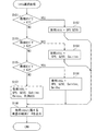
次に図4に示すフローチャートを用いて、システム選択部17が実施するシステム選択処理について説明する。図4に示すフローチャートは、フィルタ部15から観測データが入力される度に開始されれば良い。
<About the operation of the
Next, the system selection processing executed by the
まずステップS101では、環境判定部16による周辺環境の判定結果が第1カテゴリC1であるか否かを判定する。環境判定部16による周辺環境の判定結果が第1カテゴリC1である場合には、ステップS101を肯定判定してステップS102を実行する。ステップS102では、システムランク記憶部M1において第1システムとして登録されているQZSSと、第2システムとして登録されているGPSを、使用システムに設定してステップS108に移る。一方、環境判定部16による周辺環境の判定結果が第1カテゴリC1ではない場合には、ステップS101を否定判定してステップS103を実行する。
First, in step S101, it is determined whether or not the determination result of the surrounding environment by the
ステップS103では、環境判定部16による周辺環境の判定結果が第2カテゴリC2であるか否かを判定する。環境判定部16による周辺環境の判定結果が第2カテゴリC2である場合には、ステップS103を肯定判定してステップS104を実行する。ステップS104では、第1〜第3システムとして登録されている測位システムを、使用システムに設定してステップS108に移る。つまり、GPS、QZSS、及びGalileoを使用システムに設定してステップS108に移る。一方、環境判定部16による周辺環境の判定結果が第2カテゴリC2ではない場合には、ステップS103を否定判定してステップS105を実行する。
In step S103, it is determined whether the determination result of the surrounding environment by the
ステップS105では、環境判定部16による周辺環境の判定結果が第3カテゴリC3であるか否かを判定する。環境判定部16による周辺環境の判定結果が第3カテゴリC3である場合には、ステップS105を肯定判定してステップS106を実行する。ステップS106では、第1〜第4システムとして登録されている測位システムを、使用システムに設定してステップS108に移る。つまり、GPS、QZSS、Galileo及びBeiDouを使用システムに設定してステップS108に移る。
In step S105, it is determined whether the determination result of the surrounding environment by the
一方、環境判定部16による周辺環境の判定結果が第3カテゴリC3ではない場合には、ステップS105を否定判定してステップS107を実行する。なお、環境判定部16による周辺環境の判定結果が第3カテゴリC3ではない場合とは、環境判定部16による周辺環境の判定結果が第4カテゴリC4である場合に相当する。
On the other hand, when the determination result of the surrounding environment by the
ステップS107では、測位装置1が対応している全ての測位システムを、使用システムに設定してステップS108に移る。つまり、GPS、QZSS、Galileo、BeiDou及びGLONASSを使用システムに設定してステップS108に移る。
In step S107, all the positioning systems supported by the
ステップS108では、フィルタ部15から入力された捕捉衛星毎の観測データのうち、使用システムとして設定されている測位システムに属する捕捉衛星についての観測データを測位演算部18に出力して本フローを終了する。なお、後続の処理としては、測位演算部18はシステム選択部17から提供された捕捉衛星毎の観測データを用いて測位演算処理を実施し、現在位置を特定する。測位結果としての位置情報は所定のアプリケーションへと出力される。
In step S108, of the observation data for each acquisition satellite input from the
<実施形態の効果について>
ここでは第1比較構成として、各捕捉衛星についての観測データを周辺環境に応じて測位システム単位で取捨選択することなく、全ての捕捉衛星についての観測データを常に測位演算処理に用いる測位装置を導入し、本実施形態の効果について説明する。
<Effects of the embodiment>
Here, as the first comparison configuration, a positioning device that always uses observation data of all captured satellites for positioning calculation processing without selecting observation data of each captured satellite in units of positioning systems according to the surrounding environment is introduced. Then, the effect of this embodiment is explained.
第1比較構成では、オープンスカイ環境において第1システムに属する測位衛星と、第5システムに属する測位衛星とを捕捉している場合、第1システムに属する捕捉衛星と、第5システムに属する捕捉衛星のそれぞれについての観測データとを組み合わせて測位演算処理を実施する。 In the first comparison configuration, when the positioning satellite belonging to the first system and the positioning satellite belonging to the fifth system are captured in the open sky environment, the capturing satellite belonging to the first system and the capturing satellite belonging to the fifth system. The positioning calculation processing is performed by combining the observation data of each of the above.
ところで、一般的に、オープンスカイ環境では各測位信号の品質が良いため、使用する観測データ(換言すれば捕捉衛星)の数を絞っても十分な情報が得られる。つまり、オープンスカイ環境下では、第1システムだけで十分に高精度測位が可能である。また、オープンスカイ環境下での測位信号の品質や測位精度は、測位システム毎によってばらつきがある。そのため、観測データの数を増やせば増やすほど、測位精度が向上するわけではない。 By the way, generally, in an open sky environment, since the quality of each positioning signal is good, sufficient information can be obtained even if the number of observation data (in other words, acquisition satellites) used is narrowed down. That is, in the open sky environment, sufficiently high-precision positioning is possible with only the first system. In addition, the quality of the positioning signal and the positioning accuracy in the open sky environment vary depending on the positioning system. Therefore, the positioning accuracy does not improve as the number of observation data increases.
そのため、第1比較構成のようにオープンスカイ環境において第1システムに属する捕捉衛星についての観測データと、第5システムに属する捕捉衛星についての観測データとを組み合わせて測位演算処理を実施すると、最終的な測位結果の精度は、第1システム単独での測位精度と、第5システム単独での測位精度の中間レベルとなりうる。つまり、第5システムを併用することによって、第1システム単独で測位した結果に比べて測位精度が劣化してしまう場合がある。 Therefore, if the positioning calculation processing is performed by combining the observation data of the acquisition satellites belonging to the first system and the observation data of the acquisition satellites belonging to the fifth system in the open sky environment as in the first comparison configuration, The accuracy of such a positioning result may be an intermediate level between the positioning accuracy of the first system alone and the positioning accuracy of the fifth system alone. That is, by using the fifth system together, the positioning accuracy may be deteriorated as compared with the result of positioning by the first system alone.
対して、上記の構成によれば、環境判定部16によって周辺環境はマルチパスを受けにくい環境(つまり番号が小さいカテゴリ)であると判定されている場合には、測位装置1が対応している複数の測位システムのうち、相対的に精度がよい測位システムのみを使用システムとして選択する。具体的には、第1システムと第2システムのみを用いて測位演算処理を実施する。これにより、誤差を含んでいる可能性が高い捕捉衛星についての観測データは破棄され、測位演算処理に使用される観測データは、相対的に精度がよい測位システムの捕捉衛星についての観測データとなる。
On the other hand, according to the above configuration, when the
つまり、測位演算処理に用いる観測データ群のなかに、誤差を含む観測データが混ざり込む恐れを低減できる。このような制御態様によれば、観測データの数を増やすことに起因して測位精度が劣化する恐れを低減でき、第1比較構成に比べてより精度良い測位結果を出力することができる。 That is, it is possible to reduce the risk that observation data including an error is mixed in the observation data group used for the positioning calculation process. According to such a control mode, it is possible to reduce the risk that the positioning accuracy is deteriorated due to the increase in the number of observation data, and it is possible to output the positioning result with higher accuracy than the first comparison configuration.
また、一般的に、都市部等のマルチパス環境下では、各測位信号の品質が劣化するため、一般的に、観測データの数が少ないと情報の不足が生じる。本実施形態では、環境判定部16によって周辺環境はマルチパスを受けやすい環境(つまり番号が大きいカテゴリ)であると判定されている場合には、第5システムなど、使用地域において相対的に精度が劣る測位システムも使用システムとして採用する。これにより、測位演算処理に使用可能な捕捉衛星(換言すれば観測データ)の数を増加し、情報の不足が生じる恐れを低減することができる。結果として、第1比較構成に対して測位精度を維持または向上することができる。このように本実施形態の構成によれば、複数のGNSSを併用して測位演算処理を実施する構成(つまりマルチGNSS測位装置)において、周辺環境に応じてGNSSを使い分けることにより、測位精度を高めたり、測位精度を高水準で維持したりすることができる。
In addition, generally, in a multipath environment such as an urban area, the quality of each positioning signal deteriorates, and therefore, in general, a shortage of information occurs when the number of observation data is small. In this embodiment, when the
さらに、上記構成では測位信号の受信状況から定まる削除率Rに基づいて周辺環境のカテゴリを判定する。周辺環境のカテゴリを判定する他の構成(以降、第2比較構成)としては、地図データを用いる構成も考えられる。しかしながら、そのような構成では、測位装置が、地図データが格納された記憶装置、又は、外部サーバと通信して地図データを取得する機能を備えている必要があり、その分だけコストが増大してしまう。対して本実施形態の環境判定部16は、測位信号の受信状況から定まる削除率Rに基づいて周辺環境のカテゴリを判定するため、測位装置1が、地図データを記憶している装置や外部サーバと通信する機能を備えている必要はない。つまり、本実施形態によれば第2比較構成よりも製造コストを抑制することができる。また、広域通信用モジュールを備えないデバイスにも適用できる。
Further, in the above configuration, the category of the surrounding environment is determined based on the deletion rate R determined from the reception status of the positioning signal. As another configuration for determining the category of the surrounding environment (hereinafter, the second comparison configuration), a configuration using map data can be considered. However, in such a configuration, the positioning device needs to have a function of communicating with the storage device storing the map data or the external server to acquire the map data, which increases the cost accordingly. Will end up. On the other hand, since the
また、捕捉衛星数が10のときに5つの観測データを削除した場合(以降、第1ケース)と、捕捉衛星数が30のときに5つの観測データを削除した場合(以降、第2ケース)とでは、観測データの削除数は同じであっても、マルチパスの発生度合いは異なる。当然、第1ケースのほうが、マルチパスの発生し易い環境(換言すれば周囲に構造物が多い環境)であることを示唆している。そのような事情を鑑みれば、仮に観測データの削除数で周辺環境を判別しようとすると、周辺環境を誤判定してしまう恐れが相対的に高い。対して、本実施形態の構成のように、環境判定部16は、観測データを削除した数ではなく、削除した比率(つまり削除率R)によって周辺環境のカテゴリを判別すれば、周辺環境を誤判定してしまう恐れを抑制することができる。換言すれば、周辺環境を判別するための指標として観測データの削除数ではなく削除率Rを用いることにより、より精度良く周辺環境を判別することができる。
In addition, when five observation data are deleted when the number of acquired satellites is 10 (hereinafter, first case), and when five observation data are deleted when the number of acquired satellites is 30 (hereinafter, second case) In and, even if the number of deleted observation data is the same, the degree of occurrence of multipath is different. Naturally, the first case suggests an environment in which multipath is likely to occur (in other words, an environment in which there are many structures around). In view of such circumstances, if it is attempted to determine the surrounding environment based on the number of deleted observation data, there is a relatively high risk of erroneously determining the surrounding environment. On the other hand, as in the configuration of the present embodiment, if the
以上、本開示の実施形態を説明したが、本開示は上述の実施形態に限定されるものではなく、以降で述べる種々の変形例も本開示の技術的範囲に含まれ、さらに、下記以外にも要旨を逸脱しない範囲内で種々変更して実施することができる。もちろん、種々の変形例は適宜組み合わせて実施することができる。 Although the embodiments of the present disclosure have been described above, the present disclosure is not limited to the above-described embodiments, and various modifications described below are also included in the technical scope of the present disclosure. Also, various modifications can be implemented without departing from the scope of the invention. Of course, various modified examples can be implemented in appropriate combination.
なお、前述の実施形態で述べた部材と同一の機能を有する部材については、同一の符号を付し、その説明を省略する。また、構成の一部のみに言及している場合、他の部分については先に説明した実施形態の構成を適用することができる。 It should be noted that members having the same functions as the members described in the above-described embodiment are designated by the same reference numerals, and the description thereof will be omitted. Further, when only a part of the configuration is mentioned, the configurations of the above-described embodiments can be applied to the other parts.
[変形例1]
測位装置1は、フィルタ部15のフィルタリング処理の結果の履歴に基づいて、第1システムに該当する測位システム等を学習し、システムランク記憶部M1に登録されている測位システム毎のランクを随時変更しても良い。ここでは上記の思想に基づく構成を変形例1として説明する。
[Modification 1]
The
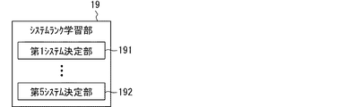
変形例1に示す測位装置1は、図5に示すように上述した実施形態の構成に加えてさらに、システムランク学習部19と履歴記憶部M2とを備える。履歴記憶部M2は、書き換え可能な不揮発性の記憶媒体を用いて実現されている記憶装置である。システムランク学習部19は、CPUが測位プログラムを実行することによって発現される機能ブロックである。もちろん、システムランク学習部19はハードウェアとして実現されていても良い。
The
システムランク学習部19は、フィルタ部15のフィルタリング処理の結果の履歴に基づいて、第1システムに該当する測位システムや、第5システムに該当する測位システム等を特定(換言すれば学習)する構成である。システムランク学習部19の具体的な作動については図6に示すフローチャートを用いて説明する。図6に示すフローチャートは、システムランク学習部19が実施する処理(以降、ランク学習処理)の手順の一例を表したものである。システムランク学習部19は、ランク学習処理を順次実行することで、第1システムに該当する測位システムや、第5システムに該当する測位システムを特定する。図6に示すフローチャートが備える各ステップはシステムランク学習部19によって実行される。
The system
まずステップS201では所定のサンプリング条件が充足されているか否かを判定する。サンプリング条件は、ステップS202のサンプリング処理を実行する状況を規定する条件である。例えばサンプリング条件は、例えば前回サンプリング処理を実施してから所定のサンプル時間経過した場合などとすれば良い。サンプル時間は、フィルタ部15が観測データを出力する間隔に比べて相対的に長い時間に設定されていることが好ましい。例えば、1分や10分、1時間などとすることが好ましい。また、環境判定部16によって周辺環境のカテゴリが中間的なカテゴリ(例えばC2〜C3)に該当する判定されていることを条件に含めても良い。
First, in step S201, it is determined whether or not a predetermined sampling condition is satisfied. The sampling condition is a condition that defines the situation in which the sampling process of step S202 is executed. For example, the sampling condition may be, for example, a case where a predetermined sample time has elapsed since the previous sampling process was performed. It is preferable that the sample time is set to be relatively long as compared with the interval at which the
サンプリング条件が充足されている場合にはステップS201を判定してステップS202を実行する。一方、サンプリング条件が充足されていない場合には、ステップS201を否定判定して待機状態となり、所定時間経過後に再びステップS201を実行する。 If the sampling conditions are satisfied, step S201 is determined and step S202 is executed. On the other hand, if the sampling conditions are not satisfied, the negative determination is made in step S201, the standby state is entered, and step S201 is executed again after a predetermined time has elapsed.
ステップS202ではサンプリング処理として、フィルタ部15によるフィルタリング処理の結果として残った観測データに対応する捕捉衛星(つまり残存衛星)の衛星番号を、残存衛星情報としてフィルタ部15から逐次取得する。また、それとともに、フィルタ部15によるフィルタリング処理によって削除された観測データに対応する捕捉衛星(以降、削除衛星)の衛星番号を、削除衛星情報としてフィルタ部15から取得する。そして、残存衛星情報と削除衛星情報に取得時刻を示すタイムスタンプを付与して履歴記憶部M2に保存する。このようにサンプリング処理はフィルタリング処理の結果をサンプリングする処理に相当する。
In step S202, as the sampling process, the satellite numbers of the captured satellites (that is, remaining satellites) corresponding to the observation data left as a result of the filtering process by the
なお、ステップS202は所定のサンプリング条件が充足される度に繰り返し実行される。或る時点において取得した残存衛星情報は1つのデータセットとして取り扱い、他の時刻に取得した残存衛星情報とは区別して取り扱う。取得時点が異なる複数の残存衛星情報は、最新のデータが先頭となるように時系列順にソートされてメモリに保存されれば良い。また、保存されているデータ数が一定数を超過する場合には古いものから順次破棄されていけば良い。このようにして、履歴記憶部M2には、残存衛星の履歴を示すデータが保存される。 Note that step S202 is repeatedly executed every time a predetermined sampling condition is satisfied. The remaining satellite information acquired at a certain time is treated as one data set, and is treated separately from the remaining satellite information acquired at other times. A plurality of remaining satellite information items having different acquisition times may be sorted in chronological order and stored in the memory so that the latest data is first. Also, when the number of stored data exceeds a certain number, the oldest data may be sequentially discarded. In this way, the history storage unit M2 stores the data indicating the history of the remaining satellites.
削除衛星情報についても、残存衛星情報と同様に、或る時点において取得した削除衛星情報は1つのデータセットとして取り扱い、他の時刻に取得した削除衛星情報とは区別して取り扱う。取得時点が異なる複数の削除衛星情報は、最新のデータが先頭となるように時系列順にソートされてメモリに保存されれば良い。このようにして、履歴記憶部M2には、削除衛星の履歴を示すデータが保存される。 As for the deleted satellite information, like the remaining satellite information, the deleted satellite information acquired at a certain time is treated as one data set, and is treated separately from the deleted satellite information acquired at other times. The plurality of pieces of deleted satellite information that are acquired at different times may be sorted in chronological order and stored in the memory so that the latest data is at the top. In this way, the history storage unit M2 stores data indicating the history of deleted satellites.
ステップS203では、履歴記憶部M2に所定回数(例えば50回)以上のサンプリング処理の結果が保存されているか否かを判定する。つまり、50セット以上の残存衛星情報や削除衛星情報が保存されているか否かを判定する。所定回数以上のサンプリング処理の結果が保存されている場合にはステップS203を肯定判定してステップS204を実行する。一方、所定回数以上のサンプリング処理の結果が保存されていない場合にはステップS203を否定判定してステップS201に戻る。 In step S203, it is determined whether the history storage unit M2 stores the results of the sampling process a predetermined number of times (for example, 50 times) or more. That is, it is determined whether or not 50 sets or more of remaining satellite information and deleted satellite information are stored. When the result of the sampling process of the predetermined number of times or more is stored, the affirmative decision is made in step S203 and the step S204 is executed. On the other hand, when the result of the sampling process of the predetermined number of times or more is not stored, the negative determination is made in step S203 and the process returns to step S201.
ステップS204では、残存衛星情報の履歴を参照し、測位システム毎に、フィルタリング処理の結果として当該測位システムに属する測位衛星が残存している割合(以降、システム残存率)を算出し、システム残存率が高い順に測位システムのランクを決定する。例えば、システム残存率が最も高い測位システムを第1システムに設定する。システム残存率が最も低い測位システムを第5システムに設定する。システム残存率が高いということは、マルチパス等の影響が受けにくい測位システムであることを示唆しているためである。そして、システムランク記憶部M1の保存データを書き換える。 In step S204, the history of remaining satellite information is referred to, and for each positioning system, the ratio of remaining positioning satellites belonging to the positioning system as a result of the filtering process (hereinafter, system remaining rate) is calculated, and the system remaining rate is calculated. The ranking of the positioning system is determined in descending order. For example, the positioning system having the highest system survival rate is set as the first system. The positioning system with the lowest system survival rate is set as the fifth system. The high system survival rate suggests that the positioning system is not easily affected by multipath and the like. Then, the stored data in the system rank storage unit M1 is rewritten.
図7は、システムランク学習部19の概略的な構成を示すブロック図である。第1システム決定部191は、上述したステップS204において、システム残存率が最も高い測位システムを第1システムに設定する構成である。第1システム決定部191が請求項に記載の高精度システム特定部に相当する。第5システム決定部192は、上述したステップS204において、システム残存率が最も低い測位システムを第5システムに設定する構成である。第5システム決定部192が請求項に記載の低精度システム特定部に相当する。
FIG. 7 is a block diagram showing a schematic configuration of the system
このような構成によれば、設計者としては試験等に基づき地域ごとのシステムランクデータを生成する手間を省略することができる。また、測位システムの運用状況の変化(例えば測位衛星の追加/削除等)に由来して、測位システム間の精度の優劣が入れ替わった場合でも柔軟に対応することができる。 With such a configuration, the designer can save the labor of generating the system rank data for each area based on the test or the like. Further, even when the superiority or inferiority of the accuracy between the positioning systems is changed due to a change in the operation status of the positioning system (for example, addition/deletion of positioning satellites, etc.), it is possible to flexibly respond.
なお、システムランク学習部19は、削除衛星情報の履歴に基づいて、測位システム毎に、フィルタリング処理の結果として当該測位システムに属する測位衛星が削除された割合(以降、システム削除率)を算出し、システム削除率が低い順に測位システムのランクを決定してもよい。例えば、システム削除率が最も低い測位システムを第1システムに設定し、システム残存率が最も高い測位システムを第5システムに設定すればよい。そのような態様によっても同様の効果を奏する。
The system
[変形例2]
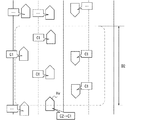
図8に示すように測位装置1が、所定の周波数帯の電波を用いて測位装置1の周辺に存在する他装置と直接的な無線通信(以降、狭域通信)を実施するための通信モジュールである狭域通信部7と相互通信可能に接続されている場合には、狭域通信部7を介して他装置での周辺環境の判定結果を取得し、多数決によって現在の周辺環境のカテゴリを最終的に決定してもよい。そのような構成によれば、測位装置1は、何かしらの理由で自装置のみが周辺環境のカテゴリを誤判定している場合に、当該誤りを修正することができる。つまり、最終的に使用されるカテゴリの精度や信頼度を高めることができる。
[Modification 2]
As shown in FIG. 8, the communication module for the
以下、上記の思想に基づく構成を変形例2として説明する。なお、上述の狭域通信とは、換言すれば、広域通信網を介さない通信である。ここでは一例として、測位装置1が車両に搭載されていることを踏まえ、狭域通信部7は車両Hvの周辺に存在する他車両と直接的な(つまり車車間通信)を実施するための通信モジュールとする。
Hereinafter, a configuration based on the above idea will be described as a modified example 2. In addition, the above-mentioned short-range communication is, in other words, communication that does not go through a wide area communication network. Here, as an example, based on the fact that the
車車間通信に用いられる周波数帯は、たとえば、760MHz帯である。その他、2.4GHz、5.9GHz帯などを用いることもできる。車車間通信を実現するための通信規格は任意のものを採用することができる。たとえば、IEEE1609等にて開示されているWAVE(Wireless Access in Vehicular Environment)の規格を採用することができる。 The frequency band used for inter-vehicle communication is, for example, the 760 MHz band. In addition, 2.4 GHz, 5.9 GHz band, etc. can also be used. Any communication standard can be adopted for realizing the inter-vehicle communication. For example, the WAVE (Wireless Access in Vehicular Environment) standard disclosed in IEEE 1609 or the like can be adopted.
車車間通信用の通信モジュールとしての狭域通信部7は、自車両Hvを中心とする半径数百m以内に存在する他車両と通信可能に構成されている。なお、ここでは一例として狭域通信部7は、通信範囲が数百m程度となる車車間通信規格に準拠した無線通信機能を提供する通信モジュールとするが、これに限らない。他の態様として狭域通信部7は、通信範囲が例えば最大でも数十メートル程度となる所定の近距離無線通信規格に準拠した通信(以降、近距離通信とする)を実施する通信モジュールであっても良い。例えばBluetooth Low Energy(Bluetoothは登録商標)や、Wi−Fi(登録商標)、ZigBee(登録商標)等が上述した近距離無線通信規格に該当する。
The short-
狭域通信部7は、測位装置1(特に環境判定部16)からの要求に基づいて、自装置の環境判定部16が判定したカテゴリを示すカテゴリ情報(例えばカテゴリ番号)を示す判定結果パケットを同報送信する。また、他車両から送信される判定結果パケットを受信すると、当該判定結果パケットに示されるデータを測位装置1に提供する。なお、前提として本変形例2における環境判定部16は、フィルタ部15から入力された削除率に基づいた周辺環境のカテゴリの判定を実施する度に、判定結果パケットを生成し、狭域通信部7に出力して同報送信させる。
The short-
判定結果パケットは、周辺環境の判定結果を示す情報(例えばカテゴリ番号)と、測位演算部18の演算結果として位置情報とを含む通信パケットである。また、ここではより好ましい態様として、判定結果パケットには、カテゴリ番号や現在位置情報に加えて、当該通信パケットの送信時刻や、走行速度、進行方向を示す情報が含まれているものとする。
The determination result packet is a communication packet that includes information indicating the determination result of the surrounding environment (for example, a category number) and position information as the calculation result of the
本変形例における環境判定部16は、狭域通信部7と協働して図9に示すように自車両Hvから所定の距離D1以内に存在する他車両(以降、周辺車両)の判定結果を逐次取得する。また、周辺車両と自車両Hvのそれぞれの判定結果を母集団とした多数決によって周辺環境が何れのカテゴリに該当するかを最終的に決定する多数決部161を備える。
The
この多数決部161は、例えば図9に示すように、自分自身は第2カテゴリC2であると判定している状況において周辺車両の判定結果として周辺環境は第1カテゴリC1であるという判定結果が多数派である場合には、最終的に周辺環境は第1カテゴリC1であると判定する。つまり、周辺環境は第2カテゴリC2であるという自分自身の判定結果を破棄して、周辺環境のカテゴリを第1カテゴリであると判定する。
For example, as shown in FIG. 9, the
距離D1は、例えば数十メートル程度(例えば15m)など、車車間通信可能な距離に比べて十分に小さい値に設定されていることが好ましい。自車両Hvから離れている場所を走行している他車両にとっての周辺環境は、自車両Hvの周辺環境とは異なる可能性が高いためである。車車間通信をしている他車両のうち、周辺車両に該当する他車両は、自車両Hvの現在位置と送信元車両の現在位置とを用いて抽出すれば良い。現在位置が、自車両Hvから距離D1以内となっている送信元車両を周辺車両として採用すれば良い。自車両Hvに搭載されている測位装置1が請求項に記載の自装置に相当し、周辺車両に搭載されている測位装置1が請求項に記載の周辺装置に相当する。
The distance D1 is preferably set to a value that is sufficiently smaller than the distance at which vehicle-to-vehicle communication is possible, such as several tens of meters (for example, 15 m). This is because there is a high possibility that the surrounding environment for another vehicle traveling in a place away from the own vehicle Hv is different from the surrounding environment of the own vehicle Hv. Of the other vehicles that are performing inter-vehicle communication, other vehicles that correspond to surrounding vehicles may be extracted using the current position of the host vehicle Hv and the current position of the transmission source vehicle. A transmission source vehicle whose current position is within the distance D1 from the host vehicle Hv may be adopted as a peripheral vehicle. The
このような変形例2の構成によれば、冒頭にも記載の通り、測位装置1は、何かしらの理由で自装置のみが周辺環境のカテゴリを誤判定している場合に、当該誤りを修正することができる。その結果、最終的に使用されるカテゴリの精度や信頼度を高めることができる。
According to the configuration of the second modification, as described at the beginning, the
なお、多数決部161は、周辺車両の判定結果と自車両Hvの判定結果の中で最も出現数が多い(換言すれば多数派の)判定結果である最頻カテゴリが、全体の過半数を超えている場合にのみ、周辺環境は多数派の判定結果を採用するようにしてもよい。最頻カテゴリが過半数を超えていないということは、車両(より具体的には測位装置1)毎の判定結果が割れていることを意味し、多数派の判定結果が必ずしも正しい判定結果とは限らないためである。つまり、多数派の判定結果が過半数を超えている場合にのみ多数派の判定結果を採用することで、周辺環境の判定精度を高めることができる。また、自分自身が周辺環境を正しく判定できていたにも関わらず、周辺車両の判定結果に引っ張られて誤った判定結果を最終的なカテゴリとして採用してしまう恐れも低減できる。
The
なお、上述した構成では、自車両Hvから距離D1以内に位置する他車両の判定結果を用いて、最終的な周辺環境を決定する態様を開示したが、これに限らない。図10に示すように、車車間通信を実施している車両のうち、自車両Hvの前方であって、且つ、自車両Hvから距離D2以内に存在する他車両の判定結果を用いて(換言すれば母集団として)、最終的な周辺環境を決定してもよい。 In addition, in the above-mentioned structure, although the aspect which determines a final surrounding environment using the determination result of the other vehicle located within the distance D1 from the own vehicle Hv was disclosed, it is not restricted to this. As shown in FIG. 10, among the vehicles that are performing inter-vehicle communication, the determination results of other vehicles that are in front of the own vehicle Hv and within a distance D2 from the own vehicle Hv are used (in other words, The final surrounding environment may then be determined).
これは次の理由による。カテゴリを決定するための削除率Rは、過去一定時間以内の観測データを元に定まる統計的な指標である擬似距離散布度によって変化する。実際の周辺環境が変化したとしても、擬似距離散布度が所定の削除閾値を超えるまでは、削除率Rの変化としては表れない。つまり、実際の周辺環境の変化が環境判定部16の判定結果に反映されるまでには擬似距離散布度を算出するためのデータ数に応じた時間がかかる。
This is for the following reason. The deletion rate R for determining the category changes according to the pseudo-range dispersion degree, which is a statistical index determined based on observation data within a certain time period in the past. Even if the actual surrounding environment changes, it does not appear as a change in the deletion rate R until the pseudo distance dispersion exceeds a predetermined deletion threshold. That is, it takes a time corresponding to the number of data for calculating the pseudo distance dispersion degree before the actual change in the surrounding environment is reflected in the determination result of the
そのような性質を鑑みると、自車両Hvの後方を走行している他車両の判定結果よりも、自車両Hvの前方を走行している他車両の判定結果のほうが、自車両Hvの周辺環境を正しく判定している可能性が高い。故に、自車両Hv前方であって、且つ、自車両Hvから距離D2以内に存在する他車両の判定結果を用いて最終的な周辺環境のカテゴリを決定するように構成することで、カテゴリの判定精度を高めることができる。なお、距離D2は距離D1と同程度値とすればよい。 In view of such a property, the determination result of the other vehicle traveling in front of the own vehicle Hv is closer to the surrounding environment of the own vehicle Hv than the determination result of the other vehicle traveling in the rear of the own vehicle Hv. It is highly possible that Therefore, it is configured to determine the final category of the surrounding environment by using the determination result of another vehicle that is in front of the own vehicle Hv and is within the distance D2 from the own vehicle Hv. The accuracy can be increased. It should be noted that the distance D2 may be set to the same value as the distance D1.
また、例えば自車両Hvの前方を走行している他車両のうち、自車両Hvと進行方向を同一とする他車両の判定結果のみと自車両Hvの判定結果を用いて最終的な周辺環境のカテゴリを決定してもよい。 Further, for example, among the other vehicles traveling in front of the host vehicle Hv, only the determination result of the other vehicle having the same traveling direction as the host vehicle Hv and the determination result of the host vehicle Hv are used to determine the final surrounding environment. You may decide the category.
さらに、高速道路上と当該高速道路の下に配置されている一般道路(以降、高速沿道)上とでは、周辺環境は異なるといえる。当然、高速道路上のほうが上空視界の見晴らしはよく、高速沿道では上空視界の見晴らしは悪い。そのような課題に着眼し、自車両Hvの周辺を走行している他車両のうち、自車両Hvと同じ種別の道路を走行している他車両の自車両Hvの判定結果を用いて最終的な周辺環境のカテゴリを決定することが好ましい。自車両Hvと同じ種別の道路を走行しているか否かは、車車間通信で走行路の種別を共有することによって特定しても良いし、位置情報に含まれる高さ情報に基づいて判別してもよい。また、高速道路と一般道路では走行速度に有意の差が生じるため、走行速度が同じレベル(例えば±10キロ以内)であるか否かによって判別することもできる。 Furthermore, it can be said that the surrounding environment is different on an expressway and on a general road (hereinafter referred to as a highway) arranged below the expressway. Obviously, the view of the sky above the highway is better, and the view of the sky above the highway is worse. Focusing on such a problem, among other vehicles traveling around the own vehicle Hv, a final result is obtained by using the determination result of the own vehicle Hv of another vehicle traveling on the same type road as the own vehicle Hv. It is preferable to determine the category of the surrounding environment. Whether or not the vehicle is traveling on the same type of road as the own vehicle Hv may be specified by sharing the type of the traveling road through vehicle-to-vehicle communication, or may be determined based on height information included in the position information. May be. Further, since there is a significant difference between the traveling speeds on the expressway and the general road, it is possible to determine whether or not the traveling speeds are at the same level (for example, within ±10 km).
[変形例3]
上述した実施形態では、測位装置1が5つの測位システムに対応している態様を記載したがこれに限らない。測位装置1が対応している測位システムの数は2つだけであっても良い。例えば、測位装置1が対応している測位システムは、BeiDouとGLONASSの2つであっても良い。また、測位装置1が対応している測位システムの数は3つであっても良い。例えば測位装置1が対応している測位システムは、GPSとQZSSとGLONASSの3つであっても良い。すなわち、測位装置1が対応している測位システムの数は2、3、4、6などであっても良い。また、インドのIRNSS(Indian Regional Navigation Satellite System)など、上述した測位システム以外に対応していても良い。
[Modification 3]
In the above-described embodiment, the mode in which the
なお、ここでの測位装置1が対応している測位システムとは、測位装置1が当該測位システムの測位信号を受信可能であって、当該測位システムの測位信号を用いて測位演算処理を実行可能なシステムを指す。或る測位システムの測位信号とは当該測位システムを構成する測位衛星から送信される測位信号に相当する。
Note that the positioning system supported by the
1 測位装置、2〜5 測位衛星、6 準天頂衛星、7 狭域通信部、11 搬送波受信部、12 受信処理部、13 散布度算出部、14 出力部、15 フィルタ部、16 環境判定部、17 システム選択部、18 測位演算部、19 システムランク学習部、161 多数決部、191 高精度システム特定部、192 低精度システム特定部、M1 システムランク記憶部、M2 履歴記憶部 1 positioning device, 2-5 positioning satellites, 6 quasi-zenith satellites, 7 narrow-range communication section, 11 carrier wave receiving section, 12 reception processing section, 13 dispersion degree calculating section, 14 output section, 15 filter section, 16 environment judging section, 17 system selection unit, 18 positioning calculation unit, 19 system rank learning unit, 161 majority decision unit, 191 high precision system identification unit, 192 low precision system identification unit, M1 system rank storage unit, M2 history storage unit
Claims (8)
複数の前記測位システムのそれぞれが備える複数の測位衛星から送信される測位信号を受信する信号受信部(11)と、
前記信号受信部が受信した測位信号に基づいて、受信した測位信号の送信元としての測位衛星についてのドップラーシフト量及び擬似距離の少なくとも何れか一方を、マルチパス環境下であるか否かを判定するための指標値として逐次算出する指標値算出部(12)と、
前記信号受信部で測位信号を受信できている測位衛星である捕捉衛星毎に、その捕捉衛星に対して前記指標値算出部が算出した前記指標値のばらつき度合いを示す指標値散布度を算出する散布度算出部(13)と、
前記散布度算出部が算出した前記捕捉衛星毎の前記指標値散布度に基づいて、複数の前記捕捉衛星のうち、測位演算処理に使用しない前記捕捉衛星である不使用衛星を決定する衛星選択部(15)と、
前記捕捉衛星の総数に対する前記衛星選択部によって不使用衛星に設定された前記捕捉衛星の数の比である削除率に基づいて、周辺環境はマルチパスが発生しやすい環境であるか否かを判定する環境判定部(16)と、を備え、
前記環境判定部の判定結果に応じて、複数の前記測位システムのうち、測位演算処理に使用する前記測位システムである使用システムを少なくとも1つ選択するシステム選択部(17)と、
前記衛星選択部によって前記不使用衛星に設定されなかった前記捕捉衛星である残存衛星のなかで、前記システム選択部によって前記使用システムとして選択された前記測位システムが備える測位衛星からの測位信号を用いて測位演算処理を実施する測位演算部(18)と、
前記測位装置が対応している複数の前記測位システムの平均的な測位精度の順位を示すデータが登録されているシステムランク記憶部(M1)とを備え、
前記システム選択部は、前記環境判定部が前記削除率に基づき周辺環境はマルチパスが発生しやすい環境ではないと判定している場合には、複数の前記測位システムのうち、前記システムランク記憶部において測位精度が最も低い前記測位システムとして登録されている低精度システムは前記使用システムには設定せず、
前記測位演算部は、前記低精度システムに属する測位衛星からの測位信号は測位演算処理に用いず、
前記環境判定部は、マルチパスの発生のしやすさに応じて段階的に予め設定されている複数のカテゴリのうちの何れに周辺環境は該当するかを前記削除率に基づいて判定するものであって、
複数の前記カテゴリには、少なくとも、マルチパスが最も発生しにくいオープンスカイ環境に相当するカテゴリであるオープンスカイカテゴリと、マルチパスが最も発生しやすい都市部に相当するカテゴリである都市部カテゴリとが含まれており、
前記システム選択部は、前記環境判定部によって判定された周辺環境がよりマルチパスの発生しやすいカテゴリであるほど、前記使用システムとして選択する前記測位システムの数を増やすように構成されている測位装置。 A positioning device capable of executing positioning calculation processing by combining positioning signals of a plurality of positioning systems,
A signal receiving unit (11) for receiving positioning signals transmitted from a plurality of positioning satellites included in each of the plurality of positioning systems;
Based on the positioning signal received by the signal receiving unit, it is determined whether or not at least one of the Doppler shift amount and the pseudo range for the positioning satellite as the transmission source of the received positioning signal is in a multipath environment. An index value calculation unit (12) that sequentially calculates as an index value for
For each acquisition satellite that is a positioning satellite that can receive the positioning signal in the signal receiving unit, calculate an index value dispersion degree indicating the degree of dispersion of the index value calculated by the index value calculation unit with respect to the acquisition satellite. A dispersion degree calculation unit (13),
A satellite selection unit that determines an unused satellite that is the acquisition satellite that is not used for positioning calculation processing among the plurality of acquisition satellites based on the index value dispersion degree for each acquisition satellite calculated by the dispersion degree calculation unit (15),
It is determined whether or not the surrounding environment is an environment in which multipath is likely to occur, based on a deletion rate which is a ratio of the number of the acquired satellites set to the unused satellites by the satellite selection unit with respect to the total number of the acquired satellites. And an environment determination unit (16)
A system selection unit (17) that selects at least one used system, which is the positioning system used for the positioning calculation processing, from among the plurality of positioning systems according to the determination result of the environment determination unit;
Among the remaining satellites that are the acquisition satellites that have not been set as the unused satellites by the satellite selection unit, the positioning signals from the positioning satellites included in the positioning system selected as the usage system by the system selection unit are used. A positioning calculation unit (18) that performs positioning calculation processing by
A system rank storage unit (M1) in which data indicating the order of average positioning accuracy of the plurality of positioning systems supported by the positioning device is registered,
When the environment determination unit determines that the surrounding environment is not an environment where multipath is likely to occur based on the deletion rate, the system selection unit selects the system rank storage unit from among the plurality of positioning systems. In the low accuracy system registered as the positioning system with the lowest positioning accuracy in, do not set in the use system,
The positioning calculation unit does not use positioning signals from positioning satellites belonging to the low-accuracy system for positioning calculation processing,
The environment determining unit determines, based on the deletion rate, which one of a plurality of categories that is preset in a stepwise manner according to the likelihood of occurrence of multipaths corresponds to the surrounding environment. There
In the plurality of the categories, at least an open sky category that is a category corresponding to an open sky environment in which multipath is less likely to occur, and an urban area category that is a category corresponding to an urban area where multipath is most likely to occur Included,
A positioning device configured such that the system selection unit increases the number of the positioning systems to be selected as the use system as the surrounding environment determined by the environment determination unit is a category in which multipath is more likely to occur. ..
前記衛星選択部による前記不使用衛星を選択する処理であるフィルタリング処理の結果としての、過去一定回数のフィルタリング処理の結果として残った観測データに対応する捕捉衛星の衛星番号、又は、過去一定回数のフィルタリング処理によって削除された観測データに対応する捕捉衛星の衛星番号に基づいて、複数の前記測位システムの中で測位精度が最も高い前記測位システムを特定し、当該測位システムを、複数の前記測位システムの中で測位精度が最も高い前記測位システムである高精度システムとして前記システムランク記憶部に登録する高精度システム特定部(191)を備える測位装置。 The positioning device according to claim 1 , wherein
As a result of the filtering process that is a process of selecting the unused satellites by the satellite selection unit, the satellite number of the acquisition satellite corresponding to the observation data remaining as a result of the filtering process of the past fixed number, or the fixed number of the past Based on the satellite number of the acquisition satellite corresponding to the observation data deleted by the filtering process, the positioning system having the highest positioning accuracy among the plurality of positioning systems is specified, and the positioning system is set to the plurality of positioning systems. A positioning device including a high-precision system specifying unit (191) registered in the system rank storage unit as a high-precision system that is the positioning system with the highest positioning accuracy among the above.
前記システム選択部は、
前記環境判定部によって周辺環境は前記オープンスカイカテゴリであると判定されている場合には、前記システムランク記憶部において測位精度が最も高い前記測位システムとして登録されている高精度システムを前記使用システムとして選択する一方、前記低精度システムは前記使用システムに選択せず、
前記環境判定部によって周辺環境は前記都市部カテゴリであると判定されている場合には、前記低精度システムを含む全ての前記測位システムを前記使用システムに選択する測位装置。 The positioning device according to claim 1 or 2 , wherein
The system selection unit,
When the surrounding environment is determined to be the open sky category by the environment determination unit, a high-precision system registered as the positioning system with the highest positioning accuracy in the system rank storage unit is used as the usage system. While choosing, the low precision system does not choose to use the system,
A positioning device that selects all of the positioning systems including the low-accuracy system as the usage system when the environment determining unit determines that the surrounding environment is the urban category.
前記測位装置としての自装置から所定距離以内に存在する他の前記測位装置である周辺装置と直接的に通信するための狭域通信部(7)と相互通信可能に接続されており、
前記環境判定部は、前記狭域通信部と協働して、前記自装置の前記環境判定部が前記削除率に基づいて判定したカテゴリを示すカテゴリ情報を前記周辺装置に同報送信するように構成されており、
前記周辺装置のそれぞれが判定した周辺環境のカテゴリを前記狭域通信部と協働して取得するとともに、前記周辺装置と前記自装置の判定結果を用いた多数決によって、周辺環境が何れのカテゴリに該当するかを最終的に決定する多数決部(161)を備える測位装置。 The positioning device according to any one of claims 1 to 3 ,
The positioning device is connected to a narrow area communication unit (7) for direct communication with another peripheral device, which is the positioning device, present within a predetermined distance from the device itself,
The environment determination unit, in cooperation with the short-range communication unit, broadcasts category information indicating a category determined by the environment determination unit of the own device based on the deletion rate to the peripheral device. Is configured,
Along with acquiring the category of the surrounding environment determined by each of the peripheral devices in cooperation with the narrow area communication unit, the category of the surrounding environment is determined by a majority decision using the determination results of the peripheral device and the own device. A positioning device that includes a majority decision unit (161) that finally decides whether or not it is applicable.
前記多数決部は、前記周辺装置の判定結果と前記自装置の判定結果の中で最も出現数が多い判定結果である最頻カテゴリの出現数が過半数を超えている場合には、周辺環境は前記最頻カテゴリに該当すると判定する一方、前記最頻カテゴリの出現数が過半数を超えていない場合には前記自装置の判定結果を最終的な周辺環境として採用する測位装置。 The positioning device according to claim 4 ,
The majority decision unit, if the number of appearances of the most frequent category, which is the determination result with the largest number of appearances in the determination result of the peripheral device and the determination result of the own device, exceeds a majority, the surrounding environment is A positioning device that determines that it belongs to the most frequent category, while adopting the determination result of the own device as a final surrounding environment when the number of appearances of the most frequent category does not exceed a majority.
複数の前記測位システムのそれぞれが備える複数の測位衛星から送信される測位信号を受信する信号受信部(11)と、
前記信号受信部が受信した測位信号に基づいて、受信した測位信号の送信元としての測位衛星についてのドップラーシフト量及び擬似距離の少なくとも何れか一方を、マルチパス環境下であるか否かを判定するための指標値として逐次算出する指標値算出部(12)と、
前記信号受信部で測位信号を受信できている測位衛星である捕捉衛星毎に、その捕捉衛星に対して前記指標値算出部が算出した前記指標値のばらつき度合いを示す指標値散布度を算出する散布度算出部(13)と、
前記散布度算出部が算出した前記捕捉衛星毎の前記指標値散布度に基づいて、複数の前記捕捉衛星のうち、測位演算処理に使用しない前記捕捉衛星である不使用衛星を決定する衛星選択部(15)と、
前記捕捉衛星の総数に対する前記衛星選択部によって不使用衛星に設定された前記捕捉衛星の数の比である削除率に基づいて、周辺環境はマルチパスが発生しやすい環境であるか否かを判定する環境判定部(16)と、を備え、
前記環境判定部の判定結果に応じて、複数の前記測位システムのうち、測位演算処理に使用する前記測位システムである使用システムを少なくとも1つ選択するシステム選択部(17)と、
前記衛星選択部によって前記不使用衛星に設定されなかった前記捕捉衛星である残存衛星のなかで、前記システム選択部によって前記使用システムとして選択された前記測位システムが備える測位衛星からの測位信号を用いて測位演算処理を実施する測位演算部(18)と、
前記測位装置が対応している複数の前記測位システムの平均的な測位精度の順位を示すデータが登録されているシステムランク記憶部(M1)とを備え、
前記システム選択部は、前記環境判定部が前記削除率に基づき周辺環境はマルチパスが発生しやすい環境ではないと判定している場合には、複数の前記測位システムのうち、前記システムランク記憶部において測位精度が最も低い前記測位システムとして登録されている低精度システムは前記使用システムには設定せず、
前記測位演算部は、前記低精度システムに属する測位衛星からの測位信号は測位演算処理に用いず、
前記衛星選択部による前記不使用衛星を選択する処理であるフィルタリング処理の結果としての、過去一定回数のフィルタリング処理の結果として残った観測データに対応する捕捉衛星の衛星番号、又は、過去一定回数のフィルタリング処理によって削除された観測データに対応する捕捉衛星の衛星番号に基づいて、複数の前記測位システムの中で測位精度が最も高い前記測位システムを特定し、当該測位システムを、複数の前記測位システムの中で測位精度が最も高い前記測位システムである高精度システムとして前記システムランク記憶部に登録する高精度システム特定部(191)を備える測位装置。 A positioning device capable of executing positioning calculation processing by combining positioning signals of a plurality of positioning systems,
A signal receiving unit (11) for receiving positioning signals transmitted from a plurality of positioning satellites included in each of the plurality of positioning systems;
Based on the positioning signal received by the signal receiving unit, it is determined whether or not at least one of the Doppler shift amount and the pseudo range for the positioning satellite as the transmission source of the received positioning signal is in a multipath environment. An index value calculation unit (12) that sequentially calculates as an index value for
For each acquisition satellite that is a positioning satellite that can receive the positioning signal in the signal receiving unit, calculate an index value dispersion degree indicating the degree of dispersion of the index value calculated by the index value calculation unit with respect to the acquisition satellite. A dispersion degree calculation unit (13),
A satellite selection unit that determines an unused satellite that is the acquisition satellite that is not used for positioning calculation processing among the plurality of acquisition satellites based on the index value dispersion degree for each acquisition satellite calculated by the dispersion degree calculation unit (15),
It is determined whether or not the surrounding environment is an environment in which multipath is likely to occur, based on a deletion rate which is a ratio of the number of the acquired satellites set to the unused satellites by the satellite selection unit with respect to the total number of the acquired satellites. And an environment determination unit (16)
A system selection unit (17) that selects at least one used system, which is the positioning system used for the positioning calculation processing, from among the plurality of positioning systems according to the determination result of the environment determination unit;
Among the remaining satellites that are the acquisition satellites that have not been set as the unused satellites by the satellite selection unit, the positioning signals from the positioning satellites included in the positioning system selected as the usage system by the system selection unit are used. A positioning calculation unit (18) that performs positioning calculation processing by
A system rank storage unit (M1) in which data indicating the order of average positioning accuracy of the plurality of positioning systems supported by the positioning device is registered,
When the environment determination unit determines that the surrounding environment is not an environment where multipath is likely to occur based on the deletion rate, the system selection unit selects the system rank storage unit from among the plurality of positioning systems. In the low accuracy system registered as the positioning system with the lowest positioning accuracy in, do not set in the use system,
The positioning calculation unit does not use positioning signals from positioning satellites belonging to the low-accuracy system for positioning calculation processing,
As a result of the filtering process that is a process of selecting the unused satellites by the satellite selection unit, the satellite number of the acquisition satellite corresponding to the observation data remaining as a result of the filtering process of the past fixed number, or the fixed number of the past Based on the satellite number of the acquisition satellite corresponding to the observation data deleted by the filtering process, the positioning system having the highest positioning accuracy among the plurality of positioning systems is specified, and the positioning system is set to the plurality of positioning systems. A positioning device including a high-precision system specifying unit (191) registered in the system rank storage unit as a high-precision system that is the positioning system with the highest positioning accuracy among the above .
前記衛星選択部による前記不使用衛星を選択する処理であるフィルタリング処理の結果としての、過去一定回数のフィルタリング処理の結果として残った観測データに対応する捕捉衛星の衛星番号、又は、過去一定回数のフィルタリング処理によって削除された観測データに対応する捕捉衛星の衛星番号に基づいて、複数の前記測位システムの中で測位精度が最も低い前記測位システムを特定し、当該測位システムを前記低精度システムとして前記システムランク記憶部に登録する低精度システム特定部(192)を備える測位装置。 The positioning device according to any one of claims 1 to 6 ,
As a result of the filtering process that is a process of selecting the unused satellites by the satellite selection unit, the satellite number of the acquisition satellite corresponding to the observation data remaining as a result of the filtering process of the past fixed number, or the fixed number of the past Based on the satellite number of the acquisition satellite corresponding to the observation data deleted by the filtering process, the positioning system having the lowest positioning accuracy among the plurality of positioning systems is specified, and the positioning system is used as the low accuracy system. A positioning device comprising a low-precision system identification unit (192) registered in the system rank storage unit.
複数の前記測位システムのそれぞれが備える複数の測位衛星から送信される測位信号を受信する信号受信部(11)と、
前記信号受信部が受信した測位信号に基づいて、受信した測位信号の送信元としての測位衛星についてのドップラーシフト量及び擬似距離の少なくとも何れか一方を、マルチパス環境下であるか否かを判定するための指標値として逐次算出する指標値算出部(12)と、
前記信号受信部で測位信号を受信できている測位衛星である捕捉衛星毎に、その捕捉衛星に対して前記指標値算出部が算出した前記指標値のばらつき度合いを示す指標値散布度を算出する散布度算出部(13)と、
前記散布度算出部が算出した前記捕捉衛星毎の前記指標値散布度に基づいて、複数の前記捕捉衛星のうち、測位演算処理に使用しない前記捕捉衛星である不使用衛星を決定する衛星選択部(15)と、
前記捕捉衛星の総数に対する前記衛星選択部によって不使用衛星に設定された前記捕捉衛星の数の比である削除率に基づいて、周辺環境はマルチパスが発生しやすい環境であるか否かを判定する環境判定部(16)と、を備え、
前記環境判定部の判定結果に応じて、複数の前記測位システムのうち、測位演算処理に使用する前記測位システムである使用システムを少なくとも1つ選択するシステム選択部(17)と、
前記衛星選択部によって前記不使用衛星に設定されなかった前記捕捉衛星である残存衛星のなかで、前記システム選択部によって前記使用システムとして選択された前記測位システムが備える測位衛星からの測位信号を用いて測位演算処理を実施する測位演算部(18)と、
前記測位装置が対応している複数の前記測位システムの平均的な測位精度の順位を示すデータが登録されているシステムランク記憶部(M1)とを備え、
前記システム選択部は、前記環境判定部が前記削除率に基づき周辺環境はマルチパスが発生しやすい環境ではないと判定している場合には、複数の前記測位システムのうち、前記システムランク記憶部において測位精度が最も低い前記測位システムとして登録されている低精度システムは前記使用システムには設定せず、
前記測位演算部は、前記低精度システムに属する測位衛星からの測位信号は測位演算処理に用いず、
前記衛星選択部による前記不使用衛星を選択する処理であるフィルタリング処理の結果としての、過去一定回数のフィルタリング処理の結果として残った観測データに対応する捕捉衛星の衛星番号、又は、過去一定回数のフィルタリング処理によって削除された観測データに対応する捕捉衛星の衛星番号に基づいて、複数の前記測位システムの中で測位精度が最も低い前記測位システムを特定し、当該測位システムを前記低精度システムとして前記システムランク記憶部に登録する低精度システム特定部(192)を備える測位装置。 A positioning device capable of executing positioning calculation processing by combining positioning signals of a plurality of positioning systems,
A signal receiving unit (11) for receiving positioning signals transmitted from a plurality of positioning satellites included in each of the plurality of positioning systems;
Based on the positioning signal received by the signal receiving unit, it is determined whether or not at least one of the Doppler shift amount and the pseudo range for the positioning satellite as the transmission source of the received positioning signal is in a multipath environment. An index value calculation unit (12) that sequentially calculates as an index value for
For each acquisition satellite that is a positioning satellite that can receive the positioning signal in the signal receiving unit, calculate an index value dispersion degree indicating the degree of dispersion of the index value calculated by the index value calculation unit with respect to the acquisition satellite. A dispersion degree calculation unit (13),
A satellite selection unit that determines an unused satellite that is the acquisition satellite that is not used for positioning calculation processing among the plurality of acquisition satellites based on the index value dispersion degree for each acquisition satellite calculated by the dispersion degree calculation unit (15),
It is determined whether or not the surrounding environment is an environment in which multipath is likely to occur, based on a deletion rate which is a ratio of the number of the acquired satellites set to the unused satellites by the satellite selection unit with respect to the total number of the acquired satellites. And an environment determination unit (16)
A system selection unit (17) that selects at least one used system, which is the positioning system used for the positioning calculation processing, from among the plurality of positioning systems according to the determination result of the environment determination unit;
Among the remaining satellites that are the acquisition satellites that have not been set as the unused satellites by the satellite selection unit, the positioning signals from the positioning satellites included in the positioning system selected as the usage system by the system selection unit are used. A positioning calculation unit (18) that performs positioning calculation processing by
A system rank storage unit (M1) in which data indicating the order of average positioning accuracy of the plurality of positioning systems supported by the positioning device is registered,
When the environment determination unit determines that the surrounding environment is not an environment where multipath is likely to occur based on the deletion rate, the system selection unit selects the system rank storage unit from among the plurality of positioning systems. In the low accuracy system registered as the positioning system with the lowest positioning accuracy in, do not set in the use system,
The positioning calculation unit does not use positioning signals from positioning satellites belonging to the low-accuracy system for positioning calculation processing,
As a result of the filtering process that is a process of selecting the unused satellites by the satellite selection unit, the satellite number of the acquisition satellite corresponding to the observation data remaining as a result of the filtering process of the past fixed number, or the fixed number of the past Based on the satellite number of the acquisition satellite corresponding to the observation data deleted by the filtering process, the positioning system having the lowest positioning accuracy among the plurality of positioning systems is specified, and the positioning system is used as the low accuracy system. A positioning device comprising a low-precision system identification unit (192) registered in the system rank storage unit .
Priority Applications (3)
| Application Number | Priority Date | Filing Date | Title |
|---|---|---|---|
| JP2017133973A JP6733619B2 (en) | 2017-07-07 | 2017-07-07 | Positioning device |
| PCT/JP2018/012619 WO2019008844A1 (en) | 2017-07-07 | 2018-03-28 | Positioning device |
| US16/723,496 US11275180B2 (en) | 2017-07-07 | 2019-12-20 | Positioning device and positioning method |
Applications Claiming Priority (1)
| Application Number | Priority Date | Filing Date | Title |
|---|---|---|---|
| JP2017133973A JP6733619B2 (en) | 2017-07-07 | 2017-07-07 | Positioning device |
Publications (3)
| Publication Number | Publication Date |
|---|---|
| JP2019015637A JP2019015637A (en) | 2019-01-31 |
| JP2019015637A5 JP2019015637A5 (en) | 2019-08-15 |
| JP6733619B2 true JP6733619B2 (en) | 2020-08-05 |
Family
ID=64949852
Family Applications (1)
| Application Number | Title | Priority Date | Filing Date |
|---|---|---|---|
| JP2017133973A Expired - Fee Related JP6733619B2 (en) | 2017-07-07 | 2017-07-07 | Positioning device |
Country Status (3)
| Country | Link |
|---|---|
| US (1) | US11275180B2 (en) |
| JP (1) | JP6733619B2 (en) |
| WO (1) | WO2019008844A1 (en) |
Families Citing this family (4)
| Publication number | Priority date | Publication date | Assignee | Title |
|---|---|---|---|---|
| JP6743777B2 (en) * | 2017-07-07 | 2020-08-19 | 株式会社デンソー | Positioning device |
| JP6987711B2 (en) * | 2018-07-13 | 2022-01-05 | 株式会社クボタ | Working machine |
| CN110988943A (en) * | 2019-12-28 | 2020-04-10 | 国网山西省电力公司检修分公司 | System and method for positioning staff in transformer substation |
| CN113079458B (en) * | 2021-03-19 | 2023-02-28 | 甄十信息科技(上海)有限公司 | Method and equipment for positioning wearable mobile terminal |
Family Cites Families (19)
| Publication number | Priority date | Publication date | Assignee | Title |
|---|---|---|---|---|
| JP3922585B2 (en) * | 2004-05-13 | 2007-05-30 | セイコーエプソン株式会社 | POSITIONING DEVICE, POSITIONING METHOD, POSITIONING PROGRAM, COMPUTER-READABLE RECORDING MEDIUM CONTAINING POSITIONING PROGRAM |
| US7898474B2 (en) * | 2006-07-20 | 2011-03-01 | Seiko Epson Corporation | Positioning device, method of controlling positioning device, and recording medium having program for controlling positioning device recorded thereon |
| JP4910676B2 (en) * | 2006-12-15 | 2012-04-04 | セイコーエプソン株式会社 | Arithmetic circuit, positioning device, index calculation method and program |
| JP5109706B2 (en) * | 2007-04-23 | 2012-12-26 | セイコーエプソン株式会社 | Positioning method and positioning device |
| JP5186873B2 (en) * | 2007-10-10 | 2013-04-24 | セイコーエプソン株式会社 | POSITIONING METHOD, PROGRAM, POSITIONING DEVICE, AND ELECTRONIC DEVICE |
| JP5186874B2 (en) * | 2007-10-10 | 2013-04-24 | セイコーエプソン株式会社 | POSITIONING METHOD, PROGRAM, POSITIONING DEVICE, AND ELECTRONIC DEVICE |
| JP5228433B2 (en) * | 2007-10-15 | 2013-07-03 | セイコーエプソン株式会社 | POSITIONING METHOD, PROGRAM, POSITIONING DEVICE, AND ELECTRONIC DEVICE |
| JP2010032235A (en) * | 2008-07-25 | 2010-02-12 | Seiko Epson Corp | Positioning system, control method for the positioning system, and control program for the positioning system |
| JP5347443B2 (en) * | 2008-11-11 | 2013-11-20 | セイコーエプソン株式会社 | Position calculation method and position calculation apparatus |
| US8217832B2 (en) * | 2009-09-23 | 2012-07-10 | Andrew, Llc | Enhancing location accuracy using multiple satellite measurements based on environment |
| JP5994237B2 (en) | 2011-11-24 | 2016-09-21 | 株式会社豊田中央研究所 | Positioning device and program |
| JP2014186032A (en) * | 2013-03-20 | 2014-10-02 | O2 Micro Inc | Module, device and method for positioning |
| JP6201762B2 (en) * | 2014-01-08 | 2017-09-27 | 株式会社デンソー | Speed estimation device |
| JP6409346B2 (en) * | 2014-06-04 | 2018-10-24 | 株式会社デンソー | Moving distance estimation device |
| JP2016020812A (en) * | 2014-07-11 | 2016-02-04 | トヨタ自動車株式会社 | Positioning correction information supplying device and satellite positioning device |
| US10094934B2 (en) * | 2014-09-03 | 2018-10-09 | Honeywell International Inc. | Method for the geographical selection of global navigation satellite system elements |
| JP6515554B2 (en) | 2015-01-30 | 2019-05-22 | セイコーエプソン株式会社 | Selection method and positioning device |
| WO2017046914A1 (en) * | 2015-09-17 | 2017-03-23 | 三菱電機株式会社 | Positioning satellite selecting device, positioning device, positioning system, positioning information transmitting device and positioning terminal |
| JP6743777B2 (en) * | 2017-07-07 | 2020-08-19 | 株式会社デンソー | Positioning device |
-
2017
- 2017-07-07 JP JP2017133973A patent/JP6733619B2/en not_active Expired - Fee Related
-
2018
- 2018-03-28 WO PCT/JP2018/012619 patent/WO2019008844A1/en active Application Filing
-
2019
- 2019-12-20 US US16/723,496 patent/US11275180B2/en active Active
Also Published As
| Publication number | Publication date |
|---|---|
| JP2019015637A (en) | 2019-01-31 |
| US20200124739A1 (en) | 2020-04-23 |
| WO2019008844A1 (en) | 2019-01-10 |
| US11275180B2 (en) | 2022-03-15 |
Similar Documents
| Publication | Publication Date | Title |
|---|---|---|
| US11221415B2 (en) | Positioning device and positioning method | |
| JP6733619B2 (en) | Positioning device | |
| JP6545273B2 (en) | Positioning satellite selection device, positioning information transmission device and positioning system | |
| JP5931521B2 (en) | Method and apparatus for measurement processing of satellite positioning system (SPS) signals | |
| KR101499366B1 (en) | A method, apparatus and computer-readable medium for position determination using measurements from past and present epochs | |
| JP4897824B2 (en) | Satellite navigation method and spread spectrum software receiver | |
| US9417327B2 (en) | Selection method of satellites for RTK positioning calculation and a selection device of satellites for the same | |
| CN112327340B (en) | Terminal positioning accuracy evaluation method, device, equipment and medium | |
| CN115792980A (en) | Model and data dual-driven GNSS RTK positioning satellite selection method and system | |
| US8339314B2 (en) | Method and system for a virtual wide area GNSS reference network | |
| CN113093250B (en) | Pseudo-range observation data restoration method, positioning information determination method and device | |
| CN112904390B (en) | Positioning method, positioning device, computer equipment and storage medium | |
| JP2016020812A (en) | Positioning correction information supplying device and satellite positioning device | |
| CN114442124A (en) | Method and receiver for mitigating multipath interference in a global navigation satellite system | |
| CN113835109B (en) | Terminal positioning method and device, electronic equipment, storage medium and program product | |
| CN110971288A (en) | Positioning method and device | |
| KR101502363B1 (en) | System and method for determining user position using predefined satellite map and measured satellite deployment | |
| JP6531673B2 (en) | Direction estimation device | |
| JP6946761B2 (en) | Positioning device | |
| JP4650334B2 (en) | Satellite positioning device | |
| CN116594041B (en) | Low-power-consumption positioning method, system and storage medium based on double-frequency combination | |
| CN115826017A (en) | Method, device and equipment for positioning constraint ambiguity and storage medium | |
| CN111352136A (en) | Method for determining UERE, data structure, application, device and program |
Legal Events
| Date | Code | Title | Description |
|---|---|---|---|
| A521 | Request for written amendment filed |
Free format text: JAPANESE INTERMEDIATE CODE: A523 Effective date: 20190708 |
|
| A621 | Written request for application examination |
Free format text: JAPANESE INTERMEDIATE CODE: A621 Effective date: 20190708 |
|
| A131 | Notification of reasons for refusal |
Free format text: JAPANESE INTERMEDIATE CODE: A131 Effective date: 20200421 |
|
| A521 | Request for written amendment filed |
Free format text: JAPANESE INTERMEDIATE CODE: A523 Effective date: 20200514 |
|
| TRDD | Decision of grant or rejection written | ||
| A01 | Written decision to grant a patent or to grant a registration (utility model) |
Free format text: JAPANESE INTERMEDIATE CODE: A01 Effective date: 20200609 |
|
| A61 | First payment of annual fees (during grant procedure) |
Free format text: JAPANESE INTERMEDIATE CODE: A61 Effective date: 20200622 |
|
| R151 | Written notification of patent or utility model registration |
Ref document number: 6733619 Country of ref document: JP Free format text: JAPANESE INTERMEDIATE CODE: R151 |
|
| LAPS | Cancellation because of no payment of annual fees |