JP6684821B2 - Automotive Ad Hoc Real Time Kinematic Roving Network - Google Patents
Automotive Ad Hoc Real Time Kinematic Roving Network Download PDFInfo
- Publication number
- JP6684821B2 JP6684821B2 JP2017551305A JP2017551305A JP6684821B2 JP 6684821 B2 JP6684821 B2 JP 6684821B2 JP 2017551305 A JP2017551305 A JP 2017551305A JP 2017551305 A JP2017551305 A JP 2017551305A JP 6684821 B2 JP6684821 B2 JP 6684821B2
- Authority
- JP
- Japan
- Prior art keywords
- correction value
- data
- reference device
- modules
- network
- Prior art date
- Legal status (The legal status is an assumption and is not a legal conclusion. Google has not performed a legal analysis and makes no representation as to the accuracy of the status listed.)
- Active
Links
- 238000012937 correction Methods 0.000 claims description 101
- 238000007689 inspection Methods 0.000 claims description 18
- 230000006870 function Effects 0.000 claims description 12
- 230000001413 cellular effect Effects 0.000 claims description 8
- 238000000034 method Methods 0.000 description 56
- 230000008569 process Effects 0.000 description 12
- 238000013461 design Methods 0.000 description 11
- 238000004891 communication Methods 0.000 description 6
- 230000033001 locomotion Effects 0.000 description 6
- 230000015556 catabolic process Effects 0.000 description 2
- 238000006731 degradation reaction Methods 0.000 description 2
- 238000010586 diagram Methods 0.000 description 2
- 230000009977 dual effect Effects 0.000 description 2
- 230000006872 improvement Effects 0.000 description 2
- 230000003287 optical effect Effects 0.000 description 2
- 230000002093 peripheral effect Effects 0.000 description 2
- 101000822695 Clostridium perfringens (strain 13 / Type A) Small, acid-soluble spore protein C1 Proteins 0.000 description 1
- 101000655262 Clostridium perfringens (strain 13 / Type A) Small, acid-soluble spore protein C2 Proteins 0.000 description 1
- 101000655256 Paraclostridium bifermentans Small, acid-soluble spore protein alpha Proteins 0.000 description 1
- 101000655264 Paraclostridium bifermentans Small, acid-soluble spore protein beta Proteins 0.000 description 1
- 238000004458 analytical method Methods 0.000 description 1
- 238000003491 array Methods 0.000 description 1
- 230000005540 biological transmission Effects 0.000 description 1
- 230000015572 biosynthetic process Effects 0.000 description 1
- 239000000969 carrier Substances 0.000 description 1
- 239000003638 chemical reducing agent Substances 0.000 description 1
- 238000001514 detection method Methods 0.000 description 1
- 238000012986 modification Methods 0.000 description 1
- 230000004048 modification Effects 0.000 description 1
- 238000012545 processing Methods 0.000 description 1
- 238000012360 testing method Methods 0.000 description 1
- 230000001960 triggered effect Effects 0.000 description 1
- 230000000007 visual effect Effects 0.000 description 1
- XLYOFNOQVPJJNP-UHFFFAOYSA-N water Substances O XLYOFNOQVPJJNP-UHFFFAOYSA-N 0.000 description 1
Images


Classifications
-
- G—PHYSICS
- G01—MEASURING; TESTING
- G01S—RADIO DIRECTION-FINDING; RADIO NAVIGATION; DETERMINING DISTANCE OR VELOCITY BY USE OF RADIO WAVES; LOCATING OR PRESENCE-DETECTING BY USE OF THE REFLECTION OR RERADIATION OF RADIO WAVES; ANALOGOUS ARRANGEMENTS USING OTHER WAVES
- G01S19/00—Satellite radio beacon positioning systems; Determining position, velocity or attitude using signals transmitted by such systems
- G01S19/38—Determining a navigation solution using signals transmitted by a satellite radio beacon positioning system
- G01S19/39—Determining a navigation solution using signals transmitted by a satellite radio beacon positioning system the satellite radio beacon positioning system transmitting time-stamped messages, e.g. GPS [Global Positioning System], GLONASS [Global Orbiting Navigation Satellite System] or GALILEO
- G01S19/40—Correcting position, velocity or attitude
- G01S19/41—Differential correction, e.g. DGPS [differential GPS]
-
- G—PHYSICS
- G01—MEASURING; TESTING
- G01S—RADIO DIRECTION-FINDING; RADIO NAVIGATION; DETERMINING DISTANCE OR VELOCITY BY USE OF RADIO WAVES; LOCATING OR PRESENCE-DETECTING BY USE OF THE REFLECTION OR RERADIATION OF RADIO WAVES; ANALOGOUS ARRANGEMENTS USING OTHER WAVES
- G01S19/00—Satellite radio beacon positioning systems; Determining position, velocity or attitude using signals transmitted by such systems
- G01S19/01—Satellite radio beacon positioning systems transmitting time-stamped messages, e.g. GPS [Global Positioning System], GLONASS [Global Orbiting Navigation Satellite System] or GALILEO
- G01S19/13—Receivers
- G01S19/31—Acquisition or tracking of other signals for positioning
-
- G—PHYSICS
- G01—MEASURING; TESTING
- G01S—RADIO DIRECTION-FINDING; RADIO NAVIGATION; DETERMINING DISTANCE OR VELOCITY BY USE OF RADIO WAVES; LOCATING OR PRESENCE-DETECTING BY USE OF THE REFLECTION OR RERADIATION OF RADIO WAVES; ANALOGOUS ARRANGEMENTS USING OTHER WAVES
- G01S19/00—Satellite radio beacon positioning systems; Determining position, velocity or attitude using signals transmitted by such systems
- G01S19/01—Satellite radio beacon positioning systems transmitting time-stamped messages, e.g. GPS [Global Positioning System], GLONASS [Global Orbiting Navigation Satellite System] or GALILEO
- G01S19/03—Cooperating elements; Interaction or communication between different cooperating elements or between cooperating elements and receivers
- G01S19/07—Cooperating elements; Interaction or communication between different cooperating elements or between cooperating elements and receivers providing data for correcting measured positioning data, e.g. DGPS [differential GPS] or ionosphere corrections
- G01S19/071—DGPS corrections
-
- H—ELECTRICITY
- H04—ELECTRIC COMMUNICATION TECHNIQUE
- H04W—WIRELESS COMMUNICATION NETWORKS
- H04W64/00—Locating users or terminals or network equipment for network management purposes, e.g. mobility management
- H04W64/006—Locating users or terminals or network equipment for network management purposes, e.g. mobility management with additional information processing, e.g. for direction or speed determination
-
- H—ELECTRICITY
- H04—ELECTRIC COMMUNICATION TECHNIQUE
- H04W—WIRELESS COMMUNICATION NETWORKS
- H04W84/00—Network topologies
- H04W84/02—Hierarchically pre-organised networks, e.g. paging networks, cellular networks, WLAN [Wireless Local Area Network] or WLL [Wireless Local Loop]
- H04W84/04—Large scale networks; Deep hierarchical networks
- H04W84/042—Public Land Mobile systems, e.g. cellular systems
-
- H—ELECTRICITY
- H04—ELECTRIC COMMUNICATION TECHNIQUE
- H04W—WIRELESS COMMUNICATION NETWORKS
- H04W84/00—Network topologies
- H04W84/18—Self-organising networks, e.g. ad-hoc networks or sensor networks
Description
本発明は、全体として、全地球測位システム(GPS)に関し、さらに詳しくは、GPSシステムにおける自動車用アドホックリアルタイムキネマティックロービングネットワークの実装の方法及び/又は装置に関する。 TECHNICAL FIELD The present invention relates generally to Global Positioning Systems (GPS), and more particularly to methods and / or apparatus for implementing automotive ad hoc real-time kinematic roving networks in GPS systems.
従来のGPSシステムは一般に、リアルタイムキネマティック(RTK)を使用して、固定の地上観測基準点を提供する。従来のシステムでは、高価なセンサを使用して、標準的なGPSの精度を向上させている。かかるシステムは、農業用途及び土地測量用途でセンチメートルレベルの精度を提供するのに有益である。従来の自動車用全地球的航法衛星システム(GNSS)受信機は、センサベースのデッドレコニング搭載の位置ソリューションを採用して、屋外条件で最大5メートルの精度を維持する。次世代自動車用位置ソリューションは、車線を安全に検知する、及び/又は自動運転をサポートするために、おそらくより高い精度を必要とするであろう。従来のシステムは、次世代自動車用位置決定システムの安全かつ広範な使用に必要とされる精度をサポートしていない。 Conventional GPS systems typically use real-time kinematics (RTK) to provide a fixed ground-based reference point. Conventional systems use expensive sensors to improve the accuracy of standard GPS. Such a system is useful in providing centimeter level accuracy in agricultural and land surveying applications. Conventional automotive Global Navigation Satellite System (GNSS) receivers employ a sensor-based dead reckoning-equipped position solution to maintain accuracy of up to 5 meters in outdoor conditions. Next-generation vehicle location solutions will likely require higher accuracy to detect lanes safely and / or support autonomous driving. Conventional systems do not support the accuracy required for safe and widespread use of next-generation automotive position determination systems.
自動車用アドホックリアルタイムキネマティックロービングネットワークを実装してGPSシステムの精度を高めることが好ましいであろう。 It would be preferable to implement an automotive ad hoc real-time kinematic roving network to improve the accuracy of GPS systems.
本発明は、(i)無線ネットワーク及び(ii)GPS衛星に接続するように構成されているアンテナに関する態様を包含する。プロセッサは、命令を実行するように構成されている。メモリは、命令を記憶するように構成されていて、命令は、実行時に、(i)無線ネットワークに接続されている基準デバイスであって、(a)識別コード及び(b)補正値を有する基準デバイスの位置を特定する工程と、(ii)補正値が品質検査に合格するかどうかを決定する工程と、(iii)補正値が品質検査に合格する場合、GPS衛星に接続したときに補正値を使用して局所的条件を補償する工程と、を実施するものである。 The invention includes aspects relating to (i) a wireless network and (ii) an antenna configured to connect to GPS satellites. The processor is configured to execute the instructions. The memory is configured to store instructions, the instructions being (i) a reference device connected to a wireless network at the time of execution, the instruction having (a) an identification code and (b) a correction value. A step of locating the device, (ii) determining whether the correction value passes the quality inspection, and (iii) if the correction value passes the quality inspection, the correction value when connected to a GPS satellite. To compensate for local conditions.
上述の装置態様のいくつかの実施形態では、無線ネットワークはセルラーネットワークを備える。 In some embodiments of the above device aspects, the wireless network comprises a cellular network.
上述の装置態様のいくつかの実施形態では、基準デバイスは静止デバイスである。 In some embodiments of the apparatus aspects described above, the reference device is a stationary device.
上述の装置態様のいくつかの実施形態では、品質検査は、基準デバイスの位置及び補正値更新後の経過時間を検査することを備える。いくつかの実施形態では、基準デバイスの位置及び補正値更新後の経過時間を検査することを実行し、位置が最小許容距離を下回るとき、装置は補正値を使用する。いくつかの実施形態では、基準デバイスの位置及び補正値更新後の経過時間を検査することを実行し、補正値更新後の経過時間が所定の閾値を下回るとき、装置は補正値を使用する。 In some embodiments of the apparatus aspects described above, the quality check comprises checking the position of the reference device and the elapsed time after the correction value update. In some embodiments, checking the position of the reference device and the time elapsed after updating the correction value is performed, and the device uses the correction value when the position falls below the minimum allowable distance. In some embodiments, checking the position of the reference device and the time elapsed after updating the correction value is performed, and the device uses the correction value when the time elapsed after updating the correction value is below a predetermined threshold.
上述の装置態様のいくつかの実施形態では、局所的条件は、ノイズ及び電離層干渉のうちの少なくとも1つを備える。 In some embodiments of the apparatus aspects described above, the local condition comprises at least one of noise and ionospheric interference.
上述の装置態様のいくつかの実施形態では、装置は車両内に配置される。 In some embodiments of the device aspects described above, the device is located in a vehicle.
上述の装置態様のいくつかの実施形態では、基準デバイスは駐車車両内に配置される。 In some embodiments of the apparatus aspects described above, the reference device is located within the parked vehicle.
上述の装置態様のいくつかの実施形態では、基準デバイスはアイドリング車両内に配置される。 In some embodiments of the apparatus aspects described above, the reference device is located within the idling vehicle.
上述の装置態様のいくつかの実施形態では、基準デバイスは地上基地局内に配置される。 In some embodiments of the above apparatus aspects, the reference device is located in a terrestrial base station.
上述の装置態様のいくつかの実施形態では、補正値はGPS衛星から取得したGPSデータを向上させたものである。 In some embodiments of the device aspects described above, the correction value is an enhancement of GPS data obtained from GPS satellites.
上述の装置態様のいくつかの実施形態では、補正値が品質検査で不合格になる場合、装置はGPS衛星から受信したGPSデータを使用し続ける。 In some embodiments of the device aspects described above, if the correction fails the quality check, the device continues to use GPS data received from GPS satellites.
上述の装置態様のいくつかの実施形態では、装置は、(i)第1のモードで基準デバイスの機能を実施し、(ii)第2のモードで位置データを決定するように構成されている。いくつかの実施形態では、第1のモードで基準デバイスの機能を実施し、第2のモードで位置データを決定する装置を実装し、基準デバイスの機能は、ネットワーク上の他の装置の補正値を計算することを備える。いくつかの実施形態では、第1のモードで基準デバイスの機能を実施し、第2のモードで位置データを決定する装置を実装し、位置データは、GPS衛星への接続及び補正値に基づいている。 In some embodiments of the apparatus aspect described above, the apparatus is configured to (i) perform the function of the reference device in a first mode and (ii) determine position data in a second mode. . In some embodiments, the apparatus implements the function of the reference device in the first mode and determines the position data in the second mode, wherein the function of the reference device is a correction value of another apparatus on the network. Comprising calculating. Some embodiments implement an apparatus that performs the function of the reference device in a first mode and determines position data in a second mode, the position data being based on a connection to a GPS satellite and a correction value. There is.
上述の装置態様のいくつかの実施形態では、補正値は、車両位置決定のためのリアルタイム精度補正を実装する。 In some embodiments of the apparatus aspects described above, the correction value implements a real-time accuracy correction for vehicle position determination.
本発明の目的、特徴、及び利点は、GPSシステムを提供することを含む。このGPSシステムは、(i)アドホックリアルタイムキネマティックロービングネットワークを実装してもよく、(ii)車両に使用されてもよく、(iii)使用可能な基地局の数を増やすことによって精度を向上させてもよく、(iv)駐車中の車をアドホック基地局として使用してもよく、及び/又は(v)補正データの品質分析を提供してもよい。 Objects, features, and advantages of the present invention include providing a GPS system. This GPS system may (i) implement an ad hoc real-time kinematic roving network, (ii) be used in vehicles, and (iii) improve accuracy by increasing the number of available base stations. Alternatively, (iv) the parked car may be used as an ad hoc base station, and / or (v) may provide a quality analysis of the correction data.
本発明のこれら及びその他の目的、特徴、及び利点は、以下の発明を実施するための形態及び添付の特許請求の範囲及び図面から明らかになるであろう。 These and other objects, features and advantages of the invention will be apparent from the following detailed description of the invention and the appended claims and drawings.
図1を参照すると、本発明の実施形態によるシステム50のブロック図が示されている。システム50は全体として、複数の車両52a〜52n、ネットワーク54、衛星56、及び基地局58を備える。車両52a〜52nはそれぞれ、複数の装置100a〜100nのうちの少なくとも1つを備える。例えば、車両52aは装置100aを備える。装置100aは、図2に関連してより詳細に説明される。
Referring to FIG. 1, a block diagram of a
装置100aは、ネットワーク54及び衛星56の両方又は一方に接続してもよい。ネットワーク54への接続は、セルラーネットワーク接続(例えば、3G、4G LTEなど)、Wi−Fi接続、及び/又は別のタイプの接続を介して実装されてもよい。衛星56への接続は、GPS型接続を介して実装されてもよい。ネットワーク54への接続により、装置100aは、基準デバイス(例えば、基準デバイスモードで動作している装置100b〜100n、基地局58などのうちの1つ又は2つ以上)から補正値などの情報を受信できるようにしてもよい。
ネットワーク54への接続はまた、基地局58への接続も可能にしてもよい。一般に、基地局58は、セルラーの基地局、ユーザーが設置する固定基地局、又は別のタイプの固定基地局などの固定基地局として実装されてもよい。
The connection to
装置100aは、基地局58から改良情報(例えば、補正値)を受信してもよい。基地局58が装置100aの使用可能範囲にない場合(例えば、基地局58が25kmの距離を超えている、補正値が品質及び/又は信頼性検査に合格しない、など)、複数の装置100b〜100nの探索が行われてもよい。使用可能な装置100b〜100nが使用可能範囲にあり(例えば、補正値が品質及び/又は信頼性検査に合格する、基地局58が離れすぎている、基地局58からの信号が過剰な干渉を有する、など)、かつ使用可能な装置100b〜100nが現在移動していない場合(例えば、基準デバイスモードで動作している)、装置100b〜100nによって以前使用された補正値は、改良データ(例えば、補正値)として装置100aによって使用されてもよい。いくつかの実施形態では、装置100b〜100n(例えば、基準デバイス)は、装置100aからの車両位置データに基づいて補正値を計算してもよい。
The
基準デバイスからの補正値を再利用すること及び/又は基準デバイスに装置100aの新しい補正値を計算させることにより、装置100aが決定する位置データの精度を向上させるための補正値を決定及び/又は適用するために、装置100aが費やす時間量を減少させてもよい。例えば、処理に費やされる時間量及び/又は装置100aによって処理で消費される電力量が低減されてもよい。他の実施例では、装置100aは、移動中に計算を実施することが不可能であってもよい。車両52aの位置及び補正値を能動的に決定することは、車両52aの位置を決定するために使用されてもよい。
By reusing the correction value from the reference device and / or by having the reference device calculate a new correction value for the
いくつかの実施形態では、車両52aは移動中であってもよく、ネットワーク54に接続してもよく、これにより、基準デバイスのうちの1つ又は2つ以上から補正値を取得する。基準デバイスは、車両52b〜52n及び/又は基地局58(例えば、静止デバイス)のうちの1つ又は2つ以上としてよい。例えば、車両52a〜52nは、静止中(例えば、駐車及び/又はアイドリング)の基準デバイスのうちの1つとしてよい。他の実施例では、車両52a〜52nは、移動中の基準デバイスのうちの1つでなくてもよい。基準デバイスが使用可能範囲内の基地局58である場合、補正値は正確であると想定してもよい(例えば、補正値は品質検査に合格していると想定してもよい)。基準デバイスの数及び/又はタイプは、特定の実装の設計基準に従って変更されてもよい。
In some embodiments,
モジュール100a〜100nは、それぞれの車両52a〜52n内に配置された状態のものが示されている。モジュール100a〜100nは、単一ユニット(例えば、設置されたデバイス及び/又はモジュール)及び/又は分散型ユニットとして実装されてもよい。例えば、モジュール100a〜100nの様々な構成要素は、車両52a〜52n内及びその上の様々な場所に実装されてもよく、電子ネットワークによって接続されてもよい。電子ネットワークは、デジタル信号の形式で情報の共有を可能にする構成要素(例えば、シリアルバス、配線及び/又はインターフェイスによって接続された電子バス、無線インターフェイスなど)のうちの1つ又は2つ以上を接続する。いくつかの実施形態では、モジュール100a〜100nは、車両100a〜100nのインフォテインメントモジュール内に実装されてもよい。車両52a〜52n内及び/又はその上のモジュール100a〜100nの位置は、特定の実装の設計基準に従って変更されてもよい。
図2を参照すると、装置(又はモジュール)100aの図が示されている。装置100aは全体として、ブロック(又は回路)102、ブロック(又は回路)104、ブロック(又は回路)106、及び/又はブロック(又は回路)108を備える。回路102は、プロセッサを実装してもよい。回路104は、アンテナを実装してもよい。回路106は、メモリを実装してもよい。回路108は、通信ポートを実装してもよい。他のブロック(又は回路)を実装してもよい(例えば、クロック回路、I/Oポート、電源コネクタなど)。例えば、ブロック(又は回路)114は、フィルタを実装した状態のものが示されている。
Referring to FIG. 2, a diagram of an apparatus (or module) 100a is shown. The
プロセッサ102は、記憶されたコンピュータ読み取り可能な命令(例えば、メモリ106に記憶された命令110)を実行するように構成されてもよい。プロセッサ102は、記憶された命令110に基づいて1つ又は2つ以上の工程を実施してもよい。例えば、プロセッサ102によって実行/実施される工程の1つは、ネットワーク54に接続されている基準デバイスのうちの1つ(例えば、モジュール100a〜100nのうちの1つ)の位置を特定してもよい。他の実施例では、プロセッサ102によって実行/実施される工程の1つは、補正値が品質検査に合格するかどうかを決定してもよい。更に他の実施例では、プロセッサ102によって実行/実施される工程の1つは、GPS衛星56に接続されたときに補正値を使用して局所的条件を補償してもよい。プロセッサ102によって実行される命令及び/又は実施される命令の順番は、特定の実装の設計基準に従って変更されてもよい。プロセッサ102は、アンテナ104、メモリ106、及び/又は通信ポート108に対してデータを送受信しているものが示されている。
アンテナ104は、セルラーネットワーク(例えば、ネットワーク54)及び/又はGPSネットワーク(例えば、衛星56)の両方に接続できるデュアルバンドアンテナとして実装されてもよい。他の実施例では、アンテナ104は、2つのアンテナとして実装されてもよい。例えば、1つのアンテナがネットワーク54に接続するように特別に設計されてもよく、その一方で、他のアンテナは、GPSネットワーク56に接続するように最適化されているものとして実装されてもよい。アンテナ104は、個別のアンテナモジュール及び/又はデュアルバンドアンテナモジュールとして実装されてもよい。
メモリ106は、ブロック110及びブロック112を備えてもよい。ブロック110は、コンピュータ読み取り可能な命令(例えば、プロセッサ102によって読み取り可能な命令)を記憶してもよい。ブロック112は、車両位置データを記憶してもよい。例えば、車両位置データ112は、様々なデータセット120a〜120nを記憶してもよい。データセットの例は、位置座標120a、ID番号120b、タイムスタンプ120c、補正値120d、デッドレコニングデータ120e、及び/又は他のデータ120nであってもよい。
The
位置座標120aは、GPS衛星56からモジュール100aによって取得された位置データを記憶してもよい。GPS衛星56は、位置データ精度の特定の解像度を提供してもよい。いくつかの実施形態では、位置座標120aは、特定の用途(例えば、車線検知、自動運転など)に十分な精度を提供できない場合がある。改良データは、位置座標120aの精度を向上させてもよい。車両52a〜52nのうちの1つが静止している場合(例えば、基準デバイスの1つとして機能している)、位置座標120aは、1つ又は2つ以上のモジュール100a〜100nの間の距離を決定するために使用されてもよい。いくつかの実施形態では、位置座標120aは、フィルタ114によって計算されてもよい。
The position coordinates 120a may store position data acquired by the
ID番号120bは、ネットワーク54内での車両52a〜52nの識別情報を決定するために使用されてもよい。ID番号120bは、車両52a〜52nのそれぞれの識別システムを提供してもよい。例えば、ID番号120bは、モジュール100a〜100nそれぞれが、どのモジュールに対して通信するかを認識できるようにしてもよい。
タイムスタンプ120cは、車両位置データ112の経過時間を決定するために使用されてもよい。例えば、タイムスタンプ120cは、車両位置データ112が信頼できる又は信頼できないと見なすべきかどうかを決定するために使用されてもよい。タイムスタンプ120cは、モジュール100a〜100nが車両位置データ112を更新するときに更新されてもよい。例えば、タイムスタンプ120cは、協定世界時(UTC)及び/又は現地時間での時刻を記録してもよい。タイムスタンプ120cの実装は、特定の実装の設計基準に従って変更されてもよい。
The
補正値120dは、位置座標120aの精度を高める(例えば、向上させる)ために使用されてもよい。補正データ120dは、位置座標120aに対するリアルタイム精度補正を実装してもよい。補正データ120dは、位置座標120aの精度に影響し得る局所的条件を考慮する(例えば、補償する)ために使用されてもよい。
The
デッドレコニングデータ120eは、過去及び/又は現在の情報を記憶するために使用されてもよく、これにより、車両52aで移動する位置を決定する。例えば、デッドレコニングデータ120eは、車両52aの以前決定された位置を記憶してもよい(例えば、推定速度、推定移動時間、推定場所など)。以前決定された位置は、車両52aの現在位置の決定を助けるために使用されてもよい。デッドレコニングデータ120eを決定するための実装及び/又は記憶された情報は、特定の実装の設計基準に従って変更されてもよい。
通信ポート108は、モジュール100aが外部デバイス及び/又はモジュールと通信することを可能にしてもよい。例えば、モジュール100aは、外部電子バス70に接続された状態のものが示されている。いくつかの実施形態では、電子バス70は、車両コントローラエリアネットワーク(CAN)として実装されてもよい。電子バス70は、電子有線ネットワーク及び/又は無線ネットワークとして実装されてもよい。全体として、電子バス70は、1つ又は2つ以上の構成要素(例えば、シリアルバス、配線及び/又はインターフェイスによって接続された電子バス、無線インターフェイスなど)を接続してもよく、これにより、デジタル信号の形態での情報の共有を可能にする。通信ポート108は、モジュール100aが、車両52aの様々なインフラストラクチャと車両位置データ112を共有することを可能にしてもよい。例えば、モジュール100aからの情報は、ドライバへの表示用インフォテインメントデバイスに伝達されてもよい。他の実施例では、ポータブルコンピューティングデバイス(例えば、スマートフォン、タブレットコンピュータ、ノートブックコンピュータ、スマートウォッチなど)への無線接続(例えば、Wi−fi、Bluetooth(登録商標)、セルラーなど)は、モジュール100aからの情報がユーザーに表示されることを可能にしてもよい。通信の方法及び/又は送信されるデータのタイプは、特定の実装の設計基準に従って変更されてもよい。
The
フィルタ114は、線形2次予測を実施するように構成されてもよい。例えば、フィルタ114は、カルマンフィルタを実装してもよい。全体として、フィルタ114は、統計的に最適な推定を行うために入力データに対して再帰的に動作してもよい。例えば、フィルタ114は、位置座標120aを計算する及び/又は位置座標120aの精度を推定するために使用されてもよい。いくつかの実施形態では、フィルタ114は、個別のモジュールとして実装されてもよい。いくつかの実施形態では、フィルタ114は、記憶された命令110の一部として実装されてもよい。フィルタ114の実装は、特定の実装の設計基準に従って変更されてもよい。
局所的条件は、位置座標120aの決定に影響を及ぼし得る、任意のタイプの干渉及び/又は要因であってもよい。局所的条件は、位置座標120aの信頼性を低下させてもよい。例えば、局所的条件は、電離層干渉、ノイズ、密集した都市部によって生じる信号劣化、高層ビルによって生じる信号劣化などに起因してもよい。局所的条件のタイプ及び/又は原因は、特定の実装の設計基準に従って変更されてもよい。 The local condition may be any type of interference and / or factor that may affect the determination of the position coordinate 120a. The local condition may reduce the reliability of the position coordinate 120a. For example, local conditions may result from ionospheric interference, noise, signal degradation caused by dense urban areas, signal degradation caused by skyscrapers, and the like. The type and / or cause of local conditions may vary according to the design criteria of a particular implementation.
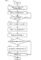
図3を参照すると、方法(又はプロセス)200が示されている。方法200は、モジュール100の補正部分の動作であってもよい。方法200は全体として、工程(又は状態)202、工程(又は状態)204、工程(又は状態)206、決定工程(又は状態)208、工程(又は状態)210、工程(又は状態)212、工程(又は状態)214、決定工程(又は状態)216、工程(又は状態)218、工程(又は状態)220、及び工程(又は状態)222を含む。
Referring to FIG. 3, a method (or process) 200 is shown.
工程202は、方法200の開始工程であってもよい。工程204は、無線ネットワーク54及び/又はGPS衛星56に接続してもよい。次に、工程206は、基準デバイス(例えば、モジュール100a〜100nのうちの静止しているもの及び/又は基地局58)の位置を特定してもよい。次に、決定工程208は、基準デバイスの位置が特定されている(例えば、モジュール100a〜100nのうちの静止しているもの及び/又は基地局58が範囲内にある)かどうかを決定する。特定されていない場合、方法200は工程206に戻る。特定されている場合、方法200は工程210に進む。
Step 202 may be the starting step of
工程210は、基準デバイスから識別コード(例えば、ID番号120b)を取得してもよい。次に、工程212は、基準デバイスから補正値120dを取得してもよい。次に、工程214は、取得した補正値120dに品質検査を実施する。
Step 210 may obtain an identification code (eg,
次に、決定工程216は、補正値が品質検査に合格するかどうかを決定する。合格しない場合、方法200は工程220に進む(例えば、補正値120dなしにGPSデータを発行し、補正フラグの値に基づいて補正されていないとしてGPSデータに印を付ける)。合格する場合、方法200は工程218に進む。工程218は、補正値を使用して局所的条件を補償する。次に、工程220は、車両52の位置を(例えば、記憶された位置座標120a及び/又は補正値120dに基づいて)決定する。次に、工程222は方法200を終了する。
Next, a determining
補正値120dの品質検査は、基準デバイスによって提供される車両位置データ112に基づいてもよい。いくつかの実施形態では、モジュール100は、固定基地局58に接続してもよい。固定基地局58からの位置データは、正しいもの(例えば、品質検査に合格する)と見なしてもよい。いくつかの実施形態では、モジュール100aは、車両52b〜52n内のモジュール100b〜100nのうちで、基準デバイスモードで動作している他のモジュールに接続してもよい。モジュール100aは、他のモジュール100b〜100nからの車両位置データ112を検査してもよい(例えば、品質検査を実施する)。例えば、品質検査は、モジュール100aから他のモジュール100b〜100nまでの最小許容距離(例えば、位置座標120a)に基づいてもよい。他の実施例では、品質検査は、他のモジュール100b〜100nのタイムスタンプ100cに基づいてもよい。タイムスタンプ100cが所定の閾値より古い場合、他のモジュール100b〜100nによって提供された補正データ120dは、使用するには古すぎる可能性がある(例えば、信頼性が低いと見なされる)。データが品質検査に合格するかどうかを判断するために検査されるデータのタイプ及び/又は使用される閾値は、特定の実装の設計基準に従って変更されてもよい。
The quality inspection of the
図4を参照すると、方法(又はプロセス)300が示されている。方法300は、モジュール100の計算部分の動作であってもよい。方法300は全体として、工程(又は状態)302、工程(又は状態)304、工程(又は状態)306、決定工程(又は状態)308、工程(又は状態)310、工程(又は状態)312、工程(又は状態)314、工程(又は状態)316、工程(又は状態)318、及び工程(又は状態)320を含む。工程302は、方法300の開始工程であってもよい。工程304は、モジュール100がネットワーク54にアクセスすることを可能にしてもよい。次に、工程306は、(例えば、GPS衛星58からの)GPSデータを決定してもよい。次に、決定工程308は、車両52が移動中かどうかを決定してもよい。
Referring to FIG. 4, a method (or process) 300 is shown.
決定工程308で車両52が移動中でないと決定される場合、方法300は状態310に進む。状態310は、改良データ(例えば、補正値120d)を計算してもよい。次に、工程314は、改良データをネットワーク54に提供する。その後、方法300は工程320に進み、この工程は方法300を終了する。決定工程308で車両が移動中であると決定される場合、方法300は工程312に進む。工程312は、車両位置データ(例えば、位置座標120a)を取得する。次に、工程316は、改良データ120dを取得する。次に、工程318は、車両位置決定のためのリアルタイム精度補正を(例えば、車両位置データ112の精度を向上させるために)計算する。次に、方法300は終了工程320に進んでもよい。
If the
モジュール100a〜100nは、位置データ(例えば、それぞれの車両52a〜52nの位置)を計算するように構成されてもよい。位置データの計算は、位置座標120a及び/又は座標値120dに基づいてもよい。プロセッサ102は、位置データを決定するための計算を実行するように構成されてもよい。例えば、アンテナ104は、複数のGPS衛星に接続するように構成されてもよい。他の実施例では、モジュール100a〜100nは、複数のGPS衛星に接続するために個別のアンテナを実装してもよい。アンテナ104は、GPS衛星からデータを受信してもよく、位置座標120aを決定するために計算を実施してもよい。局所的条件に起因する干渉が推定されてもよい。補正値120dは、局所的条件に起因する推定干渉をキャンセルするために使用されてもよい。いくつかの実施形態では、複数の基準デバイスからの改良データが検査されてもよい。モジュール100a〜100nは、受信された様々な改良データをテストし、最も正確な推定値を決定してもよい。最も正確になるように決定された改良データは、補正値120dとして使用されてもよい。
図5を参照すると、方法(又はプロセス)400が示されている。方法400は、モジュール100のネットワーク接続部分の動作であってもよい。方法400は全体として、工程(又は状態)402、工程(又は状態)404、決定工程(又は状態)406、工程(又は状態)408、工程(又は状態)410、工程(又は状態)412、決定工程(又は状態)414、工程(又は状態)416、決定工程(又は状態)418、工程(又は状態)420、及び工程(又は状態)422を含む。工程402は、方法400の開始工程であってもよい。工程404は、接続するモジュール(例えば、モジュール100a〜100nのうちの1つ)を探索してもよい。次に、方法400は決定工程406に進んでもよい。
Referring to FIG. 5, a method (or process) 400 is shown.
決定工程406は、検知されたモジュールがあるかどうかを決定する。検知されたモジュールがない場合、方法400は工程404に戻る。検知されたモジュールがある場合、方法400は工程408に進む。工程408は、新しいモジュール(例えば、モジュール100a〜100nのうちの1つ)をネットワーク54に追加する。次に、工程410は、モジュールから位置データ情報(例えば、位置座標120a)を取得する。次に、工程412は、モジュールの改良データを決定する。次に、方法400は決定工程414に進んでもよい。
A
決定工程414は、ネットワーク54に接続されているモジュールが他にあるかどうかを決定する。モジュールが他にない場合、方法400は工程416に進む。工程416は、改良データをモジュールに送信する。その後、方法400は、終了工程422に進む。ネットワーク54に接続されているモジュールが他にあると決定工程414が決定した場合、方法400は決定工程418に進む。
決定工程418は、より多くの補正値セットの使用が精度を改善するかどうかを決定する。改善しない場合、方法400は工程416に進む。例えば、モジュール100bがモジュール100cと同じ補正値を提供する場合、追加の補正値は、改良データの精度を改善しない可能性がある。より多くの補正値セットの使用が精度を改善すると決定工程418が決定した場合、方法400は工程420に進んでもよい。工程420は、改良データの精度を調整する。次に、方法400は工程416に進む。
The
図6を参照すると、方法(又はプロセス)500が示されている。方法500は補正値を計算してもよい。方法500は全体として、工程(又は状態)502、工程(又は状態)504、工程(又は状態)506、工程(又は状態)508、工程(又は状態)510、決定工程(又は状態)512、工程(又は状態)514、工程(又は状態)516、工程(又は状態)518、及び工程(又は状態)520を含む。
Referring to FIG. 6, a method (or process) 500 is shown.
工程502は、方法500の開始工程であってもよい。次に、工程504は、GPSデータを(例えば、GPS衛星56から)受信してもよい。次に、工程506は、フィルタ114を使用して位置座標120aを計算してもよい。工程508は、位置座標120aの精度を推定してもよい。工程510は、アドホックネットワーク54で補正値120dを探索してもよい。次に、方法500は決定工程512に進んでもよい。
Step 502 may be the starting step of
決定工程512は、補正値120dが品質検査に合格するかどうかを決定してもよい。合格しない場合、方法500は工程514に進んでもよい。合格する場合、方法500は工程516に進んでもよい。工程514は、位置座標120aを補正フラグなしで電子バス70に伝達してもよい。次に、方法500は工程520で終了してもよい。工程516は、位置座標120aから補正値120dを差し引いてもよい。次に、工程518は、更新された位置座標120a及び補正フラグを電子バス70に伝達してもよい。次に、方法500は工程520で終了してもよい。
The determining
モジュール100aは、補正フラグを電子バス70に送信してもよい。補正フラグは、インジケータ(例えば、ビット、命令、信号など)として実装されてもよい。補正フラグは、位置座標120aが補正値120dを使用して補正されているかどうかを示してもよい。例えば、補正フラグが設定されている場合、モジュール100aによって伝達される位置座標120aを使用する他の構成要素は、位置座標120aが改善された精度を有する(例えば、補正値120dが適用されている)と見なしてもよい。他の実施例では、補正フラグが設定されていない場合、モジュール100aによって伝達される位置座標120aを使用する他の構成要素は、位置座標120aが改善された精度を有しない(例えば、補正値120dが適用されていない)と見なしてもよい。いくつかの実施形態では、特定の特徴は、補正フラグの状態に依存してもよく、補正フラグが設定されていない場合は特徴が無効にされてもよい。補正フラグの実装は、特定の実装の設計基準に従って変更されてもよい。
The
いくつかの実施形態では、モジュール100a〜100nは様々な場所に配置されてもよい。例えば、モジュール100a〜100nは基地局58に設置されてもよい。モジュール100a〜100nを配置することは、専有の測位ネットワークを構築するために使用されてもよい。モジュール100a〜100nは、既存の電源(例えば、携帯電話基地局内で利用可能な電源、街路灯の電源、各種ランドマークにある電源など)を使用することによって様々な場所で設置されてもよい。例えば、モジュール100a〜100nは、ボート内及び/又はブイ上に設置されると、水に対する改善された位置精度を提供してもよい。モジュール100a〜100nの配置は、特定の実装の設計基準に従って変更されてもよい。
In some embodiments, the
いくつかの実施形態では、モジュール100a〜100nは、品質検査に合格する補正値120dを取得することが不可能であってもよい。例えば、近隣のモジュール100a〜100n(例えば、基準デバイス)のいずれも信頼できる情報を提供することが不可能であってもよい(例えば、タイムスタンプ120cが古すぎる可能性がある)。他の実施例では、基準デバイスとなる近隣のモジュール100a〜100n又は固定基地局58が1つも存在しない可能性がある。品質検査に合格する補正値120dが1つも存在しない場合、モジュール100a〜100nは、GPSデータ(例えば、衛星56から取得した位置座標120a)を使用し続けてもよい。例えば、補正フラグは、位置座標120aと共に送信されるときに設定されなくてもよい。いくつかの実施形態では、品質検査に合格する補正値120dが1つも存在しない場合、モジュール100a〜100nは、位置精度に関する一部の機能(例えば、車両52a〜52nの機能)を抑止(例えば、シャットダウン、無効化)してもよい。例えば、自動運転は、安全な実行に必要な精度レベルが得られないことから使用不可能になってもよい。
In some embodiments, the
モジュール100a〜100nは、基準デバイスの機能を実施する(例えば、ネットワーク54のモジュール100a〜100nの補正値120dを計算する)ように構成されてもよく、及び/又は、位置データを決定する(例えば、位置を計算するために、GPS衛星56及び/又は補正値120dから位置座標120aを取得する)ように構成されてもよい。例えば、モジュール100a〜100nが静止している場合(例えば、車両52a〜52nが駐車状態及び/又はアイドリング状態である)、モジュール100a〜100nは基準デバイスの機能を実施してもよい。基準デバイスの機能を実施しているモジュール100a〜100nは、ネットワーク54内の他のモジュール100a〜100nの補正値120dを計算するように構成されてもよい。他の実施例では、モジュール100a〜100nが移動中の場合、モジュール100a〜100nは、衛星56から位置座標120aを取得し、及び/又は、ネットワーク54から補正値120dを受信して、精密な位置データを決定してもよい。
車両52a〜52nに配置されるモジュール(例えば、RTKタイプの受信機)100a〜100nは、ネットワーク54(例えば、クラウド、インターネット、無線システム、セルラーシステムなど)へのアクセスを提供してもよい。モジュール100a〜100nのそれぞれは、位置座標120a、ID番号120b、データの経過時間(例えば、タイムスタンプ120cなど、データが最後に更新されたとき)、補正値120d、及び/又は他のデータ120nなどのような、位置及び/又はブロードキャストデータを計算するように構成されてもよい。モジュール100a〜100nのうちの1つが移動中でない場合、移動中でないモジュールは、改良されたデータ(例えば、補正値120d)を計算及び/又は提供してもよく、改良されたデータは、ネットワーク54上の他のモジュール100a〜100nによって使用されるように構成されている。
Modules (eg, RTK type receivers) 100a-100n located in
改良されたデータは、一定距離(例えば、典型的には最大15km)内の車両52a〜52nに対する位置精度の決定を支援する(例えば、リアルタイム精度補正を計算する)ために使用されてもよい。所定領域内により多くのモジュール100a〜100nが存在するほど、より優れた改良データの適用範囲及び/又はネットワーク54の形成がもたらされてもよい。例えば、車両52a〜52nは、ローカルメッシュネットワークを形成してもよく、これにより、広域ネットワーク(例えば、インターネット及び/又は特定のサービスプロバイダーのセルラーシステム)に接続することなく、車両位置データ112を共有する。車両52a〜52nのそれぞれは、モジュール(例えば、モジュール100a〜100nのうちの1つ)を有してもよく、モジュールは、車両52a〜52n内で及び/又はネットワーク54を介して使用する改良データを計算することができる。位置精度の改善レベルは、無線ネットワーク54上の任意の場所での補正データ120dの密度及び/又は品質に基づいてもよい。例えば、特定の距離範囲内でより多くのモジュール100a〜100nを有することにより、その特定の距離範囲内のモジュール100a〜100nのそれぞれに対する補正データの品質は改善してもよい。
The improved data may be used to assist in determining position accuracy (eg, calculating real-time accuracy corrections) for
モジュール100a〜100nを使用してもよく、これにより、GPS/GNSS衛星型システムの位置データの正確さを向上させる。モジュール100a〜100nは、固定基準デバイス(例えば、基地局58及び/又は基準デバイスとなる車両52a〜52nのうちの静止しているもの)からの位相波及び搬送波を使用するように構成されてもよく、これにより、リアルタイム補正及び/又は改良を提供して、位置ソリューションを決定する。
モジュール100a〜100nは、車両位置データ112を電子バス70に公開するように実装されてもよい。例えば、車両位置データ112は、ナビゲーション及び/又は自動緊急救急サービスなどの複数の構成要素で使用可能にされてもよい。車両位置データ112は、緯度、経度及び高度、対地速度情報、時間情報、及び/又は進行方向を含んでもよい。例えば、緊急呼び出し(例えば、eCall)がトリガされると(例えば、衝突の検知及び/又はエアバッグの展開による)、車両位置データ112が送信されてもよい。他の実施例では、車両位置データ112は、コンパス方位に変換され、電子バス70に公開されてもよい。コンパス方位及び/又は位置情報は、インフォテインメントモジュール及び/又はユーザーデバイスに表示されてもよい。
当業者には明らかであるように、図3〜図6で実施される機能は、本明細書の教示に従ってプログラムされた、従来の汎用プロセッサ、デジタルコンピュータ、マイクロプロセッサ、マイクロコントローラ、RISC(縮小命令セットコンピュータ)プロセッサ、CISC(複雑命令セットコンピュータ)プロセッサ、SIMD(単一命令多重データ)プロセッサ、信号プロセッサ、中央演算処理装置(CPU)、演算論理回路(ALU)、ビデオデジタル信号プロセッサ(VDSP)及び/又は類似の計算機のうちの1つ又は2つ以上を使用して実装されてもよい。同じく当業者には明らかであるように、適切なソフトウェア、ファームウェア、コード化、ルーチン、命令、オペコード、マイクロコード、及び/又はプログラムモジュールは、本開示の教示に基づいて習熟したプログラマによって容易に準備されてもよい。ソフトウェアは全体として、マシン実装のプロセッサのうちの1つ又は2つ以上によって、1つ又は複数の媒体から実行されてもよい。 As will be apparent to one of ordinary skill in the art, the functions implemented in FIGS. 3-6 may be any conventional general purpose processor, digital computer, microprocessor, microcontroller, RISC (reduced instruction) programmed according to the teachings herein. Set computer) processor, CISC (complex instruction set computer) processor, SIMD (single instruction multiple data) processor, signal processor, central processing unit (CPU), arithmetic logic circuit (ALU), video digital signal processor (VDSP) and And / or may be implemented using one or more of similar computers. Appropriate software, firmware, coding, routines, instructions, opcodes, microcode, and / or program modules are readily prepared by a skilled programmer in accordance with the teachings of the present disclosure, as will also be apparent to those skilled in the art. May be done. The software as a whole may be executed from one or more media by one or more of the machine-implemented processors.
本明細書に記載されているように、本発明はまた、ASIC(特定用途向け集積回路)、Platform ASIC、FPGA(フィールドプログラマブルゲートアレイ)、PLD(プログラマブル論理デバイス)、CPLD(複合プログラマブル論理デバイス)、シーオブゲート、RFIC(無線周波数用集積回路)、ASSP(特定業務用標準製品)、1つ若しくは2つ以上のモノリシック集積回路、1つ又は2つ以上のチップ、又はフリップチップモジュール及び/又はマルチチップモジュールとして配置されたダイの準備によって、あるいは、従来の構成要素回路の適切なネットワークを相互接続することによって実装されてもよく、その改良例は当業者には容易に明らかになるだろう。 As described herein, the present invention also includes ASICs (Application Specific Integrated Circuits), Platform ASICs, FPGAs (Field Programmable Gate Arrays), PLDs (Programmable Logic Devices), CPLDs (Complex Programmable Logic Devices). , Sea of Gate, RFIC (Radio Frequency Integrated Circuit), ASSP (Standard Products for Specific Business Use), one or more monolithic integrated circuits, one or more chips, or flip chip modules and / or It may be implemented by preparation of the die arranged as a multi-chip module or by interconnecting a suitable network of conventional component circuits, modifications of which will be readily apparent to those skilled in the art. .
このように、本発明はまた、本発明に従って1つ又は2つ以上のプロセス又は方法を実施するように、マシンをプログラムするために使用され得る命令を含む、1つ又は2つ以上の記憶媒体及び/又は1つ若しくは2つ以上の送信媒体であり得るコンピュータ製品を含んでもよい。周辺回路の動作に加えて、マシンによるコンピュータ製品に含まれる命令の実行は、入力データを、記憶媒体上の1つ又は2つ以上のファイル、及び/又は、聴覚及び/若しくは視覚的描写などの物理対象又は実体を表す1つ又は2つ以上の出力信号に変換してもよい。記憶媒体としては、限定するものではないが、フロッピーディスク、ハードドライブ、磁気ディスク、光ディスク、CD−ROM、DVD、及び光磁気ディスクを含む任意のタイプのディスク、及びROM(読み取り専用メモリ)、RAM(ランダムアクセスメモリ)、EPROM(消去可能プログラマブルROM)、EEPROM(電気的消去可能プログラマブルROM)、UVPROM(紫外線消去型プログラマブルROM)、フラッシュメモリ、磁気カード、光カード、及び/又は電子命令の記憶に適した任意のタイプの媒体などの回路を含んでもよい。 Thus, the present invention also includes one or more storage media that include instructions that may be used to program a machine to perform one or more processes or methods in accordance with the present invention. And / or may include a computer product, which may be one or more transmission media. In addition to the operation of peripheral circuitry, execution of instructions by a machine contained in a computer product may cause input data to include input data such as one or more files on a storage medium and / or an audio and / or visual depiction. It may be converted into one or more output signals representing a physical object or entity. The storage medium includes, but is not limited to, any type of disk including floppy disk, hard drive, magnetic disk, optical disk, CD-ROM, DVD, and magneto-optical disk, ROM (read-only memory), RAM. (Random access memory), EPROM (erasable programmable ROM), EEPROM (electrically erasable programmable ROM), UVPROM (ultraviolet erasable programmable ROM), flash memory, magnetic card, optical card, and / or storage of electronic instructions Circuitry, such as any suitable type of medium, may be included.
本発明の要素は、1つ又は2つ以上のデバイス、ユニット、コンポーネント、システム、マシン、及び/又は装置の一部又は全部を形成してもよい。装置としては、限定するものではないが、サーバ、ワークステーション、ストレージアレイコントローラ、ストレージシステム、パーソナルコンピュータ、ラップトップコンピュータ、ノートブックコンピュータ、パームコンピュータ、パーソナルデジタルアシスタント、ポータブル電子デバイス、バッテリ駆動デバイス、セットトップボックス、エンコーダ、デコーダ、トランスコーダ、圧縮器、減圧器、プリプロセッサ、ポストプロセッサ、送信機、受信機、トランシーバ、暗号回路、携帯電話、デジタルカメラ、位置決定及び/又はナビゲーションシステム、医療機器、ヘッドアップディスプレイ、無線デバイス、音声記録、音声記憶及び/又は音声再生デバイス、ビデオ録画、ビデオ記憶、及び/又はビデオ再生デバイス、ゲームプラットフォーム、周辺機器、及び/又はマルチチップモジュールを含んでもよい。本発明の要素は、特定の用途の基準に合わせて他のタイプの装置に実装されてもよいことを、当業者は理解するであろう。 Elements of the invention may form part or all of one or more devices, units, components, systems, machines, and / or apparatus. Devices include, but are not limited to, servers, workstations, storage array controllers, storage systems, personal computers, laptop computers, notebook computers, palm computers, personal digital assistants, portable electronic devices, battery powered devices, sets. Top boxes, encoders, decoders, transcoders, compressors, pressure reducers, preprocessors, postprocessors, transmitters, receivers, transceivers, cryptographic circuits, mobile phones, digital cameras, position determination and / or navigation systems, medical devices, heads Up-display, wireless device, audio recording, audio storage and / or audio playback device, video recording, video storage and / or video playback device, game player -Platform may comprise peripherals, and / or a multichip module. Those skilled in the art will appreciate that the elements of the present invention may be implemented in other types of devices to meet the criteria of a particular application.
本発明はその好ましい実施形態を参照して特に示され説明されているが、当業者であれば、本発明の範囲を逸脱することなく、形態及び詳細の様々な変更が加えられてもよいことを理解するであろう。 While the invention has been particularly shown and described with reference to its preferred embodiments, those skilled in the art may make various changes in form and detail without departing from the scope of the invention. Will understand.
Claims (11)
命令を実行するように構成されているプロセッサと、
前記命令を記憶するように構成されているメモリと、を備えた装置であって、
前記命令は、実行時に、(i)前記無線ネットワークに接続されている基準デバイスの位置を特定する工程であって、前記基準デバイスが(a)識別コード及び(b)補正値を有する工程と、(ii)前記補正値が品質検査に合格するかどうかを決定する工程と、(iii)前記補正値が前記品質検査に合格する場合、前記GPS衛星に接続したときに前記補正値を使用して局所的条件を補償する工程と、を実施し、
前記品質検査は、前記基準デバイスの位置及び前記補正値の更新後の経過時間を検査することを備え、
前記装置は、前記位置が最小許容距離を下回るとき、および/または、前記補正値の前記更新後の前記経過時間が所定の閾値を下回るとき、前記補正値を使用し、
前記装置は、前記補正値が前記品質検査で不合格になる場合、前記GPS衛星から受信したGPSデータを使用し続けることを特徴とする装置。 (I) an antenna configured to connect to a wireless network and (ii) GPS satellites;
A processor configured to execute the instructions,
A device and a memory configured to store the instructions,
The instruction is, when executed, (i) locating a reference device connected to the wireless network, the reference device having (a) an identification code and (b) a correction value; (Ii) determining whether the correction value passes a quality inspection, and (iii) using the correction value when connecting to the GPS satellite if the correction value passes the quality inspection. Compensating for local conditions, and
The quality inspection comprises inspecting a position of the reference device and an elapsed time after updating the correction value,
The device uses the correction value when the position is below a minimum allowable distance and / or when the elapsed time after the update of the correction value is below a predetermined threshold,
The device continues to use GPS data received from the GPS satellites if the correction value fails the quality check.
Applications Claiming Priority (3)
| Application Number | Priority Date | Filing Date | Title |
|---|---|---|---|
| US14/674,836 | 2015-03-31 | ||
| US14/674,836 US20160291164A1 (en) | 2015-03-31 | 2015-03-31 | Automotive ad hoc real time kinematics roving network |
| PCT/US2016/023949 WO2016160497A1 (en) | 2015-03-31 | 2016-03-24 | Automotive ad hoc real time kinematics roving network |
Publications (3)
| Publication Number | Publication Date |
|---|---|
| JP2018513370A JP2018513370A (en) | 2018-05-24 |
| JP2018513370A5 JP2018513370A5 (en) | 2018-11-29 |
| JP6684821B2 true JP6684821B2 (en) | 2020-04-22 |
Family
ID=57007527
Family Applications (1)
| Application Number | Title | Priority Date | Filing Date |
|---|---|---|---|
| JP2017551305A Active JP6684821B2 (en) | 2015-03-31 | 2016-03-24 | Automotive Ad Hoc Real Time Kinematic Roving Network |
Country Status (5)
| Country | Link |
|---|---|
| US (1) | US20160291164A1 (en) |
| EP (1) | EP3243088B1 (en) |
| JP (1) | JP6684821B2 (en) |
| CN (1) | CN107430198B (en) |
| WO (1) | WO2016160497A1 (en) |
Families Citing this family (8)
| Publication number | Priority date | Publication date | Assignee | Title |
|---|---|---|---|---|
| WO2017122253A1 (en) * | 2016-01-15 | 2017-07-20 | パナソニックIpマネジメント株式会社 | Gnss correction data distribution device, gnss correction data distribution system, and gnss correction data distribution method |
| GB2553141B (en) | 2016-08-26 | 2019-12-11 | Raytheon Systems Ltd | Method and apparatus for position estimation |
| US10551504B2 (en) | 2016-10-04 | 2020-02-04 | Trimble Inc. | Method and system for sharing convergence data |
| US10406972B2 (en) | 2017-02-24 | 2019-09-10 | Tesla, Inc. | Vehicle technologies for automated turn signaling |
| US10534092B2 (en) * | 2017-06-01 | 2020-01-14 | Tesla, Inc. | Technologies for vehicle positioning |
| CN109991632B (en) * | 2017-12-29 | 2023-10-24 | 沃尔沃汽车公司 | Positioning system and method |
| CN113286212B (en) * | 2021-05-20 | 2022-07-12 | 北京明略软件系统有限公司 | Wearing type audio acquisition assembly |
| IL286034B2 (en) * | 2021-09-01 | 2023-10-01 | Israel Aerospace Ind Ltd | Vehicle navigation combining transmitted object location information and sensor-based relative object location information |
Family Cites Families (17)
| Publication number | Priority date | Publication date | Assignee | Title |
|---|---|---|---|---|
| US5748651A (en) * | 1995-05-05 | 1998-05-05 | Trumble Navigation Limited | Optimum utilization of pseudorange and range rate corrections by SATPS receiver |
| US7110880B2 (en) * | 1997-10-22 | 2006-09-19 | Intelligent Technologies International, Inc. | Communication method and arrangement |
| US6002363A (en) * | 1996-03-08 | 1999-12-14 | Snaptrack, Inc. | Combined GPS positioning system and communications system utilizing shared circuitry |
| DE19624719A1 (en) * | 1996-06-21 | 1998-01-02 | Claas Ohg | System for determining the position of mobile objects, in particular vehicles |
| US5884220A (en) * | 1996-07-16 | 1999-03-16 | Trimble Navigation Limited | Method and apparatus to improve overall performance of a DGPS receiver |
| US6111541A (en) * | 1997-05-09 | 2000-08-29 | Sony Corporation | Positioning system using packet radio to provide differential global positioning satellite corrections and information relative to a position |
| AU2003299112A1 (en) * | 2002-09-25 | 2004-04-19 | John Fagan | Laas navigation system |
| DE602004032557D1 (en) * | 2003-10-06 | 2011-06-16 | Insitu Inc | METHOD AND DEVICE FOR SATELLITE-BASED RELATIVE POSITIONING OF MOBILE PLATFORMS |
| JP4853490B2 (en) * | 2008-04-25 | 2012-01-11 | トヨタ自動車株式会社 | Inter-mobile interference positioning system, apparatus and method |
| US20110039578A1 (en) * | 2009-08-14 | 2011-02-17 | Qualcomm Incorporated | Assistance data for positioning in multiple radio access technologies |
| US20110130906A1 (en) * | 2009-12-01 | 2011-06-02 | Ise Corporation | Location Based Vehicle Data Logging and Diagnostic System and Method |
| US20110181465A1 (en) * | 2010-01-26 | 2011-07-28 | Rongsheng Li | Multi-constellation global navigation satellite system augmentation and assistance |
| US8983685B2 (en) * | 2010-07-30 | 2015-03-17 | Deere & Company | System and method for moving-base RTK measurements |
| WO2013123057A1 (en) * | 2012-02-13 | 2013-08-22 | Intertrust Technologies Corporation | Trusted connected vehicle systems and methods |
| DE102013001120B4 (en) * | 2013-01-23 | 2015-08-13 | Audi Ag | Method and system for operating motor vehicles connected via vehicle-to-vehicle communication |
| JP2014153193A (en) * | 2013-02-08 | 2014-08-25 | Sumitomo Electric Ind Ltd | Positioning system, indoor transmitter, reference station device and mobile terminal |
| US9020755B1 (en) * | 2013-12-17 | 2015-04-28 | GM Global Technology Operations LLC | AD-HOC differential GPS referencing using parked vehicles |
-
2015
- 2015-03-31 US US14/674,836 patent/US20160291164A1/en not_active Abandoned
-
2016
- 2016-03-24 WO PCT/US2016/023949 patent/WO2016160497A1/en active Application Filing
- 2016-03-24 CN CN201680020509.XA patent/CN107430198B/en active Active
- 2016-03-24 EP EP16773789.9A patent/EP3243088B1/en active Active
- 2016-03-24 JP JP2017551305A patent/JP6684821B2/en active Active
Also Published As
| Publication number | Publication date |
|---|---|
| JP2018513370A (en) | 2018-05-24 |
| WO2016160497A1 (en) | 2016-10-06 |
| EP3243088B1 (en) | 2020-12-30 |
| CN107430198A (en) | 2017-12-01 |
| CN107430198B (en) | 2021-07-20 |
| EP3243088A1 (en) | 2017-11-15 |
| EP3243088A4 (en) | 2018-07-25 |
| US20160291164A1 (en) | 2016-10-06 |
Similar Documents
| Publication | Publication Date | Title |
|---|---|---|
| JP6684821B2 (en) | Automotive Ad Hoc Real Time Kinematic Roving Network | |
| JP2018520335A (en) | GNSS real-time kinematic dead reckoning receiver for automobile | |
| US11092696B2 (en) | Grouping for efficient cooperative positioning calculations | |
| US11422253B2 (en) | Method and system for positioning using tightly coupled radar, motion sensors and map information | |
| US11506512B2 (en) | Method and system using tightly coupled radar positioning to improve map performance | |
| JP2018513370A5 (en) | ||
| US20180106906A1 (en) | Positioning processing system, method, computer program, positioning processing device, and user terminal | |
| US9766348B2 (en) | GNSS architecture | |
| US9952330B2 (en) | Automotive dead reckoning with dynamic calibration and/or dynamic weighting | |
| WO2015035501A1 (en) | System and method for enhanced integrated navigation with wireless angle of arrival | |
| US20110012779A1 (en) | Method and system for a virtual wide area gnss reference network | |
| JP2021009109A (en) | Positioning method, positioning system, control device, and mobile station | |
| US20100094554A1 (en) | Systems and Methods for Accessing Data Over a Short-range Data Link to Enhance the Performance of a Navigational Unit | |
| CN112904390B (en) | Positioning method, positioning device, computer equipment and storage medium | |
| WO2020008791A1 (en) | Positioning system, positioning device and center device | |
| EP3259609B1 (en) | Providing an indication of a heading of a mobile device | |
| US10469982B2 (en) | System and method for enhanced integrated navigation with wireless angle of arrival | |
| US20230127310A1 (en) | Method and apparatus for detecting multipath signals from a navigation satellite | |
| CN115585807B (en) | GNSS/INS integrated navigation method based on machine learning | |
| US20240111060A1 (en) | Mobility and Control Method Thereof | |
| Arslan et al. | An Embedded Vehicle Tracking Application with Dead Reckoning and Assisted Global Positioning Methods | |
| CN114966776A (en) | Positioning method, positioning device, electronic equipment and computer storage medium |
Legal Events
| Date | Code | Title | Description |
|---|---|---|---|
| A521 | Request for written amendment filed |
Free format text: JAPANESE INTERMEDIATE CODE: A523 Effective date: 20171117 |
|
| A621 | Written request for application examination |
Free format text: JAPANESE INTERMEDIATE CODE: A621 Effective date: 20171117 |
|
| A711 | Notification of change in applicant |
Free format text: JAPANESE INTERMEDIATE CODE: A711 Effective date: 20180704 |
|
| A711 | Notification of change in applicant |
Free format text: JAPANESE INTERMEDIATE CODE: A711 Effective date: 20180820 |
|
| A521 | Request for written amendment filed |
Free format text: JAPANESE INTERMEDIATE CODE: A523 Effective date: 20181019 |
|
| A131 | Notification of reasons for refusal |
Free format text: JAPANESE INTERMEDIATE CODE: A131 Effective date: 20181211 |
|
| A521 | Request for written amendment filed |
Free format text: JAPANESE INTERMEDIATE CODE: A523 Effective date: 20190305 |
|
| A131 | Notification of reasons for refusal |
Free format text: JAPANESE INTERMEDIATE CODE: A131 Effective date: 20190827 |
|
| A521 | Request for written amendment filed |
Free format text: JAPANESE INTERMEDIATE CODE: A523 Effective date: 20191126 |
|
| TRDD | Decision of grant or rejection written | ||
| A01 | Written decision to grant a patent or to grant a registration (utility model) |
Free format text: JAPANESE INTERMEDIATE CODE: A01 Effective date: 20200303 |
|
| A61 | First payment of annual fees (during grant procedure) |
Free format text: JAPANESE INTERMEDIATE CODE: A61 Effective date: 20200330 |
|
| R150 | Certificate of patent or registration of utility model |
Ref document number: 6684821 Country of ref document: JP Free format text: JAPANESE INTERMEDIATE CODE: R150 |
|
| R250 | Receipt of annual fees |
Free format text: JAPANESE INTERMEDIATE CODE: R250 |
|
| S111 | Request for change of ownership or part of ownership |
Free format text: JAPANESE INTERMEDIATE CODE: R313113 |
|
| S531 | Written request for registration of change of domicile |
Free format text: JAPANESE INTERMEDIATE CODE: R313531 |
|
| R350 | Written notification of registration of transfer |
Free format text: JAPANESE INTERMEDIATE CODE: R350 |