JP6489003B2 - Route search device and vehicle automatic driving device - Google Patents
Route search device and vehicle automatic driving device Download PDFInfo
- Publication number
- JP6489003B2 JP6489003B2 JP2015243145A JP2015243145A JP6489003B2 JP 6489003 B2 JP6489003 B2 JP 6489003B2 JP 2015243145 A JP2015243145 A JP 2015243145A JP 2015243145 A JP2015243145 A JP 2015243145A JP 6489003 B2 JP6489003 B2 JP 6489003B2
- Authority
- JP
- Japan
- Prior art keywords
- route
- temporary
- unit
- destination
- current location
- Prior art date
- Legal status (The legal status is an assumption and is not a legal conclusion. Google has not performed a legal analysis and makes no representation as to the accuracy of the status listed.)
- Active
Links
- 238000012544 monitoring process Methods 0.000 claims description 12
- 230000010365 information processing Effects 0.000 description 12
- 230000006870 function Effects 0.000 description 8
- 238000000034 method Methods 0.000 description 7
- 238000012545 processing Methods 0.000 description 4
- 230000005540 biological transmission Effects 0.000 description 3
- 230000001133 acceleration Effects 0.000 description 2
- 230000006399 behavior Effects 0.000 description 2
- 238000004891 communication Methods 0.000 description 2
- 238000001514 detection method Methods 0.000 description 2
- 238000010586 diagram Methods 0.000 description 1
- 238000005516 engineering process Methods 0.000 description 1
- 239000000446 fuel Substances 0.000 description 1
- 238000002347 injection Methods 0.000 description 1
- 239000007924 injection Substances 0.000 description 1
- 230000009191 jumping Effects 0.000 description 1
- 230000002265 prevention Effects 0.000 description 1
- 238000005096 rolling process Methods 0.000 description 1
- 230000005236 sound signal Effects 0.000 description 1
Images


Classifications
-
- G—PHYSICS
- G01—MEASURING; TESTING
- G01C—MEASURING DISTANCES, LEVELS OR BEARINGS; SURVEYING; NAVIGATION; GYROSCOPIC INSTRUMENTS; PHOTOGRAMMETRY OR VIDEOGRAMMETRY
- G01C21/00—Navigation; Navigational instruments not provided for in groups G01C1/00 - G01C19/00
- G01C21/26—Navigation; Navigational instruments not provided for in groups G01C1/00 - G01C19/00 specially adapted for navigation in a road network
- G01C21/34—Route searching; Route guidance
- G01C21/3407—Route searching; Route guidance specially adapted for specific applications
- G01C21/3415—Dynamic re-routing, e.g. recalculating the route when the user deviates from calculated route or after detecting real-time traffic data or accidents
-
- G—PHYSICS
- G08—SIGNALLING
- G08G—TRAFFIC CONTROL SYSTEMS
- G08G1/00—Traffic control systems for road vehicles
- G08G1/09—Arrangements for giving variable traffic instructions
- G08G1/0962—Arrangements for giving variable traffic instructions having an indicator mounted inside the vehicle, e.g. giving voice messages
- G08G1/0968—Systems involving transmission of navigation instructions to the vehicle
- G08G1/0969—Systems involving transmission of navigation instructions to the vehicle having a display in the form of a map
-
- G—PHYSICS
- G01—MEASURING; TESTING
- G01C—MEASURING DISTANCES, LEVELS OR BEARINGS; SURVEYING; NAVIGATION; GYROSCOPIC INSTRUMENTS; PHOTOGRAMMETRY OR VIDEOGRAMMETRY
- G01C21/00—Navigation; Navigational instruments not provided for in groups G01C1/00 - G01C19/00
- G01C21/26—Navigation; Navigational instruments not provided for in groups G01C1/00 - G01C19/00 specially adapted for navigation in a road network
- G01C21/34—Route searching; Route guidance
-
- G—PHYSICS
- G05—CONTROLLING; REGULATING
- G05D—SYSTEMS FOR CONTROLLING OR REGULATING NON-ELECTRIC VARIABLES
- G05D1/00—Control of position, course or altitude of land, water, air, or space vehicles, e.g. automatic pilot
- G05D1/02—Control of position or course in two dimensions
- G05D1/021—Control of position or course in two dimensions specially adapted to land vehicles
- G05D1/0212—Control of position or course in two dimensions specially adapted to land vehicles with means for defining a desired trajectory
-
- G—PHYSICS
- G08—SIGNALLING
- G08G—TRAFFIC CONTROL SYSTEMS
- G08G1/00—Traffic control systems for road vehicles
- G08G1/09—Arrangements for giving variable traffic instructions
- G08G1/0962—Arrangements for giving variable traffic instructions having an indicator mounted inside the vehicle, e.g. giving voice messages
- G08G1/0968—Systems involving transmission of navigation instructions to the vehicle
- G08G1/096833—Systems involving transmission of navigation instructions to the vehicle where different aspects are considered when computing the route
- G08G1/096844—Systems involving transmission of navigation instructions to the vehicle where different aspects are considered when computing the route where the complete route is dynamically recomputed based on new data
-
- G—PHYSICS
- G09—EDUCATION; CRYPTOGRAPHY; DISPLAY; ADVERTISING; SEALS
- G09B—EDUCATIONAL OR DEMONSTRATION APPLIANCES; APPLIANCES FOR TEACHING, OR COMMUNICATING WITH, THE BLIND, DEAF OR MUTE; MODELS; PLANETARIA; GLOBES; MAPS; DIAGRAMS
- G09B29/00—Maps; Plans; Charts; Diagrams, e.g. route diagram
- G09B29/10—Map spot or coordinate position indicators; Map reading aids
- G09B29/106—Map spot or coordinate position indicators; Map reading aids using electronic means
Description
本発明は経路探索装置及び車両用自動運転装置に関する。 The present invention relates to a route search device and an automatic driving device for a vehicle.
自動運転システムにより車両を自動運転制御するには、予め設定された経路を追従するように制御する必要がある。自動運転システムに経路を設定するには、ユーザが例えばナビゲーションシステムに目的地を設定すると、ナビゲーションシステムが現在地から目的地までの経路を探索することにより得られた経路情報を自動運転システムに通知するので、自動運転システムは経路を設定することができる。経路情報とは、例えば道路の形状情報、道路リンクID、分岐点での分岐方向等である。自動運転システムは、システムに内蔵されている自動運転用の詳細な地図データを参照しながら、車両に備えられた各種監視センサを用いて車両周囲の状況を監視することで走路前方の道路形状を認識する。このように道路形状を認識することにより、自動運転システムは、安全を確保しつつ最適な車速や走路を逐次選択して自動運転制御を実行することができる。 In order to automatically control the vehicle by the automatic driving system, it is necessary to control the vehicle so as to follow a preset route. To set a route in the automatic driving system, for example, when a user sets a destination in the navigation system, the navigation system notifies the automatic driving system of route information obtained by searching for a route from the current location to the destination. Therefore, the automatic driving system can set a route. The route information includes, for example, road shape information, road link ID, branch direction at a branch point, and the like. The automatic driving system refers to the detailed map data for automatic driving built in the system, and monitors the situation around the vehicle by using various monitoring sensors provided in the vehicle, so that the shape of the road ahead of the runway is determined. recognize. By recognizing the road shape in this way, the automatic driving system can execute automatic driving control by sequentially selecting the optimum vehicle speed and traveling path while ensuring safety.
尚、ナビゲーションシステムが例えば道路交通情報センタから道路交通状況を受信可能に構成されている場合には、経路情報は道路交通状況の変化に応じてナビゲーションシステムにより逐次更新されて適宜自動運転システムへ通知される。これにより、自動運転システムは、道路交通情報を反映しながら自動運転制御を実行することができる。 If the navigation system is configured to be able to receive road traffic conditions from, for example, the road traffic information center, the route information is updated sequentially by the navigation system according to changes in the road traffic conditions and appropriately notified to the automatic driving system. Is done. Thereby, the automatic driving system can execute the automatic driving control while reflecting the road traffic information.
ところで、車両が経路を追従するように自動運転制御の実行中に、例えば他車両の割り込み、歩行者の飛び出し、突発事故等の突発事象により走路が妨害されることがある。自動運転システムは、突発事象を車両に備えられた監視センサで認識して自動的に回避する。その結果、経路上は曲がろうとしていた交差点を曲がれなくなって直進したり、分岐点で本来分岐すべき道路から別の道路に分岐したりする等、経路を離脱してしまうことが想定される。 By the way, during the execution of the automatic driving control so that the vehicle follows the route, the runway may be obstructed by an unexpected event such as an interruption of another vehicle, a pedestrian jumping out, or a sudden accident. The automatic driving system automatically avoids an unexpected event by recognizing it by a monitoring sensor provided in the vehicle. As a result, it is assumed that the route will leave, such as going straight ahead at the intersection where it was going to bend, or branching from a road that should originally branch at a branch point to another road. .
経路を離脱した場合、ナビゲーションシステムが現在地から目的地までの新たな経路を探索するまでの間、自動運転システムは追従すべき経路が無い状態に陥る。一般的に現在地から目的地までの距離が遠いほど経路の探索には時間がかかり数秒から数十秒を要することから、自動運転システムは走行すべき経路が無い状態のまま自動運転制御を継続することになる。このため、所望の目的地とは異なる方向へ走行し続けてしまう恐れがある。 When the route leaves, the automatic driving system falls into a state where there is no route to follow until the navigation system searches for a new route from the current location to the destination. In general, the longer the distance from the current location to the destination, the longer it takes to search for a route, which takes several seconds to several tens of seconds. Therefore, the automatic driving system continues automatic driving control with no route to travel. It will be. For this reason, there exists a possibility of continuing driving | running | working in the direction different from a desired destination.
このように走行すべき経路が無い状態を回避するという観点では、危険を回避するために自動運転と手動運転を切り替える自動運転装置が提案されている(特許文献1参照)。
また、急なカーブ等でも緊急停止せず安全走行する手法(特許文献2参照)や緊急時に車両を停止させるまでの走行計画の立案手法(特許文献3参照)が提案されている。
From the viewpoint of avoiding a state where there is no route to travel in this way, an automatic driving device that switches between automatic driving and manual driving has been proposed in order to avoid danger (see Patent Document 1).
In addition, a method of safely driving without emergency stop even on a sharp curve (see Patent Document 2) and a method of planning a travel plan until the vehicle is stopped in an emergency (see Patent Document 3) have been proposed.
しかしながら、いずれの手法も危険回避行動によって車両が走行すべき経路を離脱した後も自動運転を継続することまでは言及していない。
また、ナビゲーションシステムが新たな経路を探索して自動運転システムに通知した時点では、新たな経路から既に離脱してしまっていることが想定される。このため、自動運転システムとナビゲーションシステムとをどのように連携させるかが問題となる。
However, neither method mentions that the automatic driving is continued even after the vehicle departs the route on which the vehicle should travel by the risk avoidance behavior.
In addition, when the navigation system searches for a new route and notifies the automatic driving system, it is assumed that the vehicle has already left the new route. For this reason, it becomes a problem how to link an automatic driving system and a navigation system.
本発明は上記事情に鑑みてなされたもので、その目的は、経路から離脱した場合に、経路が無い状態を短時間で解消することができる経路探索装置及び車両用自動運転装置を提供することにある。 The present invention has been made in view of the above circumstances, and an object of the present invention is to provide a route search device and an automatic driving device for a vehicle that can quickly eliminate a state where there is no route when the vehicle leaves the route. It is in.
請求項1の発明によれば、仮目的地設定部(54)は、経路から離脱した場合は第2記憶部(57)に記憶されている地図データに基づいて走行中の道路に沿った一定距離前方に仮目的地を設定する。すると、仮経路探索部(55)は、仮目的地までの仮経路を探索して経路として設定する。一方、経路探索部(27)は、仮目的地から真の目的地までの新たな経路を探索して仮経路の次の経路として設定する。 According to the first aspect of the present invention, the temporary destination setting unit (54), when leaving the route, is constant along the road on the basis of the map data stored in the second storage unit (57). Set a temporary destination ahead of the distance. Then, the temporary route search unit (55) searches for a temporary route to the temporary destination and sets it as a route. On the other hand, the route search unit (27) searches for a new route from the temporary destination to the true destination and sets it as the next route of the temporary route.
以下、本発明の一実施形態について図面を参照して説明する。
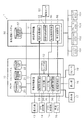
図1に示すように、車両用自動運転装置1は、ナビゲーションシステム(以下、ナビシステム)10と自動運転システム50とから構成されている。
Hereinafter, an embodiment of the present invention will be described with reference to the drawings.
As shown in FIG. 1, the vehicular automatic driving apparatus 1 includes a navigation system (hereinafter referred to as a navigation system) 10 and an
ナビシステム10は情報処理装置11を主体として構成されている。情報処理装置11は、ナビシステム10に内蔵されているセンサ部12からの情報に加えて、外部接続された通信機13、GPS受信機14、VICS(登録商標)受信機15、車速センサ16、操作部17からの情報に基づいて各種処理を実行する。
The
センサ部12は、車両に加えられる回転運動の大きさを検出するジャイロセンサ、3軸方向の加速度等から車両の走行距離を検出する加速度センサ、地磁気から車両の進行方向を検出する地磁気センサ等であり、GPS受信機14がGPS信号を受信できない状況となっても車両の現在地を特定可能となっている。
The
通信機13は、携帯基地局を介して交通情報センタから交通情報を受信し、広域範囲の渋滞情報や道路の規制情報等を情報処理装置11に出力する。
GPS受信機14は、GPS衛星からGPS電波を受信し、車両の現在地を特定するための位置情報を情報処理装置11に出力する。
The communication device 13 receives traffic information from the traffic information center via the mobile base station, and outputs traffic information on a wide area, road regulation information, and the like to the
The
VICS受信機15は、VICSセンタからの交通情報を受信し、車両の進行方向となる狭域範囲の道路交通情報や道路の規制情報を情報処理装置11に出力する。
車速センサ16は、車両の転動輪の回転速度から速度を検出し、その速度を示す速度信号を情報処理装置11に出力する。
The VICS
The
操作部17は、例えば表示部18と一体になったタッチパネルや表示部18の周囲に配置されたスイッチであり、それらに対する操作情報を情報処理装置11に出力する。
表示部18は、情報処理装置11から映像信号を入力し、車両の走行を案内するための地図、設定された目的地までの経路、当該目的地までの所要時間を示す画像等を表示する。
The
The
スピーカ19は、情報処理装置11から入力される音声信号が示す音声を出力する。例えば、経路が設定されている場合は、経路となる交差点での右左折方向や、経路となる分岐点で分岐方向を音声で出力する。
The
ナビシステム10にはデータベースが設けられている。データベースは、リンクコストデータベース(以下、リンクコストDB)20、交通情報データベース(以下、交通情報DB)21、経路案内地図データベース(以下、ナビ地図DB)22(第1記憶部に相当)から構成されている。
The
リンクコストDB20は、リンクコストを計算するために各ノード間のリンクコストを示すデータを記憶している。
交通情報DB21は、受信した交通情報に基づいて、渋滞の発生区間と渋滞度の程度を示すデータや交通規制の区間と交通規制の内容を示すデータを記憶している。
The link cost DB 20 stores data indicating the link cost between the nodes in order to calculate the link cost.
Based on the received traffic information, the traffic information DB 21 stores data indicating a section where a traffic jam occurs and the degree of traffic jam, and data indicating a traffic regulation section and the content of traffic regulation.
ナビ地図DB22は、地図表示のための地図データを記憶している。地図データには、位置精度向上のためのマップマッチングデータ、リンク(道路)及びノード(交差点、分岐点、インターチェンジ等)の位置情報やノードとリンクとの接続関係情報等を有する道路データ、施設の位置情報及びランドマークを有する施設データ等の各種データが含まれる。ナビ地図DB22は長距離経路探索を効率的に行うために道路ネットワークを階層化した構造となっている。つまり、上層ほど高速道や主要幹線道のみの粗い道路ネットワーク、下層ほど細街路等を含む詳細な道路ネットワークで構成されている。 The navigation map DB 22 stores map data for map display. Map data includes map matching data for improving location accuracy, road data including link (road) and node (intersections, branching points, interchanges, etc.) position information, node-link connection information, etc. Various data such as location information and facility data having landmarks are included. The navigation map DB 22 has a structure in which a road network is hierarchized in order to efficiently perform a long distance route search. That is, the upper layer is composed of a rough road network including only expressways and main trunk roads, and the lower layer is composed of a detailed road network including narrow streets.
情報処理装置11は、図示しないCPU、ROM、RAM、フラッシュメモリ等を備えるマイクロコンピュータにより構成されている。CPUは、ROMに記憶されたプログラムに従い、センサ部12、GPS受信機14、車速センサ16等からの各種信号、データベースに記憶されている情報、フラッシュメモリ等に記憶された情報等を用いて所定の演算を実行することによりナビゲーション機能を実現するための処理部を形成する。CPUが形成する処理部としては、車両の現在地を特定するための現在地特定部23、現在地特定部23が特定した現在地をナビ地図DB22に記憶されている地図データ上に特定するマップマッチング(以下、MM)部24、ユーザが表示部18上で目的地を設定したり、目的地までの経路や交通情報を表示部18に表示したりするユーザインタフェース(以下、UI)部25、外部から配信される交通情報を受信する交通情報受信部26、現在地から目的地までの経路を探索する経路探索部27から構成されている。
The
経路探索部27は、目的地が設定されると、現在地特定部23が特定した現在地と、ナビ地図DB22に記憶されている地図データに基づいて、周知のナビゲーション技術を用いて現在地から目的地までの最適な経路を求める経路計算を実行し、計算結果を位置参照情報として自動運転システム50に出力する。
When the destination is set, the
自動運転システム50は情報処理装置51を主体として構成されている。情報処理装置51は、図示しないCPU、ROM、RAM、フラッシュメモリ等を備えるマイクロコンピュータにより構成されている。CPUは、ROMに記憶されたプログラムに従い、ナビシステム10からの位置参照情報、監視センサ52からの信号、各種データベースに記憶されている情報、フラッシュメモリ等に記憶された情報等を用いて所定の演算を実行することにより自動運転制御機能を実現するための処理部を形成する。CPUが形成する処理部としては、ナビシステム10の現在地特定部23から車両の現在地を取得する現在地取得部53、走行中の道路に沿った一定距離前方に仮目的地を設定する仮目的地設定部54、現在地から仮目的地までの経路を探索する仮経路探索部55、監視センサ52からの情報を用いて車両を経路に追従して走行させる車両制御部56(経路識別部に相当)である。
The
監視センサ52は、車両の進行方向における道路レーンや障害物等を検出するための例えばレーダセンサや周囲監視カメラ等である。
レーダセンサは測距センサであり、ミリ波、レーザ光、超音波等の空中伝搬信号を車両の前方に設定された所定範囲の検出領域に出力し、当該検出領域に存在する障害物で反射した空中伝搬信号を受信する。空中伝搬信号を受信する方向に基づいて障害物の方向を検出可能となり、空中伝搬信号を出力してから受信するまでの時間に基づいて障害物までの距離を検出可能となる。尚、障害物の方向及び障害物までの距離を検出可能であれば、他の測距センサを用いるようにしても良い。
The
The radar sensor is a distance measuring sensor that outputs airborne signals such as millimeter waves, laser light, and ultrasonic waves to a detection area within a predetermined range set in front of the vehicle, and is reflected by an obstacle present in the detection area. Receive an airborne signal. The direction of the obstacle can be detected based on the direction in which the airborne signal is received, and the distance to the obstacle can be detected based on the time from the output of the airborne signal to reception. Other distance measuring sensors may be used as long as the direction of the obstacle and the distance to the obstacle can be detected.
周囲監視カメラは、車両の周辺を撮像した映像を映像認識技術により解析することで、走行中の道路レーンや、レーダセンサが検出した障害物である他車両、建物、通行者等を特定し、それらと車両との間の相対位置を示す相対位置情報を出力する。周囲監視カメラは車両の全周を撮像可能なように複数台設けることが望ましい。 The surrounding surveillance camera identifies the other vehicle, building, passerby, etc., which are obstacles detected by the radar sensor, by analyzing the image captured around the vehicle using video recognition technology, Relative position information indicating the relative position between them and the vehicle is output. It is desirable to provide a plurality of surrounding monitoring cameras so that the entire circumference of the vehicle can be imaged.
車両制御部56は、ナビシステム10から与えられた位置参照情報により経路を特定し、当該経路を追従するように自動運転制御を実行する。自動運転制御では、車両に搭載されているエンジンECU101、トランスミッションECU102、ブレーキECU103、ステアリングECU104等に指示信号を送信する。エンジンECU101はエンジンのスロットル開度、燃料噴射量、点火時期等を制御する。トランスミッションECU102は自動変速機の変速段等を制御する。ステアリングECU104は車両のステアリングの操舵角を制御する。ブレーキECU103はブレーキ圧、ABS機能、横滑り防止機能を制御する。
The
自動運転システム50には自動運転地図データベース(以下、自動運転地図DB)57(第2記憶部に相当)が設けられている。ナビ地図DB22と自動運転地図DB57は、例えば道路リンクID、道路の代表座標、分岐点の座標等の共通情報を用いることで、相互に位置参照可能に構成されている。
The
自動運転地図DB57は、道路の形状やレーン情報等の道路属性を保持する情報が記憶された地図DBであり、少なくとも道路間の接続情報や交通情報から特定した道路の規制情報等が格納されている。自動運転地図DB57は、走行中の道路形状やレーン情報の特定を主な目的とするため階層化はしておらず、詳細な道路ネットワーク情報に加え、道路や車線の幅員や白線の位置、道路構造物の3D形状を含む詳細な形状等の自動運転制御するために必要な情報を主に記憶している。自動運転地図DB57の短距離の経路探索機能はナビシステム10と同等で検索時間が長くなることはないが、一層構造のために長距離の経路探索機能はナビシステム10よりも大きく劣っている。
The automatic driving map DB 57 is a map DB storing information that holds road attributes such as road shape and lane information, and stores at least road connection information specified from road information and traffic regulation information. Yes. The automatic driving map DB 57 is not hierarchized for the main purpose of identifying the road shape and lane information during traveling, and in addition to detailed road network information, the width of the road and lane, the position of the white line, the road Information necessary for automatic operation control such as a detailed shape including the 3D shape of the structure is mainly stored. The short-distance route search function of the automatic driving map DB 57 is equivalent to the
仮目的地設定部54は、自動運転地図DB57に記憶されている道路情報に基づいて走行中の道路に沿った一定距離前方に仮目的地を設定する。一定距離は、ナビシステム10が仮目的地から真の目的地までの新たな経路を探索するのに要する時間で十分に走行可能な距離で、例えば300〜700mである。
The temporary
仮経路探索部55は、自動運転地図DB57に記憶されている道路情報に基づいて現在地から仮目的地までの仮経路を探索する。
車両制御部56は、経路探索部27から入力した経路やセンサ部12にて取得した相対位置情報に基づいて、周知のオートクルーズ機能やレーンキーピング機能を実現するための制御処理を実行する。例えば、車速が所定値を上回る状態ではオートクルーズ機能により先行車両に追従し、車速が所定値を下回ると、相対位置情報に基づいて隣接車線を走行する車両の走行速度と現在の走行速度とを比較し、隣接車線での走行速度の方が早い場合は車線変更する。
The temporary
Based on the route input from the
さて、ユーザがナビシステム10に目的地を設定すると、経路探索部27は、現在地から目的地までの適切な経路を交通情報を参照して探索することで経路情報を算出し、経路情報に対応した位置参照情報を自動運転システム50へ通知する。位置参照情報は、地図データにおけるリンク形式で表現される。通知方法は、現在地から近い範囲から順次通知しても良いし、すべての情報を一括で通知しても良い。
When the user sets a destination in the
自動運転システム50の車両制御部56は、通知された位置参照情報を自動運転地図DB57と照合し、自動運転地図DB57に記憶されている地図データに基づいて位置参照情報が示す経路を識別する。
The
ところで、自動運転システム50は、上述したように経路を識別した場合は、当該経路を追従するように自動運転制御するが、突発事象に対する危険回避行動により経路から離脱した場合は、ナビシステム10から新たな経路情報が通知されるまで経路が無い状態で自動運転制御することになる。また、ナビシステム10が新たな経路を探索して自動運転システム50に通知した時点では、新たな経路から既に離脱してしまっている事態が想定される。つまり、ナビシステム10により新たな経路を探索することで、自動運転システム50とナビシステム10との連携が難しくなる。
By the way, when the
このような事情から、本実施形態では、次のようにして自動運転システム50とナビシステム10との連携を図るようにした。
即ち、自動運転システム50は、図2に示すように、経路から離脱したかを監視しており(S101:NO)、離脱した場合(S101:YES)、車両制御部56へ直進自律制御を指示する(S102)。この直進自律制御とは、自動運転地図DB57に記憶されている地図データに基づいて経路が無い状態で車両を道なりとなる道路に追従するように自動運転制御するものである。道なりとなる道路とは、交差点に進入する場合は直進する道路、分岐点に進入する場合は車線が滑らかに接続して分岐角度がより直線に近い道路のことで、ステアリングを大きく操舵する必要がない道路のことである。自動運転地図DB57によっては道路ごとに道なり属性を保持しているものもある。
Under such circumstances, in the present embodiment, the
That is, as shown in FIG. 2, the
次に、現在地取得部53は、現在地特定部23から現在地を取得して仮目的地設定部54へ通知する(S103)。仮目的地設定部54は、現在地及び自動運転地図DB57に記憶されている地図データに基づいて道なりとなる道路を追跡し(S104)、当該道路に沿った位置に仮目的地を設定する(S105)。仮目的地を設定する位置は、図4に示すように、走行中の道路に対して道なりとなる道路上の一定距離前方となる位置である。
Next, the current
仮経路探索部55は、仮目的地と現在地を結ぶ仮経路を自動運転地図DB57に記憶されている地図データに基づいて探索し(S106)、その仮経路を車両制御部56へ通知する(S107)。これにより、車両制御部56は、直進自律制御を解除して仮経路を追従するように自動運転制御を行うようになる。この場合、仮目的地までの距離は短いので、仮経路探索部55は仮経路を短時間で探索することができる。
The temporary
図5に示すように、仮目的地までに道なりとなる道路を判別できない分岐点がある場合は、仮経路探索部55が仮経路を探索する時間が長くなることから、その分岐点を第1仮目的地に設定することで第1仮経路を短時間で探索すると共に、真の目的地に近い方となる分岐道路上に第2仮目的地に設定することで第2仮経路を短時間で探索する。これにより、車両制御部56は、第1仮経路を追従して走行することにより第1仮目的地に到達することができると共に第2仮経路を追従して走行することにより第2仮目的地に到達することができる。この場合、第2仮目的地が上述した仮目的地に相当する。
As shown in FIG. 5, when there is a branch point where the road that becomes the road to the temporary destination cannot be identified, the temporary
尚、仮目的地までに分岐点が複数存在する場合は、各分岐点が第1分岐点に設定されると共に各第1分岐点を結ぶ経路が第1仮経路に設定され、最後の第1分岐点から第2仮目的地までが第2仮経路に設定される。 When there are a plurality of branch points up to the temporary destination, each branch point is set as the first branch point, and a route connecting the first branch points is set as the first temporary route. From the branch point to the second temporary destination is set as the second temporary route.
自動運転システム50は、上述したようにして探索した仮経路の位置参照情報をナビシステム10のUI部25へ通知する(S108)。
ナビシステム10は、自動運転システム50が仮経路を追従するように自動運転制御の実行中は、図3に示すように、自動運転システム50から仮経路の位置参照情報を受信したかを監視しており(S201:NO)、受信した場合は(S201:YES)、仮経路の位置参照情報をナビ地図DBへMM部24でマッピングし(S202)、仮経路をUI部25で表示する(S203)。これにより、ユーザは仮経路を確認することができる。
The
The
次に、MM部24で特定した仮目的地から真の目的地までの新たな経路を経路探索部27で探索し(S204)、ナビシステム10の経路探索部27へ指示して新たな経路の位置参照情報を自動運転システム50の車両制御部56へ通知する(S205)。
Next, the
車両制御部56は、新たな経路の位置参照情報を受信すると(S109:YES)、その位置参照情報を自動運転地図DB57へマッピングし(S110)、自動運転地図DB57は新たな経路を車両制御部56へ通知する(S111)。これにより、車両制御部56は、仮目的地に到達すると新たな経路を仮経路の次の経路として設定し、新たな経路を追従するように自動運転制御するようになる。
When the
一方、ナビゲーションシステム10は、新たな経路をUI部25へ通知し(S206)、UI部25は新たな経路を表示部18に表示する(S207)。これにより、ユーザは新たな経路を確認することができる。
On the other hand, the
このような実施形態によれば、次のような効果を奏することができる。
自動運転システム50は、短距離の経路探索可能な自動運転地図DB57を内蔵し、危険回避行動により経路から離脱した場合は、ナビシステム10で新たな経路の探索が完了するまでの間、走行中の道路の一定距離前方に仮目的地を設定し、仮目的地までの仮経路を短時間で探索するので、経路の無い状態を短時間で解消することができる。
According to such an embodiment, the following effects can be produced.
The
仮目的地までの一定距離として、ナビシステム10が仮目的地から真の目的地まで経路探索するのに要する時間で十分に走行可能な距離を設定するようにしたので、仮目的地に到達するまでにナビシステム10から新たな経路を確実に取得することができる。
Since the
仮目的地までに分岐点が存在する場合は、その分岐点に第1仮目的地を設定することで第1仮目的地まで第1仮経路を短時間で探索し、分岐点から真の目的地となる分岐道路に第2仮目的地を設定することで第2仮経路を探索するようにしたので、仮目的地までに分岐点が存在する場合であっても、経路が無い状態を短時間で解消することができる。 If there is a branch point up to the temporary destination, the first temporary destination is set to the branch point to search the first temporary route to the first temporary destination in a short time. Since the second temporary route is searched by setting the second temporary destination on the branch road that becomes the ground, even if there is a branch point up to the temporary destination, the state where there is no route is shortened. It can be solved in time.
仮経路探索部55が探索した仮経路、及び経路探索部27が探索した新たな経路を表示部18に表示するようにしたので、経路から外れるにしてしてもユーザに安心感を与えることができる。
Since the temporary route searched by the temporary
(その他の実施形態)
本発明は、上記実施形態に限定されることなく、次のように変形または拡張したり、各変形例を上記実施形態と組み合せたり、各変形例を組み合わせるようにしても良い。
(Other embodiments)
The present invention is not limited to the above-described embodiment, but may be modified or expanded as follows, each modified example may be combined with the above-described embodiment, or each modified example may be combined.
自動運転システム50に現在地取得部53に代えて車両の現在地を特定する現在地特定部を備えるようにしても良い。
仮目的地に到着するにしてもナビシステム10から新たな経路を万一取得できなかった場合は、さらに仮目的地を設定して仮経路を探索するようにしても良い。
Instead of the current
If a new route cannot be obtained from the
ナビシステム10と自動運転システム50とを一体的に構成しても良い。
本発明の経路探索装置をナビシステムに適用しても良い。
ナビシステム10から自動運転システム50に新たな経路を送信するタイミングとしては、仮目的地に接近したタイミングでも良い。
The
The route search device of the present invention may be applied to a navigation system.
The timing at which a new route is transmitted from the
図面中、1は車両用自動運転装置、10はナビゲーションシステム、18は表示部、22はナビ地図DB(第1記憶部)、27は経路探索部、50は自動運転システム、52は監視センサ、54は仮目的地設定部、55は仮経路探索部、56は車両制御部(経路識別部)、57は自動運転地図DB(第2記憶部)である。
In the drawings, 1 is an automatic driving device for a vehicle, 10 is a navigation system, 18 is a display unit, 22 is a navigation map DB (first storage unit), 27 is a route search unit, 50 is an automatic driving system, 52 is a monitoring sensor, 54 is a temporary destination setting unit, 55 is a temporary route searching unit, 56 is a vehicle control unit (route identifying unit) , and 57 is an automatic driving map DB (second storage unit).
Claims (5)
現在地を特定する現在地特定部(23)と、
前記第1記憶部に記憶されている地図データに基づいて前記現在地特定部による現在地から目的地までのナビゲーション用の経路を探索して設定する経路探索部(27)と、
近距離の経路探索が可能な詳細な自動運転用の地図データを記憶した第2記憶部(57)と、
前記経路探索部が探索した経路と前記第2記憶部に記憶されている地図データとを照合することにより自動運転用の経路を識別する経路識別部(56)と、
前記経路探索部による経路から前記現在地特定部による現在地が離脱した場合は、前記第2記憶部に記憶されている地図データに基づいて走行中の道路に沿った一定距離前方に仮目的地を設定する仮目的地設定部(54)と、
前記第2記憶部に記憶されている地図データに基づいて前記仮目的地までの仮経路を探索して経路として設定する仮経路探索部(55)と、を備え、
前記経路探索部は、前記仮目的地から前記目的地までの新たな経路を探索して前記仮経路の次の経路として設定する経路探索装置。 A first storage unit ( 22 ) storing navigation map data hierarchized so that a long-distance route search is possible;
A current location identifying unit (23) for identifying the current location;
A route search unit (27) for searching and setting a navigation route from the current location to the destination by the current location specifying unit based on the map data stored in the first storage unit;
A second storage unit (57) that stores detailed automatic driving map data capable of short-distance route search;
A route identification unit (56) for identifying a route for automatic driving by comparing the route searched by the route search unit and the map data stored in the second storage unit;
When the current location by the current location specifying unit leaves the route by the route search unit, a temporary destination is set ahead by a certain distance along the running road based on the map data stored in the second storage unit A temporary destination setting unit (54) for
Comprising a, a temporary route search unit (55) to be set as the route by searching the temporary route to the temporary destination based on the map data stored in the second SL憶部,
The route search device searches for a new route from the temporary destination to the destination and sets it as a route next to the temporary route.
前記仮経路探索部は、前記第1仮目的地までの第1仮経路を探索すると共に当該第1仮目的地から前記第2仮目的地までの第2仮経路を探索し、
前記経路探索部は、前記第2仮目的地から前記目的地までの新たな経路を探索する請求項1または2に記載の経路探索装置。 If there is a branch point before the temporary destination, the temporary destination setting unit sets the branch point as the first temporary destination and sets the second temporary destination on the branch road closer to the destination. Set the ground,
The temporary route search unit searches for a first temporary route to the first temporary destination and searches for a second temporary route from the first temporary destination to the second temporary destination,
The route search device according to claim 1, wherein the route search unit searches for a new route from the second temporary destination to the destination.
現在地を特定する現在地特定部(23)と、
前記第1記憶部に記憶されている地図データに基づいて前記現在地特定部による現在地から目的地までのナビゲーション用の経路を探索して設定する経路探索部(27)と、
近距離の経路探索が可能な詳細な自動運転用の地図データを記憶した第2記憶部(57)と、
前記経路探索部が探索した経路と前記第2記憶部に記憶されている地図データとを照合することにより自動運転用の経路を識別する経路識別部(56)と、
車両周囲の状況を監視する監視センサ(52)と、
前記現在地特定部による現在地、前記第2記憶部に記憶されている地図データ、及び前記監視センサによる監視情報に基づいて前記経路識別部による経路を追従するように自動運転制御する車両制御部(56)と、
前記経路探索部による経路から前記現在地特定部による現在地が離脱した場合は、前記第2記憶部に記憶されている地図データに基づいて走行中の道路に沿った一定距離前方に仮目的地を設定する仮目的地設定部(54)と、
前記第2記憶部に記憶されている地図データに基づいて前記仮目的地までの仮経路を探索して設定する仮経路探索部(55)と、を備え、
前記経路探索部は、前記仮目的地から前記目的地までの新たな経路を探索して前記仮経路の次の経路として設定し、
前記車両制御部は、前記仮目的地までは前記仮経路を追従し、前記仮目的地から前記目的地までは前記新たな経路を追従するように自動運転制御する車両用自動運転装置。 A first storage unit ( 22 ) storing navigation map data hierarchized so that a long-distance route search is possible;
A current location identifying unit (23) for identifying the current location;
A route search unit (27) for searching and setting a navigation route from the current location to the destination by the current location specifying unit based on the map data stored in the first storage unit;
A second storage unit (57) that stores detailed automatic driving map data capable of short-distance route search;
A route identification unit (56) for identifying a route for automatic driving by comparing the route searched by the route search unit and the map data stored in the second storage unit;
A monitoring sensor (52) for monitoring the situation around the vehicle;
A vehicle control unit (56) that performs automatic driving control so as to follow the route by the route identification unit based on the current location by the current location specifying unit, the map data stored in the second storage unit, and the monitoring information by the monitoring sensor. )When,
When the current location by the current location specifying unit leaves the route by the route search unit, a temporary destination is set ahead by a certain distance along the running road based on the map data stored in the second storage unit A temporary destination setting unit (54) for
Comprising a, a temporary route search unit (55) to set to search the temporary route to the temporary destination based on the map data stored in the second SL憶部,
The route search unit searches for a new route from the temporary destination to the destination and sets it as a route next to the temporary route,
The vehicle control unit is an automatic driving device for a vehicle that performs automatic driving control so as to follow the temporary route to the temporary destination and follow the new route from the temporary destination to the destination.
Priority Applications (3)
| Application Number | Priority Date | Filing Date | Title |
|---|---|---|---|
| JP2015243145A JP6489003B2 (en) | 2015-12-14 | 2015-12-14 | Route search device and vehicle automatic driving device |
| US16/061,346 US10317224B2 (en) | 2015-12-14 | 2016-11-08 | Route retrieval apparatus and vehicular automated driving apparatus |
| PCT/JP2016/083096 WO2017104299A1 (en) | 2015-12-14 | 2016-11-08 | Route search device and automatic-driving device for vehicle |
Applications Claiming Priority (1)
| Application Number | Priority Date | Filing Date | Title |
|---|---|---|---|
| JP2015243145A JP6489003B2 (en) | 2015-12-14 | 2015-12-14 | Route search device and vehicle automatic driving device |
Publications (3)
| Publication Number | Publication Date |
|---|---|
| JP2017110924A JP2017110924A (en) | 2017-06-22 |
| JP2017110924A5 JP2017110924A5 (en) | 2018-03-01 |
| JP6489003B2 true JP6489003B2 (en) | 2019-03-27 |
Family
ID=59056011
Family Applications (1)
| Application Number | Title | Priority Date | Filing Date |
|---|---|---|---|
| JP2015243145A Active JP6489003B2 (en) | 2015-12-14 | 2015-12-14 | Route search device and vehicle automatic driving device |
Country Status (3)
| Country | Link |
|---|---|
| US (1) | US10317224B2 (en) |
| JP (1) | JP6489003B2 (en) |
| WO (1) | WO2017104299A1 (en) |
Families Citing this family (11)
| Publication number | Priority date | Publication date | Assignee | Title |
|---|---|---|---|---|
| JP6540482B2 (en) * | 2015-12-04 | 2019-07-10 | 株式会社デンソー | INFORMATION PROCESSING SYSTEM, INFORMATION PROCESSING DEVICE, AND OUTPUT CONTROL METHOD |
| US9857188B1 (en) * | 2016-06-29 | 2018-01-02 | Uber Technologies, Inc. | Providing alternative routing options to a rider of a transportation management system |
| JP2019067061A (en) * | 2017-09-29 | 2019-04-25 | アイシン・エィ・ダブリュ株式会社 | Driving support system, driving control system, route guidance system, and driving support program |
| JP7020065B2 (en) * | 2017-11-09 | 2022-02-16 | 大日本印刷株式会社 | Programs, information processing equipment and information processing methods |
| EP3760976A4 (en) * | 2018-02-27 | 2021-10-20 | Pioneer Corporation | Automatic driving control device, automatic driving control method, and automatic driving control program |
| CN108827337B (en) * | 2018-05-25 | 2020-07-24 | 吉利汽车研究院(宁波)有限公司 | Navigation path display method and navigation system |
| JP2020085518A (en) * | 2018-11-19 | 2020-06-04 | トヨタ自動車株式会社 | Automatic driving device |
| JP7205798B2 (en) * | 2018-11-28 | 2023-01-17 | トヨタ自動車株式会社 | self-driving device |
| CN111457931B (en) * | 2019-01-21 | 2021-09-24 | 广州汽车集团股份有限公司 | Method, device, system and storage medium for controlling local path re-planning of autonomous vehicle |
| WO2020240243A1 (en) * | 2019-05-28 | 2020-12-03 | 日産自動車株式会社 | Navigation device, autonomous driving control device, and navigation method |
| JP7361535B2 (en) * | 2019-08-28 | 2023-10-16 | 日立Astemo株式会社 | electronic control unit |
Family Cites Families (10)
| Publication number | Priority date | Publication date | Assignee | Title |
|---|---|---|---|---|
| JP3301282B2 (en) * | 1995-08-28 | 2002-07-15 | トヨタ自動車株式会社 | Vehicle route guidance device |
| JP3310880B2 (en) * | 1996-07-29 | 2002-08-05 | 株式会社ケンウッド | Car navigation system |
| JP2002312034A (en) | 2001-04-12 | 2002-10-25 | Sanyo Electric Co Ltd | Automatic traveling vehicle |
| JP2011240816A (en) | 2010-05-18 | 2011-12-01 | Denso Corp | Autonomous running control system |
| JP6011258B2 (en) * | 2012-11-12 | 2016-10-19 | 株式会社デンソー | How to create map data |
| JP2015098218A (en) * | 2013-11-18 | 2015-05-28 | みこらった株式会社 | Automatic drive vehicle |
| JP6150258B2 (en) | 2014-01-15 | 2017-06-21 | みこらった株式会社 | Self-driving car |
| JP2015148533A (en) | 2014-02-07 | 2015-08-20 | 日産自動車株式会社 | Vehicle route selection apparatus and vehicle route selection method |
| US9952056B2 (en) * | 2016-03-11 | 2018-04-24 | Route4Me, Inc. | Methods and systems for detecting and verifying route deviations |
| US20180314253A1 (en) * | 2017-05-01 | 2018-11-01 | Mentor Graphics Development (Deutschland) Gmbh | Embedded automotive perception with machine learning classification of sensor data |
-
2015
- 2015-12-14 JP JP2015243145A patent/JP6489003B2/en active Active
-
2016
- 2016-11-08 WO PCT/JP2016/083096 patent/WO2017104299A1/en active Application Filing
- 2016-11-08 US US16/061,346 patent/US10317224B2/en active Active
Also Published As
| Publication number | Publication date |
|---|---|
| US10317224B2 (en) | 2019-06-11 |
| WO2017104299A1 (en) | 2017-06-22 |
| US20180364058A1 (en) | 2018-12-20 |
| JP2017110924A (en) | 2017-06-22 |
Similar Documents
| Publication | Publication Date | Title |
|---|---|---|
| JP6489003B2 (en) | Route search device and vehicle automatic driving device | |
| US11958504B2 (en) | Method and apparatus for controlling a vehicle's driving operation using advance information | |
| US10300916B2 (en) | Autonomous driving assistance system, autonomous driving assistance method, and computer program | |
| US10399571B2 (en) | Autonomous driving assistance system, autonomous driving assistance method, and computer program | |
| JP6566132B2 (en) | Object detection method and object detection apparatus | |
| JP6913063B2 (en) | Lane maintenance control device | |
| US11313976B2 (en) | Host vehicle position estimation device | |
| JP6819788B2 (en) | Driving support method and driving support device | |
| US20160347327A1 (en) | Autonomous vehicle driving assist system, method, and program | |
| US20160292998A1 (en) | Vehicle traveling control device | |
| JP7303667B2 (en) | Automated driving support device | |
| JP2011013039A (en) | Lane determination device and navigation system | |
| JP2012078226A (en) | Driving support device for vehicle | |
| JP2007106364A (en) | Travel supporting device and travel supporting method | |
| JP6809611B2 (en) | Driving support method and driving support device | |
| KR20180087968A (en) | Autonomous driving device and method thereof | |
| JP2020027459A (en) | Automatic driving support device | |
| JP2023504604A (en) | System and method for selectively decelerating a vehicle | |
| US20210263519A1 (en) | Vehicle driving assist system | |
| JP4930441B2 (en) | Driving assistance device | |
| JP2022075292A (en) | Drive support device of vehicle | |
| KR101543073B1 (en) | Apparatus and Method for Driving Guide of Vehicle | |
| US20220309804A1 (en) | Vehicle control device, vehicle control method, and storage medium | |
| JP7024871B2 (en) | Route calculation method, operation control method and route calculation device | |
| JP2021060941A (en) | Object recognition method and object recognition system |
Legal Events
| Date | Code | Title | Description |
|---|---|---|---|
| A521 | Request for written amendment filed |
Free format text: JAPANESE INTERMEDIATE CODE: A523 Effective date: 20180117 |
|
| A621 | Written request for application examination |
Free format text: JAPANESE INTERMEDIATE CODE: A621 Effective date: 20180117 |
|
| A131 | Notification of reasons for refusal |
Free format text: JAPANESE INTERMEDIATE CODE: A131 Effective date: 20181211 |
|
| A521 | Request for written amendment filed |
Free format text: JAPANESE INTERMEDIATE CODE: A523 Effective date: 20181226 |
|
| TRDD | Decision of grant or rejection written | ||
| A01 | Written decision to grant a patent or to grant a registration (utility model) |
Free format text: JAPANESE INTERMEDIATE CODE: A01 Effective date: 20190129 |
|
| A61 | First payment of annual fees (during grant procedure) |
Free format text: JAPANESE INTERMEDIATE CODE: A61 Effective date: 20190211 |
|
| R151 | Written notification of patent or utility model registration |
Ref document number: 6489003 Country of ref document: JP Free format text: JAPANESE INTERMEDIATE CODE: R151 |
|
| R250 | Receipt of annual fees |
Free format text: JAPANESE INTERMEDIATE CODE: R250 |
|
| R250 | Receipt of annual fees |
Free format text: JAPANESE INTERMEDIATE CODE: R250 |