JP4984640B2 - Recognition device, map data creation device, and recognition method - Google Patents
Recognition device, map data creation device, and recognition method Download PDFInfo
- Publication number
- JP4984640B2 JP4984640B2 JP2006137907A JP2006137907A JP4984640B2 JP 4984640 B2 JP4984640 B2 JP 4984640B2 JP 2006137907 A JP2006137907 A JP 2006137907A JP 2006137907 A JP2006137907 A JP 2006137907A JP 4984640 B2 JP4984640 B2 JP 4984640B2
- Authority
- JP
- Japan
- Prior art keywords
- image
- stationary
- map data
- imaging
- stationary object
- Prior art date
- Legal status (The legal status is an assumption and is not a legal conclusion. Google has not performed a legal analysis and makes no representation as to the accuracy of the status listed.)
- Expired - Fee Related
Links
Images


Description
本発明は、例えば道路上の歩行者等の物体を認識するための認識装置、地図データ作成装置および認識方法に関し、特には静止物体との誤検出を防止しつつ対象物を認識するための認識装置、地図データ作成装置および認識方法に関するものである。 The present invention relates to a recognition device , a map data creation device, and a recognition method for recognizing an object such as a pedestrian on a road, and in particular, recognition for recognizing an object while preventing erroneous detection with a stationary object. The present invention relates to a device , a map data creation device, and a recognition method.
従来の歩行者等の物体を認識するための技術としては、例えば特許文献1に記載されているものが知られている。この技術では、地図データベースに登録された静止物の位置情報を利用し、地図データベースから求めた装置から静止物までの距離である基準距離と、装置に設けられた複数のカメラの画像をステレオ処理して求めた視認距離とを比較する。そして、この技術では、視認距離が基準距離より短い静止物の手前の画素のみを抽出し、抽出された画素のみで構成される画像から物体を検出することで、画像処理の負担を軽減することが提案されている。
しかしながら、上記の技術では、静止物の手前の画素のみで構成される画像から物体を検出しているものの、当該画像から物体を検出する手法自体は、連続する画像の差分と背景の動きとに基づいて移動物体の領域を検出し、移動物体の領域を抽出する手法を用いているため、歩行者等の対象物が静止している場合には、対象物を静止物体と誤認しやすいという欠点がある。 However, in the above technique, an object is detected from an image composed only of pixels in front of a stationary object, but the method for detecting an object from the image itself is based on differences between successive images and background motion. Because it uses a technique to detect the area of the moving object based on this and extract the area of the moving object, it is easy to misidentify the object as a stationary object when the object such as a pedestrian is stationary There is.
本発明は、かかる事情に鑑みてなされたものであり、その目的は、静止物体との誤検出を一層防止しつつ対象物を認識するための認識装置、地図データ作成装置および認識方法を提供することにある。 The present invention has been made in view of such circumstances, and an object thereof is to provide a recognition device , a map data creation device, and a recognition method for recognizing an object while further preventing erroneous detection with a stationary object. There is.
本発明は、物体を撮像する撮像手段と、撮像手段により取得した物体の撮像画像によって、物体が対象物か否かを識別する対象物識別手段と、物体の位置を測定する対象物位置検出手段と、予め記憶された静止物体の位置と、当該位置における静止物体の画像とを対応付けて記憶した地図データベースと、対象物位置検出手段により測定された物体の位置に対応する静止物体の画像を、地図データベースから抽出する地図データ参照手段と、対象物識別手段により対象物と識別され静止物判定手段により静止していると判定された物体の撮像手段による撮像画像と、地図データ参照手段により抽出された物体の位置に対応する静止物体の画像との一致度を比較する画像一致度比較手段と、を備え、対象物識別手段は、一致度が閾値以上のときは、対象物と識別した物体を以後対象物と識別しない認識装置である。 The present invention includes an imaging means for imaging an object, the captured image acquired object by the imaging means, object position detecting means an object is measured and the object identification means for identifying whether the object, the position of the object A map database in which the position of the stationary object stored in advance and the image of the stationary object at the position are stored in association with each other, and an image of the stationary object corresponding to the position of the object measured by the object position detection unit , extraction and map data reference means for extracting from the map database, the image taken by the imaging means with the determined object is stationary by the stationary object determination unit identifies the object by the object identification means, by the map data reference means Image matching degree comparing means for comparing the degree of coincidence with an image of a stationary object corresponding to the position of the object, and the object identifying means has a matching degree equal to or greater than a threshold value. A recognition device does not identify a subsequent object an object identified with the object.
この構成によれば、撮像手段は物体を撮像し、対象物識別手段は物体が対象物か否かを識別し、対象物位置検出手段は物体の位置を測定し、地図データベースは、予め記憶された静止物体の位置と、当該位置における静止物体の画像とを対応付けて記憶し、地図データ参照手段は、対象物位置検出手段により測定された物体の位置に対応する静止物体の画像を地図データベースから抽出するため、地図データベースから検証の基礎となる静止物体の画像を抽出することができる。 According to this configuration, the imaging unit images an object, the object identification unit identifies whether the object is an object , the object position detection unit measures the position of the object, and the map database is stored in advance. The position of the stationary object and the image of the stationary object at the position are stored in association with each other, and the map data reference means stores the image of the stationary object corresponding to the position of the object measured by the object position detection means in the map database. Therefore, it is possible to extract an image of a stationary object as a basis for verification from the map database.
そして、画像一致度比較手段は、物体の撮像画像と物体の位置に対応する静止物体の画像との一致度を比較し、対象物識別手段は、一致度が閾値以上のときは、対象物と識別した物体を以後対象物と識別しないため、撮像した物体の画像と地図データベースに登録された静止物体の画像とを直接比較して、一致度が高い物は静止物体として対象物から除くことができ、静止物体との誤検出を一層防止しつつ対象物を認識することができる。 Then, the image coincidence degree comparison means compares the degree of coincidence between the captured image of the object and the image of the stationary object corresponding to the position of the object. Since the identified object will not be identified from the target object afterwards, it is possible to directly compare the captured object image with the still object image registered in the map database, and remove the object with a high degree of coincidence from the target object as a stationary object. The object can be recognized while further preventing erroneous detection with a stationary object.
また、本発明の別の態様によれば、位置と、当該位置における静止物体の画像とを対応付けて記憶した地図データベースと、物体を撮像する撮像手段と、物体が静止しているか否かを判定する静止物判定手段と、物体の位置を測定する対象物位置検出手段と、静止物判定手段により静止していると判定された物体の撮像手段による撮像画像を、対象物位置検出手段が測定した物体の位置と対応付けて、地図データベースに静止物体候補の画像として登録する地図データ登録手段と、を備える、地図データ作成装置が提供される。Further, according to another aspect of the present invention, a map database in which a position and an image of a stationary object at the position are associated with each other, an imaging unit that captures the object, and whether or not the object is stationary are determined. The object position detecting means measures a captured image of the stationary object determining means, the object position detecting means for measuring the position of the object, and the image pickup means of the object determined to be stationary by the stationary object determining means. There is provided a map data creation device comprising map data registration means for registering as a still object candidate image in the map database in association with the position of the object.
この構成によれば、静止物判定手段により静止していると判定され、実際に静止物である可能性がある物体の撮像画像を地図データベースに静止物体候補の画像として登録するため、地図データベースの内容を更新することができる。 According to this configuration, since it is determined that the object is stationary by the stationary object determination unit and the captured image of the object that may actually be a stationary object is registered in the map database as a still object candidate image, The content can be updated.
この場合、地図データ参照手段は、対象物位置検出手段により測定された物体の位置に対応する前記静止物体候補の画像を、地図データベースから抽出し、対象物識別手段により対象物と識別され静止物判定手段により静止していると判定された物体の撮像手段による撮像画像と、地図データ参照手段により抽出された物体の位置に対応する静止物体の画像との一致度を比較する画像一致度比較手段をさらに備え、地図データ登録手段は、画像一致度比較手段が比較した一致度が閾値以上のときは、静止物体候補の一致回数として、1を加えた数値を地図データベースに登録する、ことが好適である。 In this case, the map data reference means extracts an image of the stationary object candidate corresponding to the position of the object measured by the object position detection means from the map database , and is identified as the object by the object identification means and is a stationary object. Image coincidence comparing means for comparing the degree of coincidence between the image captured by the image capturing means of the object determined to be stationary by the determining means and the image of the stationary object corresponding to the position of the object extracted by the map data reference means The map data registration means preferably registers a numerical value added with 1 in the map database as the number of matches of the still object candidates when the degree of coincidence compared by the image coincidence degree comparison means is equal to or greater than a threshold value. It is.
この構成によれば、静止物体候補の画像に基づいて、物体が実際に静止物体か否かを判定し、一致度が閾値以上のときは一致回数に1を加えた数値を地図データベースに登録するため、静止物体候補が実際に静止物体である可能性の高さを更新することができる。 According to this configuration, it is determined whether or not the object is actually a stationary object based on the still object candidate image, and when the degree of coincidence is equal to or greater than the threshold, a numerical value obtained by adding 1 to the number of coincidences is registered in the map database. Therefore, it is possible to update the possibility that the stationary object candidate is actually a stationary object.
この場合、地図データ登録手段は、静止物体候補の一致回数が閾値以上のときは、地図データベースに静止物体候補の画像を静止物体の画像として登録することが好適である。 In this case, it is preferable that the map data registration means registers the still object candidate image as a still object image in the map database when the number of matches of the still object candidates is equal to or greater than a threshold value.
この構成によれば、地図データ登録手段は、静止物体候補の一致回数が閾値以上のときは、地図データベースに静止物体候補の画像を静止物体の画像として登録するため、静止物体候補の内で実際に静止物体である信憑性が高い物体を静止物体として登録し直すことができる。 According to this configuration, the map data registration means registers the still object candidate image as a still object image in the map database when the number of matches of the still object candidates is equal to or greater than the threshold value. It is possible to re-register a highly reliable object that is a stationary object as a stationary object.
また、本発明の別の態様によれば、物体を撮像する撮像ステップと、撮像ステップで取得された物体の撮像画像によって、物体が対象物か否かを識別する対象物識別ステップと、物体が静止しているか否かを判定する静止物判定ステップと、物体の位置を測定する対象物位置検出ステップと、対象物位置検出ステップで測定した物体の位置に対応する静止物体の画像を、位置と当該位置における静止物体の画像とが対応付けて記憶された地図データベースから抽出する地図データ参照ステップと、対象物識別ステップで対象物と識別され静止物判定ステップで静止していると判定された物体の撮像画像と、地図データ参照ステップで抽出した物体の位置に対応する静止物体の画像との一致度を比較する画像一致度比較ステップと、を含み、対象物識別ステップでは、一致度が閾値以上のときは、対象物と識別した物体を以後対象物と識別しない認識方法が提供される。 According to another aspect of the present invention, an imaging step for imaging an object, a target object identifying step for identifying whether or not the object is a target object based on a captured image of the object acquired in the imaging step, A stationary object determination step for determining whether or not the object is stationary; an object position detection step for measuring the position of the object; and an image of the stationary object corresponding to the position of the object measured in the object position detection step. A map data reference step that is extracted from a map database that is stored in association with an image of a stationary object at the position, and an object that is identified as a target in the target identification step and determined to be stationary in the stationary object determination step An image matching degree comparison step for comparing the degree of coincidence between the captured image and a still object image corresponding to the position of the object extracted in the map data reference step. The object identification step, if the degree of coincidence is not less than the threshold value, the recognition method that does not identify a subsequent object an object identified with the object is provided.
この場合、静止物判定ステップで静止していると判定された物体の撮像画像を、対象物位置検出ステップで測定された物体の位置と対応付けて、地図データベースに静止物体候補の画像として登録する地図データ登録ステップと、をさらに含むことが、地図データベースの内容を更新することができるため、好適である。 In this case, the captured image of the object determined to be stationary in the stationary object determination step is associated with the position of the object measured in the object position detection step and registered as a stationary object candidate image in the map database. It is preferable to further include a map data registration step because the contents of the map database can be updated.
この場合、地図データ参照ステップは、対象物位置検出ステップで測定された物体の位置に対応する静止物体候補の画像を、地図データベースから抽出し、画像一致度比較ステップは、対象物識別ステップで対象物と識別された物体の撮像画像と、地図データ参照ステップで抽出された物体の位置に対応する静止物体候補の画像との一致度を比較し、地図データ登録ステップは、一致度が閾値以上のときは、静止物体候補の一致回数として、1を加えた数値を地図データベースに登録することが、静止物体候補が実際に静止物体である可能性の高さを更新することができるため、好適である。 In this case, in the map data reference step, an image of a stationary object candidate corresponding to the position of the object measured in the object position detection step is extracted from the map database, and the image matching degree comparison step is performed in the object identification step. The degree of coincidence between the captured image of the object identified as an object and the image of the stationary object candidate corresponding to the position of the object extracted in the map data reference step is compared. In some cases, it is preferable to register a numerical value obtained by adding 1 to the map database as the number of matches of the stationary object candidate because the possibility that the stationary object candidate is actually a stationary object can be updated. is there.
この場合、地図データ登録ステップは、静止物体候補の一致回数が閾値以上のときは、地図データベースに静止物体候補の画像を静止物体の画像として登録することが、静止物体候補の内で実際に静止物体である信憑性が高い物体を静止物体として登録することができるため、好適である。 In this case, the map data registration step may register the still object candidate image as a still object image in the map database when the number of matches of the still object candidates is equal to or greater than the threshold. An object having high credibility, which is an object, can be registered as a stationary object, which is preferable.
本発明の認識装置、地図データ作成装置および認識方法によれば、静止物体との誤検出を一層防止しつつ対象物を認識することができる。 According to the recognition device , the map data creation device, and the recognition method of the present invention, it is possible to recognize an object while further preventing erroneous detection with a stationary object.
以下、本発明の実施の形態に係る認識装置、地図データ作成装置および認識方法について添付図面を参照して説明する。 Hereinafter, a recognition device , a map data creation device, and a recognition method according to embodiments of the present invention will be described with reference to the accompanying drawings.
図1は、本発明に係わる認識装置の一実施形態の構成を示す機能ブロック図である。本実施形態の認識装置1は、例えば自動車等の車両に搭載され、道路上の歩行者等の物体を道路上のガードレール、看板、電柱、樹木等と区別して認識するものである。
FIG. 1 is a functional block diagram showing a configuration of an embodiment of a recognition apparatus according to the present invention. The
図1に示すように、本実施形態の認識装置1は、撮像装置(撮像手段)2と、対象物位置検出装置(対象物位置検出手段)3と、データ処理装置4とを備えている。撮像装置2は、歩行者等の物体を撮像して撮像画像を取得する物である。本実施形態においては、撮像装置2は可視光カメラであっても、赤外線カメラであっても良い。
As shown in FIG. 1, the
対象物位置検出装置3は、物体の緯度および経度等の絶対位置を測定する物である。あるいは対象物位置検出装置3は、緯度、経度以外にも高さ(Altitude)を測定する物であっても良い。対象物位置検出装置3は、例えばGPS(Global Positioning System)のような自己位置測定システムとレーザーレーダーのような測距装置とを組み合わせることで実現できる。簡易には、対象物位置検出装置3は、複数のカメラで構成された撮像装置2から取得した画像をステレオ処理することで求めた距離と、自己位置測定システムとを組み合わせた物でも良い。なお、ランドマークとして設計された物体等であって、物体そのものに絶対位置が設定されている場合は、当該絶対位置の値をそのまま認識装置1で適用しても良い。
The object
データ処理装置4は、撮像装置2により取得された撮像画像と、対象物位置検出装置3により得られた位置情報とを処理する物である。
The
以下、図1に基づいてデータ処理装置4について説明する。データ処理装置4は、対象物候補探索部5と、対象物識別部(対象物識別手段)6と、静止物判定部(静止物判定手段)7と、地図データ参照部(地図データ参照手段)8、地図データベース9と、画像一致度比較部(画像一致度比較手段)10と、一致回数カウント部(一致回数カウント手段)11と、地図データ登録部(地図データ登録手段)12とを有している。
Hereinafter, the
対象物候補探索部5は、撮像装置2から入力された撮像画像に対して、画像の一部を抽出し、学習パターンを収集すべき対象物の候補を探索する物である。 The object candidate search unit 5 is an object that extracts a part of an image from the captured image input from the imaging device 2 and searches for a candidate for an object for which a learning pattern is to be collected.
対象物識別部6は、対象物候補探索部5から入力された画像により、当該物体が対象物であるか否かの識別を行う物である。この識別を、対象物識別部6は、以前に学習によって獲得した識別手法を用いて行う。当該学習手段は、SVMやVoila & Jones法を適用することができる。後述するように対象物識別部6は、画像一致度比較部10または地図データ登録部12から物体が静止物体である旨の指令を受けたときは、当該物体の対象物としての認識を中断し、以後、当該物体を対象物と識別しない。
The object identification unit 6 is an object that identifies whether or not the object is an object based on the image input from the object candidate search unit 5. The object identification unit 6 performs this identification by using an identification method acquired by learning before. The learning means can apply SVM or Voila & Jones method. As will be described later, when the object identification unit 6 receives a command from the image matching
静止物判定部7は、物体が静止しているか否かを判定する物である。この静止しているか否かの判定は、簡単には、撮像装置2からの撮像画像を判定に利用し、少なくとも2回以上ある誤差以下の絶対位置の範囲内に同一の物体が観測されることをもって、静止と判定すれば良い。画像を利用した同一の物体であるか否かの判定は、複数回の観測が十分な時間内に行われているのであれば、単純なテンプレートマッチングを適用することができる。静止の判定には、その他にも、画像処理で追跡を行うことや、物体の動きをオプティカルフローから求める方法等を適用することができる。
The stationary
地図データ参照部8は、対象物位置検出装置3により測定された物体の位置に対応する静止物体あるいは静止物体候補の画像を、地図データベース9から抽出する物である。地図データ参照部8は、測定された物体の絶対位置をクエリーにして、地図データベース9に静止物体等の画像データが存在するか否かの検索を行う。地図データ参照部8は、地図データベース9のデータサイズを大きくできる場合には、物体の絶対位置と認識装置1自体の絶対位置との組をクエリーにして検索する物であっても良い。認識装置1からの物体の見え方は、認識装置1の絶対位置によっても変わってくるため、認識装置1の絶対位置を考慮することにより、より正確な認識が可能となる。
The map
地図データベース9は、絶対位置と、当該絶対位置における静止物体あるいは静止物体候補の画像とを対応付けて記憶する物である。図2は、図1に示す地図データベース9に記憶された情報の一例を示す表である。図2に示すように、地図データベース9に記憶される情報には、具体的な道路地図が含まれている必要はなく、物体の絶対位置(緯度,経度)、静止物体あるいは静止物体候補の画像(図2には画像データNoで示す)、一致回数および静止物体か静止物体候補であるかの対応関係が含まれていれば十分である。 The map database 9 stores an absolute position and an image of a stationary object or a stationary object candidate at the absolute position in association with each other. FIG. 2 is a table showing an example of information stored in the map database 9 shown in FIG. As shown in FIG. 2, the information stored in the map database 9 does not need to include a specific road map, and the absolute position (latitude, longitude) of an object, an image of a stationary object or a stationary object candidate (It is indicated by image data No. in FIG. 2), and it is sufficient that the correspondence number and the correspondence relationship between the stationary object and the stationary object candidate are included.
物体の絶対位置には物体の高度が含まれていても良い。また、地図データ参照部8が物体の絶対位置と認識装置1自体の絶対位置との組をクエリーにする物である場合は、物体の絶対位置、静止物体等の画像、一致回数に加えて認識装置1自体の絶対位置が対応付けて記憶される。あるいは地図データベースは、静止物体候補の画像を取得および参照した時間や、物体の大きさ等の属性を含めて記憶しても良い。例えば、時間も含めて記憶した場合、定期的(6ヶ月等)に地図データの保守をする際に、ある時間の経過を境に参照されていないデータの削除をすることが可能となる。
The absolute position of the object may include the altitude of the object. Further, when the map
地図データベース9は、地図データベース参照部8からのクエリーである絶対位置に測定誤差を加えた範囲内に該当する静止物体の画像データがあるときは、その画像データを地図データ参照部8に返す。この返される画像データは複数であっても良い。
The map database 9 returns the image data to the map
図1に戻り、画像一致度比較部10は、静止物判定部7により静止していると判定された物体の撮像画像と、地図データ参照部8により抽出された物体の位置に対応する静止物体あるいは静止物体候補の画像との一致度を比較する物である。地図データ参照部8により抽出された一つの絶対位置に対応する画像データが複数あるときは、一致度の判定をそれらの画像データごとに行う。この一致度の判定は、簡易にはテンプレートマッチングやその拡張手法を適用することができる。また一致度の判定方法には、その他にも、画像の特徴点を抽出し特徴点同士で対応をとる方法等を適用することができる。画像一致度比較部10は、判定された一致度が所定の閾値以下の場合は一致と判定する。画像一致度比較部10は、物体の撮像画像と静止物体の画像とが一致すると判定した場合は、対象物識別部6に当該物体は静止物体である旨の指令を送信し、対象物識別部6は、以後、当該物体を対象物と認識しない。
Returning to FIG. 1, the image matching
一致回数カウント部11は、物体の画像と、その位置に対応する静止物体候補の画像とが画像一致比較部10によって一致と判定された回数を計数する物である。
The
地図データ登録部12は、静止物判定部7により静止していると判定された物体の撮像画像と、対象物位置検出装置3が測定した物体の位置と、一致回数カウント部11により計数された一致回数とを対応付けて、地図データベース9に静止物体候補の画像として登録する物である。また、地図データ登録部12は、一致回数カウント部11が計数した一致回数が所定の閾値以上となったときは、地図データベース9に登録されていた静止物体候補の画像を静止物体の画像として登録する。閾値の最小値は、1である。これは、ある物体の撮像画像が新たに静止物体候補(一致回数0)として登録された後、同じ撮像画像が静止画像候補の画像と一致していると判定された場合は、以後、当該物体を静止物体として扱うことを意味する。実際には静止物体ではない物を誤って静止物体として登録しないために、一般的には、閾値は10回以上であることが望ましい。さらに、地図データ登録部12は、一致回数カウント部11が計数した一致回数が閾値以上となったときは、当該物体は静止物体である旨の指令を対象物識別部6に送信し、対象物識別部6は、当該物体の対象物としての認識を中断し、以後、当該物体を対象物と認識しない。
The map
図3は、上記の認識装置1による処理手順を示すフローチャートである。このフローチャートを用いて認識装置1の動作を説明する。
FIG. 3 is a flowchart showing a processing procedure by the
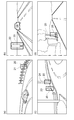
まず、撮像装置2から入力された物体の撮像画像に対して、対象物候補探索部5は対象物候補探索を行う(図3のS1)。対象物候補探索は、撮像画像の全体あるいは一部をサブウィンドウのような撮像画像より小さい領域で切り出すような処理である。例えば、この対象物候補探索は、図4(a)〜(d)に示すように、対象物候補となり得るカードレール21、看板22、歩行者23、電柱24、樹木25等を囲う処理枠20で撮像画像を切り出すことにより行うことができる。あるいは、この対象物候補探索は、撮像画像の全体あるいは一部に対して、特徴点抽出処理(例えばコーナー検出)を行い、抽出された特徴点の近傍の画像を切り出すことによっても行うことができる。図4の例では、図4(c)において歩行者23を処理枠20内に捉えている以外は、ガードレール21等の静止物体を誤って対象物候補として認識している。
First, the target candidate search unit 5 performs a target candidate search on the captured image of the object input from the imaging device 2 (S1 in FIG. 3). The object candidate search is a process in which the entire captured image or a part of the captured image is cut out in an area smaller than the captured image such as a sub window. For example, as shown in FIGS. 4A to 4D, the object candidate search is performed by a
図3に戻り、対象物候補探索により切り出された画像に対して、対象物識別部6は対象物識別を行い、当該画像にかかる物体が対象物であるか否かを判定する(図3のS2)。対象物識別部6は、対象物識別を行った後、当該画像と識別結果とを静止物判定部7に送る。
Returning to FIG. 3, the object identifying unit 6 performs object identification on the image cut out by the object candidate search, and determines whether or not the object related to the image is the object (FIG. 3). S2). The object identifying unit 6 sends the image and the identification result to the stationary
対象物位置検出装置3は、対象物として識別された物体の絶対位置を測定する(図3のS3)。対象物位置検出装置3は、検出した物体の絶対位置を地図データ参照部8に送る。静止物判定部7は、対象物として識別された物体が静止しているか否かの判定を行う(図3のS4)。なお、図3の例では、S1,S2,S3,S4の順に処理を行っているが、S1,S2およびS4の各々の処理の前後に、S3の対象物位置測定の処理を行うことができ、その順序は問わない。
The object
地図データ参照部8は、静止物判定部7により静止していると判定された物体について、対象物位置検出装置3により測定された当該物体の絶対位置(緯度、経度)をクエリーにして、地図データベース9に当該絶対位置に対応する画像データが存在するか否かの検索を行う(図3のS5)。地図データベース9は、当該絶対位置に対応する静止物体あるいは静止物体候補の画像データを返す。
The map
画像一致度比較部10は、絶対位置に対応する静止物体あるいは静止物体候補の画像データが存在する場合は、それらの撮像装置2による物体の撮像画像との一致度を判定する(図3のS6)。もし、図3のS5の処理で対応する画像データが存在しない場合、あるいは図3のS6の処理で不一致と判定された場合は、一致回数カウント部11は一致回数を0に計数し、地図データ登録部12は、当該物体の撮像画像を静止物体候補の画像として、当該絶対位置、一致回数0と対応付けて地図データベース9に登録する(図3のS7)。
When there is still object or still object candidate image data corresponding to the absolute position, the image coincidence
もし、図3のS6の処理で一致と判定された場合は、物体の撮像画像が静止物体の画像と一致するときは(図3のS8)、画像一致度比較部10は、当該物体は静止物体である旨の指令を対象物識別部6に送信し、対象物識別部6は、以後、当該物体を対象物と認識しない(図3のS11)。図3のS6の処理で一致と判定された場合であって、物体の撮像画像が静止物体候補の画像と一致するときは、その画像データの一致回数と設定した閾値との比較を行う(図3のS9)。この場合、図3のS9の処理で一致回数が閾値未満であった場合は、一致回数カウント部11は一致回数に1を加算する(図3のS10)。一方、図3のS8の処理で一致回数が閾値以上であった場合は、その物体は静止物体であると判定し、地図データ登録部12は、当該画像データを静止物体の画像として地図データベース9に登録する。また、地図データ登録部12は、当該物体は静止物体である旨の指令を対象物識別部6に送信し、対象物識別部6は、当該物体の対象物としての認識を中断し、以後、当該物体を対象物と認識しない(図3のS11)。
If it is determined in step S6 in FIG. 3 that the images match the captured image of the object (S8 in FIG. 3), the image matching
本実施形態では、撮像装置2は物体を撮像し、対象物識別部6は物体が対象物か否かを識別し、静止物判定部7は対象物識別部6により対象物と識別された物体が静止しているか否かを判定するため、検証する対象を静止物と誤認しやすい物体に絞ることができる。
In the present embodiment, the imaging device 2 images an object, the object identification unit 6 identifies whether or not the object is a target, and the stationary
また、対象物位置検出装置3は物体の位置を測定し、地図データベース9は位置と静止物体の画像とを対応付けて記憶し、地図データ参照部8は対象物位置検出装置3により測定された物体の位置に対応する静止物体の画像を地図データベース9から抽出するため、地図データベース9から検証の基礎となる静止物体の画像を抽出することができる。
The object
そして、画像一致度比較部10は、物体の撮像画像と物体の位置に対応する静止物体の画像との一致度を比較し、対象物識別部6は、一致度が閾値以上のときは、対象物と識別した物体を以後対象物と識別しないため、撮像した物体の画像と地図データベース9に登録された静止物体の画像とを直接比較して、一致度が高い物は静止物体として対象物から除くことができ、静止物体との誤検出を一層防止しつつ対象物を認識することができる。
The image coincidence
また、本実施形態では、静止物判定部7により静止していると判定され、実際に静止物である可能性がある物体の撮像画像を地図データベース9に静止物体候補の画像として登録するため、地図データベース9の内容を更新することができる。また、静止物体候補の画像に基づいて、物体が実際に静止物体か否かを判定し、一致度が閾値以上のときは一致回数に1を加えた数値を地図データベース9に登録するため、静止物体候補が実際に静止物体である可能性の高さをも更新することができる。
In the present embodiment, the stationary
さらに、地図データ登録部12は、静止物体候補の一致回数が閾値以上のときは、地図データベース9に静止物体候補の画像を静止物体の画像として登録するため、静止物体候補の内で実際に静止物体である信憑性が高い物体を静止物体として登録し直すことができる。
Further, the map
本実施形態においては、地図データベース9に記憶される静止物体は高い頻度で検出対象物として誤検出されるものに限定しているため、コンパクトなデータベースを実現できる。また、地図データベース9の利用方法は、物体の撮像画像と静止物体の画像とを直接比較する方法であるため、物体の撮像画像は単眼カメラで取得したものでも適用でき、必ずしも複数のカメラによるステレオ処理等を必要としない。 In the present embodiment, since the stationary objects stored in the map database 9 are limited to those that are erroneously detected as detection objects at a high frequency, a compact database can be realized. In addition, since the method of using the map database 9 is a method in which a captured image of an object is directly compared with an image of a stationary object, the captured image of the object can be applied even if it is acquired with a monocular camera, and is not necessarily limited to stereo images from multiple cameras. No processing is required.
尚、本発明の認識装置、地図データ作成装置および認識方法は、上記した実施の形態に限定されるものではなく、本発明の要旨を逸脱しない範囲内において種々変更を加え得ることは勿論である。
Note that the recognition device , map data creation device, and recognition method of the present invention are not limited to the above-described embodiments, and various modifications can be made without departing from the scope of the present invention. .
1…認識装置、2…撮像装置、3…対象物位置検出装置、4…データ処理装置、5…対象物候補探索部、6…対象物識別部、7…静止物判定部、8…地図データ参照部、9…地図データベース、10…画像一致度比較部、11…一致回数カウント部、12…地図データ登録部、20…処理枠、21…ガードレール、22…看板、23…歩行者、24…電柱、25…樹木。
DESCRIPTION OF
Claims (8)
前記撮像手段により取得した前記物体の撮像画像によって、前記物体が対象物か否かを識別する対象物識別手段と、
前記物体の位置を測定する対象物位置検出手段と、
前記撮像手段の位置を測定する自己位置測定手段と、
静止物体の位置と、前記撮像手段の位置と、前記静止物体及び前記撮像手段の位置における前記静止物体の画像とを対応付けて記憶した地図データベースと、
前記対象物位置検出手段により測定された前記物体の位置と、前記自己位置測定手段により測定された前記撮像手段の位置とに対応する前記静止物体の画像を、前記地図データベースから抽出する地図データ参照手段と、
前記対象物識別手段により対象物と識別された前記物体の前記撮像手段による撮像画像と、前記地図データ参照手段により抽出された前記物体の位置と前記撮像手段の位置とに対応する前記静止物体の画像との一致度を比較する画像一致度比較手段と、を備え、
前記対象物識別手段は、前記一致度が閾値以上のときは、前記対象物と識別した物体を以後対象物と識別しない、認識装置。 Imaging means for imaging an object;
Object identifying means for identifying whether or not the object is a target object based on a captured image of the object acquired by the imaging means;
Object position detecting means for measuring the position of the object;
Self-position measuring means for measuring the position of the imaging means;
A map database that stores the position of a stationary object, the position of the imaging unit, and the stationary object and the image of the stationary object at the position of the imaging unit in association with each other;
Reference to map data for extracting an image of the stationary object corresponding to the position of the object measured by the object position detecting means and the position of the imaging means measured by the self-position measuring means from the map database Means,
The stationary object corresponding to the captured image of the object identified as the object by the object identifying means, the position of the object extracted by the map data reference means, and the position of the imaging means. Image matching degree comparing means for comparing the degree of coincidence with the image,
The object identification means is a recognition apparatus in which, when the degree of coincidence is equal to or greater than a threshold value, the object identified as the object is not identified from the object thereafter.
静止物体の位置と、前記撮像手段の位置と、前記静止物体及び前記撮像手段の位置における前記静止物体の画像とを対応付けて記憶した地図データベースと、
前記物体が静止しているか否かを判定するとともに前記物体が対象物か否かを識別する静止物判定手段と、
前記物体の位置を測定する対象物位置検出手段と、
前記撮像手段の位置を測定する自己位置測定手段と、
前記静止物判定手段により静止していると判定され、かつ前記静止物判定手段により対象物と識別された前記物体の前記撮像手段による撮像画像を、前記対象物位置検出手段が測定した前記物体の位置と、前記自己位置測定手段が測定した前記撮像手段の位置と対応付けて、前記地図データベースに静止物体候補の画像として登録する地図データ登録手段と、を備える地図データ作成装置。 Imaging means for imaging an object;
A map database that stores the position of a stationary object, the position of the imaging unit, and the stationary object and the image of the stationary object at the position of the imaging unit in association with each other;
A stationary object determination means for determining whether or not the object is stationary and identifying whether or not the object is an object ;
Object position detecting means for measuring the position of the object;
Self-position measuring means for measuring the position of the imaging means;
The image of the object measured by the object position detection unit is the image captured by the imaging unit of the object that is determined to be stationary by the stationary object determination unit and is identified as the target by the stationary object determination unit . A map data creation device comprising map data registration means for registering a position and an image of a stationary object candidate in the map database in association with the position of the imaging means measured by the self-position measurement means.
前記対象物位置検出手段により測定された前記物体の位置と前記自己位置測定手段により測定された前記撮像手段の位置とに対応する前記静止物体候補の画像を、前記地図データベースから抽出する地図データ参照手段と、をさらに備え、
前記対象物識別手段により対象物と識別され前記静止物判定手段により静止していると判定された前記物体の前記撮像手段による撮像画像と、前記地図データ参照手段により抽出された前記物体の位置と前記撮像手段の位置とに対応する静止物体の画像との一致度を比較する画像一致度比較手段をさらに備え、
前記地図データ登録手段は、前記画像一致度比較手段が比較した前記一致度が閾値以上のときは、前記静止物体候補の一致回数として、1を加えた数値を前記地図データベースに登録する、請求項2に記載の地図データ作成装置。 Object identifying means for identifying whether or not the object is a target object based on a captured image of the object acquired by the imaging means;
Reference to map data for extracting an image of the stationary object candidate corresponding to the position of the object measured by the object position detecting means and the position of the imaging means measured by the self-position measuring means from the map database And further comprising means,
The captured image of the object that has been identified as the object by the object identifying means and determined to be stationary by the stationary object determining means, and the position of the object extracted by the map data reference means Image matching degree comparison means for comparing the degree of coincidence with the image of the stationary object corresponding to the position of the imaging means,
The map data registration unit registers a numerical value obtained by adding 1 to the map database as the number of matching times of the stationary object candidate when the matching level compared by the image matching level comparing unit is equal to or greater than a threshold value. 2. The map data creation device according to 2.
前記撮像ステップで取得された前記物体の撮像画像によって、前記物体が対象物か否かを識別する対象物識別ステップと、
前記物体が静止しているか否かを判定する静止物判定ステップと、
前記物体の位置を測定する対象物位置検出ステップと、
前記撮像手段の位置を測定する自己位置測定ステップと、
前記対象物位置検出ステップで測定した前記物体の位置と、前記自己位置測定ステップにより測定した前記撮像手段の位置とに対応する静止物体の画像を、前記静止物体の位置と、前記撮像手段の位置と、前記静止物体及び前記撮像手段の位置における前記静止物体の画像とが対応付けて記憶された地図データベースから抽出する地図データ参照ステップと、
前記対象物識別ステップで対象物と識別され前記静止物判定ステップで静止していると判定された前記物体の撮像画像と、前記地図データ参照ステップで抽出した前記物体の位置と前記撮像手段の位置とに対応する静止物体の画像との一致度を比較する画像一致度比較ステップと、を含み、
前記対象物識別ステップでは、前記一致度が閾値以上のときは、前記対象物と識別した物体を以後対象物と識別しない認識方法。 An imaging step of imaging an object by an imaging means;
An object identification step for identifying whether or not the object is a target object based on a captured image of the object acquired in the imaging step;
A stationary object determination step for determining whether or not the object is stationary;
An object position detecting step for measuring the position of the object;
A self-position measuring step for measuring the position of the imaging means;
An image of a stationary object corresponding to the position of the object measured in the object position detection step and the position of the imaging means measured in the self-position measurement step, the position of the stationary object, and the position of the imaging means A map data reference step for extracting from the map database stored in association with the stationary object and the image of the stationary object at the position of the imaging means;
The captured image of the object that has been identified as the object in the object identification step and determined to be stationary in the stationary object determination step, the position of the object extracted in the map data reference step, and the position of the imaging means And an image matching degree comparison step for comparing the degree of coincidence with an image of a stationary object corresponding to
In the object identification step, when the degree of coincidence is equal to or greater than a threshold value, a recognition method in which an object identified as the object is not identified from the object thereafter.
前記画像一致度比較ステップは、前記対象物識別ステップで対象物と識別された前記物体の撮像画像と、前記地図データ参照ステップで抽出された前記物体の位置に対応する静止物体候補の画像との一致度を比較し、
前記地図データ登録ステップは、前記一致度が閾値以上のときは、前記静止物体候補の一致回数として、1を加えた数値を前記地図データベースに登録する、請求項6に記載の認識方法。 In the map data reference step, an image of the stationary object candidate corresponding to the position of the object measured in the object position detection step and the position of the imaging unit measured in the self-position measurement step is used as the map. Extract from the database,
The image matching degree comparison step includes: a captured image of the object identified as a target in the target identification step; and a still object candidate image corresponding to the position of the object extracted in the map data reference step. Compare the match,
The recognition method according to claim 6, wherein when the degree of coincidence is equal to or greater than a threshold, the map data registration step registers a numerical value obtained by adding 1 as the number of coincidence of the stationary object candidates in the map database.
Priority Applications (1)
| Application Number | Priority Date | Filing Date | Title |
|---|---|---|---|
| JP2006137907A JP4984640B2 (en) | 2006-05-17 | 2006-05-17 | Recognition device, map data creation device, and recognition method |
Applications Claiming Priority (1)
| Application Number | Priority Date | Filing Date | Title |
|---|---|---|---|
| JP2006137907A JP4984640B2 (en) | 2006-05-17 | 2006-05-17 | Recognition device, map data creation device, and recognition method |
Publications (3)
| Publication Number | Publication Date |
|---|---|
| JP2007310572A JP2007310572A (en) | 2007-11-29 |
| JP2007310572A5 JP2007310572A5 (en) | 2009-06-25 |
| JP4984640B2 true JP4984640B2 (en) | 2012-07-25 |
Family
ID=38843381
Family Applications (1)
| Application Number | Title | Priority Date | Filing Date |
|---|---|---|---|
| JP2006137907A Expired - Fee Related JP4984640B2 (en) | 2006-05-17 | 2006-05-17 | Recognition device, map data creation device, and recognition method |
Country Status (1)
| Country | Link |
|---|---|
| JP (1) | JP4984640B2 (en) |
Families Citing this family (9)
| Publication number | Priority date | Publication date | Assignee | Title |
|---|---|---|---|---|
| JP2010072947A (en) * | 2008-09-18 | 2010-04-02 | Toyota Motor Corp | Obstacle detection device |
| KR101573289B1 (en) | 2008-11-27 | 2015-12-01 | 삼성전자주식회사 | Apparatus and method for recongnizing position using camera |
| JP5403152B2 (en) * | 2010-05-10 | 2014-01-29 | トヨタ自動車株式会社 | Risk calculation device |
| JP5776678B2 (en) | 2012-12-21 | 2015-09-09 | トヨタ自動車株式会社 | Vehicle equipped with power control unit |
| US10359841B2 (en) | 2013-01-13 | 2019-07-23 | Qualcomm Incorporated | Apparatus and method for controlling an augmented reality device |
| JP6292175B2 (en) * | 2015-06-08 | 2018-03-14 | トヨタ自動車株式会社 | Collision detection device |
| CN107976319B (en) * | 2017-10-13 | 2020-06-16 | 上海眼控科技股份有限公司 | Intelligent detection system and method for car additionally provided with pedal |
| JP7147448B2 (en) * | 2018-10-10 | 2022-10-05 | トヨタ自動車株式会社 | map information system |
| US11436812B2 (en) * | 2020-05-29 | 2022-09-06 | Open Space Labs, Inc. | Machine learning based object identification using scaled diagram and three-dimensional model |
Family Cites Families (4)
| Publication number | Priority date | Publication date | Assignee | Title |
|---|---|---|---|---|
| JPH10304339A (en) * | 1996-10-03 | 1998-11-13 | Masanobu Kujirada | Vehicle video providing system and virtual vehicle traveling system |
| JP2002286416A (en) * | 2001-03-23 | 2002-10-03 | Honda Motor Co Ltd | Obstacle-recognizing apparatus |
| JP3781370B2 (en) * | 2002-11-19 | 2006-05-31 | 本田技研工業株式会社 | Mobile device |
| JP4313712B2 (en) * | 2004-03-30 | 2009-08-12 | 本田技研工業株式会社 | Travel safety device |
-
2006
- 2006-05-17 JP JP2006137907A patent/JP4984640B2/en not_active Expired - Fee Related
Also Published As
| Publication number | Publication date |
|---|---|
| JP2007310572A (en) | 2007-11-29 |
Similar Documents
| Publication | Publication Date | Title |
|---|---|---|
| JP4984640B2 (en) | Recognition device, map data creation device, and recognition method | |
| CN107563419B (en) | Train positioning method combining image matching and two-dimensional code | |
| CN108151750B (en) | Positioning method and device | |
| US9123242B2 (en) | Pavement marker recognition device, pavement marker recognition method and pavement marker recognition program | |
| JP4970195B2 (en) | Person tracking system, person tracking apparatus, and person tracking program | |
| US11348371B2 (en) | Person detection system | |
| US9047518B2 (en) | Method for the detection and tracking of lane markings | |
| WO2009150783A1 (en) | Pattern recognition device, pattern recognition method, image-processing device and image-processing method | |
| JP2011059810A (en) | Image recognition system | |
| US20170254651A1 (en) | Localization and mapping method and system | |
| JP5931662B2 (en) | Road condition monitoring apparatus and road condition monitoring method | |
| WO2014181386A1 (en) | Vehicle assessment device | |
| CN111383246B (en) | Scroll detection method, device and equipment | |
| US11941716B2 (en) | Systems and methods for electronic signature tracking | |
| CN108573244B (en) | Vehicle detection method, device and system | |
| JP2007310572A5 (en) | ||
| KR20160040036A (en) | A car number plate recognition method and recognition device that uses a number of IP cameras | |
| CN105869406A (en) | Vehicle identification and detection system, vehicle information collection method, vehicle information detection and recording method and vehicle information inquiry method | |
| CN112598743B (en) | Pose estimation method and related device for monocular vision image | |
| KR20130089068A (en) | Apparatus and method correcting location of car using camera | |
| JP5327241B2 (en) | Object identification device | |
| Priambada et al. | Levensthein distance as a post-process to improve the performance of ocr in written road signs | |
| KR101560810B1 (en) | Space controled method and apparatus for using template image | |
| TWI515667B (en) | Vehicle recognition and detection system, vehicle information collection method, vehicle information detection method and vehicle information inquiry method | |
| KR101804471B1 (en) | Method And Apparatus for Analyzing Video |
Legal Events
| Date | Code | Title | Description |
|---|---|---|---|
| A521 | Written amendment |
Free format text: JAPANESE INTERMEDIATE CODE: A523 Effective date: 20090513 |
|
| A621 | Written request for application examination |
Free format text: JAPANESE INTERMEDIATE CODE: A621 Effective date: 20090513 |
|
| A977 | Report on retrieval |
Free format text: JAPANESE INTERMEDIATE CODE: A971007 Effective date: 20110428 |
|
| A131 | Notification of reasons for refusal |
Free format text: JAPANESE INTERMEDIATE CODE: A131 Effective date: 20110510 |
|
| A521 | Written amendment |
Free format text: JAPANESE INTERMEDIATE CODE: A523 Effective date: 20110706 |
|
| A131 | Notification of reasons for refusal |
Free format text: JAPANESE INTERMEDIATE CODE: A131 Effective date: 20111108 |
|
| A521 | Written amendment |
Free format text: JAPANESE INTERMEDIATE CODE: A523 Effective date: 20120110 |
|
| TRDD | Decision of grant or rejection written | ||
| A01 | Written decision to grant a patent or to grant a registration (utility model) |
Free format text: JAPANESE INTERMEDIATE CODE: A01 Effective date: 20120403 |
|
| A01 | Written decision to grant a patent or to grant a registration (utility model) |
Free format text: JAPANESE INTERMEDIATE CODE: A01 |
|
| A61 | First payment of annual fees (during grant procedure) |
Free format text: JAPANESE INTERMEDIATE CODE: A61 Effective date: 20120416 |
|
| R151 | Written notification of patent or utility model registration |
Ref document number: 4984640 Country of ref document: JP Free format text: JAPANESE INTERMEDIATE CODE: R151 |
|
| FPAY | Renewal fee payment (event date is renewal date of database) |
Free format text: PAYMENT UNTIL: 20150511 Year of fee payment: 3 |
|
| LAPS | Cancellation because of no payment of annual fees |