JP4463675B2 - Car navigation system - Google Patents
Car navigation system Download PDFInfo
- Publication number
- JP4463675B2 JP4463675B2 JP2004371691A JP2004371691A JP4463675B2 JP 4463675 B2 JP4463675 B2 JP 4463675B2 JP 2004371691 A JP2004371691 A JP 2004371691A JP 2004371691 A JP2004371691 A JP 2004371691A JP 4463675 B2 JP4463675 B2 JP 4463675B2
- Authority
- JP
- Japan
- Prior art keywords
- vehicle
- displayed
- screen
- display
- route
- Prior art date
- Legal status (The legal status is an assumption and is not a legal conclusion. Google has not performed a legal analysis and makes no representation as to the accuracy of the status listed.)
- Expired - Fee Related
Links
Images


Landscapes
- Navigation (AREA)
- Traffic Control Systems (AREA)
- Instructional Devices (AREA)
Description
本発明は、誘導経路に従って車両を目的地まで案内する車載用ナビゲーション装置に関し、特に、有料道路に付帯する施設(例えば、インターチェンジやパーキングエリア)の情報を地図上に表示する機能を備えた車載用ナビゲーション装置に関する。なお、以下の記述において特に定義しない限り、単に「車両」とは、自車を指すものとする。 The present invention relates to an in-vehicle navigation device that guides a vehicle to a destination according to a guidance route, and more particularly, an in-vehicle navigation device having a function of displaying information on facilities (for example, interchanges and parking areas) attached to toll roads on a map. The present invention relates to a navigation device. Unless otherwise defined in the following description, the term “vehicle” simply refers to the own vehicle.
従来の典型的な車載用ナビゲーション装置は、ナビゲーションに係る一切の処理を制御するCPU等の制御装置、地図データを予め記憶させたDVD(Digital Versatile Disk)−ROMやICメモリカード等の記憶装置、表示装置、GPS(Global Positioning System)受信機、ジャイロや車速センサ等の車両の現在位置及び現在方位を検出する検出装置等を有している。そして、制御装置により、車両の現在位置を含む地図データを記憶装置から読み出し、該地図データに基づいて車両位置の周囲の地図画像を表示装置の画面に表示すると共に、自車の現在位置を指示する車両位置マークを地図画像に重ね合わせて表示し、車両の移動に応じて地図画像をスクロール表示したり、地図画像を画面に固定し車両位置マークを移動させたりして、車両が現在どこを走行しているのかを一目で判るようにしている。 Conventional typical vehicle-mounted navigation devices include a control device such as a CPU that controls all processing related to navigation, a storage device such as a DVD (Digital Versatile Disk) -ROM or an IC memory card that stores map data in advance, It has a display device, a GPS (Global Positioning System) receiver, a detection device that detects the current position and current direction of the vehicle, such as a gyro and a vehicle speed sensor. Then, the control device reads out map data including the current position of the vehicle from the storage device, displays a map image around the vehicle position on the display device screen based on the map data, and indicates the current position of the host vehicle. The vehicle position mark to be displayed is superimposed on the map image, the map image is scrolled according to the movement of the vehicle, the map image is fixed on the screen and the vehicle position mark is moved, and where the vehicle is currently located. You can see at a glance whether you are driving.
また、通常、車載用ナビゲーション装置には、ユーザ(例えば運転者)が所望の目的地を設定すると、その目的地に向けて道路を間違うことなく容易に走行できるようにした経路誘導機能が搭載されている。この経路誘導機能によれば、地図データを用いて出発地から目的地までを結ぶ最適な経路を横型探索法又はダイクストラ法等のシミュレーション計算を行って自動探索し、その探索した経路を誘導経路として記憶しておき、走行中、地図画像上に誘導経路を他の道路とは色を変えて太く描画して画面表示したり、車両が誘導経路上の進路を変更すべき交差点に一定距離内に近づいたときに、地図画像上の進路を変更すべき交差点に進路を示す矢印を描画して画面表示したりすることで、ユーザを目的地まで案内する。 In general, in-vehicle navigation devices are equipped with a route guidance function that allows a user (for example, a driver) to set a desired destination and easily travel on the road without making a mistake. ing. According to this route guidance function, the optimum route connecting from the starting point to the destination is automatically searched by performing simulation calculation such as horizontal search method or Dijkstra method using the map data, and the searched route is used as the guide route. Remember, while driving, draw the guidance route on the map image with a different color from other roads and display it on the screen, or within a certain distance to the intersection where the vehicle should change the course on the guidance route When approaching, the user is guided to the destination by drawing an arrow indicating the course at the intersection where the course should be changed on the map image and displaying it on the screen.
経路探索時には、予めユーザが目的地を設定し、必要に応じて目的地に至る途中の経由地を設定する。また、必要であれば、各種の条件(有料道路優先で行くのか又は一般道路優先で行くのか等)も併せて設定する。ナビゲーション装置では、これらの設定されたデータに基づいて、目的地までの複数の経路の探索を行い、探索された経路を例えば色分けして表示し、その中からユーザが選択した1つの経路に従って経路案内を行う。 When searching for a route, the user sets a destination in advance, and sets a waypoint on the way to the destination as necessary. If necessary, various conditions (whether toll road priority or general road priority) are also set. In the navigation device, a plurality of routes to the destination are searched based on these set data, and the searched routes are displayed in different colors, for example, according to one route selected by the user. Give guidance.
このようなナビゲーション装置において、表示画面上に地図を表示するとともに、地図が表示されている範囲内にある施設の名称を表示することが行われている。例えば、特許文献1には、施設の名称を誘導経路と重複しないように表示画面上に表示し、誘導経路近傍の情報であるか否かを素早く把握できるようにする技術が開示されている。 In such a navigation device, a map is displayed on a display screen, and names of facilities in a range where the map is displayed are displayed. For example, Patent Document 1 discloses a technique for displaying the name of a facility on a display screen so as not to overlap with a guidance route so that it is possible to quickly grasp whether the information is in the vicinity of the guidance route.
また、誘導経路に含まれる有料道路を表示する際には、表示画面上に有料道路に付帯する施設の情報としてIC(インターチェンジ)、JCT(ジャンクション)、SA(サービスエリア)、PA(パーキングエリア)等の各種施設の名称が誘導経路の左側又は右側に表示され、有料道路の出口等の情報を取得することができるようになっている。
上述したように従来の車載用ナビゲーション装置では、経路誘導機能により目的地に向けた経路案内を行う際に、有料道路に付帯する各種施設の名称も併せて当該道路の近傍に表示するようにしている。そして、このような状況で、自車が現在走行している誘導経路上で前方の施設等を確認したい場合に、ユーザによるリモコン操作等によって表示画面をスクロールし、所望の地域を表示画面に表示することがある。しかし、この場合に以下の不都合が生じる。 As described above, in the conventional in-vehicle navigation device, when performing route guidance toward the destination by the route guidance function, the names of various facilities attached to the toll road are also displayed in the vicinity of the road. Yes. In such a situation, when the user wants to check the facilities ahead on the guidance route on which the vehicle is currently traveling, the display screen is scrolled by a remote control operation by the user and the desired area is displayed on the display screen. There are things to do. However, in this case, the following inconvenience occurs.
すなわち、表示画面のスクロールにより誘導経路上で自車位置からかなり前方の場所を表示させると、誘導経路付近の施設の情報はもちろん表示されるが、自車位置を示す車両位置マークについては、スクロール量にもよるが、画面内から外れてしまう場合がある。車両位置マークが画面内の誘導経路上に表示されていればその車両位置マークが示す方向により自車の進行方向を把握できるので、特に不都合は無い。 In other words, if a location that is considerably ahead of the vehicle position on the guidance route is displayed by scrolling the display screen, information on the facility near the guidance route is displayed, but the vehicle position mark indicating the vehicle location is scrolled. Depending on the amount, it may fall out of the screen. If the vehicle position mark is displayed on the guidance route in the screen, the traveling direction of the host vehicle can be grasped from the direction indicated by the vehicle position mark, so there is no particular inconvenience.
しかし、車両位置マークが画面内の誘導経路上に表示されない場合、自車の進行方向を容易に判断できない場合が起こりうる。特に、地図の「北」側が表示画面の上側になるように表示する、いわゆる「ノースアップ(North-up)方式」の表示態様を採用すると、例えば、誘導経路上を南向き(表示画面の下方向)に走行している場合、上記のように車両位置マークが画面上に表示されていないと進行方向を把握しづらいといった問題が生じる。また、南向き(表示画面の下方向)に限らず、これ以外の方向に向けて自車が走行している場合にも、車両位置マークが表示されていないと自車の進行方向を把握しづらい。 However, when the vehicle position mark is not displayed on the guidance route in the screen, the traveling direction of the host vehicle may not be easily determined. In particular, when the so-called “North-up” display mode is adopted, in which the “North” side of the map is displayed on the upper side of the display screen, for example, the direction on the guidance route is directed southward (below the display screen). When traveling in a direction), there is a problem that it is difficult to grasp the traveling direction unless the vehicle position mark is displayed on the screen as described above. In addition, when the vehicle is traveling in a direction other than the south direction (downward on the display screen), the traveling direction of the vehicle is grasped if the vehicle position mark is not displayed. It ’s hard.
かかる問題は、ノースアップ方式の表示態様に限らず、自車の進行方向が表示画面の上側に向くように表示する、いわゆる「ノーズアップ(Nose-up)方式」の表示態様の場合にも同様に起こり得る。 This problem is not limited to the north-up display mode, but also in the case of the so-called “nose-up” display mode in which the traveling direction of the vehicle is directed to the upper side of the display screen. Can happen.
本発明は、かかる従来技術の課題に鑑みなされたものであり、車両位置マークの表示の有無にかかわらず誘導経路上での車両の進行方向を容易に判断できるようにし、ひいてはユーザメリットを高めることができる車載用ナビゲーション装置を提供することである。 The present invention has been made in view of the problems of the prior art, and makes it possible to easily determine the traveling direction of the vehicle on the guidance route regardless of whether or not the vehicle position mark is displayed, thereby improving the user's merit. It is providing the vehicle-mounted navigation apparatus which can do.
上述した従来技術の課題を解決するため、本発明の基本形態によれば、画面上で案内情報を提供する表示手段と、地図データ及び各種施設に関する情報を格納したメモリ手段と、前記表示手段及びメモリ手段に動作可能に接続された制御手段とを有し、前記制御手段は、前記表示手段の画面上で目的地までの誘導経路の案内を行っている状態で、当該誘導経路に有料道路が含まれているときに、前記メモリ手段から当該誘導経路に含まれる有料道路に付帯する施設の情報を取得し、前記誘導経路が案内されている画面上に自車両の位置が含まれているか否かにかかわらず、当該取得した施設の情報を、前記誘導経路上で当該施設の存在位置の近傍であって車両の進行方向の左側に位置するように前記表示手段の画面上に表示させることを特徴とする車載用ナビゲーション装置が提供される。 In order to solve the above-described problems of the prior art, according to the basic form of the present invention, display means for providing guidance information on a screen, memory means for storing information relating to map data and various facilities, the display means, Control means operably connected to the memory means, and the control means provides guidance on the guidance route to the destination on the screen of the display means, and there is a toll road on the guidance route. When it is included, information on the facility incidental to the toll road included in the guidance route is acquired from the memory means, and whether or not the position of the host vehicle is included on the screen on which the guidance route is guided Regardless of whether the acquired facility information is displayed on the screen of the display means so as to be positioned on the left side of the traveling direction of the vehicle in the vicinity of the location of the facility on the guidance route. Characteristic In-vehicle navigation device that is provided.
本発明においては、車載用ナビゲーション装置において、誘導経路に有料道路が含まれているときに、その有料道路に付帯する施設の情報を車両の進行方向に向かって当該道路の左側だけに表示するようにしている。これにより、表示画面をスクロールしたことにより車両位置マークが表示されなくなっても、車両の進行方向を容易に判断することができる。特に、ノースアップ方式の表示態様を採用した場合に有効であり、ユーザメリットを高めることができる。 In the present invention, in the in-vehicle navigation device, when a toll road is included in the guidance route, information on a facility incidental to the toll road is displayed only on the left side of the road toward the traveling direction of the vehicle. I have to. Thereby, even if the vehicle position mark is not displayed due to the scrolling of the display screen, the traveling direction of the vehicle can be easily determined. In particular, this is effective when the north-up display mode is adopted, and the user merit can be enhanced.
また、上記の形態に係る車載用ナビゲーション装置において、前記制御手段は、前記誘導経路に含まれる有料道路に付帯する施設の情報を、当該誘導経路以外の有料道路に付帯する施設の情報より強調した表示態様で前記表示手段の画面上に表示させるようにしてもよい。 In the in-vehicle navigation device according to the above aspect, the control unit emphasizes information on facilities attached to the toll road included in the guidance route from information on facilities attached to the toll road other than the guidance route. You may make it display on the screen of the said display means with a display mode.
本発明においては、誘導経路の有料道路に付帯する施設の情報の表示を誘導経路以外の有料道路に付帯する施設の情報の表示と比較して相対的に強調して表示するようにしている。これにより、誘導経路がどこかをよりわかり易くすることができる。また、経路上のIC等の情報を把握しやすくできる。 In the present invention, the display of the information on the facility incidental to the toll road on the guidance route is displayed with a relatively emphasized comparison with the display of the information on the facility incidental to the toll road other than the guidance route. This makes it easier to understand where the guidance route is. In addition, it is possible to easily grasp information such as ICs on the route.
以下、本発明の実施形態について、添付の図面を参照して説明する。
(車載用ナビゲーション装置の構成)
図1は本発明の一実施形態に係る車載用ナビゲーション装置の構成を示すブロック図である。
Hereinafter, embodiments of the present invention will be described with reference to the accompanying drawings.
(Configuration of in-vehicle navigation system)
FIG. 1 is a block diagram showing a configuration of an in-vehicle navigation device according to an embodiment of the present invention.
図中、1は地図データその他の案内データが記憶されている記憶媒体である。本実施形態では、このようなデータを記憶する記憶媒体としてDVD(DVD−ROM)を使用しているが、ハードディスク又はその他の記憶媒体を使用してもよい。ここに格納されている地図は、1/12500、1/25000、1/50000、1/100000等の各縮尺レベルに応じて適当な大きさの経度幅及び緯度幅に区切られており、この地図に含まれる道路、建築物、施設その他の各種物件は、経度及び緯度で表現された点(ノード)の座標集合として記憶されている。地図データは、(1)道路リスト、ノードテーブル、交差点構成ノードリスト等からなる道路レイヤ、(2)地図画像上に道路、建築物、公園、河川等を表示するための背景レイヤ、(3)市町村名などの行政区画名、道路名、交差点名、有料道路に付帯する施設の名称などを指示する文字や地図記号等を表示するための文字・記号レイヤなどから構成されている。 In the figure, reference numeral 1 denotes a storage medium in which map data and other guidance data are stored. In the present embodiment, a DVD (DVD-ROM) is used as a storage medium for storing such data, but a hard disk or other storage medium may be used. The map stored here is divided into longitude and latitude widths of appropriate sizes according to each scale level such as 1/1500, 1/25000, 1 / 50,000, 1/10000, etc. Roads, buildings, facilities, and other various properties included in are stored as a coordinate set of points (nodes) expressed in longitude and latitude. Map data includes (1) a road layer composed of a road list, a node table, an intersection configuration node list, etc., (2) a background layer for displaying roads, buildings, parks, rivers, etc. on a map image, (3) It consists of a character / symbol layer for displaying a letter indicating a name of an administrative division such as a municipality name, a road name, an intersection name, a name of a facility attached to a toll road, a map symbol, or the like.
また、2はナビゲーション装置本体10を操作するための操作ボタン等が設けられた操作部である。本実施形態では、操作部2にリモコン送信機及びリモコン受信機が含まれており、ユーザは手元のリモコン送信機でナビゲーション装置本体10を操作することもできる。
An operation unit 2 is provided with operation buttons and the like for operating the
また、5はGPS衛星から送られてくるGPS信号を受信して車両の現在位置の経度及び緯度を検出するGPS受信機、6は自立航法センサを示す。この自立航法センサ6は、車両回転角度を検出するジャイロ等の角度センサ6aと、一定の走行距離毎にパルスを発生する走行距離センサ6bとにより構成されている。
Reference numeral 5 denotes a GPS receiver that receives a GPS signal sent from a GPS satellite and detects the longitude and latitude of the current position of the vehicle. Reference numeral 6 denotes a self-contained navigation sensor. The self-contained navigation sensor 6 includes an angle sensor 6a such as a gyro that detects a vehicle rotation angle, and a
また、7は液晶パネル等の表示装置であり、ナビゲーション装置本体10は、この表示装置7に車両の現在位置の周囲の地図を表示したり、出発地から目的地までの誘導経路や車両マーク及びその他の案内情報を表示する。8は音声によりユーザに案内情報を提供するためのスピーカーである。
ナビゲーション装置本体10は以下のものから構成されている。11はDVD1からの地図データの読み取りを制御するDVDコントローラである。12はDVD1から読み出した地図データを一時的に記憶するバッファメモリである。13は操作部2と接続されるインタフェース、16はGPS受信機5と接続されるインタフェース、17は自立航法センサ6と接続されるインタフェースである。
The
18はマイクロコンピュータにより構成される制御部である。制御部18は、インタフェース16、17から入力される情報を基に車両の現在位置を検出したり、DVDコントローラ11を介してDVD1から所定の地図データをバッファメモリ12に読み出したり、バッファメモリ12に読み出された地図データを用いて設定された探索条件で出発地から目的地までの誘導経路を探索するなど、種々の処理を実行する。
19はバッファメモリ12に読み出された地図データを用いて地図画像を生成する地図描画部、20は動作状況に応じた各種メニュー画面(操作画面)や車両位置マーク及びカーソル等の各種マークを生成する操作画面・マーク発生部である。
19 is a map drawing unit that generates a map image using the map data read to the
21は制御部18で探索した誘導経路を記憶する誘導経路記憶部、22は誘導経路を描画する誘導経路描画部である。誘導経路記憶部21には、制御部18によって探索された誘導経路の全ノードが出発地から目的地まで記憶される。誘導経路描画部22は、地図を表示する際に、誘導経路記憶部21から誘導経路情報(ノード列)を読み出して、誘導経路を他の道路とは異なる色及び線幅で描画する。
21 is a guide route storage unit that stores the guide route searched by the
23は画像合成部であり、地図描画部19で描画された地図画像に、操作画面・マーク発生部20で生成した各種マークや操作画面、誘導経路描画部22で描画した誘導経路などを重ね合わせて表示装置7に表示させる。
An
24は音声出力部であり、制御部18からの信号に基づいて音声信号をスピーカー8に供給する。
An
以上のように構成された車載用ナビゲーション装置において、DVD1は「メモリ手段」に、表示装置7は「表示手段」に、制御部18は「制御手段」にそれぞれ対応している。
In the in-vehicle navigation device configured as described above, the DVD 1 corresponds to “memory means”, the
本実施形態に係る車載用ナビゲーション装置は、後述するように、有料道路に付帯する施設の情報を表示するときの動作態様が異なる点を除いて、基本的には従来の車載用ナビゲーション装置と同様に以下の動作を行う。 The in-vehicle navigation device according to the present embodiment is basically the same as the conventional in-vehicle navigation device, except that the operation mode when displaying information on facilities attached to toll roads is different, as will be described later. The following operations are performed.
すなわち、制御部18は、GPS受信機5で受信したGPS信号と自立航法センサ6で検出された信号とに基づいて車両の現在位置を検出する。そして、DVD1から車両の現在位置の周囲の地図データを読み出してバッファメモリ12に格納する。地図描画部19は、バッファメモリ12に読み出された地図データに基づいて地図画像を生成し、表示装置7に車両の現在位置の周囲の地図画像を表示する。
That is, the
また、制御部18は、車両の移動に伴ってGPS受信機5及び自立航法センサ6から出力された信号に基づいて車両の現在位置を検出し、その検出結果に応じて、表示装置7に表示された地図画像に車両位置マークを重ね合わせ、車両の移動に伴って車両位置マークを移動させたり、地図画像をスクロール表示する。
The
さらに、ユーザが操作部2を操作して目的地を設定すると、制御部18は、車両の現在位置を出発点とし、出発点から目的地までを結ぶ最もコストが低い経路をDVD1の地図データを用いて探索する。そして、探索により得られた経路を誘導経路として誘導経路記憶部21に記憶し、地図画像上にその誘導経路を重ねて表示させる。また、制御部18は車両の走行に伴って適宜案内情報を出力し、車両を目的地まで誘導経路に沿って走行するように案内する。
Further, when the user operates the operation unit 2 to set the destination, the
本実施形態に係る車載用ナビゲーション装置は、その基本的な特徴として、誘導経路となる有料道路に付帯する施設の情報の名称をすべて車両の進行方向の左側に位置するように表示している。かかる表示態様とすることで、ユーザは、表示画面上の自車の進行方向を直感的に認識しやすくなる。特に、ノースアップ方式の表示態様を採用した表示画面をスクロールし、車両位置マークが表示されなくなった場合でも、自車の進行方向を容易に把握することが可能となる。 As a basic feature of the in-vehicle navigation device according to the present embodiment, the names of the facilities information attached to the toll road as the guidance route are all displayed on the left side in the traveling direction of the vehicle. By setting it as such a display mode, it becomes easy for a user to recognize the advancing direction of the own vehicle on a display screen intuitively. In particular, even if the display screen adopting the north-up display mode is scrolled and the vehicle position mark is no longer displayed, the traveling direction of the host vehicle can be easily grasped.
また、更なる特徴として、誘導経路の有料道路に付帯する施設の情報の表示を誘導経路以外の有料道路に付帯する施設の情報の表示と比較して相対的に強調して表示するようにしている。かかる表示態様とすることにより、誘導経路上の施設の情報が強調され、誘導経路及び誘導経路上の情報が把握しやすくなる。 Further, as a further feature, the display of the information on the facility incidental to the toll road of the guidance route is displayed with a relatively emphasized comparison with the display of the information of the facility incidental to the toll road other than the guidance route. Yes. By setting it as such a display mode, the information on the facility on the guidance route is emphasized, and the guidance route and the information on the guidance route are easily grasped.
図2(a)及び(b)は、本実施形態のナビゲーション装置が行う有料道路に付帯する施設の情報の名称表示に係る画面表示例を示したものである。また、図2(c)は比較のために、従来の有料道路に付帯する施設の情報の名称表示に係る画面表示例を示したものである。 FIGS. 2A and 2B show screen display examples related to the name display of information on facilities attached to toll roads performed by the navigation device of the present embodiment. For comparison, FIG. 2C shows a screen display example related to the name display of information on facilities attached to a conventional toll road.
図2(a)は、ノースアップ方式の表示態様を採用した誘導経路の画面表示の一例である。ノースアップ方式の表示態様が採用されている場合には、表示画面30にノースアップ指示マーク31が表示されている。表示画面30に表示された地図画像30aには、車両の現在位置を示す車両位置マーク32と共に、目的地へ向かう誘導経路33が表示される。ここに、誘導経路33はユーザが識別し易いように他の道路34とは異なる表示態様(例えば、目立つ色で表示したり、線幅を太くしたりする)で表示される。
FIG. 2A is an example of a screen display of a guide route that employs a north-up display mode. When the north-up display mode is adopted, a north-up
図2(a)に示す画面表示例では、誘導経路33の車両の進行方向に向かって左側(図では誘導経路の右側)にIC35及びPA36のそれぞれの名称が表示されている。しかも、目立つようにハッチングで強調して表示されている。
In the screen display example shown in FIG. 2A, the names of the
図2(b)に示す画面表示例は、ユーザがナビゲーション装置の操作部2を操作して、図2(a)に示す地図画像30aをスクロールし、現在の走行位置よりも先の方の地図を表示している一例である。表示画面30に表示された地図画像30bに、目的地へ向かう誘導経路33が表示される。図2(a)と同様に、誘導経路33は、他の道路37、38とは異なる表示態様で表示される。ただし、車両位置マーク32は、表示画面をスクロールしたために表示されていない。
In the screen display example shown in FIG. 2 (b), the user operates the operation unit 2 of the navigation device to scroll the
また、誘導経路ではない道路38に付帯する施設43、44の名称はそれぞれ道路38の右側、左側に表示されている。これに対して誘導経路33に付帯するJCT40、SA41及びIC42のそれぞれの名称は誘導経路33の一方の側(図では、誘導経路の右側)だけに表示されている。このように、誘導経路33の一方の側だけに施設の名称を表示することにより、車両位置マーク32が表示されていなくても、車両の進行方向を把握することができる。なお、本発明においては、車両の進行方向の左側にJCT等を表示するようにしている。
Further, the names of the
図2(c)は比較のため、図2(a)に示す地図画像30aをスクロールした後の従来の表示の一例を示した図である。表示画面30に表示された地図画像30cに、目的地へ向かう誘導経路33が表示される。図2(a)と同様に、誘導経路33は他の道路37、38とは異なる表示態様で表示される。また、車両位置マーク32は表示されていない。
FIG. 2 (c) is a diagram showing an example of a conventional display after scrolling the
また、誘導経路ではない道路38に付帯する施設43、44の名称はそれぞれ道路38の右側、左側に表示されている。さらに、誘導経路33に付帯するJCT45、SA46及びIC47の名称は、それぞれ誘導経路33の左側、右側及び左側に表示される。この場合、車両位置マーク32が表示されていないために、自車の進行方向を知ることは困難である。
(有料道路に付帯する施設の情報表示)
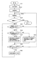
以下、本実施形態に係る車載用ナビゲーション装置が行う有料道路に付帯する施設の情報表示処理について、その処理フローの一例を示す図3を参照しながら説明する。
Further, the names of the
(Information display of facilities incidental to toll roads)
Hereinafter, the information display processing of the facility incidental to the toll road performed by the vehicle-mounted navigation device according to the present embodiment will be described with reference to FIG. 3 showing an example of the processing flow.
まず、ステップS11では、経路探索の目的地を取得する。目的地はユーザ(例えば運転者)が、操作部2からの入力操作により設定する。また、本実施形態では、有料道路を利用する場合を対象とし、探索条件として有料道路優先という条件を設定する。 First, in step S11, a route search destination is acquired. The destination is set by a user (for example, a driver) by an input operation from the operation unit 2. Further, in the present embodiment, a case where a toll road is used is targeted, and a condition of toll road priority is set as a search condition.
次のステップS12では、経路探索を行う。経路探索は、入力された目的地のデータと、GPS受信機5及び自立航法センサ6の各出力信号に基づき検出した車両の現在位置を出発地として設定された出発地のデータとに基づき、出発地から目的地までが入る範囲の地図データと経路探索用の道路データとを、DVDコントローラ11を制御してDVD1からバッファメモリ12に読み出し、さらに誘導経路記憶部21に格納されているデータを参照して、出発地から目的地まで、最短距離で結ぶ誘導経路を横型探索法などにより探索する。検索結果は誘導経路記憶部21に格納される。
In the next step S12, a route search is performed. The route search is based on the input destination data and the departure point data set based on the current position of the vehicle detected based on the output signals of the GPS receiver 5 and the autonomous navigation sensor 6. The map data in the range from the ground to the destination and the road data for route search are read from the DVD 1 to the
次のステップS13では、探索した誘導経路の案内を開始する。経路誘導はステップS12の経路探索結果に基づいた経路案内情報を表示装置7の画面を介してユーザに提供する。すなわち、画面上には地図の表示を行うとともに、誘導経路33や車両位置マーク32等を表示する。
In the next step S13, guidance of the searched guidance route is started. The route guidance provides the route guidance information based on the route search result of step S12 to the user via the screen of the
次のステップS14では、経路誘導を終了するか否かを判定する。すなわち、電源スイッチがオフになったとき又はナビゲーション装置が使用状態でないときは処理を終了し、それ以外のときはステップS15に移行する。 In the next step S14, it is determined whether or not the route guidance is terminated. That is, when the power switch is turned off or when the navigation device is not in use, the process is terminated, and in other cases, the process proceeds to step S15.
次のステップS15では、制御部18が、画面表示する地図データ及び誘導経路が記憶されている誘導経路記憶部21を参照し、画面表示する地図データ上に有料道路があるか否かを判定する。地図データ上に有料道路があると判定された場合は、ステップS16に移行し、地図データ上に有料道路がないと判定された場合は、ステップS13に戻り、通常の経路誘導を継続する。
In the next step S15, the
次のステップS16では、制御部18が、画面表示する地図データ及び誘導経路記憶部21を参照し、画面表示する有料道路が誘導経路に含まれる有料道路か否かを判定する。誘導経路に含まれる有料道路と判定された場合はステップS17に移行し、誘導経路に含まれない有料道路と判定された場合はステップS18に移行する。
In next step S16, the
次のステップS17では、誘導経路となっている有料道路に付帯する施設であるJCT35やIC36等の名称を表示する。本実施形態では、有料道路に付帯する施設の名称は、車両の進行方向左側に位置するように表示する。また、施設の名称を表示する際に、誘導経路上の施設の名称は、誘導経路以外の道路上の施設の名称表示よりも強調した表示態様で表示するようにしてもよい。なお、強調した表示態様とするために、施設の名称が目立つような色で表示したり、文字を太線で表示してもよい。
In the next step S17, names such as
一方、ステップS18では、誘導経路となっていない有料道路に付帯する施設の名称を通常の位置に表示する。すなわち、これらの施設の名称は有料道路の左側に表示したり、右側に表示したりしている。また、施設の名称を表示する際に、誘導経路に含まれる有料道路に付帯する施設の名称よりもトーンダウンした表示態様で表示するようにしてもよい。 On the other hand, in step S18, the name of the facility incidental to the toll road that is not the guidance route is displayed at the normal position. That is, the names of these facilities are displayed on the left side of the toll road or on the right side. In addition, when displaying the name of the facility, it may be displayed in a display form that is toned down from the name of the facility incidental to the toll road included in the guidance route.
次に、ステップS19では、制御部18において、操作部2からの操作による出力信号に基づいて、表示画面に対するスクロール操作があった(YES)か否(NO)かを判定する。地図画面のスクロール操作は、例えば、誘導経路の案内中に、画面に表れていない誘導経路の前方部分を確認しようとするときに行われる。
Next, in step S19, the
画面スクロール操作があったと判定された場合は、ステップS20に移行し、画面スクロールがなかったと判定された場合は、ステップS13に移行し、経路誘導を継続する。 If it is determined that there is a screen scroll operation, the process proceeds to step S20. If it is determined that there is no screen scroll, the process proceeds to step S13, and the route guidance is continued.
次のステップS20では、制御部18からの制御の下に画像合成部23を介して表示装置7の表示画面上で、スクロール操作に基づき地図を移動させて表示する。この後、ステップS15に戻って上記の処理を繰り返す。
In the next step S20, the map is moved and displayed on the display screen of the
なお、本実施形態においては、誘導経路が表示される画面表示にノースアップ方式の表示態様を採用した場合について説明したが、ノーズアップ方式の表示態様に対しても同様に適用可能であることはもちろんである。 In this embodiment, the case where the north-up display mode is adopted for the screen display on which the guidance route is displayed has been described. However, the present invention can be similarly applied to the nose-up display mode. Of course.
以上説明したように、本実施形態に係る車載用ナビゲーション装置においては、誘導経路に有料道路が含まれるとき、その有料道路に付帯するすべての施設の表示を車両の進行方向に向かって誘導経路の左側に表示する。これにより、表示画面をスクロールしたことにより車両位置マークが表示されなくなっても、車両の進行方向を容易に判断することができる。特に、ノースアップ方式の表示態様を採用した場合に有効である。 As described above, in the in-vehicle navigation device according to the present embodiment, when a toll road is included in the guidance route, the display of all facilities attached to the toll road is displayed in the direction of travel of the vehicle. Display on the left side. Thereby, even if the vehicle position mark is not displayed due to the scrolling of the display screen, the traveling direction of the vehicle can be easily determined. This is particularly effective when the north-up display mode is adopted.
また、本実施形態においては、誘導経路の有料道路に付帯する施設の情報の表示を誘導経路以外の有料道路に付帯する施設の情報の表示よりも強調して表示するようにしている。これにより、誘導経路がどこかをよりわかりやすくすることができ、誘導経路に付帯する施設の情報をより把握しやすくすることができる。 Further, in the present embodiment, the display of the information on the facility incidental to the toll road on the guidance route is displayed more emphasized than the display of the information on the facility incidental to the toll road other than the guidance route. As a result, it is possible to make it easier to understand where the guidance route is, and it is possible to make it easier to grasp the information of the facilities attached to the guidance route.
1… DVD、
2…操作部、
5…GPS受信機、
6…自立航法センサ、
7…表示装置、
8…スピーカー、
10…ナビゲーション装置本体、
18…制御部、
30…表示画面、
30a、30b、30c…地図画像、
31…ノースアップ指示マーク、
32…車両位置マーク、
33…誘導経路、
35、36、40、41、42、43、44、45、46、48、49…施設情報。
1 ... DVD,
2 ... operation part,
5 ... GPS receiver,
6 ... Self-contained navigation sensor,
7 ... display device,
8 ... Speakers
10 ... navigation device body,
18 ... control unit,
30 ... display screen,
30a, 30b, 30c ... map image,
31 ... North Up instruction mark,
32 ... Vehicle position mark,
33 ... guidance route,
35, 36, 40, 41, 42, 43, 44, 45, 46, 48, 49 ... facility information.
Claims (3)
地図データ及び各種施設に関する情報を格納したメモリ手段と、
前記表示手段及びメモリ手段に動作可能に接続された制御手段とを有し、
前記制御手段は、前記表示手段の画面上で目的地までの誘導経路の案内を行っている状態で、当該誘導経路に有料道路が含まれているときに、前記メモリ手段から当該誘導経路に含まれる有料道路に付帯する施設の情報を取得し、前記誘導経路が案内されている画面上に自車両の位置が含まれているか否かにかかわらず、当該取得した施設の情報を、前記誘導経路上で当該施設の存在位置の近傍であって車両の進行方向の左側に位置するように前記表示手段の画面上に表示させることを特徴とする車載用ナビゲーション装置。 Display means for providing guidance information on the screen;
Memory means storing map data and information about various facilities;
Control means operably connected to said display means and memory means,
The control means includes a guidance route from the memory means to the guidance route when the guidance route includes a toll road in a state where guidance on the guidance route to the destination is being performed on the screen of the display means. Regardless of whether the location of the vehicle is included on the screen on which the guidance route is guided or not, the information on the acquired facility is obtained from the guidance route. An in-vehicle navigation device characterized in that it is displayed on the screen of the display means so as to be positioned in the vicinity of the location where the facility is located and on the left side in the traveling direction of the vehicle.
Priority Applications (1)
| Application Number | Priority Date | Filing Date | Title |
|---|---|---|---|
| JP2004371691A JP4463675B2 (en) | 2004-12-22 | 2004-12-22 | Car navigation system |
Applications Claiming Priority (1)
| Application Number | Priority Date | Filing Date | Title |
|---|---|---|---|
| JP2004371691A JP4463675B2 (en) | 2004-12-22 | 2004-12-22 | Car navigation system |
Publications (2)
| Publication Number | Publication Date |
|---|---|
| JP2006177791A JP2006177791A (en) | 2006-07-06 |
| JP4463675B2 true JP4463675B2 (en) | 2010-05-19 |
Family
ID=36732037
Family Applications (1)
| Application Number | Title | Priority Date | Filing Date |
|---|---|---|---|
| JP2004371691A Expired - Fee Related JP4463675B2 (en) | 2004-12-22 | 2004-12-22 | Car navigation system |
Country Status (1)
| Country | Link |
|---|---|
| JP (1) | JP4463675B2 (en) |
Families Citing this family (1)
| Publication number | Priority date | Publication date | Assignee | Title |
|---|---|---|---|---|
| JP4710773B2 (en) * | 2006-09-20 | 2011-06-29 | 株式会社デンソー | Route search device |
-
2004
- 2004-12-22 JP JP2004371691A patent/JP4463675B2/en not_active Expired - Fee Related
Also Published As
| Publication number | Publication date |
|---|---|
| JP2006177791A (en) | 2006-07-06 |
Similar Documents
| Publication | Publication Date | Title |
|---|---|---|
| JP4722433B2 (en) | Car navigation system | |
| US6529822B1 (en) | Navigation system with zoomed maneuver instruction | |
| JP3970661B2 (en) | Car navigation system | |
| JP3831555B2 (en) | Detour route search method for navigation device | |
| JP2009270886A (en) | On-vehicle navigation device | |
| JP2006214939A (en) | Vehicle-borne navigation device | |
| JP4748778B2 (en) | Navigation device | |
| JP2002090156A (en) | Traffic jam display method of on-vehicle navigaion device | |
| JP5188878B2 (en) | In-vehicle navigation device and peripheral facility search display method | |
| JP4463675B2 (en) | Car navigation system | |
| JP3382407B2 (en) | Car navigation system | |
| JP2005249485A (en) | Voice guidance method of onboard navigation system | |
| JP2004177209A (en) | Navigation device | |
| JP4672359B2 (en) | Car navigation system | |
| JP2005127887A (en) | On-vehicle navigation device, and route traffic information providing method | |
| JP4271377B2 (en) | Car navigation system | |
| JP4447286B2 (en) | In-vehicle navigation device and voice guidance method thereof | |
| JP2006003328A (en) | On-vehicle navigation system | |
| JP2005300944A (en) | Map display device | |
| JP3708372B2 (en) | Route display method for in-vehicle navigation system | |
| JP5198133B2 (en) | Car navigation system and map display method | |
| JP5005454B2 (en) | On-vehicle navigation device and minute angle branch determination method | |
| JP4357953B2 (en) | On-vehicle navigation device and traveling locus display method | |
| JP2006322713A (en) | In-vehicle navigation device | |
| JP5390256B2 (en) | Car navigation system and route guidance display method |
Legal Events
| Date | Code | Title | Description |
|---|---|---|---|
| A621 | Written request for application examination |
Free format text: JAPANESE INTERMEDIATE CODE: A621 Effective date: 20070727 |
|
| A131 | Notification of reasons for refusal |
Free format text: JAPANESE INTERMEDIATE CODE: A131 Effective date: 20091222 |
|
| A521 | Written amendment |
Free format text: JAPANESE INTERMEDIATE CODE: A523 Effective date: 20100120 |
|
| TRDD | Decision of grant or rejection written | ||
| A01 | Written decision to grant a patent or to grant a registration (utility model) |
Free format text: JAPANESE INTERMEDIATE CODE: A01 Effective date: 20100216 |
|
| A01 | Written decision to grant a patent or to grant a registration (utility model) |
Free format text: JAPANESE INTERMEDIATE CODE: A01 |
|
| A61 | First payment of annual fees (during grant procedure) |
Free format text: JAPANESE INTERMEDIATE CODE: A61 Effective date: 20100217 |
|
| FPAY | Renewal fee payment (event date is renewal date of database) |
Free format text: PAYMENT UNTIL: 20130226 Year of fee payment: 3 |
|
| R150 | Certificate of patent or registration of utility model |
Ref document number: 4463675 Country of ref document: JP Free format text: JAPANESE INTERMEDIATE CODE: R150 Free format text: JAPANESE INTERMEDIATE CODE: R150 |
|
| FPAY | Renewal fee payment (event date is renewal date of database) |
Free format text: PAYMENT UNTIL: 20130226 Year of fee payment: 3 |
|
| FPAY | Renewal fee payment (event date is renewal date of database) |
Free format text: PAYMENT UNTIL: 20140226 Year of fee payment: 4 |
|
| LAPS | Cancellation because of no payment of annual fees |