JP4249929B2 - Matching method of address information and position coordinates - Google Patents
Matching method of address information and position coordinates Download PDFInfo
- Publication number
- JP4249929B2 JP4249929B2 JP2002022818A JP2002022818A JP4249929B2 JP 4249929 B2 JP4249929 B2 JP 4249929B2 JP 2002022818 A JP2002022818 A JP 2002022818A JP 2002022818 A JP2002022818 A JP 2002022818A JP 4249929 B2 JP4249929 B2 JP 4249929B2
- Authority
- JP
- Japan
- Prior art keywords
- position coordinates
- address information
- accuracy
- coordinate
- accuracy index
- Prior art date
- Legal status (The legal status is an assumption and is not a legal conclusion. Google has not performed a legal analysis and makes no representation as to the accuracy of the status listed.)
- Expired - Fee Related
Links
Images


Description
【0001】
【発明の属する技術分野】
本発明は、住所情報に基づいて位置座標を対応づける方法に関する。
【0002】
【従来の技術】
従来、マーケティング、営業計画の検討では、顧客の住居を地図上に示すことで得られる分布等が有効活用されている。近年では、電子地図が普及していることから、顧客の住所等を管理するデータに基づき、電子地図上に顧客の住居分布を表示する手法も採られている。電子地図上に顧客の住居分布を表示するためには、顧客の住所に対して、緯度、経度等の位置座標を予め与えておく必要がある。位置座標の付与は、住所と位置座標とを対応づけるデータベースを用いて行われていた。
【0003】
【発明が解決しようとする課題】
しかし、上述のデータベースは、必ずしも全ての住所を網羅しているとは限らない。また、顧客の住所自体が不正確である場合もある。これらの理由により、顧客の住所に対し、正確な位置座標を付与できない場合があった。従来、顧客の住所に完全に一致する位置座標が得られない場合には、丁目、町などに与えられる代表点が付与されることがあった。
【0004】
このように、顧客の住所に必ずしも正確に対応しない位置座標が付与されることにより、その位置座標の信憑性、有効性が損なわれる場合があった。本発明は、かかる課題を考慮し、住所に基づいて付与された位置座標の有効性を向上することを目的とする。
【0005】
【課題を解決するための手段およびその作用・効果】
本発明は、入力部、座標特定部、指標設定部、出力部を備えることにより、住所情報に基づいて位置座標を対応づける座標付与装置として構成される。
【0006】
入力部は、住所情報を入力する。住所情報は、一件単位で入力してもよいし、複数件をまとめて入力してもよい。
【0007】
座標特定部は、入力された住所情報に対応する代表点の位置座標を検索する。この検索には、住所情報と位置座標とを予め対応づけたデータベースが参照される。また、検索は、部分一致も許容して行う。つまり、住所情報に完全に該当する位置座標が得られない場合には、番地、丁目などの条件を緩和して、検索を行う。緩和された条件下では、例えば、その条件に該当する一定領域に対する代表点の位置座標を与えることができる。部分一致とは、このように少なくとも住所情報に該当する住居を包含するよう、条件を緩和して検索することを意味する。
【0008】
指標設定部は、こうして得られた特定結果に対し、その正確性を表す正確性指標を設定する。正確性指標は、後で例示する通り、種々の設定を採ることができる。
【0009】
出力部は、位置座標および正確性指標とを出力する。位置座標と正確性指標とが対応づけられたデータとして出力される限り、その出力態様は問わない。
【0010】
本発明の座標付与装置によれば、位置座標に対して正確性指標が与えられる。従って、ユーザに対し、付与された位置座標の信憑性を客観的に判断するための判断材料を提供することができる。ユーザは、この信憑性を踏まえて、位置座標を有効活用することができる。
【0011】
本発明の座標付与装置において、正確性指標は、種々の態様を採ることができる。
【0012】
第1の態様として、検索における条件を満足する住居数をデータベースから取得し、この住居数に基づいて正確性指標を設定することができる。住居数自体を用いても良いし、住居数を分母として表される適合確率を用いても良い。
【0013】
第2の態様として、検索における条件を満足する住居が存在する場所を包含する領域の広さを表すパラメータに基づいて正確性指標を設定することができる。領域の面積を用いても良いし、領域を包含する円または領域と等価な面積を有する円の径を用いても良い。領域は、円に限らず、矩形など種々の形状を適用可能である。
【0014】
住所情報が行政区画に基づき階層的に構成されている場合には、第3の態様として、検索に使用された行政区画の層に基づいて正確性指標を設定することができる。住所情報は、通常、「都道府県」、「市区郡」、「町村大字」、「丁目字」などによって階層的に構成されている。かかる構成では、階層によって、該当する領域の広さが変動する。従って、検索に使用された階層は、正確性指標として用いることができる。例えば、「丁目字」の階層で与えられた位置座標は、「町村大字」の階層で与えられた位置座標よりも正確であると判断することができる。
【0015】
本発明の座標付与装置においては、正確性指標に加えて、代表点近傍の特定種別の拠点名を出力するものとしてもよい。かかる拠点名は、地図データベースを参照することにより、抽出することができる。特定種別は、任意に設定可能である。例えば、駅やバスの停留所など、交通機関に関連した施設を抽出するものとしてもよい。また、特定の企業について支店が多数存在する場合には、各支店を拠点として抽出してもよい。また、座標とともに電話番号を付すものとしてもよい。電話番号は、住所情報と電話番号とを予め対応づけた電話番号データベースを参照することにより、得ることができる。これらの情報を併せて提供することにより、営業計画などにおいて、位置座標をより有効活用することができる。
【0016】
本発明の座標付与装置は、種々のデータベースを備え、スタンドアロンで稼働するコンピュータを利用して構成することができる。また、複数のコンピュータをネットワークで接続したシステムとして構成してもよい。ネットワークを介して住所情報等の入力を受け付け、位置座標等を返信するサーバとして構成してもよい。
【0017】
本発明は、代表点の位置座標と正確性指標とが対応づけられた位置座標データベースに基づき、その代表点を地図上に表示する地図表示装置として構成することもできる。位置座標データベースとしては、例えば、上述の座標付与装置によって生成されるデータを格納したデータベースを用いることができる。
【0018】
かかる地図表示装置では、表示対象となる代表点を正確性指標に基づいて制御可能とすることが好ましい。かかる制御は、表示対象となる代表点を正確性指標に基づいて選択する選択条件を入力し、その選択条件に該当する代表点を位置座標データベースから抽出し、地図とともに抽出された代表点を重ねて表示することにより実現される。このように表示を制御することにより、代表点の位置を正確性指標に応じて視覚的に把握することができる。
【0019】
本発明は、上述した座標付与装置、地図表示装置としての態様のみならず、種々の態様で構成することができる。例えば、コンピュータを用いて住所情報に対応した座標を付与する座標付与方法として構成してもよい。また、かかる座標付与機能をコンピュータに実現させるためのコンピュータプログラム、およびかかるコンピュータプログラムを記録した記録媒体として構成してもよい。
【0020】
ここで、記録媒体としては、フレキシブルディスクやCD−ROM、DVD、光磁気ディスク、ICカード、ROMカートリッジ、パンチカード、バーコードなどの符号が印刷された印刷物、コンピュータの内部記憶装置(RAMやROMなどのメモリ)および外部記憶装置等の、コンピュータが読取り可能な種々の媒体を利用できる。
【0021】
【発明の実施の形態】
本発明の実施の形態について、次の順序で説明する。
A.システム構成:
B.位置座標設定処理:
C.正確性指標:
C1.住居数に基づく正確性指標:
C2.領域の広さに基づく正確性指標:
D.地図表示:
E.効果:
F.変形例:
【0022】
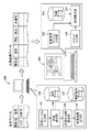
A.システム構成:
図1は実施例としての座標付与システムの概略構成を示す説明図である。本実施例では、ネットワークで接続された2つのコンピュータ100、200を用いてシステムを構成する場合を例示する。単一のコンピュータで構成するものとしてもよい。コンピュータ100は、住所に基づいて位置座標を付与する座標付与装置として機能する。コンピュータ200は座標付与を依頼する利用者の端末として機能し、コンピュータ100に対して顧客の住所ファイルを送信するとともに、位置座標の付与結果を受信する。また、得られた位置座標に基づいて、地図上に顧客の住居を表示する機能も奏する。
【0023】
なお、以下の実施例では、説明の便宜上、「住居」という用語を用いるが、これは必ずしも居住している建築物のみを指すものではなく、住所が与えられている建造物一般を意味している。また、「顧客」という用語を用いるが、必ずしも営業上の関係がある者に限られず、位置座標を付与する対象となる者一般を意味している。
【0024】
コンピュータ100は、図示する機能ブロックが、ソフトウェア的に構成されている。また、住所と位置座標とを対応づけて記憶した住所データベース106、および住所と電話番号とを対応づけて記憶した電話番号データベース107を備えている。住所データベース106、電話番号データベース107は、コンピュータ100と別体のサーバやCD−ROMなどの記録媒体によって提供するものとしてもよい。本実施例では、位置座標として緯度、経度を用いるものとしたが、直交座標など種々の座標を用いることが可能である。また、緯度、経度の表示方式は、任意に設定可能である。
【0025】
住所ファイル入力部102は、利用者のコンピュータ200からネットワークを介して住所ファイルを入力する機能を奏する。住所ファイルとは、顧客と住所とを対応づけたファイルである。例えば、利用者のコンピュータ200に対して、ブラウザで閲覧可能なインタフェース画面を提供し、これを通じて住所ファイルを取得する方法を採ることができる。
【0026】
位置検索部104は、住所ファイルに基づき位置座標を検索する機能を奏する。この検索は、適宜、住所データベース106を参照して行う。位置検索部104は、併せて、電話番号データベース107を検索する機能も奏する。正確性指標設定部108は、位置座標の検索結果に対し、正確性を判断するための正確性指標を設定する。位置座標出力部110は、位置座標および正確性指標を位置座標ファイルの形式で利用者のコンピュータ200に送信する機能を奏する。
【0027】
利用者のコンピュータ200は、図示する機能ブロックが、ソフトウェア的に構成されている。ここでは、位置座標に基づき顧客の住居を地図上に表示するための機能ブロックのみを示した。また、地図を表示するための地図データベース204を備えている。地図データベース204は、コンピュータ200と別体のサーバやCD−ROMなどの記録媒体によって提供するものとしてもよい。
【0028】
位置座標ファイル入力部202は、コンピュータ100から送信された位置座標ファイルを読み込む機能を奏する。コマンド入力部206は、キーボード、マウスなどの操作に基づき、地図表示を行うべき地域の指定、表示スケールなどに関する種々のコマンドを入力する。地図表示部208は、地図データベース204を参照して、地図を表示するとともに、位置座標ファイルに基づき、顧客の住居を地図上に表示する。
【0029】
B.位置座標設定処理:
図2は位置座標設定処理のフローチャートである。座標付与装置として機能するコンピュータ100のCPUが実行する処理である。
【0030】
この処理が開始されると、CPUは住所ファイルを入力し(ステップS10)、位置検索処理およびフラグ設定処理を行う(ステップS12)。位置検索は、先に示した住所データベース106を参照して行う。ここで、住所データベース106は、必ずしも全ての住所と位置座標が対応づけられているとは限らない。また、住所ファイルに登録されている住所に誤りが含まれている場合もある。これらの要因により、住所と完全に一致する位置座標が得られない場合、CPUは行政区画の階層に応じて住所条件を緩和して位置座標の検索を行う。フラグは、位置座標の特定がいずれの階層で行われたかを示す情報である。かかるフラグは、位置座標の正確性を判断するための正確性指標となり得る。
【0031】
図中にフラグの設定例を示した。
フラグ=0は、住所データベース106において、号番まで、住所が完全に一致した位置座標が得られたことを意味する。
フラグ=1は、住所情報の近隣の号番で位置座標が得られたことを意味する。
フラグ=2は、街区単位で位置座標が得られたことを意味する。この場合には、街区内に設定された代表点の位置座標が与えられる。
フラグ=3は、丁目、字単位で設定された代表点の位置座標が与えられたことを意味する。
フラグ=4は、町村大字単位で設定された代表点の位置座標が与えられたことを意味する。
フラグ=5は、市区郡単位で設定された代表点の位置座標が与えられたことを意味する。
【0032】
次に、CPUは、位置座標の正確性指標を設定するため、条件に一致する住居数を検索し、確率計算を行う(ステップS14)。また、別の観点で正確性指標を設定するため、条件に一致する領域の面積を算出し、その領域を包含する円の半径を算出する(ステップS16)。これらの処理については、後で詳述する。
【0033】
こうして位置座標の検索および正確性指標の設定が完了すると、CPUは、次に最寄りの拠点、および電話番号を検索する(ステップS18)。検索対象となる拠点の種別は、住所ファイルの提供と併せて利用者が指定することができる。例えば、拠点として駅を検索する旨の設定がなされている場合には、ステップS12で設定された位置座標に基づき、その周辺の最寄りの駅が検索される。拠点としては、その他、利用者の営業に関する支店などを設定することが可能である。電話番号の検索は、先に説明した電話番号データベース107を参照して行われる。座標付与時と同様、住所の一致性を緩和して検索するものとしても構わないが、電話番号という情報の性質上、本実施例では、住所と完全一致する電話番号を提示するものとした。完全一致する電話番号が得られない場合には、電話番号の提示を行わないものとした。拠点および電話番号の検索処理は、ユーザの設定等により、省略しても構わない。
【0034】
CPUは以上で得られた情報、即ち、位置座標、フラグ、2種類の正確性指標、最寄りの拠点、および電話番号を対応づけて、位置座標ファイルとして出力する(ステップS20)。フラグ、2種類の正確性指標、最寄りの拠点、電話番号については、必ずしも全てを出力する必要はなく、少なくとも一部を適宜選択可能である。
【0035】
C.正確性指標:
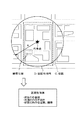
C1.住居数に基づく正確性指標:
図3は住居数に基づく正確性指標を例示する説明図である。この指標は、位置座標設定処理(図2)のステップS14で設定される正確性指標に相当する。
【0036】
図の上方には、位置座標の付与対象となる顧客住居Bの周辺の概略地図を表示した。図示する通り、顧客住居Bは、いわゆる袋小路に沿って存在する6件のうちの1件である。このように袋小路に沿った住居では、同一の号番で住所が与えられていることがある。かかる場合には、顧客住居Bの位置座標が号番までの一致(フラグ=0)で得られたとしても、その条件に該当する住居は6件存在することになる。従って、図の下方に示す通り、住居数「6件」、または位置座標が顧客住居Bに該当する確率「1/6」が正確性指標となる。いずれを用いても構わない。
【0037】
図3では、号番までが一致する住居が複数存在する場合を例示したが、住居数に基づく正確性指標は、その他の階層についても同様に設定可能である。例えば、街区単位で位置座標が得られた場合(フラグ=2)には、その街区内に存在する住居数、または住居数に基づいて得られる確率を正確性指標として用いることができる。
【0038】
C2.領域の広さに基づく正確性指標:
図4は領域の広さに基づく正確性指標を例示する説明図である。この指標は、位置座標設定処理(図2)のステップS16で設定される正確性指標に相当する。
【0039】
図中では、顧客住居に対し、街区Cを単位として(フラグ2)で位置座標が得られた場合を例示した。図の上方には、顧客住居および街区C近傍の地図を示した。一般に、街区が広い程、得られた位置座標と顧客住居の位置座標とのずれが大きい可能性が高いと言えるから、街区の広さを正確性指標として用いることができる。かかる正確性指標としては、例えば、図の下方に示すように、街区Cの面積、街区Cにほぼ外接する円の半径Rなどを用いることができる。街区Cの面積に等価な円の半径を用いるものとしてもよい。円形に限らず、矩形など種々の領域を適用可能である。また、併せて住居数、確率に基づく正確性指標を設定してもよい。
【0040】
図4では、街区単位で位置座標が得られた場合を例示したが、その他の階層で位置座標が得られた場合も同様にして正確性指標を設定することができる。
【0041】
D.地図表示:
図5は地図表示処理のフローチャートである。利用者のコンピュータ200のCPUが実行する処理である。
【0042】
この処理が開始されると、CPUは、表示位置、スケールの指定を入力する(ステップS30)。また、住居の選択条件を入力する(ステップS32)。選択条件は、正確性の指標に基づいて設定される。例えば、表示対象とすべきフラグの値または範囲を選択条件として与えることができる。
【0043】
CPUは、この選択条件に適合する住居を抽出し(ステップS34)、地図表示を行う(ステップS36)。住居の抽出および表示は、位置座標ファイルに基づいて行うことができる。つまり、位置座標ファイルに記録された正確性が上記選択条件を満足する住居を表示対象として抽出し、その住居に対して記録された位置座標に住居用のマークを表示するのである。
【0044】
図中に選択条件に応じた表示態様の差違を例示した。例えば、選択条件がフラグ=0、フラグ≦2の2通りを考える。図中の例では、フラグ=0の場合には、この条件に該当する2件の住居につき、ピン状のマークが表示される。フラグ≦2の場合には、フラグ=0、1、2に該当する多数の住居が表示される。フラグ0、1、2でマークの形状、色等を変えても良い。ここでは、フラグを選択条件とする場合を例示したが、その他の正確性指標を選択条件として用いても良い。
【0045】
E.効果:
以上で説明した本実施例のシステムによれば、位置座標とともに、正確性の指標が提示される。従って、利用者は、設定された位置座標の正確性を客観的に判断することができ、その誤差などを考慮した上で位置座標を活用することができる。
【0046】
また、本実施例のシステムでは、最寄りの拠点および電話番号を併せて提示する。従って、拠点と関連づけて顧客の分布を確認したり、電話連絡を取ったりするなど、位置座標を更に有効活用することが可能となる。この場合、位置座標の正確性指標は、最寄りの拠点についての正確性指標としても利用することが可能である。
【0047】
地図表示時には、正確性指標に基づく選択条件に応じて、住居の表示を制御することができるため、正確性指標に応じて住居の分布を視覚的に把握することができる。
【0048】
F.変形例:
実施例では、住所ファイルから位置座標を検索するとともに正確性指標を設定する場合を例示した。本発明は、住所ファイルに対して位置座標が既に設定されたファイルに対して、正確性指標を設定するシステムとして構成することも可能である。かかる場合において、図2のステップS12中に示したフラグが設定済みのデータについては、ステップS14以降の処理を行うことにより正確性指標を設定することができる。フラグが未設定の場合には、図2の処理全体を再実行することにより正確性指標を設定することができる。
【0049】
実施例において、正確性の指標表示は、種々の態様を採ることができる。図5で示した地図表示の他、図1に示した表形式で提示するものとしてもよい。図5では、正確性指標に基づく選択条件を例示したが、最寄りの拠点に基づく選択条件を併せて用いるものとしてもよい。
【0050】
以上、本発明の種々の実施例について説明したが、本発明はこれらの実施例に限定されず、その趣旨を逸脱しない範囲で種々の構成を採ることができることはいうまでもない。例えば、以上の制御処理はソフトウェアで実現する他、ハードウェア的に実現するものとしてもよい。
【図面の簡単な説明】
【図1】実施例としての座標付与システムの概略構成を示す説明図である。
【図2】位置座標設定処理のフローチャートである。
【図3】住居数に基づく正確性指標を例示する説明図である。
【図4】領域の広さに基づく正確性指標を例示する説明図である。
【図5】地図表示処理のフローチャートである。
【符号の説明】
100…コンピュータ
102…住所ファイル入力部
104…位置検索部
106…住所データベース
107…電話番号データベース
108…正確性指標設定部
110…位置座標出力部
200…コンピュータ
202…位置座標ファイル入力部
204…地図データベース
206…コマンド入力部
208…地図表示部[0001]
BACKGROUND OF THE INVENTION
The present invention relates to a method for associating position coordinates based on address information.
[0002]
[Prior art]
Conventionally, in the examination of marketing and sales plans, distributions obtained by showing customer residences on a map are effectively used. In recent years, since electronic maps have become widespread, a method of displaying a customer's residence distribution on an electronic map based on data for managing customer addresses and the like has also been adopted. In order to display the customer's residence distribution on the electronic map, it is necessary to give position coordinates such as latitude and longitude to the customer's address in advance. Position coordinates are assigned using a database that associates addresses with position coordinates.
[0003]
[Problems to be solved by the invention]
However, the above database does not necessarily cover all addresses. Also, the customer's address itself may be inaccurate. For these reasons, accurate position coordinates may not be given to customer addresses. Conventionally, when a position coordinate that completely matches the customer's address cannot be obtained, a representative point given to a chome, a town, or the like may be given.
[0004]
As described above, when position coordinates that do not necessarily correspond accurately to the customer's address are given, the credibility and effectiveness of the position coordinates may be impaired. In consideration of such a problem, an object of the present invention is to improve the effectiveness of a position coordinate given based on an address.
[0005]
[Means for solving the problems and their functions and effects]
The present invention is configured as a coordinate assigning device that associates position coordinates based on address information by including an input unit, a coordinate specifying unit, an index setting unit, and an output unit.
[0006]
The input unit inputs address information. Address information may be input on a case-by-case basis, or a plurality of addresses may be input together.
[0007]
The coordinate specifying unit searches for the position coordinates of the representative point corresponding to the input address information. For this search, a database in which address information and position coordinates are associated in advance is referred to. The search is also performed with partial matching allowed. That is, when the position coordinates completely corresponding to the address information cannot be obtained, the search is performed by relaxing the conditions such as the address and the chome. Under the relaxed condition, for example, the position coordinates of the representative point with respect to a certain region corresponding to the condition can be given. Partial match means that the search is performed with relaxed conditions so as to include at least the residence corresponding to the address information.
[0008]
The index setting unit sets an accuracy index representing the accuracy of the specific result obtained in this way. The accuracy index can take various settings, as will be exemplified later.
[0009]
The output unit outputs position coordinates and an accuracy index. As long as the position coordinates and the accuracy index are output as associated data, the output mode is not limited.
[0010]
According to the coordinate providing device of the present invention, an accuracy index is given to the position coordinates. Therefore, it is possible to provide a determination material for objectively determining the credibility of the assigned position coordinates to the user. The user can effectively use the position coordinates based on this credibility.
[0011]
In the coordinate assigning device of the present invention, the accuracy index can take various forms.
[0012]
As a 1st aspect, the number of residences which satisfy the conditions in a search can be acquired from a database, and an accuracy index can be set based on this number of residences. The number of residences may be used, or the probability of adaptation expressed using the number of residences as a denominator may be used.
[0013]
As a 2nd aspect, an accuracy index can be set based on the parameter showing the area of the area including the place where the residence which satisfies the conditions in search exists. The area of the region may be used, or the diameter of a circle including the region or a circle having an area equivalent to the region may be used. The area is not limited to a circle, and various shapes such as a rectangle can be applied.
[0014]
When the address information is hierarchically configured based on administrative districts, as a third aspect, an accuracy index can be set based on the administrative district layer used for the search. The address information is usually hierarchically composed of “prefectures”, “city counties”, “machimura large letters”, “chome letters”, and the like. In such a configuration, the width of the corresponding region varies depending on the hierarchy. Therefore, the hierarchy used for the search can be used as an accuracy index. For example, it is possible to determine that the position coordinates given in the “chome character” hierarchy are more accurate than the position coordinates given in the “machimura large letter” hierarchy.
[0015]
In the coordinate assigning device of the present invention, in addition to the accuracy index, a specific type of base name near the representative point may be output. Such a base name can be extracted by referring to the map database. The specific type can be arbitrarily set. For example, facilities related to transportation such as a station or a bus stop may be extracted. Further, when there are many branches for a specific company, each branch may be extracted as a base. Moreover, it is good also as what attaches a telephone number with a coordinate. The telephone number can be obtained by referring to a telephone number database in which address information and a telephone number are associated in advance. By providing these pieces of information together, position coordinates can be used more effectively in business plans and the like.
[0016]
The coordinate assigning device of the present invention can be configured using a computer that includes various databases and operates stand-alone. Moreover, you may comprise as a system which connected the some computer with the network. You may comprise as a server which receives input of address information etc. via a network, and returns position coordinates etc.
[0017]
The present invention can also be configured as a map display device that displays a representative point on a map based on a position coordinate database in which the position coordinates of the representative point are associated with an accuracy index. As a position coordinate database, the database which stored the data produced | generated by the above-mentioned coordinate provision apparatus can be used, for example.
[0018]
In such a map display device, it is preferable that the representative point to be displayed can be controlled based on the accuracy index. This control inputs a selection condition for selecting a representative point to be displayed based on an accuracy index, extracts a representative point corresponding to the selection condition from the position coordinate database, and superimposes the representative points extracted together with the map. It is realized by displaying. By controlling the display in this way, the position of the representative point can be visually grasped according to the accuracy index.
[0019]
The present invention can be configured in various modes as well as the above-described coordinate providing device and map display device. For example, you may comprise as the coordinate provision method which provides the coordinate corresponding to address information using a computer. Moreover, you may comprise as a computer program for making a computer implement | achieve this coordinate provision function, and a recording medium which recorded this computer program.
[0020]
Here, as a recording medium, a flexible disk, a CD-ROM, a DVD, a magneto-optical disk, an IC card, a ROM cartridge, a punch card, a printed matter on which a code such as a barcode is printed, an internal storage device of a computer (RAM or ROM) A variety of computer-readable media, such as memory) and external storage devices.
[0021]
DETAILED DESCRIPTION OF THE INVENTION
Embodiments of the present invention will be described in the following order.
A. System configuration:
B. Position coordinate setting process:
C. Accuracy indicator:
C1. Accuracy index based on the number of houses:
C2. Accuracy indicators based on area size:
D. Map display:
E. effect:
F. Variations:
[0022]
A. System configuration:
FIG. 1 is an explanatory diagram showing a schematic configuration of a coordinate providing system as an embodiment. In this embodiment, a case where a system is configured by using two
[0023]
In the following examples, for convenience of explanation, the term “residence” is used, but this does not necessarily mean only the building in which it resides, but it means a general building where an address is given. Yes. Further, although the term “customer” is used, it is not necessarily limited to a person who has a business relationship, but means a general person to whom position coordinates are given.
[0024]
In the
[0025]
The address
[0026]
The
[0027]
In the user's
[0028]
The position coordinate
[0029]
B. Position coordinate setting process:
FIG. 2 is a flowchart of the position coordinate setting process. This is a process executed by the CPU of the
[0030]
When this process is started, the CPU inputs an address file (step S10), and performs a position search process and a flag setting process (step S12). The position search is performed with reference to the
[0031]
An example of flag setting is shown in the figure.
Flag = 0 means that in the
Flag = 1 means that the position coordinates have been obtained with the neighboring number of the address information.
Flag = 2 means that the position coordinates are obtained in block units. In this case, the position coordinates of the representative point set in the block are given.
Flag = 3 means that the position coordinates of the representative point set in units of characters and characters are given.
Flag = 4 means that the position coordinates of the representative point set in the unit of capital letters are given.
Flag = 5 means that the position coordinates of the representative point set in units of municipalities are given.
[0032]
Next, in order to set the accuracy index of the position coordinates, the CPU searches for the number of residences that match the condition and calculates the probability (step S14). In order to set an accuracy index from another viewpoint, the area of a region that matches the condition is calculated, and the radius of a circle that includes the region is calculated (step S16). These processes will be described in detail later.
[0033]
When the search for the position coordinates and the setting of the accuracy index are completed in this way, the CPU next searches for the nearest base and telephone number (step S18). The type of base to be searched can be specified by the user together with the provision of the address file. For example, when a setting is made to search for a station as a base, the nearest station nearby is searched based on the position coordinates set in step S12. In addition, as a base, it is possible to set a branch concerning the sales of the user. The telephone number search is performed with reference to the
[0034]
The CPU associates the information obtained above, that is, the position coordinates, flags, two types of accuracy indexes, the nearest base, and the telephone number, and outputs them as a position coordinate file (step S20). It is not always necessary to output all of the flags, the two types of accuracy indicators, the nearest base, and the telephone number, and at least a part can be selected as appropriate.
[0035]
C. Accuracy indicator:
C1. Accuracy index based on the number of houses:
FIG. 3 is an explanatory diagram illustrating an accuracy index based on the number of residences. This index corresponds to the accuracy index set in step S14 of the position coordinate setting process (FIG. 2).
[0036]
In the upper part of the figure, a schematic map around the customer residence B to which position coordinates are assigned is displayed. As illustrated, the customer residence B is one of six cases existing along a so-called bag path. As described above, in the residence along the culvert path, an address may be given with the same number. In such a case, even if the position coordinates of the customer residence B are obtained by coincidence up to the number (flag = 0), there are six residences that satisfy the condition. Therefore, as shown in the lower part of the figure, the number of residences “6” or the probability “1/6” that the position coordinate corresponds to the customer residence B is an accuracy index. Any of them may be used.
[0037]
Although FIG. 3 illustrates the case where there are a plurality of residences that match up to the issue numbers, the accuracy index based on the number of residences can be similarly set for other tiers. For example, when the position coordinates are obtained in block units (flag = 2), the number of residences existing in the block or the probability obtained based on the number of residences can be used as an accuracy index.
[0038]
C2. Accuracy indicators based on area size:
FIG. 4 is an explanatory diagram illustrating an accuracy index based on the area size. This index corresponds to the accuracy index set in step S16 of the position coordinate setting process (FIG. 2).
[0039]
In the figure, the case where the position coordinates are obtained with the block C as a unit (flag 2) is illustrated for the customer residence. In the upper part of the figure, a map of the customer residence and the neighborhood of the block C is shown. In general, it can be said that there is a high possibility that the larger the block is, the larger the difference between the obtained position coordinates and the position coordinates of the customer residence is. Therefore, the area of the block can be used as an accuracy index. As the accuracy index, for example, as shown in the lower part of the figure, the area of the block C, the radius R of a circle that is almost circumscribed by the block C, and the like can be used. A circle radius equivalent to the area of the block C may be used. Not only a circular shape but also various regions such as a rectangular shape can be applied. In addition, an accuracy index based on the number of residences and the probability may be set.
[0040]
Although FIG. 4 illustrates the case where the position coordinates are obtained for each block, the accuracy index can be set in the same manner when the position coordinates are obtained at other levels.
[0041]
D. Map display:
FIG. 5 is a flowchart of the map display process. This process is executed by the CPU of the user's
[0042]
When this process is started, the CPU inputs the designation of the display position and scale (step S30). Further, the housing selection conditions are input (step S32). The selection condition is set based on an accuracy index. For example, a flag value or range to be displayed can be given as a selection condition.
[0043]
The CPU extracts a residence that meets this selection condition (step S34) and displays a map (step S36). The extraction and display of the residence can be performed based on the position coordinate file. That is, a residence whose accuracy recorded in the position coordinate file satisfies the above selection condition is extracted as a display target, and a residence mark is displayed at the position coordinate recorded for that residence.
[0044]
The difference in the display mode according to the selection conditions is illustrated in the figure. For example, consider two selection conditions of flag = 0 and flag ≦ 2. In the example in the figure, when flag = 0, a pin-shaped mark is displayed for two houses corresponding to this condition. In the case of flag ≦ 2, a large number of residences corresponding to flag = 0, 1, 2 are displayed. The shape, color, etc. of the mark may be changed with the flags 0, 1 and 2. Here, the case where the flag is used as the selection condition is illustrated, but another accuracy index may be used as the selection condition.
[0045]
E. effect:
According to the system of the present embodiment described above, an accuracy index is presented together with the position coordinates. Therefore, the user can objectively determine the accuracy of the set position coordinates, and can use the position coordinates in consideration of the error.
[0046]
In the system of the present embodiment, the nearest base and telephone number are also presented. Therefore, it is possible to further effectively utilize the position coordinates, such as checking the distribution of customers in association with the bases, or contacting the telephone. In this case, the accuracy index of the position coordinates can be used as an accuracy index for the nearest base.
[0047]
At the time of map display, since the display of the residence can be controlled according to the selection condition based on the accuracy index, the distribution of the residence can be visually grasped according to the accuracy index.
[0048]
F. Variations:
In the embodiment, the case where the position coordinate is searched from the address file and the accuracy index is set is illustrated. The present invention can also be configured as a system for setting an accuracy index for a file whose position coordinates are already set for an address file. In such a case, for the data for which the flag shown in step S12 of FIG. When the flag is not set, the accuracy index can be set by re-execution of the entire process of FIG.
[0049]
In the embodiment, the accuracy index display can take various forms. In addition to the map display shown in FIG. 5, it may be presented in the table format shown in FIG. Although FIG. 5 illustrates the selection condition based on the accuracy index, the selection condition based on the nearest base may be used together.
[0050]
As mentioned above, although the various Example of this invention was described, it cannot be overemphasized that this invention is not limited to these Examples, and can take a various structure in the range which does not deviate from the meaning. For example, the above control processing may be realized by hardware in addition to software.
[Brief description of the drawings]
FIG. 1 is an explanatory diagram showing a schematic configuration of a coordinate providing system as an embodiment.
FIG. 2 is a flowchart of a position coordinate setting process.
FIG. 3 is an explanatory diagram illustrating an accuracy index based on the number of residences.
FIG. 4 is an explanatory diagram illustrating an accuracy index based on the area size;
FIG. 5 is a flowchart of map display processing.
[Explanation of symbols]
DESCRIPTION OF
Claims (9)
住所情報を入力する入力部と、
住所情報と位置座標とを予め対応づけたデータベースを参照して、前記入力された住所情報に対応する代表点の位置座標を、部分一致も許容して検索することにより特定する座標特定部と、
前記位置座標の特定結果の正確性を表す正確性指標を設定する指標設定部と、
前記位置座標および正確性指標とを出力する出力部と、
を備え、
前記指標設定部は、前記検索における条件を満足する住居数を前記データベースから取得し、該住居数に基づいて前記正確性指標を設定することを特徴とする座標付与装置。A coordinate assigning device that associates position coordinates based on address information,
An input section for inputting address information;
A coordinate specifying unit for specifying the position coordinates of the representative point corresponding to the input address information by searching with allowing partial matching with reference to a database in which address information and position coordinates are associated in advance;
An index setting unit for setting an accuracy index representing the accuracy of the result of specifying the position coordinates ;
An output unit for outputting the position coordinates and the accuracy index;
With
The coordinate setting device, wherein the index setting unit acquires the number of residences satisfying the condition in the search from the database, and sets the accuracy index based on the number of residences.
住所情報を入力する入力部と、
住所情報と位置座標とを予め対応づけたデータベースを参照して、前記入力された住所情報に対応する代表点の位置座標を、部分一致も許容して検索することにより特定する座標特定部と、
前記位置座標の特定結果の正確性を表す正確性指標を設定する指標設定部と、
前記位置座標および正確性指標とを出力する出力部と、
を備え、
前記住所情報は、行政区画に基づき階層的に構成されており、
前記指標設定部は、前記位置座標の特定に使用された行政区画の層に関する情報に基づいて前記正確性指標を設定することを特徴とする座標付与装置。A coordinate assigning device that associates position coordinates based on address information,
An input section for inputting address information;
A coordinate specifying unit for specifying the position coordinates of the representative point corresponding to the input address information by searching with allowing partial matching with reference to a database in which address information and position coordinates are associated in advance;
An index setting unit for setting an accuracy index representing the accuracy of the result of specifying the position coordinates ;
An output unit for outputting the position coordinates and the accuracy index;
With
The address information is structured hierarchically based on administrative divisions,
The coordinate setting device, wherein the index setting unit sets the accuracy index based on information related to a layer of an administrative district used for specifying the position coordinates .
前記座標付与装置は、ネットワークに接続されたサーバとして構築されており、
前記入力部は、前記ネットワークを介して他のコンピュータから前記サーバに送信された前記住所情報を受信し、
前記出力部は、前記位置座標および正確性指標を前記ネットワークを介して他のコンピュータに出力する、座標付与装置。It is a coordinate provision apparatus of Claim 1 or 2, Comprising:
The coordinate assigning device is constructed as a server connected to a network,
The input unit receives the address information transmitted from the other computer to the server via the network;
The said output part is a coordinate provision apparatus which outputs the said position coordinate and an accuracy parameter | index to another computer via the said network.
地図データベースを参照して、前記代表点の近傍において、予め設定された特定種別の拠点名を抽出する拠点抽出部を備え、
前記出力部は、該拠点名を併せて出力する座標付与装置。It is a coordinate provision apparatus in any one of Claims 1-3,
With reference to a map database, in the vicinity of the representative point, provided with a base extraction unit for extracting a predetermined type of base name,
The output unit is a coordinate assigning device that outputs the base name together.
前記座標特定部は、更に、住所情報と電話番号とを予め対応づけた電話番号データベースを参照して、前記入力された住所情報に対応する電話番号を併せて検索し、
前記出力部は、前記電話番号を併せて出力する座標付与装置。It is a coordinate provision apparatus in any one of Claims 1-4, Comprising:
The coordinate specifying unit further refers to a telephone number database in which address information and a telephone number are associated in advance, and searches for a telephone number corresponding to the input address information,
The output unit is a coordinate assigning device that outputs the telephone number together.
住所情報を入力する工程と、
住所情報と位置座標とを予め対応づけたデータベースを参照して、前記入力された住所情報に対応する代表点の位置座標を、部分一致も許容して検索することにより特定する工程と、
前記位置座標の特定結果の正確性を表す正確性指標を設定する工程と、
前記位置座標および正確性指標とを出力する工程と、
を備え、
前記正確性指標を設定する工程は、前記検索における条件を満足する住居数を前記データベースから取得し、該住居数に基づいて前記正確性指標を設定する工程を含むことを特徴とする座標付与方法。A coordinate assigning method that is executed by a computer and associates position coordinates based on address information,
Inputting address information;
A step of referring to a database in which address information and position coordinates are associated in advance, and specifying the position coordinates of representative points corresponding to the input address information by allowing partial matching and searching;
Setting an accuracy index representing the accuracy of the result of specifying the position coordinates;
Outputting the position coordinates and the accuracy index;
With
Step acquires the number of dwellings to satisfy the condition in the search from the database, coordinates imparting method characterized by comprising the step of setting the accuracy indicator based on the number of dwellings for setting the accuracy index .
住所情報を入力する工程と、
住所情報と位置座標とを予め対応づけたデータベースを参照して、前記入力された住所情報に対応する代表点の位置座標を、部分一致も許容して検索することにより特定する工程と、
前記位置座標の特定結果の正確性を表す正確性指標を設定する工程と、
前記位置座標および正確性指標とを出力する工程と、
を備え、
前記住所情報は、行政区画に基づき階層的に構成されており、
前記正確性指標を設定する工程は、前記位置座標の特定に使用された行政区画の層に関する情報に基づいて前記正確性指標を設定する工程を含むことを特徴とする座標付与方法。A coordinate assigning method that is executed by a computer and associates position coordinates based on address information,
Inputting address information;
A step of referring to a database in which address information and position coordinates are associated in advance, and specifying the position coordinates of representative points corresponding to the input address information by allowing partial matching and searching;
Setting an accuracy index representing the accuracy of the result of specifying the position coordinates;
Outputting the position coordinates and the accuracy index;
With
The address information is structured hierarchically based on administrative divisions,
The step of setting the accuracy index includes the step of setting the accuracy index based on information relating to the administrative division layer used to identify the position coordinates.
住所情報を入力する機能と、
住所情報と位置座標とを予め対応づけたデータベースを参照して、前記入力された住所情報に対応する代表点の位置座標を、部分一致も許容して検索することにより特定する機能と、
前記位置座標の特定結果の正確性を表す正確性指標を設定する機能と、
前記位置座標および正確性指標とを出力する機能と、
をコンピュータにより実現するためのコンピュータプログラムであり、
前記正確性指標を設定する機能は、前記検索における条件を満足する住居数を前記データベースから取得し、該住居数に基づいて前記正確性指標を設定することを特徴とするコンピュータプログラム。A computer program for associating position coordinates based on address information using a computer,
The ability to enter address information;
A function for specifying the position coordinates of the representative point corresponding to the input address information by searching with reference to a database in which the address information and the position coordinates are associated in advance;
A function of setting an accuracy index representing the accuracy of the result of specifying the position coordinates ;
A function of outputting the position coordinates and the accuracy index;
Is a computer program for realizing
The function of setting the accuracy index acquires the number of residences satisfying the conditions in the search from the database, and sets the accuracy index based on the number of residences.
住所情報を入力する機能と、
住所情報と位置座標とを予め対応づけたデータベースを参照して、前記入力された住所情報に対応する代表点の位置座標を、部分一致も許容して検索することにより特定する機能と、
前記位置座標の特定結果の正確性を表す正確性指標を設定する機能と、
前記位置座標および正確性指標とを出力する機能と、
をコンピュータにより実現するためのコンピュータプログラムであり、
前記住所情報は、行政区画に基づき階層的に構成されており、
前記正確性指標を設定する機能は、前記位置座標の特定に使用された行政区画の層に関する情報に基づいて前記正確性指標を設定することを特徴とするコンピュータプログラム。A computer program for associating position coordinates based on address information using a computer,
The ability to enter address information;
A function for specifying the position coordinates of the representative point corresponding to the input address information by searching with reference to a database in which the address information and the position coordinates are associated in advance;
A function of setting an accuracy index representing the accuracy of the result of specifying the position coordinates ;
A function of outputting the position coordinates and the accuracy index;
Is a computer program for realizing
The address information is structured hierarchically based on administrative divisions,
The computer program characterized in that the function of setting the accuracy index sets the accuracy index based on information relating to the administrative division layer used to identify the position coordinates .
Priority Applications (1)
| Application Number | Priority Date | Filing Date | Title |
|---|---|---|---|
| JP2002022818A JP4249929B2 (en) | 2002-01-31 | 2002-01-31 | Matching method of address information and position coordinates |
Applications Claiming Priority (1)
| Application Number | Priority Date | Filing Date | Title |
|---|---|---|---|
| JP2002022818A JP4249929B2 (en) | 2002-01-31 | 2002-01-31 | Matching method of address information and position coordinates |
Related Child Applications (1)
| Application Number | Title | Priority Date | Filing Date |
|---|---|---|---|
| JP2005022407A Division JP4276186B2 (en) | 2005-01-31 | 2005-01-31 | Coordinate assigning device, coordinate assigning method, and computer program |
Publications (3)
| Publication Number | Publication Date |
|---|---|
| JP2003223450A JP2003223450A (en) | 2003-08-08 |
| JP2003223450A5 JP2003223450A5 (en) | 2005-08-18 |
| JP4249929B2 true JP4249929B2 (en) | 2009-04-08 |
Family
ID=27745720
Family Applications (1)
| Application Number | Title | Priority Date | Filing Date |
|---|---|---|---|
| JP2002022818A Expired - Fee Related JP4249929B2 (en) | 2002-01-31 | 2002-01-31 | Matching method of address information and position coordinates |
Country Status (1)
| Country | Link |
|---|---|
| JP (1) | JP4249929B2 (en) |
Families Citing this family (5)
| Publication number | Priority date | Publication date | Assignee | Title |
|---|---|---|---|---|
| JP2006338158A (en) * | 2005-05-31 | 2006-12-14 | Zenrin Co Ltd | Position coordinate imparting device |
| JP2006338159A (en) * | 2005-05-31 | 2006-12-14 | Zenrin Co Ltd | Position coordinate imparting device |
| JP4822986B2 (en) * | 2006-08-25 | 2011-11-24 | アルパイン株式会社 | Navigation device and destination search method |
| JP2011192123A (en) * | 2010-03-16 | 2011-09-29 | Yanmar Co Ltd | Chemical spray management system |
| JP5579141B2 (en) * | 2011-09-06 | 2014-08-27 | 日本電信電話株式会社 | Document specialty level judging device, method and program for region |
-
2002
- 2002-01-31 JP JP2002022818A patent/JP4249929B2/en not_active Expired - Fee Related
Also Published As
| Publication number | Publication date |
|---|---|
| JP2003223450A (en) | 2003-08-08 |
Similar Documents
| Publication | Publication Date | Title |
|---|---|---|
| US8782055B2 (en) | Geospatial object property assessment apparatus, assessment system, editor apparatus and method of assessing property of a geospatial object | |
| US8799074B2 (en) | Methods and apparatus for performing enhanced queries for items such as maps and geospatial data | |
| JP7023821B2 (en) | Information retrieval system | |
| JP2991290B2 (en) | Map database management method and system | |
| US20030158668A1 (en) | System and method of geospatially mapping topological regions and displaying their attributes | |
| JP5857134B2 (en) | User-based proactive content correction and enhancement for geodata | |
| US8341156B1 (en) | System and method for identifying erroneous business listings | |
| US20090112474A1 (en) | View-Independent Tagging of Geospatial Entities in Images | |
| US11216499B2 (en) | Information retrieval apparatus, information retrieval system, and information retrieval method | |
| JP2011107874A (en) | Facility information provision device | |
| CN102175255B (en) | The automated prioritization of map object | |
| US20120143598A1 (en) | Server, dictionary creation method, dictionary creation program, and computer-readable recording medium recording the program | |
| JP4249929B2 (en) | Matching method of address information and position coordinates | |
| EP3150962B1 (en) | Indexing and searching of a second soi object with respect to a first soi object | |
| CN109917456B (en) | Method and system for quickly extracting seismic information | |
| JP4276186B2 (en) | Coordinate assigning device, coordinate assigning method, and computer program | |
| KR101459872B1 (en) | Indexing system of space object for combination object of SOI and content | |
| JP2003223453A (en) | Matching method for address information with position coordinates | |
| CN110909252B (en) | Community activity recommendation method and device based on big data | |
| de Armas García et al. | Deployment of a National Geocoding Service: Cuban Experience. | |
| KR101233902B1 (en) | Server, dictionary creation method, and computer-readable recording medium for recording dictionary creation program | |
| JP4997978B2 (en) | Address information management program, address information management method, and address information management apparatus | |
| JPH11120196A (en) | Information retrieving device | |
| CN117556158B (en) | User peripheral location visualization method and system for coupling place name label and contour line | |
| JP3492185B2 (en) | Creating and updating electronic maps |
Legal Events
| Date | Code | Title | Description |
|---|---|---|---|
| A521 | Request for written amendment filed |
Free format text: JAPANESE INTERMEDIATE CODE: A523 Effective date: 20050131 |
|
| A621 | Written request for application examination |
Free format text: JAPANESE INTERMEDIATE CODE: A621 Effective date: 20050131 |
|
| A131 | Notification of reasons for refusal |
Free format text: JAPANESE INTERMEDIATE CODE: A131 Effective date: 20080219 |
|
| A521 | Request for written amendment filed |
Free format text: JAPANESE INTERMEDIATE CODE: A523 Effective date: 20080414 |
|
| A131 | Notification of reasons for refusal |
Free format text: JAPANESE INTERMEDIATE CODE: A131 Effective date: 20080722 |
|
| A711 | Notification of change in applicant |
Free format text: JAPANESE INTERMEDIATE CODE: A711 Effective date: 20080820 |
|
| A521 | Request for written amendment filed |
Free format text: JAPANESE INTERMEDIATE CODE: A523 Effective date: 20080916 |
|
| A521 | Request for written amendment filed |
Free format text: JAPANESE INTERMEDIATE CODE: A821 Effective date: 20080820 |
|
| A521 | Request for written amendment filed |
Free format text: JAPANESE INTERMEDIATE CODE: A523 Effective date: 20081024 |
|
| TRDD | Decision of grant or rejection written | ||
| A01 | Written decision to grant a patent or to grant a registration (utility model) |
Free format text: JAPANESE INTERMEDIATE CODE: A01 Effective date: 20081224 |
|
| A01 | Written decision to grant a patent or to grant a registration (utility model) |
Free format text: JAPANESE INTERMEDIATE CODE: A01 |
|
| A61 | First payment of annual fees (during grant procedure) |
Free format text: JAPANESE INTERMEDIATE CODE: A61 Effective date: 20090116 |
|
| FPAY | Renewal fee payment (event date is renewal date of database) |
Free format text: PAYMENT UNTIL: 20120123 Year of fee payment: 3 |
|
| R150 | Certificate of patent or registration of utility model |
Free format text: JAPANESE INTERMEDIATE CODE: R150 Ref document number: 4249929 Country of ref document: JP Free format text: JAPANESE INTERMEDIATE CODE: R150 |
|
| FPAY | Renewal fee payment (event date is renewal date of database) |
Free format text: PAYMENT UNTIL: 20120123 Year of fee payment: 3 |
|
| FPAY | Renewal fee payment (event date is renewal date of database) |
Free format text: PAYMENT UNTIL: 20130123 Year of fee payment: 4 |
|
| R250 | Receipt of annual fees |
Free format text: JAPANESE INTERMEDIATE CODE: R250 |
|
| FPAY | Renewal fee payment (event date is renewal date of database) |
Free format text: PAYMENT UNTIL: 20130123 Year of fee payment: 4 |
|
| R250 | Receipt of annual fees |
Free format text: JAPANESE INTERMEDIATE CODE: R250 |
|
| R250 | Receipt of annual fees |
Free format text: JAPANESE INTERMEDIATE CODE: R250 |
|
| R250 | Receipt of annual fees |
Free format text: JAPANESE INTERMEDIATE CODE: R250 |
|
| R250 | Receipt of annual fees |
Free format text: JAPANESE INTERMEDIATE CODE: R250 |
|
| R250 | Receipt of annual fees |
Free format text: JAPANESE INTERMEDIATE CODE: R250 |
|
| R250 | Receipt of annual fees |
Free format text: JAPANESE INTERMEDIATE CODE: R250 |
|
| R250 | Receipt of annual fees |
Free format text: JAPANESE INTERMEDIATE CODE: R250 |
|
| R250 | Receipt of annual fees |
Free format text: JAPANESE INTERMEDIATE CODE: R250 |
|
| R250 | Receipt of annual fees |
Free format text: JAPANESE INTERMEDIATE CODE: R250 |
|
| LAPS | Cancellation because of no payment of annual fees |