JP4028362B2 - Navigation device, route search data update method, and route search data update program - Google Patents
Navigation device, route search data update method, and route search data update program Download PDFInfo
- Publication number
- JP4028362B2 JP4028362B2 JP2002345454A JP2002345454A JP4028362B2 JP 4028362 B2 JP4028362 B2 JP 4028362B2 JP 2002345454 A JP2002345454 A JP 2002345454A JP 2002345454 A JP2002345454 A JP 2002345454A JP 4028362 B2 JP4028362 B2 JP 4028362B2
- Authority
- JP
- Japan
- Prior art keywords
- route
- search data
- route search
- level
- road
- Prior art date
- Legal status (The legal status is an assumption and is not a legal conclusion. Google has not performed a legal analysis and makes no representation as to the accuracy of the status listed.)
- Expired - Fee Related
Links
- 238000000034 method Methods 0.000 title claims description 38
- 238000010586 diagram Methods 0.000 description 33
- 238000004364 calculation method Methods 0.000 description 29
- 230000006870 function Effects 0.000 description 12
- 230000008569 process Effects 0.000 description 5
- 239000000203 mixture Substances 0.000 description 3
- 239000002131 composite material Substances 0.000 description 1
- 238000013500 data storage Methods 0.000 description 1
- 238000001514 detection method Methods 0.000 description 1
- 238000012986 modification Methods 0.000 description 1
- 230000004048 modification Effects 0.000 description 1
- 230000009467 reduction Effects 0.000 description 1
- 230000004044 response Effects 0.000 description 1
- 239000004065 semiconductor Substances 0.000 description 1
- 238000004088 simulation Methods 0.000 description 1
Images


Landscapes
- Navigation (AREA)
- Traffic Control Systems (AREA)
- Instructional Devices (AREA)
Description
【0001】
【発明の属する技術分野】
本発明はナビゲーション装置、経路探索用データ更新方法、及び経路探索用データ更新プログラムに関し、より詳細には、道路網の情報量の多い下位レベルから道路網の情報量の少ない上位レベルに階層化された経路探索用のデータを用いる技術に関する。
【0002】
【従来の技術】
一般に、車載用のナビゲーション装置は、自車の現在位置を検出し、その近傍の地図データをCD、DVD等のデータ記憶媒体から読み出して画面上に表示する。また、画面上には自車位置を示す車両位置マークが表示されており、この車両位置マークを中心に自車の進行にしたがって近傍の地図がスクロールされ、常時自車位置周辺の地図情報がわかるようになっている。
【0003】
また、最近の車載用ナビゲーション装置のほとんどには、利用者が所望の目的地に向かって道路を間違うことなく走行できるようにした経路探索・誘導機能が搭載されている。この経路探索・誘導機能によれば、地図データを用いて出発地から目的地までを結ぶ最もコストの小さな経路が横型探索(BFS)法やダイクストラ法等のシミュレーションを行うことによって探索され、探索された経路に基づいて経路誘導が行われる。このような経路誘導において、従来では、例えば、日本全国すべてのデータを検索することは膨大な計算量となってしまうことから、階層化構造の地図データを用いて、高速に経路探索を行う手法が提案されている。
【0004】
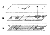
図10は、従来の階層化構造の地図データを用いた経路探索について説明するための図である。なお、図10において、上位レベル(上位階層)、中位レベル(中位階層)、下位レベル(下位階層)の3つの階層を有する階層化構造の地図データを示している。図10に示すように、階層化構造の地図データは、下位レベルの地図データほど、より小さな領域に分割した図葉が設定される。これらの各図葉に対応する地図データには、高速道路や国道に加えて一般道や都道府県道等を含む多数の道路を対象とした詳細な道路情報が含まれる。
【0005】
また、上位レベルの地図データほど、より大きな領域に分割した図葉が設定される。出発地や目的地の周辺については、より詳細な道路情報を含む下位レベルの地図データを用いて、中位レベルの地図データにも共通に含まれている国道等に至るまでの経路が探索される。
【0006】
次に、中位レベルの地図データを用いて、上位レベルの地図データにも共通に含まれている国道や高速道路等に至るまでの経路が探索される。上位レベルの地図データに含まれる道路に至るまでの経路が探索されると、上位レベルの地図データを用いて、主要道路を探索対象として経路探索が行われる。このようにして、全体の検索量を減らして出発地から目的地まで高速な経路探索を可能としている。
【0007】
また、従来のナビゲーションには、ドライバーがよく通る道路を学習(記録)し、ルート計算時にその道路がルートとして選択され易くする機能が提案されている(特許文献1)。この特許文献1のナビゲーション装置は、自車が走行した不案内地域の経路を記憶する記憶手段とを備え、記憶された走行経路を読み出し、目的地入力手段で入力された目的地までの経路を探索する際に記憶された経路を探索候補と格上げして探索手段で探索するようにしたので、自車が走行した不案内地域の経路を記憶することができ、記憶された不案内地域の経路を探索候補にすることができるというものである。
【0008】
【特許文献1】
特開2000−205884号公報
【発明が解決しようとする課題】
しかしながら、特許文献1のナビゲーション装置は、自車が走行した不案内地域の経路を記憶することができ、記憶された不案内地域の経路を探索候補にすることができるというものであるが、この探索には、上述した階層化構造の地図データは用いられていないため、高速に経路を検索することができないという問題がある。
【0009】
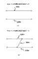
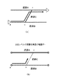
また、階層化構造の地図データを用いる従来のナビゲーション装置に、学習機能を適用しても、次のような問題が生じてしまう。図11は、下位レベル及び上位レベルの2階層の階層化構造の地図データを説明するための図である。図11(a)は、上位レベルにおける階層化構造の地図データを説明するための図である。また、図11(b)は、下位レベルにおける階層化構造の地図データを説明するための図である。なお、図11では、説明の便宜のため図10とは異なり、2階層の階層化構造の地図データを例にとって説明する。図11(a)に示すように、上位レベルの階層化構造の地図データでは、道路Aと、道路Bだけが示されている。一方、図11(b)に示すように、下位レベルの階層化構造の地図データには、道路Aと、道路Bと、更に詳細に、道路Aと道路Bとを結ぶ道路Cが示されている。
【0010】
また、図12は、階層化構造の地図データに学習機能を適用し、これを用いて経路探索を行う場合の問題点を説明するための図である。図12(a)は、学習機能を説明するための図である。また、図12(b)は、上位レベルの階層化構造の地図データと学習機能との関係を説明するための図である。図12(a)に示すように、ドライバーが道路Cを良く使うことによって、ナビゲーション装置は、a→b→c→dの経路をユーザが良く使い経路であるとして学習したとする。
【0011】
しかし、下位レベルの階層化構造のデータには、道路Cが定義されているため、ナビゲーション装置は、a→b→c→dをユーザが良く通る道路として記憶することができるが、図11(b)に示すように上位レベルの階層化構造の地図データには、図11(a)に示す道路Cが定義されていないため、たとえ経路を探索したとしても、ユーザが良く通る道路Cがルートとして選ばれることはない。すなわち、ドライバーがよく通る道路を学習しても、この道路が上位レベルの階層化構造の地図データに含まれていなければ、遠距離離探索などでは、その道路がルートとして選ばれることはないという問題がある。
【0012】
そこで、本発明は上記従来技術の問題点を解決し、ユーザが良く通る道路を学習結果に反映させたルート計算ができるナビゲーション装置、経路探索用データ更新方法、及び経路探索用データ更新プログラムを提供することを目的とする。
【0013】
【課題を解決するための手段】
上述した課題を解決するために、請求項1記載のナビゲーション装置は、目的地までの経路を探索できるナビゲーション装置において、道路網の情報量の多い下位レベルから道路網の情報量の少ない上位レベルに階層化された経路探索用のデータを記憶する第1の記憶部と、自車が走行する経路を第2の記憶部に記憶し、該第2の記憶部に記憶された前記経路に対応する道路が、前記第1の記憶部に記憶される前記下位レベルの経路探索用データに存在するが前記上位レベルの経路探索用データには存在しない場合に、該道路に関する情報を、前記上位レベルの経路探索用データに反映させる制御部と、を有することを特徴とする。
【0014】
請求項1記載の発明によれば、制御部は、第2の記憶部に記憶された経路に対応する道路が、第1の記憶部に記憶された下位レベルの経路探索用データに存在するが、上位レベルの経路探索用データには存在しない場合に、この道路を上位レベルの経路探索用データに反映させるようにしたので、上位レベルの経路探索用データに自車が良く通る道路が登録される。これにより、学習結果を確実に反映させたルート計算を行うことができる。
【0015】
また、請求項2記載のナビゲーション装置は、請求項1記載のナビゲーション装置において、前記制御部は、自車が1回走行した経路を、前記第2の記憶部に記憶することを特徴とする。請求項2記載のナビゲーション装置によれば、制御部は、自車が1回走行した経路を第2の記憶部に記憶するようにしたので、上位レベルの経路探索用データに自車が通った経路が登録される。これにより、学習結果を確実に反映させたルート計算を行うことができる。
【0016】
また、請求項3記載のナビゲーション装置は、請求項1記載のナビゲーション装置において、前記制御部は、自車に誘導した経路から外れて走行した経路を、前記第2の記憶部に記憶することを特徴とする。請求項3記載のナビゲーション装置によれば、制御部は、自車に誘導中した経路から外れて走行した経路を、第2の記憶部に記憶するようにしたので、上位レベルの経路探索用データにこの経路が登録される。これにより、学習結果を確実に反映させたルート計算を行うことができる。
【0017】
また、請求項4記載のナビゲーション装置は、請求項1から3のいずれか一項記載のナビゲーション装置において、前記制御部は、自車が前記経路を通行した回数を計測し、計測した該回数が所定の回数を超えた場合に前記第2の記憶部に前記経路を記憶することを特徴とする。請求項4記載のナビゲーション装置によれば、自車が前記経路を通行した回数を計測し、計測した該回数が所定回数を超えた場合に前記第2の記憶部に前記経路を記憶するようにしたので、自車がよく通行する経路だけが上位レベルの経路探索用データに登録される。これにより、学習結果を確実に反映させたルート計算を行うことができる。
【0018】
また、請求項5記載の経路探索用データ更新方法は、道路網の情報量の多い下位レベルから道路網の情報量の少ない上位レベルに階層化された経路探索用のデータを更新する経路探索用データ更新方法であって、自車が走行する経路を記憶部に記憶する第1の段階と、前記第1の段階により記憶された経路に対応する道路が、前記下位レベルの経路探索用データに存在するが前記上位レベルの経路探索用データに存在しない場合に、該道路に関する情報を、前記上位レベルの経路探索用データに反映させる第2の段階と、有することを特徴とする。
【0019】
請求項5記載の経路探索用データ更新方法によれば、制御部は、自車が走行した経路に対応する道路が、下位レベルの経路探索用データに存在するが、上位レベルの経路探索用データには存在しない場合に、この道路を上位レベルの経路探索用データに反映させるようにしたので、上位レベルの経路探索用データに自車が良く通る道路が登録される。これにより、学習結果を確実に反映させたルート計算を行うことができる。
【0020】
また、請求項6記載の経路探索用データ更新方法は、請求項5記載の経路探索用データ更新方法において、前記第1の段階は、自車が1回走行した経路を、前記記憶部に記憶することを特徴とする。請求項6記載の経路探索用データ更新方法によれば、自車が1回走行した経路を記憶部に記憶するようにしたので、この経路に対応した道路が上位レベルの経路探索用データに自車が通った経路が登録される。これにより、学習結果を確実に反映させたルート計算を行うことができる。
【0021】
また、請求項7記載の経路探索データ更新方法は、請求項5記載の経路探索データ更新方法において、前記第1の段階は、自車に誘導した経路から外れて走行した経路を、前記記憶部に記憶することを特徴とする。請求項7記載の経路探索用データ更新方法によれば、自車に誘導中した経路から外れて走行した経路を、記憶部に記憶するようにしたので、この経路に対応した道路が上位レベルの経路探索用データにこの経路が登録される。これにより、学習結果を確実に反映させたルート計算を行うことができる。
【0022】
また、請求項8経路探索用データ更新方法は、請求項5から7のいずれか一項記載の経路探索用データ更新方法において、前記第1の段階は、自車が走行した経路の走行回数を計測し、計測した該走行回数が所定の回数を超えた場合に前記記憶部に前記経路を記憶することを特徴とする。請求項8記載の経路探索用データ更新方法によれば、自車が前記経路を通行した回数を計測し、計測した該回数が所定回数を超えた場合に前記記憶部に前記経路を記憶するようにしたので、自車がよく通行する経路だけが上位レベルの経路探索用データに登録される。これにより、学習結果を確実に反映させたルート計算を行うことができる。
【0023】
また、請求項9記載の経路探索用データ更新方法は、請求項5から8のいずれか一項記載の経路探索用データ更新方法において、前記第2の段階は、前記上位レベルに反映される道路が接続される道路にノードを追加して分断する第3の段階と、第3の段階により追加した前記ノードに、追加する道路に対応するリンクを接続する第4の段階と、を含むことを特徴とする。
【0024】
請求項9記載の経路探索用データ更新方法によれば、前記第2の段階において、前記上位レベルに反映される道路が接続される道路にノードを追加して分断し、追加した前記ノードに、追加する道路に対応するリンクを接続するようにしたので、実際に経路に対応する道路が、上位レベルの経路探索用データに登録され、これにより、学習結果を確実に反映させたルート計算を行うことができる。
【0025】
また、請求項10記載の経路探索用データ更新プログラムは、道路網の情報量の多い下位レベルから道路網の情報量の少ない上位レベルに階層化された経路探索用のデータを更新するためにコンピュータを、自車が走行する経路を記憶部に記憶する第1の手段と、前記第1の手段により記憶された経路に対応する道路が、前記下位レベルの経路探索用データに存在するが前記上位レベルの経路探索用データに存在しない場合に、該道路に関する情報を、前記上位レベルの経路探索用データに反映させる第2の手段として機能させる。
【0026】
請求項10記載の経路探索用データ更新プログラムによれば、自車が走行する経路に対応する道路が、下位レベルの経路探索用データに存在するが、上位レベルの経路探索用データには存在しない場合に、この道路を上位レベルの経路探索用データに反映させるようにしたので、上位レベルの経路探索用データに自車が良く通る道路が登録される。これにより、学習結果を確実に反映させたルート計算を行うことができる。
【0027】
【発明の実施の形態】
以下、本発明を適用した一実施形態のナビゲーション装置について、図面を参照しながら説明する。なお、本実施の形態では、図11に示したものと同様に説明の便宜のため、下位レベル及び上位レベルの2階層の階層化構造の地図データを用いて説明する。
【0028】
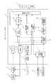
図1は、本実施の形態に係るナビゲーション装置のブロック図である。図1に示すように、ナビゲーション装置100は、ナビゲーションコントローラ1と、記憶部2と、ディスク読取装置3と、リモートコントロール(リモコン)ユニット4と、GPS受信機5と、自律航法センサ6と、ディスプレイ装置7とを有する。ナビゲーションコントローラ1は、ナビゲーション装置100全体を制御する。
【0029】
記憶部2は、上述した階層化構造の地図データと、経路探索用データ等が記録されている。ここで、経路探索用データとは、階層化構造の地図データに対応し、道路網の情報量の多い下位レベルから道路網の情報量の少ない上位レベルに階層化されたデータをいうものとする。また、この記憶部2は、書き込みが可能に構成され、例えば、ハードディスクなどを用いることができる。なお、この記憶部2は、DVD−RW(DVD Rewritable)などの着脱可能なものを用いることもできる。
【0030】
ディスク読取装置3は、記憶部2に記録された地図データと、経路探索用データを読み出す。リモコンユニット4は、利用者が各種の指示を入力する操作部である。このリモコンユニット4は、経路探索指示を与えるための探索キー、経路誘導モードの設定に用いる経路誘導モードキー、目的地入力キー、上下左右のカーソルキー、地図の縮小/拡大キー、表示画面上のカーソル位置にある項目の確定を行う設定キー等の各種操作キーを備えており、キーの操作状態に応じた赤外線信号をナビゲーションコントローラ1に向けて送信する。
【0031】
GPS受信機5および自律航法センサ6は、自車位置と自車方位の検出を行う。このGPS受信機5は、複数のGPS衛星から送られてくる電波を受信して、3次元測位処理あるいは2次元測位処理を行って車両の絶対位置および方位を計算し、これらを測位時刻とともに出力する。また、自律航法センサ6は、車両回転角度を相対方位として検出する振動ジャイロ等の角度センサと、所定走行距離毎に1個のパルスを出力する距離センサとを備えており、車両の相対位置および方位を計算する。
【0032】
ディスプレイ装置7は、地図画像や誘導経路等を表示する。このディスプレイ装置7は、ナビゲーションコントローラ1から出力される描画データに基づいて、自車周辺の地図画像を車両位置マークや出発地マーク、目的地マーク等とともに表示したり、この地図上に誘導経路等を表示したりする。
【0033】
次に、ナビゲーションコントローラ1について説明する。図1に示すように、ナビゲーションコントローラ1は、データバッファ10と、制御部11と、地図描画部12と、VRAM13と、画像合成部14と、車両位置計算部15と、経路探索処理部16と、誘導経路メモリ17と、誘導経路描画部18と、マーク画像描画部19と、リモコン制御部20と、カーソル位置計算部21と、操作画面発生部22とを有する。データバッファ10は、ディスク読取装置3によって記憶部2から読み出された階層化構造の地図データを一時的に格納するものである。
【0034】
制御部11は、経路探索用データを最適に調整するなどの他に以下の機能を有する。ここでの調整とは、下位レベルにしか存在しない道路を上位レベルに反映することをいう。この制御部11は、車両位置計算部15によって自車位置が算出されると、この自車位置を含む所定範囲の地図データの読み出し要求をディスク読取装置3に出力する。
【0035】
また、制御部11は、経路探索処理部16からの要求に応じて、経路探索を行うために必要な階層化構造の地図データの読み出し要求をディスク読取装置3に出力する。また、制御部11は、車両位置計算部15によって算出された自車位置に基づいて、自車が走行した経路を記憶部2に記憶する。また、制御部11は、記憶部2に記憶された経路に対応する道路が、記憶部2に記憶される下位レベルの経路探索用データに存在するが上位レベルの経路探索用データには存在しない場合に、この道路を、上位レベルの経路探索用データに反映させるために、上位レベルの経路探索用データを書き換える。
【0036】
また、制御部11は、自車が1回走行した経路を、記憶部11に記憶するようにしてもよい。また、制御部11は、ナビゲーション装置により自車のユーザに誘導した経路から外れて走行した経路だけを、記憶部2に記憶するようにしてもよい。さらに、制御部11は、経路を記憶部2に記憶する際に、自車が経路を通行した回数を計測し、計測した該回数が所定回数を超えた場合に記憶部2に経路を記憶するようにしてもよい。また、制御部11は、経路探索用データ更新プログラムを記憶部11より読み込んで、経路探索用データを更新する処理を実行する。
【0037】
地図描画部12は、データバッファ10に格納された地図データに含まれる描画ユニットに基づいて、表示に必要な地図描画データを作成する。作成された地図描画データはVRAM13に格納される。画像合成部14は、VRAM13から読み出した地図描画データや、誘導経路描画部18、マーク画像描画部19、操作画面発生部22のそれぞれから出力される描画データを重ねて画像合成を行い、合成描画データをディスプレイ装置7に出力する。
【0038】
車両位置計算部15は、GPS受信機5および自律航法センサ6の各検出データに基づいて自車位置を計算するとともに、計算した自車位置が地図データの道路上にない場合には、自車位置を修正するマップマッチング処理を行う。また、車両位置計算部15は、計算した自車位置を制御部11に出力する。経路探索処理部16は、あらかじめ設定された目的地と出発地との間を所定の条件下で結ぶ走行経路を探索する。
【0039】
例えば、距離最短、時間最短等の各種の条件下で、コストが最小となる走行経路が誘導経路として設定される。経路探索の代表的な手法としては、ダイクストラ法や横型探索法が知られている。このようにして経路探索処理部16によって設定された誘導経路は、出発地から目的地までのノードの集合として表されて誘導経路メモリ17に記憶される。
【0040】
誘導経路描画部18は、経路探索処理部16によって設定されて誘導経路メモリ17に記憶された誘導経路データの中から、その時点でVRAM13に描画された地図エリアに含まれるものを選び出し、誘導経路を地図画像上に重ねて表示するための誘導経路描画データを作成する。マーク画像描画部19は、マップマッチング処理された後の自車位置に車両位置マークを発生したり、所定形状を有するカーソルマークを発生するための描画データを作成する。
【0041】
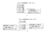
次に、上述した、記憶部2に記憶された経路探索用データについて説明する。図2は、経路探索用データに含まれる各種テーブルの内容を示す図である。なお、以下では、道路上の任意の2点間を結ぶ線をリンクといい、2本以上のリンクを結ぶ隣接点をノードといい、交差点がノードに、道路がリンクにそれぞれ対応する。図2(A)に示すように、経路探索用データは、各図葉に対応した経路計算データフレームA、B、C、D、……を含んでいる。
【0042】
また、各経路計算データフレームは、図2(B)に示すように、a.着目している図葉に含まれる各ノードについての基本情報を含むノードデータフレーム、b.着目している図葉に含まれる各リンクについての基本情報を含むリンクデータフレーム、c.着目している図葉に含まれる各リンクのコスト情報を含むリンクコストデータフレーム、d.経路計算データフレームに含まれるノードで、上位階層にも共通に存在するものについての対応情報を示す上位レベルノード対応データフレーム、e.経路計算データフレームに含まれる規制情報を含む通行コードデータフレーム、f.経路計算データフレームに含まれるノードの座標情報を含むノード座標データフレーム、などを含んでいる。
【0043】
次に、制御部11の動作について説明する。上述したように、制御部11は、記憶部2に記憶された経路に対応する道路が、記憶部2に記憶される下位レベルの経路探索用データに存在するが上位レベルの経路探索用データには存在しない場合に、この道路に関する道路情報を、上位レベルの経路探索用データに反映させるために、上位レベルの経路探索用データの書き換えを行い、上位レベルの経路探索用データに反映させて、ユーザが良く通る道路を学習結果に確実な反映させたルート計算を行う。
【0044】
次に、図9を用いて、この制御部11の経路探索用データの更新動作を説明する。図9は、制御部11の経路探索用データの更新動作を説明するための図である。ステップS101において、制御部11は、上位レベルの検索用データに反映させる道路を特定する。ステップS102において、制御部11は、上位レベルの経路探索用データに反映させる道路が接続される上位レベルの道路に、ノードを追加して分断する。ステップS103において、制御部11は、分断したノード間にリンクを接続して格上げ対象となる道路を上位レベルの経路探索用データに追加する。ステップS104において、制御部11は、対象となる経路探索用データが最上位の経路探索用データかどうかを判断する。
【0045】
ステップ104において、制御部11は、対象となる経路探索用データが最上位の経路探索用データであると判断した場合には、処理を終了する。一方、ステップ104において、制御部11は、対象となる経路探索用データが最上位の経路探索用データでないと判断した場合には、ステップS102に戻り、対象となる経路探索用データが最上位の経路探索用データになるまで、下位レベルから上位レベルまでS102〜S104の処理を繰り返す。これにより、経路探索用データの階層が3以上の場合では、最下位レベルの道路を最上位レベルまで、第2段階のS102〜S104の処理を繰り返すことで最上位レベルの経路探索用データまで一気に格上げすることができる。
【0046】
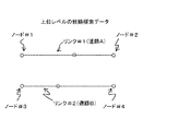
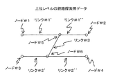
以下、この制御部11の動作を図を用いて説明する。図3は、制御部11の動作を説明するための図であって、ユーザが良く通る道路を上位レベルの経路探索用データに反映させる前の上位レベルの経路探索データを示している。図3に示すように、上位レベルの経路探索データには、道路Aを表すリンク#1、そのリンク#1の両端に、交差点であるノード#1、ノード#2が付いている。また、道路Bを表すリンク#2、そのリンク#2の両端に、交差点であるノード#3、#4が付いている。
【0047】
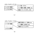
また、図4は、図3に示した上位レベルの経路探索用データのリンクリストと、ノードリストとを示している。なお、上述したようにこの経路探索用データは、記憶部2に格納されている。図4(a)は、上位レベルの経路探索用データのリンクリストを説明するための図である。また、図4(b)は、上位レベルの経路探索用データのノードリストを説明するための図である。図4(a)に示すように、上位レベルの経路探索用データのリンクリストには、道路Aに対応したリンク#1情報と、道路Bに対応したリンク#2情報とが格納されている。
【0048】
また、リンク#1情報には、リンクの長さを決めるリンク長として1000m、リンクの属性を表すリンク属性として国道、2車線など、リンク#1に接続されるノードを表す接続ノードとしてノード#1、ノード#2が示されている。また、図4(b)に示すように、上位レベルの経路探索用データのノードリストには、ノード#1情報、・・・、ノード#4情報が格納されている。また、ノード#1情報には、ノードの座標を表す座標として東経xxxx、北緯yyyyが、ノードの属性を表すノード属性として交差点など、ノードに接続されるリンクを表す接続リンクとしてリンク#1が格納されている。
【0049】
次に、制御部11が、ユーザの良く通る道路を上位レベルの経路探索用データに反映させる動作について説明する。まず、第1段階で、制御部11は、上位レベルの経路探索用データに反映させる道路を特定する。具体的には、制御部11は、車両位置計算部15からのドライバーの走行実績を記憶部2に記憶し、このドライバーの走行実績から、ユーザが良く通る道路を特定する。
【0050】
ここで、ユーザが良く通る道路を特定する手段としては、例えば、単純に車両が1回通った道路を対象として特定したり、車両が誘導中のルートから外れて走行した道路を対象として特定するようにしてもよし、これらの条件を複数回重ねた道路をよく通る道路と判断し、これを反映させる対象として特定するようにしてもよい。また、この条件をレベル毎、例えば、3段階の階層化構造の地図データを用いた場合には、中位レベル、上位レベルのように段階的に反映させる対象を特定するようにしてもよい。例えば、下位レベルの道路を中位レベルに格上げする場合には、ユーザが10回通行した道路を格上げ対象として特定するようにしたり、中位レベルの道路を上位レベルに格上げする場合には、ユーザが30回通行した道路を格上げ対象とするようにすることもできる。
【0051】
次に、第2段階で、制御部11は、記憶部2に記憶された経路に対応する道路が、記憶部2に記憶される下位レベルの経路探索用データに存在するが上位レベルの経路探索用データには存在しない場合に、この道路に関する道路情報を、上位レベルの経路探索用データに反映させる。詳細には、制御部11は、記憶部2にアクセスして、第1段階で格上げ対象となった道路を、下記手順で経路探索用データに反映させるために、まず、格上げ対象となる道路Cが接続する上位レベル道路にノードを追加してリンクを分断する。これを図5を用いて説明する。
【0052】
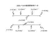
図5は、上位レベルの経路探索用データにノードを追加してリンクの分断について説明するための図である。図5に示すように、制御部11は、図3で示した上位レベルの経路探索用データのリンク#1に、ノード#5を追加して、リンク#1’と、リンク#1’’に分断する。また、制御部11は、図3で示した上位レベルの経路探索用データのリンク#2に、ノード#6を追加して、リンク#2’と、リンク#2’’に分断する。
【0053】
図6は、図5に示した上位レベルの経路探索用データのリンクリストと、ノードリストを説明するための図である。図6(a)は、上位レベルのリンクリストを説明するための図である。図6(a)に示すように、制御部11は、上位レベルの経路探索用データのリンク#1に、ノード#5を追加して、リンク#1’と、リンク#1’’に分断し、上位レベルの経路探索用データのリンク#2に、ノード#6を追加して、リンク#2’と、リンク#2’’に分断することによって、上位レベルのリンクリストに、リンク#1’情報と、リンク#2’情報と、リンク#1’’情報と、リンク#2’’情報とを追加する。また、制御部11は、リンク#1‘情報に、リンク長として600m、リンク属性として国道、2車線など、接続ノードとしてノード#1、ノード#5をそれぞれ格納する。また、制御部11は、リンク#1’情報と同様にして、リンク#2’情報と、リンク#1’’情報と、リンク#2’’情報にも各情報を格納する。
【0054】
また、図6(b)は、上位レベルのノードリストを説明するための図である。図6(b)に示すように、制御部11は、上位レベルの経路探索用データのリンク#1に、ノード#5を追加して、リンク#1’と、リンク#1’’に分断し、上位レベルの経路探索用データのリンク#2に、ノード#6を追加して、リンク#2’と、リンク#2’’に分断することによって、上位レベルのノードリストに、ノード#5情報、ノード#6情報を追加する。また、制御部11は、ノード#5情報には、座標として東経xxxx、北緯yyyyが、ノード属性として交差点など、接続リンクとしてリンク#1’、リンク#1’’を格納する。また、制御部11は、同様に、ノード#6情報にも各情報を格納する。
【0055】
次に、制御部11は、格上げ対象となる道路Cを(リンク#3)を追加する。そして、追加する際のリンク情報に分断に使用したノードを、分断に使用したノード情報に追加するリンクを、それぞれの接続情報として設定する。この動作について図7、図8を用いて説明する。図7は、上位レベルの経路探索用データに道路Cに関する情報の追加について説明するための図である。図7に示すように、制御部11は、上位レベルの経路探索用データに道路Cを追加するために、ノード#5、ノード#6間に、道路Cに対応するリンク#3を追加する。
【0056】
また、図8は、上位レベルの経路探索用データに道路Cを追加する場合のリンクリストと、ノードリストについて説明するための図である。図8(a)は、上位レベルの経路探索用データのリンクリストを説明するための図である。図8(a)に示すように、制御部11は、上位レベルの経路探索用データに道路Cを追加するために、上位レベルの経路探索用データのリンクリストに、リンク#3情報を格納する。また、制御部11は、リンク#3‘情報に、リンク長として500m、リンク属性として国道、2車線など、接続ノードとしてノード#5、ノード#6を格納する。
【0057】
また、図8(b)は、上位レベルのノードリストを説明するための図である。図8(b)に示すように、制御部11は、上位レベルの経路探索用データに道路Cを追加するために、上位レベルの経路探索用データのノード#5情報には、接続リンクとしてリンク#3を追加する。また、制御部11は、上位レベルの経路探索用データのノード#6情報に、リンク#3を追加する。これにより、上位レベルの経路探索用データに道路情報を追加することができる。
【0058】
以上の通り、本実施の形態によれば、制御部11は、記憶部2に記憶された経路に対応する道路が、下位レベルの経路探索用データに存在するが、上位レベルの経路探索用用データには存在しない場合には、この道路を上位レベルの経路検索用データに反映させるようにしたので、上位レベルの経路探索用データに自車が良く通る道路が登録される。これにより、学習結果を確実に反映させたルート計算を行うことができる。
【0059】
また、上記図9に示した制御部11が行う各処理は、経路探索用データ更新プログラムによって実行される。経路探索用データ更新プログラムは、ハードウエアと協働し、ハードウエアと一体となって経路探索用データの更新処理を行う。また、経路探索用データ更新方法は、経路探索用データ更新プログラムとして、FD、HD、CD−ROM等の記憶媒体に記憶されており、それぞれが対応する外部記憶装置に装着され、実行時に読み出されてRAMにロードされる。なお、経路探索用データ更新プログラムが記憶される記憶媒体は、ROM等の半導体メモリでも良い。
【0060】
以上、本発明の一実施の形態を説明した。本発明は上記実施の形態に限定されるものではなく、本発明の要旨の範囲内において種々の変形実施が可能である。
【0061】
【発明の効果】
以上説明した本発明によれば、自車が走行する経路に対応する道路が、下位レベルの経路探索用データに存在するが、上位レベルの経路探索用データには存在しない場合に、この道路を上位レベルの経路探索用データに反映させるようにしたので、上位レベルの経路探索用データに自車が良く通る道路が登録される。これにより、学習結果を確実に反映させたルート計算を行うことができる。
【図面の簡単な説明】
【図1】 本実施の形態に係るナビゲーション装置のブロック図である。
【図2】 経路探索用データに含まれる各種テーブルの内容を示す図である。
【図3】 ユーザが良く通る道路を上位レベルの経路探索用データに反映させる前の上位レベルの経路探索データを示す図である。
【図4】 上位レベルの経路探索用データのリンクリストと、ノードリストを示す図である。
【図5】 上位レベルの経路探索用データにノードを追加してリンクの分断について説明するための図である。
【図6】 上位レベルの経路探索用データのリンクリストと、ノードリストを説明するための図である。
【図7】 上位レベルの経路探索用データに道路Cに関する情報の追加について説明するための図である。
【図8】 上位レベルの経路探索用データに道路Cを追加する場合のリンクリストと、ノードリストについて説明するための図である。
【図9】 制御部の経路探索用データの更新動作を説明するための図である。
【図10】 従来の階層化構造の地図データを用いた経路探索について説明するための図である。
【図11】 下位レベル及び上位レベルの2階層の階層化構造の地図データを説明するための図である。
【図12】 階層化構造の地図データに学習機能を適用し、これを用いて経路探索を行う場合の問題点を説明するための図である。
【符号の説明】
1 ナビゲーションコントローラ
11 制御部
15 車両位置計算部
100ナビゲーション装置[0001]
BACKGROUND OF THE INVENTION
The present invention relates to a navigation device, a route search data update method, and a route search data update program. More specifically, the present invention is hierarchized from a lower level with a large amount of road network information to an upper level with a small amount of road network information. The present invention relates to a technique using data for route search.
[0002]
[Prior art]
In general, an in-vehicle navigation device detects the current position of the own vehicle, reads map data in the vicinity thereof from a data storage medium such as a CD or DVD, and displays the map data on a screen. In addition, a vehicle position mark indicating the vehicle position is displayed on the screen, and a map of the neighborhood is scrolled as the vehicle progresses around the vehicle position mark, so that map information around the vehicle position is always known. It is like that.
[0003]
Also, most of the recent in-vehicle navigation devices are equipped with a route search / guidance function that allows a user to travel to a desired destination without making a mistake on the road. According to this route search / guidance function, the lowest cost route connecting from the starting point to the destination using map data is searched and searched by performing a simulation such as a horizontal search (BFS) method or Dijkstra method. Route guidance is performed on the basis of the route. In such route guidance, conventionally, for example, searching all data in Japan would require a huge amount of calculation, so a method of performing route search at high speed using hierarchically structured map data Has been proposed.
[0004]
FIG. 10 is a diagram for explaining route search using map data having a conventional hierarchical structure. In addition, in FIG. 10, the map data of the hierarchical structure which has three hierarchies, the upper level (upper hierarchy), the middle level (middle hierarchy), and the lower level (lower hierarchy) is shown. As shown in FIG. 10, the map data having a hierarchical structure is set such that the lower-level map data is divided into smaller areas. The map data corresponding to each map leaf includes detailed road information for a large number of roads including general roads and prefectural roads in addition to expressways and national roads.
[0005]
In addition, the higher-level map data is set to a leaf divided into larger areas. In the vicinity of the departure point and destination, the route to the national road etc. that is also included in the medium level map data is searched using lower level map data including more detailed road information. The
[0006]
Next, using the middle level map data, a route to a national road, a highway, or the like that is also commonly included in the higher level map data is searched. When a route to the road included in the higher-level map data is searched, the route search is performed using the higher-level map data as a search target for the main road. In this way, the entire search amount is reduced, and a high-speed route search from the departure point to the destination is enabled.
[0007]
Further, in the conventional navigation, a function is proposed in which a road on which a driver often passes is learned (recorded), and the road is easily selected as a route at the time of route calculation (Patent Document 1). The navigation device of Patent Document 1 includes storage means for storing a route in a non-guided area where the vehicle has traveled, reads out the stored travel route, and displays the route to the destination input by the destination input means. Since the route stored at the time of searching is upgraded as a search candidate and searched by the search means, the route of the unguided area where the vehicle has traveled can be stored, and the stored route of the unguided area Can be made a search candidate.
[0008]
[Patent Document 1]
JP 2000-205884 A
[Problems to be solved by the invention]
However, the navigation device of Patent Document 1 can store the route of the unguided area where the vehicle traveled and can set the stored route of the unguided area as a search candidate. In the search, the map data having the above-described hierarchical structure is not used, and thus there is a problem that a route cannot be searched at high speed.
[0009]
Further, even if the learning function is applied to a conventional navigation device using a hierarchically structured map data, the following problem occurs. FIG. 11 is a diagram for explaining map data having a hierarchical structure of two layers of a lower level and an upper level. FIG. 11A is a diagram for describing map data having a hierarchical structure at a higher level. FIG. 11B is a diagram for explaining map data having a hierarchical structure at a lower level. In FIG. 11, for convenience of explanation, unlike FIG. 10, map data having a two-level hierarchical structure will be described as an example. As shown in FIG. 11A, only the road A and the road B are shown in the map data of the hierarchical structure of the upper level. On the other hand, as shown in FIG. 11 (b), the map data of the lower-level hierarchical structure shows road A and road B, and more specifically road C connecting road A and road B. Yes.
[0010]
FIG. 12 is a diagram for explaining a problem when a learning function is applied to map data having a hierarchical structure and a route search is performed using the learning function. FIG. 12A is a diagram for explaining the learning function. FIG. 12B is a diagram for explaining the relationship between the map data of the higher-level hierarchical structure and the learning function. As shown in FIG. 12A, it is assumed that the navigation device learns that the user frequently uses the route a → b → c → d when the driver frequently uses the road C.
[0011]
However, since the road C is defined in the data of the hierarchical structure at the lower level, the navigation apparatus can store a → b → c → d as a road through which the user often passes. As shown in b), since the road C shown in FIG. 11A is not defined in the map data of the higher level hierarchical structure, even if the route is searched, the road C through which the user often passes is the route. Will not be chosen as. In other words, even if a driver often learns a road, if that road is not included in the map data of the higher-level hierarchical structure, that road will not be selected as a route in long-distance search, etc. There's a problem.
[0012]
Accordingly, the present invention provides a navigation device, a route search data update method, and a route search data update program that can solve the above-described problems of the prior art and perform a route calculation that reflects a road on which a user passes frequently in a learning result. The purpose is to do.
[0013]
[Means for Solving the Problems]
In order to solve the above-described problem, a navigation device according to claim 1 is a navigation device capable of searching for a route to a destination, from a lower level having a large amount of road network information to an upper level having a small amount of road network information. A first storage unit that stores hierarchical route search data and a route on which the host vehicle travels are stored in a second storage unit, and corresponds to the route stored in the second storage unit. When a road exists in the lower-level route search data stored in the first storage unit but does not exist in the higher-level route search data, information on the road is stored in the upper-level route search data. And a control unit for reflecting the data for route search.
[0014]
According to the first aspect of the present invention, the control unit includes a road corresponding to the route stored in the second storage unit in the lower-level route search data stored in the first storage unit. Since the road is reflected in the high-level route search data when it does not exist in the high-level route search data, the road through which the host vehicle passes frequently is registered in the high-level route search data. The Thereby, the route calculation which reflected the learning result reliably can be performed.
[0015]
The navigation device according to claim 2 is characterized in that, in the navigation device according to claim 1, the control unit stores, in the second storage unit, a route traveled by the host vehicle once. According to the navigation device of the second aspect, since the control unit stores the route traveled once by the vehicle in the second storage unit, the vehicle passes the higher-level route search data. The route is registered. Thereby, the route calculation which reflected the learning result reliably can be performed.
[0016]
According to a third aspect of the present invention, in the navigation device according to the first aspect, the control unit stores, in the second storage unit, a route that deviates from a route guided to the host vehicle. Features. According to the navigation device of the third aspect, the control unit stores the route traveled away from the route guided to the host vehicle in the second storage unit. This route is registered. Thereby, the route calculation which reflected the learning result reliably can be performed.
[0017]
The navigation device according to
[0018]
According to another aspect of the present invention, there is provided a route search data update method for updating route search data hierarchized from a lower level having a large amount of road network information to an upper level having a small amount of road network information. In the data updating method, a first stage in which a route traveled by the host vehicle is stored in a storage unit, and a road corresponding to the route stored in the first stage is included in the lower-level route search data. A second step of reflecting information on the road in the higher-level route search data when it exists but is not present in the higher-level route search data.
[0019]
According to the route search data update method of
[0020]
The route search data update method according to claim 6 is the route search data update method according to
[0021]
The route search data update method according to claim 7 is the route search data update method according to
[0022]
Further, the route search data update method according to
[0023]
The route search data update method according to claim 9 is the route search data update method according to any one of
[0024]
According to the route search data update method according to claim 9, in the second stage, a node is added to the road to which the road reflected in the upper level is connected and divided, and the added node is Since the link corresponding to the road to be added is connected, the road actually corresponding to the route is registered in the high-level route search data, and thereby the route calculation reflecting the learning result is performed. be able to.
[0025]
The route search data update program according to claim 10 is a computer for updating route search data hierarchized from a lower level with a large amount of road network information to a higher level with a small amount of road network information. And a road corresponding to the route stored by the first means exists in the lower-level route search data, but the upper level is stored in the storage unit. When the data does not exist in the route search data at the level, the information on the road is caused to function as second means for reflecting the data in the route search data at the higher level.
[0026]
According to the route search data update program of claim 10, the road corresponding to the route on which the vehicle travels exists in the lower level route search data, but does not exist in the higher level route search data. In this case, since this road is reflected in the high-level route search data, the road through which the vehicle is often passed is registered in the high-level route search data. Thereby, the route calculation which reflected the learning result reliably can be performed.
[0027]
DETAILED DESCRIPTION OF THE INVENTION
Hereinafter, a navigation device according to an embodiment to which the present invention is applied will be described with reference to the drawings. In the present embodiment, for the sake of convenience of explanation as in the case shown in FIG. 11, description will be made using map data having a hierarchical structure of two levels of lower and upper levels.
[0028]
FIG. 1 is a block diagram of the navigation device according to the present embodiment. As shown in FIG. 1, a navigation device 100 includes a navigation controller 1, a storage unit 2, a
[0029]
The storage unit 2 stores the above-described hierarchical structure map data, route search data, and the like. Here, the route search data corresponds to the map data of the hierarchical structure, and means data hierarchized from a lower level with a large amount of road network information to an upper level with a small amount of road network information. . The storage unit 2 is configured to be writable, and for example, a hard disk can be used. The storage unit 2 may be a removable unit such as a DVD-RW (DVD Rewritable).
[0030]
The
[0031]
The
[0032]
The display device 7 displays a map image, a guidance route, and the like. Based on the drawing data output from the navigation controller 1, the display device 7 displays a map image around the host vehicle together with a vehicle position mark, a departure point mark, a destination mark, etc., and a guide route or the like on the map. Is displayed.
[0033]
Next, the navigation controller 1 will be described. As shown in FIG. 1, the navigation controller 1 includes a data buffer 10, a control unit 11, a map drawing unit 12, a
[0034]
The control unit 11 has the following functions in addition to optimal adjustment of route search data. Adjustment here means reflecting a road that exists only at a lower level to an upper level. When the vehicle position is calculated by the vehicle
[0035]
Further, in response to a request from the route search processing unit 16, the control unit 11 outputs to the disk reading device 3 a read request for map data having a hierarchical structure necessary for performing a route search. Further, the control unit 11 stores the route traveled by the host vehicle in the storage unit 2 based on the host vehicle position calculated by the vehicle
[0036]
Further, the control unit 11 may store in the storage unit 11 the route on which the vehicle has traveled once. Further, the control unit 11 may store in the storage unit 2 only the route that deviates from the route guided to the user of the host vehicle by the navigation device. Furthermore, when storing the route in the storage unit 2, the control unit 11 measures the number of times the host vehicle has passed the route, and stores the route in the storage unit 2 when the measured number exceeds the predetermined number. You may do it. In addition, the control unit 11 reads the route search data update program from the storage unit 11 and executes processing for updating the route search data.
[0037]
The map drawing unit 12 creates map drawing data necessary for display based on the drawing unit included in the map data stored in the data buffer 10. The created map drawing data is stored in the
[0038]
The vehicle
[0039]
For example, a travel route that minimizes the cost under various conditions such as the shortest distance and the shortest time is set as the guide route. As a typical method of route search, Dijkstra method and horizontal search method are known. The guidance route set by the route search processing unit 16 in this way is expressed as a set of nodes from the departure point to the destination and stored in the guidance route memory 17.
[0040]
The guide route drawing unit 18 selects, from the guide route data set by the route search processing unit 16 and stored in the guide route memory 17, the one included in the map area drawn in the
[0041]
Next, the route search data stored in the storage unit 2 will be described. FIG. 2 is a diagram showing the contents of various tables included in the route search data. In the following, a line connecting any two points on the road is called a link, an adjacent point connecting two or more links is called a node, an intersection corresponds to a node, and a road corresponds to a link. As shown in FIG. 2A, the route search data includes route calculation data frames A, B, C, D,.
[0042]
Further, each route calculation data frame includes a. A node data frame including basic information about each node included in the drawing of interest; b. A link data frame including basic information about each link included in the drawing of interest; c. A link cost data frame including cost information of each link included in the drawing of interest; d. An upper-level node-corresponding data frame indicating correspondence information for nodes included in the route calculation data frame that are also commonly present in the upper hierarchy; e. A traffic code data frame including restriction information included in the route calculation data frame; f. A node coordinate data frame including coordinate information of nodes included in the route calculation data frame, and the like.
[0043]
Next, the operation of the control unit 11 will be described. As described above, the control unit 11 determines that the road corresponding to the route stored in the storage unit 2 exists in the lower-level route search data stored in the storage unit 2, but the higher-level route search data. In order to reflect the road information related to this road in the upper level route search data, the upper level route search data is rewritten and reflected in the upper level route search data. Route calculation that reflects the road that the user frequently passes in the learning result is performed.
[0044]
Next, the route search data update operation of the control unit 11 will be described with reference to FIG. FIG. 9 is a diagram for explaining the update operation of the route search data of the control unit 11. In step S101, the control unit 11 specifies a road to be reflected in the higher-level search data. In step S102, the control unit 11 adds a node to the upper level road to which the road to be reflected in the higher level route search data is connected and divides the road. In step S103, the control unit 11 connects a link between the divided nodes and adds a road to be upgraded to higher-level route search data. In step S104, the control unit 11 determines whether the target route search data is the highest route search data.
[0045]
If the control unit 11 determines in step 104 that the target route search data is the highest-order route search data, the process ends. On the other hand, if it is determined in step 104 that the target route search data is not the highest route search data, the control unit 11 returns to step S102 and the target route search data is the highest route search data. Until it becomes route search data, the processing of S102 to S104 is repeated from the lower level to the upper level. Thereby, when the hierarchy of the route search data is 3 or more, the lowest level road is made the highest level, and the processing of the second level S102 to S104 is repeated to reach the highest level route search data all at once. You can upgrade.
[0046]
Hereinafter, the operation of the control unit 11 will be described with reference to the drawings. FIG. 3 is a diagram for explaining the operation of the control unit 11, and shows high-level route search data before the road that the user frequently passes is reflected in the high-level route search data. As shown in FIG. 3, the higher-level route search data includes a link # 1 representing road A, and nodes # 1 and # 2 that are intersections at both ends of the link # 1. Also, link # 2 representing road B, and
[0047]
FIG. 4 shows the link list and the node list of the high-level route search data shown in FIG. As described above, this route search data is stored in the storage unit 2. FIG. 4A is a diagram for explaining a link list of higher-level route search data. FIG. 4B is a diagram for explaining a node list of higher-level route search data. As shown in FIG. 4A, link # 1 information corresponding to the road A and link # 2 information corresponding to the road B are stored in the link list of the high-level route search data.
[0048]
Further, the link # 1 information includes a node length # 1000 as a connection node representing a node connected to the link # 1, such as a link length that determines the length of the link, 1000 m, a link attribute that represents the link attribute, such as a national road, two lanes, Node # 2 is shown. As shown in FIG. 4B, node # 1 information,...,
[0049]
Next, an operation in which the control unit 11 reflects a road that the user frequently passes in higher-level route search data will be described. First, in the first stage, the control unit 11 specifies a road to be reflected in higher-level route search data. Specifically, the control part 11 memorize | stores the driving | running | working performance of the driver from the vehicle
[0050]
Here, as a means for specifying the road that the user often passes, for example, the road that the vehicle has passed once is specified as a target, or the road that the vehicle traveled away from the route being guided is specified as a target. Alternatively, it may be determined as a road that often passes through a road in which these conditions are overlapped a plurality of times, and may be specified as an object to be reflected. In addition, when map data having a hierarchical structure of three levels is used for each level, for example, a target to be reflected in stages such as a middle level and a higher level may be specified. For example, when a lower level road is upgraded to a middle level, a road that the user has passed 10 times is specified as a target for upgrade, or when a middle level road is upgraded to a higher level, the user It is also possible to upgrade a road that has passed 30 times.
[0051]
Next, in the second stage, the control unit 11 determines that the road corresponding to the route stored in the storage unit 2 exists in the lower-level route search data stored in the storage unit 2, but the higher-level route search. If the data does not exist, the road information related to the road is reflected in the high-level route search data. Specifically, the control unit 11 accesses the storage unit 2 to reflect the road that has been upgraded in the first stage in the route search data according to the following procedure. A node is added to the upper level road to which is connected, and the link is broken. This will be described with reference to FIG.
[0052]
FIG. 5 is a diagram for explaining the link division by adding a node to the higher-level route search data. As shown in FIG. 5, the control unit 11 adds the
[0053]
FIG. 6 is a diagram for explaining the link list and the node list of the higher-level route search data shown in FIG. FIG. 6A is a diagram for explaining a higher-level link list. As shown in FIG. 6A, the control unit 11 adds the
[0054]
FIG. 6B is a diagram for explaining a higher-level node list. As shown in FIG. 6B, the control unit 11 adds the
[0055]
Next, the control unit 11 adds (link # 3) to the road C to be upgraded. Then, the link used to add the node used for the division to the link information used for addition and the link added to the node information used for the division are set as the respective connection information. This operation will be described with reference to FIGS. FIG. 7 is a diagram for explaining the addition of information regarding the road C to the higher-level route search data. As shown in FIG. 7, the control unit 11 adds a
[0056]
FIG. 8 is a diagram for explaining a link list and a node list when a road C is added to higher-level route search data. FIG. 8A is a diagram for explaining a link list of higher-level route search data. As shown in FIG. 8A, the control unit 11 stores link # 3 information in the link list of the higher-level route search data in order to add the road C to the higher-level route search data. . Further, the control unit 11 stores in the
[0057]
FIG. 8B is a diagram for explaining a higher-level node list. As shown in FIG. 8B, the control unit 11 adds a link as a connection link to the
[0058]
As described above, according to the present embodiment, the control unit 11 includes a road corresponding to the route stored in the storage unit 2 in the lower-level route search data, but the upper-level route search data. If it does not exist in the data, this road is reflected in the higher-level route search data. Therefore, the road through which the vehicle is frequently passed is registered in the higher-level route search data. Thereby, the route calculation which reflected the learning result reliably can be performed.
[0059]
Each process performed by the control unit 11 shown in FIG. 9 is executed by a route search data update program. The route search data update program cooperates with the hardware to update the route search data together with the hardware. The route search data update method is stored as a route search data update program in a storage medium such as an FD, HD, or CD-ROM, and is loaded into a corresponding external storage device and read out at the time of execution. And loaded into the RAM. The storage medium storing the route search data update program may be a semiconductor memory such as a ROM.
[0060]
The embodiment of the present invention has been described above. The present invention is not limited to the above embodiment, and various modifications can be made within the scope of the gist of the present invention.
[0061]
【The invention's effect】
According to the present invention described above, when the road corresponding to the route on which the vehicle travels exists in the lower-level route search data but does not exist in the higher-level route search data, this road is Since it is reflected in the higher-level route search data, the road through which the host vehicle passes is registered in the higher-level route search data. Thereby, the route calculation which reflected the learning result reliably can be performed.
[Brief description of the drawings]
FIG. 1 is a block diagram of a navigation device according to an embodiment.
FIG. 2 is a diagram showing the contents of various tables included in route search data.
FIG. 3 is a diagram showing high-level route search data before a road that a user frequently passes is reflected in high-level route search data.
FIG. 4 is a diagram showing a link list and a node list of higher-level route search data.
FIG. 5 is a diagram for explaining link breakup by adding a node to higher-level route search data;
FIG. 6 is a diagram for explaining a link list and a node list of higher-level route search data.
FIG. 7 is a diagram for explaining addition of information related to road C to higher-level route search data.
FIG. 8 is a diagram for explaining a link list and a node list when a road C is added to higher-level route search data.
FIG. 9 is a diagram for explaining a route search data update operation of the control unit;
FIG. 10 is a diagram for explaining a route search using map data having a conventional hierarchical structure.
FIG. 11 is a diagram for explaining map data having a hierarchical structure of two layers of a lower level and an upper level.
FIG. 12 is a diagram for explaining problems when a learning function is applied to map data having a hierarchical structure and a route search is performed using the learning function.
[Explanation of symbols]
1 Navigation controller
11 Control unit
15 Vehicle position calculator
100 navigation device
Claims (10)
道路網の情報量の多い下位レベルから道路網の情報量の少ない上位レベルに階層化された経路探索用のデータを記憶する第1の記憶部と、
自車が走行する経路を第2の記憶部に記憶し、該第2の記憶部に記憶された前記経路に対応する道路が、前記第1の記憶部に記憶される前記下位レベルの経路探索用データに存在するが前記上位レベルの経路探索用データには存在しない場合に、該道路に関する情報を、前記上位レベルの経路探索用データに反映させる制御部と、を有することを特徴とするナビゲーション装置。In a navigation device that can search for a route to a destination,
A first storage unit for storing route search data hierarchized from a lower level with a large amount of road network information to an upper level with a small amount of road network information;
The route traveled by the host vehicle is stored in the second storage unit, and the road corresponding to the route stored in the second storage unit is stored in the first storage unit. And a control unit that reflects information on the road in the high-level route search data when the high-level route search data does not exist in the high-level route search data. apparatus.
自車が走行する経路を記憶部に記憶する第1の段階と、
前記第1の段階により記憶された経路に対応する道路が、前記下位レベルの経路探索用データに存在するが前記上位レベルの経路探索用データに存在しない場合に、該道路に関する情報を、前記上位レベルの経路探索用データに反映させる第2の段階と、有することを特徴とする経路探索用データ更新方法。A route search data update method for updating route search data hierarchized from a lower level with a large amount of road network information to a higher level with a small amount of road network information,
A first stage of storing in the storage unit the route along which the vehicle travels;
When a road corresponding to the route stored in the first stage exists in the lower-level route search data but does not exist in the higher-level route search data, information on the road is A route search data update method comprising: a second step of reflecting the level route search data.
第3の段階により追加した前記ノードに、追加する道路に対応するリンクを接続する第4の段階と、を含むことを特徴とする請求項5から8のいずれか一項記載の経路探索用データ更新方法。The second stage includes a third stage in which a node is added to the road to which the road reflected in the upper level is connected and divided, and
9. The route search data according to claim 5, further comprising a fourth step of connecting a link corresponding to the road to be added to the node added in the third step. Update method.
自車が走行する経路を記憶部に記憶する第1の手段と、
前記第1の手段により記憶された経路に対応する道路が、前記下位レベルの経路探索用データに存在するが前記上位レベルの経路探索用データに存在しない場合に、該道路に関する情報を、前記上位レベルの経路探索用データに反映させる第2の手段として機能させるための経路探索用データ更新プログラム。In order to update the route search data hierarchized from a lower level with a large amount of road network information to a higher level with a small amount of road network information,
A first means for storing a route along which the host vehicle travels in the storage unit;
When a road corresponding to the route stored by the first means exists in the lower-level route search data but does not exist in the higher-level route search data, information on the road is A route search data update program for functioning as a second means to be reflected in level route search data.
Priority Applications (1)
| Application Number | Priority Date | Filing Date | Title |
|---|---|---|---|
| JP2002345454A JP4028362B2 (en) | 2002-11-28 | 2002-11-28 | Navigation device, route search data update method, and route search data update program |
Applications Claiming Priority (1)
| Application Number | Priority Date | Filing Date | Title |
|---|---|---|---|
| JP2002345454A JP4028362B2 (en) | 2002-11-28 | 2002-11-28 | Navigation device, route search data update method, and route search data update program |
Publications (2)
| Publication Number | Publication Date |
|---|---|
| JP2004177318A JP2004177318A (en) | 2004-06-24 |
| JP4028362B2 true JP4028362B2 (en) | 2007-12-26 |
Family
ID=32706625
Family Applications (1)
| Application Number | Title | Priority Date | Filing Date |
|---|---|---|---|
| JP2002345454A Expired - Fee Related JP4028362B2 (en) | 2002-11-28 | 2002-11-28 | Navigation device, route search data update method, and route search data update program |
Country Status (1)
| Country | Link |
|---|---|
| JP (1) | JP4028362B2 (en) |
Families Citing this family (4)
| Publication number | Priority date | Publication date | Assignee | Title |
|---|---|---|---|---|
| JP2008076367A (en) * | 2006-09-25 | 2008-04-03 | Clarion Co Ltd | Navigation device, its control method, and its control program |
| JP4987761B2 (en) * | 2008-03-06 | 2012-07-25 | 株式会社デンソーアイティーラボラトリ | Navigation device, navigation method and program |
| JP5605101B2 (en) * | 2010-09-07 | 2014-10-15 | トヨタ自動車株式会社 | Information processing apparatus, navigation apparatus, and route guidance information providing method |
| JP5383848B2 (en) * | 2012-03-28 | 2014-01-08 | 三菱電機株式会社 | Map information processing device |
-
2002
- 2002-11-28 JP JP2002345454A patent/JP4028362B2/en not_active Expired - Fee Related
Also Published As
| Publication number | Publication date |
|---|---|
| JP2004177318A (en) | 2004-06-24 |
Similar Documents
| Publication | Publication Date | Title |
|---|---|---|
| US8977487B2 (en) | Navigation device and guide route search method | |
| US6064322A (en) | Demonstration method and apparatus for vehicle navigation | |
| JPH109884A (en) | Vehicle route guidance device and route search method | |
| JP3789306B2 (en) | Route search method | |
| JP3923848B2 (en) | Navigation device | |
| JP4145199B2 (en) | Destination patrol route search method and navigation system | |
| JP6912859B2 (en) | Map update device, map update method, computer program, and recording medium on which the computer program is recorded. | |
| WO2015059872A1 (en) | Map data delivery system, server, and navigation device | |
| JP4028362B2 (en) | Navigation device, route search data update method, and route search data update program | |
| JP2005292145A (en) | Navigator | |
| JP2005140582A (en) | Route search device | |
| JP3447483B2 (en) | Route search device | |
| JP2004085330A (en) | Navigation device | |
| JP4845096B2 (en) | Navigation device, map server, map update method, and map update program | |
| JP4145756B2 (en) | NAVIGATION DEVICE, NAVIGATION METHOD, PROGRAM THEREOF, AND RECORDING MEDIUM CONTAINING THE PROGRAM | |
| JP2004085611A (en) | Device of controlling map scroll and navigation system using same | |
| JP2006029812A (en) | Route search device | |
| JP2002156238A (en) | Navigation device | |
| JP4008746B2 (en) | Navigation device | |
| JP2001324343A (en) | Route searching method | |
| JP2806149B2 (en) | Navigation device with route calculation function | |
| JP2007315989A (en) | On-vehicle navigation device and route search method | |
| JP4930795B2 (en) | Navigation device and navigation program | |
| JP3892643B2 (en) | Navigation device | |
| JP3892727B2 (en) | Map information creation method and creation device |
Legal Events
| Date | Code | Title | Description |
|---|---|---|---|
| A621 | Written request for application examination |
Free format text: JAPANESE INTERMEDIATE CODE: A621 Effective date: 20051003 |
|
| A977 | Report on retrieval |
Free format text: JAPANESE INTERMEDIATE CODE: A971007 Effective date: 20070904 |
|
| TRDD | Decision of grant or rejection written | ||
| A01 | Written decision to grant a patent or to grant a registration (utility model) |
Free format text: JAPANESE INTERMEDIATE CODE: A01 Effective date: 20071009 |
|
| A61 | First payment of annual fees (during grant procedure) |
Free format text: JAPANESE INTERMEDIATE CODE: A61 Effective date: 20071011 |
|
| FPAY | Renewal fee payment (event date is renewal date of database) |
Free format text: PAYMENT UNTIL: 20101019 Year of fee payment: 3 |
|
| R150 | Certificate of patent or registration of utility model |
Ref document number: 4028362 Country of ref document: JP Free format text: JAPANESE INTERMEDIATE CODE: R150 Free format text: JAPANESE INTERMEDIATE CODE: R150 |
|
| FPAY | Renewal fee payment (event date is renewal date of database) |
Free format text: PAYMENT UNTIL: 20101019 Year of fee payment: 3 |
|
| FPAY | Renewal fee payment (event date is renewal date of database) |
Free format text: PAYMENT UNTIL: 20111019 Year of fee payment: 4 |
|
| FPAY | Renewal fee payment (event date is renewal date of database) |
Free format text: PAYMENT UNTIL: 20111019 Year of fee payment: 4 |
|
| FPAY | Renewal fee payment (event date is renewal date of database) |
Free format text: PAYMENT UNTIL: 20121019 Year of fee payment: 5 |
|
| FPAY | Renewal fee payment (event date is renewal date of database) |
Free format text: PAYMENT UNTIL: 20121019 Year of fee payment: 5 |
|
| FPAY | Renewal fee payment (event date is renewal date of database) |
Free format text: PAYMENT UNTIL: 20131019 Year of fee payment: 6 |
|
| LAPS | Cancellation because of no payment of annual fees |