JP2016502717A - Convert raster map to vector map - Google Patents
Convert raster map to vector map Download PDFInfo
- Publication number
- JP2016502717A JP2016502717A JP2015542709A JP2015542709A JP2016502717A JP 2016502717 A JP2016502717 A JP 2016502717A JP 2015542709 A JP2015542709 A JP 2015542709A JP 2015542709 A JP2015542709 A JP 2015542709A JP 2016502717 A JP2016502717 A JP 2016502717A
- Authority
- JP
- Japan
- Prior art keywords
- map
- color
- line
- indoor
- determining whether
- Prior art date
- Legal status (The legal status is an assumption and is not a legal conclusion. Google has not performed a legal analysis and makes no representation as to the accuracy of the status listed.)
- Pending
Links
- 238000000034 method Methods 0.000 claims abstract description 115
- 238000012545 processing Methods 0.000 claims description 29
- 239000003086 colorant Substances 0.000 claims description 13
- 238000004590 computer program Methods 0.000 claims description 3
- 239000000284 extract Substances 0.000 abstract description 3
- 230000008569 process Effects 0.000 description 68
- 238000004891 communication Methods 0.000 description 8
- 238000006243 chemical reaction Methods 0.000 description 7
- 238000003708 edge detection Methods 0.000 description 6
- 230000006870 function Effects 0.000 description 5
- 238000012360 testing method Methods 0.000 description 5
- 238000011960 computer-aided design Methods 0.000 description 4
- 238000010586 diagram Methods 0.000 description 4
- 230000001413 cellular effect Effects 0.000 description 3
- 238000005516 engineering process Methods 0.000 description 3
- 238000004422 calculation algorithm Methods 0.000 description 2
- 238000004364 calculation method Methods 0.000 description 2
- 238000000605 extraction Methods 0.000 description 2
- 239000000835 fiber Substances 0.000 description 2
- 238000012986 modification Methods 0.000 description 2
- 230000004048 modification Effects 0.000 description 2
- 230000003287 optical effect Effects 0.000 description 2
- 230000004044 response Effects 0.000 description 2
- 230000009466 transformation Effects 0.000 description 2
- 238000004458 analytical method Methods 0.000 description 1
- 230000008901 benefit Effects 0.000 description 1
- 238000004040 coloring Methods 0.000 description 1
- 238000013461 design Methods 0.000 description 1
- 230000000694 effects Effects 0.000 description 1
- 239000006249 magnetic particle Substances 0.000 description 1
- 239000002245 particle Substances 0.000 description 1
- 238000012546 transfer Methods 0.000 description 1
Images


Classifications
-
- G—PHYSICS
- G06—COMPUTING; CALCULATING OR COUNTING
- G06T—IMAGE DATA PROCESSING OR GENERATION, IN GENERAL
- G06T5/00—Image enhancement or restoration
- G06T5/20—Image enhancement or restoration using local operators
- G06T5/30—Erosion or dilatation, e.g. thinning
-
- G—PHYSICS
- G06—COMPUTING; CALCULATING OR COUNTING
- G06T—IMAGE DATA PROCESSING OR GENERATION, IN GENERAL
- G06T11/00—2D [Two Dimensional] image generation
- G06T11/20—Drawing from basic elements, e.g. lines or circles
- G06T11/203—Drawing of straight lines or curves
-
- G—PHYSICS
- G06—COMPUTING; CALCULATING OR COUNTING
- G06T—IMAGE DATA PROCESSING OR GENERATION, IN GENERAL
- G06T2207/00—Indexing scheme for image analysis or image enhancement
- G06T2207/20—Special algorithmic details
- G06T2207/20036—Morphological image processing
- G06T2207/20044—Skeletonization; Medial axis transform
Landscapes
- Physics & Mathematics (AREA)
- General Physics & Mathematics (AREA)
- Engineering & Computer Science (AREA)
- Theoretical Computer Science (AREA)
- Processing Or Creating Images (AREA)
- Instructional Devices (AREA)
- Image Processing (AREA)
Abstract
ラスタ画像マップをベクトル画像マップに変換するための、コンピュータによってインプリメントされる方法は、建物構造の屋内マップを示す電子ラスタ画像を受信することを含む。この方法は、また、屋内マップがラインマップであるかを決定することを含む。ラインマップではない場合、その屋内マップはラインマップに変換される。次に、電子ラスタ画像が処理されて屋内マップの処理されたラスタ画像を生成する。この方法は、次いで、建物構造の屋内マップを含む電子ベクトル画像を生成するために、処理されたラスタ画像からベクトルラインを抽出する。【選択図】 図1A computer-implemented method for converting a raster image map to a vector image map includes receiving an electronic raster image showing an indoor map of a building structure. The method also includes determining whether the indoor map is a line map. If it is not a line map, the indoor map is converted to a line map. The electronic raster image is then processed to generate a processed raster image of the indoor map. The method then extracts vector lines from the processed raster image to generate an electronic vector image that includes an indoor map of the building structure. [Selection] Figure 1
Description
[0001] 屋内ナビゲーションでは、壁をベースとした会場マップが位置計算の推定を支援するために使用されることが多い。コンピュータ支援デザイン(CAD:computer-aided design)マップのようなベクトルベースのマップから、建物の壁構造は、会場(venue)内の経路を識別し、位置決めエンジンのためのヒートマップを生成するために使用される。 [0001] In indoor navigation, a venue map based on walls is often used to assist in estimating position calculations. From a vector-based map, such as a computer-aided design (CAD) map, the building wall structure identifies the route within the venue and generates a heat map for the positioning engine. used.
[0002] ラスタマップは、意味情報(semantic information)を持たない平坦化された(flattened)ビットマップ画像である。通常、多数の会場では、ラスタマップが公衆に容易に利用可能であるが、ベクトルマップはそうではない。しかしながら、ラスタマップから壁構造を推測することは、ラスタマップのスタイルが非常に異なりうるので難しいことがある。また、食事エリア、化粧室、銀行、等の看板のような注釈は、建物構造の特徴を曖昧にすることが多い。 A raster map is a flattened bitmap image that does not have semantic information. In many venues, raster maps are readily available to the public, but vector maps are not. However, inferring the wall structure from the raster map can be difficult because the style of the raster map can be very different. Also, annotations such as billboards in dining areas, restrooms, banks, etc. often obscure the characteristics of the building structure.
[0003] 屋内ナビゲーションでは、壁をベースとした会場マップが位置計算の推定を支援するために使用されることが多い。コンピュータ支援デザイン(CAD)マップのようなベクトルベースのマップから、建物の壁構造は、会場内の経路を識別し、位置決めエンジンのためのヒートマップを生成するために使用される。 [0003] In indoor navigation, a venue map based on a wall is often used to support estimation of position calculation. From a vector-based map, such as a computer-aided design (CAD) map, the building wall structure is used to identify routes in the venue and generate a heat map for the positioning engine.
[0004] ラスタマップは、意味情報を持たない平坦化されたビットマップ画像である。通常、多数の会場では、ラスタマップが公衆に容易に利用可能であるが、ベクトルマップはそうではない。しかしながら、ラスタマップから壁構造を推測することは、ラスタマップのスタイルが非常に異なりうるので難しいことがある。また、食事エリア、化粧室、銀行、等の看板のような注釈は、建物構造の特徴を曖昧にすることが多い。 [0004] A raster map is a flattened bitmap image having no semantic information. In many venues, raster maps are readily available to the public, but vector maps are not. However, inferring the wall structure from the raster map can be difficult because the style of the raster map can be very different. Also, annotations such as billboards in dining areas, restrooms, banks, etc. often obscure the characteristics of the building structure.
[0005] 本発明の非限定的かつ非包括的な実施形態が、以下の図を参照して説明され、ここで、同様の参照番号は、別途特定されない限り、様々な視点(view)を通して同様の部分を指す。 [0005] Non-limiting and non-inclusive embodiments of the present invention are described with reference to the following figures, wherein like reference numerals are similar throughout the various views unless otherwise specified. Refers to the part.
[0026] 本明細書全体を通しての、「1つの実施形態」、「一実施形態」、「1つの例」、または「一例」への参照は、実施形態または例と関連して説明される特定の特徴、構造、または特性が本発明の少なくとも1つの実施形態に含まれることを意味する。したがって、本明細書全体にわたる様々な場所における「1つの実施形態において」または「一実施形態において」というフレーズの登場は、必ずしも同一の実施形態をすべて指すわけではない。さらに、特定の特徴、構造、または特性は、1つまたは複数の実施形態において任意の適した方法で組み合わされうる。本明細書に説明されている任意の例または実施形態は、他の例または実施形態よりも有利、または好まれると解釈されるべきではない。 [0026] Throughout this specification, references to “one embodiment”, “one embodiment”, “one example”, or “one example” are specific described in connection with the embodiment or example. Of features, structures or characteristics are included in at least one embodiment of the invention. Thus, the appearances of the phrases “in one embodiment” or “in one embodiment” in various places throughout this specification are not necessarily all referring to the same embodiment. Furthermore, the particular features, structures, or characteristics may be combined in any suitable manner in one or more embodiments. Any example or embodiment described herein should not be construed as advantageous or preferred over other examples or embodiments.
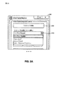
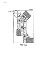
[0027] 図1は、屋内マップのラスタ画像をベクトル画像に変換するプロセス100を例示する。プロセスブロック105において、屋内マップを示すラスタ画像が受信される。1つの実施形態において、ラスタ画像はピクセルのグリッドを表すデータ構造を有するファイルを含む。ラスタ画像ファイルは、限定ではなく、*.bmp、*.jpeg、*.tiff、*.raw、*.gif、*.png、等を含む、様々なフォーマットでありうる。ラスタ画像は、図2Aのユーザインターフェース200のようなユーザインターフェースによって受信されうる。ユーザインターフェース200は、変換されることになるラスタ画像のファイル名とロケーションをユーザ(図示せず)が入力することを可能にするボタン205を含む。
[0027] FIG. 1 illustrates a
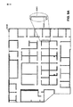
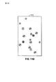
[0028] ラスタ画像が受信されると、マップタイプが分類されうる。ラスタ画像に含まれるマップは様々なタイプでありうる。1つのタイプは、図3のラインマップ300のようなラインマップでありうる。ラインマップ300は、概して、建物構造の様々な特徴を表すラインを含むツートーン(two-tone)画像である。例えば、ラインマップ300は、建物の境界を示すライン305、内壁を示すライン310、および出入口を示すライン315を含む。ラインマップ300は、また、廊下320を例示し、さらに、注釈325のような非建物構造(すなわち、注釈)を含みうる。
[0028] Once the raster image is received, the map type may be classified. The maps included in the raster image can be of various types. One type may be a line map such as the
[0029] 第2のタイプのマップは、図4のカラーブロックマップ400Aおよび400Bのようなカラーブロックマップでありうる。示されるように、カラーブロックマップ400Aおよび400Bは、建物構造の領域を色付きブロックとして示す。例えば、マップ400Aおよび400Bは、(図4において異なる網掛けによって例示されている)色付きブロック402、404、406、408、410、および412を含む。更なる例として、色付きブロックは、異なる色でマップの異なる領域を表す。カラーブロックマップ400Aおよび400Bは、また、注釈414、416、および418を含む。
[0029] The second type of map may be a color block map such as
[0030] 第3のタイプのマップは、図5のハイブリッドマップ500Aおよび500Bのようなハイブリッドマップでありうる。図5に示されるように、ハイブリッドマップ500Aおよび500Bは、(異なる網掛けによって例示されている)アウトライン化されたカラーブロックとして建物構造の領域を示す。例えば、マップ500Aおよび500Bは、色付きブロック502、504、506、および508、ならびにアウトライン512および514を含む。ハイブリッドマップ500Aおよび500Bにさらに含まれるのは、注釈516、518、および520である。
[0030] The third type of map may be a hybrid map such as
[0031] ここで図2Aに戻って参照すると、ユーザインターフェース200は、実例的なプルダウンメニュー210によって、マップタイプを定義するユーザ入力を提供しうる。示されるように、プルダウンメニュー210は、ユーザが3つのマップタイプ、すなわち、ラインマップ、カラーブロック、およびカラーブロック+アウトライン(すなわち、ハイブリッド)、のうちの1つを選択することを可能にする。図1に示されるように、マップタイプが入力された後に、判定ブロック110は、ラインマップタイプが選択されたかどうかを決定する。ラインマップタイプではない場合、プロセス100は、非ラインマップがラインマップに変換されるプロセスブロック115に進む。例えば、カラーブロックマップタイプが選択された場合、カラーブロックマップはラインマップに変換される。同様に、ハイブリッドマップタイプが選択された場合、ハイブリッドマップタイプはラインマップに変換される。
[0031] Referring back to FIG. 2A, the
[0032] 1つの実施形態において、マップタイプの分類は、ユーザ入力に応じてというよりも自動的に行われうる。すなわち、受信されたラスタ画像がラインマップ、カラーブロックマップ、またはハイブリッドマップであるかを自動的に検出するソフトウェアおよび/またはハードウェアがインプリメントされうる。例として、図2Bは、マップタイプを自動的に決定するプロセス212を例示する。プロセス212は、図1の判定ブロック110の1つの可能なインプリメンテーションである。
[0032] In one embodiment, the map type classification may be performed automatically rather than in response to user input. That is, software and / or hardware that automatically detects whether a received raster image is a line map, a color block map, or a hybrid map may be implemented. As an example, FIG. 2B illustrates a
[0033] プロセス212は、受信された屋内マップがラインマップであるかどうかをテストすることによって開始しうる。図3の実例的なラインマップ300からわかるように、前景ピクセル(すなわち、黒)に対する背景ピクセル(すなわち、白)の比率は高い(すなわち、黒のピクセルよりもずっと多くの白のピクセルがある)。1つの色のピクセルのもう1つの色のピクセルに対するこの高い比率は、ラインマップタイプを示すことが多い。よって、プロセス212は、プロセスブロック214において、第1の色のピクセル数を計算することによって開始する。プロセスブロック216は、次いで、第2の色のピクセル数を計算する。判定ブロック218において、第2の色のピクセルに対する第1の色のピクセルの比率は、しきい値数(例えば、ラインマップの特有な特徴と一致するもの)と比較される。その比率がしきい値よりも大きい場合、受信されたマップはラインマップと決定される。大きくない場合、プロセス212は、受信されたマップが他のタイプのものであるかをテストするために進みうる。
[0033] The
[0034] 図4のカラーブロックマップを簡単に参照すると、カラーブロックマップのいかなる定義されたポリゴンでも、ポリゴンにおける1つの色の連結ピクセル(connected pixels)の数は、そのポリゴンのピクセルの総数に大まかに等しいことがわかる。例えば、カラーブロック410によって定義されたポリゴンは、同色のx個の連結した色付きピクセルと、そのポリゴンに含まれるほぼx個の総ピクセルとを含みうる。1つまたは複数のポリゴンの総ピクセルと連結ピクセルの等しい数を有すると、カラーブロックマップタイプを示すことが多い。したがって、プロセスブロック220において開始して、プロセス212は、受信されたラスタ画像の1つまたは複数のポリゴンに含まれる同色の連結ピクセル数を計算することを含む。次に、プロセスブロック222において、(1つまたは複数の)ポリゴンにおけるピクセルの総数が計算される。判定ブロック224において、総ピクセルに対する連結ピクセルの比率が1にほぼ等しい場合、その受信されたマップはカラーブロックマップと決定される。
[0034] Referring briefly to the color block map of FIG. 4, for any defined polygon in the color block map, the number of connected pixels of one color in the polygon is roughly the total number of pixels in that polygon. It is understood that it is equal to. For example, the polygon defined by the
[0035] 受信されたラスタ画像がラインマップではないと決定され、カラーブロックマップではない場合、プロセス212はラスタ画像がハイブリッドタイプのマップであるかをテストすることを含みうる。上述のように、図5のハイブリッドマップ500Aおよび500Bは、アウトライン化された色付きブロックを含む。したがって、ハイブリッドマップは、ラインマップ(すなわち、アウトライン)とカラーブロックマップ(すなわち、色付きブロック)の両方の特性を示しうる。したがって、プロセス212は、受信されたラスタ画像をカラーレイヤ(すなわち、色ごとに1つのレイヤ)に分離するプロセスブロック226を含む。次に、判定ブロック228において、レイヤのうちの少なくとも1つがラインマップであるかどうかと、レイヤのうちの少なくとももう1つがカラーブロックマップであるかどうかとが決定される。そうである場合、受信されたマップはハイブリッドマップであると決定される。レイヤがラインマップであるかカラーブロックマップであるかを決定するために使用されるプロセスは、プロセスブロック214〜224において上述されたものと同様でありうる。また、図2Bは、受信されたラスタ画像がラインマップであるかどうかを最初に決定し、その次にそれがカラーブロックおよびハイブリッドマップであるかどうかをテストするものとして、プロセス212を例示しているが、マップタイプのテストは、本開示の教示と矛盾しない、いかなる順序でも行われることができる。
[0035] If the received raster image is determined not to be a line map and not a color block map, the
[0036] ここで再度図1を参照すると、次にプロセスブロック120において、今ではもうラインマップを含んでいるラスタ画像が処理される。以下でより詳細に開示されることになる実施形態にしたがって、様々な画像処理がラスタ画像に適用されて、プロセスブロック125のベクトル変換のための画像を準備する。プロセスブロック125において、ベクトルラインは、処理されたラスタ画像から抽出される。
[0036] Referring again to FIG. 1, next, at
[0037] 図6は、ラスタ画像マップの処理600を例示する。プロセス600は、図1のプロセスブロック120の1つの可能なインプリメンテーションである。プロセスブロック605において、ラスタ画像は2値(binary)の白黒画像に変換される。1つの例において、2値化のレベルはユーザが選択可能である。例えば、図7のユーザインターフェース700は、ユーザが画像の2値化のレベルを調整することを可能にするスライダーバー725を提供しうる。
FIG. 6 illustrates a raster
[0038] 次に、プロセスブロック610において、非建物構造(すなわち、注釈)が除去される。本発明の実施形態は、ラインマップ中の注釈を識別するための様々な方法を採用しうる。1つの例において、表示されたラインマップ上の除去されることになる領域を識別するユーザ入力が受信される(すなわち、プロセスブロック620)。ユーザインターフェース700は、マップ上に囲まれた領域をユーザが描くことを可能にするボタン710によってこのオプションを提供することができ、ここで、その領域の中のいずれの特徴も画像から除去されることになる。別の例では、注釈の識別が自動的に行われうる。例えば、ラインマップは、建物構造の壁を表すラインを含む。長いラインは、通常、壁である確率がより高いが、より短いラインは、非建物構造を示しうる。したがって、1つの実施形態において、プロセス600は短いラインの識別615を含む。短いラインの識別は、しきい値量よりも少ない長さを有するラスタ画像中のラインを識別することを含みうる。ユーザ入力でも自動的にでも、非建物構造が識別されると、その非建物構造は画像から除去される。例として、ユーザインターフェース700は、ユーザが、識別された非建物構造を除去することを可能にするボタン715を提供しうる。1つの実施形態において、非建物構造の除去は、除去された構造を背景色(例えば、白)で補充すること(refilling)を含みうる。
[0038] Next, at
[0039] 図6のプロセス600を再度参照すると、いくつかのラインマップは、同じ壁の2辺を表す平行なラインを含みうる。よって、プロセスブロック625は、互いにごく接近にしている平行ラインをマージするためのオプションを提供する。図7に示されるように、ユーザインターフェース700は、ユーザがラインマップの処理タイプを選択することを可能にするプルダウンメニュー730を含む。1つの例において、メニュー730は、3つのオプション、すなわち、ラインマージなし、厳密な(strict)ラインマージ、および緩い(relaxed)ラインマージ、を提供しうる。厳密なラインマージは、ラインが互いにごく極めて接近している(例えば、3ピクセル以下)ときにのみ、それらをマージすることを提供しうるが、緩いラインマージは、さらに離れているライン(例えば、5ピクセル以下)をマージすることを可能にしうる。
[0039] Referring back to the
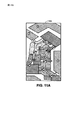
[0040] 図9A〜9Cは、ベクトル変換の前および後のラインマップ上のラインマージの効果を例示する。図9Aは、互いにごく接近しているいくつかの平行ライン904Aおよび906Aを有するラインマップ900Aのラスタ画像を例示する。図9Bは、ラインマージを用いない、図9Aのラスタ画像のベクトル画像への変換を例示する。ベクトルマップ900Bからわかるように、平行ライン904Aおよび906Aは、平行なベクトルライン904Bおよび906Bに変換されている。しかしながら、図9Cは、ラインマージを用いた図9Aのラスタ画像のベクトル画像への変換を例示する。図9Cに示されるように、平行ライン904Aおよび906Aは、単一のベクトルライン908にマージされている。
[0040] FIGS. 9A-9C illustrate the effect of line merging on the line map before and after vector transformation. FIG. 9A illustrates a raster image of a
[0041] ここで図6を再度参照すると、プロセス600は、ラスタ画像のラインを同じ厚さのラインに変換するためのプロセスブロック630をさらに含む。1つの実施形態において、全てのラインが同じ厚さ(例えば、1ピクセル)を有するように厚いラインは薄くされる。
[0041] Referring back to FIG. 6, the
[0042] 図8Aおよび図8Bは、ラスタ画像800からベクトル画像802へのラインマップの変換を例示する。図8Bに示されるように、注釈804は除去されず、ベクトル画像802に留まっている。上述のように、より長いラインは、壁であるより高い確率を表しうるが、より短いラインは注釈を示しうる。したがって、1つの実施形態において、ベクトル画像802のベクトルラインが、それらの長さによってカラーコーディングされうる。例えば、図8Bの実施形態において、ベクトルライン806は、それが比較的長いラインであって壁を示しやすいので、青く色付けされうるのに対して、ベクトルライン808は比較的短いラインであり、出入り口のような非建物構造を表しうるため、赤く色付けされる。したがって、いくつかの実施形態において、より短いラインはより長いライン(例えば、青)とは異なる(例えば、赤)ように色付けされる。例として、ラインの色付けはヒューリスティックス(heuristics)に基づきうる。しかしながら、ユーザが、短いラインが有効な建物構造であると決定した場合、建物構造のリストに短いラインを追加し、次いで、長いラインと同様に色付けされうる。
[0042] FIGS. 8A and 8B illustrate line map conversion from
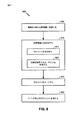
[0043] 図10は、カラーブロックマップおよびハイブリッドマップをラインマップに変換するプロセス1000を例示する。プロセス1000は、図1のプロセスブロック115の1つの可能なインプリメンテーションである。図2のユーザインターフェース200のプルダウンメニュー210からのユーザ入力のような、マップタイプを示すユーザ入力に応答して、判定ブロック1005は、選択されたマップタイプがカラーブロックマップであるかハイブリッドマップであるかを決定する。カラーブロックマップであった場合、プロセス1000はプロセスブロック1010に進む。ハイブリッドマップであった場合、プロセスはプロセスブロック1015に進む。
[0043] FIG. 10 illustrates a
[0044] プロセスブロック1010において、非建物構造は、カラーブロックマップから最初に除去される。本発明の実施形態は、カラーブロックマップ中の注釈を識別するための様々な方法を採用しうる。1つの例において、表示されたラインマップ上の除去されることになる領域を識別するユーザ入力が受信される。ユーザインターフェース700は、マップ上に囲まれた領域をユーザが描くことを可能にする、ボタン710によってこのオプションを提供することができ、ここで、その領域の中のいずれの特徴も画像から除去されることになる。別の例において、カラーブロックマップ中の注釈の識別は、除去されることになる注釈の色を指定するユーザ入力を受信することによって行われうる。ユーザインターフェース700は、ユーザが非建物構造のマップ上での色を選択することを可能にする、ボタン705によってこのオプションを提供しうる。
[0044] At
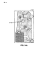
[0045] カラーブロックマップにおける非建物構造を識別するさらに別の方法において、プロセス1000は、色付きブロックに含まれる色に基づいてラスタ画像におけるカラーセグメントを作成しうる。図11A、11C、および11Dにおいて、色付き領域は、その図の網掛け領域によって例示されている。図11Aの例示された例において、1つのセグメントが1つの色の注釈のために作成されるが、別のセグメントが、その注釈の周囲の色付きブロックのために作成される。次いで、各カラーセグメントが非建物構造であるかどうかが決定される。1つの例において、より小さいカラーセグメントが、注釈である確率がより高いが、より大きいカラーセグメントは、建物構造をより表しやすい。したがって、プロセス1000は、しきい値量よりも小さいカラーセグメントを非建物構造として識別しうる。図11Aのカラーブロックマップ1105の検出された注釈は、注釈1110として図11Bに示される。次に、図11Cに示されるように、非建物構造として識別されたカラーセグメントが、次いで、画像から除去され、背景色(例えば、白)で補充される。図11Dに示されるように、小さく囲われたエリアは、次いで、それらのそれぞれの周囲の色で再び色付けされる。図11Eは、ラインマップに変換するためのエッジ検出とその次のベクトルラインの抽出との後の結果となるベクトル画像1125を例示する。1つの実施形態において、図10のプロセス1000は、ガウシアンフィルタのラプラシアン(Laplacian of Gaussian filter)によって、エッジ検出1020を実行する。
[0045] In yet another method of identifying non-building structures in a color block map,
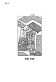
[0046] カラーブロックマップと同様に、本発明の実施形態は、ハイブリッドマップ中の注釈を識別するための様々な類似した方法を採用しうる。例えば、除去されることになる非建物構造の色または領域を指定するユーザ入力が受信されうる。さらに、カラーセグメントが作成され、ここで、小さいセグメントがラスタ画像から除去され、背景色で補充される。図12Aは、その図において色付き領域が網掛け領域として示され、ベクトルマップに変換されることになるハイブリッドマップ1205を例示する。セグメント化されたマップ1205は、色に基づいて異なるレイヤに最初に分離され、ここで、1つのレイヤは色ごとである。次いで、建物構造を表すための実質的に大きい連結コンポーネントをレイヤが有するかに少なくとも部分的に基づいて、レイヤがエッジ検出のために選択される。例えば、図12Bは、注釈レイヤが識別され、除去され、背景色(例えば、白)で補充された後のマップを例示する。図12Bにおいて、その図の色付き領域は、網掛け領域を使用して例示される。図12Cは、エッジ検出とベクトルラインの抽出の後の結果となるベクトル画像1215を例示する。
[0046] As with color block maps, embodiments of the present invention may employ a variety of similar methods for identifying annotations in hybrid maps. For example, user input may be received that specifies the color or area of the non-building structure that is to be removed. In addition, color segments are created, where small segments are removed from the raster image and replenished with the background color. FIG. 12A illustrates a
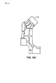
[0047] 図13は、図12Aのハイブリッドマップをレイヤにするプロセスを例示し、ここで、その図の異なる色付き領域が異なる網掛けを使用して例示される。示されるように、ハイブリッドマップ1305のレイヤを作成することは、いくつかのレイヤ1310〜1335が作成されるという結果となる。上述のように、各レイヤは、ハイブリッドマップ1305の1つの色を表しうる。大きな連結構造を有するレイヤは、エッジ検出のためのレイヤとして識別されうるが、他のレイヤは、注釈レイヤとして識別されうるか、または破棄するためのレイヤとさえも識別されうる。例えば、レイヤ1310および1315は、エッジレイヤとして識別されうるが、レイヤ1320は注釈レイヤとして識別される。さらに、レイヤ1330、1325、および1335は、「他のレイヤ」として識別され、破棄されうる(すなわち、エッジ検出に使用されない)。
[0047] FIG. 13 illustrates the process of layering the hybrid map of FIG. 12A, where the different colored regions of the figure are illustrated using different shading. As shown, creating the layers of the
[0048] 図14A〜14Bは、色1410Aのユーザ選択による注釈除去のプロセスを例示するが、図15A〜15Bは、領域1510Aのユーザ選択による注釈除去のプロセスを例示する。図14A〜図14Bおよび図15A〜図15Bにおいて、異なる色付き領域が異なる網掛けを使用して例示される。
[0048] FIGS. 14A-14B illustrate the process of annotation removal by user selection of
[0049] 図16は、ナビゲーションシステム1600の機能ブロック図である。示されるように、ナビゲーションシステム1600は、マップサーバ1605、ネットワーク1610、マップソース1615、およびモバイルデバイス1620を含みうる。マップソース1615はメモリを備え、ラスタフォーマットまたはベクトルフォーマットでありうる電子マップを記憶しうる。電子マップは、建物構造の様々な内部特徴を示しうるラインセグメントの図面を含みうる。
FIG. 16 is a functional block diagram of the
[0050] 1つのインプリメンテーションにおいて、マップソース1615は、建物についての紙のブループリント(青写真、青焼きpaper blueprints)を、正しく縮尺されていない電子フォーマットにスキャンすることによって、電子マップを作成しうる。代替的に、マップソース1615は、例えば、建物を設計した建築会社、または公的記録から、電子マップを獲得しうる。
[0050] In one implementation, the
[0051] 電子マップ1625は、マップソース1615によって、ネットワーク1610を介してマップサーバ1605に送信されうる。マップソース1615は、例えば、データベースまたはサーバを備えうる。1つのインプリメンテーションにおいて、マップサーバ1605は、特定のベーシックな電子マップを求める要求をマップソース1615に送信し、それに応じて、その特定の電子マップがマップサーバ1605に送信されうる。マップソース1615内の1つまたは複数のマップはブループリントまたは他の文書からスキャンされうる。
[0051] The
[0052] マップサーバ1605は、ラスタ画像マップをベクトル画像マップに変換するために、ユーザにユーザインターフェースを提供しうる。
[0052] The
[0053] 電子ベクトル画像マップは、その後、マップ上に描写された開始ロケーションから、オフィス、ショッピングモール、スタジアム、または他の屋内環境内の目的ロケーションまで人をガイドするための命令または経路案内を提供するために使用されうる様々な位置支援データを生成するために、ナビゲーションシステムによって利用されうる。人は、1つまたは複数の廊下を通ってガイドされて目的ロケーションに到達しうる。電子マップおよび/または経路案内1630は、ユーザのモバイル局1620に送信されうる。例えば、そのような電子マップおよび/または経路案内は、モバイル局1620のディスプレイスクリーン上に提示されうる。経路案内は、また、モバイル局1620のスピーカーを介して、またはモバイルデバイス1620と通信して、可聴的にユーザに提示されうる。マップサーバ1605、マップソース1615、およびモバイルデバイス1620は、別々のデバイスでありうるか、または、様々な組み合わせで組み合わされうる(例えば、すべてがモバイルデバイス1620に組み込まれ、マップソース1615がマップサーバ1605に組み込まれる、等)。
[0053] The electronic vector image map then provides instructions or route guidance to guide a person from the starting location depicted on the map to a destination location in the office, shopping mall, stadium, or other indoor environment Can be utilized by the navigation system to generate various location assistance data that can be used to A person may be guided through one or more hallways to reach a destination location. The electronic map and / or route guidance 1630 may be transmitted to the user's
[0054] 図17は、本発明の実施形態が実現されうるシステムを例示するブロック図である。このシステムは、コンピューティングデバイス1700であることができ、それは、汎用プロセッサ1702、画像プロセッサ1704、グラフィックスエンジン1706、およびメモリ1708を含みうる。デバイス1700は、モバイルデバイス、ワイヤレスデバイス、セルフォン、携帯情報端末、モバイルコンピュータ、タブレット、パーソナルコンピュータ、ラップトップコンピュータ、または処理能力を有するいかなるタイプのデバイスでありうる。デバイス1700は、また、図16のマップサーバ1605の1つの可能なインプリメンテーションでありうる。
[0054] FIG. 17 is a block diagram illustrating a system in which an embodiment of the invention may be implemented. The system can be a
[0055] デバイス1700は、ディスプレイ1712のような、画像を表示するための手段を含むユーザインターフェース1710を含みうる。ユーザインターフェース1710は、キーボード1714、またはユーザ入力1716がデバイス1700に入力されることができる他の入力デバイスもまた含みうる。必要に応じて、キーボード1714は、仮想キーパッドをタッチセンサ付きのディスプレイ1712に統合することによって不要にされうる。
[0055] The
[0056] メモリ1708は、本明細書に説明されている1つまたは複数のプロセス、インプリメンテーション、または例を行うように実行可能であるコンピュータ可読命令を記憶するように適応されうる。プロセッサ1702は、そのようなマシン可読命令にアクセスし、それら命令を実行するように適応されうる。これらのコンピュータ可読命令の実行を通して、プロセッサ1702は、デバイス1700の様々なエレメントに1つまたは複数の機能を行うように指示しうる。
[0056] The
[0057] メモリ1708は、また、上述のように、分析されラスタ画像からベクトル画像に変換されることになる電子マップを記憶しうる。デバイス1700のハードウェアに含まれるネットワークアダプタは、1つまたは複数の電子マップを、ユーザのモバイルデバイスのような別のデバイスに送信しうる。そのような電子マップを受信したら、ユーザのモバイルデバイスはディスプレイデバイスを介して、更新された電子マップを提示しうる。ネットワークアダプタは、また、分析のための1つまたは複数の電子マップを電子マップソースから受信しうる。
[0057] The
[0058] プロセスブロックのうちのいくつかまたはすべてが各プロセスに現れる順序は、限定的と思われるべきではない。むしろ、本開示の恩恵を有する当業者は、プロセスブロックのいくつかが、例示されていない様々な順序で実行されうることを理解するであろう。 [0058] The order in which some or all of the process blocks appear in each process should not be considered limiting. Rather, one of ordinary skill in the art having the benefit of this disclosure will appreciate that some of the process blocks may be performed in various orders not illustrated.
[0059] 本明細書での教示は、様々な装置(例えば、デバイス)に組み込まれうる(例えば、それらの中にインプリメントされうるか、またはそれらによって実行されうる)。例えば、本明細書に教示されている1つまたは複数の態様は、モバイル局、電話(例えば、セルラ電話)、携帯情報端末(「PDA」)、タブレット、モバイルコンピュータ、ラップトップコンピュータ、タブレット、エンターテイメントデバイス(例えば、音楽またはビデオデバイス)、ヘッドセット(例えば、ヘッドホン、イヤピース、等)、メディカルデバイス(例えば、生体センサ、心拍数モニタ、歩数計、EKGデバイス、等)、ユーザI/Oデバイス、コンピュータ、サーバ、店頭のデバイス、エンターテイメントデバイス、セットトップボックス、または他の任意の適したデバイスに組み込まれうる。これらのデバイスは、異なる電力およびデータ要件を有し、特徴または特徴のセットごとに生成される異なる電力プロファイルを結果としてもたらしうる。 [0059] The teachings herein may be incorporated into (eg, implemented in or performed by) various apparatus (eg, devices). For example, one or more aspects taught herein include mobile stations, telephones (eg, cellular phones), personal digital assistants (“PDAs”), tablets, mobile computers, laptop computers, tablets, entertainment Devices (eg, music or video devices), headsets (eg, headphones, earpieces, etc.), medical devices (eg, biosensors, heart rate monitors, pedometers, EKG devices, etc.), user I / O devices, computers , Servers, point-of-sale devices, entertainment devices, set-top boxes, or any other suitable device. These devices have different power and data requirements and may result in different power profiles generated for each feature or set of features.
[0060] 本明細書で使用されているように、移動局(MS)は、セルラまたは他のワイヤレス通信デバイス、パーソナル通信システム(PCS)デバイス、パーソナルナビゲーションデバイス(PND)、個人情報管理(PIM)、携帯情報端末(PDA)、ラップトップ、タブレット、またはワイヤレス通信および/またはナビゲーション信号を受信することが可能である他の適したモバイルデバイス、のようなデバイスを指す。「モバイル局」という用語は、また、衛星信号の受信、支援データの受信、および/または位置関連の処理がデバイスまたはパーソナルナビゲーションデバイス(PND)において生じるかにかかわらず、例えば、短距離ワイヤレス接続、赤外線接続、有線接続、または他の接続によって、PNDと通信するデバイスを含むように意図される。また、「移動局」は、衛星信号の受信、支援データの受信、および/または位置関連の処理が、デバイス、サーバ、またはネットワークと関連した別のデバイスにおいて生じるかにかかわらず、例えば、インターネット、WiFi(登録商標)、または他のネットワークを介して、サーバと通信することが可能である、ワイヤレス通信デバイス、コンピュータ、ラップトップ、等を含む、全てのデバイスを含むように意図される。上記の任意の動作可能な組み合わせは、「モバイル局」とも見なされる。 [0060] As used herein, a mobile station (MS) is a cellular or other wireless communication device, a personal communication system (PCS) device, a personal navigation device (PND), a personal information management (PIM). , Devices such as personal digital assistants (PDAs), laptops, tablets, or other suitable mobile devices capable of receiving wireless communication and / or navigation signals. The term “mobile station” also refers to, for example, a short-range wireless connection, regardless of whether satellite signal reception, assistance data reception, and / or position-related processing occurs at the device or personal navigation device (PND). It is intended to include devices that communicate with the PND by infrared connection, wired connection, or other connection. Also, a “mobile station” may be, for example, the Internet, whether satellite signal reception, assistance data reception, and / or location-related processing occurs at a device, server, or another device associated with a network. It is intended to include all devices, including wireless communication devices, computers, laptops, etc., capable of communicating with a server via WiFi® or other networks. Any operable combination of the above is also considered a “mobile station”.
[0061] いくつかの態様において、ワイヤレスデバイスは、通信システムのためのアクセスデバイス(例えば、Wi−Fi(登録商標)アクセスポイント)を備えうる。そのようなアクセスデバイスは、例えば、有線またはワイヤレス通信リンクを介した、別のネットワーク(例えば、インターネットまたはセルラネットワークのような広域ネットワーク)への接続を提供しうる。したがって、アクセスデバイスは、別のデバイス(例えば、Wi−Fi局)が他方のネットワークまたは他の何らかの機能にアクセスすることを可能する。さらに、デバイスの一方または両方が、携帯可能でありうるか、または、いくつかの場合において、比較的に携帯可能でないことが認識されるべきである。 [0061] In some aspects, the wireless device may comprise an access device (eg, a Wi-Fi® access point) for the communication system. Such an access device may provide a connection to another network (eg, a wide area network such as the Internet or a cellular network), for example, via a wired or wireless communication link. Thus, the access device allows another device (eg, a Wi-Fi station) to access the other network or some other function. Furthermore, it should be appreciated that one or both of the devices may be portable or, in some cases, relatively unportable.
[0062] 当業者は、情報および信号が、様々な異なる技術および技法のいずれかを使用して表されうることを理解するであろう。例えば、上記の説明全体を通して参照されうる、データ、命令、コマンド、情報、信号、ビット、シンボル、およびチップは、電圧、電流、電磁波、磁界あるいは磁気粒子、光場または光粒子、あるいはそれらの任意の組み合わせによって表されうる。 [0062] Those skilled in the art will appreciate that information and signals may be represented using any of a variety of different technologies and techniques. For example, data, instructions, commands, information, signals, bits, symbols, and chips that can be referred to throughout the above description are voltages, currents, electromagnetic waves, magnetic fields or magnetic particles, light fields or light particles, or any of them. Can be represented by a combination of
[0063] 当業者はさらに、本明細書に開示された実施形態と関連して説明されている様々な例示的な論理ブロック、モジュール、エンジン、回路、およびアルゴリズムステップが電子ハードウェア、コンピュータソフトウェア、または両方の組み合わせとしてインプリメントされうることをさらに認識するであろう。このハードウェアおよびソフトウェアの互換性を明確に例示するために、様々な例示的なコンポーネント、ブロック、モジュール、エンジン、回路、およびステップが、それらの機能性の点から上で概して説明されている。このような機能性が、ハードウェアとしてインプリメントされるかソフトウェアとしてインプリメントされるかは、システム全体に課せられた特定のアプリケーションおよび設計制約に依存する。当業者は、説明された機能性を特定のアプリケーションごとに多様な方法でインプリメントすることができるが、このようなインプリメンテーションの判断は本発明の範囲からの逸脱の引き起こすものとして解釈されるべきではない。 [0063] Those skilled in the art further understand that the various exemplary logic blocks, modules, engines, circuits, and algorithm steps described in connection with the embodiments disclosed herein are electronic hardware, computer software, It will be further appreciated that or may be implemented as a combination of both. To clearly illustrate this hardware and software compatibility, various illustrative components, blocks, modules, engines, circuits, and steps have been described above generally in terms of their functionality. Whether such functionality is implemented as hardware or software depends upon the particular application and design constraints imposed on the overall system. Those skilled in the art can implement the described functionality in a variety of ways for a particular application, but such implementation decisions should be construed as causing deviations from the scope of the present invention. is not.
[0064] 本明細書に開示された実施形態と関連して説明されている様々な例示的な論理ブロック、モジュール、および回路は、汎用プロセッサ、デジタル信号プロセッサ(DSP)、特定用途向け集積回路(ASIC)、フィールドプログラム可能ゲートアレイ(FPGA)、または他のプログラム可能論理デバイス、ディスクリートゲートまたはトランジスタ論理、ディスクリートハードウェアコンポーネント、あるいは、本明細書に説明された機能を実行するように設計されたこれらの任意の組み合わせを用いて実行またはインプリメントされうる。汎用プロセッサはマイクロプロセッサでありうるが、代替的に、このプロセッサは、任意の従来のプロセッサ、コントローラ、マイクロコントローラ、またはステートマシンでありうる。プロセッサは、また、例えば、DSPとマクロプロセッサの組み合わせ、複数のマイクロプロセッサ、DSPコアに連結した1つまたは複数のマイクロプロセッサ、または任意の他のそのような構成といった、コンピューティングデバイスの組み合わせとしてインプリメントされうる。 [0064] Various exemplary logic blocks, modules, and circuits described in connection with the embodiments disclosed herein include general purpose processors, digital signal processors (DSPs), application specific integrated circuits ( ASIC), field programmable gate array (FPGA), or other programmable logic device, discrete gate or transistor logic, discrete hardware components, or these designed to perform the functions described herein Can be implemented or implemented using any combination of A general purpose processor may be a microprocessor, but in the alternative, the processor may be any conventional processor, controller, microcontroller, or state machine. A processor may also be implemented as a combination of computing devices such as, for example, a combination of a DSP and a macro processor, a plurality of microprocessors, one or more microprocessors coupled to a DSP core, or any other such configuration. Can be done.
[0065] 本明細書に開示された実施形態に関連して説明されている方法またはアルゴリズムのステップは、直接ハードウェアにおいて、プロセッサによって実行されるソフトウェアモジュールにおいて、またはこれら2つの組み合わせにおいて、具現化されうる。ソフトウェアモジュールは、RAMメモリ、フラッシュメモリ、ROMメモリ、EPROMメモリ、EEPROM(登録商標)メモリ、レジスタ、ハードディスク、リムーバルディスク、CD−ROM、または当該技術分野で既知の他の任意の形態の記憶媒体内に存在しうる。実例的な記憶媒体は、プロセッサが記憶媒体から情報を読み取り、記憶媒体に情報を書き込むことができるように、プロセッサに結合されうる。代替的に、記憶媒体は、プロセッサに一体化されうる。プロセッサおよび記憶媒体は、ASIC内に存在しうる。ASICは、ユーザ端末内に存在しうる。代替的に、プロセッサおよび記憶媒体は、ユーザ端末内にディスクリートコンポーネントとして存在しうる。 [0065] Method or algorithm steps described in connection with the embodiments disclosed herein may be implemented directly in hardware, in software modules executed by a processor, or in a combination of the two. Can be done. The software module may be in RAM memory, flash memory, ROM memory, EPROM memory, EEPROM® memory, registers, hard disk, removable disk, CD-ROM, or any other form of storage medium known in the art. Can exist. An illustrative storage medium may be coupled to the processor such that the processor can read information from, and write information to, the storage medium. In the alternative, the storage medium may be integral to the processor. The processor and the storage medium may reside in an ASIC. The ASIC may exist in the user terminal. In the alternative, the processor and the storage medium may reside as discrete components in a user terminal.
[0066] 1つまたは複数の実例的な実施形態において、説明された機能は、ハードウェア、ソフトウェア、ファームウェア、またはこれらの任意の組み合わせにインプリメントされうる。コンピュータプログラム製品としてソフトウェアにインプリメントされる場合、これら機能は、非一時的なコンピュータ可読媒体上に、1つまたは複数の命令またはコードとして記憶または送信されうる。コンピュータ可読媒体は、ある場所から別の場所へのコンピュータプログラムの転送を容易にする任意の媒体を含む通信媒体とコンピュータ記憶媒体の両方を含むことができる。記憶媒体は、コンピュータによってアクセスされることができる任意の利用可能な媒体でありうる。限定ではなく例として、そのような非一時的なコンピュータ可読媒体は、RAM、ROM、EEPROM、CD−ROMあるいは他の光ディスク記憶装置、磁気ディスク記憶装置あるいは他の磁気記憶デバイス、または、命令あるいはデータ構造の形態で所望のプログラムコードを記憶または搬送するために使用されることができ、およびコンピュータによってアクセスされることができる、任意の他の媒体を備えることができる。また、任意の接続は、コンピュータ可読媒体と厳密には称される。例えば、ソフトウェアがウェブサイト、サーバ、または他の遠隔ソースから、同軸ケーブル、光ファイバーケーブル、ツイストペア、デジタル加入者回線(DSL)、あるいは赤外線、無線、およびマイクロ波のようなワイヤレス技術を使用して送信される場合、同軸ケーブル、光ファイバーケーブル、ツイストペア、DSL、あるいは赤外線、無線、およびマイクロ波のようなワイヤレス技術は媒体の定義に含まれる。本明細書に使用される、ディスク(disk)およびディスク(disc)は、コンパクトディスク(CD)、レーザーディスク(登録商標)、光ディスク、デジタル多用途ディスク(DVD)、フロッピー(登録商標)ディスク、およびブルーレイディスクを含み、ディスク(disk)は通常、磁気的にデータを再生するが、ディスク(disc)は、レーザーを用いて光学的にデータを再生する。上記の組み合わせは、また、非一時的なコンピュータ可読媒体の範囲内に含まれるべきである。 [0066] In one or more illustrative embodiments, the functions described may be implemented in hardware, software, firmware, or any combination thereof. When implemented in software as a computer program product, these functions may be stored or transmitted as one or more instructions or code on a non-transitory computer readable medium. Computer-readable media can include both communication media and computer storage media including any medium that facilitates transfer of a computer program from one place to another. A storage media may be any available media that can be accessed by a computer. By way of example, and not limitation, such non-transitory computer readable media is RAM, ROM, EEPROM, CD-ROM or other optical disk storage device, magnetic disk storage device or other magnetic storage device, or instructions or data. Any other medium that can be used to store or carry the desired program code in the form of a structure and that can be accessed by a computer can be provided. Any connection is also strictly referred to as a computer-readable medium. For example, software transmits from a website, server, or other remote source using coaxial cable, fiber optic cable, twisted pair, digital subscriber line (DSL), or wireless technologies such as infrared, wireless, and microwave Where possible, coaxial cable, fiber optic cable, twisted pair, DSL, or wireless technologies such as infrared, radio, and microwave are included in the definition of media. As used herein, disks and discs include compact discs (CD), laser discs, optical discs, digital versatile discs (DVDs), floppy discs, and Including Blu-ray discs, disks typically reproduce data magnetically, while discs optically reproduce data using a laser. Combinations of the above should also be included within the scope of non-transitory computer readable media.
[0067] 開示された実施形態の先の説明は、様々な色、カラーブロック、色付きのライン、等を指す。本開示に添付の図面が、様々な色、カラーブロック、および色付きのラインを表すために、様々なハッチングおよびクロスハッチングを含むことに留意されたい。 [0067] The previous description of the disclosed embodiments refers to various colors, color blocks, colored lines, and the like. It should be noted that the drawings accompanying this disclosure include various hatches and cross-hatches to represent various colors, color blocks, and colored lines.
[0068] 本明細書に開示された実施形態に対する様々な修正は、当業者には容易に明らかであり、本明細書において定義された包括的な原理は、本発明の範囲または精神から逸脱することなく他の実施形態に適用されうる。したがって、本発明は、本明細書に示された実施形態に限定されるように意図されておらず、本明細書に開示されている原理および新規な特徴と一致する最も広い範囲を与えられるべきである。 [0068] Various modifications to the embodiments disclosed herein will be readily apparent to those skilled in the art, and the generic principles defined herein depart from the scope or spirit of the invention. It can be applied to other embodiments without. Accordingly, the present invention is not intended to be limited to the embodiments shown herein, but is to be accorded the widest scope consistent with the principles and novel features disclosed herein. It is.
[0068] 本明細書に開示された実施形態に対する様々な修正は、当業者には容易に明らかであり、本明細書において定義された包括的な原理は、本発明の範囲または精神から逸脱することなく他の実施形態に適用されうる。したがって、本発明は、本明細書に示された実施形態に限定されるように意図されておらず、本明細書に開示されている原理および新規な特徴と一致する最も広い範囲を与えられるべきである。
以下に、本願出願の当初の特許請求の範囲に記載された発明を付記する。
[C1]
ラスタ画像マップをベクトル画像マップに変換するための、コンピュータによってインプリメントされる方法であって、
建物構造の屋内マップを示す電子ラスタ画像を受信することと、
前記屋内マップがラインマップであるかを決定することと、そうでない場合に、前記屋内マップをラインマップに変換することと、ここで、前記ラインマップは前記建物構造の特徴を表すラインを含み、
前記屋内マップの処理されたラスタ画像を生成するために、前記電子ラスタ画像を処理することと、
前記建物構造の前記屋内マップを示す電子ベクトル画像を生成するために、前記処理されたラスタ画像からベクトルラインを抽出することと、
を備える、方法。
[C2]
前記屋内マップがラインマップであるかを決定することは、第1の色のピクセルの第2の色のピクセルに対する比率がしきい値より上であるかを決定することを含む、C1に記載の方法。
[C3]
前記電子ラスタ画像を処理することは、
前記屋内マップから非建物構造を除去することと、
平行であり互いにごく接近しているラインをマージすることと、
前記ラインマップのラインを同じ厚さのラインに変換することと、
のうちの少なくとも1つを含む、C1に記載の方法。
[C4]
前記非建物構造は、長さを有する第1のラインを含み、前記方法はさらに、前記第1のラインの長さがしきい値量よりも少ない場合に前記第1のラインを非建物構造として自動的に識別することと、識別された前記非建物構造を前記屋内マップから自動的に除去することと、を備える、C3に記載の方法。
[C5]
前記屋内マップから非建物構造を除去することは、非建物構造である前記屋内マップの領域を指定するユーザ入力を受信することを含む、C3に記載の方法。
[C6]
前記屋内マップがカラーブロックマップであるかを決定することをさらに備え、ここで、前記カラーブロックマップは前記建物構造の領域を色付きブロックとして示し、前記屋内マップがカラーブロックマップであるかを決定することは、ポリゴンのピクセルの総数に対する前記ポリゴンに含まれる第1の色の連結ピクセルの比率が1にほぼ等しいかを決定することを含む、C1に記載の方法。
[C7]
前記屋内マップをラインマップに変換することは、カラーブロックマップをラインマップに変換することを含み、前記方法は、
前記屋内マップから非建物構造を除去することと、
前記ラインマップを生成するために、前記カラーブロックマップのエッジを検出することと、
を備える、C1に記載の方法。
[C8]
前記屋内マップから非建物構造を除去することは、
前記カラーブロックマップの色付きブロックに含まれる色に基づいて、前記ラスタ画像における1つまたは複数のカラーセグメントを作成することと、
前記1つまたは複数のカラーセグメントの各々が非建物構造であるかを決定することと、
非建物構造と識別された任意のカラーセグメントを除去することと、
除去された前記カラーセグメントを背景色で補充することと、
を備える、C7に記載の方法。
[C9]
前記1つまたは複数のカラーセグメントの各々が非建物構造であるかを決定することは、非建物構造である前記カラーセグメントの色を指定するユーザ入力を受信することを含む、C8に記載の方法。
[C10]
カラーセグメントが非建物構造であるかを決定することは、前記カラーセグメントを含む領域を指定するユーザ入力を受信することを含む、C8に記載の方法。
[C11]
カラーセグメントが非建物構造であるかを決定することは、前記カラーセグメントのサイズがしきい値量よりも少ないかを決定することを含む、C8に記載の方法。
[C12]
前記カラーブロックマップのエッジを検出することは、前記ラインマップのためのラインを抽出するために、ガウシアンフィルタのラプラシアンを前記カラーブロックマップに適用することを含む、C7に記載の方法。
[C13]
前記屋内マップがハイブリッドマップであるかを決定することをさらに備え、前記屋内マップがハイブリッドマップであるかを決定することは、前記屋内マップをカラーレイヤに分離することと、第1のカラーレイヤがラインマップであるか、および第2のレイヤがカラーブロックマップであるかを決定することとを含む、C1に記載の方法。
[C14]
前記屋内マップをラインマップに変換することは、ハイブリッドマップをラインマップに変換することを含み、前記方法は、
前記ハイブリッドマップにおける色ごとのレイヤを作成することと、
前記建物構造を表すために実質的に大きい連結コンポーネントを有する少なくとも1つのレイヤを選択することと、
前記ラインマップを生成するために、選択された各レイヤのエッジを検出することと、
を備える、C13に記載の方法。
[C15]
選択された各レイヤのエッジを検出することは、前記ラインマップのためのラインを抽出するために、ガウシアンフィルタのラプラシアンを選択された前記レイヤに適用することを含む、C14に記載の方法。
[C16]
ラスタ画像マップをベクトル画像マップに変換するためのプログラムコードを記憶したコンピュータ可読媒体であって、前記プログラムコードは、
建物構造の屋内マップを示す電子ラスタ画像を受信し、
前記屋内マップがラインマップであるかを決定し、そうでない場合に、前記屋内マップをラインマップに変換し、ここで、前記ラインマップは前記建物構造の特徴を表すラインを含み、
前記屋内マップの処理されたラスタ画像を生成するために、前記電子ラスタ画像を処理し、
前記建物構造の前記屋内マップを示す電子ベクトル画像を生成するために前記処理されたラスタ画像からベクトルラインを抽出する
ための命令を備える、コンピュータ可読媒体。
[C17]
前記屋内マップがラインマップであるかを決定するための命令は、第1の色のピクセルの第2の色のピクセルに対する比率がしきい値より上であるかを決定するための命令を含む、C16に記載のコンピュータ可読媒体。
[C18]
前記電子ラスタ画像を処理するための命令は、
前記屋内マップから非建物構造を除去し、
平行であり互いにごく接近しているラインをマージし、
前記ラインマップのラインを同じ厚さのラインに変換する
ための命令のうちの少なくとも1つを含む、C16に記載のコンピュータ可読媒体。
[C19]
前記屋内マップがカラーブロックマップであるかを決定するための命令をさらに備え、ここで、前記カラーブロックマップは前記建物構造の領域を色付きブロックとして示し、前記屋内マップがカラーブロックマップであるかを決定するための命令は、ポリゴンのピクセルの総数に対する前記ポリゴンに含まれる第1の色の連結ピクセルの比率が1にほぼ等しいかを決定するための命令を含む、C16に記載のコンピュータ可読媒体。
[C20]
前記屋内マップをラインマップに変換するための命令は、カラーブロックマップをラインマップに変換するための命令を含み、前記プログラムコードはさらに、
前記屋内マップから非建物構造を除去し、
前記ラインマップを生成するために前記カラーブロックマップのエッジを検出する
ための命令を備える、C16に記載のコンピュータ可読媒体。
[C21]
前記屋内マップから非建物構造を除去するための命令は、
前記カラーブロックマップの色付きブロックに含まれる色に基づいて、前記ラスタ画像における1つまたは複数のカラーセグメントを作成し、
前記1つまたは複数のカラーセグメントの各々が非建物構造であるかを決定し、
非建物構造と識別された任意のカラーセグメントを除去し、
除去された前記カラーセグメントを背景色で補充する
ための命令を備える、C20に記載のコンピュータ可読媒体。
[C22]
前記1つまたは複数のカラーセグメントの各々が非建物構造であるかを決定するための命令は、非建物構造である前記カラーセグメントの色を指定するユーザ入力を受信するための命令を含む、C21に記載のコンピュータ可読媒体。
[C23]
カラーセグメントが非建物構造であるかを決定するための命令は、前記カラーセグメントのサイズがしきい値量よりも少ないかを決定するための命令を含む、C21に記載のコンピュータ可読媒体。
[C24]
前記屋内マップがハイブリッドマップであるかを決定するための命令をさらに備え、前記屋内マップがハイブリッドマップであるかを決定するための命令は、前記屋内マップをカラーレイヤに分離し、第1のカラーレイヤがラインマップであるか、および第2のレイヤがカラーブロックマップであるかを決定するための命令を含む、C16に記載のコンピュータ可読媒体。
[C25]
前記屋内マップをラインマップに変換するための命令は、ハイブリッドマップをラインマップに変換するための命令を含み、前記プログラムコードはさらに、
前記ハイブリッドマップにおける色ごとのレイヤを作成し、
前記建物構造を表すために実質的に大きい連結コンポーネントを有する少なくとも1つのレイヤを選択し、
前記ラインマップを生成するために、選択された各レイヤのエッジを検出する
ための命令を備える、C24に記載のコンピュータ可読媒体。
[C26]
マップサーバであって、
ラスタ画像マップをベクトル画像マップに変換するためのプログラムコードを記憶するように適応されたメモリと、
前記プログラムコードに含まれる命令にアクセスし、前記命令を実行するように適応された処理ユニットと、を備え、
前記命令が前記処理ユニットによって実行されると、前記処理ユニットは、
建物構造の屋内マップを示す電子ラスタ画像を受信し、
前記屋内マップがラインマップであるかを決定し、そうでない場合に、前記屋内マップをラインマップに変換し、ここで、前記ラインマップは前記建物構造の特徴を表すラインを含み、
前記屋内マップの処理されたラスタ画像を生成するために、前記電子ラスタ画像を処理し、
前記建物構造の前記屋内マップを示す電子ベクトル画像を生成するために前記処理されたラスタ画像からベクトルラインを抽出する
ように前記マップサーバに指示する、マップサーバ。
[C27]
前記屋内マップがラインマップであるかを決定するための命令は、第1の色のピクセルの第2の色のピクセルに対する比率がしきい値より上であるかを決定するための命令を含む、C26に記載のマップサーバ。
[C28]
前記電子ラスタ画像を処理するための命令は、
前記屋内マップから非建物構造を除去し、
平行であり互いにごく接近しているラインをマージし、
前記ラインマップのラインを同じ厚さのラインに変換する
ための命令のうちの少なくとも1つを含む、C26に記載のマップサーバ。
[C29]
前記プログラムコードは、前記屋内マップがカラーブロックマップであるかを決定するように前記マップサーバに指示するための命令をさらに含み、ここで、前記カラーブロックマップは前記建物構造の領域を色付きブロックとして示し、前記屋内マップがカラーブロックであるかを決定するための命令は、ポリゴンのピクセルの総数に対する前記ポリゴンに含まれる第1の色の連結ピクセルの比率が1にほぼ等しいかを決定するための命令を含む、C26に記載のマップサーバ。
[C30]
前記屋内マップをラインマップに変換するための命令は、カラーブロックマップをラインマップに変換するための命令を含み、前記プログラムコードはさらに、
前記屋内マップから非建物構造を除去し、
前記ラインマップを生成するために前記カラーブロックマップのエッジを検出する
ための命令を備える、C26に記載のコンピュータ可読媒体。
[C31]
前記屋内マップから非建物構造を除去するための命令は、
前記カラーブロックマップの色付きブロックに含まれる色に基づいて、前記ラスタ画像における1つまたは複数のカラーセグメントを作成し、
前記1つまたは複数のカラーセグメントの各々が非建物構造であるかを決定し、
非建物構造と識別された任意のカラーセグメントを除去し、
除去された前記カラーセグメントを背景色で補充する
ための命令を備える、C30に記載のマップサーバ。
[C32]
前記プログラムコードは、前記屋内マップがハイブリッドマップであるかを決定するように前記マップサーバに指示するための命令をさらに備え、前記屋内マップがハイブリッドマップであるかを決定するための命令は、前記屋内マップをカラーレイヤに分離し、第1のカラーレイヤがラインマップであるか、および第2のレイヤがカラーブロックマップであるかを決定するための命令を含む、C26に記載のマップサーバ。
[C33]
前記屋内マップをラインマップに変換するための命令は、ハイブリッドマップをラインマップに変換するための命令を含み、前記プログラムコードはさらに、
前記ハイブリッドマップにおける色ごとのレイヤを作成し、
前記建物構造を表すために実質的に大きい連結コンポーネントを有する少なくとも1つのレイヤを選択し、
前記ラインマップを生成するために、選択された各レイヤのエッジを検出する
ように前記マップサーバに指示するための命令を備える、C32に記載のマップサーバ。
[C34]
ラスタ画像マップをベクトル画像マップに変換するためのシステムあって、
建物構造の屋内マップを示す電子ラスタ画像を受信するための手段と、
前記屋内マップがラインマップであるかを決定し、そうでない場合に、前記屋内マップをラインマップに変換するための手段と、ここで、前記ラインマップは前記建物構造の特徴を表すラインを含み、
前記屋内マップの処理されたラスタ画像を生成するために、前記電子ラスタ画像を処理するための手段と、
前記建物構造の前記屋内マップを示す電子ベクトル画像を生成するために前記処理されたラスタ画像からベクトルラインを抽出するための手段と、
を備える、システム。
[C35]
前記屋内マップがラインマップであるかを決定するための手段は、第1の色のピクセルの第2の色のピクセルに対する比率がしきい値より上であるかを決定するための手段を含む、C34に記載のシステム。
[C36]
前記電子ラスタ画像を処理するための手段は、
前記屋内マップから非建物構造を除去するための手段と、
平行であり互いにごく接近しているラインをマージするための手段と、
前記ラインマップのラインを同じ厚さのラインに変換するための手段と、
のうちの少なくとも1つを含む、C34に記載のシステム。
[C37]
前記屋内マップがカラーブロックマップであるかを決定するための手段をさらに備え、ここで、前記カラーブロックマップは前記建物構造の領域を色付きブロックとして示し、前記屋内マップがカラーブロックマップであるかを決定するための手段は、ポリゴンのピクセルの総数に対する前記ポリゴンに含まれる第1の色の連結ピクセルの比率が1にほぼ等しいかを決定するための手段を含む、C34に記載のシステム。
[C38]
前記屋内マップをラインマップに変換するための手段は、カラーブロックマップをラインマップに変換するための手段を含み、前記システムはさらに、
前記屋内マップから非建物構造を除去するための手段と、
前記ラインマップを生成するために前記カラーブロックマップのエッジを検出するための手段と、
を備える、C34に記載のシステム。
[C39]
前記屋内マップから非建物構造を除去するための手段は、
前記カラーブロックマップの色付きブロックに含まれる色に基づいて、前記ラスタ画像における1つまたは複数のカラーセグメントを作成するための手段と、
前記1つまたは複数のカラーセグメントの各々が非建物構造であるかを決定するための手段と、
非建物構造と識別された任意のカラーセグメントを除去するための手段と、
除去された前記カラーセグメントを背景色で補充するための手段と、
を備える、C38に記載のシステム。
[C40]
前記屋内マップがハイブリッドマップであるかを決定するための手段をさらに備え、前記屋内マップがハイブリッドマップであるかを決定するための手段は、前記屋内マップをカラーレイヤに分離し、第1のカラーレイヤがラインマップであるか、および第2のレイヤがカラーブロックマップであるかを決定するための手段を含む、C34に記載のシステム。
[C41]
前記屋内マップをラインマップに変換するための手段は、ハイブリッドマップをラインマップに変換するための手段を含み、前記システムはさらに、
前記ハイブリッドマップにおける色ごとのレイヤを作成するための手段と、
前記建物構造を表すために実質的に大きい連結コンポーネントを有する少なくとも1つのレイヤを選択するための手段と、
前記ラインマップを生成するために、選択された各レイヤのエッジを検出するための手段と、
を備える、C40に記載のシステム。
[0068] Various modifications to the embodiments disclosed herein will be readily apparent to those skilled in the art, and the generic principles defined herein depart from the scope or spirit of the invention. It can be applied to other embodiments without. Accordingly, the present invention is not intended to be limited to the embodiments shown herein, but is to be accorded the widest scope consistent with the principles and novel features disclosed herein. It is.
Hereinafter, the invention described in the scope of claims of the present application will be appended.
[C1]
A computer-implemented method for converting a raster image map to a vector image map, comprising:
Receiving an electronic raster image showing an indoor map of the building structure;
Determining whether the indoor map is a line map; otherwise, converting the indoor map to a line map, wherein the line map includes lines representing characteristics of the building structure;
Processing the electronic raster image to generate a processed raster image of the indoor map;
Extracting vector lines from the processed raster image to generate an electronic vector image representing the indoor map of the building structure;
A method comprising:
[C2]
Determining whether the indoor map is a line map includes determining whether a ratio of a first color pixel to a second color pixel is above a threshold. Method.
[C3]
Processing the electronic raster image includes
Removing non-building structures from the indoor map;
Merging lines that are parallel and in close proximity to each other;
Converting the lines of the line map into lines of the same thickness;
The method of C1, comprising at least one of the following:
[C4]
The non-building structure includes a first line having a length, and the method further includes automatically making the first line as a non-building structure when the length of the first line is less than a threshold amount. And automatically removing the identified non-building structure from the indoor map.
[C5]
The method of C3, wherein removing the non-building structure from the indoor map includes receiving user input specifying a region of the indoor map that is a non-building structure.
[C6]
Further comprising determining whether the indoor map is a color block map, wherein the color block map indicates regions of the building structure as colored blocks and determines whether the indoor map is a color block map. The method of C1, wherein the method includes determining whether a ratio of connected pixels of the first color included in the polygon to a total number of pixels of the polygon is approximately equal to one.
[C7]
Converting the indoor map to a line map includes converting a color block map to a line map, the method comprising:
Removing non-building structures from the indoor map;
Detecting edges of the color block map to generate the line map;
The method of C1, comprising.
[C8]
Removing non-building structures from the indoor map
Creating one or more color segments in the raster image based on colors contained in colored blocks of the color block map;
Determining whether each of the one or more color segments is a non-building structure;
Removing any color segments identified as non-building structures;
Replenishing the removed color segments with a background color;
A method according to C7, comprising:
[C9]
The method of C8, wherein determining whether each of the one or more color segments is a non-building structure includes receiving user input specifying a color of the color segment that is a non-building structure. .
[C10]
The method of C8, wherein determining whether a color segment is a non-building structure includes receiving user input specifying an area that includes the color segment.
[C11]
The method of C8, wherein determining whether the color segment is a non-building structure includes determining whether the size of the color segment is less than a threshold amount.
[C12]
The method of C7, wherein detecting an edge of the color block map includes applying a Laplacian of a Gaussian filter to the color block map to extract a line for the line map.
[C13]
Determining whether the indoor map is a hybrid map, wherein determining whether the indoor map is a hybrid map includes separating the indoor map into color layers and a first color layer comprising: Determining the line map and determining whether the second layer is a color block map.
[C14]
Converting the indoor map to a line map includes converting a hybrid map to a line map, the method comprising:
Creating a layer for each color in the hybrid map;
Selecting at least one layer having a substantially large connected component to represent the building structure;
Detecting edges of each selected layer to generate the line map;
A method according to C13, comprising:
[C15]
The method of C14, wherein detecting an edge of each selected layer includes applying a Laplacian of a Gaussian filter to the selected layer to extract lines for the line map.
[C16]
A computer readable medium storing program code for converting a raster image map into a vector image map, the program code comprising:
Receive an electronic raster image showing an indoor map of the building structure,
Determining whether the indoor map is a line map; otherwise, converting the indoor map to a line map, wherein the line map includes lines representing features of the building structure;
Processing the electronic raster image to generate a processed raster image of the indoor map;
Extract vector lines from the processed raster image to generate an electronic vector image representing the indoor map of the building structure
A computer-readable medium comprising instructions for.
[C17]
The instructions for determining whether the indoor map is a line map includes instructions for determining whether a ratio of pixels of a first color to pixels of a second color is above a threshold value. The computer-readable medium according to C16.
[C18]
The instructions for processing the electronic raster image are:
Removing non-building structures from the indoor map;
Merge lines that are parallel and very close together,
Convert lines in the line map to lines of the same thickness
The computer-readable medium of C16, comprising at least one of instructions for.
[C19]
Further comprising instructions for determining whether the indoor map is a color block map, wherein the color block map indicates areas of the building structure as colored blocks, and whether the indoor map is a color block map. The computer readable medium of C16, wherein the instructions for determining include instructions for determining whether a ratio of connected pixels of the first color included in the polygon to a total number of pixels of the polygon is approximately equal to one.
[C20]
The instructions for converting the indoor map into a line map include instructions for converting a color block map into a line map, and the program code further includes:
Removing non-building structures from the indoor map;
Detect edges of the color block map to generate the line map
The computer-readable medium of C16, comprising instructions for.
[C21]
The instructions for removing non-building structures from the indoor map are:
Creating one or more color segments in the raster image based on colors contained in colored blocks of the color block map;
Determining whether each of the one or more color segments is a non-building structure;
Remove any color segments identified as non-building structures,
Replenish the removed color segment with the background color
The computer-readable medium of C20, comprising instructions for:
[C22]
The instructions for determining whether each of the one or more color segments is a non-building structure includes instructions for receiving user input specifying a color of the color segment that is a non-building structure, C21 A computer-readable medium according to claim 1.
[C23]
The computer readable medium of C21, wherein the instructions for determining whether a color segment is a non-building structure comprises instructions for determining whether the size of the color segment is less than a threshold amount.
[C24]
Instructions for determining whether the indoor map is a hybrid map further comprises instructions for determining whether the indoor map is a hybrid map, separating the indoor map into color layers, and a first color. The computer-readable medium of C16, comprising instructions for determining whether the layer is a line map and whether the second layer is a color block map.
[C25]
The instructions for converting the indoor map into a line map include instructions for converting a hybrid map into a line map, and the program code further includes:
Create a layer for each color in the hybrid map,
Selecting at least one layer having connected components that are substantially large to represent the building structure;
Detect edges of each selected layer to generate the line map
The computer-readable medium of C24, comprising instructions for.
[C26]
A map server,
A memory adapted to store program code for converting a raster image map to a vector image map;
A processing unit adapted to access and execute instructions contained in the program code,
When the instruction is executed by the processing unit, the processing unit
Receive an electronic raster image showing an indoor map of the building structure,
Determining whether the indoor map is a line map; otherwise, converting the indoor map to a line map, wherein the line map includes lines representing features of the building structure;
Processing the electronic raster image to generate a processed raster image of the indoor map;
Extract vector lines from the processed raster image to generate an electronic vector image representing the indoor map of the building structure
A map server that directs the map server to
[C27]
The instructions for determining whether the indoor map is a line map includes instructions for determining whether a ratio of pixels of a first color to pixels of a second color is above a threshold value. The map server described in C26.
[C28]
The instructions for processing the electronic raster image are:
Removing non-building structures from the indoor map;
Merge lines that are parallel and very close together,
Convert lines in the line map to lines of the same thickness
The map server of C26, comprising at least one of instructions for.
[C29]
The program code further includes instructions for instructing the map server to determine whether the indoor map is a color block map, wherein the color block map includes an area of the building structure as a colored block. And the instruction for determining whether the indoor map is a color block is for determining whether a ratio of connected pixels of the first color included in the polygon to a total number of pixels of the polygon is approximately equal to 1. The map server according to C26, comprising instructions.
[C30]
The instructions for converting the indoor map into a line map include instructions for converting a color block map into a line map, and the program code further includes:
Removing non-building structures from the indoor map;
Detect edges of the color block map to generate the line map
The computer-readable medium of C26, comprising instructions for:
[C31]
The instructions for removing non-building structures from the indoor map are:
Creating one or more color segments in the raster image based on colors contained in colored blocks of the color block map;
Determining whether each of the one or more color segments is a non-building structure;
Remove any color segments identified as non-building structures,
Replenish the removed color segment with the background color
A map server according to C30, comprising instructions for.
[C32]
The program code further comprises instructions for instructing the map server to determine whether the indoor map is a hybrid map, the instructions for determining whether the indoor map is a hybrid map, The map server of C26, comprising instructions for separating the indoor map into color layers and determining whether the first color layer is a line map and the second layer is a color block map.
[C33]
The instructions for converting the indoor map into a line map include instructions for converting a hybrid map into a line map, and the program code further includes:
Create a layer for each color in the hybrid map,
Selecting at least one layer having connected components that are substantially large to represent the building structure;
Detect edges of each selected layer to generate the line map
The map server according to C32, further comprising instructions for instructing the map server.
[C34]
There is a system for converting a raster image map into a vector image map,
Means for receiving an electronic raster image showing an indoor map of the building structure;
Means for determining whether the indoor map is a line map and, if not, converting the indoor map to a line map, wherein the line map includes lines representing features of the building structure;
Means for processing the electronic raster image to generate a processed raster image of the indoor map;
Means for extracting a vector line from the processed raster image to generate an electronic vector image indicative of the indoor map of the building structure;
A system comprising:
[C35]
Means for determining whether the indoor map is a line map includes means for determining whether a ratio of pixels of a first color to pixels of a second color is above a threshold; The system according to C34.
[C36]
The means for processing the electronic raster image is
Means for removing non-building structures from the indoor map;
Means for merging lines that are parallel and in close proximity to each other;
Means for converting the lines of the line map to lines of the same thickness;
The system of C34, comprising at least one of the following:
[C37]
Means for determining whether the indoor map is a color block map, wherein the color block map indicates areas of the building structure as colored blocks, and whether the indoor map is a color block map; The system of C34, wherein the means for determining includes means for determining whether a ratio of connected pixels of the first color included in the polygon to a total number of pixels of the polygon is approximately equal to one.
[C38]
The means for converting the indoor map to a line map includes means for converting a color block map to a line map, the system further comprising:
Means for removing non-building structures from the indoor map;
Means for detecting edges of the color block map to generate the line map;
The system of C34, comprising:
[C39]
Means for removing non-building structures from the indoor map are:
Means for creating one or more color segments in the raster image based on colors contained in colored blocks of the color block map;
Means for determining whether each of the one or more color segments is a non-building structure;
Means for removing any color segments identified as non-building structures;
Means for replenishing the removed color segments with a background color;
The system of C38, comprising:
[C40]
Means for determining whether the indoor map is a hybrid map, the means for determining whether the indoor map is a hybrid map, separating the indoor map into color layers; The system of C34, comprising means for determining whether the layer is a line map and whether the second layer is a color block map.
[C41]
The means for converting the indoor map to a line map includes means for converting a hybrid map to a line map, the system further comprising:
Means for creating a layer for each color in the hybrid map;
Means for selecting at least one layer having connected components that are substantially large to represent the building structure;
Means for detecting edges of each selected layer to generate the line map;
The system according to C40, comprising:
Claims (41)
建物構造の屋内マップを示す電子ラスタ画像を受信することと、
前記屋内マップがラインマップであるかを決定することと、そうでない場合に、前記屋内マップをラインマップに変換することと、ここで、前記ラインマップは前記建物構造の特徴を表すラインを含み、
前記屋内マップの処理されたラスタ画像を生成するために、前記電子ラスタ画像を処理することと、
前記建物構造の前記屋内マップを示す電子ベクトル画像を生成するために、前記処理されたラスタ画像からベクトルラインを抽出することと、
を備える、方法。 A computer-implemented method for converting a raster image map to a vector image map, comprising:
Receiving an electronic raster image showing an indoor map of the building structure;
Determining whether the indoor map is a line map; otherwise, converting the indoor map to a line map, wherein the line map includes lines representing characteristics of the building structure;
Processing the electronic raster image to generate a processed raster image of the indoor map;
Extracting vector lines from the processed raster image to generate an electronic vector image representing the indoor map of the building structure;
A method comprising:
前記屋内マップから非建物構造を除去することと、
平行であり互いにごく接近しているラインをマージすることと、
前記ラインマップのラインを同じ厚さのラインに変換することと、
のうちの少なくとも1つを含む、請求項1に記載の方法。 Processing the electronic raster image includes
Removing non-building structures from the indoor map;
Merging lines that are parallel and in close proximity to each other;
Converting the lines of the line map into lines of the same thickness;
The method of claim 1, comprising at least one of:
前記屋内マップから非建物構造を除去することと、
前記ラインマップを生成するために、前記カラーブロックマップのエッジを検出することと、
を備える、請求項1に記載の方法。 Converting the indoor map to a line map includes converting a color block map to a line map, the method comprising:
Removing non-building structures from the indoor map;
Detecting edges of the color block map to generate the line map;
The method of claim 1, comprising:
前記カラーブロックマップの色付きブロックに含まれる色に基づいて、前記ラスタ画像における1つまたは複数のカラーセグメントを作成することと、
前記1つまたは複数のカラーセグメントの各々が非建物構造であるかを決定することと、
非建物構造と識別された任意のカラーセグメントを除去することと、
除去された前記カラーセグメントを背景色で補充することと、
を備える、請求項7に記載の方法。 Removing non-building structures from the indoor map
Creating one or more color segments in the raster image based on colors contained in colored blocks of the color block map;
Determining whether each of the one or more color segments is a non-building structure;
Removing any color segments identified as non-building structures;
Replenishing the removed color segments with a background color;
The method of claim 7 comprising:
前記ハイブリッドマップにおける色ごとのレイヤを作成することと、
前記建物構造を表すために実質的に大きい連結コンポーネントを有する少なくとも1つのレイヤを選択することと、
前記ラインマップを生成するために、選択された各レイヤのエッジを検出することと、
を備える、請求項13に記載の方法。 Converting the indoor map to a line map includes converting a hybrid map to a line map, the method comprising:
Creating a layer for each color in the hybrid map;
Selecting at least one layer having a substantially large connected component to represent the building structure;
Detecting edges of each selected layer to generate the line map;
14. The method of claim 13, comprising:
建物構造の屋内マップを示す電子ラスタ画像を受信し、
前記屋内マップがラインマップであるかを決定し、そうでない場合に、前記屋内マップをラインマップに変換し、ここで、前記ラインマップは前記建物構造の特徴を表すラインを含み、
前記屋内マップの処理されたラスタ画像を生成するために、前記電子ラスタ画像を処理し、
前記建物構造の前記屋内マップを示す電子ベクトル画像を生成するために前記処理されたラスタ画像からベクトルラインを抽出する
ための命令を備える、コンピュータ可読媒体。 A computer readable medium storing program code for converting a raster image map into a vector image map, the program code comprising:
Receive an electronic raster image showing an indoor map of the building structure,
Determining whether the indoor map is a line map; otherwise, converting the indoor map to a line map, wherein the line map includes lines representing features of the building structure;
Processing the electronic raster image to generate a processed raster image of the indoor map;
A computer readable medium comprising instructions for extracting vector lines from the processed raster image to generate an electronic vector image representing the indoor map of the building structure.
前記屋内マップから非建物構造を除去し、
平行であり互いにごく接近しているラインをマージし、
前記ラインマップのラインを同じ厚さのラインに変換する
ための命令のうちの少なくとも1つを含む、請求項16に記載のコンピュータ可読媒体。 The instructions for processing the electronic raster image are:
Removing non-building structures from the indoor map;
Merge lines that are parallel and very close together,
The computer readable medium of claim 16, comprising at least one of instructions for converting lines of the line map to lines of the same thickness.
前記屋内マップから非建物構造を除去し、
前記ラインマップを生成するために前記カラーブロックマップのエッジを検出する
ための命令を備える、請求項16に記載のコンピュータ可読媒体。 The instructions for converting the indoor map into a line map include instructions for converting a color block map into a line map, and the program code further includes:
Removing non-building structures from the indoor map;
The computer-readable medium of claim 16, comprising instructions for detecting edges of the color block map to generate the line map.
前記カラーブロックマップの色付きブロックに含まれる色に基づいて、前記ラスタ画像における1つまたは複数のカラーセグメントを作成し、
前記1つまたは複数のカラーセグメントの各々が非建物構造であるかを決定し、
非建物構造と識別された任意のカラーセグメントを除去し、
除去された前記カラーセグメントを背景色で補充する
ための命令を備える、請求項20に記載のコンピュータ可読媒体。 The instructions for removing non-building structures from the indoor map are:
Creating one or more color segments in the raster image based on colors contained in colored blocks of the color block map;
Determining whether each of the one or more color segments is a non-building structure;
Remove any color segments identified as non-building structures,
21. The computer readable medium of claim 20, comprising instructions for replenishing the removed color segment with a background color.
前記ハイブリッドマップにおける色ごとのレイヤを作成し、
前記建物構造を表すために実質的に大きい連結コンポーネントを有する少なくとも1つのレイヤを選択し、
前記ラインマップを生成するために、選択された各レイヤのエッジを検出する
ための命令を備える、請求項24に記載のコンピュータ可読媒体。 The instructions for converting the indoor map into a line map include instructions for converting a hybrid map into a line map, and the program code further includes:
Create a layer for each color in the hybrid map,
Selecting at least one layer having connected components that are substantially large to represent the building structure;
25. The computer readable medium of claim 24, comprising instructions for detecting edges of each selected layer to generate the line map.
ラスタ画像マップをベクトル画像マップに変換するためのプログラムコードを記憶するように適応されたメモリと、
前記プログラムコードに含まれる命令にアクセスし、前記命令を実行するように適応された処理ユニットと、を備え、
前記命令が前記処理ユニットによって実行されると、前記処理ユニットは、
建物構造の屋内マップを示す電子ラスタ画像を受信し、
前記屋内マップがラインマップであるかを決定し、そうでない場合に、前記屋内マップをラインマップに変換し、ここで、前記ラインマップは前記建物構造の特徴を表すラインを含み、
前記屋内マップの処理されたラスタ画像を生成するために、前記電子ラスタ画像を処理し、
前記建物構造の前記屋内マップを示す電子ベクトル画像を生成するために前記処理されたラスタ画像からベクトルラインを抽出する
ように前記マップサーバに指示する、マップサーバ。 A map server,
A memory adapted to store program code for converting a raster image map to a vector image map;
A processing unit adapted to access and execute instructions contained in the program code,
When the instruction is executed by the processing unit, the processing unit
Receive an electronic raster image showing an indoor map of the building structure,
Determining whether the indoor map is a line map; otherwise, converting the indoor map to a line map, wherein the line map includes lines representing features of the building structure;
Processing the electronic raster image to generate a processed raster image of the indoor map;
A map server that instructs the map server to extract vector lines from the processed raster image to generate an electronic vector image representing the indoor map of the building structure.
前記屋内マップから非建物構造を除去し、
平行であり互いにごく接近しているラインをマージし、
前記ラインマップのラインを同じ厚さのラインに変換する
ための命令のうちの少なくとも1つを含む、請求項26に記載のマップサーバ。 The instructions for processing the electronic raster image are:
Removing non-building structures from the indoor map;
Merge lines that are parallel and very close together,
27. The map server of claim 26, comprising at least one of instructions for converting the lines of the line map to lines of the same thickness.
前記屋内マップから非建物構造を除去し、
前記ラインマップを生成するために前記カラーブロックマップのエッジを検出する
ための命令を備える、請求項26に記載のコンピュータ可読媒体。 The instructions for converting the indoor map into a line map include instructions for converting a color block map into a line map, and the program code further includes:
Removing non-building structures from the indoor map;
27. The computer readable medium of claim 26, comprising instructions for detecting edges of the color block map to generate the line map.
前記カラーブロックマップの色付きブロックに含まれる色に基づいて、前記ラスタ画像における1つまたは複数のカラーセグメントを作成し、
前記1つまたは複数のカラーセグメントの各々が非建物構造であるかを決定し、
非建物構造と識別された任意のカラーセグメントを除去し、
除去された前記カラーセグメントを背景色で補充する
ための命令を備える、請求項30に記載のマップサーバ。 The instructions for removing non-building structures from the indoor map are:
Creating one or more color segments in the raster image based on colors contained in colored blocks of the color block map;
Determining whether each of the one or more color segments is a non-building structure;
Remove any color segments identified as non-building structures,
31. The map server of claim 30, comprising instructions for replenishing the removed color segment with a background color.
前記ハイブリッドマップにおける色ごとのレイヤを作成し、
前記建物構造を表すために実質的に大きい連結コンポーネントを有する少なくとも1つのレイヤを選択し、
前記ラインマップを生成するために、選択された各レイヤのエッジを検出する
ように前記マップサーバに指示するための命令を備える、請求項32に記載のマップサーバ。 The instructions for converting the indoor map into a line map include instructions for converting a hybrid map into a line map, and the program code further includes:
Create a layer for each color in the hybrid map,
Selecting at least one layer having connected components that are substantially large to represent the building structure;
35. The map server of claim 32, comprising instructions for instructing the map server to detect edges of each selected layer to generate the line map.
建物構造の屋内マップを示す電子ラスタ画像を受信するための手段と、
前記屋内マップがラインマップであるかを決定し、そうでない場合に、前記屋内マップをラインマップに変換するための手段と、ここで、前記ラインマップは前記建物構造の特徴を表すラインを含み、
前記屋内マップの処理されたラスタ画像を生成するために、前記電子ラスタ画像を処理するための手段と、
前記建物構造の前記屋内マップを示す電子ベクトル画像を生成するために前記処理されたラスタ画像からベクトルラインを抽出するための手段と、
を備える、システム。 There is a system for converting a raster image map into a vector image map,
Means for receiving an electronic raster image showing an indoor map of the building structure;
Means for determining whether the indoor map is a line map and, if not, converting the indoor map to a line map, wherein the line map includes lines representing features of the building structure;
Means for processing the electronic raster image to generate a processed raster image of the indoor map;
Means for extracting a vector line from the processed raster image to generate an electronic vector image indicative of the indoor map of the building structure;
A system comprising:
前記屋内マップから非建物構造を除去するための手段と、
平行であり互いにごく接近しているラインをマージするための手段と、
前記ラインマップのラインを同じ厚さのラインに変換するための手段と、
のうちの少なくとも1つを含む、請求項34に記載のシステム。 The means for processing the electronic raster image is
Means for removing non-building structures from the indoor map;
Means for merging lines that are parallel and in close proximity to each other;
Means for converting the lines of the line map to lines of the same thickness;
35. The system of claim 34, comprising at least one of:
前記屋内マップから非建物構造を除去するための手段と、
前記ラインマップを生成するために前記カラーブロックマップのエッジを検出するための手段と、
を備える、請求項34に記載のシステム。 The means for converting the indoor map to a line map includes means for converting a color block map to a line map, the system further comprising:
Means for removing non-building structures from the indoor map;
Means for detecting edges of the color block map to generate the line map;
35. The system of claim 34, comprising:
前記カラーブロックマップの色付きブロックに含まれる色に基づいて、前記ラスタ画像における1つまたは複数のカラーセグメントを作成するための手段と、
前記1つまたは複数のカラーセグメントの各々が非建物構造であるかを決定するための手段と、
非建物構造と識別された任意のカラーセグメントを除去するための手段と、
除去された前記カラーセグメントを背景色で補充するための手段と、
を備える、請求項38に記載のシステム。 Means for removing non-building structures from the indoor map are:
Means for creating one or more color segments in the raster image based on colors contained in colored blocks of the color block map;
Means for determining whether each of the one or more color segments is a non-building structure;
Means for removing any color segments identified as non-building structures;
Means for replenishing the removed color segments with a background color;
40. The system of claim 38, comprising:
前記ハイブリッドマップにおける色ごとのレイヤを作成するための手段と、
前記建物構造を表すために実質的に大きい連結コンポーネントを有する少なくとも1つのレイヤを選択するための手段と、
前記ラインマップを生成するために、選択された各レイヤのエッジを検出するための手段と、
を備える、請求項40に記載のシステム。 The means for converting the indoor map to a line map includes means for converting a hybrid map to a line map, the system further comprising:
Means for creating a layer for each color in the hybrid map;
Means for selecting at least one layer having connected components that are substantially large to represent the building structure;
Means for detecting edges of each selected layer to generate the line map;
41. The system of claim 40, comprising:
Applications Claiming Priority (5)
| Application Number | Priority Date | Filing Date | Title |
|---|---|---|---|
| US201261727046P | 2012-11-15 | 2012-11-15 | |
| US61/727,046 | 2012-11-15 | ||
| US13/789,202 | 2013-03-07 | ||
| US13/789,202 US20140133760A1 (en) | 2012-11-15 | 2013-03-07 | Raster to vector map conversion |
| PCT/US2013/069098 WO2014078182A1 (en) | 2012-11-15 | 2013-11-08 | Raster to vector map conversion |
Publications (2)
| Publication Number | Publication Date |
|---|---|
| JP2016502717A true JP2016502717A (en) | 2016-01-28 |
| JP2016502717A5 JP2016502717A5 (en) | 2016-12-01 |
Family
ID=50681754
Family Applications (1)
| Application Number | Title | Priority Date | Filing Date |
|---|---|---|---|
| JP2015542709A Pending JP2016502717A (en) | 2012-11-15 | 2013-11-08 | Convert raster map to vector map |
Country Status (5)
| Country | Link |
|---|---|
| US (1) | US20140133760A1 (en) |
| EP (1) | EP2920762A1 (en) |
| JP (1) | JP2016502717A (en) |
| CN (1) | CN104798106A (en) |
| WO (1) | WO2014078182A1 (en) |
Families Citing this family (12)
| Publication number | Priority date | Publication date | Assignee | Title |
|---|---|---|---|---|
| US9727784B2 (en) * | 2014-06-03 | 2017-08-08 | Digitalglobe, Inc. | Some automated and semi-automated tools for linear feature extraction in two and three dimensions |
| KR20160041398A (en) * | 2014-10-07 | 2016-04-18 | 삼성전자주식회사 | Contents processing apparatus and contents processing method thereof |
| WO2016198929A1 (en) * | 2015-06-12 | 2016-12-15 | Mathur Ashok Chand | Method and apparatus of very much faster 3d printer |
| CN105096733B (en) * | 2015-08-07 | 2018-01-19 | 王红军 | A kind of environmental characteristic based on grating map is represented with knowing method for distinguishing |
| CN105160122B (en) * | 2015-09-08 | 2018-02-23 | 王红军 | A kind of method for measuring similarity of the environmental characteristic based on grating map |
| CN105205859B (en) * | 2015-09-22 | 2018-05-15 | 王红军 | A kind of method for measuring similarity of the environmental characteristic based on 3 d grid map |
| CN106097431A (en) * | 2016-05-09 | 2016-11-09 | 王红军 | A kind of object global recognition method based on 3 d grid map |
| US10467332B2 (en) * | 2016-12-15 | 2019-11-05 | Sap Se | Graphics display capture system |
| US10685459B2 (en) * | 2018-06-01 | 2020-06-16 | Adobe Inc. | Generating enhanced digital images by selectively transforming raster images to vector drawing segments |
| CN110874846B (en) * | 2018-09-03 | 2022-05-10 | 中国石油天然气股份有限公司 | Color curve bitmap vectorization method, computer equipment and storage medium |
| CN109299205B (en) * | 2018-10-23 | 2021-02-09 | 泰华智慧产业集团股份有限公司 | Method and device for warehousing spatial data used by planning industry |
| CN110992490B (en) * | 2019-12-13 | 2023-06-20 | 重庆交通大学 | Method for automatically extracting indoor map based on CAD building plan |
Citations (2)
| Publication number | Priority date | Publication date | Assignee | Title |
|---|---|---|---|---|
| JPH08221463A (en) * | 1995-02-13 | 1996-08-30 | Ricoh Co Ltd | Construction drawing recognition method and device therefor |
| JP2003058879A (en) * | 2001-07-31 | 2003-02-28 | Canon Inc | Method and device for processing image |
Family Cites Families (6)
| Publication number | Priority date | Publication date | Assignee | Title |
|---|---|---|---|---|
| US5809265A (en) * | 1996-01-19 | 1998-09-15 | Wilson Sonsini Goodrich & Rosati | System and method for managing virtual connections between devices on a network |
| GB2366108A (en) * | 2000-07-14 | 2002-02-27 | Vhsoft Technologies Company Lt | Vectorization of raster images |
| US7379625B2 (en) * | 2003-05-30 | 2008-05-27 | Samsung Electronics Co., Ltd. | Edge direction based image interpolation method |
| US7991238B2 (en) * | 2004-04-30 | 2011-08-02 | Neiversan Networks Co. Llc | Adaptive compression of multi-level images |
| JP4589159B2 (en) * | 2005-03-22 | 2010-12-01 | 三菱電機インフォメーションシステムズ株式会社 | Raster map search device |
| US20100027839A1 (en) * | 2007-07-31 | 2010-02-04 | Think/Thing | System and method for tracking movement of joints |
-
2013
- 2013-03-07 US US13/789,202 patent/US20140133760A1/en not_active Abandoned
- 2013-11-08 EP EP13795383.2A patent/EP2920762A1/en not_active Withdrawn
- 2013-11-08 WO PCT/US2013/069098 patent/WO2014078182A1/en active Application Filing
- 2013-11-08 JP JP2015542709A patent/JP2016502717A/en active Pending
- 2013-11-08 CN CN201380059225.8A patent/CN104798106A/en active Pending
Patent Citations (2)
| Publication number | Priority date | Publication date | Assignee | Title |
|---|---|---|---|---|
| JPH08221463A (en) * | 1995-02-13 | 1996-08-30 | Ricoh Co Ltd | Construction drawing recognition method and device therefor |
| JP2003058879A (en) * | 2001-07-31 | 2003-02-28 | Canon Inc | Method and device for processing image |
Also Published As
| Publication number | Publication date |
|---|---|
| US20140133760A1 (en) | 2014-05-15 |
| EP2920762A1 (en) | 2015-09-23 |
| WO2014078182A1 (en) | 2014-05-22 |
| CN104798106A (en) | 2015-07-22 |
Similar Documents
| Publication | Publication Date | Title |
|---|---|---|
| JP2016502717A (en) | Convert raster map to vector map | |
| JP6784308B2 (en) | Programs that update facility characteristics, programs that profile facilities, computer systems, and how to update facility characteristics | |
| US10223829B2 (en) | Method and apparatus for generating a cleaned object model for an object in a mapping database | |
| US10534870B2 (en) | Methods, apparatuses and computer program products for automatic, non-parametric, non-iterative three dimensional geographic modeling | |
| JP5905450B2 (en) | Automated social networking graph mining and visualization | |
| JP6081616B2 (en) | Mobile device positioning | |
| JP5952428B2 (en) | Borderless table detection engine | |
| US20140137017A1 (en) | Region marking for an indoor map | |
| CN103488666B (en) | Information processing equipment and method, electronic device and computer readable storage medium | |
| US20130328941A1 (en) | Scalable Processing for Associating Geometries with Map Tiles | |
| KR20120026402A (en) | Method and apparatus for providing augmented reality using relation between objects | |
| WO2020228405A1 (en) | Image processing method and apparatus, and electronic device | |
| US9285227B1 (en) | Creating routing paths in maps | |
| US11367264B2 (en) | Semantic interior mapology: a tool box for indoor scene description from architectural floor plans | |
| US11893073B2 (en) | Method and apparatus for displaying map points of interest, and electronic device | |
| CN115100643B (en) | Monocular vision positioning enhancement method and equipment fusing three-dimensional scene semantics | |
| CN112860993B (en) | Method, device, equipment, storage medium and program product for classifying points of interest | |
| US20160085831A1 (en) | Method and apparatus for map classification and restructuring | |
| JP2023539934A (en) | Object detection model training method, image detection method and device | |
| CN115861400A (en) | Target object detection method, training method and device and electronic equipment | |
| US20140153789A1 (en) | Building boundary detection for indoor maps | |
| CN110442719A (en) | A kind of text handling method, device, equipment and storage medium | |
| CN114648713A (en) | Video classification method and device, electronic equipment and computer-readable storage medium | |
| CN113763405A (en) | Image detection method and device | |
| KR20170000288A (en) | Method of partitioning a data including geographical information, apparatus performing the same and storage medium storing a program performing the same |
Legal Events
| Date | Code | Title | Description |
|---|---|---|---|
| A521 | Request for written amendment filed |
Free format text: JAPANESE INTERMEDIATE CODE: A523 Effective date: 20161012 |
|
| A621 | Written request for application examination |
Free format text: JAPANESE INTERMEDIATE CODE: A621 Effective date: 20161012 |
|
| A977 | Report on retrieval |
Free format text: JAPANESE INTERMEDIATE CODE: A971007 Effective date: 20171121 |
|
| A131 | Notification of reasons for refusal |
Free format text: JAPANESE INTERMEDIATE CODE: A131 Effective date: 20171205 |
|
| A02 | Decision of refusal |
Free format text: JAPANESE INTERMEDIATE CODE: A02 Effective date: 20180703 |