JP2013508684A - Limiting coarse position injection in position determination systems - Google Patents
Limiting coarse position injection in position determination systems Download PDFInfo
- Publication number
- JP2013508684A JP2013508684A JP2012534371A JP2012534371A JP2013508684A JP 2013508684 A JP2013508684 A JP 2013508684A JP 2012534371 A JP2012534371 A JP 2012534371A JP 2012534371 A JP2012534371 A JP 2012534371A JP 2013508684 A JP2013508684 A JP 2013508684A
- Authority
- JP
- Japan
- Prior art keywords
- location
- location data
- retrieved
- program code
- data
- Prior art date
- Legal status (The legal status is an assumption and is not a legal conclusion. Google has not performed a legal analysis and makes no representation as to the accuracy of the status listed.)
- Pending
Links
- 238000002347 injection Methods 0.000 title description 3
- 239000007924 injection Substances 0.000 title description 3
- 238000000034 method Methods 0.000 claims abstract description 102
- 230000008569 process Effects 0.000 claims abstract description 70
- 230000015654 memory Effects 0.000 claims description 29
- 230000004044 response Effects 0.000 claims description 17
- 238000012545 processing Methods 0.000 claims description 15
- 230000006870 function Effects 0.000 description 23
- 238000004891 communication Methods 0.000 description 20
- 238000010586 diagram Methods 0.000 description 4
- 238000004364 calculation method Methods 0.000 description 3
- 238000010191 image analysis Methods 0.000 description 3
- 238000004519 manufacturing process Methods 0.000 description 3
- 239000000203 mixture Substances 0.000 description 3
- 230000005540 biological transmission Effects 0.000 description 2
- 230000001413 cellular effect Effects 0.000 description 2
- 238000005259 measurement Methods 0.000 description 2
- 230000003287 optical effect Effects 0.000 description 2
- 238000009877 rendering Methods 0.000 description 2
- 238000012360 testing method Methods 0.000 description 2
- 238000004458 analytical method Methods 0.000 description 1
- 238000003491 array Methods 0.000 description 1
- 238000010276 construction Methods 0.000 description 1
- 238000005516 engineering process Methods 0.000 description 1
- 230000036541 health Effects 0.000 description 1
- 230000007787 long-term memory Effects 0.000 description 1
- 238000012986 modification Methods 0.000 description 1
- 230000004048 modification Effects 0.000 description 1
- 230000008520 organization Effects 0.000 description 1
- 238000012797 qualification Methods 0.000 description 1
- 230000006403 short-term memory Effects 0.000 description 1
- 238000006467 substitution reaction Methods 0.000 description 1
- 230000000153 supplemental effect Effects 0.000 description 1
- 230000001360 synchronised effect Effects 0.000 description 1
Images


Classifications
-
- G—PHYSICS
- G01—MEASURING; TESTING
- G01S—RADIO DIRECTION-FINDING; RADIO NAVIGATION; DETERMINING DISTANCE OR VELOCITY BY USE OF RADIO WAVES; LOCATING OR PRESENCE-DETECTING BY USE OF THE REFLECTION OR RERADIATION OF RADIO WAVES; ANALOGOUS ARRANGEMENTS USING OTHER WAVES
- G01S19/00—Satellite radio beacon positioning systems; Determining position, velocity or attitude using signals transmitted by such systems
- G01S19/01—Satellite radio beacon positioning systems transmitting time-stamped messages, e.g. GPS [Global Positioning System], GLONASS [Global Orbiting Navigation Satellite System] or GALILEO
- G01S19/13—Receivers
- G01S19/24—Acquisition or tracking or demodulation of signals transmitted by the system
- G01S19/25—Acquisition or tracking or demodulation of signals transmitted by the system involving aiding data received from a cooperating element, e.g. assisted GPS
- G01S19/252—Employing an initial estimate of location in generating assistance data
-
- G—PHYSICS
- G01—MEASURING; TESTING
- G01S—RADIO DIRECTION-FINDING; RADIO NAVIGATION; DETERMINING DISTANCE OR VELOCITY BY USE OF RADIO WAVES; LOCATING OR PRESENCE-DETECTING BY USE OF THE REFLECTION OR RERADIATION OF RADIO WAVES; ANALOGOUS ARRANGEMENTS USING OTHER WAVES
- G01S19/00—Satellite radio beacon positioning systems; Determining position, velocity or attitude using signals transmitted by such systems
- G01S19/01—Satellite radio beacon positioning systems transmitting time-stamped messages, e.g. GPS [Global Positioning System], GLONASS [Global Orbiting Navigation Satellite System] or GALILEO
- G01S19/03—Cooperating elements; Interaction or communication between different cooperating elements or between cooperating elements and receivers
- G01S19/05—Cooperating elements; Interaction or communication between different cooperating elements or between cooperating elements and receivers providing aiding data
Landscapes
- Engineering & Computer Science (AREA)
- Radar, Positioning & Navigation (AREA)
- Remote Sensing (AREA)
- Computer Networks & Wireless Communication (AREA)
- Physics & Mathematics (AREA)
- General Physics & Mathematics (AREA)
- Position Fixing By Use Of Radio Waves (AREA)
Abstract
位置判断システム(PDS)受信機が複数のソースから独立したロケーション情報を収集する。これらの複数のロケーション情報は、ロケーションの整合性を判断するために分析される。ロケーションが様々な独立して収集されたロケーション情報の間で整合する場合、ロケーション情報は、より効率的な捕捉および測位のためにPDS測位プロセスに注入される。そうではなく、不整合が発見された場合、ロケーション情報はPDS測位プロセスに注入されない。 A position determination system (PDS) receiver collects location information independent of multiple sources. These multiple location information are analyzed to determine location consistency. If the location matches between various independently collected location information, the location information is injected into the PDS positioning process for more efficient acquisition and positioning. Otherwise, if inconsistencies are discovered, location information is not injected into the PDS positioning process.
Description
関連出願の相互参照
本出願は、開示の全体が参照により本明細書に明確に組み込まれる、2009年10月14日に出願されたQUALIFYING COARSE POSITION INJECTION IN POSITION DETERMINATION SYSTEMSと題する米国仮特許出願第61/251,629号の利益を主張する。
CROSS-REFERENCE TO RELATED APPLICATIONS Insist on the profit of / 251,629.
一般に、位置判断システム(PDS)に関し、より詳細には、PDSにおける粗位置注入(coarse position injection)の限定(qualification)に関する。 In general, it relates to a position determination system (PDS), and more particularly to qualification of coarse position injection in a PDS.
PDSは、様々な数の地上および宇宙ナビゲーションシステムを含む。OMEGAナビゲーションシステム、ロシアのAlphaシステム、Long Range Navigation(LORAN)システムなどの地上システムはそれぞれ、位置を確定するために地上波無線信号を使用する。PDSはまた、Global Positioning System(GPS)、Galileo、GlonassおよびBeiDouなど、衛星測位システム(SPS)およびGlobal Navigation Satellite System(GNSS)を含む。GPSなどのSPSは、SPS受信機がそれらの現在のロケーションと、時刻と、それらの速度とを判断することを可能にする精密な無線周波(RF)信号を送信する24個から32個の間の中地球軌道衛星のコンスタレーションを使用する。SPS受信機は、3つおよび好ましくは4つ以上のSPS衛星のコンスタレーションによって送られた信号を慎重に計時することによってそれの位置を計算するための測位プロセスに従う。 PDS includes various numbers of ground and space navigation systems. Terrestrial systems such as the OMEGA navigation system, the Russian Alpha system, and the Long Range Navigation (LORAN) system each use terrestrial radio signals to determine their location. PDS also includes Satellite Positioning System (SPS) and Global Navigation Satellite System (GNSS), such as Global Positioning System (GPS), Galileo, Glonass and BeiDou. SPS, such as GPS, is between 24 and 32 that sends precise radio frequency (RF) signals that allow SPS receivers to determine their current location, time, and their speed. Use the constellation of the Earth Earth Orbit Satellite. The SPS receiver follows a positioning process to calculate its position by carefully timing the signal sent by the constellation of three and preferably four or more SPS satellites.
各衛星は、メッセージが送られた時間と、メッセージを送る衛星の精密な軌道、すなわち、エフェメリスと、すべてのSPS衛星の全般的システムヘルスおよび粗い軌道、すなわち、アルマナックとを含んでいるメッセージを断続的に送信する。これらの信号は、本質的に、空間中を光速で進み、地球の大気中ではわずかに遅くなる。各信号のタイミングを使用して、各衛星までの距離を計算し、それによって、SPS受信機が近似的に、各衛星を中心とする球体の表面上にあることを確定することができる。SPS受信機はまた、適切なとき、SPS受信機が地球を表す球体の表面上またはその近くにあるという知識を使用する。次いで、この情報を使用して、SPS受信機の位置を球体表面の交点として推定する。得られた座標は、緯度および経度、または地図上のロケーションなど、ユーザのためにより好都合な形態に変換され、次いで表示される。 Each satellite interrupts a message that contains the time the message was sent and the precise orbit of the satellite sending the message, i.e. the ephemeris, and the overall system health and coarse orbit of all SPS satellites, i.e. almanac To send. These signals essentially travel through space at the speed of light and are slightly slower in the Earth's atmosphere. The timing of each signal can be used to calculate the distance to each satellite, thereby determining that the SPS receiver is approximately on the surface of a sphere centered on each satellite. The SPS receiver also uses the knowledge that when appropriate, the SPS receiver is on or near the surface of the sphere representing the earth. This information is then used to estimate the position of the SPS receiver as the intersection of the sphere surfaces. The resulting coordinates are converted into a form that is more convenient for the user, such as latitude and longitude, or location on a map, and then displayed.
しかしながら、SPSタイミング測定を単独で使用する場合、これらの計算は、SPS受信機が測位プロセスの最初に3つまたは好ましくは4つ以上のSPS衛星の衛星信号を捕捉した後にしか行うことができない。受信機が衛星信号を捕捉し、位置を決定するのにかかる時間の長さは、SPS受信機が捕捉プロセスを開始する前にどのくらいの情報を有するかに直接関係する。スタンドアロンSPSでは、この捕捉および測位プロセスは、SPS受信機が前のロケーション情報を有するとしてもあまり多くを有しないコールドスタート動作中にかなり長くなり得る。これは、概して、ユーザがSPS受信機を初めてオンにしたときに起こる。コールドスタートは、受信機近似ロケーション、SPS時間、アルマナック、エフェメリスデータなどのうちの1つまたは複数を含む、いくつかの情報を与えることによってウォームスタートに変わり得る。受信機が有する情報が少ないほど、探索空間は大きくなり、捕捉および測位時間は長くなる。逆に、受信機が有する情報が多いほど、探索空間は小さくなり、捕捉および測位時間は短くなる。 However, when using SPS timing measurements alone, these calculations can only be made after the SPS receiver has acquired satellite signals for three or preferably four or more SPS satellites at the beginning of the positioning process. The length of time it takes for the receiver to acquire and determine the satellite signal is directly related to how much information the SPS receiver has before starting the acquisition process. In a stand-alone SPS, this acquisition and positioning process can be quite long during a cold start operation where the SPS receiver does not have much, even if it has previous location information. This generally occurs when the user first turns on the SPS receiver. A cold start may turn into a warm start by providing some information, including one or more of the receiver approximate location, SPS time, almanac, ephemeris data, and so on. The less information the receiver has, the larger the search space and the longer the acquisition and positioning time. Conversely, the more information the receiver has, the smaller the search space and the shorter the acquisition and positioning time.
シードロケーションは、衛星探索ウィンドウを判断するために適切なエフェメリスおよび/またはアルマナック情報と併せて利用されるGPS/SPS受信機の近似ロケーションである。シードロケーションの1つの共通ソースは直近のフィックスからのものである。この方法は、受信機がそれのロケーションを劇的に変更していないことを仮定する。この方法では、SPS受信機は、それのロケーションを計算し、そのロケーション情報を将来の使用のためにシードロケーションとしてメモリに記憶する。しかしながら、もはや正確ではないシードロケーションを使用した場合、受信機によって使用される初期探索ウィンドウは不正確になり、その結果、潜在的に、初期探索が失敗し、全体的なフィックス時間が長くなる。たとえば、テキサス州ダラスのユーザが、ダラスエリアにおいてSPS受信機を使用し、動作させる。受信機は、ダラスエリアを示すロケーション情報を記憶する。ユーザは、SPS受信機をオフにし、カリフォルニア州サンディエゴへ飛行機で飛び立つ。ユーザはサンディエゴにおいてSPS受信機を再始動し、SPS測位プロセス中に、SPS受信機は、ローカルメモリからの記憶されたシードロケーション情報を利用し、その結果、誤ったシードロケーションが生じ、初期探索が失敗し得る。シードロケーション情報が実質的に間違っているとき、SPS受信機は、この誤った情報に基づいて初期探索ウィンドウを判断することになり、衛星をそれらのそれぞれのドップラーウィンドウおよび時間オフセットウィンドウ内で発見することができないことがある。この状況では、SPS受信機は、探索がタイムアウトするまで探索し、これは比較的かなりの時間量になり得る。タイムアウトした後、受信機は、誤ったロケーション情報を削除し、次いで、一般に、はるかに大きい探索ウィンドウ仮定を用いてコールドスタートを実行することになり、これは捕捉および測位プロセスに著しい時間を追加する。 The seed location is an approximate location of a GPS / SPS receiver that is utilized in conjunction with appropriate ephemeris and / or almanac information to determine a satellite search window. One common source for the seed location is from the most recent fix. This method assumes that the receiver has not changed its location dramatically. In this method, the SPS receiver calculates its location and stores its location information in memory as a seed location for future use. However, if a seed location that is no longer accurate is used, the initial search window used by the receiver will be inaccurate, potentially resulting in an initial search failure and a longer overall fix time. For example, a user in Dallas, Texas uses and operates an SPS receiver in the Dallas area. The receiver stores location information indicating the Dallas area. A user turns off the SPS receiver and flies to San Diego, California. The user restarts the SPS receiver in San Diego, and during the SPS positioning process, the SPS receiver uses the stored seed location information from local memory, resulting in an incorrect seed location and initial search Can fail. When the seed location information is substantially wrong, the SPS receiver will determine the initial search window based on this incorrect information and will find the satellites within their respective Doppler and time offset windows. There are times when you can't. In this situation, the SPS receiver searches until the search times out, which can be a relatively significant amount of time. After timing out, the receiver will delete the incorrect location information, and will generally perform a cold start using a much larger search window assumption, which adds significant time to the acquisition and positioning process. .
SPS受信機に対するシードロケーションの有用性のために、セルタワーまたはセルサイトまたは短距離ワイヤレス送信機など、様々な外部ソースから、受信機がシードロケーションをアクティブに取得するための技術が開発されてきた。本出願では、短距離ワイヤレス送信機は、Bluetooth Special Interest GroupのBLUETOOTH(登録商標)送信機、Wi-Fi AllianceのWIFI(商標)、またはIEEE 802.11xワイヤレスローカルエリアネットワーク(WLAN)プロトコルを使用する同様の送信機、フェムトセル、トランスポンダデバイス、および同様のデバイスなどにおいて使用される任意の数のRF送信機であり得る。そのような技術を有するSPS受信機は、特定のセルサイトまたはアクセスポイントのロケーションを判断するために、セルサイトまたはワイヤレスアクセスポイントとアクティブに通信し、ソースから直接シードロケーションを受信するかまたはデータベースにアクセスし得る。しかしながら、これらの種類のソースから得られる情報は常に信頼できるわけではない。たとえば、登録ロケーションにおいてワイヤレスアクセスポイントを提供する会社が、登録ロケーションを更新することなしにワイヤレスアクセスポイントのロケーションを移動することがある。したがって、SPS受信機がアクセスポイントをポーリングし、そのアクセスポイントに登録されたロケーションをルックアップする場合、シードロケーションは誤っているであろう。同様に、SPS受信機がセルラーテストサイトを偶然に横切った場合、テスト設備は、一般に、ロケーションパラメータを設定するために時間および労力を費やさないので、そのセルロケーションから受信された情報は概して信頼できないであろう。他の場合には、ロケーションが設定されていないか、または偶然誤った値として入力されていることがある。誤ったシード位置を使用した結果、初期探索が失敗し、全体的なロケーション試行に対して大幅な遅延が生じ得る。 Due to the usefulness of seed locations for SPS receivers, techniques have been developed for receivers to actively obtain seed locations from various external sources, such as cell towers or cell sites or short-range wireless transmitters. In this application, a short-range wireless transmitter is a Bluetooth Special Interest Group BLUETOOTH (R) transmitter, Wi-Fi Alliance's WIFI (TM), or similar using IEEE 802.11x wireless local area network (WLAN) protocol. May be any number of RF transmitters used in such transmitters, femtocells, transponder devices, and similar devices. An SPS receiver having such technology actively communicates with a cell site or wireless access point to determine the location of a particular cell site or access point and receives the seed location directly from the source or into a database. Accessible. However, information obtained from these types of sources is not always reliable. For example, a company that provides a wireless access point at a registered location may move the location of the wireless access point without updating the registered location. Thus, if the SPS receiver polls an access point and looks up the location registered with that access point, the seed location will be incorrect. Similarly, if an SPS receiver accidentally crosses a cellular test site, the test equipment generally does not spend time and effort to set location parameters, so the information received from that cell location is generally unreliable. Will. In other cases, the location may not be set or may be accidentally entered as an incorrect value. As a result of using the wrong seed position, the initial search may fail and there may be a significant delay for the overall location attempt.
本教示の様々な代表的な態様は、複数のソースから独立したロケーション情報を収集するSPS受信機を対象とする。ロケーション情報は、整合性を判断するために分析される。複数のソースによって与えられたロケーション情報が、1つのロケーションにあるモバイルデバイスに整合する場合、複数のソースによって与えられたロケーション情報から導出されたシードロケーションがSPS測位プロセスに注入される。導出されたシードロケーションは、複数のソースのうちの1つからのロケーション情報を使用すること、場合によっては信号強度による、複数のソースからのロケーション情報の加重平均、またはマルチラテレーション(multilateration)に基づく計算されたロケーションからなり得る。 Various exemplary aspects of the present teachings are directed to SPS receivers that collect location information independent of multiple sources. The location information is analyzed to determine consistency. If location information provided by multiple sources matches a mobile device at one location, seed locations derived from the location information provided by multiple sources are injected into the SPS positioning process. The derived seed location uses location information from one of multiple sources, possibly weighted average of location information from multiple sources, or multilateration, depending on signal strength. It can consist of a calculated location based on.
本教示の追加の代表的な態様は、PDSにおける位置特定のための方法を対象とする。本方法は、PDS受信機の位置を判断したいという要求を受信するステップと、その要求に応答して、PDS受信機に近接するワイヤレスデバイスのロケーション情報を検索するステップとを含む。本方法はまた、検索されたロケーション情報の整合性を判断するために、ワイヤレスデバイスの検索されたロケーション情報を共通シードロケーションと比較するステップと、検索されたロケーション情報が共通シードロケーションに整合すると判断したことに応答して、共通シードロケーションをPDS受信機の測位プロセスに注入するステップとを含む。 An additional exemplary aspect of the present teachings is directed to a method for location in a PDS. The method includes receiving a request to determine the position of the PDS receiver, and retrieving location information of a wireless device proximate to the PDS receiver in response to the request. The method also compares the retrieved location information of the wireless device with a common seed location to determine the integrity of the retrieved location information, and determines that the retrieved location information matches the common seed location. In response, injecting the common seed location into the positioning process of the PDS receiver.
本教示のさらなる代表的な態様はSPS受信機を対象とする。本SPS受信機は、プロセッサと、プロセッサに結合されたメモリと、メモリに記憶されたロケーション検索アプリケーションとを含む。プロセッサによって実行されたとき、ロケーション検索アプリケーションは、SPS受信機に近接するワイヤレスデバイスからロケーションデータを取得するようにSPS受信機を構成する。また、メモリに記憶された整合性プロセスがある。プロセッサによって実行されたとき、整合性プロセスは、ロケーションデータが共通シードロケーションに整合するかどうかを判断する。また、プロセッサによって実行されたとき、SPS受信機のグローバル位置を判断するために使用される少なくとも1つのSPS衛星の位置を特定するためのパラメータを判断するSPSプロセスがある。整合性プロセスを実行するステップが、ロケーションデータが共通シードロケーションに整合すると判断したとき、共通シードロケーションはSPSプロセスに注入される。 A further exemplary aspect of the present teachings is directed to an SPS receiver. The SPS receiver includes a processor, a memory coupled to the processor, and a location search application stored in the memory. When executed by the processor, the location search application configures the SPS receiver to obtain location data from a wireless device proximate to the SPS receiver. There is also a consistency process stored in memory. When executed by the processor, the consistency process determines whether the location data matches the common seed location. There is also an SPS process that, when executed by the processor, determines parameters for determining the position of at least one SPS satellite that is used to determine the global position of the SPS receiver. When the step of executing the consistency process determines that the location data matches the common seed location, the common seed location is injected into the SPS process.
本教示のまた別の代表的な態様は、そこに記憶されたプログラムコードを含むコンピュータ可読媒体を対象とする。プログラムコードは、PDS受信機の位置を判断したいという要求を受信するためのコードと、その要求に応答して実行可能な、PDS受信機に近接するワイヤレスデバイスからロケーションデータを検索するためのコードと、ロケーションデータと共通シードロケーションとの整合性を判断するために検索されたロケーションデータを比較するためのコードと、検索されたロケーションデータが共通シードロケーションに整合すると判断したことに応答して実行可能な、共通シードロケーションをPDS受信機の測位プロセスに注入するためのコードとを含む。 Another exemplary aspect of the present teachings is directed to a computer readable medium that includes program code stored thereon. The program code includes code for receiving a request to determine the position of the PDS receiver, and code for retrieving location data from a wireless device proximate to the PDS receiver that can be executed in response to the request. Executed in response to determining that the retrieved location data matches the common seed location and code for comparing the retrieved location data to determine the consistency between the location data and the common seed location And code for injecting the common seed location into the positioning process of the PDS receiver.
本教示の追加の代表的な態様はPDS受信機を対象とする。本PDS受信機は、PDS受信機の位置を要求する入力を受信するための手段と、PDS受信機に近接するワイヤレスデバイスからのロケーション情報をワイヤレスに検索するための手段と、ロケーション情報と、ロケーション情報と共通シードロケーションとの整合性を判断するためのプログラムコードと、PDS測位プロセスを定義するためのプログラムコードとを記憶するためのコンピュータ可読記憶手段とを含む。PDS受信機はまた、整合性を判断するためのプログラムコードとPDS測位プロセスを定義するためのプログラムコードとを処理するための手段を含む。処理するための手段は、整合性を判断するための処理されたプログラムコードがロケーション情報と共通シードロケーションとの間の整合性を発見したとき、共通シードロケーションをPDS測位プロセスに注入する。 Additional exemplary aspects of the present teachings are directed to PDS receivers. The PDS receiver includes means for receiving input requesting a position of the PDS receiver, means for wirelessly retrieving location information from a wireless device proximate to the PDS receiver, location information, and location information. Computer readable storage means for storing program code for determining consistency between the information and the common seed location and program code for defining a PDS positioning process. The PDS receiver also includes means for processing program code for determining consistency and program code for defining a PDS positioning process. The means for processing injects the common seed location into the PDS positioning process when the processed program code for determining consistency finds consistency between the location information and the common seed location.
上記では、以下の発明を実施するための形態がより良く理解され得るように、本教示の特徴および技術的利点についてやや広く概説した。特許請求の範囲の主題を形成する追加の特徴および利点については、以下で説明する。開示する概念および特定の態様は、本教示の同じ目的を実行するための他の構造を変更または設計するための基礎として容易に利用され得ることを、当業者は諒解されたい。また、そのような等価な構成は、添付の特許請求の範囲に記載の本教示の技術から逸脱しないことを、当業者は了解されたい。さらなる目的および利点とともに、本教示の編成と動作の方法の両方に関して、本開示を特徴づけると考えられる新規の特徴は、添付の図に関連して以下の説明を検討するとより良く理解されよう。ただし、図の各々は、例示および説明のみの目的で提供され、本教示の範囲を定めるものではないことを明白に理解されたい。 The foregoing has outlined rather broadly the features and technical advantages of the present teachings so that the detailed description of the invention may be better understood. Additional features and advantages that form the subject of the claims are described below. Those of ordinary skill in the art should appreciate that the disclosed concepts and specific aspects can be readily utilized as a basis for modifying or designing other structures for carrying out the same purposes of the present teachings. Also, those skilled in the art will appreciate that such equivalent constructions do not depart from the teachings of the present teachings as set forth in the appended claims. The novel features that are believed to characterize the present disclosure, both as to the organization and method of operation of the present teachings, as well as further objects and advantages, will be better understood when the following description is considered in conjunction with the accompanying drawings. It should be expressly understood, however, that each of the figures is provided for purposes of illustration and description only and does not delimit the scope of the present teachings.
本教示のより完全な理解のために、次に添付の図面とともに行う以下の説明を参照する。 For a more complete understanding of the present teachings, reference is now made to the following description, taken in conjunction with the accompanying drawings.
本明細書で説明する方法および装置は、米国のGlobal Positioning System(GPS)、ロシアのGlonassシステム、欧州のGalileoシステム、提案された中国のBeidouシステムなどの様々なグローバル衛星測位システム(SPS)、インドの提案されたIndian Regional Navigational Satellite System(IRNSS)や日本の提案された地域システムQZSSなどの地域SPS、および衛星システムの組合せからの衛星を使用する任意のシステム、または将来開発される任意の衛星システムとともに使用され得る。さらに、開示する方法および装置は、スードライト、または衛星とスードライトとの組合せを利用する位置判断システムとともに使用され得る。スードライトは、GPS時刻と同期され得る、PNコードまたは、Lバンド(または他の周波数)キャリア信号上で変調された(GPSまたはCDMAセルラー信号に類似した)他のレンジングコードをブロードキャストする地上送信機である。各そのような送信機には、遠隔受信機による識別を可能にするように一意のPNコードが割り当てられ得る。スードライトは、トンネルの中、鉱山内、建築物の中、ビルの谷間または他の囲まれたエリア内などの、周回軌道衛星からの信号が利用できないことがある状況において役立つ。スードライトの別の実装形態はラジオビーコンとして知られている。本明細書で使用する「衛星」という用語は、スードライト、スードライトの等価物などを含むものとする。本明細書で使用する「SPS信号」という用語は、スードライトまたはスードライトの等価物からのSPS様の信号を含むものとする。 The methods and apparatus described herein include various global satellite positioning systems (SPS), such as the United States Global Positioning System (GPS), the Russian Glonass system, the European Galileo system, and the proposed Chinese Beidou system, India. Any system that uses satellites from a combination of regional SPS and satellite systems, such as the proposed Indian Regional Navigational Satellite System (IRNSS) in Japan and the proposed regional system QZSS in Japan, or any satellite system developed in the future Can be used with. Further, the disclosed methods and apparatus can be used with pseudolites or position determination systems that utilize a combination of satellites and pseudolites. A pseudolite is a terrestrial transmitter that broadcasts a PN code or other ranging code (similar to a GPS or CDMA cellular signal) modulated on an L-band (or other frequency) carrier signal that can be synchronized with GPS time. is there. Each such transmitter can be assigned a unique PN code to allow identification by a remote receiver. Pseudolites are useful in situations where signals from orbiting satellites may not be available, such as in tunnels, mines, buildings, valleys of buildings, or other enclosed areas. Another implementation of pseudolite is known as a radio beacon. As used herein, the term “satellite” includes pseudolites, pseudolite equivalents, and the like. As used herein, the term “SPS signal” is intended to include SPS-like signals from pseudolites or pseudolite equivalents.
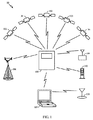
次に図1を参照すると、本教示の一態様によるSPSシステム10のブロック図が示されている。SPSシステム10は様々な衛星を含む。図1に示すように、衛星100〜104はSPSシステム10の一部として示されている。しかしながら、衛星100〜104の一部は、実際には追加のシステムに属し得る。それらは、様々な目的のために、SPSシステム10の一部として一緒に使用され得る。
Referring now to FIG. 1, a block diagram of an
モバイルデバイス105は、GPS、Galileo、GLONASS、GNSS、これらのシステムの組合せからの衛星を使用するシステム、または将来開発される任意のSPSなど、SPSからのものであり得る衛星100〜104からの信号を捕捉し、受信し、処理するように構成される。このSPS/PDS測位プロセスは、モバイルデバイス105が、BLUETOOTH(登録商標)送信機、802.11xワイヤレスアクセスポイント、フェムトセル、トランスポンダデバイス、デジタルテレビジョン(DTV)送信機、商用無線送信機(たとえば、FMまたはAM無線)など、任意の数の様々な送信機を含み得る、セルサイト106、ラップトップコンピュータ107、およびワイヤレス送信機109などの代替ソースからのロケーションデータを探索することで開始する。場合によっては、ロケーションデータは実際のロケーションに変換される。他の場合には、実際のロケーションではなくロケーションデータ自体が使用される。たとえば、2つのセルサイト測定間の到達時間差(TDOA)が受信され、使用され得る。
モバイルデバイス105は、単方向通信または双方向通信のいずれかにおいてセルサイト106との通信を確立することができる。モバイルデバイス105およびセルサイト106は、モバイル国コード(MCC)、基地局アルマナックにおいてセルのロケーションのルックアップを可能にするであろうセル識別子(ID)、緯度、経度および高度など、様々な形態のロケーションデータを与え得る。セルの緯度、経度および高度は、シードロケーションとして使用されるか、またはモバイルデバイスのシードロケーションを計算するために他のトランシーバからのロケーション、ならびにタイミングおよび/または信号強度情報と組み合わされ得る。単方向通信では、モバイルデバイス105は少なくともセルIDを受信する。セルサイトロケーションおよび関係するロケーション情報が通信プロバイダによってアクティブに維持されるとき、この情報は概して信頼できる。しかしながら、キャリアがセルサイト情報をアクティブに維持していないかまたは一意にプロビジョニングしていないとき、モバイルデバイス105によって受信されるロケーションデータは完全には信頼できないことがある。双方向通信中に、モバイルデバイス105は少なくともMCCとセルサイトIDとを受信する。双方向通信中に受信される情報は、モバイルデバイス105、セルサイト106、およびセルサイト106上で動作するネットワークの識別情報が検証されるので極めて信頼できる。この場合、基地局およびトランシーバのロケーションは、双方向通信を介して精度について検証され得る。
The
モバイルデバイス105はまた、追加のロケーションデータを取得するためにラップトップコンピュータ107との通信を確立する。モバイルデバイス105は、ラップトップコンピュータ107とのアドホック通信を確立し、ラップトップコンピュータ107と直接通信する。モバイルデバイス105は、利用可能なときに、ラップトップコンピュータ107からロケーションデータの2つのセットを受信し得る。ロケーションデータの第1のセットは、ラップトップコンピュータ107上で実行しているアプリケーションに記憶されたロケーションデータから来る。アプリケーションは、それの動作においてユーザによって入力されたロケーションデータをしばしば使用する。たとえば、ウェブエントリからのフォームデータはラップトップユーザのホームアドレスを含み得る。ロケーションデータの第2のセットは、ラップトップコンピュータ107も現在接続されている短距離ワイヤレス送信機108の識別子(ID)から来る。データのソースは、そのデータがシード位置を計算する際に使用されるべきかどうかに関する可能な考慮事項について識別されるであろう。たとえば、様々なロケーションソースがフォームデータ中のロケーションに整合する場合、フォームデータは、モバイルデバイスのロケーションである高い確率を有する。様々なロケーションソースが一致しない場合、フォームデータはおそらく関連性を有しない。ワイヤレス送信機109に関して言及した可能なデバイスのいずれかであり得る短距離ワイヤレス送信機108は、ロケーションにしばしば登録される識別子を与える。モバイルデバイス105は、短距離ワイヤレス送信機108からのIDを使用して、基地局アルマナック、またはトランシーバ識別子によって索引付けされたトランシーバロケーションと関連情報との他のテーブルにおいて関連するロケーションをルックアップする。このルックアップは、モバイルデバイス105上でローカルに記憶されたデータベースにおいて実行されるか、またはリモートデータベース110などのリモートデータベース上で実行され得る。このワイヤレスアクセスポイントID情報はまた、ワイヤレス送信機109との別個の接続を通して直接取得される。
The
ロケーションデータはまた、衛星100〜104のうちの1つまたは複数によって送信された衛星信号からモバイルデバイス105によって取得され得る。モバイルデバイス105は、SPS測位プロセスの捕捉部分以外でこれらの衛星信号を受信し得る。そのような場合、これらの衛星信号内のロケーションデータが使用される。衛星から受信されたときにすでに捕捉されている衛星ロケーションデータは極めて信頼できるが、捕捉以外で受信された情報はそれほど信頼できない。この情報は古いことがあり、またはモバイルデバイス105は、衛星信号から正確なロケーションデータを抽出するのに十分な情報を有しないことがある。
Location data may also be obtained by the
モバイルデバイス105はまた、前に記憶されたSPSロケーションデータからロケーションデータをローカルに受信する。モバイルデバイス105の動作の大部分では、前のSPS捕捉および測位プロセスからの記憶されたロケーションデータは概して正確である。しかしながら、この情報は、データのエイジが増加するにつれて信頼性を失う。記憶されたSPSロケーションデータを評価するとき、古いSPSロケーションデータが記憶された時間中に、モバイルデバイス105は、ある最大速度、すなわち、動きモデルにおいて移動し得るという仮定が行われる。たとえば、記憶されたSPSロケーション情報が20分だけ古い場合、動きモデルの最大速度は、自動車中で移動する最大速度、すなわち、約60〜80マイル毎時(mph)に等しいであろう。したがって、特定の記憶されたSPSロケーション情報のエイジにより5〜10マイルの最大移動距離しか推定されない場合、記憶されたSPSロケーション情報は依然として正確であり得る。対照的に、記憶されたSPSロケーション情報が1時間以上古いとき、飛行機旅行が関与し、動きモデルの最大移動速度はジェットライナーの最大移動速度まで増加し得ると仮定され得る。したがって、2時間のエイジをもつ記憶されたSPSロケーション情報は、前のロケーションから500〜600のマイル程度離れていると仮定されるであろう。この例では、記憶されたSPSロケーション情報は信頼できないおよび/または信用できないと仮定される。
The
モバイルデバイス105は、そのようなロケーション情報を集めるとき、データをSPS捕捉ルーチンに直ちに注入しない。代わりに、モバイルデバイス105は各独立したデータの整合性プロセスを実行する。ロケーション情報は、整合すると確認されたときのみ、SPS捕捉ルーチンに注入される。たとえば、テキサス州ダラスにおいて開始し、カリフォルニア州サンディエゴに飛行したユーザは、ユーザがモバイルデバイス105とともに最後に位置したテキサス州ダラスにおけるエリアを示す記憶されたSPSロケーションデータを有するであろう。モバイルデバイス105に記憶されたこの古いSPSロケーションデータを直ちに注入する代わりに、モバイルデバイス105は、セルサイト106、ラップトップコンピュータ107、およびワイヤレス送信機109から他のデータを収集する。このデータの比較時に、モバイルデバイス105は、モバイルデバイス105に記憶された前のSPSロケーションデータが、セルサイト106、ラップトップコンピュータ107、およびワイヤレス送信機109から受信された他のロケーションデータに整合しないことを発見する。この不整合のために、前に記憶されたSPSロケーション情報はモバイルデバイス105の捕捉および測位プロセスに注入されない。この結果は、モバイルデバイス105が、テキサス州ダラスの衛星ロケーション情報を使用して衛星を捕捉することを試み、次いで、予想されるロケーションにおいて衛星を発見することができないとき、かなりの待機期間後にタイムアウトする、前に説明した望ましくない状況を回避する。実際のロケーションではなくロケーションデータ(たとえば、TDOAデータ)が整合性プロセスのために使用される場合、シードロケーションは比較のために推定TDOAに変換され得る。
When the
図2は、本教示の一態様に従って構成されたモバイルデバイス20を示すブロック図である。モバイルデバイス20はプロセッサ200を含む。適用例または実装される特定の態様に応じて、プロセッサ200は、マイクロプロセッサ、マイクロコントローラ、デジタル信号プロセッサ、グラフィカル処理ユニットなどを含む、すべての処理ハードウェアを含み得る。モバイルデバイス20によって実行される処理機能はいずれもプロセッサ200によって実行される。モバイルデバイス20はまた、モバイルデバイス20上のユーザディスプレイ(図示せず)上へのデータのレンダリングを制御するディスプレイインターフェース202と、GPS受信機を含む様々なワイヤレスプロトコルに適合する複数のアンテナ203〜205と、メモリ201とを含む。
FIG. 2 is a block diagram illustrating a
メモリ201は、モバイルデバイス20の動作の基礎をなす様々なアプリケーションおよびオペレーティングシステムを記憶する。本教示の説明する態様に従って提供される様々な機能に関して、メモリ201は、プロセッサ200によって実行されたとき、モバイルデバイス20へのあるワイヤレス近接度内で発見されるワイヤレスデバイスからロケーションデータを検索することを試みるロケーション検索アプリケーション206を記憶する。本出願では、「近接度」は、所与の受信機のワイヤレス範囲またはアンテナ限界を意味するために使用される。メモリ201はまた、プロセッサ200によって実行されたとき、モバイルデバイス20のロケーション情報と比較的正確な時間情報とにすべて基づいて、予想される衛星信号がどこにあるかとそれらの予想される受信周波数が何であるかとを計算するために、捕捉および測位中に使用されるSPSプロセス207を記憶する。メモリ201はまた、プロセッサ200によって実行されたとき、モバイルデバイス20によって収集された独立したロケーションデータの各々を比較し、そのようなデータ中で識別されたトランシーバロケーションがモバイルデバイス20の仮定シードロケーションに整合するか否かを判断する、整合性プロセス208を記憶する。
図2で説明する態様はまた、信頼性階層209をメモリ201に記憶する。信頼性階層209は、どんなタイプのロケーションデータが考慮されているかに応じて段階的な信頼性レベルを与える。たとえば、WIFI(商標)識別子は低い信頼性レベルを有すると見なされ、MCCは、極めて高い信頼性レベルを有するが、より高い程度の不確実性をも有すると見なされる。本教示の様々な代替態様では、整合性プロセス208の基準を満たすために、収集されたデータのすべては、各トランシーバロケーションに関連する様々な程度の不確実性を考慮に入れて互いに整合することになる。信頼性階層209などの信頼性階層を使用することは、整合性プロセス208がはるかに複雑であることを可能にし、独立したロケーションデータのすべてが整合するわけではない状況においてロケーションデータ注入を可能にする。
The embodiment described in FIG. 2 also stores the
例示的な信頼性階層は、現在のSPS信号で開始し、その後に、最近記憶されたSPSロケーションデータ(すなわち、2秒前対10分前)、概して信頼性が同じであるMCCおよびセルサイトIDが続き得る。しかしながら、MCCデータは複数の近隣ロケーションの中で整合して発見されたが、セルサイトIDは整合しないことがわかったとき、MCCデータがより信頼できると見なされる、追加の論理がこの階層に挿入され得る。最後に、WIFI(商標)IDをもつ最も低い信頼性が発見されるであろう。動作中、次いで、モバイルデバイス20が様々な独立したロケーションデータを受信したとき、整合性プロセス208を実行することは、データの各々のロケーションデータを比較する。しかしながら、1つのデータを除いてすべてのデータが整合する場合、整合するトランシーバ/送信機ロケーションまたは関連する情報に基づいてシードロケーションを注入すべきか否かに関する、整合性プロセス208によって行われる判断は、整合するトランシーバ/送信機ロケーションまたは関連する情報に基づくことになる。一致しない複数のソースがある場合、信頼性階層209においてより上位にある信号ソースが選択され得る。代替的に、より広い初期探索ウィンドウが選択され得、与えられたトランシーバ/送信機ロケーションは無視され得る。たとえば、セルサイトID、MCC、およびWIFI(商標)IDはすべて整合するが、受信されたSPS信号が一致しない場合、整合性プロセス208は、データは整合しないと判断し、そのデータに基づくシードロケーションをSPSプロセス207に利用しないことを選択することになる。対照的に、SPS信号、MCC、セルサイトID、およびWIFI(商標)データはすべて整合するが、より古い記憶されたSPSロケーションデータが整合しない場合、より信頼できないより古い記憶されたSPSロケーションデータは、信頼性階層209のより下位にあるので廃棄されるべきであり、全体としてより信頼できるソースからのものである残りの整合するロケーションデータは、SPSプロセス207に注入されるべきであると整合性プロセス208は判断し得る。同様に、非キャリア提供WIFI(商標)ユニットは、一般に信頼性が低く、概して、基地局や、MCCなどの関係する基地局情報など、より高い信頼性ソースと整合しない場合は
無視されるであろう。
An exemplary reliability hierarchy starts with the current SPS signal, followed by recently stored SPS location data (i.e. 2 seconds before 10 minutes ago), generally MCC and cell site IDs with the same reliability Can continue. However, when the MCC data is found consistently in multiple neighboring locations, but the cell site ID is found to be inconsistent, additional logic is inserted into this hierarchy that makes the MCC data more reliable. Can be done. Finally, the lowest reliability with WIFI ™ ID will be found. During operation, then, when the
メモリ201はまた、登録トランシーバ/送信機ロケーションのロケーションの記録を維持するトランシーバデータベース210と、モバイルデバイス20上で動作可能な様々な追加のアプリケーションによって維持されるロケーションデータを表すロケーションデータ211と、現在時間の記録を維持する時間データ212と、前に記憶されたSPSロケーションデータを維持するSPSデータ213とを含み得る。
The
本教示の追加および/または代替の態様において、SPSプロセス207に注入すべきシードロケーションの判断をより正確にするために、より多くの複雑さが整合性プロセス208に追加され得ることに留意されたい。個々のトランシーバロケーションを利用する代わりに、注入すべきより正確なシードロケーションを作成するために、複数のトランシーバロケーション、およびタイミングや信号強度などの関係するトランシーバ情報が取られ、組み合わされ得る。たとえば、データの信頼性が確立されると、整合性プロセス208は、(セルサイトIDによって判断された)第1のセルサイトのロケーションと、短距離ワイヤレス送信機のロケーションと、ごく最近記憶されたSPS情報とを取り、モバイルデバイス20のより厳密なロケーションの推定値をシードロケーションとして計算する。次いで、このシードロケーションは、捕捉および測位プロセスのためにSPSプロセス207に注入される。
Note that in additional and / or alternative aspects of the present teachings, more complexity can be added to the
図3は、本教示の一態様を実装するために使用される機能ブロックを示すフローチャートである。機能ブロック300において、PDS受信機の位置を判断したいという要求を受信する。この要求に応答して、機能ブロック301において、PDS受信機に近接するワイヤレストランシーバ/送信機からロケーションデータを検索する。機能ブロック302において、異なるトランシーバ/送信機によって与えられたロケーションの整合性を判断するために、検索されたロケーションデータを比較する。機能ブロック303において、比較の結果、整合性が得られたかどうかの判断を行う。整合性は、送信レンジと、知られている場合、信号ソースの信号強度と、最近のロケーション計算データを考慮することとに照らして、異なるトランシーバがモバイルデバイスの共通推定ロケーションに整合するかどうかに基づいて判断される。整合性がある場合、機能ブロック304において、トランシーバ/送信機情報に基づいてシードロケーションを計算する。機能ブロック305において、このシードロケーションをPDS受信機の測位プロセスに注入する。そうではなく、整合性がないとき、ブロック306において、トランシーバ/送信機情報において少しでも整合性があるかどうかの別の判断を行う。何らかの整合性がある場合、次いで、機能ブロック307において整合する情報を使用し、機能ブロック304においてシードロケーションを計算し、そのシードロケーションをブロック305のPDS測位プロセスに注入する。整合性がまったくない場合、次いで、機能ブロック308において、整合しないデータを廃棄する。この時点で、随意の進行がある。整合しないデータを廃棄した後に、機能ブロック309において、最新の既知の正確なロケーションデータを使用して新しいシードロケーションを計算するか、または機能ブロック310において、補足ロケーションデータなしに続けるためにPDS測位プロセスをシグナリングする。
FIG. 3 is a flowchart illustrating functional blocks used to implement an aspect of the present teachings. In
本教示の追加の態様において、モバイルデバイスの粗いロケーションを取得または推定するために画像分析機能が使用され得ることに留意されたい。たとえば、ユーザがランドマークの写真を撮影し、その写真を受信者に送った場合、ネットワークは、写真のコピーを傍受し、その画像を、関連するデータベース中で維持されている既知のランドマークの画像およびロケーションと比較することができる。写真に関連するタイミング情報が、その写真が比較的短い時間期間内に撮影されたことを示す場合、ネットワークは、ランドマークの粗いロケーションを特定するためにそれの画像分析を開始する。次いで、ネットワークは、ロケーション情報の整合性について比較する際に使用するために、そのような粗位置情報をモバイルデバイスに送り得る。同様に、この特定の態様の変形体において、位置を判断したいという要求が行われたとき、モバイルデバイスはメモリ中の最近の写真を探索し得、妥当な時間期間内の写真が発見された場合、モバイルデバイスの可能な粗いロケーションを発見するための分析のために画像がネットワークに送信され得る。粗いロケーション情報を供給するために使用され得るそのような画像分析技術のさらに別の例は、様々なモバイルデバイス上で利用可能な画像探索機能によるものである。ユーザは、あるランドマークまたは建築物の写真を撮影したとき、オブジェクトのロケーションを含む、オブジェクトに関する追加情報を発見するために、ワイヤレスサービスプロバイダによって提供されるサービスを使用して探索し、データベース中のまたはインターネットに記憶された他の画像と比較する。そのような画像探索技術の例は、Google社のGOOGLE GOGGLES(商標)やVodafoneのOTELLO(商標)画像探索機能などのモバイルサービスにおいて発見される。 Note that in additional aspects of the present teachings, an image analysis function may be used to obtain or estimate the coarse location of the mobile device. For example, if a user takes a photo of a landmark and sends the photo to a recipient, the network intercepts a copy of the photo and captures the image for a known landmark maintained in the associated database. Can be compared with images and locations. If the timing information associated with a photo indicates that the photo was taken within a relatively short period of time, the network begins its image analysis to identify the coarse location of the landmark. The network may then send such coarse location information to the mobile device for use in comparing the consistency of location information. Similarly, in this particular mode variant, when a request is made to determine the location, the mobile device can search for a recent photo in memory and if a photo within a reasonable time period is found. Images can be sent to the network for analysis to discover possible coarse locations of the mobile device. Yet another example of such an image analysis technique that can be used to provide coarse location information is due to image search functionality available on various mobile devices. When a user takes a photo of a landmark or building, he searches using a service provided by the wireless service provider to find additional information about the object, including the location of the object, and in the database Or compare with other images stored on the Internet. Examples of such image search techniques are found in mobile services such as Google's GOOGLE GOGGLES ™ and Vodafone's OTELLO ™ image search function.
本教示の異なる態様の様々な実装形態では、シードロケーションの選択または計算は、様々な近隣モバイルデバイスから検索されたロケーション情報のうちの1つから行われ得ることに留意されたい。図4は、本教示の一態様を実装するために使用される機能ブロックを示すフローチャートである。機能ブロック400において、検索されたロケーションデータからの少なくともいくつかのデータの整合性を判断する。機能ブロック401において、整合するデータの受信元である各ワイヤレスデバイスの有効ワイヤレス範囲を比較する。ブロック402において、最も短い有効ワイヤレス範囲を有するワイヤレスデバイスから受信されたロケーションデータを選択する。ブロック403において、シードロケーションを、最も短いワイヤレス範囲を有するワイヤレスデバイスから選択されたロケーションデータに設定する。
Note that in various implementations of different aspects of the present teachings, the selection or calculation of the seed location may be made from one of the location information retrieved from various neighboring mobile devices. FIG. 4 is a flowchart illustrating functional blocks used to implement an aspect of the present teachings. In
本明細書で説明する方法は、適用例に応じて様々な手段によって実装され得る。たとえば、これらの方法は、ハードウェア、ファームウェア、ソフトウェア、またはそれらの任意の組合せで実装され得る。ハードウェア実装の場合、処理ユニットは、1つまたは複数の特定用途向け集積回路(ASIC)、デジタル信号プロセッサ(DSP)、デジタル信号処理デバイス(DSPD)、プログラマブル論理デバイス(PLD)、フィールドプログラマブルゲートアレイ(FPGA)、プロセッサ、コントローラ、マイクロコントローラ、マイクロプロセッサ、本明細書で説明する機能を実行するように設計された他の電子ユニット、またはそれらの組合せの中で実装され得る。 The methods described herein may be implemented by various means depending on the application. For example, these methods may be implemented in hardware, firmware, software, or any combination thereof. For hardware implementation, the processing unit is one or more application specific integrated circuits (ASICs), digital signal processors (DSPs), digital signal processing devices (DSPDs), programmable logic devices (PLDs), field programmable gate arrays (FPGA), processor, controller, microcontroller, microprocessor, other electronic unit designed to perform the functions described herein, or combinations thereof.
ファームウェアおよび/またはソフトウェア実装の場合、本方法は、本明細書で説明する機能を実行するモジュール(たとえば、プロシージャ、関数など)を用いて実装され得る。命令を有形に実施するいかなる機械またはコンピュータ可読媒体も、本明細書で説明する方法を実装する際に使用され得る。たとえば、ソフトウェアコードは、メモリに記憶され、プロセッサによって実行され得る。プロセッサによって実行されたとき、ソフトウェアコードを実行することは、本明細書で提示する教示の異なる態様の様々な方法および機能を実装する動作環境を生成する。メモリは、プロセッサの内部またはプロセッサの外部に実装され得る。本明細書で使用する「メモリ」という用語は、長期メモリ、短期メモリ、揮発性メモリ、不揮発性メモリ、または他のメモリのいずれかのタイプを指し、メモリの特定のタイプまたはメモリの数、あるいはメモリが記憶される媒体のタイプに限定されない。 For firmware and / or software implementations, the method may be implemented using modules (eg, procedures, functions, etc.) that perform the functions described herein. Any machine or computer readable medium that tangibly implements the instructions may be used in implementing the methods described herein. For example, software code may be stored in memory and executed by a processor. When executed by the processor, executing the software code generates an operating environment that implements various methods and functions of different aspects of the teachings presented herein. The memory can be implemented within the processor or external to the processor. As used herein, the term “memory” refers to any type of long-term memory, short-term memory, volatile memory, non-volatile memory, or other memory, a particular type or number of memories, or It is not limited to the type of medium in which the memory is stored.
本明細書で説明する方法および機能を定義するソフトウェアコードを記憶する機械またはコンピュータ可読媒体は、物理的コンピュータ記憶媒体を含む。記憶媒体は、コンピュータによってアクセスされ得る任意の利用可能な媒体であり得る。限定ではなく、例として、そのようなコンピュータ可読媒体は、RAM、ROM、EEPROM、CD-ROMまたは他の光ディスクストレージ、磁気ディスクストレージまたは他の磁気ストレージデバイス、あるいは命令またはデータ構造の形態の所望のプログラムコードを記憶するために使用され得、コンピュータによってアクセスされ得る、任意の他の媒体を含むことができる。本明細書で使用するディスク(disk)および/またはディスク(disc)は、コンパクトディスク (disc)(CD)、レーザディスク(登録商標)(disc)、光ディスク(disc)、デジタル多用途ディスク(disc)(DVD)、フレキシブルディスク(disk)およびブルーレイディスク(disc)を含み、ディスク(disk)は、通常、データを磁気的に再生し、ディスク(disc)は、データをレーザで光学的に再生する。上記の組合せもコンピュータ可読媒体の範囲内に含めるべきである。 Machine or computer readable media storing software code defining the methods and functions described herein include physical computer storage media. A storage media may be any available media that can be accessed by a computer. By way of example, and not limitation, such computer readable media can be RAM, ROM, EEPROM, CD-ROM or other optical disk storage, magnetic disk storage or other magnetic storage device, or any desired form in the form of instructions or data structures. Any other medium that can be used to store program code and that can be accessed by a computer can be included. As used herein, a disk and / or a disc is a compact disc (CD), a laser disc (registered trademark) (disc), an optical disc (disc), or a digital versatile disc (disc). (DVD), flexible disk (disk) and Blu-ray disk (disc), the disk normally reproduces data magnetically, and the disk optically reproduces data with a laser. Combinations of the above should also be included within the scope of computer-readable media.
コンピュータ可読媒体上での記憶に加えて、命令および/またはデータは、通信装置中に含まれる伝送媒体上の信号として与えられ得る。たとえば、通信装置は、命令とデータとを示す信号を有するトランシーバを含み得る。命令およびデータは、1つまたは複数のプロセッサに、特許請求の範囲で概説する機能を実装させるように構成される。とはいえ、通信装置は、命令および/またはデータのすべてをコンピュータ可読媒体に記憶し得るわけではない。 In addition to storage on computer readable media, instructions and / or data may be provided as signals on a transmission medium included in the communication device. For example, the communication device may include a transceiver having signals indicative of instructions and data. The instructions and data are configured to cause one or more processors to implement the functions outlined in the claims. Nevertheless, a communication device may not store all of the instructions and / or data on a computer readable medium.
図5に、いくつかの態様による、PDS受信機をその中に実装するために採用され得る例示的なコンピュータシステム500を示す。中央処理ユニット(「CPU」または「プロセッサ」)501はシステムバス502に結合される。CPU501は任意の汎用プロセッサであり得る。本開示は、CPU501(およびシステム500の他の構成要素)が本明細書で説明する動作をサポートする限り、CPU501(または例示的なシステム500の他の構成要素)のアーキテクチャによって制限されない。したがって、CPU501は、1つまたは複数のプロセッサまたはプロセッサコアによってシステム500の処理を行い得る。CPU501は、本明細書で説明する様々な論理命令を実行し得る。たとえば、CPU501は、図3および図4に関連して上記で説明した例示的な動作フローに従って機械レベル命令を実行し得る。図3および図4に示す動作ブロックを表す命令を実行するときに、CPU501は、本明細書で説明する教示の様々な態様に従って動作するように特に構成された特殊目的コンピューティングプラットフォームの専用プロセッサになる。
FIG. 5 illustrates an
コンピュータシステム500はまた、SRAM、DRAM、SDRAMなどであり得るランダムアクセスメモリ(RAM)503を含む。コンピュータシステム500は、PROM、EPROM、EEPROMなどであり得る読取り専用メモリ(ROM)504を含む。RAM503およびROM504は、当技術分野でよく知られているように、ユーザおよびシステムデータならびにプログラムを保持する。
コンピュータシステム500はまた、入出力(I/O)アダプタ505と、通信アダプタ511と、ユーザインターフェースアダプタ508と、ディスプレイアダプタ509とを含む。入出力アダプタ505、ユーザインターフェースアダプタ508、および/または通信アダプタ511は、いくつかの態様では、ユーザが情報を入力するためにコンピュータシステム500と対話することを可能にし得る。通信モジュール/トランシーバ517は無線周波通信機能をコンピュータシステム500に与える。GPS受信機518は、様々な衛星測位システムにおいて取得されるべき衛星対応測位情報を与える。
入出力アダプタ505は、ハードドライブ、コンパクトディスク(CD)ドライブ、フレキシブルディスクドライブ、テープドライブなどのうちの1つまたは複数などのストレージデバイス506をコンピュータシステム500に結合する。ストレージデバイスは、本教示の様々な態様に従って構成されたSPS受信機に関連する動作を実行することに関連するメモリ要件のために、RAM503に加えて利用される。通信アダプタ511は、コンピュータシステム500をネットワーク512に結合するように適応され、これは、情報がネットワーク512(たとえば、インターネットまたは他のワイドエリアネットワーク、ローカルエリアネットワーク、公衆またはプライベート交換電話網、ワイヤレスネットワーク、上記のいずれかの組合せ)を介してシステム500に入力されおよび/またはシステム500から出力されることを可能にし得る。ユーザインターフェースアダプタ508は、キーボード513、ポインティングデバイス507、およびマイクロフォン514などのユーザ入力デバイスならびに/あるいはスピーカー515などの出力デバイスをコンピュータシステム500に結合する。ディスプレイアダプタ509は、たとえば、得られたPDS受信機ロケーションを表示するためのディスプレイデバイス510上での表示を制御するために、プロセッサ501によってまたはグラフィカル処理ユニット(GPU)516によって駆動される。GPU516は、グラフィックス処理に専用の様々な数のプロセッサのいずれかであり得、図示のように、1つまたは複数の個別のグラフィカルプロセッサからなり得る。GPU516は、グラフィカル命令を処理し、それらの命令をディスプレイアダプタ509に送信する。ディスプレイアダプタ509は、ユーザに所望の情報を視覚的に提示するために、ディスプレイデバイス510によって使用される様々な数のピクセルの状態を変換または操作するための命令をさらに送信する。そのような命令は、状態をオンからオフに変更するための命令、特定の色、輝度、持続時間などを設定するための命令を含む。そのような各命令は、ディスプレイデバイス510上で何がどのように表示されるかを制御するレンダリング命令を構成する。
Input /
本開示はシステム500のアーキテクチャに限定されないことを諒解されたい。たとえば、限定はしないが、パーソナルコンピュータ、ラップトップコンピュータ、コンピュータワークステーション、マルチプロセッササーバ、さらには携帯電話を含む、任意の好適なプロセッサベースのデバイスがPDSを実装するために利用され得る。その上、いくつかの態様は、特定用途向け集積回路(ASIC)または超大規模集積(VLSI)回路上に実装され得る。事実上、当業者は、それらの態様に従って論理演算を実行することが可能な任意の数の好適な構造を利用し得る。
It should be appreciated that the present disclosure is not limited to the architecture of
本教示およびそれらの利点について詳細に説明したが、添付の特許請求の範囲によって規定される本教示の技術から逸脱することなく様々な変更、置換および改変を本明細書で行うことができることを理解されたい。さらに、本出願の範囲は、本明細書で説明するプロセス、機械、製造、組成物、手段、方法およびステップの特定の態様に限定されるものではない。当業者なら本開示から容易に諒解するように、本明細書で説明した対応する態様と実質的に同じ機能を実行するか、または実質的に同じ結果を達成する、現存するかまたは後で開発される、プロセス、機械、製造、組成物、手段、方法、またはステップは本教示に従って利用され得る。したがって、添付の特許請求の範囲は、それらの範囲内にそのようなプロセス、機械、製造、組成物、手段、方法、またはステップを含むものとする。 Although the present teachings and their advantages have been described in detail, it will be understood that various changes, substitutions and modifications can be made herein without departing from the techniques of the present teachings as defined by the appended claims. I want to be. Further, the scope of the present application is not limited to the particular aspects of the processes, machines, manufacture, compositions, means, methods and steps described herein. Those skilled in the art will readily appreciate from the present disclosure that perform substantially the same function as the corresponding aspects described herein, or achieve substantially the same result, existing or later developed Any process, machine, manufacture, composition, means, method, or step that may be employed may be utilized in accordance with the present teachings. Accordingly, the appended claims are intended to include within their scope such processes, machines, manufacture, compositions of matter, means, methods, or steps.
10 SPSシステム
20 モバイルデバイス
100 衛星
101 衛星
102 衛星
103 衛星
104 衛星
105 モバイルデバイス
106 セルサイト
107 ラップトップコンピュータ
108 短距離ワイヤレス送信機
109 ワイヤレス送信機
110 リモートデータベース
200 プロセッサ
201 メモリ
202 ディスプレイインターフェース
203 アンテナ
204 アンテナ
205 アンテナ
206 ロケーション検索アプリケーション
207 SPSプロセス
208 整合性プロセス
209 信頼性階層
210 トランシーバデータベース
211 ロケーションデータ
212 時間データ
213 SPSデータ
500 コンピュータシステム
501 中央処理ユニット
502 システムバス
503 ランダムアクセスメモリ(RAM)
504 読取り専用メモリ(ROM)
505 入出力アダプタ
506 ストレージデバイス
507 ポインティングデバイス
508 ユーザインターフェースアダプタ
509 ディスプレイアダプタ
510 ディスプレイデバイス
511 通信アダプタ
512 ネットワーク
513 キーボード
514 マイクロフォン
515 スピーカー
516 グラフィカル処理ユニット(GPU)
517 通信モジュール/トランシーバ
518 GPS受信機
10 SPS system
20 Mobile devices
100 satellites
101 satellites
102 satellites
103 satellites
104 satellites
105 Mobile devices
106 Cell site
107 laptop computer
108 short range wireless transmitter
109 wireless transmitter
110 Remote database
200 processors
201 memory
202 Display interface
203 Antenna
204 Antenna
205 Antenna
206 Location Search Application
207 SPS process
208 Consistency process
209 Reliability Hierarchy
210 Transceiver database
211 Location data
212 time data
213 SPS data
500 computer system
501 Central processing unit
502 system bus
503 Random access memory (RAM)
504 Read-only memory (ROM)
505 I / O adapter
506 storage device
507 pointing device
508 user interface adapter
509 display adapter
510 display devices
511 Communication adapter
512 network
513 keyboard
514 microphone
515 Speaker
516 Graphical Processing Unit (GPU)
517 Communication Module / Transceiver
518 GPS receiver
Claims (24)
PDS受信機の位置を判断したいという要求を受信するステップと、
前記要求に応答して、前記PDS受信機に近接する複数のワイヤレスデバイスからロケーションデータを検索するステップと、
前記検索されたロケーションデータと共通シードロケーションとの整合性を判断するために前記検索されたロケーションデータを比較するステップと、
前記検索されたロケーションデータが前記共通シードロケーションに整合すると判断したことに応答して、前記共通シードロケーションを前記PDS受信機の測位プロセスに注入するステップと
を含む、方法。 A method for position determination in a position determination system (PDS),
Receiving a request to determine the position of the PDS receiver;
In response to the request, retrieving location data from a plurality of wireless devices proximate to the PDS receiver;
Comparing the retrieved location data to determine the consistency between the retrieved location data and a common seed location;
Injecting the common seed location into the positioning process of the PDS receiver in response to determining that the retrieved location data matches the common seed location.
前記検索されたロケーションデータが整合すると判断したことに応答して、前記検索されたロケーションデータに基づいて新しいシードロケーションを計算するステップと、
前記新しいシードロケーションを前記測位プロセスに注入するステップと
をさらに含む、請求項1に記載の方法。 In response to determining that the retrieved location data does not match the common seed location, comparing the retrieved location data to determine the integrity of the retrieved location data;
Responsive to determining that the retrieved location data is consistent, calculating a new seed location based on the retrieved location data;
2. The method of claim 1, further comprising injecting the new seed location into the positioning process.
前記検索されたロケーションデータのタイプの信頼性階層に従って前記検索されたロケーションデータの各々を比較するステップ
を含む、請求項2に記載の方法。 Said comparing step comprises:
3. The method of claim 2, comprising comparing each of the retrieved location data according to a reliability hierarchy of the retrieved location data type.
モバイル国コード(MCC)と、
セルサイト識別子(ID)と、
PDS信号と、
短距離ワイヤレス送信機IDと、
テレビジョン放送送信機IDと、
商用無線放送送信機IDと
を含む、請求項3に記載の方法。 The type of the retrieved location data is
Mobile country code (MCC),
Cell site identifier (ID)
PDS signal and
Short-range wireless transmitter ID,
Television broadcast transmitter ID,
4. The method of claim 3, comprising a commercial radio broadcast transmitter ID.
をさらに含む、請求項3に記載の方法。 The method of claim 3, further comprising searching the database using an index to a database of location data, wherein the index is associated with the type of the searched location data. Method.
をさらに含み、前記方法が、
前記低い信頼性を有する前記タイプから発生した前記検索されたロケーションデータのうちの前記整合しないロケーションデータを除去するステップと、
除去されない前記検索されたロケーションデータのうちの前記残りのロケーションデータが前記検索されたロケーションデータの前記整合性を有することを判断するステップと
をさらに含む、請求項3に記載の方法。 Determining when inconsistent location data of the retrieved location data originates from the type having low reliability according to the reliability hierarchy, the method comprising:
Removing the inconsistent location data of the searched location data generated from the type having the low reliability;
4. The method of claim 3, further comprising: determining that the remaining location data of the retrieved location data that is not removed has the consistency of the retrieved location data.
前記改良されたロケーションを前記新しいシードロケーションとして使用するステップと
をさらに含む、請求項2に記載の方法。 Using the location information from each of the retrieved location data determined to be consistent, calculating an improved location;
3. The method of claim 2, further comprising using the improved location as the new seed location.
最も近い前記予測検出可能性範囲を有する前記複数のワイヤレスデバイスのうちの1つから受信された、前記検索されたロケーションデータのうちの前記少なくとも2つのうちの1つとして前記新しいシードロケーションを選択するステップと
をさらに含む、請求項2に記載の方法。 In response to determining that at least two of the retrieved location data matches, the prediction of each of the plurality of wireless devices that are the source of the at least two of the matching searched location data Comparing the detectability ranges;
Selecting the new seed location as one of the at least two of the searched location data received from one of the plurality of wireless devices having the closest predictive detectability range The method of claim 2, further comprising:
プロセッサと、
メモリと、
前記メモリに記憶されたロケーション検索アプリケーションであって、前記プロセッサによって実行されたとき、前記SPS受信機に近接する複数のワイヤレスデバイスから複数のロケーションデータを取得するように前記SPS受信機を構成するロケーション検索アプリケーションと、
前記メモリに記憶された整合性プロセスであって、前記プロセッサによって実行されたとき、前記複数のロケーションデータが共通シードロケーションに整合するかどうかを判断する整合性プロセスと、
SPSプロセスであって、前記プロセッサによって実行されたとき、前記SPS受信機のグローバル位置を判断するために使用される少なくとも1つのSPS衛星の位置を特定するためのパラメータを判断するSPSプロセスとを含み、前記複数のロケーションデータが前記共通シードロケーションに整合すると前記実行整合性プロセスが判断したとき、前記共通シードロケーションが前記SPSプロセスに注入される、
衛星測位システム(SPS)受信機。 A satellite positioning system (SPS) receiver,
A processor;
Memory,
A location search application stored in the memory, wherein when executed by the processor, a location that configures the SPS receiver to obtain a plurality of location data from a plurality of wireless devices proximate to the SPS receiver. A search application,
A consistency process stored in the memory for determining whether the plurality of location data matches a common seed location when executed by the processor;
An SPS process that, when executed by the processor, determines a parameter for determining a position of at least one SPS satellite used to determine a global position of the SPS receiver. The common seed location is injected into the SPS process when the execution consistency process determines that the plurality of location data matches the common seed location;
Satellite positioning system (SPS) receiver.
前記複数のロケーションデータのうちの前記少なくとも2つが整合すると判断したことに応答して、前記整合性プロセスは、前記複数のロケーションデータのうちの前記整合する少なくとも2つに基づいて、前記SPSプロセスに注入される新しいシードロケーションを計算する、
請求項9に記載のSPS受信機。 The consistency process further determines whether at least two of the plurality of location data are consistent when the plurality of location data are found to be inconsistent with the common seed location;
Responsive to determining that the at least two of the plurality of location data are consistent, the consistency process is responsive to the SPS process based on the at least two of the plurality of location data to be consistent. Calculate the new seed location to be injected,
The SPS receiver according to claim 9.
請求項10に記載のSPS受信機。 A reliability hierarchy stored in the memory, the reliability hierarchy identifying a set of data types configured according to a reliability level, wherein when executed by the processor, the consistency process Further configured to rank the compared plurality of location data according to sex hierarchy, discarding inconsistent location data of the plurality of location data having a lower rank in the reliability hierarchy, and Further configured to group matching higher rank location data of the location data into matching location data;
The SPS receiver according to claim 10.
最も近い前記予測検出可能性範囲を有する前記複数のワイヤレスデバイスのうちの1つから受信された、前記複数のロケーションデータのうちの前記少なくとも2つのうちの1つとして前記新しいシードロケーションを選択する、
請求項10に記載のSPS受信機。 In response to determining that at least two of the plurality of location data are consistent, the step of performing a consistency process is the at least two matching sources of the plurality of location data. Compare the predictability range of each of multiple wireless devices,
Selecting the new seed location as one of the at least two of the plurality of location data received from one of the plurality of wireless devices having the closest predictive detectability range;
The SPS receiver according to claim 10.
請求項9に記載のSPS受信機。 Further comprising a plurality of antennas, wherein each of the plurality of location data is received using a corresponding one of the plurality of antennas;
The SPS receiver according to claim 9.
前記要求に応答して実行可能な、前記PDS受信機に近接する複数のワイヤレスデバイスからロケーションデータを検索するためのプログラムコードと、
前記検索されたロケーションデータと共通シードロケーションとの整合性を判断するために前記検索されたロケーションデータを比較するためのプログラムコードと、
前記検索されたロケーションデータが前記共通シードロケーションに整合すると判断したことに応答して実行可能な、前記共通シードロケーションを前記PDS受信機の測位プロセスに注入するためのプログラムコードと
を含む、そこに記憶されたプログラムコードを含むコンピュータ可読媒体。 Program code for receiving a request to determine the position of the PDS receiver;
Program code for retrieving location data from a plurality of wireless devices proximate to the PDS receiver, executable in response to the request;
Program code for comparing the retrieved location data to determine consistency between the retrieved location data and a common seed location;
Program code for injecting the common seed location into the positioning process of the PDS receiver, executable in response to determining that the retrieved location data matches the common seed location. A computer readable medium containing stored program code.
前記検索されたロケーションデータが整合すると判断したことに応答して実行可能な、前記検索されたロケーションデータに基づいて新しいシードロケーションを計算するためのプログラムコードと、
前記新しいシードロケーションを前記測位プロセスに注入するためのプログラムコードと
をさらに含む、請求項15に記載のコンピュータ可読媒体。 To compare the retrieved location data to determine the consistency of the retrieved location data that can be performed in response to determining that the retrieved location data does not match the common seed location. Program code,
Program code for calculating a new seed location based on the retrieved location data, executable in response to determining that the retrieved location data is consistent;
16. The computer readable medium of claim 15, further comprising program code for injecting the new seed location into the positioning process.
前記検索されたロケーションデータのタイプの信頼性階層に従って前記検索されたロケーションデータの各々を比較するためのプログラムコード
を含む、請求項16に記載のコンピュータ可読媒体。 The program code for comparing the retrieved location data to determine the consistency of the retrieved location data;
17. The computer-readable medium of claim 16, comprising program code for comparing each of the retrieved location data according to a reliability hierarchy of the retrieved location data type.
モバイル国コード(MCC)と、
セルサイト識別子(ID)と、
PDS信号と、
短距離ワイヤレス送信機IDと、
テレビジョン放送送信機IDと、
商用無線放送送信機IDと
を含む、請求項17に記載のコンピュータ可読媒体。 The type of location data retrieved is
Mobile country code (MCC),
Cell site identifier (ID)
PDS signal and
Short-range wireless transmitter ID,
Television broadcast transmitter ID,
18. The computer readable medium of claim 17, comprising a commercial radio broadcast transmitter ID.
をさらに含む、請求項17に記載のコンピュータ可読媒体。 Program code for searching the database using an index into a database of location data, the index further comprising program code for searching, wherein the index is associated with the type of the searched location data. The computer readable medium of claim 17.
前記低い信頼性を有する前記タイプから発生した前記検索されたロケーションデータのうちの前記整合しないロケーションデータを除去するためのプログラムコードと、
除去されない前記検索されたロケーションデータのうちの前記残りのロケーションデータが前記検索されたロケーションデータの前記整合性を有することを判断するためのプログラムコードと
をさらに含む、請求項17に記載のコンピュータ可読媒体。 Program code for determining when inconsistent location data of the retrieved location data originated from the type having low reliability according to the reliability hierarchy;
Program code for removing the inconsistent location data of the retrieved location data generated from the type having the low reliability;
18. Computer readable data according to claim 17, further comprising program code for determining that the remaining location data of the retrieved location data that is not removed has the integrity of the retrieved location data. Medium.
前記改良されたロケーションを前記新しいシードロケーションとして使用するためのプログラムコードと
をさらに含む、請求項16に記載のコンピュータ可読媒体。 Program code for calculating an improved location using location information from each of the retrieved location data determined to be consistent;
17. The computer readable medium of claim 16, further comprising program code for using the improved location as the new seed location.
最も近い前記予測検出可能性範囲を有する前記複数のワイヤレスデバイスのうちの1つから受信された、前記検索されたロケーションデータのうちの前記少なくとも2つのうちの1つとして前記新しいシードロケーションを選択するためのプログラムコードと
をさらに含む、請求項16に記載のコンピュータ可読媒体。 Of the plurality of wireless devices from which the at least two of the matched searched location data are executable in response to determining that at least two of the searched location data match. Program code for comparing the respective predictability ranges;
Selecting the new seed location as one of the at least two of the searched location data received from one of the plurality of wireless devices having the closest predictive detectability range 17. The computer readable medium of claim 16, further comprising program code for:
前記PDS受信機の位置を要求する入力を受信するための手段と、
前記PDS受信機に近接する複数のワイヤレスデバイスからロケーション情報をワイヤレスに検索するための手段と、
前記検索されたロケーション情報と、
前記検索されたロケーション情報と共通シードロケーションとの整合性を判断するためのプログラムコードと、
PDS測位プロセスを定義するためのプログラムコードと
を記憶するためのコンピュータ可読記憶手段と、
整合性を判断するための前記プログラムコードと前記PDS測位プロセスを定義するための前記プログラムコードとを処理するための手段であって、整合性を判断するための前記処理されたプログラムコードが前記検索されたロケーション情報と前記共通シードロケーションとの間の整合性を発見したときに前記共通シードロケーションを前記PDS測位プロセスに注入する、処理するための手段と
を含む位置判断システム(PDS)受信機。 A position determination system (PDS) receiver,
Means for receiving an input requesting a position of the PDS receiver;
Means for wirelessly retrieving location information from a plurality of wireless devices proximate to the PDS receiver;
The retrieved location information;
Program code for determining consistency between the retrieved location information and a common seed location;
Computer readable storage means for storing program code for defining a PDS positioning process;
Means for processing the program code for determining consistency and the program code for defining the PDS positioning process, wherein the processed program code for determining consistency is the search A position determination system (PDS) receiver comprising: means for injecting the common seed location into the PDS positioning process when a match is found between the generated location information and the common seed location.
整合性を判断するための前記処理されたプログラムコードが前記検索されたロケーション情報と前記共通シードロケーションとの間の不整合を発見したことに応答して、整合性を判断するための前記プログラムコードがさらに、前記検索されたロケーション情報の整合性を判断するために前記検索されたロケーション情報を比較し、
前記検索されたロケーション情報が整合すると判断したことに応答して、整合性を判断するための前記処理されたプログラムコードが、前記検索されたロケーション情報に基づいて新しいシードロケーションを計算し、
処理するための前記手段が、前記新しいシードロケーションを、PDS測位プロセスを定義するための前記プログラムコードに注入する、
請求項23に記載のPDS受信機。 The means for processing determines the common seed location when the processed program code for determining consistency finds a mismatch between the retrieved location information and the common seed location. Do not inject into the PDS positioning process,
The program code for determining consistency in response to the processed program code for determining consistency finding a mismatch between the retrieved location information and the common seed location Further compares the retrieved location information to determine the consistency of the retrieved location information;
In response to determining that the retrieved location information is consistent, the processed program code for determining consistency calculates a new seed location based on the retrieved location information;
The means for processing injects the new seed location into the program code for defining a PDS positioning process;
24. The PDS receiver according to claim 23.
Applications Claiming Priority (5)
| Application Number | Priority Date | Filing Date | Title |
|---|---|---|---|
| US25162909P | 2009-10-14 | 2009-10-14 | |
| US61/251,629 | 2009-10-14 | ||
| US12/786,103 US8259010B2 (en) | 2009-10-14 | 2010-05-24 | Qualifying coarse position injection in position determination systems |
| US12/786,103 | 2010-05-24 | ||
| PCT/US2010/052732 WO2011047193A2 (en) | 2009-10-14 | 2010-10-14 | Qualifying coarse position injection in position determination systems |
Related Child Applications (1)
| Application Number | Title | Priority Date | Filing Date |
|---|---|---|---|
| JP2013137816A Division JP5837004B2 (en) | 2009-10-14 | 2013-07-01 | Limiting coarse position injection in position determination systems |
Publications (2)
| Publication Number | Publication Date |
|---|---|
| JP2013508684A true JP2013508684A (en) | 2013-03-07 |
| JP2013508684A5 JP2013508684A5 (en) | 2013-08-22 |
Family
ID=43854438
Family Applications (2)
| Application Number | Title | Priority Date | Filing Date |
|---|---|---|---|
| JP2012534371A Pending JP2013508684A (en) | 2009-10-14 | 2010-10-14 | Limiting coarse position injection in position determination systems |
| JP2013137816A Active JP5837004B2 (en) | 2009-10-14 | 2013-07-01 | Limiting coarse position injection in position determination systems |
Family Applications After (1)
| Application Number | Title | Priority Date | Filing Date |
|---|---|---|---|
| JP2013137816A Active JP5837004B2 (en) | 2009-10-14 | 2013-07-01 | Limiting coarse position injection in position determination systems |
Country Status (7)
| Country | Link |
|---|---|
| US (1) | US8259010B2 (en) |
| EP (2) | EP2680038B1 (en) |
| JP (2) | JP2013508684A (en) |
| KR (2) | KR101456081B1 (en) |
| CN (2) | CN103399328B (en) |
| TW (1) | TW201124745A (en) |
| WO (1) | WO2011047193A2 (en) |
Cited By (2)
| Publication number | Priority date | Publication date | Assignee | Title |
|---|---|---|---|---|
| JP2014181911A (en) * | 2013-03-18 | 2014-09-29 | Casio Comput Co Ltd | Gps receiving apparatus and program |
| JP2018004302A (en) * | 2016-06-28 | 2018-01-11 | 株式会社日立国際八木ソリューションズ | Position detector |
Families Citing this family (11)
| Publication number | Priority date | Publication date | Assignee | Title |
|---|---|---|---|---|
| US8558738B2 (en) * | 2008-05-22 | 2013-10-15 | Novatel Inc. | GNSS receiver using signals of opportunity and assistance information to reduce the time to first fix |
| KR101573374B1 (en) * | 2008-11-06 | 2015-12-01 | 삼성전자주식회사 | Method and system for positioning mobile terminal using secure user plane location |
| US8531332B2 (en) * | 2010-03-22 | 2013-09-10 | Qualcomm Incorporated | Anti-spoofing detection system |
| CN102390410A (en) * | 2011-06-23 | 2012-03-28 | 中国北车股份有限公司大连电力牵引研发中心 | Vehicle monitoring system based on Beidou system and control method thereof |
| GB2497802A (en) * | 2011-12-22 | 2013-06-26 | Renesas Mobile Corp | Position determination |
| US8855681B1 (en) * | 2012-04-20 | 2014-10-07 | Amazon Technologies, Inc. | Using multiple applications to provide location information |
| US10386490B2 (en) | 2012-07-16 | 2019-08-20 | Microsoft Technology Licensing, Llc | Reduced sampling low power GPS |
| US10317538B2 (en) | 2013-08-27 | 2019-06-11 | Microsoft Technology Licensing, Llc | Cloud-offloaded global satellite positioning |
| US9671499B2 (en) | 2013-10-30 | 2017-06-06 | Microsoft Technology Licensing, Llc | High-sensitivity GPS device with directional antenna |
| CN108957506A (en) * | 2018-07-15 | 2018-12-07 | 合肥市智信汽车科技有限公司 | A kind of vehicle positioning method and device |
| US20220357464A1 (en) * | 2021-05-10 | 2022-11-10 | Qualcomm Incorporated | Determining position information of mobile devices |
Citations (3)
| Publication number | Priority date | Publication date | Assignee | Title |
|---|---|---|---|---|
| JP2000137066A (en) * | 1998-10-30 | 2000-05-16 | Matsushita Electric Works Ltd | Gps receiving device |
| JP2001133535A (en) * | 1999-11-02 | 2001-05-18 | Seiko Epson Corp | Information terminal and positioning method |
| JP2004279314A (en) * | 2003-03-18 | 2004-10-07 | Seiko Epson Corp | Information terminal device, control method of information terminal device, control program of information terminal device, computer-readable recording medium recording control program of information terminal device |
Family Cites Families (35)
| Publication number | Priority date | Publication date | Assignee | Title |
|---|---|---|---|---|
| US5488559A (en) * | 1993-08-02 | 1996-01-30 | Motorola, Inc. | Map-matching with competing sensory positions |
| US5774829A (en) * | 1995-12-12 | 1998-06-30 | Pinterra Corporation | Navigation and positioning system and method using uncoordinated beacon signals in conjunction with an absolute positioning system |
| US6249252B1 (en) * | 1996-09-09 | 2001-06-19 | Tracbeam Llc | Wireless location using multiple location estimators |
| US5999124A (en) * | 1998-04-22 | 1999-12-07 | Snaptrack, Inc, | Satellite positioning system augmentation with wireless communication signals |
| US5982324A (en) * | 1998-05-14 | 1999-11-09 | Nortel Networks Corporation | Combining GPS with TOA/TDOA of cellular signals to locate terminal |
| US6515617B1 (en) * | 1998-09-01 | 2003-02-04 | Hughes Electronics Corporation | Method and system for position determination using geostationary earth orbit satellite |
| US6184829B1 (en) * | 1999-01-08 | 2001-02-06 | Trueposition, Inc. | Calibration for wireless location system |
| JP3520409B2 (en) * | 1999-10-07 | 2004-04-19 | セイコーエプソン株式会社 | Current location system and current location method |
| US6289280B1 (en) * | 1999-12-10 | 2001-09-11 | Qualcomm Incorporated | Method and apparatus for determining an algebraic solution to GPS terrestrial hybrid location system equations |
| US6420999B1 (en) * | 2000-10-26 | 2002-07-16 | Qualcomm, Inc. | Method and apparatus for determining an error estimate in a hybrid position determination system |
| US6525687B2 (en) * | 2001-02-12 | 2003-02-25 | Enuvis, Inc. | Location-determination method and apparatus |
| US7576692B2 (en) * | 2001-02-23 | 2009-08-18 | Nokia Corporation | Method for positioning, a positioning system, and an electronic device |
| US6473030B1 (en) * | 2001-02-28 | 2002-10-29 | Seiko Epson Corporation | Infrastructure-aiding for satellite navigation receiver and method |
| US20020142783A1 (en) | 2001-03-28 | 2002-10-03 | Yoldi Cesar Sanchez | Reduced acquisition time for GPS cold and warm starts |
| US6865395B2 (en) | 2002-08-08 | 2005-03-08 | Qualcomm Inc. | Area based position determination for terminals in a wireless network |
| CN103792554B (en) * | 2003-04-25 | 2019-07-19 | 高通股份有限公司 | The system and method for obtaining signal acquisition assistance data |
| JP2005207941A (en) * | 2004-01-23 | 2005-08-04 | Seiko Epson Corp | POSITIONING DEVICE, MOBILE TERMINAL, POSITIONING METHOD, AND POSITIONING PROGRAM |
| JP2005321345A (en) * | 2004-05-11 | 2005-11-17 | Seiko Epson Corp | POSITIONING SYSTEM, POSITIONING METHOD, TERMINAL DEVICE, TERMINAL DEVICE CONTROL METHOD, TERMINAL DEVICE CONTROL PROGRAM, COMPUTER-READABLE RECORDING MEDIUM CONTAINING TERMINAL DEVICE CONTROL PROGRAM, FIXED DEVICE, FIXED DEVICE CONTROL PROGRAM |
| JP2006090838A (en) * | 2004-09-24 | 2006-04-06 | Seiko Epson Corp | POSITIONING SYSTEM, POSITIONING DEVICE, POSITIONING INFORMATION PROVIDING DEVICE, POSITIONING METHOD, POSITIONING SYSTEM CONTROL PROGRAM, COMPUTER-READABLE RECORDING MEDIUM CONTAINING POSITIONING SYSTEM CONTROL PROGRAM |
| US7450064B2 (en) * | 2005-03-22 | 2008-11-11 | Qualcomm, Incorporated | Methods and systems for deriving seed position of a subscriber station in support of unassisted GPS-type position determination in a wireless communication system |
| US7656352B2 (en) * | 2005-09-20 | 2010-02-02 | Novariant, Inc. | Troposphere corrections for ground based positioning systems |
| US20070132639A1 (en) * | 2005-12-09 | 2007-06-14 | Korneluk Jose E | Method and apparatus for determining an approximate position of a satellite positioning receiver |
| US20070132636A1 (en) * | 2005-12-14 | 2007-06-14 | Motorola, Inc. | Multi-receiver satellite positioning system method and system for improved performance |
| US20070182631A1 (en) * | 2006-02-09 | 2007-08-09 | Berlinsky Allan M | Internet based assisted global positioning system |
| US7710318B2 (en) * | 2006-08-24 | 2010-05-04 | Sirf Technology | Method of enhanced cold start and associated user interface for navigational receivers |
| US20080111737A1 (en) * | 2006-11-15 | 2008-05-15 | Motorola Inc. | Method and system for hybrid location aiding for multi-mode devices |
| US7991408B2 (en) * | 2006-12-05 | 2011-08-02 | Hewlett-Packard Development Company, L.P. | Use of local position fix when remote position fix is unavailable |
| US7864108B2 (en) * | 2007-02-15 | 2011-01-04 | Seiko Epson Corporation | Present position estimation method, positioning method, program, and mobile terminal |
| US7821456B2 (en) * | 2007-03-21 | 2010-10-26 | Marvell International Ltd. | Method and apparatus for utilization of location determination signal samples in noisy environments |
| US7835863B2 (en) * | 2007-04-18 | 2010-11-16 | Mitac International Corporation | Method and system for navigation using GPS velocity vector |
| JP2008310446A (en) * | 2007-06-12 | 2008-12-25 | Panasonic Corp | Image search system |
| CN101539918A (en) * | 2008-03-19 | 2009-09-23 | 天下互联(北京)科技有限公司 | Method and system for internet search |
| US8094067B2 (en) * | 2008-08-12 | 2012-01-10 | Broadcom Corporation | Method and system for determining a position of a mobile communication device |
| US8467805B2 (en) * | 2009-05-08 | 2013-06-18 | Andrew Llc | System and method for determining a reference location using cell table data mining |
| US8217832B2 (en) * | 2009-09-23 | 2012-07-10 | Andrew, Llc | Enhancing location accuracy using multiple satellite measurements based on environment |
-
2010
- 2010-05-24 US US12/786,103 patent/US8259010B2/en active Active
- 2010-10-13 TW TW099134943A patent/TW201124745A/en unknown
- 2010-10-14 KR KR1020137023194A patent/KR101456081B1/en active IP Right Grant
- 2010-10-14 CN CN201310360540.6A patent/CN103399328B/en not_active Expired - Fee Related
- 2010-10-14 CN CN2010800476840A patent/CN102576079A/en active Pending
- 2010-10-14 KR KR1020127012431A patent/KR20120069763A/en active IP Right Grant
- 2010-10-14 EP EP13177496.0A patent/EP2680038B1/en not_active Not-in-force
- 2010-10-14 JP JP2012534371A patent/JP2013508684A/en active Pending
- 2010-10-14 EP EP10775966A patent/EP2488893A2/en not_active Withdrawn
- 2010-10-14 WO PCT/US2010/052732 patent/WO2011047193A2/en active Application Filing
-
2013
- 2013-07-01 JP JP2013137816A patent/JP5837004B2/en active Active
Patent Citations (3)
| Publication number | Priority date | Publication date | Assignee | Title |
|---|---|---|---|---|
| JP2000137066A (en) * | 1998-10-30 | 2000-05-16 | Matsushita Electric Works Ltd | Gps receiving device |
| JP2001133535A (en) * | 1999-11-02 | 2001-05-18 | Seiko Epson Corp | Information terminal and positioning method |
| JP2004279314A (en) * | 2003-03-18 | 2004-10-07 | Seiko Epson Corp | Information terminal device, control method of information terminal device, control program of information terminal device, computer-readable recording medium recording control program of information terminal device |
Cited By (2)
| Publication number | Priority date | Publication date | Assignee | Title |
|---|---|---|---|---|
| JP2014181911A (en) * | 2013-03-18 | 2014-09-29 | Casio Comput Co Ltd | Gps receiving apparatus and program |
| JP2018004302A (en) * | 2016-06-28 | 2018-01-11 | 株式会社日立国際八木ソリューションズ | Position detector |
Also Published As
| Publication number | Publication date |
|---|---|
| KR20130114267A (en) | 2013-10-16 |
| US20110084876A1 (en) | 2011-04-14 |
| EP2488893A2 (en) | 2012-08-22 |
| EP2680038B1 (en) | 2018-01-31 |
| EP2680038A1 (en) | 2014-01-01 |
| KR101456081B1 (en) | 2014-11-12 |
| KR20120069763A (en) | 2012-06-28 |
| JP2013231733A (en) | 2013-11-14 |
| WO2011047193A2 (en) | 2011-04-21 |
| US8259010B2 (en) | 2012-09-04 |
| CN102576079A (en) | 2012-07-11 |
| WO2011047193A3 (en) | 2011-06-09 |
| TW201124745A (en) | 2011-07-16 |
| JP5837004B2 (en) | 2015-12-24 |
| CN103399328B (en) | 2017-05-03 |
| CN103399328A (en) | 2013-11-20 |
Similar Documents
| Publication | Publication Date | Title |
|---|---|---|
| JP5837004B2 (en) | Limiting coarse position injection in position determination systems | |
| US12210105B2 (en) | On demand positioning | |
| JP6262314B2 (en) | Ground positioning system calibration | |
| TWI431305B (en) | Method,apparatus,mobile device,and article for real-time data with post-processing | |
| US8838132B2 (en) | Enhanced positioning assistance data for reduced signaling | |
| JP5774638B2 (en) | Method and apparatus for wireless network hybrid positioning |
Legal Events
| Date | Code | Title | Description |
|---|---|---|---|
| A521 | Request for written amendment filed |
Free format text: JAPANESE INTERMEDIATE CODE: A523 Effective date: 20130703 |
|
| A977 | Report on retrieval |
Free format text: JAPANESE INTERMEDIATE CODE: A971007 Effective date: 20131213 |
|
| A131 | Notification of reasons for refusal |
Free format text: JAPANESE INTERMEDIATE CODE: A131 Effective date: 20131224 |
|
| A02 | Decision of refusal |
Free format text: JAPANESE INTERMEDIATE CODE: A02 Effective date: 20140526 |