JP2012052856A - Navigation system, navigation server, navigation device, navigation method, and program - Google Patents
Navigation system, navigation server, navigation device, navigation method, and program Download PDFInfo
- Publication number
- JP2012052856A JP2012052856A JP2010194173A JP2010194173A JP2012052856A JP 2012052856 A JP2012052856 A JP 2012052856A JP 2010194173 A JP2010194173 A JP 2010194173A JP 2010194173 A JP2010194173 A JP 2010194173A JP 2012052856 A JP2012052856 A JP 2012052856A
- Authority
- JP
- Japan
- Prior art keywords
- information
- output
- vehicle traffic
- vehicle
- unit
- Prior art date
- Legal status (The legal status is an assumption and is not a legal conclusion. Google has not performed a legal analysis and makes no representation as to the accuracy of the status listed.)
- Pending
Links
Images


Abstract
Description
本発明は、ナビゲーションシステム、ナビゲーションサーバ、ナビゲーション装置、ナビゲーション方法、および、プログラムに関する。 The present invention relates to a navigation system, a navigation server, a navigation device, a navigation method, and a program.
従来から、道路のレーン情報を提供する技術が開示されている。 Conventionally, a technique for providing road lane information has been disclosed.
例えば、特許文献1に記載のレーン案内装置においては、車両が目的地へ向う経路に従って走行している際に、当該経路上の分岐地点等において、当該経路前方の進行方向等を考慮した退出道路のレーン情報を提供する技術が開示されている。
For example, in the lane guide device described in
また、特許文献2に記載の経路案内システムにおいては、車両が自車位置から目的地までの探索経路上を走行する際に、案内交差点より手前側に規制時間内のバスレーンがある場合、走行推奨レーンを設定し、案内する技術が開示されている。
Further, in the route guidance system described in
しかしながら、特許文献1および2に記載の従来のナビゲーション装置においては、車両が探索経路上を走行するのに適したレーン情報を提供しているため、経路探索がなされていない場合には、レーン情報が提供されないという問題点を有していた。このため、当該ナビゲーション装置においては、車両が探索経路上を走行していない場合に、ユーザにとって走行困難なレーンがあってもそれを回避させる情報が提供されないという問題点を有していた。
However, in the conventional navigation devices described in
本発明は、上記問題点に鑑みてなされたもので、経路案内されていない場合、すなわち、経路なし走行モードの場合であっても、車両が複数レーンの道路を走行している際に、走行することが困難なレーンを回避させるためのレーン情報を提供することができるナビゲーションシステム、ナビゲーションサーバ、ナビゲーション装置、ナビゲーション方法、および、プログラムを提供することを目的とする。 The present invention has been made in view of the above problems, and when the route is not being guided, that is, when the vehicle is traveling on a road having a plurality of lanes, the vehicle travels. It is an object to provide a navigation system, a navigation server, a navigation device, a navigation method, and a program that can provide lane information for avoiding lanes that are difficult to do.
このような目的を達成するため、本発明のナビゲーション装置は、出力部と制御部と記憶部とを少なくとも備えたナビゲーション装置であって、上記記憶部は、道路の車両通行帯に関する車両通行帯情報を記憶する車両通行帯情報記憶手段、を備え、上記制御部は、上記ナビゲーション装置の利用者の現在位置情報を取得する現在位置情報取得手段と、上記現在位置情報取得手段により取得された上記現在位置情報に基づく上記ナビゲーション装置の上記利用者の現在位置に対応する上記車両通行帯情報を上記車両通行帯情報記憶手段から取得する車両通行帯情報取得手段と、経路案内を行っていない場合に、上記車両通行帯情報取得手段により取得された上記車両通行帯情報を含む出力用情報を上記出力部を介して出力させる出力用情報出力手段と、を備えたことを特徴とする。 In order to achieve such an object, the navigation device of the present invention is a navigation device including at least an output unit, a control unit, and a storage unit, and the storage unit includes vehicle lane information relating to a vehicle lane on a road. Vehicle traffic zone information storage means for storing the current position information acquisition means for acquiring current position information of the user of the navigation device and the current position information acquired by the current position information acquisition means. When the vehicle traffic zone information acquisition means for acquiring the vehicle traffic zone information corresponding to the current location of the user of the navigation device based on the location information from the vehicle traffic zone information storage means and route guidance are not performed, Output information output for outputting the output information including the vehicle traffic band information acquired by the vehicle traffic band information acquisition means via the output unit. Characterized by comprising a means.
また、本発明のナビゲーション装置は、上記記載のナビゲーション装置において、上記記憶部は、地図の地図情報を記憶する地図情報記憶手段、を更に備え、上記出力用情報は、更に、上記地図情報記憶手段に記憶された、上記現在位置を含む上記地図の地図情報を含むことを特徴とする。 The navigation device according to the present invention is the navigation device described above, wherein the storage unit further includes map information storage means for storing map map information, and the output information further includes the map information storage means. The map information of the said map containing the said present position memorize | stored in is included, It is characterized by the above-mentioned.
また、本発明のナビゲーション装置は、上記記載のナビゲーション装置において、上記車両通行帯情報は、車両が走行不能または走行困難となる上記車両通行帯の規制情報を含み、上記出力用情報は、更に、上記現在位置に対応する車両通行帯情報に基づく上記車両通行帯が上記走行不能または上記走行困難である場合、警告通知を含むことを特徴とする。 In the navigation device according to the present invention, in the navigation device described above, the vehicle occupancy information includes regulation information on the vehicle occupancy where the vehicle cannot travel or is difficult to travel, and the output information further includes: When the vehicle traffic zone based on the vehicle traffic zone information corresponding to the current position is incapable of traveling or difficult to travel, a warning notification is included.
また、本発明のナビゲーション装置は、上記記載のナビゲーション装置において、上記走行不能または走行困難となる車両通行帯は、専用通行帯、または、優先通行帯であることを特徴とする。 The navigation device according to the present invention is characterized in that, in the above-described navigation device, the vehicle occupancy zone that is impossible or difficult to travel is a dedicated lane or a priority lane.
また、本発明のナビゲーション装置は、上記記載のナビゲーション装置において、上記走行不能または走行困難となる車両通行帯の規制情報は、工事または事故による交通規制情報であることを特徴とする。 The navigation device according to the present invention is characterized in that, in the navigation device described above, the regulation information of the vehicle occupancy zone that is impossible or difficult to travel is traffic regulation information due to construction or an accident.
また、本発明のナビゲーション装置は、上記記載のナビゲーション装置において、上記車両通行帯情報取得手段は、更に、上記現在位置近傍の上記道路の上記車両通行帯情報を上記車両通行帯情報記憶手段から取得することを特徴とする。 In the navigation device of the present invention, in the navigation device described above, the vehicle occupancy zone information acquisition unit further acquires the vehicle occupancy zone information of the road in the vicinity of the current position from the vehicle occupancy zone information storage unit. It is characterized by doing.
また、本発明のナビゲーション装置は、上記記載のナビゲーション装置において、上記ナビゲーション装置は、撮影部、を更に備え、上記制御部は、上記撮影部にて撮影された画像に基づき上記車両通行帯を特定する特定情報を取得する特定情報取得手段、を更に備え、上記車両通行帯情報取得手段は、上記特定情報取得手段により取得された上記特定情報に基づき、上記ナビゲーション装置の利用者の現在位置に対応する上記車両通行帯情報を上記車両通行帯情報記憶手段から取得することを特徴とする。 The navigation device according to the present invention is the navigation device described above, wherein the navigation device further includes a photographing unit, and the control unit specifies the vehicle lane based on an image photographed by the photographing unit. Specific information acquisition means for acquiring specific information to be acquired, and the vehicle lane information acquisition means corresponds to the current position of the user of the navigation device based on the specific information acquired by the specific information acquisition means. The vehicle traffic zone information is acquired from the vehicle traffic zone information storage means.
また、本発明のナビゲーション装置は、上記記載のナビゲーション装置において、上記車両通行帯情報は、更に、車両の車線変更に関する上記車両通行帯の規制情報を含み、上記出力用情報出力手段は、上記経路案内を行っていない場合であり、上記現在位置が上記車線変更可能な上記車両通行帯にある場合に、上記車両通行帯情報取得手段により取得された、上記車線変更に関する上記車両通行帯の規制情報を含む上記車両通行帯情報を含む上記出力用情報を上記出力部を介して出力させることを特徴とする。 The navigation device according to the present invention is the navigation device described above, wherein the vehicle traffic zone information further includes regulation information of the vehicle traffic zone regarding lane change of the vehicle, and the output information output means includes the route When the guidance is not performed and the current position is in the vehicle lane where the lane can be changed, the vehicle lane change regulation information regarding the lane change acquired by the vehicle lane information acquisition means The output information including the vehicle lane information including the information is output via the output unit.
また、本発明のナビゲーション装置は、上記記載のナビゲーション装置において、上記車両通行帯情報は、更に、車両通行区分の規制情報を含み、上記出力用情報出力手段は、上記経路案内を行っていない場合に、上記車両通行帯情報取得手段により取得された、上記利用者により設定された車種に応じた上記車両通行区分の規制情報を含む上記車両通行帯情報を含む上記出力用情報を上記出力部を介して出力させることを特徴とする。 In the navigation device according to the present invention, in the navigation device described above, the vehicle traffic zone information further includes regulation information on vehicle traffic classification, and the output information output means does not perform the route guidance. In addition, the output unit includes the output information including the vehicle traffic zone information including the vehicle traffic classification regulation information according to the vehicle type set by the user, acquired by the vehicle traffic zone information acquisition unit. It is characterized by being output via.
また、本発明のナビゲーションシステムは、道路の車両通行帯に関する車両通行帯情報を記憶する車両通行帯情報記憶手段と、端末装置の利用者の現在位置情報を取得する現在位置情報取得手段と、上記現在位置情報取得手段により取得された上記現在位置情報に基づく上記端末装置の上記利用者の現在位置に対応する上記車両通行帯情報を上記車両通行帯情報記憶手段から取得する車両通行帯情報取得手段と、経路案内を行っていない場合に、上記車両通行帯情報取得手段により取得された上記車両通行帯情報を含む出力用情報を出力部を介して出力させる出力用情報出力手段と、を備えたことを特徴とする。 Further, the navigation system of the present invention includes a vehicle traffic zone information storage unit that stores vehicle traffic zone information related to a vehicle traffic zone on a road, a current location information acquisition unit that acquires current location information of a user of the terminal device, Vehicle lane information acquisition means for acquiring the vehicle lane information corresponding to the current position of the user of the terminal device based on the current position information acquired by the current position information acquisition means from the vehicle lane information storage means. And output information output means for outputting the output information including the vehicle lane information acquired by the vehicle lane information information means via the output unit when route guidance is not performed. It is characterized by that.
また、本発明のナビゲーションシステムは、制御部と記憶部とを少なくとも備えたナビゲーションサーバ、および、出力部と制御部とを少なくとも備えた端末装置、を通信可能に接続したナビゲーションシステムであって、上記ナビゲーションサーバの上記記憶部は、道路の車両通行帯に関する車両通行帯情報を記憶する車両通行帯情報記憶手段、を備え、上記ナビゲーションサーバの上記制御部は、上記端末装置から送信される上記端末装置の利用者の現在位置情報に基づく上記端末装置の上記利用者の現在位置に対応する上記車両通行帯情報を上記車両通行帯情報記憶手段から取得する車両通行帯情報取得手段と、上記車両通行帯情報取得手段により取得された上記車両通行帯情報を含む出力用情報を上記端末装置に送信する出力用情報送信手段と、を備え、上記端末装置の上記制御部は、上記端末装置の利用者の現在位置情報を取得する現在位置情報取得手段と、上記ナビゲーションサーバから送信される上記出力用情報を受信する出力用情報受信手段と、経路案内を行っていない場合に、上記出力用情報を上記出力部を介して出力させる出力用情報出力手段と、を備えたことを特徴とする。 The navigation system of the present invention is a navigation system in which a navigation server including at least a control unit and a storage unit, and a terminal device including at least an output unit and a control unit are connected so as to be communicable, The storage unit of the navigation server includes vehicle zoning information storage means for storing vehicle zoning information relating to a vehicle lane on the road, and the control unit of the navigation server transmits the terminal device from the terminal device. Vehicle traffic zone information acquisition means for acquiring the vehicle traffic zone information corresponding to the current location of the user of the terminal device based on the current location information of the user from the vehicle traffic zone information storage means, and the vehicle traffic zone Output information for transmitting to the terminal device output information including the vehicle traffic zone information acquired by the information acquisition means And the control unit of the terminal device receives current position information acquisition means for acquiring current position information of a user of the terminal device and the output information transmitted from the navigation server. It comprises output information receiving means and output information output means for outputting the output information via the output section when route guidance is not performed.
また、本発明のナビゲーションサーバは、出力部を少なくとも備えた端末装置に通信可能に接続された、制御部と記憶部とを少なくとも備えたナビゲーションサーバであって、上記記憶部は、道路の車両通行帯に関する車両通行帯情報を記憶する車両通行帯情報記憶手段、を備え、上記制御部は、上記端末装置の利用者の現在位置情報を取得する現在位置情報取得手段と、上記現在位置情報取得手段により取得された上記現在位置情報に基づく上記端末装置の上記利用者の現在位置に対応する上記車両通行帯情報を上記車両通行帯情報記憶手段から取得する車両通行帯情報取得手段と、上記車両通行帯情報取得手段により取得された上記車両通行帯情報を含む上記出力用情報に基づく表示画面を生成する表示画面生成手段と、経路案内を行っていない場合に、上記表示画面を含む出力制御情報を上記端末装置へ送信することにより、当該端末装置の上記出力部を介して当該出力制御情報を出力させる出力制御手段と、を備えたことを特徴とする。 The navigation server of the present invention is a navigation server including at least a control unit and a storage unit that are communicably connected to a terminal device including at least an output unit, and the storage unit is configured to pass a vehicle on a road. Vehicle traffic zone information storage means for storing vehicle traffic zone information relating to the belt, wherein the control unit obtains current location information of the user of the terminal device, and current location information acquisition means Vehicle lane information acquisition means for acquiring the vehicle lane information corresponding to the current position of the user of the terminal device based on the current position information acquired from the vehicle lane information storage means, and the vehicle traffic Display screen generation means for generating a display screen based on the information for output including the vehicle traffic band information acquired by the belt information acquisition means, and route guidance Output control information including the display screen and transmitting the output control information via the output unit of the terminal device by transmitting the output control information including the display screen to the terminal device. And
また、本発明のナビゲーション方法は、出力部と制御部と記憶部とを少なくとも備えたナビゲーション装置において実行されるナビゲーション方法であって、上記記憶部は、道路の車両通行帯に関する車両通行帯情報を記憶する車両通行帯情報記憶手段、を備え、上記制御部において実行される、上記ナビゲーション装置の利用者の現在位置情報を取得する現在位置情報取得ステップと、上記現在位置情報取得ステップにて取得された上記現在位置情報に基づく上記ナビゲーション装置の上記利用者の現在位置に対応する上記車両通行帯情報を上記車両通行帯情報記憶手段から取得する車両通行帯情報取得ステップと、経路案内を行っていない場合に、上記車両通行帯情報取得ステップにて取得された上記車両通行帯情報を含む出力用情報を上記出力部を介して出力させる出力用情報出力ステップと、を含むことを特徴とする。 The navigation method of the present invention is a navigation method that is executed in a navigation device including at least an output unit, a control unit, and a storage unit, and the storage unit stores vehicle lane information related to a road lane. Vehicle current zone information storage means for storing, acquired in the current position information acquisition step and the current position information acquisition step, which are executed in the control unit and acquire the current position information of the user of the navigation device Further, the vehicle lane information acquisition step for acquiring the vehicle lane information corresponding to the current position of the user of the navigation device based on the current position information from the vehicle lane information storage means, and route guidance is not performed. Output information including the vehicle traffic zone information acquired in the vehicle traffic zone information acquisition step. Characterized in that it comprises a, an output information output step of outputting via the serial output section.
また、本発明のナビゲーション方法は、ナビゲーションシステムにおいて実行されるナビゲーション方法であって、上記ナビゲーションシステムは、道路の車両通行帯に関する車両通行帯情報を記憶する車両通行帯情報記憶手段と、現在位置情報取得手段と、車両通行帯情報取得手段と、出力用情報出力手段と、を備え、上記現在位置情報取得手段が、端末装置の利用者の現在位置情報を取得する現在位置情報取得ステップと、上記車両通行帯情報取得手段が、上記現在位置情報取得ステップにて取得された上記現在位置情報に基づく上記端末装置の上記利用者の現在位置に対応する上記車両通行帯情報を上記車両通行帯情報記憶手段から取得する車両通行帯情報取得ステップと、上記出力用情報出力手段が、経路案内を行っていない場合に、上記車両通行帯情報取得ステップにて取得された上記車両通行帯情報を含む出力用情報を出力部を介して出力させる出力用情報出力ステップと、を含むことを特徴とする。 The navigation method of the present invention is a navigation method executed in a navigation system, and the navigation system includes vehicle lane information storage means for storing vehicle lane information relating to a vehicle lane on the road, and current position information. A current position information acquisition step, wherein the current position information acquisition means acquires current position information of a user of the terminal device; and an acquisition means, a vehicle traffic zone information acquisition means, and an output information output means; Vehicle traffic zone information acquisition means stores the vehicle traffic zone information corresponding to the current location of the user of the terminal device based on the current location information acquired in the current location information acquisition step. When the vehicle traffic zone information acquisition step acquired from the means and the output information output means do not provide route guidance Characterized in that it comprises a, an output information output step of outputting through the output unit outputs information including the traffic lane information acquired by the traffic lane information acquisition step.
また、本発明のナビゲーション方法は、制御部と記憶部とを少なくとも備えたナビゲーションサーバ、および、出力部と制御部とを少なくとも備えた端末装置、を通信可能に接続したナビゲーションシステムにおいて実行されるナビゲーション方法であって、上記ナビゲーションサーバの上記記憶部は、道路の車両通行帯に関する車両通行帯情報を記憶する車両通行帯情報記憶手段、を備え、上記端末装置の上記制御部において実行される、上記端末装置の利用者の現在位置情報を取得する現在位置情報取得ステップと、上記ナビゲーションサーバの上記制御部において実行される、上記端末装置から送信される上記端末装置の利用者の現在位置情報に基づく上記端末装置の上記利用者の現在位置に対応する上記車両通行帯情報を上記車両通行帯情報記憶手段から取得する車両通行帯情報取得ステップと、上記ナビゲーションサーバの上記制御部において実行される、上記車両通行帯情報取得ステップにて取得された上記車両通行帯情報を含む出力用情報を上記端末装置に送信する出力用情報送信ステップと、上記端末装置の上記制御部において実行される、上記ナビゲーションサーバから送信される上記出力用情報を受信する出力用情報受信ステップと、上記端末装置の上記制御部において実行される、経路案内を行っていない場合に、上記出力用情報を上記出力部を介して出力させる出力用情報出力ステップと、を含むことを特徴とする。 Further, the navigation method of the present invention is a navigation executed in a navigation system in which a navigation server including at least a control unit and a storage unit and a terminal device including at least an output unit and a control unit are connected to be communicable. In the method, the storage unit of the navigation server includes vehicle traffic zone information storage means for storing vehicle traffic zone information relating to a vehicle traffic zone on a road, and is executed in the control unit of the terminal device. Based on the current position information acquisition step of acquiring the current position information of the user of the terminal device, and the current position information of the user of the terminal device transmitted from the terminal device, which is executed in the control unit of the navigation server The vehicle traffic band information corresponding to the current position of the user of the terminal device is transmitted to the vehicle traffic. Output information including the vehicle traffic zone information acquired in the vehicle traffic zone information acquisition step and the vehicle traffic zone information acquisition step executed in the control unit of the navigation server. An output information transmitting step for transmitting to the terminal device; an output information receiving step for receiving the output information transmitted from the navigation server; executed by the control unit of the terminal device; An output information output step for outputting the output information through the output unit when route guidance is not performed, which is executed in the control unit.
また、本発明のナビゲーション方法は、出力部を少なくとも備えた端末装置に通信可能に接続された、制御部と記憶部とを少なくとも備えたナビゲーションサーバにおいて実行されるナビゲーション方法であって、上記記憶部は、道路の車両通行帯に関する車両通行帯情報を記憶する車両通行帯情報記憶手段、を備え、上記制御部において実行される、上記端末装置の利用者の現在位置情報を取得する現在位置情報取得ステップと、上記現在位置情報取得ステップにて取得された上記現在位置情報に基づく上記端末装置の上記利用者の現在位置に対応する上記車両通行帯情報を上記車両通行帯情報記憶手段から取得する車両通行帯情報取得ステップと、上記車両通行帯情報取得ステップにて取得された上記車両通行帯情報を含む上記出力用情報に基づく表示画面を生成する表示画面生成ステップと、経路案内を行っていない場合に、上記表示画面を含む出力制御情報を上記端末装置へ送信することにより、当該端末装置の上記出力部を介して当該出力制御情報を出力させる出力制御ステップと、を含むことを特徴とする。 The navigation method of the present invention is a navigation method executed in a navigation server having at least a control unit and a storage unit, which is communicably connected to a terminal device having at least an output unit. Includes vehicle lane information storage means for storing vehicle lane information relating to the vehicle lane of the road, and obtains current position information for acquiring the current position information of the user of the terminal device, which is executed in the control unit A vehicle that acquires the vehicle traffic zone information corresponding to the current location of the user of the terminal device based on the current location information acquired in the step and the current location information acquisition step from the vehicle traffic zone information storage unit The output information including the traffic zone information acquisition step and the vehicle traffic zone information acquired in the vehicle traffic zone information acquisition step. A display screen generating step for generating a display screen based on the above, and when route guidance is not performed, by transmitting output control information including the display screen to the terminal device, via the output unit of the terminal device An output control step for outputting the output control information.
また、本発明のプログラムは、出力部と制御部と記憶部とを少なくとも備えたナビゲーション装置に実行させるためのプログラムであって、上記記憶部は、道路の車両通行帯に関する車両通行帯情報を記憶する車両通行帯情報記憶手段、を備え、上記制御部において、上記ナビゲーション装置の利用者の現在位置情報を取得する現在位置情報取得ステップと、上記現在位置情報取得ステップにて取得された上記現在位置情報に基づく上記ナビゲーション装置の上記利用者の現在位置に対応する上記車両通行帯情報を上記車両通行帯情報記憶手段から取得する車両通行帯情報取得ステップと、経路案内を行っていない場合に、上記車両通行帯情報取得ステップにて取得された上記車両通行帯情報を含む出力用情報を上記出力部を介して出力させる出力用情報出力ステップと、を実行させる。 The program of the present invention is a program for causing a navigation device including at least an output unit, a control unit, and a storage unit to execute, and the storage unit stores vehicle lane information about a vehicle lane on a road. Vehicle occupancy zone information storage means, and in the control unit, a current position information acquisition step of acquiring current position information of a user of the navigation device, and the current position acquired in the current position information acquisition step A vehicle lane information acquisition step for acquiring the vehicle lane information corresponding to the current position of the user of the navigation device based on information from the vehicle lane information storage means, and when route guidance is not performed, Output the output information including the vehicle traffic zone information acquired in the vehicle traffic zone information acquisition step via the output unit. And output information output step, is executed.
また、本発明のプログラムは、端末装置に通信可能に接続された、制御部と記憶部とを少なくとも備えたナビゲーションサーバに実行させるためのプログラムであって、上記記憶部は、道路の車両通行帯に関する車両通行帯情報を記憶する車両通行帯情報記憶手段、を備え、上記制御部において、上記端末装置から送信される上記端末装置の利用者の現在位置情報に基づく上記端末装置の上記利用者の現在位置に対応する上記車両通行帯情報を上記車両通行帯情報記憶手段から取得する車両通行帯情報取得ステップと、上記車両通行帯情報取得ステップにて取得された上記車両通行帯情報を含む出力用情報を上記端末装置に送信する出力用情報送信ステップと、を実行させる。 The program of the present invention is a program for causing a navigation server that is connected to a terminal device to be communicable and includes at least a control unit and a storage unit. Vehicle occupancy zone information storage means for storing vehicle occupancy zone information regarding the user of the terminal device based on the current position information of the user of the terminal device transmitted from the terminal device in the control unit. For vehicle output information including the vehicle traffic zone information acquisition step for acquiring the vehicle traffic zone information corresponding to the current position from the vehicle traffic zone information storage means, and the vehicle traffic zone information acquired in the vehicle traffic zone information acquisition step And an output information transmitting step for transmitting information to the terminal device.
また、本発明のプログラムは、出力部を少なくとも備えた端末装置に通信可能に接続された、制御部と記憶部とを少なくとも備えたナビゲーションサーバに実行させるためのプログラムであって、上記記憶部は、道路の車両通行帯に関する車両通行帯情報を記憶する車両通行帯情報記憶手段、を備え、上記制御部において、上記端末装置の利用者の現在位置情報を取得する現在位置情報取得ステップと、上記現在位置情報取得ステップにて取得された上記現在位置情報に基づく上記端末装置の上記利用者の現在位置に対応する上記車両通行帯情報を上記車両通行帯情報記憶手段から取得する車両通行帯情報取得ステップと、上記車両通行帯情報取得ステップにて取得された上記車両通行帯情報を含む上記出力用情報に基づく表示画面を生成する表示画面生成ステップと、経路案内を行っていない場合に、上記表示画面を含む出力制御情報を上記端末装置へ送信することにより、当該端末装置の上記出力部を介して当該出力制御情報を出力させる出力制御ステップと、を実行させる。 Further, the program of the present invention is a program for causing a navigation server having at least a control unit and a storage unit, which is connected to a terminal device having at least an output unit to be communicable, the storage unit having Vehicle traffic zone information storage means for storing vehicle traffic zone information relating to a vehicle traffic zone on the road, and in the control unit, current location information acquisition step of acquiring current location information of a user of the terminal device; Vehicle traffic zone information acquisition for acquiring the vehicle traffic zone information corresponding to the current location of the user of the terminal device based on the current location information acquired in the current location information acquisition step from the vehicle traffic zone information storage means Generating a display screen based on the output information including the step and the vehicle traffic zone information acquired in the vehicle traffic zone information acquisition step When the display screen generation step and route guidance are not performed, the output control information including the display screen is transmitted to the terminal device, so that the output control information is output via the output unit of the terminal device. And an output control step.
この発明によれば、ナビゲーション装置の利用者の現在位置情報を取得し、取得された現在位置情報に基づくナビゲーション装置の利用者の現在位置に対応する車両通行帯情報を取得し、経路案内を行っていない場合に、取得された車両通行帯情報を含む出力用情報を出力部を介して出力させるので、ルート検索がなされておらず経路案内が行われていない場合でも、ユーザの現在の走行位置に基づいて、当該走行位置が特定の車両のみが走行可能なレーンである旨の情報等を提供することができるという効果を奏する。これにより、ユーザは、経路案内が行われていない場合であって、大型車の後ろを走行している場合等の前方の情報が取りにくい位置を走行している際であっても、車線変更すべきかそのままのレーンで走行すべきかの判断材料を得ることができるという効果を奏する。 According to the present invention, the current position information of the user of the navigation device is acquired, the vehicle lane information corresponding to the current position of the user of the navigation device based on the acquired current position information is acquired, and route guidance is performed. The output information including the acquired vehicle lane information is output via the output unit, so even if the route search is not performed and the route guidance is not performed, the current travel position of the user Thus, it is possible to provide information indicating that the travel position is a lane in which only a specific vehicle can travel. This allows the user to change lanes even when the route guidance is not being performed and the vehicle is traveling in a position where it is difficult to obtain forward information such as when traveling behind a large vehicle. There is an effect that it is possible to obtain information for determining whether to run on the lane as it is.
また、この発明によれば、出力用情報は、更に、現在位置を含む地図の地図情報を含むので、経路案内を行っていない場合に、ユーザの走行位置を地図表示しながら、走行中の道路の車両通行帯に関する情報の提供をすることができるという効果を奏する。 Further, according to the present invention, the output information further includes map information of a map including the current position. Therefore, when the route guidance is not performed, the road on which the user is traveling while displaying the map of the user's travel position is displayed. There is an effect that it is possible to provide information on the vehicle traffic zone.
また、この発明によれば、車両通行帯情報は、車両が走行不能または走行困難となる車両通行帯の規制情報を含み、出力用情報は、更に、現在位置に対応する車両通行帯情報に基づく車両通行帯が走行不能または走行困難である場合、警告通知を含むので、経路走行を行っていない場合でも、あらかじめ走行不能または走行困難となる車両通行帯を知ることができ、急な車線変更を防止することができるという効果を奏する。 Further, according to the present invention, the vehicle occupancy zone information includes regulation information of the vehicle occupancy zone where the vehicle cannot travel or is difficult to travel, and the output information is further based on the vehicle occupancy zone information corresponding to the current position. If the vehicle lane is inaccessible or difficult to drive, a warning notification is included, so even if you are not driving on the route, you can know the vehicle lane that will become impossible or difficult to drive in advance, and make a sudden lane change. There is an effect that it can be prevented.
また、この発明によれば、走行不能または走行困難となる車両通行帯は、専用通行帯、または、優先通行帯であるので、一般車両を運転しているユーザがこれらのレーンへ進入しないように、車線変更を誘導することができ、交通違反となることを事前に防止することができるという効果を奏する。 In addition, according to the present invention, the vehicle traffic zone that is impossible or difficult to travel is a dedicated traffic zone or a priority traffic zone, so that a user driving a general vehicle does not enter these lanes. It is possible to induce a lane change and prevent traffic violations in advance.
また、この発明によれば、走行不能または走行困難となる車両通行帯の規制情報は、工事または事故による交通規制情報であるので、全てユーザがこれらのレーンへ進入しないように、車線変更を誘導することができ、事前に渋滞の発生や渋滞に巻き込まれることを回避することができるという効果を奏する。 In addition, according to the present invention, since the regulation information of the vehicle occupancy zone that is impossible or difficult to travel is traffic regulation information due to construction or an accident, the lane change is guided so that all users do not enter these lanes. This is advantageous in that it is possible to avoid the occurrence of traffic jams and being involved in traffic jams in advance.
また、この発明によれば、更に、現在位置近傍の道路の車両通行帯情報を取得するので、経路走行を行っていない場合でも、走行中の道路から交差点等で右左折した後の道路の車両通行帯の状態をユーザに把握させることができるという効果を奏する。 In addition, according to the present invention, since the vehicle traffic zone information of the road in the vicinity of the current position is acquired, the vehicle on the road after turning right or left at the intersection or the like from the running road even when the route is not running There is an effect that the user can grasp the state of the traffic zone.
また、この発明によれば、撮影部にて撮影された画像に基づき車両通行帯を特定する特定情報を取得し、取得された特定情報に基づき、ナビゲーション装置の利用者の現在位置に対応する車両通行帯情報を取得するので、GPSの測位精度の低い地点において、測位結果からはユーザが走行しているレーンまで特定できない場合に、周辺箇所の画像解析を併用することで走行レーンを特定して、ユーザ車両が走行可能でないレーンを走行しているか否か等の適切な車両通行帯情報を提供することができるという効果を奏する。 Further, according to the present invention, the specific information for specifying the vehicle lane is acquired based on the image captured by the imaging unit, and the vehicle corresponding to the current position of the user of the navigation device based on the acquired specific information Since the traffic zone information is acquired, at the point where GPS positioning accuracy is low, if the user cannot identify the lane where the user is traveling from the positioning result, the traveling lane is identified by using the image analysis of the surrounding area together Thus, there is an effect that it is possible to provide appropriate vehicle traffic zone information such as whether or not the user vehicle is traveling on a lane where travel is not possible.
また、この発明によれば、車両通行帯情報は、更に、車両の車線変更に関する車両通行帯の規制情報を含み、経路案内を行っていない場合であり、現在位置が車線変更可能な車両通行帯にある場合に、取得された車両の車線変更に関する車両通行帯の規制情報を含む車両通行帯情報を含む出力用情報を出力部を介して出力させるので、車線変更不可能な地点で車線変更を誘導することで交通違反を誘発することを回避することができるという効果を奏する。また、この発明によれば、車線変更不可能な地点において車両通行帯情報の案内を行わないため、ユーザの煩わしさを軽減できるという効果を奏する。 Further, according to the present invention, the vehicle traffic zone information further includes the regulation information of the vehicle traffic zone regarding the lane change of the vehicle, and when the route guidance is not performed, the vehicle traffic zone whose current position can change the lane Output information including vehicle traffic zone information including vehicle traffic zone regulation information related to the obtained vehicle lane change is output via the output unit, so the lane change is possible at a point where the lane cannot be changed. Inducing the traffic violation can be avoided by guiding. In addition, according to the present invention, since vehicle lane information is not guided at points where lanes cannot be changed, the user's troublesomeness can be reduced.
また、この発明によれば、車両通行帯情報は、更に、車両通行区分の規制情報を含み、経路案内を行っていない場合に、利用者により設定された車種に応じた車両通行区分の規制情報を含む車両通行帯情報を含む出力用情報を出力部を介して出力させるので、ユーザの乗車した車両の種類および現在位置に基づき、走行レーンが走行可能レーンか否かを判断した車両通行帯情報を提供することができるという効果を奏する。 Further, according to the present invention, the vehicle traffic zone information further includes the regulation information of the vehicle traffic classification, and when the route guidance is not performed, the regulation information of the vehicle traffic classification according to the vehicle type set by the user Output information including vehicle traffic zone information including the vehicle travel zone information is determined based on the type of vehicle on which the user has boarded and the current position. There is an effect that can be provided.
なお、上記において、本発明のナビゲーション装置を一例に効果の説明をしたが、端末装置、ナビゲーションシステム、ナビゲーションサーバ、ナビゲーション方法、および、プログラムにおいても同様の効果を奏する。 In the above description, the navigation device of the present invention has been described as an example. However, the same effect can be achieved in the terminal device, the navigation system, the navigation server, the navigation method, and the program.
以下に、本発明にかかるナビゲーションシステム、端末装置、ナビゲーションサーバ、ナビゲーション装置、ナビゲーション方法、および、プログラムの実施の形態を図面に基づいて詳細に説明する。なお、この実施の形態によりこの発明が限定されるものではない。 Hereinafter, embodiments of a navigation system, a terminal device, a navigation server, a navigation device, a navigation method, and a program according to the present invention will be described in detail with reference to the drawings. Note that the present invention is not limited to the embodiments.
以下、本発明の構成および処理について、第1の実施形態(ナビゲーションシステム)、第2の実施形態(ナビゲーションサーバ(サーバ主導型))、第3の実施形態(ナビゲーション装置(スタンドアローン型))の順にて詳細に説明する。 Hereinafter, with regard to the configuration and processing of the present invention, the first embodiment (navigation system), the second embodiment (navigation server (server-driven type)), and the third embodiment (navigation device (stand-alone type)). Details will be described in order.
[第1の実施形態]
最初に、本発明の第1の実施形態(ナビゲーションシステム)について、図1乃至図7を参照して以下に説明する。但し、以下に示す第1の実施形態は、本発明の技術思想を具体化するためのナビゲーションシステムを例示するものであって、本発明をこのナビゲーションシステムに特定することを意図するものではなく、特許請求の範囲に含まれるその他の実施形態のナビゲーションシステムにも等しく適用し得るものである。例えば、第1の実施形態で例示するナビゲーションシステムにおけるサーバ側と端末側の機能分散の形態は以下に限られず、同様の効果や機能を奏し得る範囲において、任意の単位で機能的または物理的に分散・統合して構成することができる。
[First Embodiment]
First, a first embodiment (navigation system) of the present invention will be described below with reference to FIGS. However, the following first embodiment exemplifies a navigation system for embodying the technical idea of the present invention, and is not intended to specify the present invention in this navigation system. It is equally applicable to the navigation systems of other embodiments that fall within the scope of the claims. For example, the form of function distribution on the server side and the terminal side in the navigation system exemplified in the first embodiment is not limited to the following, and functionally or physically in arbitrary units as long as similar effects and functions can be achieved. It can be configured to be distributed and integrated.
[ナビゲーションシステムの構成]
まず、第1の実施形態におけるナビゲーションシステムの構成の一例について、図1および図2を参照して以下に説明する。ここで、図1は、第1の実施形態におけるナビゲーションシステムの概略構成の一例を示す概念図である。図2は、第1の実施形態におけるナビゲーションシステムの構成の一例を示すブロック図であり、該構成のうち本発明に関係する部分のみを概念的に示している。なお、本実施形態においては、通信型のナビゲーションを提供するナビゲーションシステムを具体例として説明するが、本発明はこれに限ることなく、スタンドアローンタイプのナビゲーションシステムなどにも適用可能である。
[Navigation system configuration]
First, an example of the configuration of the navigation system in the first embodiment will be described below with reference to FIGS. 1 and 2. Here, FIG. 1 is a conceptual diagram illustrating an example of a schematic configuration of the navigation system according to the first embodiment. FIG. 2 is a block diagram showing an example of the configuration of the navigation system in the first embodiment, and conceptually shows only the portion related to the present invention in the configuration. In the present embodiment, a navigation system that provides communication-type navigation will be described as a specific example. However, the present invention is not limited to this and can be applied to a stand-alone navigation system.
図1に示すように、第1の実施形態のナビゲーションシステムは、概略的に、地図情報提供および経路探索等を行うことができるナビゲーションサーバ200、および、単数または複数の経路案内アプリケーションおよび乗換案内アプリケーション等を搭載した端末装置100、を通信可能に接続して構成される。ここで、図1に示すように、通信には、一例として、ネットワーク300を介した有線・無線通信等の遠隔通信等を含む。また、これらナビゲーションシステムの各部は任意の通信路を介して通信可能に接続されている。また、第2の実施形態においても図1におけるシステム構成と同様に構成されてもよい。
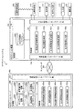
As shown in FIG. 1, the navigation system of the first embodiment schematically includes a
図2に示すように、第1の実施形態のナビゲーションシステムにおいて、ナビゲーションサーバ200は、概略的に、制御部202と記憶部206とを少なくとも備えており、端末装置100は、位置取得部112と出力部(表示部114および音声出力部116)と入力部118と撮影部120と制御部102と記憶部106とを少なくとも備える。
As shown in FIG. 2, in the navigation system of the first embodiment, the
[ナビゲーションサーバ200の構成]
ここで、図2において、ナビゲーションサーバ200は、端末装置100から送信される端末装置100の利用者の現在位置情報に基づく端末装置100の利用者の現在位置に対応する車両通行帯情報を取得し、取得された車両通行帯情報を含む出力用情報を端末装置100に送信する等の機能を有する。ナビゲーションサーバ200は、通信制御インターフェース部204を介してネットワーク300を経由し、端末装置100と相互に通信可能に接続されており、制御部202と記憶部206とを備える。制御部202は、各種処理を行う制御手段である。通信制御インターフェース部204は、通信回線や電話回線等に接続されるアンテナやルータ等の通信装置(図示せず)に接続されるインターフェースであり、ナビゲーションサーバ200とネットワーク300との間における通信制御を行う機能を有する。すなわち、通信制御インターフェース部204は、端末装置100等と通信回線を介してデータを通信する機能を有している。記憶部206は、HD(Hard Disk)等の固定ディスク装置およびSSD(Solid State Drive)等のストレージ手段であり、各種のデータベースやテーブル(ネットワーク情報データベース206a、車両通行帯情報データベース206b、地図情報データベース206c、および、案内情報データベース206d等)を格納する。
[Configuration of Navigation Server 200]
Here, in FIG. 2, the
これら記憶部206の各構成要素のうち、ネットワーク情報データベース206aは、交通網を規定するネットワーク情報を記憶するネットワーク情報記憶手段である。ここで、ネットワーク情報データベース206aに記憶されるネットワーク情報は、道路ネットワーク情報、路線網ネットワーク情報、および、施設内ネットワーク情報を含んでいてもよい。これらネットワーク情報は、ネットワーク情報データベース206aに予め記憶されており、ナビゲーションサーバ200の制御部202は、定期的にネットワーク300を介して最新のデータを外部機器(例えば、地図情報を提供する地図提供サーバなど)等からダウンロードしてネットワーク情報データベース206aに記憶されたネットワーク情報をアップデートしてもよい。
Among these components of the
ここで、ネットワーク情報データベース206aに記憶される道路ネットワーク情報は、道路網を規定するネットワーク情報であり、例えば、交差点等の道路網表現上の結節点であるノードのノードデータと、ノード間の道路区間であるリンクのリンクデータとの組み合わせによって表現されるネットワーク情報である。ここで、ノードデータには、ノード番号(例えば、ノードID等)、ノードの名称、緯度経度高度等の位置座標、ノード種別、接続するリンク本数、接続ノード番号、および、交差点名称等の情報を含んでいてもよい。また、リンクデータには、リンク番号(例えば、リンクID等)、開始ノードID、終了ノードID、道路の種別、国道や県道や市道等の路線番号、重用する路線情報、リンクの存在する行政区域の属性情報、リンク長(例えば、距離等)、道路供用状況、異常気象時通行規制区間、車重制限、車両高さ制限、幅員、道路幅員区分、レーン情報(例えば、車線数、専用通行帯、路線バス等優先通行帯、車両通行区分、および、進行方向別通行区分などについての車両通行帯情報等)、制限速度、高架、トンネルおよび橋等のリンク内属性、ならびに、名称等の情報を含んでいてもよい。また、道路ネットワーク情報は、利用料金データ等を含んでいてもよい。ここで、利用料金データは、自動車およびオートバイ等で移動する場合に消費する燃料料金、ならびに、高速自動車国道および自動車専用道路等の有料道路の通行料金等を表す情報等であってもよい。また、道路ネットワーク情報は、自動車、オートバイ、自転車、および、徒歩等で移動する場合の経路上に存在する施設等の緯度経度情報などの位置情報等を記憶してもよい。
Here, the road network information stored in the
また、道路ネットワーク情報は、道路交通情報を含んでいてもよい。ここで、道路交通情報は、渋滞発生地点や渋滞距離や道路上の二地点間の通過時間(すなわち、旅行時間など)等の渋滞情報を含んでいてもよい。また、道路交通情報は、交通障害情報や交通規制情報等を含んでいてもよい。ここで、交通規制情報は、各種の交通規制を定義するデータであり、例えば、降水量規制、積雪・凍結規制、超波規制、風速規制、および視程規制等の異常気象時通行規制、高さ規制および重量規制等の車両通行規制、道路工事や作業、道路周辺の工事に伴う工事時規制、時間帯や車種により通行できる通行帯を規制している通行帯規制および道路の損壊等による車両通行止、交通の安全を確保するために設置されるコミュニティ・ゾーン等による一般車の進入禁止、ならびに、私有地への接続路であることによる一般車の進入禁止等の情報などを含んでもよい。これら道路交通情報は、ネットワーク情報データベース206aに予め記憶されており、ナビゲーションサーバ200の制御部202は、定期的(例えば、5分毎等)にネットワーク300を介して最新のデータを外部システム(例えば、VICS(Vehicle Information and Communication System)(登録商標)、および、ATiS(Advanced Traffic Information Service)(登録商標)、日本道路交通情報センター(JARTIC)(登録商標)など)等からダウンロードしてネットワーク情報データベース206aに記憶された道路交通情報をアップデートしてもよい。
The road network information may include road traffic information. Here, the road traffic information may include traffic jam information such as a traffic jam occurrence point, a traffic jam distance, and a transit time between two locations on the road (that is, travel time, etc.). Further, the road traffic information may include traffic obstacle information, traffic regulation information, and the like. Here, the traffic regulation information is data defining various traffic regulations.For example, traffic regulation during abnormal weather such as precipitation regulation, snow cover / freezing regulation, ultrasonic regulation, wind speed regulation, visibility regulation, etc., height Vehicle traffic regulations such as regulations and weight regulations, road construction and work, regulations during construction around roads, traffic zones that regulate traffic zones that can pass by time zone and vehicle type, and vehicle traffic due to road damage, etc. It may also include information such as a general vehicle entry prohibition by a community zone or the like installed to ensure traffic safety, and a general vehicle entry prohibition due to a connection path to private land. These road traffic information is stored in advance in the
また、ネットワーク情報データベース206aに記憶される路線網ネットワーク情報は、鉄道、飛行機、バス、および、船等の各交通機関(例えば、公共交通機関等)の路線網を規定するネットワーク情報であり、例えば、路線網表現上の結節点であるノード(例えば、交通機関の停留地点である駅、停留場、停車場、停留所、空港、港、および、ターミナル等)のノードデータと、ノード間を接続する鉄道路線、航空路線、航路、および、バス路線等のリンクのリンクデータとの組み合わせによって表現されるネットワーク情報である。ここで、鉄道とは、ルート上に設置された固定式案内路(レール、および案内軌条など)等に誘導されて走行し、旅客や貨物等を輸送する交通機関であり、例えば、電車、市電、ロープウェイ、モノレール、ケーブルカー、および、リニアモーターカー等であってもよい。また、ノードデータには、ノード番号(例えば、ノードID等)、ノードの名称(例えば、交通機関の停留地点の名称である駅名、停留場名、停車場名、停留所名、空港名、港名、および、ターミナルの名称等)、および、緯度経度高度などの位置座標等の情報を含んでいてもよい。また、リンクデータには、リンク番号(例えば、リンクID等)、開始ノードID、終了ノードID、種別、リンク長(例えば、距離等)、高架、トンネルおよび橋等のリンク内属性、ならびに、名称(例えば、路線名など)等の情報を含んでいてもよい。
The route network information stored in the
また、路線網ネットワーク情報は、交通機関の時刻表データを含んでいてもよい。ここで、時刻表データは、鉄道、飛行機、バス、および、船等の各交通機関の時刻表を表す情報である。また、時刻表データは、更に、交通機関の行先情報(例えば、最終行先情報など)、および、交通機関の種別(例えば、特急、急行、準急、快速、快速急行、通勤特急、通勤快速、通勤急行、区間急行、区間準急、区間快速、各駅停車、および、普通など)を含む情報であってもよい。また、時刻表データは、更に、路線上のノード(すなわち、交通機関の停留地点)における交通機関の発着時刻(例えば、出発、経由、および到着の予定時刻など)、交通機関の路線の名称、および、交通機関の路線上のノード(すなわち、交通機関の停留地点)の名称等の属性情報を含む情報であってもよい。また、時刻表データは、交通機関の路線上のノードを結ぶ区間(例えば、一つまたは複数のリンク等)毎に対応付けられた交通機関の属性情報(例えば、種別および行先情報等)を含んでいてもよい。 The route network information may include transportation timetable data. Here, the timetable data is information representing a timetable of each transportation facility such as a railway, an airplane, a bus, and a ship. In addition, the timetable data further includes destination information (for example, final destination information) of transportation, and type of transportation (for example, limited express, express, semi-express, rapid, rapid express, commuter express, commuter express, commute) Information including express, section express, section semi-express, section rapid, each station stop, and normal). In addition, the timetable data further includes transportation departure and arrival times (for example, scheduled departure, transit and arrival times) at nodes on the route (that is, transportation stop points), transportation route names, Information including attribute information such as the name of a node on a route of transportation (that is, a stop point of transportation) may be used. Further, the timetable data includes transportation attribute information (for example, type and destination information) associated with each section (for example, one or a plurality of links) connecting nodes on the transportation route. You may go out.
また、路線網ネットワーク情報は、交通機関の利用料金データを含んでいてもよい。ここで、利用料金データは、例えば、鉄道、飛行機、バス、および、船等の各交通機関を利用した場合に生じる利用料金等を表す情報等であってもよい。また、路線網ネットワーク情報は、乗車位置データを含んでいてもよい。ここで、乗車位置データは、例えば、電車、市電、モノレール、ケーブルカー、および、リニアモーターカー等の複数の車両が連結した交通機関の乗車位置(一例として、改札口に近い車両、乗換に便利な位置の車両、混雑率の低い車両、および、女性専用車両等)を表す情報等であってもよい。また、路線網ネットワーク情報は、鉄道運行情報、航空運行情報、船舶運行情報、および、バス運行情報等の各交通機関の運行情報を含んでいてもよい。これら各交通機関の運行情報は、ネットワーク情報データベース206aに予め記憶されており、ナビゲーションサーバ200の制御部202は、定期的にネットワーク300を介して最新のデータを外部システム等からダウンロードしてネットワーク情報データベース206aに記憶された各交通機関の運行情報をアップデートしてもよい。
The route network information may include transportation fee data. Here, the usage fee data may be, for example, information representing a usage fee or the like generated when each transportation means such as a railroad, an airplane, a bus, and a ship is used. The route network information may include boarding position data. Here, the boarding position data is, for example, a transportation boarding position where a plurality of vehicles such as trains, streetcars, monorails, cable cars, and linear motor cars are connected (for example, vehicles close to the ticket gates, convenient for transfer) Vehicle position information, low congestion rate vehicles, women-only vehicles, and the like). Further, the route network information may include operation information of each transportation such as railway operation information, air operation information, ship operation information, and bus operation information. The operation information of each of these transportation facilities is stored in advance in the
また、ネットワーク情報データベース206aに記憶される施設内ネットワーク情報は、施設内の経路網を規定するネットワーク情報である。ここで、ネットワーク情報データベース206aに記憶される施設内ネットワーク情報は、例えば、建造物内の店舗、会社、事務所、およびトイレ等の出入口、エレベータおよびエスカレータの乗降口、階段の出入口、飛行機等の搭乗口、駅のプラットホーム上の電車等の乗車位置、ならびに、駅の改札口等の、通路等を接続する結節点であるノードのノードデータと、ノード間を接続する通路、階段、動く歩道、エスカレータ、および、エレベータ等であるリンクのリンクデータとの組み合わせによって表現されるネットワーク情報である。
The in-facility network information stored in the
ここで、ノードデータには、ノード番号(例えば、ノードID等)、ノードの名称(出入口名および乗降口名等)、緯度経度高度等の位置座標、ノード種別(例えば、出入口、乗降口、通路の曲がり角、および通路の分岐点等)、接続するリンク本数、および、接続ノード番号等の情報を含んでいてもよい。また、リンクデータには、リンク番号(例えば、リンクID等)、開始ノードID、終了ノードID、リンク長、幅員、リンク種別(例えば、ノード間を接続する通路、階段、スロープ、エスカレータ、エレベータ、および動く歩道など)、および、バリアフリー化の情報を含んでいてもよい。ここで、施設とは、駅、オフィスビル、ホテル、デパート、スーパーマーケット、博物館、美術館、学校、水族館、地下通路、立体駐車場、地下駐車場、および、地下街等の屋内建造物であってもよい。また、施設とは、バスターミナル、公園、遊園地、キャンプ場、連絡通路、屋外駐車場、および、動物園等の屋外建造物であってもよい。 Here, the node data includes a node number (for example, node ID, etc.), a node name (entrance / exit name, entrance / exit name, etc.), position coordinates such as latitude and longitude altitude, and node type (for example, entrance / exit / exit / exit, passage) And the like, the number of links to be connected, and the connection node number may be included. The link data includes a link number (for example, link ID, etc.), a start node ID, an end node ID, a link length, a width, a link type (for example, a passage connecting steps between nodes, a stairs, a slope, an escalator, an elevator, And a moving walkway), and information on barrier-free. Here, the facility may be an indoor building such as a station, an office building, a hotel, a department store, a supermarket, a museum, a museum, a school, an aquarium, an underground passage, a multistory parking lot, an underground parking lot, and an underground mall. . The facility may be a bus terminal, a park, an amusement park, a campsite, a communication path, an outdoor parking lot, and an outdoor structure such as a zoo.
また、車両通行帯情報データベース206bは、道路の車両通行帯に関する車両通行帯情報を記憶する車両通行帯情報記憶手段である。ここで、車両通行帯情報は、車両が走行不能または走行困難となる車両通行帯の規制情報を含んでもよい。ここで、走行不能または走行困難となる車両通行帯は、専用通行帯(例えば、路線バス専用通行帯、二輪専用通行帯、および、二輪・軽車両専用通行帯等)、または、優先通行帯(例えば、路線バス等優先通行帯など)であってもよい。また、走行不能または走行困難となる車両通行帯の規制情報は、工事、事故、または車両故障による交通規制情報であってもよい。また、車両通行帯情報は、更に、車両の車線変更に関する車両通行帯の規制情報を含んでもよい。また、車両通行帯情報は、更に、車両通行区分の規制情報を含んでもよい。また、車両通行帯情報は、更に、リンク毎の車線(レーン)数、レーン毎の進行方向、ならびに、右折専用および左折専用等の車両通行帯の規制情報を含んでいてもよい。これら車両通行帯情報は、車両通行帯情報データベース206bに予め記憶されており、ナビゲーションサーバ200の制御部202は、定期的にネットワーク300を介して最新のデータを外部システム(例えば、警察庁、VICS(登録商標)、ATiS(登録商標)、および、日本道路交通情報センター(登録商標)など)等からダウンロードして車両通行帯情報データベース206bに記憶された車両通行帯情報をアップデートしてもよい。本実施形態において、車両通行帯情報データベース206bは、地図情報データベース206cと分離した構成として示したが、地図情報データベース206cに記憶された地図情報は、車両通行帯情報データベース206bに記憶された車両通行帯情報を含んだ構成としてもよい。
The vehicle traffic
また、地図情報データベース206cは、地図の地図情報を記憶する地図情報記憶手段である。ここで、地図情報データベース206cに記憶される地図情報は、本発明において、例えば、縮尺に従ってメッシュ化された地図情報(例えば、JIS規格の第1〜3次地域区画メッシュデータ、および、100mメッシュデータ等)等の屋外地図情報であってもよい。また、地図情報データベース206cは、全国および各地方の道路地図や路線図等の屋外地図情報を記憶してもよい。また、地図情報データベース206cは、例えば、高さ情報を持つ建築物(例えば、立体駐車場、駅、デパート、および、学校等)に関するフロア案内地図等の屋内地図情報を更に記憶してもよい。
The
また、地図情報データベース206cに記憶される地図情報は、地図上に表示される地物(例えば、ビルや住宅や駅等の建造物、道路、線路、橋、トンネル、等高線、海岸線や湖岸線等の水涯線、海、河川、湖、池、沼、公園や屋外施設等の場地、行政界、行政区域、および、街区等)の形状についての形状データ、地図上に表示される注記(例えば、地名、住所、電話番号、店や公園や駅等の施設名称、名所や旧跡や河川や湖や湾や山や森林等の俗称を含む名称、道路や橋やトンネル等の名称、路線名称、地点情報、および、口コミ情報等)の注記データ、および、地図上に表示される記号(例えば、山、史跡、寺社、学校、病院、工場および墓地等の地図記号、ガソリンスタンド、コンビニエンスストア、スーパーマーケット、レストラン、銀行および郵便局等の店舗記号、道路上の信号、有料道路の出入口、料金所、サービスエリア、パーキングエリアおよびインターチェンジ等の記号、駐車場、駅、ホテル、美術館および博物館等の施設記号、ならびに、口コミ地点記号等)の記号データ等のデータを含んでいてもよい。
The map information stored in the
また、地図情報データベース206cに記憶される屋内地図情報は、施設等の構内における屋内経路についての構内経路データを含んでいてもよい。ここで、構内経路データとは、駅等の構内における移動経路データと、当該移動経路を含む地図(施設案内図)の地図情報と、に少なくとも基づくデータであってもよい。例えば、構内経路データは、施設案内図に移動経路が引いてある画像データであってもよい。また、例えば、構内経路データは、更に、移動経路を説明するメッセージデータを含んでいてもよい。ここで、移動経路データに基づく移動経路とは、施設内で複数の交通機関の乗換えをする場合の改札口等を結ぶ最適経路(例えば、最短経路またはバリアフリー経路等)であってもよい。
Moreover, the indoor map information stored in the
また、屋外地図情報および屋内地図情報は、ラスタ形式およびベクタ形式等の地図描画用の画像データであってもよい。これら屋外地図情報および屋内地図情報は、地図情報データベース206cに予め記憶されており、ナビゲーションサーバ200の制御部202は、定期的にネットワーク300を介して最新のデータを外部機器(例えば、地図情報を提供する地図提供サーバなど)等からダウンロードして地図情報データベース206cに記憶された屋外地図情報および屋内地図情報をアップデートしてもよい。
The outdoor map information and the indoor map information may be image data for map drawing in a raster format or a vector format. These outdoor map information and indoor map information are stored in advance in the
また、案内情報データベース206dは、案内情報(音声案内情報および表示案内情報等)を記憶する案内情報記憶手段である。ここで、案内情報データベース206dに記憶された表示案内情報は、分岐点等における進行方向等に対応付けられた、右左折等の誘導を画面に表示する矢印ナビゲーションであるターンバイターン(TBT)、および、現在位置が目標物に近づいた旨を知らせる文字データ等であってもよく、例えば、端末装置100の制御部102が表示案内を実行する際に用いられてもよい。また、案内情報データベース206dに記憶された音声案内情報は、現在位置周辺に渋滞している領域があることを知らせる音声データであってもよく、走行位置に基づく警告に対応付けられた「路線バス専用通行帯を走行しています」、「二輪車専用通行帯を走行しています」、「路線バス等優先通行帯を走行しています」、「走行レーンは事故(または、工事等)によりこの先走行できません」、および、「走行レーンはこの先高速道路へ接続します」、渋滞箇所の案内に対応付けられた「この先渋滞しています」、分岐点等における進行方向等に対応付けられた「次の交差点を左に曲がります」、ならびに、現在位置が目的地に近づいた場合に対応付けられた「まもなく目的地周辺です」等の音声データであってもよく、例えば、端末装置100の制御部102が音声案内を実行する際に用いられてもよい。
The
また、制御部202は、OS(Operating System)等の制御プログラムや、各種の処理手順等を規定したプログラム、および、所要データを格納するための内部メモリを有する。そして、制御部202は、これらのプログラム等により、種々の処理を実行するための情報処理を行う。制御部202は、機能概念的に、出力用情報要求受信部202a、地図情報取得部202b、車両通行帯情報取得部202c、出力用情報生成部202d、および、出力用情報送信部202eを備える。
The
このうち、出力用情報要求受信部202aは、端末装置100から送信される、出力用情報要求を受信する出力用情報要求受信手段である。ここで、出力用情報要求は、端末装置100の利用者の現在位置情報を含んでいてもよい。また、出力用情報要求は、端末装置100の制御部102により取得された道路の車両通行帯を特定する特定情報を含んでいてもよい。また、出力用情報要求は、端末装置100の撮影部120にて撮影された画像を含んでいてもよい。また、出力用情報要求は、端末装置100の利用者により端末装置100の入力部118を介して入力されたものであってもよい。
Among these, the output information
また、地図情報取得部202bは、地図の地図情報を地図情報データベース206cから取得する地図情報取得手段である。ここで、地図情報取得部202bは、端末装置100の利用者の現在位置を含む地図の地図情報を地図情報データベース206cから取得してもよい。
The map
また、車両通行帯情報取得部202cは、端末装置100の利用者の現在位置に対応する車両通行帯情報を車両通行帯情報データベース206bから取得する車両通行帯情報取得手段である。ここで、車両通行帯情報取得部202cは、更に、端末装置100の利用者の現在位置近傍の道路の車両通行帯情報を車両通行帯情報データベース206bから取得してもよい。また、車両通行帯情報取得部202cは、道路の車両通行帯を特定する特定情報に基づき、端末装置100の利用者の現在位置に対応する車両通行帯情報を車両通行帯情報データベース206bから取得してもよい。また、車両通行帯情報は、車両の車線変更に関する車両通行帯の規制情報を含んでもよい。また、車両通行帯情報は、車両通行区分の規制情報を含んでもよい。
The vehicle traffic zone
また、出力用情報生成部202dは、車両通行帯情報取得部202cにより取得された車両通行帯情報を含む出力用情報を生成する出力用情報生成手段である。ここで、出力用情報は、更に、地図情報データベース206cに記憶された、端末装置100の利用者の現在位置を含む地図の地図情報を含んでもよい。また、出力用情報は、更に、警告通知を含んでもよい。ここで、警告通知は、メッセージ通知を行うための文字情報であってもよく、音声通知を行う音声案内情報であってもよい。また、出力用情報生成部202dは、更に、案内情報データベース206dに記憶された案内情報(分岐点等において出力されるTBT等の表示案内情報、および、表示に対応した音声案内情報等)を含む出力用情報を生成してもよい。
The output
また、出力用情報送信部202eは、出力用情報生成部202dにより生成された出力用情報を端末装置100に送信する出力用情報送信手段である。
The output information transmission unit 202e is output information transmission means for transmitting the output information generated by the output
[端末装置100の構成]
また、図2において、端末装置100は、ナビゲーションサーバ200から送信される出力用情報を受信し、経路案内を行っていない場合に、出力用情報を出力部を介して出力させる等の機能を有する。端末装置100は、例えば、一般に市販されるデスクトップ型またはノート型のパーソナルコンピュータ等の情報処理装置、携帯電話、スマートフォン、PHS、およびPDA等の携帯端末装置、および、走行経路案内等を行なうナビゲーション端末(例えば、カーナビゲーション装置など)等である。ここで、端末装置100は、インターネットブラウザ等を搭載していてもよく、経路案内アプリケーション、乗換案内アプリケーション、および情報検索アプリケーション等を搭載していてもよい。また、端末装置100は、リアルタイムに現在位置取得が行えるよう、GPS機能やIMES機能等を有する位置取得部112を備えている。また、端末装置100は、表示部114と音声出力部116とを少なくとも含む出力部を備えている。
[Configuration of Terminal Device 100]
In FIG. 2, the
ここで、表示部114は、アプリケーション等の表示画面を表示する表示手段(例えば、液晶または有機EL等から構成されるディスプレイおよびモニタ等)である。また、音声出力部116は、音声データを音声として出力する音声出力手段(例えば、スピーカ等)である。また、端末装置100は、検索条件の入力等を行う入力部118(例えば、キー入力部、タッチパネル、キーボード、およびマイク等)を備えている。また、端末装置100は、デジタルカメラ、フィルムカメラ、またはビデオカメラ等の、静止画または動画を記録する撮影部120を備えている。また、入出力制御インターフェース部108は、位置取得部112、表示部114、音声出力部116、入力部118、および、撮影部120等の制御を行う。
Here, the display unit 114 is a display unit (for example, a display and a monitor including a liquid crystal or an organic EL) that displays a display screen of an application or the like. The
ここで、位置取得部112は、例えば、位置発信装置500から発信される位置情報信号を受信する信号受信手段であってもよい。ここで、位置発信装置500は、位置情報信号(GPS信号)を発信するGPS装置であってもよい。また、位置発信装置500は、端末装置100との間で無線通信を行うための装置等である基地局(例えば、携帯電話、自動車電話、および、PHSの基地局等)であってもよい。また、位置発信装置500は、GPS信号と類似した特徴を持つ位置情報信号を用いて屋内測位を可能とするIMES(Indoor Message System)技術を実現するIMES装置であってもよい。なお、IMES技術は測位衛星システムである準天頂衛星の枠組みから発案されたシステムである。
Here, the
また、位置発信装置500は、屋外で受信したGPS信号を屋内で発信するGPSリピータであってもよい。また、位置発信装置500は、建物(例えば、立体駐車場等)内の各フロアや地下構造物(例えば、地下鉄駅、地下街、地下連絡通路、および地下駐車場等)の各所に任意に設置される小型発信装置であってもよい。なお、この小型発信装置には、設置場所に応じた自己位置情報(位置ID等)が割り振られている。そして、端末装置100が通信可能範囲に入ると、端末装置100は、小型発信装置から送信される自己位置情報を位置情報信号として受信する。この際の通信方式は、例えば、RFID(Radio Frequency Identification)タグシステムやBluetooth(登録商標)等の各種近距離無線方式や、赤外線通信方式等であってもよい。また、位置発信装置500は、無線LANのアクセスポイントであってもよい。本実施形態において、位置取得部112は、無線LAN信号等を受信して、アクセスポイントの識別情報を取得してもよい。そして、制御部102は、位置取得部112にて取得したアクセスポイント固有の識別情報からアクセスポイントの位置を特定して位置情報を取得してもよい。また、本実施形態において、制御部102は、位置取得部112にて取得された位置情報信号から、緯度、経度、および、高さ情報を含む位置情報を算出してもよい。
Further, the
また、位置取得部112は、例えば、方位センサにて検出した端末装置100の進行方向等の方位情報、距離センサにて検出した距離情報、および、地図情報に基づいて端末装置100の利用者の現在位置を示す位置情報を取得してもよい。ここで、方位センサには、端末装置100の絶対走行方位を検出する地磁気センサおよび端末装置100の相対走行方位を検出する光ジャイロ等が使用されてもよい。また、方位センサは、地磁気センサと加速度センサを組み合わせることで方位や傾きに関する情報を取得できる電子コンパス等であってもよい。また、距離センサは、端末装置100が車載の情報処理端末である場合、車軸の回転数に比例してパルス信号を発生させ、パルス信号の数量に比例した移動距離を検出してもよい。また、位置取得部112は、端末装置100が車載の情報処理端末である場合、各車両に搭載された通信装置の車車間通信から自車位置を示す位置情報を取得してもよい。
Further, the
また、通信制御インターフェース部104は、通信回線や電話回線等に接続されるアンテナやルータ等の通信装置(図示せず)に接続されるインターフェースであり、端末装置100とネットワーク300との間における通信制御を行う機能を有する。すなわち、通信制御インターフェース部104は、ナビゲーションサーバ200等と通信回線を介してデータを通信する機能を有している。また、ネットワーク300は、端末装置100およびナビゲーションサーバ200と、外部の地図提供サーバ等の外部機器または外部システムとを相互に接続する機能を有し、例えば、インターネット、電話回線網(携帯端末回線網および一般電話回線網等)、イントラネット、または、電力線通信(PLC)等であってもよい。
The communication
また、記憶部106は、HDやSSD等の大容量のストレージ手段、および/または、SRAM(Static Random Access Memory)等を用いて構成される小容量高速メモリ(例えば、キャッシュメモリ)等のストレージ手段であり、各種のデータベースやファイルやテーブル(出力用情報ファイル106a等)を格納してもよい。ここで、記憶部106は、各種のファイル等を一時的に記憶するものであってもよい。
The
このうち、出力用情報ファイル106aは、出力用情報を記憶する出力用情報記憶手段である。
Among these, the
また、制御部102は、OS等の制御プログラムや、各種の処理手順等を規定したプログラム、および、所要データを格納するための内部メモリを有する。そして、制御部102は、これらのプログラム等により、種々の処理を実行するための情報処理を行う。制御部102は、機能概念的に、現在位置情報取得部102a、特定情報取得部102b、出力用情報要求送信部102c、出力用情報受信部102d、および、出力用情報出力部102eを備える。
The
ここで、現在位置情報取得部102aは、端末装置100の利用者の現在位置情報を取得する現在位置情報取得手段である。ここで、現在位置情報取得部102aは、端末装置100の利用者の現在位置情報を所定時間(所定周期)ごと(例えば、1秒ごと、または、3分ごと等)に取得してもよい。また、現在位置情報取得部102aは、位置取得部112にて位置発信装置500から受信した位置情報信号から算出した位置情報を端末装置100の利用者の現在位置情報として取得してもよい。また、現在位置情報取得部102aは、更に、位置取得部112の方位センサ等にて検出した端末装置100の進行方向等の方位情報を端末装置100の利用者の現在位置情報として取得してもよい。
Here, the current position information acquisition unit 102a is a current position information acquisition unit that acquires the current position information of the user of the
また、現在位置情報取得部102aは、利用者により入力部118を介して入力された現在位置についての位置座標等の位置情報を端末装置100の利用者の現在位置情報として取得してもよい。ここで、利用者により入力部118を介して入力された現在位置情報に基づく現在位置は、利用者が現実に存在する位置であってもよく、利用者により任意に選択された仮想の現在位置(一例として、東京にいる利用者により選択された大阪の駅や空港等の任意の地点)であってもよい。例えば、現在位置情報取得部102aは、入力部118を介して利用者に表示部114に表示された地図情報の表示画面上で指定(例えば、タッチパネル式の表示部114での指定操作等)させた座標を端末装置100の利用者の現在位置情報として取得してもよい。また、現在位置情報取得部102aは、更に、入力部118を介して利用者に表示部114に表示された地図情報の表示画面上で指定させた方位情報を端末装置100の利用者の現在位置情報として取得してもよい。
Further, the current position information acquisition unit 102a may acquire position information such as position coordinates about the current position input by the user via the
また、特定情報取得部102bは、撮影部120にて撮影された画像に基づき車両通行帯を特定する特定情報を取得する特定情報取得手段(走行区分検出手段)である。
The specific
また、出力用情報要求送信部102cは、出力用情報要求を送信する出力用情報要求送信手段である。
The output information
また、出力用情報受信部102dは、ナビゲーションサーバ200から送信される出力用情報を受信する出力用情報受信手段である。ここで、出力用情報受信部102dは、更に、受信した出力用情報を出力用情報ファイル106aに格納してもよい。ここで、出力用情報受信部102dは、出力用情報ファイル106aに既存の出力用情報が記憶されている場合、新たに設定された出力用情報を、既存の出力用情報に上書きして格納してもよい。
The output
また、出力用情報出力部102eは、出力用情報を出力部を介して出力させる出力用情報出力手段である。ここで、出力用情報出力部102eは、経路案内を行っていない場合に、出力用情報を出力部を介して出力させてもよい。また、出力用情報出力部102eは、経路案内を行っていない場合であり、端末装置100の利用者の現在位置が車線変更可能な車両通行帯にある場合に、車両の車線変更に関する車両通行帯の規制情報を含む車両通行帯情報を含む出力用情報を出力部を介して出力させてもよい。また、出力用情報出力部102eは、経路案内を行っていない場合に、端末装置100の利用者により設定された車種に応じた車両通行区分の規制情報を含む車両通行帯情報を含む出力用情報を出力部を介して出力させてもよい。また、出力用情報出力部102eは、経路案内を行っていない場合に、出力用情報に基づく表示画面を表示部114に表示させてもよい。例えば、出力用情報出力部102eは、車両通行帯情報を含む出力用情報に基づく表示画面を表示部114に表示させてもよい。また、出力用情報出力部102eは、更に、出力用情報に含まれる、端末装置100の利用者の現在位置を含む地図の地図情報、および/または、警告通知に基づく表示画面を表示部114に表示させてもよい。
The output
また、出力用情報出力部102eは、更に、出力用情報に含まれる案内情報に含まれるTBT等の表示案内情報に基づく表示画面を表示部114に表示させてもよい。また、出力用情報出力部102eは、更に、端末装置100の利用者の現在位置情報を出力部を介して出力させてもよい。例えば、出力用情報出力部102eは、出力用情報に含まれる地図情報上に、出力用情報に含まれる車両通行帯情報、出力用情報に含まれる警告通知、および/または、端末装置100の利用者の現在位置情報、を重畳した表示画面を表示部114に表示させてもよい。また、出力用情報出力部102eは、出力用情報を音声出力部116を介して出力させてもよい。例えば、出力用情報出力部102eは、出力用情報に含まれる走行位置に基づく警告に対応付けられた音声案内情報を、音声出力部116を介して出力させてもよい。
Further, the output
以上で、第1の実施形態におけるナビゲーションシステムの構成の一例の説明を終える。 Above, description of an example of a structure of the navigation system in 1st Embodiment is finished.
[ナビゲーションシステムの処理]
次に、このように構成された第1の実施形態におけるナビゲーションシステムの処理の一例について、以下に図3から図7を参照して詳細に説明する。図3は、第1の実施形態におけるナビゲーションシステムの処理の一例を示すフローチャートである。
[Navigation system processing]
Next, an example of the processing of the navigation system according to the first embodiment configured as described above will be described in detail with reference to FIGS. FIG. 3 is a flowchart illustrating an example of processing of the navigation system according to the first embodiment.
図3を参照して、第1の実施形態におけるナビゲーションシステムの処理の一例について説明する。 With reference to FIG. 3, an example of the process of the navigation system in the first embodiment will be described.
図3に示すように、まず、端末装置100の出力用情報要求送信部102cは、現在位置情報取得部102aにより取得された端末装置100の利用者の現在位置情報を含む、当該利用者により入力部118を介して入力された出力用情報要求(例えば、地図情報取得要求等)をナビゲーションサーバ200に送信する(ステップSA−1)。ここで、出力用情報要求は、現在位置情報取得部102aにより取得される端末装置100の利用者の現在位置情報の測位精度が悪い場合等、更に、撮影部120にて撮影された画像に基づき、特定情報取得部102bにより取得された道路の車両通行帯を特定する特定情報(例えば、通行区分が表示されている個所周辺を撮影した撮影結果を画像解析等した情報等)を含んでいてもよい。ここで、制御部102は、出力用情報要求の取得に応じて端末装置100の利用者に撮影部120にて画像を撮影させるように誘導(出力部を介した表示または音声による誘導等)してもよく、出力用情報要求の取得に応じて自動的に撮影部120にて画像を撮影させてもよい。また、制御部102は、出力用情報要求の取得に応じて現在位置情報取得部102aに端末装置100の利用者の現在位置情報を取得させてもよい。
As shown in FIG. 3, first, the output information
そして、ナビゲーションサーバ200の出力用情報要求受信部202aは、端末装置100から送信された出力用情報要求を受信する(ステップSA−2)。
Then, the output information
そして、ナビゲーションサーバ200の地図情報取得部202bは、出力用情報要求受信部202aにより受信された出力用情報要求に含まれる現在位置情報に基づく端末装置100の利用者の現在位置を含む地図(例えば、現在位置周辺の地図等)の地図情報を地図情報データベース206cから取得する(ステップSA−3)。
Then, the map
そして、ナビゲーションサーバ200の車両通行帯情報取得部202cは、出力用情報要求受信部202aにより受信された出力用情報要求に含まれる現在位置情報に基づく端末装置100の利用者の現在位置に対応する車両通行帯情報を車両通行帯情報データベース206bから取得する(ステップSA−4)。ここで、車両通行帯情報取得部202cは、更に、出力用情報要求受信部202aにより受信された出力用情報要求に含まれる現在位置情報に基づく端末装置100の利用者の現在位置近傍の道路の車両通行帯情報を車両通行帯情報データベース206bから取得してもよい。また、車両通行帯情報取得部202cは、出力用情報要求受信部202aにより受信された出力用情報要求に道路の車両通行帯を特定する特定情報が含まれている場合、更に、当該特定情報に基づき、端末装置100の利用者の現在位置に対応する車両通行帯情報を車両通行帯情報データベース206bから取得してもよい。例えば、車両通行帯情報取得部202cは、端末装置100の利用者の現在位置に基づいて走行中のレーンを特定し、当該レーンに対応する車両通行帯情報を車両通行帯情報データベース206bから取得してもよい。ここで、車両通行帯情報は、車両の車線変更に関する車両通行帯の規制情報を含んでもよい。また、車両通行帯情報は、車両通行区分の規制情報を含んでもよい。
And the vehicle traffic zone
ここで、図4および図5を参照して、本実施形態における車両通行帯情報データベース206bに記憶された車両通行帯情報の一例について説明する。図4および図5は、本実施形態における車両通行帯情報の一例を示す図である。
Here, with reference to FIG. 4 and FIG. 5, an example of the vehicle traffic zone information stored in the vehicle traffic
図4に示すように、車両通行帯情報データベース206bは、例えば、ネットワーク情報データベース206aに記憶される道路ネットワーク情報を構成するリンクデータに含まれるリンクID、当該リンクIDに対応するリンクの車両通行帯の数(レーン数)、および、当該リンクの緯度経度等の位置座標(リンク範囲情報)等から構成された車両通行帯情報(レーン情報)を記憶している。また、図5に示すように、車両通行帯情報データベース206bは、更に、図4に示すリンクIDに対応付けて(例えば、図4に示す各レーン情報の下位のレイヤに)、当該リンクIDに対応するリンクに設置された車両通行帯(レーン)のレーンID、および、当該レーンの種別(バス専用レーン、バス優先レーン、および、普通レーンなど)等から構成された車両通行帯情報(レーン情報)を記憶している。なお、レーン情報は、上記のものに限らず、リンクとレーンに関する情報(レーン種別等)が対応付けられてもよい。
As shown in FIG. 4, the vehicle traffic
図3に戻り、ナビゲーションサーバ200の出力用情報生成部202dは、車両通行帯情報取得部202cにより取得された車両通行帯情報、および、地図情報取得部202bにより取得された端末装置100の利用者の現在位置を含む地図の地図情報を含む出力用情報を生成する(ステップSA−5)。ここで、出力用情報は、更に、警告通知(例えば、メッセージ通知を行うための文字情報、および、音声通知を行う音声案内情報等)を含んでもよい。また、出力用情報生成部202dは、更に、案内情報データベース206dに記憶された案内情報(分岐点等において出力されるTBT等の表示案内情報、および、表示に対応した音声案内情報等)を含む出力用情報を生成してもよい。
Returning to FIG. 3, the output
そして、ナビゲーションサーバ200の出力用情報送信部202eは、出力用情報生成部202dにより生成された出力用情報を端末装置100に送信する(ステップSA−6)。
Then, the output information transmitting unit 202e of the
そして、端末装置100の出力用情報受信部102dは、ナビゲーションサーバ200から送信される出力用情報を受信し、受信した出力用情報を出力用情報ファイル106aに格納する(ステップSA−7)。
Then, the output
そして、端末装置100の出力用情報出力部102eは、経路案内を行っていない場合に、出力用情報ファイル106aに記憶された出力用情報に含まれる地図情報上に、出力用情報ファイル106aに記憶された出力用情報に含まれる車両通行帯情報、および、現在位置情報取得部102aにより取得された端末装置100の利用者の現在位置情報、を重畳した表示画面を表示部114に表示させ(ステップSA−8)、処理を終了する。ここで、出力用情報出力部102eは、更に、現在位置情報取得部102aにより取得された現在位置情報に基づく端末装置100の利用者の現在位置に対応する車両通行帯情報に基づく車両通行帯が走行不能または走行困難(例えば、専用通行帯、路線バス等優先通行帯、または、工事、事故、または車両故障等による交通規制中等)である場合、出力用情報ファイル106aに記憶された出力用情報に含まれる警告通知(例えば、メッセージ通知を行うための文字情報等)に基づく表示画面を表示部114に表示させてもよい。また、出力用情報出力部102eは、経路案内を行っていない場合であり、現在位置情報取得部102aにより取得された端末装置100の利用者の現在位置が車線変更可能な車両通行帯にある場合に、出力用情報ファイル106aに記憶された、車両の車線変更に関する車両通行帯の規制情報を含む車両通行帯情報を含む出力用情報に基づく表示画面を表示部114に表示させてもよい。また、出力用情報出力部102eは、経路案内を行っていない場合に、出力用情報ファイル106aに記憶された、端末装置100の利用者により設定された車種(例えば、大型自動車、中型自動車、普通自動車、軽自動車、大型特殊自動車、自動二輪車、小型特殊自動車、および、軽車両等の車種区分)に応じた車両通行区分の規制情報を含む車両通行帯情報(例えば、車種に応じたレーン情報等)を含む出力用情報に基づく表示画面を表示部114に表示させてもよい。
The output
また、例えば、出力用情報出力部102eは、ユーザが現在走行しているレーンの先が高速道路へ接続している場合に、「走行レーンはこの先高速道路へ接続します」等の警告通知(文字情報)に基づく表示画面を表示部114に表示させてもよい。また、出力用情報出力部102eは、更に、出力用情報ファイル106aに記憶された出力用情報に含まれる分岐点等において出力されるTBT等の表示案内情報に基づく表示画面を表示部114に表示させてもよい。また、出力用情報出力部102eは、更に、出力用情報ファイル106aに記憶された出力用情報に含まれる警告通知(音声通知を行う音声案内情報等)、および、表示に対応した音声案内情報等を音声出力部116を介して出力させてもよい。
In addition, for example, the output
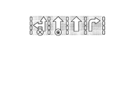
ここで、図6および図7を参照して、本実施形態におけるレーン情報表示の一例について説明する。図6および図7は、本実施形態における表示画面の一例を示す図である。 Here, an example of lane information display in the present embodiment will be described with reference to FIGS. 6 and 7. 6 and 7 are diagrams illustrating an example of a display screen in the present embodiment.
図6に示すように、出力用情報出力部102eは、経路案内を行っていない場合に、ユーザが走行している道路に専用レーンおよび優先レーンがある場合、各レーンが専用レーンまたは優先レーンであることを示す車両通行帯情報に基づく表示画面を表示部114に表示させている。具体的には、出力用情報出力部102eは、経路案内を行っていない場合に、ユーザが走行している道路の第一通行帯(最も左側のレーン)が専用通行帯であり、直進および左折用の進行方向別通行区分が設定されたレーンであることを示し、第二通行帯(中央左側のレーン)が優先通行帯であり、直進用の進行方向別通行区分が設定されたレーンであることを示し、第三通行帯(中央右側のレーン)が直進用の進行方向別通行区分が設定されたレーンであることを示し、第四通行帯(最も右側のレーン)が右折用の進行方向別通行区分が設定されたレーンであることを示す車両通行帯情報に基づく、文字アイコン(「専用」および「優先」)および矢印アイコンを表示した表示画面を表示部114に表示させている。
As shown in FIG. 6, the output
また、図7に示すように、出力用情報出力部102eは、経路案内を行っていない場合に、ユーザが走行している道路の第一通行帯が通行困難であり、直進および左折用の進行方向別通行区分が設定されたレーンであることを示し、第二通行帯が優先通行帯であり、直進用の進行方向別通行区分が設定されたレーンであることを示し、第三通行帯が直進用の進行方向別通行区分が設定されたレーンであることを示し、第四通行帯が右折用の進行方向別通行区分が設定されたレーンであることを示す車両通行帯情報に基づく、シンボルマークアイコン(「×」および「優」)および矢印アイコンを表示した表示画面を表示部114に表示させている。なお、上述の実施例では、現在走行しているレーン及び隣接しているレーンの情報を提示する場合について述べたが、出力用情報出力部102eは、本実施形態において、走行しているレーンのみの車両通行帯情報に基づく表示画面を表示部114に表示させてもよい。
In addition, as shown in FIG. 7, the output
以上で、第1の実施形態におけるナビゲーションシステムの処理の一例の説明を終える。 Above, description of an example of the process of the navigation system in 1st Embodiment is finished.
[第2の実施形態]
続いて、本発明の第2の実施形態(ナビゲーションサーバ200(サーバ主導型))について、図8および図9を参照して以下に説明する。ここで、図8は、第2の実施形態におけるナビゲーションサーバ200の構成の一例を示すブロック図であり、該構成のうち本発明に関係する部分のみを概念的に示している。また、図9は、第2の実施形態におけるナビゲーションサーバ200の処理の一例を示すフローチャートである。
[Second Embodiment]
Next, a second embodiment (navigation server 200 (server-driven type)) of the present invention will be described below with reference to FIGS. Here, FIG. 8 is a block diagram showing an example of the configuration of the
なお、第2の実施形態においては、ナビゲーションサーバ200にて端末装置100の表示部114に表示させるデータを生成し、これらのデータを端末装置100へ送信することにより、当該端末装置100の表示部114を機能させている。このように、第2の実施形態は、ナビゲーションサーバ200にてサーバ主導で処理を行う点がその他の実施形態と異なる。
In the second embodiment, the
[ナビゲーションサーバ200(サーバ主導型)の構成]
まず、第2の実施形態におけるナビゲーションサーバ200(サーバ主導型)の構成の一例について、図8を参照して以下に説明する。
[Configuration of the navigation server 200 (server-driven type)]
First, an example of the configuration of the navigation server 200 (server-driven type) in the second embodiment will be described below with reference to FIG.
図8に示すように、本発明の第2の実施形態のナビゲーションサーバ200は、位置取得部112と出力部(表示部114および音声出力部116)と入力部118と撮影部120と制御部102とを少なくとも備えた端末装置100に通信可能に接続され、制御部202と記憶部206とを少なくとも備える。通信には、一例として、ネットワーク300を介した有線・無線通信等の遠隔通信等を含む。また、これらナビゲーションサーバ200および端末装置100の各部は任意の通信路を介して通信可能に接続されている。
As illustrated in FIG. 8, the
図8において、ナビゲーションサーバ200は、端末装置100の利用者の現在位置情報を取得し、取得された現在位置情報に基づく端末装置100の利用者の現在位置に対応する車両通行帯情報を記憶部206から取得し、取得された車両通行帯情報を含む出力用情報に基づく表示画面を生成し、経路案内を行っていない場合に、表示画面を含む出力制御情報を端末装置100へ送信することにより、当該端末装置100の出力部を介して当該出力制御情報を出力させる等の機能を有する。
In FIG. 8, the
なお、ナビゲーションサーバ200における通信制御インターフェース部204および記憶部206(ネットワーク情報データベース206a、車両通行帯情報データベース206b、地図情報データベース206c、および、案内情報データベース206d等)の機能、また、端末装置100における位置取得部112、表示部114、音声出力部116、入力部118、および、撮影部120の機能は、第1の実施形態と同様であるため説明を省略する。
The functions of the communication
また、図8において、制御部202は、OS等の制御プログラムや、各種の処理手順等を規定したプログラム、および、所要データを格納するための内部メモリを有する。そして、制御部202は、これらのプログラム等により、種々の処理を実行するための情報処理を行う。制御部202は、機能概念的に、出力用情報要求受信部202a、地図情報取得部202b、車両通行帯情報取得部202c、出力用情報生成部202d、現在位置情報取得部202f、特定情報取得部202g、表示画面生成部202h、および、出力制御部202iを備える。なお、出力用情報要求受信部202a、地図情報取得部202b、車両通行帯情報取得部202c、および、出力用情報生成部202dの機能は、第1の実施形態と同様であるため説明を省略する。
In FIG. 8, the
このうち、現在位置情報取得部202fは、端末装置100の利用者の現在位置情報を取得する現在位置情報取得手段である。ここで、現在位置情報取得部202fは、端末装置100の位置取得部112にて位置発信装置500から受信した位置情報信号を端末装置100から受信し、当該位置情報信号から算出した位置情報を端末装置100の利用者の現在位置情報として取得してもよい。また、現在位置情報取得部202fは、利用者により端末装置100の入力部118を介して入力された現在位置についての位置座標等の位置情報を受信し、当該位置情報を端末装置100の利用者の現在位置情報として取得してもよい。
Among these, the current position
また、特定情報取得部202gは、端末装置100の撮影部120にて撮影された画像に基づき車両通行帯を特定する特定情報を取得する特定情報取得手段である。
Further, the specific
また、表示画面生成部202hは、出力用情報に基づく表示画面を生成する表示画面生成手段である。ここで、表示画面生成部202hは、車両通行帯情報を含む出力用情報に基づく表示画面を生成してもよい。また、表示画面生成部202hは、車両の車線変更に関する車両通行帯の規制情報を含む車両通行帯情報を含む出力用情報に基づく表示画面を生成してもよい。また、表示画面生成部202hは、端末装置100の利用者により設定された車種に応じた車両通行区分の規制情報を含む車両通行帯情報を含む出力用情報に基づく表示画面を生成してもよい。また、表示画面生成部202hは、更に、出力用情報に含まれる、端末装置100の利用者の現在位置を含む地図の地図情報、および/または、警告通知に基づく表示画面を生成してもよい。また、表示画面生成部202hは、更に、出力用情報に含まれる案内情報に含まれるTBT等の表示案内情報に基づく表示画面を生成してもよい。また、表示画面生成部202hは、更に、端末装置100の利用者の現在位置情報に基づく表示画面を生成してもよい。例えば、表示画面生成部202hは、出力用情報に含まれる地図情報上に、出力用情報に含まれる車両通行帯情報、出力用情報に含まれる警告通知、および/または、端末装置100の利用者の現在位置情報、を重畳した表示画面を生成してもよい。
The display
また、出力制御部202iは、表示画面を含む出力制御情報を端末装置100へ送信することにより、当該端末装置100の出力部を介して当該出力制御情報を出力させる出力制御手段である。ここで、出力制御部202iは、経路案内を行っていない場合に、表示画面を含む出力制御情報を端末装置100へ送信することにより、当該端末装置100の出力部を介して当該出力制御情報を出力させてもよい。また、出力制御部202iは、経路案内を行っていない場合であり、端末装置100の利用者の現在位置が車線変更可能な車両通行帯にある場合に、車両の車線変更に関する車両通行帯の規制情報を含む車両通行帯情報を含む出力用情報に基づく表示画面を含む出力制御情報を端末装置100へ送信することにより、当該端末装置100の出力部を介して当該出力制御情報を出力させてもよい。また、出力制御部202iは、経路案内を行っていない場合に、端末装置100の利用者により設定された車種に応じた車両通行区分の規制情報を含む車両通行帯情報を含む出力用情報に基づく表示画面を含む出力制御情報を端末装置100へ送信することにより、当該端末装置100の出力部を介して当該出力制御情報を出力させてもよい。また、出力制御部202iは、経路案内を行っていない場合に、表示画面を含む出力制御情報を端末装置100へ送信することにより、当該端末装置100の表示部114に当該表示画面を表示させてもよい。また、出力制御部202iは、更に、出力用情報に含まれる、表示画面に対応した音声データ(例えば、走行位置に基づく警告に対応付けられた音声案内情報等)を含む出力制御情報を端末装置100へ送信することにより、端末装置100の音声出力部116を介して出力させてもよい。
The output control unit 202 i is output control means for outputting the output control information via the output unit of the
以上で、第2の実施形態におけるナビゲーションサーバ200の構成の一例の説明を終える。
Above, description of an example of a structure of the
[ナビゲーションサーバ200(サーバ主導型)の処理]
次に、このように構成された第2の実施形態におけるナビゲーションサーバ200の処理の一例について、以下に図9を参照して詳細に説明する。
[Processing of navigation server 200 (server-driven type)]
Next, an example of processing of the
図9を参照して、第2の実施形態におけるナビゲーションサーバ200の処理の一例について説明する。
With reference to FIG. 9, an example of processing of the
図9に示すように、まず、端末装置100の制御部102は、位置取得部112にて位置発信装置500から受信した位置情報信号を含む、当該利用者により入力部118を介して入力された出力用情報要求をナビゲーションサーバ200に送信する(ステップSB−1)。ここで、出力用情報要求は、ナビゲーションサーバ200の現在位置情報取得部202fにより取得される端末装置100の利用者の現在位置情報の測位精度が悪い場合等、更に、撮影部120にて撮影された画像を含んでいてもよい。ここで、ナビゲーションサーバ200の制御部202は、出力用情報要求の取得に応じて端末装置100の利用者に撮影部120にて画像を撮影させるように誘導してもよく、出力用情報要求の取得に応じて自動的に端末装置100の撮影部120にて画像を撮影するように制御してもよい。また、ナビゲーションサーバ200の制御部202は、出力用情報要求の取得に応じて端末装置100の位置取得部112にて位置発信装置500から位置情報信号を受信するように制御してもよい。
As shown in FIG. 9, first, the
そして、ナビゲーションサーバ200の出力用情報要求受信部202aは、端末装置100から送信された出力用情報要求を受信する。そして、現在位置情報取得部202fは、出力用情報要求受信部202aにより受信された出力用情報要求に含まれる位置情報信号から位置情報を算出し、当該位置情報を端末装置100の利用者の現在位置情報として取得する(ステップSB−2)。ここで、特定情報取得部202gは、出力用情報要求受信部202aにより受信された出力用情報要求に端末装置100の撮影部120にて撮影された画像が含まれる場合、当該画像に基づき車両通行帯を特定する特定情報を取得してもよい。
Then, the output information
そして、ナビゲーションサーバ200の地図情報取得部202bは、現在位置情報取得部202fにより取得された現在位置情報に基づく端末装置100の利用者の現在位置を含む地図(例えば、現在位置周辺の地図等)の地図情報を地図情報データベース206cから取得する(ステップSB−3)。
Then, the map
そして、ナビゲーションサーバ200の車両通行帯情報取得部202cは、現在位置情報取得部202fにより取得された現在位置情報に基づく端末装置100の利用者の現在位置に対応する車両通行帯情報を車両通行帯情報データベース206bから取得する(ステップSB−4)。ここで、車両通行帯情報取得部202cは、更に、現在位置情報取得部202fにより取得された現在位置情報に基づく端末装置100の利用者の現在位置近傍の道路の車両通行帯情報を車両通行帯情報データベース206bから取得してもよい。また、車両通行帯情報取得部202cは、出力用情報要求受信部202aにより受信された出力用情報要求に端末装置100の撮影部120にて撮影された画像が含まれている場合、更に、特定情報取得部202gにより取得された道路の車両通行帯を特定する特定情報に基づき、端末装置100の利用者の現在位置に対応する車両通行帯情報を車両通行帯情報データベース206bから取得してもよい。ここで、車両通行帯情報は、車両の車線変更に関する車両通行帯の規制情報を含んでもよい。また、車両通行帯情報は、車両通行区分の規制情報を含んでもよい。
Then, the vehicle traffic zone
ここで、第2の実施形態におけるステップSB−5の処理は、図3に示す第1の実施形態におけるステップSA−5の処理と同様であるため説明を省略する。 Here, the process of step SB-5 in the second embodiment is the same as the process of step SA-5 in the first embodiment shown in FIG.
そして、ナビゲーションサーバ200の表示画面生成部202hは、出力用情報生成部202dにより生成された出力用情報に含まれる地図情報上に、出力用情報生成部202dにより生成された出力用情報に含まれる車両通行帯情報、および、現在位置情報取得部202fにより取得された端末装置100の利用者の現在位置情報、を重畳した表示画面を生成する(ステップSB−6)。ここで、表示画面生成部202hは、出力用情報生成部202dにより生成された、車両の車線変更に関する車両通行帯の規制情報を含む車両通行帯情報を含む出力用情報に基づく表示画面を生成してもよい。また、表示画面生成部202hは、出力用情報生成部202dにより生成された、端末装置100の利用者により設定された車種に応じた車両通行区分の規制情報を含む車両通行帯情報を含む出力用情報に基づく表示画面を生成してもよい。また、表示画面生成部202hは、更に、出力用情報生成部202dにより生成された出力用情報に含まれる、現在位置情報取得部202fにより取得された端末装置100の利用者の現在位置を含む地図の地図情報、および/または、警告通知に基づく表示画面を生成してもよい。また、表示画面生成部202hは、更に、出力用情報生成部202dにより生成された出力用情報に含まれる案内情報に含まれるTBT等の表示案内情報に基づく表示画面を生成してもよい。
The display
そして、ナビゲーションサーバ200の出力制御部202iは、経路案内を行っていない場合に、表示画面生成部202hにより生成された表示画面を含む出力制御情報を端末装置100へ送信することにより、当該端末装置100の表示部114に当該表示画面を表示させ(ステップSB−7)、処理を終了する。ここで、出力制御部202iは、経路案内を行っていない場合であり、現在位置情報取得部202fにより取得された現在位置情報に基づく端末装置100の利用者の現在位置が車線変更可能な車両通行帯にある場合に、表示画面生成部202hにより生成された、車両の車線変更に関する車両通行帯の規制情報を含む車両通行帯情報を含む出力用情報に基づく表示画面を含む出力制御情報を端末装置100へ送信することにより、当該端末装置100の出力部を介して当該出力制御情報を出力させてもよい。また、出力制御部202iは、経路案内を行っていない場合に、表示画面生成部202hにより生成された、端末装置100の利用者により設定された車種に応じた車両通行区分の規制情報を含む車両通行帯情報を含む出力用情報に基づく表示画面を含む出力制御情報を端末装置100へ送信することにより、当該端末装置100の出力部を介して当該出力制御情報を出力させてもよい。また、出力制御部202iは、更に、出力用情報生成部202dにより生成された出力用情報に含まれる、表示画面に対応した音声データを含む出力制御情報を端末装置100へ送信することにより、端末装置100の音声出力部116を介して出力させてもよい。
Then, the output control unit 202i of the
以上で、第2の実施形態におけるナビゲーションサーバ200の処理の一例の説明を終える。
Above, description of an example of the process of the
[第3の実施形態]
続いて、本発明の第3の実施形態(ナビゲーション装置400(スタンドアローン型))について、図10および図11を参照して以下に説明する。ここで、図10は、第3の実施形態におけるナビゲーション装置400の構成の一例を示すブロック図であり、該構成のうち本発明に関係する部分のみを概念的に示している。また、図11は、第3の実施形態におけるナビゲーション装置400の処理の一例を示すフローチャートである。
[Third Embodiment]
Next, a third embodiment (navigation device 400 (stand-alone type)) of the present invention will be described below with reference to FIGS. 10 and 11. Here, FIG. 10 is a block diagram showing an example of the configuration of the
なお、第3の実施形態においては、全ての機能をナビゲーション装置400に集約し、ナビゲーションサーバ200に接続することなく、ナビゲーション装置400の利用者の現在位置情報を取得し、取得された現在位置情報に基づくナビゲーション装置400の利用者の現在位置に対応する車両通行帯情報を記憶部406から取得し、経路案内を行っていない場合に、取得された車両通行帯情報を含む出力用情報を出力部を介して出力させる等の機能を有する。このように、第3の実施形態は、ナビゲーション装置400がスタンドアローン型に構成され単独で処理を行う点がその他の実施形態と異なる。
Note that in the third embodiment, all functions are aggregated in the
[ナビゲーション装置400(スタンドアローン型)の構成]
まず、第3の実施形態におけるナビゲーション装置400(スタンドアローン型)の構成の一例について、図10を参照して以下に説明する。
[Configuration of the navigation device 400 (stand-alone type)]
First, an example of the configuration of the navigation device 400 (stand-alone type) in the third embodiment will be described below with reference to FIG.
図10に示すように、本発明の第3の実施形態のナビゲーション装置400は、位置取得部412と出力部(表示部414および音声出力部416)と入力部418と制御部402と記憶部406とを少なくとも備える。これらナビゲーション装置400の各部は任意の通信路を介して通信可能に接続されてもよい。ナビゲーション装置400は、例えば、PND(Portable Navigation Device)等の各種ナビゲーション端末、ノート型のパーソナルコンピュータ等の各種情報処理装置、または、携帯電話やPHSやPDA等の携帯端末装置等であってもよい。
As illustrated in FIG. 10, the
図10において、入出力制御インターフェース部408、位置取得部412、表示部414、音声出力部416、入力部418、および、撮影部120の各機能は、第1の実施形態と同様であるため説明を省略する。また、記憶部406の各部(ネットワーク情報データベース406a、車両通行帯情報データベース406b、地図情報データベース406c、および、案内情報データベース406d等)についても、ナビゲーションサーバ200ではなくナビゲーション装置400に備えられている点を除き、各機能が第1の実施形態と同様であるため説明を省略する。
In FIG. 10, the functions of the input / output
また、制御部402の各部については、本実施形態のナビゲーション装置400がスタンドアローン型であり、制御部402が各送信部を備えていない点を除き、各機能は第1の実施形態と基本的に同様である。
As for each part of the
また、図10において、制御部402は、OS等の制御プログラムや、各種の処理手順等を規定したプログラム、および、所要データを格納するための内部メモリを有する。そして、制御部402は、これらのプログラム等により、種々の処理を実行するための情報処理を行う。制御部402は、機能概念的に、現在位置情報取得部402a、出力用情報要求取得部402b、特定情報取得部402c、地図情報取得部402d、車両通行帯情報取得部402e、出力用情報生成部402f、および、出力用情報出力部402gを備える。
In FIG. 10, the
このうち、現在位置情報取得部402aは、ナビゲーション装置400の利用者の現在位置情報を取得する現在位置情報取得手段である。ここで、現在位置情報取得部402aは、ナビゲーション装置400の利用者の現在位置情報を所定周期ごと(例えば、1秒ごと、または、3分ごと等)に取得してもよい。また、現在位置情報取得部402aは、位置取得部412にて位置発信装置500から受信した位置情報信号から算出した位置情報をナビゲーション装置400の利用者の現在位置情報として取得してもよい。また、現在位置情報取得部402aは、更に、位置取得部412の方位センサ等にて検出したナビゲーション装置400の進行方向等の方位情報をナビゲーション装置400の利用者の現在位置情報として取得してもよい。
Among these, the current position
また、現在位置情報取得部402aは、利用者により入力部418を介して入力された現在位置についての位置座標等の位置情報をナビゲーション装置400の利用者の現在位置情報として取得してもよい。ここで、利用者により入力部418を介して入力された現在位置情報に基づく現在位置は、利用者が現実に存在する位置であってもよく、利用者により任意に選択された仮想の現在位置(一例として、東京にいる利用者により選択された大阪の駅や空港等の任意の地点)であってもよい。例えば、現在位置情報取得部402aは、入力部418を介して利用者に表示部414に表示された地図情報の表示画面上で指定(例えば、タッチパネル式の表示部414での指定操作等)させた座標をナビゲーション装置400の利用者の現在位置情報として取得してもよい。また、現在位置情報取得部402aは、更に、入力部418を介して利用者に表示部414に表示された地図情報の表示画面上で指定させた方位情報をナビゲーション装置400の利用者の現在位置情報として取得してもよい。
In addition, the current position
また、出力用情報要求取得部402bは、出力用情報要求を取得する出力用情報要求取得手段である。ここで、出力用情報要求は、ナビゲーション装置400の利用者により入力部418を介して入力されたものであってもよい。
The output information
また、特定情報取得部402cは、撮影部420にて撮影された画像に基づき車両通行帯を特定する特定情報を取得する特定情報取得手段(走行区分検出手段)である。
The specific information acquisition unit 402c is specific information acquisition means (travel classification detection means) that acquires specific information for specifying a vehicle lane based on an image captured by the
また、地図情報取得部402dは、地図の地図情報を地図情報データベース406cから取得する地図情報取得手段である。ここで、地図情報取得部402dは、ナビゲーション装置400の利用者の現在位置を含む地図の地図情報を地図情報データベース406cから取得してもよい。
The map information acquisition unit 402d is a map information acquisition unit that acquires map map information from the
また、車両通行帯情報取得部402eは、ナビゲーション装置400の利用者の現在位置に対応する車両通行帯情報を車両通行帯情報データベース406bから取得する車両通行帯情報取得手段である。ここで、車両通行帯情報取得部402eは、更に、ナビゲーション装置400の利用者の現在位置近傍の道路の車両通行帯情報を車両通行帯情報データベース406bから取得してもよい。また、車両通行帯情報取得部402eは、道路の車両通行帯を特定する特定情報に基づき、ナビゲーション装置400の利用者の現在位置に対応する車両通行帯情報を車両通行帯情報データベース406bから取得してもよい。また、車両通行帯情報は、車両の車線変更に関する車両通行帯の規制情報を含んでもよい。また、車両通行帯情報は、車両通行区分の規制情報を含んでもよい。
The vehicle traffic zone information acquisition unit 402e is vehicle traffic zone information acquisition means for acquiring vehicle traffic zone information corresponding to the current position of the user of the
また、出力用情報生成部402fは、車両通行帯情報取得部402eにより取得された車両通行帯情報を含む出力用情報を生成する出力用情報生成手段である。ここで、出力用情報は、更に、地図情報データベース406cに記憶された、ナビゲーション装置400の利用者の現在位置を含む地図の地図情報を含んでもよい。また、出力用情報は、更に、ナビゲーション装置400の利用者の現在位置に対応する車両通行帯情報に基づく車両通行帯が走行不能または走行困難である場合、警告通知を含んでもよい。ここで、警告通知は、メッセージ通知を行うための文字情報であってもよく、音声通知を行う音声案内情報であってもよい。また、出力用情報生成部402fは、更に、案内情報データベース406dに記憶された案内情報(分岐点等において出力されるTBT等の表示案内情報、および、表示に対応した音声案内情報等)を含む出力用情報を生成してもよい。
The output information generation unit 402f is an output information generation unit that generates output information including the vehicle lane information acquired by the vehicle lane information acquisition unit 402e. Here, the output information may further include map information of a map including the current position of the user of the
また、出力用情報出力部402gは、出力用情報を出力部を介して出力させる出力用情報出力手段である。ここで、出力用情報出力部402gは、経路案内を行っていない場合に、出力用情報を出力部を介して出力させてもよい。また、出力用情報出力部402gは、経路案内を行っていない場合であり、ナビゲーション装置400の利用者の現在位置が車線変更可能な車両通行帯にある場合に、車両の車線変更に関する車両通行帯の規制情報を含む車両通行帯情報を含む出力用情報を出力部を介して出力させてもよい。また、出力用情報出力部402gは、経路案内を行っていない場合に、ナビゲーション装置400の利用者により設定された車種に応じた車両通行区分の規制情報を含む車両通行帯情報を含む出力用情報を出力部を介して出力させてもよい。また、出力用情報出力部402gは、経路案内を行っていない場合に、出力用情報に基づく表示画面を表示部414に表示させてもよい。例えば、出力用情報出力部402gは、車両通行帯情報を含む出力用情報に基づく表示画面を表示部414に表示させてもよい。また、出力用情報出力部402gは、更に、出力用情報に含まれる、ナビゲーション装置400の利用者の現在位置を含む地図の地図情報、および/または、警告通知に基づく表示画面を表示部414に表示させてもよい。
The output information output unit 402g is output information output means for outputting the output information via the output unit. Here, the output information output unit 402g may output the output information via the output unit when route guidance is not performed. Further, the output information output unit 402g is a case where route guidance is not performed, and when the current position of the user of the
また、出力用情報出力部402gは、更に、出力用情報に含まれる案内情報に含まれるTBT等の表示案内情報に基づく表示画面を表示部414に表示させてもよい。また、出力用情報出力部402gは、更に、ナビゲーション装置400の利用者の現在位置情報を出力部を介して出力させてもよい。例えば、出力用情報出力部402gは、出力用情報に含まれる地図情報上に、出力用情報に含まれる車両通行帯情報、出力用情報に含まれる警告通知、および/または、ナビゲーション装置400の利用者の現在位置情報、を重畳した表示画面を表示部414に表示させてもよい。また、出力用情報出力部402gは、出力用情報を音声出力部416を介して出力させてもよい。例えば、出力用情報出力部402gは、出力用情報に含まれる走行位置に基づく警告に対応付けられた音声案内情報を、音声出力部416を介して出力させてもよい。
Further, the output information output unit 402g may further cause the display unit 414 to display a display screen based on display guide information such as TBT included in the guide information included in the output information. The output information output unit 402g may further output the current position information of the user of the
以上で、第3の実施形態におけるナビゲーション装置400の構成の一例の説明を終える。
Above, description of an example of a structure of the
[ナビゲーション装置400(スタンドアローン型)の処理]
次に、このように構成された第3の実施形態におけるナビゲーション装置400の処理の一例について、以下に図11を参照して詳細に説明する。
[Processing of navigation device 400 (stand-alone type)]
Next, an example of the process of the
図11を参照して、第3の実施形態におけるナビゲーション装置400の処理の一例について説明する。
With reference to FIG. 11, an example of the process of the
図11に示すように、まず、出力用情報要求取得部402bは、ナビゲーション装置400の利用者により入力部418を介して入力された出力用情報要求を取得する(ステップSC−1)。そして、現在位置情報取得部402aは、出力用情報要求取得部402bによる出力用情報要求の取得に応じて、ナビゲーション装置400の利用者の現在位置情報を取得する。ここで、特定情報取得部402cは、現在位置情報取得部402aにより取得されるナビゲーション装置400の利用者の現在位置情報の測位精度が悪い場合等、出力用情報要求取得部402bによる出力用情報要求の取得に応じて、更に、撮影部420にて撮影された画像に基づき車両通行帯を特定する特定情報を取得してもよい。ここで、制御部402は、出力用情報要求の取得に応じてナビゲーション装置400の利用者に撮影部420にて画像を撮影させるように誘導してもよく、出力用情報要求の取得に応じて自動的に撮影部420にて画像を撮影させてもよい。
As shown in FIG. 11, first, the output information
そして、地図情報取得部402dは、出力用情報要求取得部402bにより取得された出力用情報要求に応じて現在位置情報取得部402aにより取得された現在位置情報に基づくナビゲーション装置400の利用者の現在位置を含む地図(例えば、現在位置周辺の地図等)の地図情報を地図情報データベース406cから取得する(ステップSC−2)。
Then, the map information acquisition unit 402d presents the current state of the user of the
そして、車両通行帯情報取得部402eは、現在位置情報取得部402aにより取得された現在位置情報に基づくナビゲーション装置400の利用者の現在位置に対応する車両通行帯情報を車両通行帯情報データベース406bから取得する(ステップSC−3)。ここで、車両通行帯情報取得部402eは、更に、現在位置情報取得部402aにより取得された現在位置情報に基づくナビゲーション装置400の利用者の現在位置近傍の道路の車両通行帯情報を車両通行帯情報データベース406bから取得してもよい。また、車両通行帯情報取得部402eは、更に、特定情報取得部402cにより取得された特定情報に基づき、ナビゲーション装置400の利用者の現在位置に対応する車両通行帯情報を車両通行帯情報データベース406bから取得してもよい。例えば、車両通行帯情報取得部402eは、ナビゲーション装置400の利用者の現在位置に基づいて走行中のレーンを特定し、当該レーンに対応する車両通行帯情報を車両通行帯情報データベース406bから取得してもよい。ここで、車両通行帯情報は、車両の車線変更に関する車両通行帯の規制情報を含んでもよい。また、車両通行帯情報は、車両通行区分の規制情報を含んでもよい。
The vehicle traffic zone information acquisition unit 402e obtains vehicle traffic zone information corresponding to the current location of the user of the
そして、出力用情報生成部402fは、車両通行帯情報取得部402eにより取得された車両通行帯情報、および、地図情報取得部402dにより取得されたナビゲーション装置400の利用者の現在位置を含む地図の地図情報を含む出力用情報を生成する(ステップSC−4)。ここで、出力用情報は、更に、警告通知を含んでもよい。また、出力用情報生成部402fは、更に、案内情報データベース406dに記憶された案内情報(表示案内情報、および、音声案内情報等)を含む出力用情報を生成してもよい。
Then, the output information generation unit 402f includes a vehicle lane information acquired by the vehicle lane information acquisition unit 402e and a map including the current location of the user of the
そして、出力用情報出力部402gは、経路案内を行っていない場合に、出力用情報生成部402fにより生成された出力用情報に含まれる地図情報上に、出力用情報生成部402fにより生成された出力用情報に含まれる車両通行帯情報、および、現在位置情報取得部402aにより取得されたナビゲーション装置400の利用者の現在位置情報、を重畳した表示画面を表示部414に表示させ(ステップSC−5)、処理を終了する。ここで、出力用情報出力部402gは、更に、現在位置情報取得部402aにより取得された現在位置情報に基づくナビゲーション装置400の利用者の現在位置に対応する車両通行帯情報に基づく車両通行帯が走行不能または走行困難(例えば、専用通行帯、路線バス等優先通行帯、または、工事、事故、または車両故障等による交通規制中等)である場合、出力用情報生成部402fにより生成された出力用情報に含まれる警告通知(例えば、メッセージ通知を行うための文字情報等)に基づく表示画面を表示部414に表示させてもよい。また、出力用情報出力部402gは、経路案内を行っていない場合であり、現在位置情報取得部402aにより取得された現在位置情報に基づくナビゲーション装置400の利用者の現在位置が車線変更可能な車両通行帯にある場合に、出力用情報生成部402fにより生成された、車両の車線変更に関する車両通行帯の規制情報を含む車両通行帯情報を含む出力用情報に基づく表示画面を表示部414に表示させてもよい。また、出力用情報出力部402gは、経路案内を行っていない場合に、出力用情報生成部402fにより生成された、ナビゲーション装置400の利用者により設定された車種に応じた車両通行区分の規制情報を含む車両通行帯情報を含む出力用情報に基づく表示画面を表示部414に表示させてもよい。
The output information output unit 402g is generated by the output information generation unit 402f on the map information included in the output information generated by the output information generation unit 402f when route guidance is not performed. The display unit 414 displays a display screen in which the vehicle lane information included in the output information and the current location information of the user of the
以上で、第3の実施形態におけるナビゲーション装置400の処理の一例の説明を終える。
Above, description of an example of the process of the
[他の実施の形態]
さて、これまで本発明の実施の形態について説明したが、本発明は、上述した実施の形態以外にも、特許請求の範囲に記載した技術的思想の範囲内において種々の異なる実施の形態にて実施されてよいものである。
[Other embodiments]
Although the embodiments of the present invention have been described so far, the present invention is not limited to the above-described embodiments, but can be applied to various different embodiments within the scope of the technical idea described in the claims. It may be implemented.
また、実施の形態において説明した各処理のうち、自動的に行われるものとして説明した処理の全部または一部を手動的に行うこともでき、あるいは、手動的に行われるものとして説明した処理の全部または一部を公知の方法で自動的に行うこともできる。 In addition, among the processes described in the embodiment, all or part of the processes described as being automatically performed can be performed manually, or the processes described as being performed manually can be performed. All or a part can be automatically performed by a known method.
このほか、上記文献中や図面中で示した処理手順、制御手順、具体的名称、各処理の登録データや検索条件等のパラメータを含む情報、画面例、データベース構成については、特記する場合を除いて任意に変更することができる。 In addition, unless otherwise specified, the processing procedures, control procedures, specific names, information including registration data for each processing, parameters such as search conditions, screen examples, and database configurations shown in the above documents and drawings Can be changed arbitrarily.
また、端末装置100、ナビゲーションサーバ200、および、ナビゲーション装置400に関して、図示の各構成要素は機能概念的なものであり、必ずしも物理的に図示の如く構成されていることを要しない。
Further, regarding the
例えば、端末装置100、ナビゲーションサーバ200、および、ナビゲーション装置400の各装置が備える処理機能、特に制御部102、制御部202、および、制御部402にて行われる各処理機能については、その全部または任意の一部を、CPU(Central Processing Unit)および当該CPUにて解釈実行されるプログラムにて実現してもよく、また、ワイヤードロジックによるハードウェアとして実現してもよい。尚、プログラムは、後述する記録媒体に記録されており、必要に応じて端末装置100、ナビゲーションサーバ200、および、ナビゲーション装置400に機械的に読み取られる。すなわち、ROMまたはHDなどの記憶部106、記憶部206、および、記憶部406などには、OS(Operating System)として協働してCPUに命令を与え、各種処理を行うためのコンピュータプログラムが記録されている。このコンピュータプログラムは、RAMにロードされることによって実行され、CPUと協働して制御部を構成する。
For example, the processing functions provided in each device of the
また、このコンピュータプログラムは、端末装置100、ナビゲーションサーバ200、および、ナビゲーション装置400に対して任意のネットワーク300を介して接続されたアプリケーションプログラムサーバに記憶されていてもよく、必要に応じてその全部または一部をダウンロードすることも可能である。
Further, the computer program may be stored in an application program server connected to the
また、本発明に係るプログラムを、コンピュータ読み取り可能な記録媒体に格納してもよく、また、プログラム製品として構成することもできる。ここで、この「記録媒体」とは、メモリーカード、USBメモリ、SDカード、フレキシブルディスク、光磁気ディスク、ROM、EPROM、EEPROM、CD−ROM、MO、DVD、および、Blu−ray Disc等の任意の「可搬用の物理媒体」を含むものとする。 In addition, the program according to the present invention may be stored in a computer-readable recording medium, and may be configured as a program product. Here, the “recording medium” is any memory card, USB memory, SD card, flexible disk, magneto-optical disk, ROM, EPROM, EEPROM, CD-ROM, MO, DVD, Blu-ray Disc, etc. Of “portable physical media”.
また、「プログラム」とは、任意の言語や記述方法にて記述されたデータ処理方法であり、ソースコードやバイナリコード等の形式を問わない。なお、「プログラム」は必ずしも単一的に構成されるものに限られず、複数のモジュールやライブラリとして分散構成されるものや、OS(Operating System)に代表される別個のプログラムと協働してその機能を達成するものをも含む。なお、実施の形態に示した各装置において記録媒体を読み取るための具体的な構成、読み取り手順、あるいは、読み取り後のインストール手順等については、周知の構成や手順を用いることができる。 The “program” is a data processing method described in an arbitrary language or description method, and may be in any format such as source code or binary code. The “program” is not necessarily limited to a single configuration, but is distributed in the form of a plurality of modules and libraries, or in cooperation with a separate program represented by an OS (Operating System). Including those that achieve the function. Note that a well-known configuration and procedure can be used for a specific configuration for reading a recording medium, a reading procedure, an installation procedure after reading, and the like in each device described in the embodiment.
記憶部106、記憶部206、および、記憶部406に格納される各種のデータベース等(出力用情報ファイル106a、ネットワーク情報データベース206a、車両通行帯情報データベース206b、地図情報データベース206c、案内情報データベース206d、ネットワーク情報データベース406a、車両通行帯情報データベース406b、地図情報データベース406c、および、案内情報データベース406d)は、RAM、ROM等のメモリ装置、ハードディスク等の固定ディスク装置、フレキシブルディスク、および、光ディスク等のストレージ手段であり、各種処理やウェブサイト提供に用いる各種のプログラム、テーブル、データベース、および、ウェブページ用ファイル等を格納する。
Various data stored in the
また、端末装置100、ナビゲーションサーバ200、および、ナビゲーション装置400は、既知のパーソナルコンピュータ、ワークステーション等の情報処理装置として構成してもよく、また、該情報処理装置に任意の周辺装置を接続して構成してもよい。また、端末装置100、ナビゲーションサーバ200、および、ナビゲーション装置400は、該情報処理装置に本発明の方法を実現させるソフトウェア(プログラム、データ等を含む)を実装することにより実現してもよい。
Further, the
更に、装置の分散・統合の具体的形態は図示するものに限られず、その全部または一部を、各種の付加等に応じて、または、機能負荷に応じて、任意の単位で機能的または物理的に分散・統合して構成することができる。すなわち、上述した実施形態を任意に組み合わせて実施してもよく、実施形態を選択的に実施してもよい。 Furthermore, the specific form of distribution / integration of the devices is not limited to that shown in the figure, and all or a part of them may be functional or physical in arbitrary units according to various additions or according to functional loads. Can be distributed and integrated. That is, the above-described embodiments may be arbitrarily combined and may be selectively implemented.
以上詳述したように、本発明によれば、経路案内されていない場合、すなわち、経路なし走行モードの場合であっても、車両が複数レーンの道路を走行している際に、走行することが困難なレーンを回避させるためのレーン情報を提供することができるナビゲーションシステム、ナビゲーションサーバ、ナビゲーション装置、ナビゲーション方法、および、プログラムを提供することができるので、ナビゲーションを支援する情報機器や情報処理分野などの様々な分野において極めて有用である。 As described above in detail, according to the present invention, even when the route is not being guided, that is, in the case of the routeless travel mode, the vehicle travels when traveling on a road having multiple lanes. Navigation system, navigation server, navigation device, navigation method, and program that can provide lane information for avoiding difficult lanes can be provided. It is extremely useful in various fields.
100 端末装置
102 制御部
102a 現在位置情報取得部
102b 特定情報取得部
102c 出力用情報要求送信部
102d 出力用情報受信部
102e 出力用情報出力部
104 通信制御インターフェース部
106 記憶部
106a 出力用情報ファイル
108 入出力制御インターフェース部
112 位置取得部
114 表示部
116 音声出力部
118 入力部
120 撮影部
200 ナビゲーションサーバ
202 制御部
202a 出力用情報要求受信部
202b 地図情報取得部
202c 車両通行帯情報取得部
202d 出力用情報生成部
202e 出力用情報送信部
202f 現在位置情報取得部
202g 特定情報取得部
202h 表示画面生成部
202i 出力制御部
204 通信制御インターフェース部
206 記憶部
206a ネットワーク情報データベース
206b 車両通行帯情報データベース
206c 地図情報データベース
206d 案内情報データベース
300 ネットワーク
400 ナビゲーション装置
402 制御部
402a 現在位置情報取得部
402b 出力用情報要求取得部
402c 特定情報取得部
402d 地図情報取得部
402e 車両通行帯情報取得部
402f 出力用情報生成部
402g 出力用情報出力部
406 記憶部
406a ネットワーク情報データベース
406b 車両通行帯情報データベース
406c 地図情報データベース
406d 案内情報データベース
408 入出力制御インターフェース部
412 位置取得部
414 表示部
416 音声出力部
418 入力部
420 撮影部
500 位置発信装置
100
102a Current position information acquisition unit
102b Specific information acquisition unit
102c Information request transmitter for output
102d Information receiving unit for output
102e Output
106a information file for
202a Output information request receiver
202b Map information acquisition unit
202c Vehicle traffic zone information acquisition unit
202d Output information generator
202e Output information transmitter
202f Current position information acquisition unit
202g specific information acquisition unit
202h Display screen generator
202i
206a Network information database
206b Vehicle traffic zone information database
206c Map information database
206d
402a Current position information acquisition unit
402b Output information request acquisition unit
402c specific information acquisition unit
402d Map information acquisition unit
402e Vehicle traffic zone information acquisition unit
402f Output information generator
402g Output
406a Network information database
406b Vehicle traffic zone information database
406c Map information database
406d
Claims (19)
上記記憶部は、
道路の車両通行帯に関する車両通行帯情報を記憶する車両通行帯情報記憶手段、
を備え、
上記制御部は、
上記ナビゲーション装置の利用者の現在位置情報を取得する現在位置情報取得手段と、
上記現在位置情報取得手段により取得された上記現在位置情報に基づく上記ナビゲーション装置の上記利用者の現在位置に対応する上記車両通行帯情報を上記車両通行帯情報記憶手段から取得する車両通行帯情報取得手段と、
経路案内を行っていない場合に、上記車両通行帯情報取得手段により取得された上記車両通行帯情報を含む出力用情報を上記出力部を介して出力させる出力用情報出力手段と、
を備えたことを特徴とする、ナビゲーション装置。 A navigation device comprising at least an output unit, a control unit, and a storage unit,
The storage unit
Vehicle traffic zone information storage means for storing vehicle traffic zone information related to road vehicle traffic zones,
With
The control unit
Current position information acquisition means for acquiring current position information of a user of the navigation device;
Vehicle traffic zone information acquisition for acquiring the vehicle traffic zone information corresponding to the current location of the user of the navigation device based on the current location information acquired by the current location information acquisition unit from the vehicle traffic zone information storage unit. Means,
When not performing route guidance, output information output means for outputting the output information including the vehicle traffic band information acquired by the vehicle traffic band information acquisition means via the output unit;
A navigation device comprising:
上記記憶部は、
地図の地図情報を記憶する地図情報記憶手段、
を更に備え、
上記出力用情報は、
更に、上記地図情報記憶手段に記憶された、上記現在位置を含む上記地図の地図情報を含むことを特徴とする、ナビゲーション装置。 The navigation device according to claim 1, wherein
The storage unit
Map information storage means for storing map map information;
Further comprising
The above output information is
Furthermore, the navigation apparatus characterized by including the map information of the said map containing the said present position memorize | stored in the said map information storage means.
上記車両通行帯情報は、
車両が走行不能または走行困難となる上記車両通行帯の規制情報を含み、
上記出力用情報は、
更に、上記現在位置に対応する車両通行帯情報に基づく上記車両通行帯が上記走行不能または上記走行困難である場合、警告通知を含むことを特徴とする、ナビゲーション装置。 The navigation device according to claim 1 or 2,
The vehicle lane information is
Including regulation information for the above vehicle lanes where the vehicle cannot travel or is difficult to travel,
The above output information is
The navigation device further includes a warning notification when the vehicle traffic zone based on the vehicle traffic zone information corresponding to the current position is not travelable or difficult to travel.
上記走行不能または走行困難となる車両通行帯は、
専用通行帯、または、優先通行帯であることを特徴とする、ナビゲーション装置。 The navigation device according to claim 3,
The above-mentioned vehicle lanes that are impossible or difficult to travel are:
A navigation device characterized by being a dedicated lane or a priority lane.
上記走行不能または走行困難となる車両通行帯の規制情報は、
工事または事故による交通規制情報であることを特徴とする、ナビゲーション装置。 The navigation device according to claim 3,
The regulation information of the vehicle lanes where the above travel is impossible or difficult
A navigation device characterized by traffic regulation information due to construction or an accident.
上記車両通行帯情報取得手段は、
更に、上記現在位置近傍の上記道路の上記車両通行帯情報を上記車両通行帯情報記憶手段から取得することを特徴とする、ナビゲーション装置。 The navigation device according to any one of claims 1 to 5,
The vehicle lane information acquisition means is
Further, the navigation device characterized in that the vehicle traffic zone information of the road near the current position is acquired from the vehicle traffic zone information storage means.
上記ナビゲーション装置は、
撮影部、
を更に備え、
上記制御部は、
上記撮影部にて撮影された画像に基づき上記車両通行帯を特定する特定情報を取得する特定情報取得手段、
を更に備え、
上記車両通行帯情報取得手段は、
上記特定情報取得手段により取得された上記特定情報に基づき、上記ナビゲーション装置の利用者の現在位置に対応する上記車両通行帯情報を上記車両通行帯情報記憶手段から取得することを特徴とする、ナビゲーション装置。 The navigation device according to any one of claims 1 to 6,
The navigation device is
Shooting department,
Further comprising
The control unit
Specific information acquisition means for acquiring specific information for specifying the vehicle traffic zone based on an image photographed by the photographing unit;
Further comprising
The vehicle lane information acquisition means is
Navigation based on the specific information acquired by the specific information acquisition means, acquiring the vehicle traffic band information corresponding to the current position of the user of the navigation device from the vehicle traffic band information storage means. apparatus.
上記車両通行帯情報は、
更に、車両の車線変更に関する上記車両通行帯の規制情報を含み、
上記出力用情報出力手段は、
上記経路案内を行っていない場合であり、上記現在位置が上記車線変更可能な上記車両通行帯にある場合に、上記車両通行帯情報取得手段により取得された、上記車線変更に関する上記車両通行帯の規制情報を含む上記車両通行帯情報を含む上記出力用情報を上記出力部を介して出力させることを特徴とする、ナビゲーション装置。 The navigation device according to any one of claims 1 to 7,
The vehicle lane information is
Furthermore, the regulation information of the above-mentioned vehicle traffic zone concerning the lane change of the vehicle,
The output information output means includes:
In the case where the route guidance is not performed and the current position is in the vehicle lane where the lane can be changed, the vehicle lane change related to the lane change acquired by the vehicle lane information acquisition means is acquired. A navigation device characterized in that the output information including the vehicle occupancy information including restriction information is output via the output unit.
上記車両通行帯情報は、
更に、車両通行区分の規制情報を含み、
上記出力用情報出力手段は、
上記経路案内を行っていない場合に、上記車両通行帯情報取得手段により取得された、上記利用者により設定された車種に応じた上記車両通行区分の規制情報を含む上記車両通行帯情報を含む上記出力用情報を上記出力部を介して出力させることを特徴とする、ナビゲーション装置。 The navigation device according to any one of claims 1 to 7,
The vehicle lane information is
In addition, regulation information on vehicle traffic classification is included,
The output information output means includes:
When the route guidance is not performed, the vehicle traffic zone information including the vehicle traffic zone regulation information according to the vehicle type set by the user, acquired by the vehicle traffic zone information acquisition unit, is included. A navigation device that outputs information for output via the output unit.
端末装置の利用者の現在位置情報を取得する現在位置情報取得手段と、
上記現在位置情報取得手段により取得された上記現在位置情報に基づく上記端末装置の上記利用者の現在位置に対応する上記車両通行帯情報を上記車両通行帯情報記憶手段から取得する車両通行帯情報取得手段と、
経路案内を行っていない場合に、上記車両通行帯情報取得手段により取得された上記車両通行帯情報を含む出力用情報を出力部を介して出力させる出力用情報出力手段と、
を備えたことを特徴とする、ナビゲーションシステム。 Vehicle traffic zone information storage means for storing vehicle traffic zone information relating to a vehicle traffic zone on a road;
Current position information acquisition means for acquiring current position information of the user of the terminal device;
Vehicle traffic zone information acquisition for acquiring the vehicle traffic zone information corresponding to the current location of the user of the terminal device based on the current location information acquired by the current location information acquisition unit from the vehicle traffic zone information storage unit. Means,
When not performing route guidance, output information output means for outputting the output information including the vehicle traffic band information acquired by the vehicle traffic band information acquisition means via the output unit;
A navigation system characterized by comprising:
上記ナビゲーションサーバの上記記憶部は、
道路の車両通行帯に関する車両通行帯情報を記憶する車両通行帯情報記憶手段、
を備え、
上記ナビゲーションサーバの上記制御部は、
上記端末装置から送信される上記端末装置の利用者の現在位置情報に基づく上記端末装置の上記利用者の現在位置に対応する上記車両通行帯情報を上記車両通行帯情報記憶手段から取得する車両通行帯情報取得手段と、
上記車両通行帯情報取得手段により取得された上記車両通行帯情報を含む出力用情報を上記端末装置に送信する出力用情報送信手段と、
を備え、
上記端末装置の上記制御部は、
上記端末装置の利用者の現在位置情報を取得する現在位置情報取得手段と、
上記ナビゲーションサーバから送信される上記出力用情報を受信する出力用情報受信手段と、
経路案内を行っていない場合に、上記出力用情報を上記出力部を介して出力させる出力用情報出力手段と、
を備えたことを特徴とする、ナビゲーションシステム。 A navigation system in which a navigation server including at least a control unit and a storage unit, and a terminal device including at least an output unit and a control unit are communicably connected,
The storage unit of the navigation server includes:
Vehicle traffic zone information storage means for storing vehicle traffic zone information related to road vehicle traffic zones,
With
The control unit of the navigation server is
Vehicle traffic for acquiring from the vehicle traffic zone information storage means the vehicle traffic zone information corresponding to the current location of the user of the terminal device based on the current location information of the user of the terminal device transmitted from the terminal device Belt information acquisition means;
Output information transmitting means for transmitting the output information including the vehicle traffic band information acquired by the vehicle traffic band information acquiring means to the terminal device;
With
The control unit of the terminal device is
Current position information acquisition means for acquiring current position information of the user of the terminal device;
Output information receiving means for receiving the output information transmitted from the navigation server;
An output information output means for outputting the output information via the output unit when route guidance is not performed;
A navigation system characterized by comprising:
上記記憶部は、
道路の車両通行帯に関する車両通行帯情報を記憶する車両通行帯情報記憶手段、
を備え、
上記制御部は、
上記端末装置の利用者の現在位置情報を取得する現在位置情報取得手段と、
上記現在位置情報取得手段により取得された上記現在位置情報に基づく上記端末装置の上記利用者の現在位置に対応する上記車両通行帯情報を上記車両通行帯情報記憶手段から取得する車両通行帯情報取得手段と、
上記車両通行帯情報取得手段により取得された上記車両通行帯情報を含む上記出力用情報に基づく表示画面を生成する表示画面生成手段と、
経路案内を行っていない場合に、上記表示画面を含む出力制御情報を上記端末装置へ送信することにより、当該端末装置の上記出力部を介して当該出力制御情報を出力させる出力制御手段と、
を備えたことを特徴とする、ナビゲーションサーバ。 A navigation server including at least a control unit and a storage unit, which is communicably connected to a terminal device including at least an output unit,
The storage unit
Vehicle traffic zone information storage means for storing vehicle traffic zone information related to road vehicle traffic zones,
With
The control unit
Current position information acquisition means for acquiring current position information of the user of the terminal device;
Vehicle traffic zone information acquisition for acquiring the vehicle traffic zone information corresponding to the current location of the user of the terminal device based on the current location information acquired by the current location information acquisition unit from the vehicle traffic zone information storage unit. Means,
Display screen generating means for generating a display screen based on the output information including the vehicle traffic band information acquired by the vehicle traffic band information acquiring means;
An output control means for outputting the output control information via the output unit of the terminal device by transmitting output control information including the display screen to the terminal device when route guidance is not performed;
A navigation server comprising:
上記記憶部は、
道路の車両通行帯に関する車両通行帯情報を記憶する車両通行帯情報記憶手段、
を備え、
上記制御部において実行される、
上記ナビゲーション装置の利用者の現在位置情報を取得する現在位置情報取得ステップと、
上記現在位置情報取得ステップにて取得された上記現在位置情報に基づく上記ナビゲーション装置の上記利用者の現在位置に対応する上記車両通行帯情報を上記車両通行帯情報記憶手段から取得する車両通行帯情報取得ステップと、
経路案内を行っていない場合に、上記車両通行帯情報取得ステップにて取得された上記車両通行帯情報を含む出力用情報を上記出力部を介して出力させる出力用情報出力ステップと、
を含むことを特徴とする、ナビゲーション方法。 A navigation method executed in a navigation device comprising at least an output unit, a control unit, and a storage unit,
The storage unit
Vehicle traffic zone information storage means for storing vehicle traffic zone information related to road vehicle traffic zones,
With
Executed in the control unit,
A current position information acquisition step of acquiring current position information of the user of the navigation device;
Vehicle lane information that acquires the vehicle lane information corresponding to the current position of the user of the navigation device based on the current position information acquired in the current position information acquisition step from the vehicle lane information storage means. An acquisition step;
When not performing route guidance, an output information output step for outputting the output information including the vehicle lane information acquired in the vehicle lane information acquisition step via the output unit;
A navigation method comprising:
上記ナビゲーションシステムは、
道路の車両通行帯に関する車両通行帯情報を記憶する車両通行帯情報記憶手段と、現在位置情報取得手段と、車両通行帯情報取得手段と、出力用情報出力手段と、
を備え、
上記現在位置情報取得手段が、端末装置の利用者の現在位置情報を取得する現在位置情報取得ステップと、
上記車両通行帯情報取得手段が、上記現在位置情報取得ステップにて取得された上記現在位置情報に基づく上記端末装置の上記利用者の現在位置に対応する上記車両通行帯情報を上記車両通行帯情報記憶手段から取得する車両通行帯情報取得ステップと、
上記出力用情報出力手段が、経路案内を行っていない場合に、上記車両通行帯情報取得ステップにて取得された上記車両通行帯情報を含む出力用情報を出力部を介して出力させる出力用情報出力ステップと、
を含むことを特徴とする、ナビゲーション方法。 A navigation method executed in a navigation system,
The above navigation system
Vehicle traffic zone information storage means for storing vehicle traffic zone information relating to the vehicle traffic zone of the road, current position information acquisition means, vehicle traffic zone information acquisition means, output information output means,
With
The current position information acquisition means acquires a current position information acquisition step of acquiring the current position information of the user of the terminal device;
The vehicle traffic band information acquisition means determines the vehicle traffic band information corresponding to the current position of the user of the terminal device based on the current position information acquired in the current position information acquisition step as the vehicle traffic band information. Vehicle lane information acquisition step acquired from the storage means;
Output information for outputting the output information including the vehicle traffic zone information acquired in the vehicle traffic zone information acquisition step via the output unit when the output information output means is not performing route guidance. An output step;
A navigation method comprising:
上記ナビゲーションサーバの上記記憶部は、
道路の車両通行帯に関する車両通行帯情報を記憶する車両通行帯情報記憶手段、
を備え、
上記端末装置の上記制御部において実行される、上記端末装置の利用者の現在位置情報を取得する現在位置情報取得ステップと、
上記ナビゲーションサーバの上記制御部において実行される、上記端末装置から送信される上記端末装置の利用者の現在位置情報に基づく上記端末装置の上記利用者の現在位置に対応する上記車両通行帯情報を上記車両通行帯情報記憶手段から取得する車両通行帯情報取得ステップと、
上記ナビゲーションサーバの上記制御部において実行される、上記車両通行帯情報取得ステップにて取得された上記車両通行帯情報を含む出力用情報を上記端末装置に送信する出力用情報送信ステップと、
上記端末装置の上記制御部において実行される、上記ナビゲーションサーバから送信される上記出力用情報を受信する出力用情報受信ステップと、
上記端末装置の上記制御部において実行される、経路案内を行っていない場合に、上記出力用情報を上記出力部を介して出力させる出力用情報出力ステップと、
を含むことを特徴とする、ナビゲーション方法。 A navigation method that is executed in a navigation system in which a navigation server including at least a control unit and a storage unit, and a terminal device including at least an output unit and a control unit are communicably connected,
The storage unit of the navigation server includes:
Vehicle traffic zone information storage means for storing vehicle traffic zone information related to road vehicle traffic zones,
With
A current position information acquisition step for acquiring current position information of a user of the terminal device, which is executed in the control unit of the terminal device;
The vehicle traffic zone information corresponding to the current location of the user of the terminal device based on the current location information of the user of the terminal device transmitted from the terminal device, executed in the control unit of the navigation server. Vehicle lane information acquisition step acquired from the vehicle lane information storage means;
An output information transmitting step for transmitting to the terminal device output information including the vehicle traffic band information acquired in the vehicle traffic band information acquiring step, executed in the control unit of the navigation server;
An output information receiving step for receiving the output information transmitted from the navigation server, executed in the control unit of the terminal device;
An output information output step that is executed in the control unit of the terminal device and outputs the output information through the output unit when route guidance is not performed;
A navigation method comprising:
上記記憶部は、
道路の車両通行帯に関する車両通行帯情報を記憶する車両通行帯情報記憶手段、
を備え、
上記制御部において実行される、
上記端末装置の利用者の現在位置情報を取得する現在位置情報取得ステップと、
上記現在位置情報取得ステップにて取得された上記現在位置情報に基づく上記端末装置の上記利用者の現在位置に対応する上記車両通行帯情報を上記車両通行帯情報記憶手段から取得する車両通行帯情報取得ステップと、
上記車両通行帯情報取得ステップにて取得された上記車両通行帯情報を含む上記出力用情報に基づく表示画面を生成する表示画面生成ステップと、
経路案内を行っていない場合に、上記表示画面を含む出力制御情報を上記端末装置へ送信することにより、当該端末装置の上記出力部を介して当該出力制御情報を出力させる出力制御ステップと、
を含むことを特徴とする、ナビゲーション方法。 A navigation method executed in a navigation server having at least a control unit and a storage unit, which is communicably connected to a terminal device having at least an output unit,
The storage unit
Vehicle traffic zone information storage means for storing vehicle traffic zone information related to road vehicle traffic zones,
With
Executed in the control unit,
A current position information acquisition step of acquiring the current position information of the user of the terminal device;
Vehicle lane information that acquires the vehicle lane information corresponding to the current position of the user of the terminal device based on the current position information acquired in the current position information acquisition step from the vehicle lane information storage unit. An acquisition step;
A display screen generating step for generating a display screen based on the information for output including the vehicle traffic band information acquired in the vehicle traffic band information acquiring step;
An output control step for outputting the output control information via the output unit of the terminal device by transmitting output control information including the display screen to the terminal device when route guidance is not performed;
A navigation method comprising:
上記記憶部は、
道路の車両通行帯に関する車両通行帯情報を記憶する車両通行帯情報記憶手段、
を備え、
上記制御部において、
上記ナビゲーション装置の利用者の現在位置情報を取得する現在位置情報取得ステップと、
上記現在位置情報取得ステップにて取得された上記現在位置情報に基づく上記ナビゲーション装置の上記利用者の現在位置に対応する上記車両通行帯情報を上記車両通行帯情報記憶手段から取得する車両通行帯情報取得ステップと、
経路案内を行っていない場合に、上記車両通行帯情報取得ステップにて取得された上記車両通行帯情報を含む出力用情報を上記出力部を介して出力させる出力用情報出力ステップと、
を実行させるためのプログラム。 A program for causing a navigation device including at least an output unit, a control unit, and a storage unit to execute the program,
The storage unit
Vehicle traffic zone information storage means for storing vehicle traffic zone information related to road vehicle traffic zones,
With
In the control unit,
A current position information acquisition step of acquiring current position information of the user of the navigation device;
Vehicle lane information that acquires the vehicle lane information corresponding to the current position of the user of the navigation device based on the current position information acquired in the current position information acquisition step from the vehicle lane information storage means. An acquisition step;
When not performing route guidance, an output information output step for outputting the output information including the vehicle lane information acquired in the vehicle lane information acquisition step via the output unit;
A program for running
上記記憶部は、
道路の車両通行帯に関する車両通行帯情報を記憶する車両通行帯情報記憶手段、
を備え、
上記制御部において、
上記端末装置から送信される上記端末装置の利用者の現在位置情報に基づく上記端末装置の上記利用者の現在位置に対応する上記車両通行帯情報を上記車両通行帯情報記憶手段から取得する車両通行帯情報取得ステップと、
上記車両通行帯情報取得ステップにて取得された上記車両通行帯情報を含む出力用情報を上記端末装置に送信する出力用情報送信ステップと、
を実行させるためのプログラム。 A program for causing a navigation server that is connected to a terminal device to be communicable and includes at least a control unit and a storage unit,
The storage unit
Vehicle traffic zone information storage means for storing vehicle traffic zone information related to road vehicle traffic zones,
With
In the control unit,
Vehicle traffic for acquiring from the vehicle traffic zone information storage means the vehicle traffic zone information corresponding to the current location of the user of the terminal device based on the current location information of the user of the terminal device transmitted from the terminal device Belt information acquisition step;
An output information transmitting step for transmitting to the terminal device output information including the vehicle traffic band information acquired in the vehicle traffic band information acquiring step;
A program for running
上記記憶部は、
道路の車両通行帯に関する車両通行帯情報を記憶する車両通行帯情報記憶手段、
を備え、
上記制御部において、
上記端末装置の利用者の現在位置情報を取得する現在位置情報取得ステップと、
上記現在位置情報取得ステップにて取得された上記現在位置情報に基づく上記端末装置の上記利用者の現在位置に対応する上記車両通行帯情報を上記車両通行帯情報記憶手段から取得する車両通行帯情報取得ステップと、
上記車両通行帯情報取得ステップにて取得された上記車両通行帯情報を含む上記出力用情報に基づく表示画面を生成する表示画面生成ステップと、
経路案内を行っていない場合に、上記表示画面を含む出力制御情報を上記端末装置へ送信することにより、当該端末装置の上記出力部を介して当該出力制御情報を出力させる出力制御ステップと、
を実行させるためのプログラム。 A program for causing a navigation server including at least a control unit and a storage unit to be communicably connected to a terminal device including at least an output unit,
The storage unit
Vehicle traffic zone information storage means for storing vehicle traffic zone information related to road vehicle traffic zones,
With
In the control unit,
A current position information acquisition step of acquiring the current position information of the user of the terminal device;
Vehicle lane information that acquires the vehicle lane information corresponding to the current position of the user of the terminal device based on the current position information acquired in the current position information acquisition step from the vehicle lane information storage unit. An acquisition step;
A display screen generating step for generating a display screen based on the information for output including the vehicle traffic band information acquired in the vehicle traffic band information acquiring step;
An output control step for outputting the output control information via the output unit of the terminal device by transmitting output control information including the display screen to the terminal device when route guidance is not performed;
A program for running
Priority Applications (1)
| Application Number | Priority Date | Filing Date | Title |
|---|---|---|---|
| JP2010194173A JP2012052856A (en) | 2010-08-31 | 2010-08-31 | Navigation system, navigation server, navigation device, navigation method, and program |
Applications Claiming Priority (1)
| Application Number | Priority Date | Filing Date | Title |
|---|---|---|---|
| JP2010194173A JP2012052856A (en) | 2010-08-31 | 2010-08-31 | Navigation system, navigation server, navigation device, navigation method, and program |
Publications (2)
| Publication Number | Publication Date |
|---|---|
| JP2012052856A true JP2012052856A (en) | 2012-03-15 |
| JP2012052856A5 JP2012052856A5 (en) | 2013-10-03 |
Family
ID=45906346
Family Applications (1)
| Application Number | Title | Priority Date | Filing Date |
|---|---|---|---|
| JP2010194173A Pending JP2012052856A (en) | 2010-08-31 | 2010-08-31 | Navigation system, navigation server, navigation device, navigation method, and program |
Country Status (1)
| Country | Link |
|---|---|
| JP (1) | JP2012052856A (en) |
Cited By (3)
| Publication number | Priority date | Publication date | Assignee | Title |
|---|---|---|---|---|
| CN105531566A (en) * | 2013-09-30 | 2016-04-27 | 爱信艾达株式会社 | Navigation system, navigation method, and navigation program |
| CN111460861A (en) * | 2019-01-21 | 2020-07-28 | 阿里巴巴集团控股有限公司 | Road traffic sign identification method, device and identification equipment |
| CN113850990A (en) * | 2021-08-31 | 2021-12-28 | 北京百度网讯科技有限公司 | Road fault processing method and device, electronic equipment and storage medium |
Citations (6)
| Publication number | Priority date | Publication date | Assignee | Title |
|---|---|---|---|---|
| JP2005140628A (en) * | 2003-11-06 | 2005-06-02 | Mitsubishi Electric Corp | Navigation system |
| JP2006079356A (en) * | 2004-09-09 | 2006-03-23 | Denso Corp | Traffic lane guide device |
| JP2007178358A (en) * | 2005-12-28 | 2007-07-12 | Aisin Aw Co Ltd | System and method for route guidance |
| JP2008234063A (en) * | 2007-03-16 | 2008-10-02 | Sony Corp | Information provision system, onboard apparatus, information provision server, program , and information processing method |
| JP2009220605A (en) * | 2008-03-13 | 2009-10-01 | Aisin Aw Co Ltd | Driving support device, method and program |
| JP2010156656A (en) * | 2009-01-05 | 2010-07-15 | Pioneer Electronic Corp | Route guidance apparatus, route guidance method, and route guidance program |
-
2010
- 2010-08-31 JP JP2010194173A patent/JP2012052856A/en active Pending
Patent Citations (6)
| Publication number | Priority date | Publication date | Assignee | Title |
|---|---|---|---|---|
| JP2005140628A (en) * | 2003-11-06 | 2005-06-02 | Mitsubishi Electric Corp | Navigation system |
| JP2006079356A (en) * | 2004-09-09 | 2006-03-23 | Denso Corp | Traffic lane guide device |
| JP2007178358A (en) * | 2005-12-28 | 2007-07-12 | Aisin Aw Co Ltd | System and method for route guidance |
| JP2008234063A (en) * | 2007-03-16 | 2008-10-02 | Sony Corp | Information provision system, onboard apparatus, information provision server, program , and information processing method |
| JP2009220605A (en) * | 2008-03-13 | 2009-10-01 | Aisin Aw Co Ltd | Driving support device, method and program |
| JP2010156656A (en) * | 2009-01-05 | 2010-07-15 | Pioneer Electronic Corp | Route guidance apparatus, route guidance method, and route guidance program |
Cited By (5)
| Publication number | Priority date | Publication date | Assignee | Title |
|---|---|---|---|---|
| CN105531566A (en) * | 2013-09-30 | 2016-04-27 | 爱信艾达株式会社 | Navigation system, navigation method, and navigation program |
| CN111460861A (en) * | 2019-01-21 | 2020-07-28 | 阿里巴巴集团控股有限公司 | Road traffic sign identification method, device and identification equipment |
| CN111460861B (en) * | 2019-01-21 | 2023-05-19 | 阿里巴巴集团控股有限公司 | Road traffic sign recognition method, device and recognition equipment |
| CN113850990A (en) * | 2021-08-31 | 2021-12-28 | 北京百度网讯科技有限公司 | Road fault processing method and device, electronic equipment and storage medium |
| CN113850990B (en) * | 2021-08-31 | 2023-01-31 | 北京百度网讯科技有限公司 | Road fault processing method and device, electronic equipment and storage medium |
Similar Documents
| Publication | Publication Date | Title |
|---|---|---|
| JP5832432B2 (en) | Navigation system, navigation method, and program | |
| JP5781298B2 (en) | Navigation device, navigation system, navigation server, navigation method, and program | |
| JP5756301B2 (en) | Navigation system, navigation method, and program | |
| JP2014071011A (en) | Information processing system, information processing server, information processing method, and program | |
| JP5808932B2 (en) | Navigation system, navigation method, and program | |
| JP5912303B2 (en) | Navigation device, navigation system, navigation method, and program | |
| JP5695349B2 (en) | Navigation system, terminal device, navigation server, navigation device, navigation method, and program | |
| JP2012117906A (en) | Navigation system, navigation method and program | |
| JP2014041022A (en) | Information providing system, information providing server, information providing method, and program | |
| JP6114020B2 (en) | Information processing system, information processing method, and information processing program | |
| JP2012132769A (en) | Navigation system, navigation server, navigation device, navigation method, and program | |
| JP5466219B2 (en) | Navigation device, navigation system, navigation server, navigation method, and program | |
| JP5858617B2 (en) | Navigation system, terminal device, navigation server, navigation device, navigation method, and program | |
| JP2017053869A (en) | Information processing system | |
| JP2012220480A (en) | Navigation device, navigation system, navigation server, navigation method, and program | |
| JP2013217683A (en) | Navigation system, navigation server, navigation method, and program | |
| JP2012052856A (en) | Navigation system, navigation server, navigation device, navigation method, and program | |
| JP2012184935A (en) | Navigation device, navigation system, navigation server, navigation method and program | |
| JP5669593B2 (en) | Information processing system, information processing server, information processing apparatus, information processing method, and program | |
| JP6356294B2 (en) | Information processing system, information processing method, and information processing program | |
| JP6334654B2 (en) | Information processing system, information processing method, and information processing program | |
| JP6106105B2 (en) | Information processing apparatus, navigation system, navigation method, and program | |
| JP6181355B2 (en) | Information processing system, information processing method, and information processing program | |
| JP2012220312A (en) | Navigation device, navigation system, navigation server, navigation method and program | |
| JP2012076711A (en) | Navigation system, terminal device, navigation server, navigation device, navigation method, and program |
Legal Events
| Date | Code | Title | Description |
|---|---|---|---|
| A521 | Written amendment |
Free format text: JAPANESE INTERMEDIATE CODE: A523 Effective date: 20130815 |
|
| A621 | Written request for application examination |
Free format text: JAPANESE INTERMEDIATE CODE: A621 Effective date: 20130815 |
|
| A977 | Report on retrieval |
Free format text: JAPANESE INTERMEDIATE CODE: A971007 Effective date: 20140507 |
|
| A131 | Notification of reasons for refusal |
Free format text: JAPANESE INTERMEDIATE CODE: A131 Effective date: 20140520 |
|
| A521 | Written amendment |
Free format text: JAPANESE INTERMEDIATE CODE: A523 Effective date: 20140722 |
|
| A02 | Decision of refusal |
Free format text: JAPANESE INTERMEDIATE CODE: A02 Effective date: 20141007 |