JP2011069643A - System and method for providing passage propriety information - Google Patents
System and method for providing passage propriety information Download PDFInfo
- Publication number
- JP2011069643A JP2011069643A JP2009219020A JP2009219020A JP2011069643A JP 2011069643 A JP2011069643 A JP 2011069643A JP 2009219020 A JP2009219020 A JP 2009219020A JP 2009219020 A JP2009219020 A JP 2009219020A JP 2011069643 A JP2011069643 A JP 2011069643A
- Authority
- JP
- Japan
- Prior art keywords
- information
- restriction
- passability
- day
- regulation
- Prior art date
- Legal status (The legal status is an assumption and is not a legal conclusion. Google has not performed a legal analysis and makes no representation as to the accuracy of the status listed.)
- Pending
Links
Images
Landscapes
- Traffic Control Systems (AREA)
- Navigation (AREA)
Abstract
【課題】カーナビゲーションデータフォーマットのフォーマット仕様制限上の問題により、現実世界の規制を正しく表現していないデータを保持していても、また現実世界でどのような複雑な規制表現であっても現実世界通りの規制を考慮した通行可否情報を端末側で取得可能にする。
【解決手段】緯度経度情報に該当する部分の規制データを適用部分と適用除外部分を併せ持つ規制情報データベースを持ち、端末装置からの経路情報の送信を受けて、経路情報中の緯度経度に対応した規制データを前記規制情報データベースから読み出して通行可否を判定し、端末装置に向けて送信する。
【選択図】 図1[PROBLEMS] Due to a problem in the format specification limitation of the car navigation data format, even if data that does not correctly represent real-world regulations is retained, or any complex regulation expression in the real world is real It is possible to obtain passability information in consideration of world-wide regulations on the terminal side.
SOLUTION: A restriction information database having both an application part and an application exclusion part of restriction data corresponding to latitude / longitude information is received, and route information transmitted from a terminal device is received to correspond to latitude / longitude in the route information. The restriction data is read from the restriction information database to determine whether or not passage is possible, and transmitted to the terminal device.
[Selection] Figure 1
Description
本発明は、道路上の車両に対する交通規制情報を提供するシステムに関する。とりわけ、出発地から目的地までの経路探索を行う際に、通過・進入しようとする道路や交差点に交通規制がある場合の通行や進入の可否を判定するための通行可否情報を提供する通行可否情報提供システムに関する。 The present invention relates to a system for providing traffic regulation information for vehicles on a road. In particular, when searching for a route from the departure point to the destination, if the road or intersection you are about to pass or enter is subject to traffic restrictions, pass / fail information is provided to determine whether or not it is possible to pass or enter. Information provision system.
近年、出発地から目的地までの経路探索を行う際に、主として車載用のナビゲーション装置が使用されている。地図情報をDVDやハードディスクに格納し、GPS(Global Positioning System)衛星を用いて検出した現在位置によってDVDやハードディスクから現在位置周辺の地図を表示画面に表示し、目的地までの経路を探索し、誘導案内することが可能である。経路探索を行う際には道路や交差点の一方通行や進入禁止などの交通規制を考慮した結果が必要である。規制情報は地図データの鮮度とともに、その正確性は重要さを増してきている。規制情報が正確でないと予期しない事故につながる可能性もあり、万が一誤った誘導案内が原因で事故などを引き起こした場合は責任問題にも発展しかねない。 In recent years, in-vehicle navigation devices are mainly used when performing a route search from a departure place to a destination. Map information is stored on a DVD or hard disk, and a map around the current position is displayed on the display screen from the DVD or hard disk according to the current position detected using a GPS (Global Positioning System) satellite, and a route to the destination is searched. It is possible to guide and guide. When conducting a route search, it is necessary to take into consideration traffic regulations such as one-way roads and intersections and entry prohibition. Regulatory information is becoming more and more important as map data is fresh. If the regulatory information is not accurate, it may lead to an unexpected accident. If an accident is caused by incorrect guidance, it may develop into a liability problem.
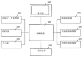
図2はこのようなナビゲーションシステムの概要を示すブロック構成図であり、各種の指示をする入力部240、衛星からの電波を受信して現在位置を検出するGPS部230、地図データを格納したDVDやハードディスクなどの記憶媒体から地図データを読み出す地図データ取得部220、全体を制御する制御装置250、処理結果を表示する表示部210、出発地から目的地までの誘導経路の探索を行う経路探索部270、地図データ取得部220から地図データを読み出し、入力部240から入力された車両種別に対応する交通規制情報があるかどうかを判断して、情報がある場合はその情報を取得する交通規制処理部280、GPSから受信した時刻情報をもとに時間や月日曜日情報を特定する時間情報取得部290から構成されている。
FIG. 2 is a block diagram showing an outline of such a navigation system. An
このような構成のナビゲーションシステムにおいては、電源を投入すると、GPS部230はGPS衛星からの電波を取得し、自装置が位置する現在位置の緯度および経度の検出を開始し、その検出結果を制御装置250に入力する。
In the navigation system having such a configuration, when the power is turned on, the
一方、制御装置250は、電源投入後の初期化処理を行った後、GPS部230から入力される現在位置の緯度経度の情報を用いて、地図データ取得部220で現在位置を中心とした所定範囲の地図データを読み出し、その地図データを可視化した地図を表示部210に表示させる。
On the other hand, the
経路探索を行う場合は、表示部210の上部に表示されているコマンドメニューから目的地検索のメニューが選択されると、目的地の緯度経度や住所名称などを選ぶことで目的地が決定される。目的地が決まるとその位置までの最適な経路を地図データ取得部220で取得した地図データ、交通規制処理部280で判断した規制情報、時間情報取得部290で取得した時間・月日曜日情報を用いて経路探索部270で総合的に判断し、複数の経路候補情報を作成する。複数の経路候補情報が表示部210に表示されると使用者はその中から1つを選択することで案内経路が決定する。
When performing a route search, when the destination search menu is selected from the command menu displayed at the top of the
上記のような経路探索を行う際に、規制情報の扱いやその情報の正確性は重要である。高速道路や国道などの主要道路の規制情報は内容的に単純なものが多いが、細かい道路の規制情報は時間や曜日などで規制内容が変更されるような複雑な規制をもつ場合がある。 When performing the route search as described above, the handling of the regulation information and the accuracy of the information are important. The regulation information for major roads such as highways and national roads is often simple in terms of content, but the regulation information for fine roads may have complicated regulations that change the regulation contents depending on time or day of the week.
これまで、特許文献1に、時間または曜日などで規制内容が変更される交通規制情報に対してきめ細かな対応が取れる方法が提案されている。
So far,
しかしながら、上記従来例のナビゲーション装置においては、現実世界どおりの規制をカーナビゲーションデータフォーマットの仕様制限により正確に表現できていないものも存在している。そのような場合は現実世界どおりの規制情報が地図データとして格納されておらず、規制情報をカーナビゲーションデータフォーマットの仕様通りに入るように丸められて格納されている。 However, in the above-described conventional navigation apparatus, there is a navigation apparatus that cannot accurately represent regulations in the real world due to the specification restriction of the car navigation data format. In such a case, the regulation information as in the real world is not stored as map data, and the regulation information is rounded and stored so as to fit the specification of the car navigation data format.
複雑な規制が付く箇所は高速道路や国道・県道などの主要な道路ではなく、細かいレベルの細道路に多いため経路探索対象になる可能性が低く問題となる可能性も低いとの考えでそうしているものと思われる。 It seems that the places where complicated regulations are attached are not major roads such as expressways, national roads, prefectural roads, etc., but because they are often narrow roads at a fine level, they are unlikely to be subject to route search and are unlikely to be a problem It seems to have done.
この問題はカーナビゲーションデータのフォーマットをどのような現実世界の規制情報でも全て表現できる形式に変更すれば解決するが、カーナビゲーションデータのフォーマットを変えるということはカーナビゲーションデータを作成する側やハードウェア側や車載ソフト側とかなり広範囲に影響を及ぼすために容易に変更できるものではない。 This problem can be solved by changing the format of the car navigation data to a format that can express any real-world regulatory information, but changing the format of the car navigation data means that the car navigation data creation side or hardware Side and the in-vehicle software side have a fairly wide range of influences and cannot be easily changed.
また、特許文献1に提案されている方法では時間または曜日などで規制内容が変更される交通規制情報に対して論理積または論理和を取ることである程度のきめ細やかな対応は取れるが、一定期間を除くような規制がある場合にはこの方法では対応できない。
Further, in the method proposed in
例えば一例として、「土日の8時から20時は通行不可だが8月1日から10月31日を除く」などのある曜日時間に該当する間は通行不可だが、その規制が適用されない期間があるようなケースである。 For example, there is a period in which traffic is not allowed during certain days of the week, such as “cannot pass from 8:00 to 20:00 on Saturdays and Sundays, but excludes from August 1 to October 31”, but the regulation is not applicable. This is the case.
本発明の目的は、これらの問題を解決するものであり、カーナビゲーションデータフォーマットのフォーマット仕様制限上の問題により、現実世界の規制を正しく表現していないデータを保持していても、また現実世界でどのような複雑な規制表現であっても通行可否情報提供システムに問い合わせることによって現実世界通りの規制を考慮した通行可否情報を端末側で取得することができるようになる通行可否情報提供システムを提供することにある。 An object of the present invention is to solve these problems. Even if data that does not correctly represent real-world regulations is retained due to a problem in the format specification limitation of the car navigation data format, the real-world A pass / fail information providing system that allows a terminal to obtain pass / fail information in consideration of real world regulations by inquiring to the pass / fail information providing system for any complicated regulation expression. It is to provide.
上記目的を達成するために、本発明の通行可否情報提供システムは、緯度経度情報に該当する部分の規制データを適用部分と適用除外部分を併せ持つ規制情報データベースを持ち、端末装置からの経路情報の送信を受信する受信手段と端末装置からの経路情報の送信を受けて、経路情報中の緯度経度に対応した規制データを前記規制情報データベースから読み出して通行可否を判定する手段と経路探索結果を要求元の端末装置に向けて送信する送受信手段を特徴とするものである。 In order to achieve the above object, the access permission / prohibition information providing system of the present invention has a restriction information database having both an application part and an application exclusion part of restriction data corresponding to latitude / longitude information, and includes route information from a terminal device. Upon receiving the transmission of route information from the receiving means and the terminal device that receives the transmission, the restriction data corresponding to the latitude and longitude in the route information is read from the restriction information database and the route search result is requested and the route search result is requested. It is characterized by transmitting / receiving means for transmitting to the original terminal device.
また、前記規制データが適用部分と適用除外部分を併せ持つことによって車両種別に応じた現実世界通りの月日時間曜日規制を抽出する交通規制取得方法を特徴とするものである。 In addition, the present invention is characterized by a traffic regulation acquisition method for extracting the regulation of the actual day, month, day, and day of the week according to the vehicle type by having both the application part and the application exclusion part in the restriction data.
本発明の通行可否情報提供システムによれば、次のような効果がある。
(1)移動端末側が保持している規制データに正しくないものが存在していても、通行可否情報提供システムに問い合わせることで現実世界通りの通行可否が判断でき、誤誘導をすることを防止できる。
(2)現状のカーナビゲーションデータフォーマット上の制限により、現実通りの規制を表現できていない場合であってもそのカーナビゲーションフォーマットをまったく変更する必要なく、通行可否情報提供システムに問い合わせることで現実世界通りの通行可否が判断でき、誤誘導をすることを防止できる。
(3)通行可否情報提供システム側にすべての規制データを正しく保持しているため、端末側は極端な場合、規制データをまったく保持する必要がなくなり、DVDやハードディスク上に保持している地図データの容量削減も可能となる。
(4)規制データとして適用除外区間の情報をもつことによって、保持している規制データの容量削減が可能となる。
According to the passability information providing system of the present invention, there are the following effects.
(1) Even if there is an incorrect restriction data held on the mobile terminal side, it is possible to determine whether or not traffic is allowed in the real world by making an inquiry to the passability information providing system, and to prevent erroneous guidance. .
(2) Due to restrictions on the current car navigation data format, even if the actual regulations cannot be expressed, it is not necessary to change the car navigation format at all. It is possible to determine whether or not the street can pass and prevent erroneous guidance.
(3) Since all restriction data is correctly held on the passability information providing system side, the terminal side does not need to hold the restriction data at all in an extreme case, and the map data held on the DVD or hard disk The capacity can be reduced.
(4) Having the information on the excluded section as the restriction data makes it possible to reduce the capacity of the restriction data that is held.
以下、本発明を適用した通行可否情報提供システムの実施形態について説明する。 Hereinafter, an embodiment of a passability information providing system to which the present invention is applied will be described.
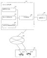
図1は、本発明の実施形態のシステム構成図であり、本通行可否情報提供システムは、規制情報データベース150を備えた通行可否情報提供装置100と移動端末装置170−1と170−2から構成され、通行可否情報提供装置100と端末装置170−1と170−2は公衆回線網によるネットワーク160で接続されている。
FIG. 1 is a system configuration diagram of an embodiment of the present invention, and the system for providing passability information includes a passability
通行可否情報提供装置100の規制情報データベース150には世界各国の道路や交差点上の交通規制データが登録されている。
Traffic regulation data on roads and intersections around the world is registered in the
また、通行可否情報提供装置100は、全体を制御する中央制御部140、移動端末170から送られてくる経路情報を受信する経路情報受信部110、受信した経路情報と規制情報データベース150から通行可否を判断する通行可否判定処理部120、通行可否判定処理部120が判定した経路情報に含まれる道路、交差点に対し通行可否結果を返却する通行可否判定結果送信部130を備えている。
Further, the access permission / prohibition
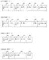
図3は規制情報データベース150に格納される本実施の形態における交通規制情報のデータ構造を示している。
FIG. 3 shows the data structure of the traffic regulation information in the present embodiment stored in the
図3(a)は月日規制データを示しており、緯度・経度310、車種320、月日曜日区分330、開始月日340、終了月日350、時間帯360、除外期間ID配列370の各データから成っている。緯度・経度310は規制情報を持つ道路の場合はその道路を特定できる唯一の位置を表し、交差点の場合は交差点の位置を表す。車種320は一般車両、バス、トラック、緊急車両等の区別があり、月日曜日区分330は月日を指定するのか曜日を指定するのかを識別するためのデータであるが、図3(a)は月日規制データなので月日が設定される。除外期間ID配列370は図3(a)で表す月日規制期間から規制が適用されない期間を除外するための情報である図3(c)除外月日期間データ又は図3(d)除外曜日期間データを指し示すID情報であり、除外期間ID配列370に格納されている番号で関係付けられている。除外期間情報が存在しない場合は0が格納される。
FIG. 3 (a) shows the month / day restriction data. Each data of latitude /
図3(b)は曜日規制データを示しており、経度・緯度310、車種320、月日曜日区分330、曜日情報380、時間帯360、除外期間ID配列370の各データから成っている。図3(b)は曜日規制データなので曜日が設定される。除外期間ID配列370は図3(b)で表す曜日規制期間から規制が適用されない期間を除外するための情報である図3(c)除外月日期間データ又は図3(d)除外曜日期間データを指し示すID情報であり、除外期間ID配列370に格納されている番号で関係付けられている。除外期間情報が存在しない場合は0が格納される。
FIG. 3B shows day-of-week restriction data, which includes data of longitude /
図3(c)は除外月日期間データを示しており、除外期間ID390、月日曜日区分330、除外開始月日340、除外終了月日350、除外時間帯360の各データから成っている。
FIG. 3 (c) shows exclusion month / day period data, which includes
図3(d)は除外曜日期間データを示しており、除外期間ID390、月日曜日区分330、除外曜日情報380、除外時間帯360の各データから成っている。
FIG. 3 (d) shows the excluded day period data, which is composed of data of an excluded
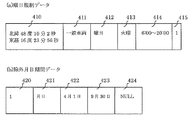
ここで例えば、ある地点の規制データを図4に示す。
緯度・経度410で表される北緯48度10分20秒、東経16度23分56秒の地点には車種411で表される一般車両が月日曜日区分412で表される曜日の規制情報を持ち、その曜日、時間は曜日情報413と時間情報414で表される火曜日の6:00〜20:00の規制があることを表している。また除外期間ID415が1となっているので除外期間情報を持っていることになる。その除外期間は除外期間ID420で表されるID=1で曜日規制データと関連付いており、月日曜日区分421で表される月日の除外期間情報を持ち、除外開始月日422と除外終了月日423から4月1日から9月30日は除外期間であることを表している。除外時間423はNULLとなっているため、除外する時間は存在していないことになる。
Here, for example, restriction data at a certain point is shown in FIG.
A general vehicle represented by a
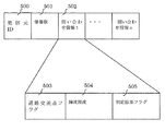
図5は移動端末170から通行可否情報提供システムへ送信するデータのデータ構成図である。これは通行可否情報提供システムから移動端末170へ送信するデータも同じ形式である。発信元ID500、情報数501、問い合わせ情報502から成っている。問い合わせ情報の中は道路交差点フラグ503、緯度経度504、判定結果フラグ505で構成されている。発信元ID500は移動端末を特定するIDである。情報数501は問い合わせ情報の数を表す。問い合わせ情報502は移動端末から問い合わせたい道路や交差点の情報が格納されている。道路交差点フラグ503はその情報が道路なのか交差点なのかを識別するフラグである。緯度経度504は道路の場合は道路が唯一特定できる場所の緯度経度、交差点の場合は交差点の位置の緯度経度である。交差点の場合は進入・退出の道路によって通行可否が変わることがあるため通行経路となる進入道路と退出道路の情報に挟まれた形で問い合わせる必要がある。判定結果フラグ505は通行可否情報提供システムで判定した結果を表す。移動端末170からの問い合わせ時には初期値が格納されている。
FIG. 5 is a data configuration diagram of data transmitted from the
以下、以上のように構成された通行可否情報提供システムの動作を説明する。 Hereinafter, the operation of the passability information providing system configured as described above will be described.
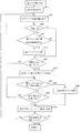
図6は通行可否情報提供装置100の通行可否情報判定処理の概要を示すフローチャートである。通行可否情報提供システム100はまず、通行可否を問い合わせたい移動端末170から送られてくる経路情報を取得する(ステップ600)。経路情報にはノードやリンクの緯度・経度情報を含んでいるため、その緯度経度に該当する規制情報を規制情報DB150から取得する(ステップ601)。通行可否を問い合わせたい移動端末170からは車種情報が送られてきているためその車種情報と規制情報が持つ車種情報が一致するかどうかを判定する(ステップ602)。一致しない場合はその規制情報は関係しないため、次の規制情報を処理することになる。車種が一致する場合は通行可否を問い合わせたい移動端末170から現在の月日時間曜日情報が送られてきているためその月日曜日時間情報が規制情報が持つ月日時間情報もしくは曜日時間情報の範囲内かどうかを判定する(ステップ603)。ここで範囲外の場合はその規制情報は関係しないため、次の規制情報を処理することになる。
FIG. 6 is a flowchart showing an outline of the passability information determination process of the passability
範囲内の場合は通行不可フラグを通行不可能であることを表すON状態にしておく(ステップ604)。 If it is within the range, it is set to the ON state indicating that the passage prohibition flag cannot pass (step 604).
規制情報数分ステップ602、603、604を処理したかどうかを判定する(ステップ605)。規制情報数分処理していない場合は、ステップ602、603、604を繰り返す。
It is determined whether or not
規制情報数分処理した場合は、規制情報が持つ除外期間IDに該当する除外期間情報を規制情報DB150から取得する(ステップ606)。現在の月日時間曜日情報が除外期間情報の範囲内かどうかを判定する(ステップ607)。除外期間情報の範囲内である場合は通行可能状態なので通行可否フラグを通行可能状態であることを表すOFF状態にする(ステップ608)。除外期間情報の範囲内でない場合は除外期間に該当しないので次の除外期間情報を処理することになる。 When processing is performed for the number of pieces of restriction information, exclusion period information corresponding to the exclusion period ID included in the restriction information is acquired from the restriction information DB 150 (step 606). It is determined whether the current date and time information is within the exclusion period information range (step 607). If it is within the range of the exclusion period information, it is in a passable state, so the passability flag is set to an OFF state indicating that the passable state is present (step 608). If it is not within the range of the exclusion period information, it does not correspond to the exclusion period, so the next exclusion period information is processed.
除外期間情報数分ステップ607、608、609を処理したかどうかを判定する(ステップ610)。除外期間情報数分処理していない場合は、ステップ607、608、609を繰り返す。
It is determined whether or not
処理したノード・リンクに対する通行不可フラグが通行不可能を表すON状態になっているものについてはその情報を退避しておく(ステップ610)。 The information about the nodes in which the incompatibility flag for the processed node / link is in the ON state indicating the inability to pass is saved (step 610).
経路情報数分処理したかどうかを判定する(ステップ611)。処理していない場合はステップ601以降の処理を継続する。経路情報数分処理済みの場合は全てのノード・リンクに対する通行可否判定結果が求まったことになる。
It is determined whether or not processing has been performed for the number of route information (step 611). If not, the processing after
最終的には通行可否情報提供システム100の通行可否判定処理部110が求めた通行可否判定結果を通行可否判定結果送信部120が移動端末170に結果送信することで移動端末側が問い合わせた経路情報のうち通行不可のノード、リンクがどれなのかを把握することが可能となる。
Finally, the passability determination result obtained by the passability determination result obtained by the passability
自動車やオートバイなどの車載用のナビゲーションシステムと通信を行う通行可否情報提供システムに利用可能である。携帯電話機などの携帯端末におけるナビゲーションシステムと通信を行う通行可否情報提供システムに利用可能である。パソコンからインターネットを介してアクセスを行う通行可否情報提供システムに利用可能である。 The present invention can be used for a passability information providing system that communicates with an in-vehicle navigation system such as an automobile or a motorcycle. The present invention can be used for a passability information providing system that communicates with a navigation system in a mobile terminal such as a mobile phone. It can be used for a pass / fail information providing system that is accessed from a personal computer via the Internet.
100 通行可否情報提供装置
110 経路情報受信部
120 通行可否判定処理部
130 通行可否判定結果送信部
140 中央制御部
150 規制情報DB
160 公衆回線網
170 移動端末
210 表示部
220 地図データ処理部
230 GPS部
240 入力部
250 中央制御装置
260 送受信部
270 経路探索部
280 交通規制処理部
290 時間情報取得部
100 Accessibility
160
Claims (2)
前記規制情報データベースが格納する規制情報は、月日、曜日、時間に関する適用部分と適用除外部分とを併せ持つ構造を有しており、
前記通行可否判定処理部は、
前記経路情報受信部が受信した経路情報に基づいて、前記規制情報データベースを検索して該当する月日、曜日、時間が規制範囲内か否かを判定する規制範囲検索手段と、
該規制範囲検索手段により、該当する規制が見つかった場合に、その適用除外期間のデータを取得して、該当する月日、曜日、時間が除外期間内か否かを判定する除外期間検索手段と、
を有し、
現実の交通規制通りの時間規制による通行可否判定結果を前記端末装置に返すことを特徴とする通行可否情報提供システム。 Having a regulation information database storing regulation information for vehicles on the road corresponding to latitude and longitude information, receiving a route information receiving unit that receives transmission of route information from the terminal device, and receiving transmission of route information from the terminal device A passability determination processing unit that reads out the restriction data corresponding to the latitude and longitude in the route information from the restriction information database and determines whether or not the vehicle is allowed to pass; and a passability determination that transmits a route search result to the requesting terminal device A passability information providing system having a result transmission unit,
The regulation information stored in the regulation information database has a structure having both an application part and an application exclusion part regarding the date, day of the week, and time,
The passage permission determination processing unit
Based on the route information received by the route information receiving unit, a restriction range search means for searching the restriction information database to determine whether the corresponding date, day, and time are within the restriction range;
Exclusion period search means for obtaining data of the exemption period when the restriction is found by the restriction range search means, and determining whether the applicable date, day, and time are within the exclusion period; ,
Have
A passability information providing system that returns a passability determination result based on time restrictions according to actual traffic restrictions to the terminal device.
前記規制情報データベースが格納する規制情報は、月日、曜日、時間に関する適用部分と適用除外部分とを併せ持つ構造を有しており、
前記通行可否判定処理部が処理する通行可否判定処理は、
前記経路情報受信部が受信した経路情報に基づいて、前記規制情報データベースを検索して該当する月日、曜日、時間が規制範囲内か否かを判定する規制範囲検索ステップと、
該規制範囲検索ステップにより、該当する規制が見つかった場合に、その適用除外期間のデータを取得して、該当する月日、曜日、時間が除外期間内か否かを判定する除外期間検索ステップと、
を有し、
現実の交通規制通りの時間規制による通行可否判定結果を前記端末装置に返すことを特徴とする通行可否情報提供方法。
前記規制データが適用部分と適用除外部分を併せ持つことによって車両種別に応じた現実世界通りの月日時間曜日規制を抽出する通行可否情報提供方法。 Having a regulation information database storing regulation information for vehicles on the road corresponding to latitude and longitude information, receiving a route information receiving unit that receives transmission of route information from the terminal device, and receiving transmission of route information from the terminal device A passability determination processing unit that reads out the restriction data corresponding to the latitude and longitude in the route information from the restriction information database and determines whether or not the vehicle is allowed to pass; and a passability determination that transmits a route search result to the requesting terminal device A passability information providing method using a passability information providing system having a result transmission unit,
The regulation information stored in the regulation information database has a structure having both an application part and an application exclusion part regarding the date, day of the week, and time,
The passability determination process processed by the passability determination processing unit is as follows.
Based on the route information received by the route information receiving unit, a restriction range search step of searching the restriction information database to determine whether the corresponding date, day, and time are within the restriction range;
An exclusion period search step of obtaining data of the exemption period when the regulation is found by the restriction range search step, and determining whether the applicable date, day, and time are within the exclusion period; ,
Have
A method for providing passability information, wherein a passability determination result based on time restrictions according to actual traffic restrictions is returned to the terminal device.
A passability information providing method for extracting a real-day, day-time, day-of-week regulation according to a vehicle type by combining the restriction data with an application part and an exclusion part.
Priority Applications (1)
| Application Number | Priority Date | Filing Date | Title |
|---|---|---|---|
| JP2009219020A JP2011069643A (en) | 2009-09-24 | 2009-09-24 | System and method for providing passage propriety information |
Applications Claiming Priority (1)
| Application Number | Priority Date | Filing Date | Title |
|---|---|---|---|
| JP2009219020A JP2011069643A (en) | 2009-09-24 | 2009-09-24 | System and method for providing passage propriety information |
Publications (1)
| Publication Number | Publication Date |
|---|---|
| JP2011069643A true JP2011069643A (en) | 2011-04-07 |
Family
ID=44015060
Family Applications (1)
| Application Number | Title | Priority Date | Filing Date |
|---|---|---|---|
| JP2009219020A Pending JP2011069643A (en) | 2009-09-24 | 2009-09-24 | System and method for providing passage propriety information |
Country Status (1)
| Country | Link |
|---|---|
| JP (1) | JP2011069643A (en) |
Citations (3)
| Publication number | Priority date | Publication date | Assignee | Title |
|---|---|---|---|---|
| JP2001227977A (en) * | 2000-02-21 | 2001-08-24 | Junji Omori | Route navigation system and route navigation device |
| JP2003315064A (en) * | 2002-04-26 | 2003-11-06 | Denso Corp | In-vehicle navigation device |
| JP2008128909A (en) * | 2006-11-22 | 2008-06-05 | Denso Corp | Car navigation system |
-
2009
- 2009-09-24 JP JP2009219020A patent/JP2011069643A/en active Pending
Patent Citations (3)
| Publication number | Priority date | Publication date | Assignee | Title |
|---|---|---|---|---|
| JP2001227977A (en) * | 2000-02-21 | 2001-08-24 | Junji Omori | Route navigation system and route navigation device |
| JP2003315064A (en) * | 2002-04-26 | 2003-11-06 | Denso Corp | In-vehicle navigation device |
| JP2008128909A (en) * | 2006-11-22 | 2008-06-05 | Denso Corp | Car navigation system |
Similar Documents
| Publication | Publication Date | Title |
|---|---|---|
| EP2622309B1 (en) | Navigation device, navigation method, and program | |
| CN1323283C (en) | Navigation device for vehicle and method for guiding vehicle using same | |
| US10876848B2 (en) | Methods and systems for generating routes | |
| US20050251334A1 (en) | Electronic device having map display function and program for the same | |
| US8396652B2 (en) | Map data providing method | |
| US10101165B2 (en) | Electronic device and method for planning tour route | |
| US9709416B2 (en) | Destination proposal system, destination proposal method, and storage medium for program product | |
| US20100305842A1 (en) | METHOD AND APPARATUS TO FILTER AND DISPLAY ONLY POIs CLOSEST TO A ROUTE | |
| US6366834B1 (en) | Time display method and apparatus | |
| JP7013512B2 (en) | Information processing device, route guidance device, program, and information processing method | |
| WO2014208154A1 (en) | Position information sharing system, position information sharing method, and position information sharing program | |
| US20090043488A1 (en) | Navigation system, server, method, and program | |
| JP2003195743A (en) | Map display system, map display device, and map display program | |
| JP2003194562A (en) | System, device and program for map display and information center | |
| JP2023174913A (en) | Information generation device, information generation method, and information processing device | |
| JP3441674B2 (en) | Navigation device and storage medium | |
| US10234304B2 (en) | Map information creating device, navigation system, information display method, information display program, and recording medium | |
| US20060047424A1 (en) | Navigation device, data structure, and route search and display method | |
| JP2005233972A (en) | Navigation device | |
| JP2011069643A (en) | System and method for providing passage propriety information | |
| JP4886631B2 (en) | Route calculation device, route guidance device, and route calculation method | |
| JP3991320B2 (en) | Navigation device | |
| JP3879861B2 (en) | Navigation device and navigation method | |
| JP7032471B2 (en) | Information processing device, route guidance device, program, and information processing method | |
| JP5091050B2 (en) | Navigation device |
Legal Events
| Date | Code | Title | Description |
|---|---|---|---|
| A621 | Written request for application examination |
Effective date: 20111227 Free format text: JAPANESE INTERMEDIATE CODE: A621 |
|
| A977 | Report on retrieval |
Free format text: JAPANESE INTERMEDIATE CODE: A971007 Effective date: 20130520 |
|
| A131 | Notification of reasons for refusal |
Free format text: JAPANESE INTERMEDIATE CODE: A131 Effective date: 20130528 |
|
| A02 | Decision of refusal |
Free format text: JAPANESE INTERMEDIATE CODE: A02 Effective date: 20131001 |