JP2009098099A - Positioning device for mobile body - Google Patents
Positioning device for mobile body Download PDFInfo
- Publication number
- JP2009098099A JP2009098099A JP2007272459A JP2007272459A JP2009098099A JP 2009098099 A JP2009098099 A JP 2009098099A JP 2007272459 A JP2007272459 A JP 2007272459A JP 2007272459 A JP2007272459 A JP 2007272459A JP 2009098099 A JP2009098099 A JP 2009098099A
- Authority
- JP
- Japan
- Prior art keywords
- data
- calendar
- gps
- positioning
- satellite
- Prior art date
- Legal status (The legal status is an assumption and is not a legal conclusion. Google has not performed a legal analysis and makes no representation as to the accuracy of the status listed.)
- Withdrawn
Links
Images


Abstract
Description
本発明は、移動体の位置等を測位する移動体用測位装置に関する。 The present invention relates to a positioning device for a moving body that measures the position and the like of the moving body.
従来から、絶対座標を算出したい地点(未地点)、そこから近い地点(近地点)、国際GPS機関(IGS)等の機関から公開される地点(IGS点)に設置されているGPS受信システムが収集するGPS観測データを用いて、基線解析を実施し、そのとき、測定する距離(基線長の長さ)に応じて使用するGPSの放送暦、速報暦又は最終暦を選択して用いる技術が知られている(例えば、特許文献1参照)。この技術では、最終暦を用いてIGS点−近地点間及びIGS点−未地点間の基線解析を行うとともに、放送暦又は速報暦を用いて近地点−未地点間の基線解析を行っている。尚、この技術では、IGS等の機関から提供されるGPSの放送暦、速報暦、最終暦が用いられている。
ところで、国際GPS機関から提供される一般的な精密暦(最終暦)は、航法メッセージに含まれる放送暦が予報であるのとは対照的に、過去の記録であるから、リアルタイム計測に用いることができない。しかしながら、近年では、国際GPS機関等の機関から、予報を含む精密暦が提供されている。 By the way, the general precision calendar (final calendar) provided by the international GPS organization is a past record as opposed to the broadcast calendar included in the navigation message being a forecast, so it should be used for real-time measurement. I can't. However, in recent years, precise calendars including forecasts have been provided by organizations such as the international GPS organization.
そこで、本発明は、航法メッセージの一部として送信される暦データと精密暦の予報データとを適切に組み合わせて用いることで移動体の位置等を精度良く測位することができる移動体用測位装置の提供を目的とする。 Therefore, the present invention provides a positioning device for a moving body that can accurately position the position of the moving body by using an appropriate combination of calendar data transmitted as a part of a navigation message and forecast data of a precise calendar. The purpose is to provide.
上記目的を達成するため、第1の発明に係る移動体用測位装置は、航法メッセージの一部として送信される暦データを受信する手段と、
精密暦の予報データを受信する手段と、
前記暦データと前記精密暦の予報データの双方を用いて衛星位置を算出する衛星位置算出手段と、
前記算出された衛星位置に基づいて、移動体の位置又は速度を測位する測位手段とを備え、
前記衛星位置算出手段は、前記暦データ及び前記精密暦のうちの少なくとも一方のデータの鮮度を算出し、該算出した鮮度に応じた重みにより前記暦データと前記精密暦の予報データを加重平均して用いることを特徴とする。
In order to achieve the above object, a mobile positioning device according to the first invention comprises means for receiving calendar data transmitted as part of a navigation message,
Means for receiving forecast data for a precise calendar;
Satellite position calculating means for calculating a satellite position using both the calendar data and the forecast data of the fine calendar;
Positioning means for positioning the position or speed of the moving body based on the calculated satellite position;
The satellite position calculating means calculates a freshness of at least one of the calendar data and the fine calendar, and performs a weighted average of the calendar data and the forecast data of the fine calendar with a weight according to the calculated freshness. It is characterized by using.
第2の発明は、第1の発明に係る移動体用測位装置において、
前記測位手段により測位された測位結果を、慣性航法により測位された測位結果と比較し、その比較結果に応じて前記重み付けに用いる係数を更新することを特徴とする。
2nd invention is the positioning apparatus for moving bodies which concerns on 1st invention,
The positioning result determined by the positioning means is compared with the positioning result determined by inertial navigation, and the coefficient used for the weighting is updated according to the comparison result.
第3の発明は、第1又は2の発明に係る移動体用測位装置において、
前記データの鮮度は、該データの直近の更新時点からの経過時間に基づいて算出されることを特徴とする。
3rd invention is the positioning apparatus for moving bodies which concerns on 1st or 2nd invention,
The freshness of the data is calculated based on an elapsed time from the latest update time of the data.
本発明によれば、航法メッセージの一部として送信される暦データと精密暦の予報データとを適切に組み合わせて用いることで移動体の位置等を精度良く測位することができる移動体用測位装置が得られる。 ADVANTAGE OF THE INVENTION According to this invention, the positioning apparatus for moving bodies which can measure the position of a moving body, etc. accurately by using appropriately combining the calendar data transmitted as a part of the navigation message and the forecast data of the precise calendar. Is obtained.
以下、図面を参照して、本発明を実施するための最良の形態の説明を行う。 The best mode for carrying out the present invention will be described below with reference to the drawings.
図1は、本発明に係る移動体位置測位装置が適用されるGPS(Global Positioning System)の全体的な構成を示すシステム構成図である。図1に示すように、GPSは、地球周りを周回するGPS衛星10と、地球上に位置し地球上を移動しうる車両90とから構成される。尚、車両90は、あくまで移動体の一例であり、その他の移動体としては、自動二輪車、鉄道、船舶、航空機、ホークリフト、ロボットや、人の移動に伴い移動する携帯電話等の情報端末等がありうる。
FIG. 1 is a system configuration diagram showing an overall configuration of a GPS (Global Positioning System) to which a mobile body positioning device according to the present invention is applied. As shown in FIG. 1, the GPS is composed of a GPS satellite 10 that orbits the earth and a
GPS衛星10は、航法メッセージ(衛星信号)を地球に向けて常時放送する。航法メッセージには、対応するGPS衛星10に関する放送暦、GPS衛星10に搭載の時計の補正値、電離層の補正係数が含まれている。尚、放送暦は、地上の制御部分で行われた軌道追跡データに基づく予報値であり、ケプラー軌道要素と補正係数を含む。以下では、航法メッセージに含まれる放送暦と時計の補正値のデータを含めて、GPS暦データと称する。 The GPS satellite 10 constantly broadcasts navigation messages (satellite signals) toward the earth. The navigation message includes the broadcast calendar for the corresponding GPS satellite 10, the correction value of the clock mounted on the GPS satellite 10, and the ionospheric correction coefficient. The broadcast calendar is a forecast value based on orbit tracking data performed in the control part on the ground, and includes a Kepler orbit element and a correction coefficient. Hereinafter, the broadcast calendar and clock correction value data included in the navigation message are referred to as GPS calendar data.
航法メッセージは、C/Aコードにより拡散されL1波(周波数:1575.42MHz)に乗せられて、地球に向けて常時放送されている。尚、L1波は、C/Aコードで変調されたSin波とPコード(Precision Code)で変調されたCos波の合成波であり、直交変調されている。C/Aコード及びPコードは、擬似雑音(Pseudo Noise)符号であり、−1と1が不規則に周期的に並ぶ符号列である。 The navigation message is spread by the C / A code, is carried on the L1 wave (frequency: 1575.42 MHz), and is constantly broadcast toward the earth. The L1 wave is a combined wave of a Sin wave modulated with a C / A code and a Cos wave modulated with a P code (Precision Code), and is orthogonally modulated. The C / A code and the P code are pseudo noise codes, and are a code string in which -1 and 1 are irregularly arranged periodically.
尚、現在、24個のGPS衛星10が高度約20,000kmの上空で地球を一周しており、各4個のGPS衛星10が55度ずつ傾いた6つの地球周回軌道面に均等に配置されている。従って、天空が開けている場所であれば、地球上のどの場所にいても、常時、少なくとも5個以上のGPS衛星10が観測可能である。 Currently, 24 GPS satellites 10 orbit the earth at an altitude of about 20,000 km, and each of the four GPS satellites 10 is evenly arranged on six Earth orbit planes inclined by 55 degrees. ing. Therefore, as long as the sky is open, at least five GPS satellites 10 can be observed at any time on the earth.
車両90には、移動体位置測位装置としてのGPS受信機1が搭載される。GPS受信機1は、以下で詳説する如く、GPS衛星10からの衛星信号に基づいて、車両90の位置や速度を実時間で測位する。
The
図2は、図1の車両90に搭載されるGPS受信機1の一実施例を示す概略的なシステム構成図である。図2には、説明の複雑化を避けるため、GPS衛星101(下付きの符号は、衛星番号)が1つだけ示されている。ここでは、GPS衛星101からの衛星信号に関する信号処理について代表して説明する。GPS衛星101からの衛星信号に関する信号処理は、他のGPS衛星102,103等からの衛星信号に関する信号処理と実質的に同じである。実際には、以下で説明する衛星信号に関する信号処理は、観測可能な各GPS衛星101,102,103等からの衛星信号に対して並列的(同時)に実行されることになる。
FIG. 2 is a schematic system configuration diagram showing an embodiment of the GPS receiver 1 mounted on the
本実施例のGPS受信機1は、図2に示すように、主要な機能部として、受信部20、測位演算部40、加重平均部50、及び、通信部70を備える。
As shown in FIG. 2, the GPS receiver 1 according to the present embodiment includes a
受信部20は、GPS衛星101から発信されている衛星信号をGPSアンテナ22を介して受信し、内部で発生させたレプリカC/Aコードを用いてC/Aコード同期を行い、航法メッセージを取り出す。C/Aコード同期の方法は、多種多様でありえ、任意の適切な方法が採用されてよい。例えば、DDL(Delay―Locked
Loop)を用いて、受信したC/Aコードに対するレプリカC/Aコードの相関値がピークとなるコード位相を追尾する方法であってよい。受信部20は、航法メッセージが更新される毎に、航法メッセージを、加重平均部50及び測位演算部40に供給する。
Receiving
Loop) may be used to track the code phase at which the correlation value of the replica C / A code with respect to the received C / A code peaks. The
また、受信部20は、GPS衛星101からの衛星信号の受信結果に基づいて、GPS衛星101と車両90(正確にはGPS受信機1)との間の擬似距離ρを算出する。擬似距離ρとは、GPS衛星101と車両90との間の真の距離とは異なり、GPS受信機1の時計誤差(クロックバイアス)や、電離層遅延誤差のような電波伝搬速度変化による誤差を含む。
The receiving
ここで、GPS衛星101に対する擬似距離ρは、例えば以下のように算出されてよい。
ρ=N×300
ここで、Nは、GPS衛星101と車両90との間のC/Aコードのビット数に相当し、レプリカC/Aコードの位相及びGPS受信機1内部の受信機時計に基づいて算出される。尚、数値300は、C/Aコードが、1ビットの長さが1μsであり、1ビットに相当する長さが約300m(1μs×光速)であることに由来する。このようにして算出された擬似距離ρを表す信号は、GPS観測データとして測位演算部40に入力される。尚、擬似距離ρは、キャリアスムージング等のような適切なフィルタ処理を受けてから測位演算部40に入力されてもよい。
Here, the pseudorange ρ with respect to the GPS satellite 10 1, for example, may be calculated as follows.
ρ = N × 300
Here, N corresponds to the number of bits of the C / A code between the GPS satellite 10 1 and the
更に、受信部20は、衛星信号の搬送波位相を測定する機能を備えてよい。具体的には、受信部20は、内部で発生させたレプリカキャリアを用いて、ドップラーシフトした受信搬送波のドップラー周波数変化量Δfを測定する。ドップラー周波数変化量Δfは、レプリカキャリアの周波数frと既知の搬送波周波数fc(1575.42MHz)の差分(=fr−fc)として測定される。この機能は、レプリカキャリアを用いてキャリア相関値を演算して受信キャリアを追尾するPLL(Phase−Locked Loop)により実現されてよい。ドップラー周波数変化量Δfを表す信号は、GPS観測データとして測位演算部40に入力される。
Further, the
通信部70は、アンテナ72を介して、外部センタ80との無線通信を介して精密暦の予報値を取得する。精密暦の予報データは、国際GPS機関(IGS)等の機関により提供されるデータであってよい。精密暦の予報値(以下、単に「精密暦データ」ともいう)は、衛星軌道及び衛星時計に関する予報値を含む。精密暦データは、必ずしも外部センタ80を介して取得される必要はなく、提供元の機関から直接的に取得されてもよい。通信部70は、例えばGPS受信機1の起動時に最新の精密暦データを取得し、その後、GPS受信機1が継続して動作している限り、最新の精密暦データが更新される毎に、最新の精密暦データを取得するように動作してよい。通信部70により取得される精密暦データは、加重平均部50に供給される。
The
加重平均部50は、受信部20により受信される航法メッセージ内のGPS暦データ(放送暦と時計の補正値)に基づいて、GPS衛星101のワールド座標系(例えばWGS84)での現時点の位置(X1、Y1、Z1)を計算する。尚、GPS暦データに基づいてGPS衛星101の位置を算出する方法は多種多様であり、任意の適切な方法が採用されてもよい。この際、加重平均部50は、好ましくは、GPS衛星101の時計の補正値(補正係数)を用いて、GPS衛星101の時計誤差が補償されたGPS衛星101の位置を算出する。尚、以下では、GPS暦データに基づき算出されるGPS衛星101の位置を下付き文字「G」を用いて、(XG1、YG1、ZG1)で表す。
The weighted
加重平均部50は、通信部70により取得される精密暦データ(衛星軌道及び衛星時計を表す予報データ)に基づいて、GPS衛星101のワールド座標系での現時点の位置(X1、Y1、Z1)を計算する。この際、加重平均部50は、上述のGPS暦データに基づくGPS衛星101の位置(XG1、YG1、ZG1)と同一時刻に係る位置(X1、Y1、Z1)を精密暦データに基づいて計算する。これは、例えばGPS時を基準として同期されてよい。加重平均部50は、例えば、精密暦データが例えば15分おきのGPS衛星101の位置を表す場合には、現時点のGPS衛星101の位置を補間により算出してよい。この際、加重平均部50は、好ましくは、GPS衛星101に係る衛星時計を表す予報データを用いて、GPS衛星101の時計誤差が補償されたGPS衛星101の位置を算出する。尚、以下では、GPS暦データに基づき算出されるGPS衛星101の位置を下付き文字「P」を用いて、(XP1、YP1、ZP1)で表す。
The weighted
加重平均部50は、上述の如く算出した2つのGPS衛星101の位置を結合して、最終的なGPS衛星101の位置(X1、Y1、Z1)を計算する。この際、加重平均部50は、2つのGPS衛星101の位置を、ある重みを掛けて加重平均し、最終的なGPS衛星101の位置(X1、Y1、Z1)を計算する。具体的には、重みをαとすると、以下の通りである。
(X1、Y1、Z1)=α×(XP1、YP1、ZP1)+(1−α)×(XG1、YG1、ZG1)
ここで、重み付け係数αは、|α|<1であり、GPS暦データ及び精密暦データの鮮度に依存して変化する可変値とされる。具体的には、例えば、以下のような式で決定されてよい。
α=1−t1/ΔT1 式(1)
ここで、ΔT1は、精密暦データの更新周期(本例では6時間)であり、t1は、直近の精密暦データの更新時からの現時点までの経過時間を表す。従って、直近の精密暦データの更新時からの現時点までの経過時間が長くなるにつれて、精密暦データに対する重み付けが小さくなり、且つ、GPS暦データに対する重み付けが大きくなる。これは、精密暦データの更新周期が長く、更新直後は非常に精度が高いが、更新後からの時間の経過と共に信頼性が悪くなることを考慮したものである。また、GPS暦データは、更新周期が短いが(現在、更新周期は2時間)、精度が全般的に精密暦データよりも悪いことを考慮したものである。尚、上記の式(1)は、直近の精密暦データの更新時からの現時点までの経過時間と共に連続的にαが減少する式となっているが、直近の精密暦データの更新時からの現時点までの経過時間と共に不連続的にαが減少するような式が用いられてもよい。このようにして加重平均により導出されたGPS衛星101の位置(X1、Y1、Z1)を表す信号は、測位演算部40に入力される。
The weighted
(X 1 , Y 1 , Z 1 ) = α × (X P1 , Y P1 , Z P1 ) + (1−α) × (X G1 , Y G1 , Z G1 )
Here, the weighting coefficient α is | α | <1, and is a variable value that changes depending on the freshness of the GPS calendar data and the precision calendar data. Specifically, for example, it may be determined by the following equation.
α = 1−t 1 / ΔT 1 Formula (1)
Here, ΔT 1 is the update period of the fine calendar data (6 hours in this example), and t 1 represents the elapsed time from the update of the latest fine calendar data to the present time. Therefore, as the elapsed time from the update of the latest precise calendar data to the present time becomes longer, the weight for the precision calendar data becomes smaller and the weight for the GPS calendar data becomes larger. This is because the update cycle of the precision calendar data is long and the accuracy is very high immediately after the update, but the reliability deteriorates with the passage of time after the update. The GPS calendar data takes into consideration that although the update cycle is short (currently, the update cycle is 2 hours), the accuracy is generally worse than that of the precise calendar data. The above equation (1) is a formula in which α continuously decreases with the elapsed time from the update of the most recent precise calendar data to the present time. An expression may be used in which α decreases discontinuously with the elapsed time up to the present time. A signal representing the position (X 1 , Y 1 , Z 1 ) of the GPS satellite 10 1 derived by the weighted average in this way is input to the
測位演算部40は、加重平均部50から供給される衛星位置の算出結果と、受信部20から供給される擬似距離ρの算出結果に基づいて、車両90の絶対位置(Xu,Yu,Zu)を測位する。具体的には、以下の関係式が用いられてよい。
ρ=√{(X1−Xu)2+(Y1−Yu)2+(Z1−Zu)2}+Δτ・c 式(2)
ここで、Δτ・cは、主に受信部20の時計誤差を表す。尚、この式は、GPS衛星101に関するものであるが、他の観測可能なGPS衛星10に対しても同様の関係式が利用される。車両90の位置は、3つのGPS衛星10に対して上述の如く得られるそれぞれの擬似距離ρ及び衛星位置を用いて、三角測量の原理で導出されてよい。この場合、擬似距離ρは上述の如く時計誤差を含むので、4つ目のGPS衛星10に対して得られる擬似距離ρ及び衛星位置を用いて、時計誤差成分が除去されてよい。
Positioning
ρ = √ {(X 1 −X u ) 2 + (Y 1 −Y u ) 2 + (Z 1 −Z u ) 2 } + Δτ · c Equation (2)
Here, Δτ · c mainly represents a clock error of the receiving
測位演算部40は、また、加重平均部50から供給される衛星位置の算出結果と、受信部20から供給されるドップラー周波数変化量Δfの算出結果に基づいて、車両90の速度を測位してもよい。
The
測位演算部40による測位周期は、例えば観測周期(例えば1ms)或いは所定数の観測周期(例えば50msや100ms)であってよい。測位結果(絶対位置や速度)は、例えば図示しないナビゲーションシステムに出力されてもよい。
The positioning cycle by the
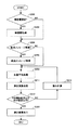
図3は、本実施例のGPS受信機1により実行される主要処理の流れを示すフローチャートである。 FIG. 3 is a flowchart showing a flow of main processing executed by the GPS receiver 1 of the present embodiment.
ステップ200では、通信部70において、精密暦データが更新されたか否かが判定される。精密暦データの更新は、基本的には6時間おきに行われる。尚、精密暦データが更新されたか否かは、外部センタ80からの情報に基づいて判断されてもよいし、前回の更新時からの経過時間(=t1)に基づいて判断されてもよい。精密暦データが更新された場合には、ステップ202に進み、精密暦データが更新されていない場合には、ステップ202をスキップしてステップ204に進む。
In
ステップ202では、通信部70において、更新された精密暦データが外部センタ80から取得される。更新された精密暦データの取得態様は、プッシュ型やプル型の如何なる方式であってもよい。
In
ステップ204では、受信部20において、GPS暦データが更新されたか否かが判定される。GPS暦データは、現在、2時間に1回更新されている。GPS暦データが更新されたか否かは、航法メッセージの解読結果に基づいて判断されてもよいし、前回の更新時からの経過時間に基づいて判断されてもよい。GPS暦データが更新された場合には、ステップ206に進み、GPS暦データが更新されていない場合には、ステップ206をスキップしてステップ208に進む。
In step 204, the receiving
ステップ206では、加重平均部50において、更新されたGPS暦データが受信部20から取得される。
In
ステップ208では、加重平均部50において、上述の如く算出態様で、GPS暦データ及び精密暦データに基づいて加重平均により、現在観測可能なGPS衛星10の各位置(X、Y、Z)が算出される。尚、重み付け係数αは、上述の如く可変値とされるが、急変が生じないようにフィルタ処理されてもよい。
In
ステップ210では、測位演算部40において、上述の如く算出態様で、上記ステップ208で得られたGPS衛星10の位置(X、Y、Z)等を用いて、車両90の位置(Xu,Yu,Zu)や速度が測位される。
In
ステップ220では、上記ステップ210の測位結果が例えばナビゲーション装置に出力され利用される。
In
以上説明した本実施例の移動体位置測位装置によれば、とりわけ、以下のような優れた効果が奏される。 According to the mobile body positioning apparatus of the present embodiment described above, the following excellent effects are achieved, among others.
上述の如く精密暦データとGPS暦データを、それぞれの特性・特徴に応じて適切に加重平均することで、衛星軌道誤差及び衛星時計誤差が低減された高精度の衛星位置を算出することができ、その結果、高精度の測位が可能となる。この点、更に詳説すると以下の通りである。放送暦は、現在、2時間に1回更新されているが、そのパラメータは24〜48時間前に予測されるものであるため、精度がさほど高くない。一方、精密暦は、現在、6時間に一回の更新であるが、世界中の300を超える施設を通じて、その観測結果から計算された精密なデータであるが故に、精度が良い。本実施例では、この点に着目し、各データの鮮度(更新周期や更新後の経過時間等)と、各データの精度との関係を考慮して、適切に重み付けを行うことで、高精度の衛星位置を算出することができ、その結果、高精度の測位が可能となる。 As described above, high-precision satellite positions with reduced satellite orbit errors and satellite clock errors can be calculated by appropriately weighting and averaging the precise calendar data and GPS calendar data according to the respective characteristics and features. As a result, highly accurate positioning is possible. This point will be described in further detail as follows. The broadcast calendar is currently updated once every two hours, but its parameters are predicted 24 to 48 hours ago, so the accuracy is not so high. On the other hand, the precision calendar is currently updated once every 6 hours, but it is accurate because it is precise data calculated from the observation results through more than 300 facilities around the world. In this embodiment, paying attention to this point, high accuracy is achieved by appropriately weighting in consideration of the relationship between the freshness of each data (update period, elapsed time after update, etc.) and the accuracy of each data. Can be calculated, and as a result, highly accurate positioning is possible.
次に、本発明による移動体位置測位装置のその他の実施例について説明する。以下では、このその他の実施例特有の構成について重点的に説明するが、他の構成は、上述の実施例と同様であってよい。 Next, another embodiment of the mobile body positioning device according to the present invention will be described. In the following, the configuration peculiar to the other embodiments will be described with emphasis, but the other configurations may be the same as those of the above-described embodiments.
図4は、本実施例のGPS受信機101を示す概略的なシステム構成図である。本実施例のGPS受信機101は、上述のGPS受信機1に対して、主に、INS測位部60と比較部62を更に備える点が異なる。図4において、上述の実施例と同様であってよい構成については同一の参照符号を付し、詳細な説明を省略する。
FIG. 4 is a schematic system configuration diagram showing the
INS測位部60は、3軸加速度センサ及び3軸角速度センサを含むIMU(慣性測定ユニット)64の出力信号に基づいて、車両90の位置や速度を実時間で測位する。慣性航法による車両位置の測位方法は、多種多様でありえ、如何なる方法であってもよい。例えば車両90の位置は、加速度センサの出力値に、姿勢変換、重力補正、コリオリ力補正を行って2回積分し、当該2回積分により得られる移動距離を、車両位置の初期値に積算することで導出されてよい。車両位置の初期値は、測位演算部40の過去の測位結果が利用されてもよい。INS測位部60により測位される車両位置及び車両速度(INS測位結果)は、測位演算部40により測位される車両位置及び車両速度(GPS測位結果)と同期して、比較部62に入力される。この同期は、例えばGPS時を基準として実現されてもよい。
The INS positioning unit 60 measures the position and speed of the
比較部62は、同期して入力される同一時刻に係るINS測位結果とGPS測位結果とを比較する。比較部62の比較処理の一例を後に説明する。比較部62の比較結果は、加重平均部50での加重平均処理に反映される。
The
図5は、本実施例のGPS受信機101により実行される主要処理の流れを示すフローチャートである。図5において、上述の実施例(図3)と同様であってよい処理については同一の参照符号を付し、詳細な説明を省略する。
FIG. 5 is a flowchart showing the flow of main processing executed by the
ステップ211では、測位演算部40において、上述の如く算出態様で、上記ステップ208で得られたGPS衛星10の位置(X、Y、Z)等を用いて、車両90の位置(Xu,Yu,Zu)や速度が測位される。また、INS測位部60において、慣性航法により車両90の位置(Xu,Yu,Zu)や速度が測位される。
In step 211, the
ステップ212では、比較部62において、上記ステップ211で得られるGPS測位結果とINS測位結果の間の偏差の絶対値が所定の閾値以内か否かが判定される。GPS測位結果とINS測位結果の間の偏差は、それぞれの測位結果に係る車両90の位置の間の距離により評価されてもよい。所定の閾値は、GPS測位結果とINS測位結果の間の整合性が取れていないことを検出できるような値に設定され、試験等により適合された値が用いられてもよい。GPS測位結果とINS測位結果の間の偏差の絶対値が所定の閾値以内である場合には、ステップ220に進み、それ以外の場合、ステップ214を介して、ステップ208に戻る。
In
ステップ214では、加重平均部50において、重み付け係数αが変更(調整)され、当該変更後の重み付け係数αを用いて、上述の如く算出態様で、GPS暦データ及び精密暦データに基づいて加重平均により、現在観測可能なGPS衛星10の各位置(X、Y、Z)が算出される。ここで、重み付け係数αの変更は、GPS測位結果とINS測位結果の間の偏差に応じて重み付け係数αの値を増減することで実現されてもよい。或いは、GPS測位結果とINS測位結果の間の偏差がゼロになるような重み付け係数αの値を収束計算で求めることで実現されてもよい。
In step 214, the weighted
以上説明したその他の実施例の移動体位置測位装置によれば、上述の実施例と同様の効果に加えて、とりわけ、以下のような優れた効果が奏される。 According to the mobile body positioning apparatus of the other embodiments described above, in addition to the same effects as those of the above-described embodiments, the following excellent effects are achieved.
上述の如く精密暦データとGPS暦データを加重平均する際の重み付け係数αを、それぞれのデータの特性・特徴に加えて、INS測位結果との整合性を考慮して決定するので、例え精密暦データとGPS暦データの鮮度に有意な差異が無い場合でも、重み付け係数を適切に決定できる。これにより、衛星軌道誤差及び衛星時計誤差が低減された高精度の衛星位置を算出することができ、その結果、高精度の測位が可能となる。 As described above, the weighting coefficient α for weighted averaging of the precision calendar data and the GPS calendar data is determined in consideration of the consistency with the INS positioning result in addition to the characteristics and characteristics of each data. Even when there is no significant difference between the freshness of the data and the GPS calendar data, the weighting coefficient can be determined appropriately. Thereby, it is possible to calculate a highly accurate satellite position in which the satellite orbit error and the satellite clock error are reduced, and as a result, highly accurate positioning is possible.
以上、本発明の好ましい実施例について詳説したが、本発明は、上述した実施例に制限されることはなく、本発明の範囲を逸脱することなく、上述した実施例に種々の変形及び置換を加えることができる。 The preferred embodiments of the present invention have been described in detail above. However, the present invention is not limited to the above-described embodiments, and various modifications and substitutions can be made to the above-described embodiments without departing from the scope of the present invention. Can be added.
例えば、上述した実施例では、精密暦データとGPS暦データを加重平均する際の重み付け係数αは、精密暦データに係る鮮度に基づいて決定されているが、同様の態様で、GPS暦データに係る鮮度に基づいて決定されてもよい。或いは、加重平均は、精密暦データに係る鮮度とGPS暦データに係る鮮度の双方を考慮した重み付けにより実現されてもよい。例えば、精密暦データに係る鮮度をαとし、GPS暦データに係る鮮度をβとしたとき、最終的なGPS衛星101の位置(X1、Y1、Z1)は、以下の通りで算出されてもよい。
(X1、Y1、Z1)=α/(α+β)×(XP1、YP1、ZP1)+β/(α+β)×(XG1、YG1、ZG1)
ここで、β=1−t2/ΔT2であり、ΔT2は、GPS暦データの更新周期(本例では2時間)であり、t2は、直近のGPS暦データの更新時からの現時点までの経過時間を表す。
For example, in the above-described embodiment, the weighting coefficient α for weighted averaging of the precision calendar data and the GPS calendar data is determined based on the freshness of the precision calendar data. It may be determined based on the freshness. Alternatively, the weighted average may be realized by weighting considering both the freshness related to the precision calendar data and the freshness related to the GPS calendar data. For example, the freshness of the precise ephemeris data alpha, when the freshness of the GPS almanac data beta, the final position of the GPS satellite 10 1 (X 1, Y 1 , Z 1) is calculated as follows May be.
(X 1 , Y 1 , Z 1 ) = α / (α + β) × (X P1 , Y P1 , Z P1 ) + β / (α + β) × (X G1 , Y G1 , Z G1 )
Here, β = 1−t 2 / ΔT 2 , ΔT 2 is the update period of GPS calendar data (2 hours in this example), and t 2 is the current time since the update of the latest GPS calendar data It represents the elapsed time until.
また、上述した実施例では、精密暦データが、GPS暦データの形式と異なり、各種補正係数でなく衛星軌道や衛星時計自体を表す形式であることを考慮し、上述の如くそれぞれのデータに基づいてGPS衛星10の位置を算出してから、これらの算出結果を加重平均している。しかしながら、例えば精密暦データが、GPS暦データの形式と同様に、衛星軌道や衛星時計に関する補正係数の形式である場合、精密暦データの補正係数とGPS暦データの補正係数を、同様の鮮度に応じた重み付けで加重平均することとしてよい。即ち、補正係数レベルで加重平均し、当該加重平均により得られた新たな補正係数を用いて、GPS衛星10の位置を算出することとしてよい。これは、精密暦データが補正値の形式である場合も同様である。 Further, in the above-described embodiment, considering that the fine calendar data is different from the GPS calendar data format, it represents a satellite orbit and a satellite clock itself instead of various correction coefficients, and based on the respective data as described above. Then, after calculating the position of the GPS satellite 10, the calculation results are weighted averaged. However, for example, when the precision calendar data is in the form of a correction coefficient related to the satellite orbit and the satellite clock as in the GPS calendar data format, the precision calendar data correction coefficient and the GPS calendar data correction coefficient are set to the same freshness. It is good also as carrying out the weighted average by the weighting according to. In other words, the weighted average may be performed at the correction coefficient level, and the position of the GPS satellite 10 may be calculated using a new correction coefficient obtained by the weighted average. The same applies to the case where the precision calendar data is in the form of a correction value.
また、上述した実施例では、精密暦データとGPS暦データを加重平均する際の重み付け係数αは、当該データの鮮度を考慮して決定しているが、他の因子を考慮してもよい。例えば、衛星軌道誤差や電離層遅延については周期的或いは比較的ゆっくりとした変動を生ずるが、衛星時計誤差は短時間の変動が起こり得る、といったような物理的な背景による特徴を考慮してもよい。 In the above-described embodiment, the weighting coefficient α for weighted averaging of the precision calendar data and the GPS calendar data is determined in consideration of the freshness of the data, but other factors may be considered. For example, characteristics due to physical background such as periodic or relatively slow fluctuations in satellite orbit error and ionospheric delay, but short time fluctuations in satellite clock error may occur. .
また、上述の実施例では、C/Aコードを用いて擬似距離ρを導出しているが、擬似距離ρは、L2波のPコードのような他の擬似雑音コードに基づいて計測されてもよい。尚、Pコードの場合、Wコードで暗号化されているので、Pコード同期を行う際に、クロス相関方式を利用したDLLにより、Pコードを取り出すこととしてよい。Pコードに基づく擬似距離ρは、GPS衛星101でPコードが0ビット目であるとしてPコードのMPビット目が車両90にて受信されているかを計測することで、ρ=MP×30として求めることができる。
In the above-described embodiment, the pseudo distance ρ is derived using the C / A code. However, the pseudo distance ρ may be measured based on another pseudo noise code such as an L2 wave P code. Good. In the case of a P code, since it is encrypted with a W code, when performing P code synchronization, the P code may be extracted by a DLL using a cross correlation method. The pseudorange [rho based on P-code, that M P bit of P code to measure whether it is received by the
また、上述の実施例では、単独測位法により測位が実行されているが、本発明は、干渉測位のような他の測位方法に対しても適用可能である。 Further, in the above-described embodiment, positioning is executed by the single positioning method, but the present invention is also applicable to other positioning methods such as interference positioning.
また、上述の実施例では、GPSに本発明が適用された例を示したが、本発明は、GPS以下の衛星システム、例えばガリレオ等の他のGNSS(Global Navigation Satellite System)にも適用可能である。 In the above-described embodiment, an example in which the present invention is applied to GPS has been described. However, the present invention can also be applied to a satellite system below GPS, for example, other GNSS (Global Navigation Satellite System) such as Galileo. is there.
また、上述の実施例では、外部センタ80から精密暦データが車両90に送信されているが、その他の態様であってもよい。例えば、路側の施設がインターネットを介して取得した精密暦データを、路車間通信により車両90側で取得してもよいし、車両90の通信部70自体が無線通信によりインターネットにアクセスして直接取得してもよい。
In the above-described embodiment, the precise calendar data is transmitted from the
1,101 GPS受信機
10 GPS衛星
20 受信部
40 測位演算部
50 加重平均部
60 INS測位部
62 比較部
70 通信部
80 外部センタ
90 車両
DESCRIPTION OF SYMBOLS 1,101 GPS receiver 10
Claims (3)
精密暦の予報データを受信する手段と、
前記暦データと前記精密暦の予報データの双方を用いて衛星位置を算出する衛星位置算出手段と、
前記算出された衛星位置に基づいて、移動体の位置又は速度を測位する測位手段とを備え、
前記衛星位置算出手段は、前記暦データ及び前記精密暦のうちの少なくとも一方のデータの鮮度を算出し、該算出した鮮度に応じた重みにより前記暦データと前記精密暦の予報データを加重平均して用いることを特徴とする、移動体用測位装置。 Means for receiving calendar data transmitted as part of the navigation message;
Means for receiving forecast data for a precise calendar;
Satellite position calculating means for calculating a satellite position using both the calendar data and the forecast data of the fine calendar;
Positioning means for positioning the position or speed of the moving body based on the calculated satellite position;
The satellite position calculating means calculates a freshness of at least one of the calendar data and the fine calendar, and performs a weighted average of the calendar data and the forecast data of the fine calendar with a weight according to the calculated freshness. A positioning device for a moving body, characterized by being used.
Priority Applications (1)
| Application Number | Priority Date | Filing Date | Title |
|---|---|---|---|
| JP2007272459A JP2009098099A (en) | 2007-10-19 | 2007-10-19 | Positioning device for mobile body |
Applications Claiming Priority (1)
| Application Number | Priority Date | Filing Date | Title |
|---|---|---|---|
| JP2007272459A JP2009098099A (en) | 2007-10-19 | 2007-10-19 | Positioning device for mobile body |
Publications (1)
| Publication Number | Publication Date |
|---|---|
| JP2009098099A true JP2009098099A (en) | 2009-05-07 |
Family
ID=40701234
Family Applications (1)
| Application Number | Title | Priority Date | Filing Date |
|---|---|---|---|
| JP2007272459A Withdrawn JP2009098099A (en) | 2007-10-19 | 2007-10-19 | Positioning device for mobile body |
Country Status (1)
| Country | Link |
|---|---|
| JP (1) | JP2009098099A (en) |
Cited By (4)
| Publication number | Priority date | Publication date | Assignee | Title |
|---|---|---|---|---|
| JP2013507638A (en) * | 2009-10-12 | 2013-03-04 | クアルコム,インコーポレイテッド | Method and apparatus for selectively confirming satellite positioning system measurement information |
| JP2014173891A (en) * | 2013-03-06 | 2014-09-22 | Denso Corp | Communication system, on-vehicle device and distribution device |
| JP2016102803A (en) * | 2016-01-08 | 2016-06-02 | 三菱電機株式会社 | Transmitter and positioning device |
| WO2018012116A1 (en) * | 2016-07-14 | 2018-01-18 | ソニー株式会社 | Information processing device, information processing method, and program |
-
2007
- 2007-10-19 JP JP2007272459A patent/JP2009098099A/en not_active Withdrawn
Cited By (8)
| Publication number | Priority date | Publication date | Assignee | Title |
|---|---|---|---|---|
| JP2013507638A (en) * | 2009-10-12 | 2013-03-04 | クアルコム,インコーポレイテッド | Method and apparatus for selectively confirming satellite positioning system measurement information |
| US8981992B2 (en) | 2009-10-12 | 2015-03-17 | Qualcomm Incorporated | Methods and apparatuses for selectively validating satellite positioning system measurement information |
| JP2014173891A (en) * | 2013-03-06 | 2014-09-22 | Denso Corp | Communication system, on-vehicle device and distribution device |
| JP2016102803A (en) * | 2016-01-08 | 2016-06-02 | 三菱電機株式会社 | Transmitter and positioning device |
| WO2018012116A1 (en) * | 2016-07-14 | 2018-01-18 | ソニー株式会社 | Information processing device, information processing method, and program |
| JPWO2018012116A1 (en) * | 2016-07-14 | 2019-04-25 | ソニー株式会社 | INFORMATION PROCESSING APPARATUS, INFORMATION PROCESSING METHOD, AND PROGRAM |
| JP7014162B2 (en) | 2016-07-14 | 2022-02-01 | ソニーグループ株式会社 | Information processing equipment, information processing methods, and programs |
| US11313683B2 (en) | 2016-07-14 | 2022-04-26 | Sony Corporation | Information processing device and information processing method |
Similar Documents
| Publication | Publication Date | Title |
|---|---|---|
| JP4103926B1 (en) | Positioning device for moving objects | |
| Godha | Performance evaluation of low cost MEMS-based IMU integrated with GPS for land vehicle navigation application | |
| CN109313272B (en) | Improved GNSS receiver using velocity integration | |
| US20060229805A1 (en) | Method and apparatus for navigation using instantaneous doppler measurements from satellites | |
| EP2356482A2 (en) | Mobile unit's position measurement apparatus and mobile unit's position measurement method | |
| WO2010073113A1 (en) | Gnss receiver and positioning method | |
| JP2008209227A (en) | Mobile positioning apparatus | |
| JP4905054B2 (en) | Mobile satellite radio receiver | |
| JP4424365B2 (en) | Positioning apparatus for moving body and positioning method for moving body | |
| FI110293B (en) | The positioning system | |
| JP2009229065A (en) | Positioning apparatus for moving body | |
| JP2010223684A (en) | Positioning apparatus for moving body | |
| JP2009098099A (en) | Positioning device for mobile body | |
| JP5163511B2 (en) | GNSS receiver and positioning method | |
| JP2011080928A (en) | Positioning system | |
| JP2008139105A (en) | Apparatus for measuring moving body position | |
| Karaim | Ultra-tight GPS/INS integrated system for land vehicle navigation in challenging environments | |
| JP2010112759A (en) | Mobile body positioning apparatus | |
| JP2008232761A (en) | Positioning device for mobile | |
| JP5157998B2 (en) | Positioning device for moving objects | |
| JP2011107108A (en) | Positioning device for mobile object | |
| Vani et al. | Evaluation of GPS data for navigational solution and error reduction using kalman filter | |
| Van Graas | Doppler processing for satellite navigation | |
| JP5146387B2 (en) | Positioning device for moving objects | |
| JP2008134092A (en) | Mobile body position positioning device |
Legal Events
| Date | Code | Title | Description |
|---|---|---|---|
| A621 | Written request for application examination |
Effective date: 20100205 Free format text: JAPANESE INTERMEDIATE CODE: A621 |
|
| A761 | Written withdrawal of application |
Effective date: 20110322 Free format text: JAPANESE INTERMEDIATE CODE: A761 |