EP4533931A1 - Sensing system, agricultural machine, and sensing device - Google Patents
Sensing system, agricultural machine, and sensing device Download PDFInfo
- Publication number
- EP4533931A1 EP4533931A1 EP23816012.1A EP23816012A EP4533931A1 EP 4533931 A1 EP4533931 A1 EP 4533931A1 EP 23816012 A EP23816012 A EP 23816012A EP 4533931 A1 EP4533931 A1 EP 4533931A1
- Authority
- EP
- European Patent Office
- Prior art keywords
- sensor
- work vehicle
- data
- range sensor
- lidar sensor
- Prior art date
- Legal status (The legal status is an assumption and is not a legal conclusion. Google has not performed a legal analysis and makes no representation as to the accuracy of the status listed.)
- Pending
Links
Images




Classifications
-
- G—PHYSICS
- G01—MEASURING; TESTING
- G01S—RADIO DIRECTION-FINDING; RADIO NAVIGATION; DETERMINING DISTANCE OR VELOCITY BY USE OF RADIO WAVES; LOCATING OR PRESENCE-DETECTING BY USE OF THE REFLECTION OR RERADIATION OF RADIO WAVES; ANALOGOUS ARRANGEMENTS USING OTHER WAVES
- G01S17/00—Systems using the reflection or reradiation of electromagnetic waves other than radio waves, e.g. lidar systems
- G01S17/88—Lidar systems specially adapted for specific applications
- G01S17/93—Lidar systems specially adapted for specific applications for anti-collision purposes
- G01S17/931—Lidar systems specially adapted for specific applications for anti-collision purposes of land vehicles
-
- A—HUMAN NECESSITIES
- A01—AGRICULTURE; FORESTRY; ANIMAL HUSBANDRY; HUNTING; TRAPPING; FISHING
- A01B—SOIL WORKING IN AGRICULTURE OR FORESTRY; PARTS, DETAILS, OR ACCESSORIES OF AGRICULTURAL MACHINES OR IMPLEMENTS, IN GENERAL
- A01B69/00—Steering of agricultural machines or implements; Guiding agricultural machines or implements on a desired track
- A01B69/001—Steering by means of optical assistance, e.g. television cameras
-
- G—PHYSICS
- G01—MEASURING; TESTING
- G01S—RADIO DIRECTION-FINDING; RADIO NAVIGATION; DETERMINING DISTANCE OR VELOCITY BY USE OF RADIO WAVES; LOCATING OR PRESENCE-DETECTING BY USE OF THE REFLECTION OR RERADIATION OF RADIO WAVES; ANALOGOUS ARRANGEMENTS USING OTHER WAVES
- G01S17/00—Systems using the reflection or reradiation of electromagnetic waves other than radio waves, e.g. lidar systems
- G01S17/86—Combinations of lidar systems with systems other than lidar, radar or sonar, e.g. with direction finders
-
- G—PHYSICS
- G01—MEASURING; TESTING
- G01S—RADIO DIRECTION-FINDING; RADIO NAVIGATION; DETERMINING DISTANCE OR VELOCITY BY USE OF RADIO WAVES; LOCATING OR PRESENCE-DETECTING BY USE OF THE REFLECTION OR RERADIATION OF RADIO WAVES; ANALOGOUS ARRANGEMENTS USING OTHER WAVES
- G01S17/00—Systems using the reflection or reradiation of electromagnetic waves other than radio waves, e.g. lidar systems
- G01S17/88—Lidar systems specially adapted for specific applications
- G01S17/89—Lidar systems specially adapted for specific applications for mapping or imaging
-
- G—PHYSICS
- G01—MEASURING; TESTING
- G01S—RADIO DIRECTION-FINDING; RADIO NAVIGATION; DETERMINING DISTANCE OR VELOCITY BY USE OF RADIO WAVES; LOCATING OR PRESENCE-DETECTING BY USE OF THE REFLECTION OR RERADIATION OF RADIO WAVES; ANALOGOUS ARRANGEMENTS USING OTHER WAVES
- G01S19/00—Satellite radio beacon positioning systems; Determining position, velocity or attitude using signals transmitted by such systems
- G01S19/38—Determining a navigation solution using signals transmitted by a satellite radio beacon positioning system
- G01S19/39—Determining a navigation solution using signals transmitted by a satellite radio beacon positioning system the satellite radio beacon positioning system transmitting time-stamped messages, e.g. GPS [Global Positioning System], GLONASS [Global Orbiting Navigation Satellite System] or GALILEO
- G01S19/42—Determining position
- G01S19/43—Determining position using carrier phase measurements, e.g. kinematic positioning; using long or short baseline interferometry
-
- G—PHYSICS
- G01—MEASURING; TESTING
- G01S—RADIO DIRECTION-FINDING; RADIO NAVIGATION; DETERMINING DISTANCE OR VELOCITY BY USE OF RADIO WAVES; LOCATING OR PRESENCE-DETECTING BY USE OF THE REFLECTION OR RERADIATION OF RADIO WAVES; ANALOGOUS ARRANGEMENTS USING OTHER WAVES
- G01S7/00—Details of systems according to groups G01S13/00, G01S15/00, G01S17/00
- G01S7/48—Details of systems according to groups G01S13/00, G01S15/00, G01S17/00 of systems according to group G01S17/00
- G01S7/481—Constructional features, e.g. arrangements of optical elements
- G01S7/4811—Constructional features, e.g. arrangements of optical elements common to transmitter and receiver
-
- G—PHYSICS
- G05—CONTROLLING; REGULATING
- G05D—SYSTEMS FOR CONTROLLING OR REGULATING NON-ELECTRIC VARIABLES
- G05D1/00—Control of position, course, altitude or attitude of land, water, air or space vehicles, e.g. using automatic pilots
- G05D1/20—Control system inputs
- G05D1/24—Arrangements for determining position or orientation
- G05D1/242—Means based on the reflection of waves generated by the vehicle
-
- G—PHYSICS
- G05—CONTROLLING; REGULATING
- G05D—SYSTEMS FOR CONTROLLING OR REGULATING NON-ELECTRIC VARIABLES
- G05D1/00—Control of position, course, altitude or attitude of land, water, air or space vehicles, e.g. using automatic pilots
- G05D1/20—Control system inputs
- G05D1/24—Arrangements for determining position or orientation
- G05D1/244—Arrangements for determining position or orientation using passive navigation aids external to the vehicle, e.g. markers, reflectors or magnetic means
-
- G—PHYSICS
- G05—CONTROLLING; REGULATING
- G05D—SYSTEMS FOR CONTROLLING OR REGULATING NON-ELECTRIC VARIABLES
- G05D1/00—Control of position, course, altitude or attitude of land, water, air or space vehicles, e.g. using automatic pilots
- G05D1/60—Intended control result
- G05D1/648—Performing a task within a working area or space, e.g. cleaning
- G05D1/6484—Performing a task within a working area or space, e.g. cleaning by taking into account parameters or characteristics of the working area or space, e.g. size or shape
-
- G—PHYSICS
- G06—COMPUTING OR CALCULATING; COUNTING
- G06T—IMAGE DATA PROCESSING OR GENERATION, IN GENERAL
- G06T7/00—Image analysis
- G06T7/70—Determining position or orientation of objects or cameras
- G06T7/73—Determining position or orientation of objects or cameras using feature-based methods
- G06T7/74—Determining position or orientation of objects or cameras using feature-based methods involving reference images or patches
-
- G—PHYSICS
- G05—CONTROLLING; REGULATING
- G05D—SYSTEMS FOR CONTROLLING OR REGULATING NON-ELECTRIC VARIABLES
- G05D2105/00—Specific applications of the controlled vehicles
- G05D2105/15—Specific applications of the controlled vehicles for harvesting, sowing or mowing in agriculture or forestry
-
- G—PHYSICS
- G05—CONTROLLING; REGULATING
- G05D—SYSTEMS FOR CONTROLLING OR REGULATING NON-ELECTRIC VARIABLES
- G05D2107/00—Specific environments of the controlled vehicles
- G05D2107/20—Land use
- G05D2107/21—Farming, e.g. fields, pastures or barns
-
- G—PHYSICS
- G05—CONTROLLING; REGULATING
- G05D—SYSTEMS FOR CONTROLLING OR REGULATING NON-ELECTRIC VARIABLES
- G05D2109/00—Types of controlled vehicles
- G05D2109/10—Land vehicles
-
- G—PHYSICS
- G05—CONTROLLING; REGULATING
- G05D—SYSTEMS FOR CONTROLLING OR REGULATING NON-ELECTRIC VARIABLES
- G05D2111/00—Details of signals used for control of position, course, altitude or attitude of land, water, air or space vehicles
- G05D2111/10—Optical signals
- G05D2111/17—Coherent light, e.g. laser signals
-
- G—PHYSICS
- G06—COMPUTING OR CALCULATING; COUNTING
- G06T—IMAGE DATA PROCESSING OR GENERATION, IN GENERAL
- G06T2207/00—Indexing scheme for image analysis or image enhancement
- G06T2207/30—Subject of image; Context of image processing
- G06T2207/30181—Earth observation
- G06T2207/30188—Vegetation; Agriculture
-
- G—PHYSICS
- G06—COMPUTING OR CALCULATING; COUNTING
- G06T—IMAGE DATA PROCESSING OR GENERATION, IN GENERAL
- G06T2207/00—Indexing scheme for image analysis or image enhancement
- G06T2207/30—Subject of image; Context of image processing
- G06T2207/30204—Marker
-
- G—PHYSICS
- G06—COMPUTING OR CALCULATING; COUNTING
- G06T—IMAGE DATA PROCESSING OR GENERATION, IN GENERAL
- G06T2207/00—Indexing scheme for image analysis or image enhancement
- G06T2207/30—Subject of image; Context of image processing
- G06T2207/30244—Camera pose
-
- G—PHYSICS
- G06—COMPUTING OR CALCULATING; COUNTING
- G06T—IMAGE DATA PROCESSING OR GENERATION, IN GENERAL
- G06T2207/00—Indexing scheme for image analysis or image enhancement
- G06T2207/30—Subject of image; Context of image processing
- G06T2207/30248—Vehicle exterior or interior
- G06T2207/30252—Vehicle exterior; Vicinity of vehicle
- G06T2207/30261—Obstacle
Definitions
- the present disclosure relates to sensing systems, agricultural machines, and sensing devices.
- ICT information and communication technology
- IoT Internet of things
- GNSS global navigation satellite system
- Patent Document 1 describes an example of a work vehicle that recognizes crop rows in a field using a LiDAR sensor, and automatically travels between crop rows.
- Patent Document 2 describes an example of a work vehicle that automatically travels along a target path set in a field while detecting obstacles using a LiDAR sensor.
- the sensing may be hampered by an implement connected to the work vehicle.
- a range sensor such as a LiDAR sensor
- the sensing may be hampered by an implement connected to the work vehicle. For example, when an implement is connected to the front portion of a work vehicle, blind spots occur in the sensing range in front of the work vehicle, so that the sensing is hampered.
- the present disclosure provides techniques for reducing the hampering of sensing due to an implement.
- a sensing system includes a first range sensor mounted on a work vehicle, a second range sensor mounted on an implement connected to the work vehicle, a marker member located in a sensing range of the first range sensor, and a processing device.
- the processing device is configured to estimate a pose of the second range sensor relative to the first range sensor based on first sensor data generated by the first range sensor sensing a region including the marker member, and outputs data indicating the estimated pose.
- the computer-readable storage media may be inclusive of volatile storage media or non-volatile storage media.
- the devices may each include a plurality of devices. In the case where the devices each include two or more devices, the two or more devices may be included within a single apparatus, or divided over two or more separate apparatuses.
- the term "work vehicle” refers to a vehicle used to perform work at work sites.
- the term "work site” refers to any place where work is performed, such as fields, forests, or construction sites.
- the term "field” refers to any place where agricultural work is performed, such as orchards, cultivated fields, rice fields, grain farms, or pastures.
- the work vehicle may be an agricultural machine such as a tractor, rice transplanter, combine harvester, vehicle for crop management, or riding mower, or a vehicle used for purposes other than agriculture such as a construction work vehicle or snowplow.
- an implement also referred to as a "work machine” or "work apparatus” suitable for the type of work can be attached to at least one of the front and back of a work vehicle.
- the traveling of a work vehicle while performing work is in some cases referred to as "work-traveling.”
- the term "agricultural machine” refers to a machine for agricultural applications.
- Examples of agricultural machines include tractors, harvesters, rice transplanters, vehicles for crop management, vegetable transplanters, mowers, seeders, spreaders, and mobile robots for agriculture.
- a work vehicle such as a tractor function as an "agricultural machine” alone by itself, but also a combination of a work vehicle and an implement that is attached to, or towed by, the work vehicle may function as an "agricultural machine”.
- the agricultural machine For the ground surface inside a field, the agricultural machine performs agricultural work such as tilling, seeding, preventive pest control, manure spreading, planting of crops, or harvesting.
- self-driving means controlling the traveling of a vehicle under the control of a controller, without manual operations performed by the driver.
- work operations e.g., operations of an implement
- the traveling of a vehicle by self-driving is referred to as "automatic traveling.”
- the controller may control at least one of steering required for the traveling of a vehicle, adjustment of traveling speed, and starting and stopping of traveling.
- the controller may control operations such as raising and lowering of the implement, and starting and stopping of the operation of the implement.
- Traveling by self-driving may include not only the traveling of a vehicle along a predetermined path toward a destination, but also the traveling of a vehicle to follow a tracked target.
- a vehicle that performs self-driving may travel partially based on the user's instructions.
- a vehicle that performs self-driving may operate in a self-driving mode as well as a manual driving mode in which the vehicle travels according to manual operations performed by the driver. Steering of a vehicle that is not manually performed and is instead performed under the control of the controller is referred to as "automatic steering.” All or a portion of the controller may be provided external to the vehicle. Control signals, commands, data, and the like may be exchanged by communication between the vehicle and the controller external to the vehicle.
- a vehicle that performs self-driving may travel autonomously while sensing a surrounding environment without any human being involved with control of the traveling of the vehicle.
- a vehicle capable of traveling autonomously can perform unmanned traveling. Such a vehicle may detect and avoid obstacles during autonomous traveling.
- range sensor refers to a sensor that is used to measure distances.
- the range sensor is configured to measure distances to one or more remote points, and output data indicating the distances, or data indicating the positions of the remote points that have been obtained by converting the distances.
- Examples of the range sensor include LiDAR sensors, time of flight (TOF) cameras, stereo cameras, or any combinations thereof.
- the LiDAR sensor emits light (e.g., infrared light or visible light) in order to measure distances.
- TOF time of flight
- FMCW frequency modulated continuous wave
- the term "environmental map” refers to data representing, with a predetermined coordinate system, the positions or regions of objects existing in an environment in which a work vehicle travels.
- Examples of the coordinate system that is used to specify an environmental map include not only world coordinate systems such as a geographic coordinate system fixed to the earth, but also odometry coordinate systems that indicate poses based on odometry information.
- the environmental map may contain, in addition to positions, other information (e.g., attribute information and other information) about objects existing in an environment.
- Environmental maps include various types of maps, such as point group maps and grid maps.
- FIG. 1 is a side view schematically illustrating an agricultural machine according to an illustrative embodiment of the present disclosure.
- the agricultural machine of FIG. 1 includes a work vehicle 100 , and an implement 300 connected to the work vehicle 100 .
- the work vehicle 100 is a tractor.
- the work vehicle 100 includes a linkage device 108 at a front portion thereof.
- the implement 300 is connected to the front portion of the work vehicle 100 through the linkage device 108 .
- the work vehicle 100 may have a linkage device to connect an implement at a rear portion thereof. In FIG. 1 , any rear linkage device or rear implement is not illustrated.
- the implement 300 may be any work machine that performs agricultural work in front of the work vehicle 100 , such as a front loader, harvester, sweeper, or sprayer.
- the agricultural machine of FIG. 1 includes a sensing system to sense an environment around the work vehicle 100.
- the sensing system may, for example, be used for obstacle detection or localization.
- the work vehicle 100 may be configured to automatically travel based on the result of localization performed using the sensing system.
- the sensing system of this embodiment includes a first LiDAR sensor 140A, a second LiDAR sensor 140B, a marker member 148, and a processing device 250.
- the first LiDAR sensor 140A is an example of a first range sensor.
- the second LiDAR sensor 140B is an example of a second range sensor.
- the first LiDAR sensor 140A is mounted on the work vehicle 100. In the example of FIG. 1 , the first LiDAR sensor 140A is mounted in the vicinity of a front end of an upper portion of a cabin 105 of the work vehicle 100.
- the second LiDAR sensor 140B is mounted on the implement 300. In the example of FIG. 1 , the second LiDAR sensor 140B is mounted in the vicinity of a front end of an upper portion of the implement 300.
- the first LiDAR sensor 140A and the second LiDAR sensor 140B are mounted at other positions.
- the second LiDAR sensor 140B is external to the implement 300.
- the second LiDAR sensor 140B may, for example, be operated by power supplied from a battery or the implement 300.
- the second LiDAR sensor 140B of FIG. 1 includes a mounting device 149 to mount the second LiDAR sensor 140B on the implement 300.
- the mounting device 149 may, for example, include various parts for mounting the second LiDAR sensor 140B on the implement 300, such as a magnet, bolt and nut, screw, or connecting hardware.
- the mounting device 149 allows the second LiDAR sensor 140B to be easily mounted on or removed from the implement 300.
- the second LiDAR sensor 140B may be mounted at a position on the implement 300 where there is no obstacle between itself and the first LiDAR sensor 140A, and there are relatively few blind spots in the front range.
- the implement 300 may be provided with a fixing device to fix the second LiDAR sensor 140B.
- the fixing device may, for example, have a structure that engages with the mounting device 149 of the second LiDAR sensor 140B. In that case, when the mounting device 149 is engaged with the fixing device, the second LiDAR sensor 140B is fixed to the implement 300.
- the second LiDAR sensor 140B may be mounted on not only the particular implement 300 but also various other implements. Therefore, sensing described below is allowed irrespective of the type of the implement 300.
- the second LiDAR sensor 140B which is thus external to the implement 300, can be manufactured or sold separately.
- the marker member 148 is arranged in the sensing range of the first LiDAR sensor 140A.
- the marker member 148 is attached to the second LiDAR sensor 140B.
- the marker member 148 may be provided on the implement 300 at a position away from the second LiDAR sensor 140B. A relationship in position and orientation between the marker member 148 and the second LiDAR sensor 140B is known. Such information may be previously stored in a storage that is internal or external to the processing device 250.
- the marker member 148 may, for example, include one or more reflective portions that have a higher reflectance with respect to light emitted from the first LiDAR sensor 140A than that of the other portion of the marker member 148.
- the first LiDAR sensor 140A is arranged so as to sense at least an area in front of the work vehicle 100.
- the first LiDAR sensor 140A senses a region including the marker member 148 to generate and output first sensor data.
- the second LiDAR sensor 140B senses an area in front of the implement 300 to generate and output second sensor data.
- FIG. 1 illustrates a sensing range 30A of the first LiDAR sensor 140A and a sensing range 30B of the second LiDAR sensor 140B, which are in the shape of a circular sector indicated by a dashed line.
- the sensing ranges 30A and 30B each have a spread not only in the vertical direction but also in the horizontal direction, which becomes broader in the traveling direction of the work vehicle 100.
- the first LiDAR sensor 140A and the second LiDAR sensor 140B may each be a scanning sensor that scans a space using, for example, a laser beam to generate information indicating the distribution of objects in the space.
- a LiDAR sensor may, for example, be configured to measure a distance to a reflection point positioned on the surface of an object using the ToF method.
- the LiDAR sensor that measures distances using the ToF method emits laser pulses, i.e., a pulsed laser beam, and measures the time that it takes for the laser pulses reflected by an object existing in a surrounding environment to return to the LiDAR sensor.
- the method for measuring distances is not limited to the ToF method, and may be other methods such as the FMCW method.
- Scanning LiDAR sensors can be divided into two-dimensional LiDAR sensors and three-dimensional LiDAR sensors.
- a two-dimensional LiDAR sensor may scan an environment by rotating a laser beam in a single plane.
- a three-dimensional LiDAR sensor may, for example, scan an environment by rotating a plurality of laser beams along different conical surfaces.
- the first LiDAR sensor 140A and the second LiDAR sensor 140B of FIG. 1 are each a three-dimensional LiDAR sensor, or alternatively, may be a two-dimensional LiDAR sensor.
- the first LiDAR sensor 140A and the second LiDAR sensor 140B are not limited to a scanning sensor, or may each be a flash sensor that emits light diffusing in a wide range to obtain information about the distribution of distances to objects in a space.
- Scanning LiDAR sensors use light having an intensity higher than that of flash LiDAR sensors, and therefore, can obtain information about greater distances.
- flash LiDAR sensors have a simple structure and can be manufactured at low cost, and therefore, are suitable for applications that do not require strong light.
- the second LiDAR sensor 140B mounted on the implement 300 is provided. If the second LiDAR sensor 140B is not provided, sensing of an area in front of the implement 300 is obstructed because the implement 300 is positioned in the sensing range of the first LiDAR sensor 140A. In particular, in the case in which the implement 300 provided in front of the work vehicle 100 has a large size, many blind spots occur in the sensing range of the first LiDAR sensor 140A, and therefore, data sufficient for obstacle detection or localization cannot be obtained. To address such a problem, in this embodiment the second LiDAR sensor 140B is externally mounted on the implement 300.
- Obstacle detection or localization is performed based on the second sensor data output from the second LiDAR sensor 140B.
- the first LiDAR sensor 140A may be used to estimate the pose of the second LiDAR sensor 140B.
- the first sensor data output from the first LiDAR sensor 140A and the second sensor data output from the second LiDAR sensor 140B may be combined to generate point cloud data indicating the distribution of objects on the ground around the work vehicle 100.
- the processing device 250 is a computer that processes data output from the first LiDAR sensor 140A and the second LiDAR sensor 140B.
- the processing device 250 is arranged in the cabin 105 of the work vehicle 100.
- the processing device 250 may be implemented as a portion of the controller that controls the operation of the work vehicle 100.
- the processing device 250 may, for example, be implemented by an electronic control unit (ECU).
- the processing device 250 may be arranged not only in the cabin 105 but also at other positions.
- the processing device 250 may be included in the first LiDAR sensor 140A.
- the processing device 250 may be implemented by a plurality of computers or a plurality of circuits. A portion of the functions of the processing device 250 may be implemented by an external computer such as a server located away from the work vehicle 100.
- the processing device 250 may be connected to the first LiDAR sensor 140A and the second LiDAR sensor 140B by wireless communication (e.g., Bluetooth (registered trademark) or 4G or 5G communication) or wired communication (e.g., CAN communication).
- the processing device 250 obtains the first sensor data from the first LiDAR sensor 140A, and the second sensor data from the second LiDAR sensor 140B.
- the processing device 250 estimates, based on the first sensor data, the pose of the second LiDAR sensor 140B relative to the first LiDAR sensor 140A. For example, based on information about the relationship in position and orientation between the second LiDAR sensor 140B and the marker member 148, and the first sensor data, the processing device 250 estimates the pose of the second LiDAR sensor 140B relative to the first LiDAR sensor 140A.
- the term "pose” refers to a combination of a position and an orientation. In the following description, the pose of the second LiDAR sensor 140B relative to the first LiDAR sensor 140A is in some cases simply referred to as "the pose of the second LiDAR sensor 140B.”
- the positional relationship between the work vehicle 100 and the implement 300 is not invariable.
- the pose of the implement 300 relative to the work vehicle 100 may vary depending on the play of the linkage device 108 or the operation of the implement 300 itself.
- the implement 300 may wobble up and down or from side to side relative to the work vehicle 100.
- the second LiDAR sensor 140B may also wobble up and down or from side to side relative to the work vehicle 100.
- the second sensor data needs to be converted into data represented in a coordinate system that is fixed to the work vehicle 100.
- This coordinateconversion requires information about the pose of the second LiDAR sensor 140B relative to the first LiDAR sensor 140A (or the work vehicle 100 ). To this end, the processing device 250 estimates the pose of the second LiDAR sensor 140B relative to the first LiDAR sensor 140A based on the first sensor data generated by the first LiDAR sensor 140A sensing a region including the marker member 148.
- the processing device 250 can estimate the pose of the second LiDAR sensor 140B relative to the first LiDAR sensor 140A based on the position and/or shape of one or more reflective portions of the marker member 148. A specific example of this process will be described below.
- FIG. 2 is a diagram illustrating an example configuration of the marker member 148.
- the marker member 148 has three reflective portions 148a, 148b, and 148c.
- the reflective portions 148a, 148b, and 148c each have, for example, a reflective surface on which a reflective material such as reflective tape that reflects light emitted from the first LiDAR sensor 140A with a high reflectance is provided.
- the marker member 148 may be arranged such that the reflective surface of each of the reflective portions 148a, 148b, and 148c faces toward the first LiDAR sensor 140A.
- the marker member 148 may be arranged such that the direction of a line normal to the reflective surface of each of the reflective portions 148a, 148b, and 148c is close to the direction of the first LiDAR sensor 140A.
- a retroreflective material e.g., retroreflective tape
- the retroreflective material may be provided on the reflective surface of each of the reflective portions 148a, 148b, and 148c. If the retroreflective material is used, a light beam emitted from the light-emitting unit of the first LiDAR sensor 140A can be reflected toward a light-receiving unit of the first LiDAR sensor 140A.
- each of the reflective portions 148a, 148b, and 148c has a two-dimensional spread, and may, for example, has a size of greater than 10 mm ⁇ 10 mm.
- the reflective surface of each of the reflective portions 148a, 148b, and 148c may have a size of greater than 30 mm ⁇ 30 mm. As the size of the reflective surface increases, it is easier to detect the reflective portions 148a, 148b, and 148c based on the first sensor data.
- FIG. 2 illustrates three reflective portions 148a, 148b, and 148c, which are supported by three support posts 148e, 148f, and 148g, respectively, extending three directions from a base portion 148d at a middle of the marker member 148.
- the three support posts 148e, 148f, and 148g are arranged in a plane perpendicular to a front direction D2 of the second LiDAR sensor 140B.
- the three support posts 148e, 148f, and 148g extend in the plane in different directions separated from each other by 90 degrees.
- the support posts 148f and 148g extend leftward and rightward, respectively, with respect to the front direction D2 of the second LiDAR sensor 140B.
- the support post 148e extends vertically upward.
- the support posts 148e, 148f, and 148g have equal lengths.
- the three reflective portions 148a, 148b, and 148c are provided at the tips of the three support posts 148e, 148f, and 148g, respectively.
- the reflective portions 148a, 148b, and 148c are provided at positions separated from each other in the three directions, i.e., leftward, rightward, and vertical directions, with respect to the base portion 148d.
- Such an arrangement facilitates estimation of the pose of the second LiDAR sensor 140B.
- the positional relationship between the three reflective portions 148a, 148b, and 148c is not limited to the illustrated relationship and may be changed as appropriate.
- the first LiDAR sensor 140A performs beam scanning in a region including the three reflective portions 148a, 148b, and 148c to generate the first sensor data indicating a distance distribution or position distribution of objects in the region. Based on the first sensor data, the processing device 250 determines the positions of the three reflective portions 148a, 148b, and 148c.
- the reflective portions 148a, 148b, and 148c each have a rectangular shape, and may have other shapes.
- the shape of each of the reflective portions 148a, 148b, and 148c may be elliptical, perfect circular, triangular, or other polygonal, or characteristic shapes such as a star shape or cross shape.
- the reflective portions 148a, 148b, and 148c may have different shapes.
- the processing device 250 estimates the pose of the second LiDAR sensor 140B relative to the first LiDAR sensor 140A based on the estimated positions of the reflective portions 148a, 148b, and 148c.
- FIG. 3 is a diagram for describing a process of estimating the pose of the second LiDAR sensor 140B relative to the first LiDAR sensor 140A.
- FIG. 3 illustrates three light beams traveling from the first LiDAR sensor 140A toward the three reflective portions 148a, 148b, and 148c by solid line arrows.
- the first LiDAR sensor 140A performs beam scanning around the front direction D1 to measure distances to reflection points of objects existing in a region including the three reflective portions 148a, 148b, and 148c.
- the first LiDAR sensor 140A can generate, as the first sensor data, point cloud data including information about the three-dimensional coordinate values of the reflection points in a first sensor coordinate system fixed to the first LiDAR sensor 140A.
- the first sensor coordinate system is also fixed to the work vehicle 100.
- FIG. 3 illustrates X, Y, and Z axes that are orthogonal to each other and that define the first sensor coordinate system.
- the first sensor data may, for example, be point cloud data indicating the correspondence between the identification numbers of a plurality of reflection points for which reflected light is detected, and the coordinate values (x, y, z) of the reflection points.
- the first sensor data may include information about the luminances of the reflection points.
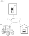
- the processing device 250 retrieves some reflection points corresponding to the three reflective portions 148a, 148b, and 148c from a plurality of reflection points indicated by the first sensor data output from the first LiDAR sensor 140A. For example, the processing device 250 may perform clustering on the point cloud indicated by the first sensor data based on point-to-point distances, and retrieves three clusters that are estimated to indicate the actual positional relationship and shapes of the reflective portions 148a, 148b, and 148c, as reflection points corresponding to the reflective portions 148a, 148b, and 148c.
- the first sensor data includes information about the luminance of each reflection point
- some reflection points constituting three clusters close to each other, of reflection points whose luminances exceed a threshold may be retrieved as reflection points corresponding to the three reflective portions 148a, 148b, and 148c.
- the processing device 250 determines a representative position of each of the reflective portions 148a, 148b, and 148c based on the coordinate values of the plurality of retrieved reflection points corresponding to the reflective portions 148a, 148b, and 148c.
- the representative position of each reflective portion may, for example, be the average value or middle value of the positions of the plurality of reflection points corresponding to the reflective portion.
- the representative position of each reflective portion is hereinafter referred to as the "position" of the reflective portion.
- a relationship between the positions of the three reflective portions 148a, 148b, and 148c, and a reference position (e.g., the position of a point from which the beam is emitted) of the second LiDAR sensor 140B and the front direction D2 of the second LiDAR sensor 140B, is known, and data indicating the relationship is previously stored in the storage.
- the processing device 250 determines the reference position of the second LiDAR sensor 140B and the front direction D2 in the first sensor coordinate system based on the data indicating the relationship, and the positions of the three reflective portions 148a, 148b, and 148c determined based on the first sensor data.
- the processing device 250 can, for example, determine the reference position of the second LiDAR sensor 140B and the front direction D2 in the first sensor coordinate system using a method described below.
- the processing device 250 calculates and determines the position of the median point of the triangle formed by the positions P1, P2, and P3 of the three reflective portions 148a, 148b, and 148c determined based on the first sensor data, and the vector normal to the plane including the positions P1, P2, and P3.
- the processing device 250 determines a position that is located at a predetermined distance away from the determined median point of the triangle in a predetermined direction (e.g., the direction of a vector from the point P1 toward the median point) as the reference position of the second LiDAR sensor 140B.
- the processing device 250 also determines the direction of the determined vector normal to the plane as the front direction D2 of the second LiDAR sensor 140B.
- the processing device 250 can estimate the position and orientation angles (roll, pitch, and yaw) of the second LiDAR sensor 140B.
- the method for estimating the pose of the second LiDAR sensor 140B depends on a relationship in relative position and orientation between the second LiDAR sensor 140B and the marker member 148. For example, if the direction of the line normal to the plane including the three points P1, P2, and P3 of the marker member 148 deviates from the front direction D2 of the second LiDAR sensor 140B, the pose of the second LiDAR sensor 140B relative to the first LiDAR sensor 140A is estimated, taking the deviation into account.
- the marker member 148 may be provided at a position away from the second LiDAR sensor 140B.
- the positional relationship between the marker member 148 and the second LiDAR sensor 140B, and the sizes of the reflective portions, may be adjusted as appropriate. If the first LiDAR sensor 140A and the second LiDAR sensor 140B are located too far away from each other, it may be difficult to detect the reflective portions. Conversely, if the first LiDAR sensor 140A and the second LiDAR sensor 140B are too close to each other, the reflective portions may be located out of the detection range of the first LiDAR sensor 140A. In such cases, by changing the distance between the marker member 148 and the second LiDAR sensor 140B or the sizes of the reflective portions, the reflective portions can be appropriately detected.
- FIG. 4 is a diagram illustrating another example of the marker member 148.
- the marker member 148 is mounted on the implement 300 separately from the second LiDAR sensor 140B.
- the marker member 148 of FIG. 4 has a flat plate 148k supported by two support posts 148j.
- the three reflective portions 148a, 148b, and 148c are provided on the flat plate 148k.
- a reflective material e.g., a retroreflective material
- the position of the marker member 148 can be changed as appropriate. Even in the case in which the marker member 148 thus configured is used, the pose of the second LiDAR sensor 140B can be estimated by a process similar to that of the example of FIG. 3 .
- the processing device 250 recognizes the three reflective portions 148a, 148b, and 148c of the marker member 148 provided in the vicinity of the second LiDAR sensor 140B based on the first sensor data output from the first LiDAR sensor 140A.
- the processing device 250 estimates the pose of the second LiDAR sensor 140B in a coordinate system fixed to the first LiDAR sensor 140A and the work vehicle 100 based on the recognized positions of the three reflective portions 148a, 148b, and 148c.
- the processing device 250 outputs data indicating the estimated pose of the second LiDAR sensor 140B.
- the processing device 250 may output and store the data indicating the pose of the second LiDAR sensor 140B to the storage.
- the processing device 250 may transmit the data indicating the pose of the second LiDAR sensor 140B to an external computer.
- the processing device 250 may be configured to convert the second sensor data output from the second LiDAR sensor 140B into data represented in a vehicle coordinate system fixed to the work vehicle 100 based on the estimated pose of the second LiDAR sensor 140B, and output the resultant data.
- the processing device 250 may perform the coordinate conversion by performing a matrix operation for translating and rotating the coordinate values of the reflection points in the second sensor data based on the estimate position and orientation angles of the second LiDAR sensor 140B.
- the processing device 250 can generate point cloud data in the vehicle coordinate system by such coordinate conversion.
- the processing device 250 may generate combined point cloud data using not only the second sensor data but also the first sensor data.
- the processing device 250 may convert the second sensor data into data represented in the vehicle coordinate system based on the estimated pose of the second LiDAR sensor 140B, and generate and output point cloud data based on the first sensor data and the converted second sensor data.
- the processing device 250 can convert the first sensor data represented by the first sensor coordinate system into data represented by the vehicle coordinate system. Alternatively, the processing device 250 may process the first sensor coordinate system as the vehicle coordinate system. In that case, the process of coordinate conversion of the first sensor data is not required.
- the processing device 250 can generate point cloud data by combining the first sensor data represented by the vehicle coordinate system and the second sensor data.
- the processing device 250 may combine data obtained by excluding, from the first sensor data, data of regions corresponding to the implement 300, the second LiDAR sensor 140B, and the marker member 148, with the converted second sensor data, to generate point cloud data.
- the shapes of the implement 300, the second LiDAR sensor 140B, and the marker member 148, and the positional relationship between the implement 300, the second LiDAR sensor 140B, and the marker member 148, and the first LiDAR sensor 140A, are known.
- the processing device 250 can determine and exclude, from the first sensor data, data of regions corresponding to the implement 300, the second LiDAR sensor 140B, and the marker member 148.
- the processing device 250 can determine and exclude, from the first sensor data, data of regions corresponding to the implement 300, the second LiDAR sensor 140B, and the marker member 148.
- the processing device 250 itself generates point cloud data based on the first sensor data and the second sensor data.
- another computer may instead generate the point cloud data.
- the processing device 250 transmits data indicating the estimated pose of the second LiDAR sensor 140B, and the second sensor data (and, in some cases, the first sensor data), to the second computer.
- the second computer can generate point cloud data indicating the distribution of objects on the ground around the work vehicle 100 based on the data received from the processing device 250.
- the second LiDAR sensor 140B transmits the generated second sensor data to the processing device 250 by, for example, wireless communication.
- the second LiDAR sensor 140B may optionally perform downsampling on the second sensor data, and transmit the second sensor data whose data amount has been compressed to the processing device 250. This also holds true for the first LiDAR sensor 140A.
- the sensing system of this embodiment may further include a storage that stores an environmental map.
- the storage may be internal or external to the processing device 250.
- the environmental map represents the positions or regions of objects existing in an environment in which the work vehicle 100 travels using a predetermined coordinate system.
- the processing device 250 is configured to perform localization on the work vehicle 100 by the following steps (S1)-(S4).
- the processing device 250 may be configured to repeatedly perform the steps (S1)-(S4) while the work vehicle 100 is traveling, to estimate the pose of the work vehicle 100 at short time intervals (e.g., at least once per second).
- the processing device 250 may transmit data indicating the estimated pose of the work vehicle 100 to the controller that controls the automatic traveling of the work vehicle 100.
- the controller may control steering and speed based on the estimated pose of the work vehicle 100 and a preset target path. As a result, the automatic traveling of the work vehicle 100 can be embodied.
- the pose of the second LiDAR sensor 140B is estimated based on the first sensor data output from the first LiDAR sensor 140A.
- the pose of the second LiDAR sensor 140B may be estimated using other types of sensing devices.
- FIG. 5 is a diagram illustrating another example sensing system.
- a camera 120 is provided instead of the first LiDAR sensor 140A of FIG. 1 .
- the camera 120 includes an image sensor to output image data as first sensor data.
- the camera 120 or the image sensor serves as a first range sensor.
- FIG. 5 illustrates an imaging range 40 of the camera 120 with a dotted line.
- a marker member 148 has a characteristic luminance distribution or color distribution.
- the processing device 250 estimates the pose of the LiDAR sensor 140B relative to the camera 120 based on the luminance distribution or color distribution of a region corresponding to the marker member 148 in the image indicated by the first sensor data.
- distances to the reflective portions 148a, 148b, and 148c can be estimated from the sizes of the reflective portions 148a, 148b, and 148c, respectively, recognized from the image data.
- the processing device 250 can estimate the position and orientation angles of the LiDAR sensor 140B as viewed from the camera 120.
- the marker member 148 may include a plurality of portions (e.g., at least three portions) with different colors instead of the reflective portions 148a, 148b, and 148c, which have a high light reflectance.
- FIG. 6 is a diagram illustrating an example of the marker member 148 including a plurality of portions with different colors.
- the marker member 148 includes a flat plate 148k on which a color chart having a plurality of portions having different colors is provided.
- the processing device 250 can estimate distances to the portions based on the sizes and positional relationship of the plurality of portions having different colors in an image generated by the camera 120 imaging a scene including the marker member 148.
- the processing device 250 can estimate the pose of the second LiDAR sensor 140B based on the distances to the portions.
- the first GNSS receiver 110A is provided at an upper portion of the cabin 105.
- the second GNN receiver 110B is arranged on the implement 300 around the LiDAR sensor 140B with a space therebetween.
- the GNN receivers 110A and 110B may each be provided at a position different from that of FIG. 7 .
- the GNN receivers 110A and 110B may each include an antenna that receives signals from GNSS satellites, and a processor that calculates its own position based on the signals received by the antenna.
- the GNN receivers 110A and 110B each receive satellite signals transmitted from a plurality of GNSS satellites, and perform positioning based on the satellite signals.
- GNSS collectively refers to satellite-based positioning systems, such as the global positioning system (GPS), the quasi-zenith satellite system (QZSS, for example, Michibiki), GLONASS, Galileo, and BeiDou.
- GPS global positioning system
- QZSS quasi-zenith satellite system
- Galileo Galileo
- the processing device 250 may be connected to each of the GNN receivers 110A and 110B by wireless or wired communication.
- the processing device 250 estimates the pose of the LiDAR sensor 140B relative to the first GNSS receiver 110A based on satellite signals received from the first GNSS receiver 110A and satellite signals received by the at least three second GNN receivers 110B.
- the processing device 250 can calculate the position of each second GNN receiver 110B relative to the first GNSS receiver 110A by performing moving baseline processing where the first GNSS receiver 110A is a moving base, and the plurality of second GNN receiver 110B are a rover.
- a positional relationship between each second GNN receiver 110B and the LiDAR sensor 140B is known, and data indicating the positional relationship is stored in a storage.
- the processing device 250 can estimate the pose of the second LiDAR sensor 140B based on the calculated position of each second GNN receiver 110B and the known positional relationship between each second GNN receiver 110B and the LiDAR sensor 140B. It should be noted that the above process executed by the processing device 250 may be executed by a processor included in the first GNSS receiver 110A.
- FIG. 8 is a diagram for outlining a system according to an illustrative embodiment of the present disclosure.
- the system of FIG. 8 includes a work vehicle 100, a terminal device 400, and a management device 600.
- the terminal device 400 is a computer used by a user who remotely monitors the work vehicle 100.
- the management device 600 is a computer managed by an entity running the system.
- the work vehicle 100, the terminal device 400, and the management device 600 can communicate with each other through a network 80.
- FIG. 8 illustrates a single work vehicle 100, the system may include a plurality of work vehicles or other agricultural machines.
- the work vehicle 100 is a tractor.
- the work vehicle 100 can have an implement attached to its rear and/or its front. While performing agricultural work in accordance with a particular type of implement, the work vehicle 100 is able to travel inside a field.
- the work vehicle 100 may travel inside the field or outside the field with no implement being attached thereto.
- the work vehicle 100 has a self-driving function. In other words, the work vehicle 100 can travel by the action of a controller, rather than manually.
- the controller according to the present embodiment is provided inside the work vehicle 100, and is able to control both the speed and steering of the work vehicle 100.
- the work vehicle 100 can perform self-traveling outside the field (e.g., on roads) as well as inside the field.
- the work vehicle 100 includes a device usable for positioning or localization, such as a GNSS receiver or an LiDAR sensor. Based on the position of the work vehicle 100 and information on a target path, the controller of the work vehicle 100 causes the work vehicle 100 to automatically travel. In addition to controlling the travel of the work vehicle 100 , the controller also controls the operation of the implement. As a result, while automatically traveling inside the field, the work vehicle 100 is able to perform agricultural work by using the implement. In addition, the work vehicle 100 is able to automatically travel along the target path on a road outside the field (e.g., an agricultural road or a general road).
- a road outside the field e.g., an agricultural road or a general road.
- the work vehicle 100 travels while generating, along the target path, a local path along which the work vehicle 100 can avoid an obstacle, based on data output from a sensing device such as a camera or a LiDAR sensor.
- a sensing device such as a camera or a LiDAR sensor.
- the work vehicle 100 may travel while generating a local path in substantially the same manner as described above, or may perform an operation of traveling along the target path without generating a local path and halting when an obstacle is detected.
- the management device 600 is a computer to manage the agricultural work performed by the work vehicle 100 .
- the management device 600 may be, for example, a server computer that performs centralized management on information regarding the field on the cloud and supports agriculture by use of the data on the cloud.
- the management device 600 for example, creates a work plan for the work vehicle 100 and performs path planning for the work vehicle 100 in accordance with the work plan.
- the management device 600 may further generate or edit an environment map based on data collected by the work vehicle 100 or any other movable body by use of the sensing device such as a LiDAR sensor.
- the management device 600 transmits data on the work plan, the target path and the environment map thus generated to the work vehicle 100.
- the work vehicle 100 automatically moves and performs agricultural work based on the data.
- the terminal device 400 is a computer that is used by a user who is located away from the work vehicle 100.
- the terminal device 400 is used to remotely monitor the work vehicle 100 or remotely operate the work vehicle 100.
- the terminal device 400 can display, on a display device, video captured by at least one camera (imaging device) provided in the work vehicle 100.
- the user can check a situation around the work vehicle 100 by viewing the video, and sends a stop or start instruction to the work vehicle 100.
- FIG. 9 is a side view schematically showing an example of the work vehicle 100 and an example of implement 300 linked to the work vehicle 100.
- the work vehicle 100 according to the present embodiment can operate both in a manual driving mode and a self-driving mode. In the self-driving mode, the work vehicle 100 is able to perform unmanned travel.
- the work vehicle 100 of FIG. 9 includes a vehicle body 101, a prime mover (engine) 102, and a transmission 103.
- the vehicle body 101 is provided with tire-mounted wheels 104 and a cabin 105.
- the wheels 104 include a pair of front wheels 104F and a pair of rear wheels 104R.
- a driver's seat 107, a steering device 106, an operation terminal 200, and switches for operations are provided in the cabin 105.
- One or both of the front wheel 104F and the rear wheel 104R may be replaced with a plurality of wheels to which a continuous track is attached (crawler) instead of a tire-mounted wheel.
- the work vehicle 100 includes a plurality of sensing devices that sense surroundings of the work vehicle 100.
- the sensing devices include a camera 120, a first LiDAR sensor 140A, and a plurality of obstacle sensors 130.
- a second LiDAR sensor 140B and a marker member 148 are mounted on an implement 300.
- the camera 120 captures an image of an environment around the work vehicle 100 to generate image data.
- the work vehicle 100 may be provided with a plurality of cameras 120.
- An image obtained by the camera 120 may be transmitted to the terminal device 400, which performs remote monitoring.
- the image may be used to monitor the work vehicle 100 during unmanned driving.
- the camera 120 may also be used to generate images for recognizing surrounding objects or obstacles on the ground, white lines, signs, displays, and the like when the work vehicle 100 travels on roads (agricultural roads or general roads) outsides the field.
- the first LiDAR sensor 140A is arranged on the cabin 105.
- the second LiDAR sensor 140B is arranged on the implement 300.
- the first LiDAR sensor 140A and the second LiDAR sensor 140B may each be provided at a position different from that illustrated in the figures.
- the first LiDAR sensor 140A and the second LiDAR sensor 140B each repeatedly output first sensor data indicating distances to and directions of measurement points of objects existing in a surrounding environment, or the two-dimensional or three-dimensional coordinate values of the measurement points, while the work vehicle 100 is traveling.
- the first sensor data output from the first LiDAR sensor 140A and the second sensor data output from the second LiDAR sensor 140B are processed by a processing device in the work vehicle 100.
- the processing device estimates the pose of the second LiDAR sensor 140B relative to the first LiDAR sensor 140A based on the first sensor data generated by the first LiDAR sensor 140A sensing a region including the marker member 148.
- the processing device converts the second sensor data into data represented by a vehicle coordinate system fixed to the work vehicle 100, based on the estimated pose of the second LiDAR sensor 140B. Based on the converted second sensor data, or by combining the converted the converted second sensor data with the first sensor data, the processing device generates point cloud data in the vehicle coordinate system.
- the processing device can perform localization on the work vehicle 100 by performing matching between the point cloud data and an environmental map.
- the processing device can also, for example, generate or edit an environmental map using an algorithm such as simultaneous localization and mapping (SLAM).
- SLAM simultaneous localization and mapping
- the work vehicle 100 and the implement 300 may include a plurality of LiDAR sensors arranged at different positions and different orientations.
- the plurality of obstacle sensors 130 shown in FIG. 9 are provided at the front and the rear of the cabin 105.
- the obstacle sensors 130 may be disposed at other positions.
- one or more obstacle sensors 130 may be disposed at any position at the sides, the front or the rear of the vehicle body 101.
- the obstacle sensors 130 may include, for example, a laser scanner or an ultrasonic sonar.
- the obstacle sensors 130 may be used to detect obstacles in the surroundings of the work vehicle 100 during self-traveling to cause the work vehicle 100 to halt or detour around the obstacles.
- the LiDAR sensor 140 may be used as one of the obstacle sensors 130.
- the work vehicle 100 further includes a GNSS unit 110.
- the GNSS unit 110 includes a GNSS receiver.
- the GNSS receiver may include an antenna to receive a signal(s) from a GNSS satellite(s) and a processor to calculate the position of the work vehicle 100 based on the signal(s) received by the antenna.
- the GNSS unit 110 receives satellite signals transmitted from the plurality of GNSS satellites, and performs positioning based on the satellite signals.
- the GNSS unit 110 is disposed above the cabin 105, it may be disposed at any other position.
- the GNSS unit 110 may include an inertial measurement unit (IMU). Signals from the IMU can be used to complement position data.
- the IMU can measure a tilt or a small motion of the work vehicle 100.
- the data acquired by the IMU can be used to complement the position data based on the satellite signals, so as to improve the performance of positioning.
- the controller of the work vehicle 100 may utilize, for positioning, the sensing data acquired by the sensing devices such as the cameras 120 or the LIDAR sensor 140, in addition to the positioning results provided by the GNSS unit 110.
- the position and the orientation of the work vehicle 100 can be estimated with a high accuracy based on data that is acquired by the cameras 120 or the LiDAR sensor 140 and on an environment map that is previously stored in the storage.
- By correcting or complementing position data based on the satellite signals using the data acquired by the cameras 120 or the LiDAR sensor 140 it becomes possible to identify the position of the work vehicle 100 with a higher accuracy.
- the prime mover 102 may be a diesel engine, for example. Instead of a diesel engine, an electric motor may be used.
- the transmission 103 can change the propulsion and the moving speed of the work vehicle 100 through a speed changing mechanism.
- the transmission 103 can also switch between forward travel and backward travel of the work vehicle 100.
- the steering device 106 includes a steering wheel, a steering shaft connected to the steering wheel, and a power steering device to assist in the steering by the steering wheel.
- the front wheels 104F are the wheels responsible for steering, such that changing their angle of turn (also referred to as "steering angle") can cause a change in the traveling direction of the work vehicle 100.
- the steering angle of the front wheels 104F can be changed by manipulating the steering wheel.
- the power steering device includes a hydraulic device or an electric motor to supply an assisting force to change the steering angle of the front wheels 104F.
- the steering angle may be automatically adjusted by the power of the hydraulic device or the electric motor.
- a linkage device 108 is provided at the front of the vehicle body 101.
- the linkage device 108 may include, e.g., a three-point linkage (also referred to as a "three-point link” or a "three-point hitch"), a PTO (Power Take Off) shaft, a universal joint, and a communication cable.
- the linkage device 108 allows the implement 300 to be attached to, or detached from, the work vehicle 100.
- the linkage device 108 is able to raise or lower the three-point link with a hydraulic device, for example, thus changing the position and/or attitude of the implement 300.
- motive power can be sent from the work vehicle 100 to the implement 300 via the universal joint.
- the linkage device may also be provided at a rear portion of the vehicle body 101. In that case, an implement can be connected at the back of the work vehicle 100.
- FIG. 10 is a block diagram showing an example configuration of the work vehicle 100 and the implement 300.
- the work vehicle 100 and the implement 300 can communicate with each other via a communication cable that is included in the linkage device 108.
- the work vehicle 100 is able to communicate with the terminal device 400 and the management device 600 via the network 80.
- the work vehicle 100 in the example of FIG. 10 includes sensors 150 to detect the operating status of the work vehicle 100, a control system 160, a communicator 190, operation switches 210, and a drive device 240. These component elements are communicably connected to each other via a bus.
- the GNSS unit 110 includes a GNSS receiver 111, an RTK receiver 112, an inertial measurement unit (IMU) 115, and a processing circuit 116.
- the sensors 150 include a steering wheel sensor 152, an steering angle sensor 154, and a wheel axis sensor 156.
- the control system 160 includes a storage 170 and a controller 180.
- the controller 180 includes a plurality of electronic control units (ECU) 181 to 184.
- the implement 300 includes a drive device 340, a controller 380, a communicator 390, and a second LiDAR sensor 140B.
- FIG. 10 shows component elements which are relatively closely related to the operations of self-driving by the work vehicle 100, while other components are omitted from illustration.
- the GNSS receiver 111 in the GNSS unit 110 receives satellite signals transmitted from the plurality of GNSS satellites and generates GNSS data based on the satellite signals.
- the GNSS data is generated in a predetermined format such as, for example, the NMEA-0183 format.
- the GNSS data may include, for example, the identification number, the angle of elevation, the angle of direction, and a value representing the reception strength of each of the satellites from which the satellite signals are received.
- the GNSS unit 110 shown in FIG. 10 may be configured to perform positioning of the work vehicle 100 by utilizing an RTK (Real Time Kinematic)-GNSS, for example.
- FIG. 11 is a conceptual diagram showing an example of the work vehicle 100 performing positioning based on the RTK-GNSS.
- the reference station 60 may be disposed near the field where the work vehicle 100 performs tasked travel (e.g., at a position within 10 km of the work vehicle 100).
- the reference station 60 generates a correction signal of, for example, an RTCM format based on the satellite signals received from the plurality of GNSS satellites 50, and transmits the correction signal to the GNSS unit 110.
- the RTK receiver 112 which includes an antenna and a modem, receives the correction signal transmitted from the reference station 60 . Based on the correction signal, the processing circuit 116 of the GNSS unit 110 corrects the results of the positioning performed by use of the GNSS receiver 111 .
- Use of the RTK-GNSS enables positioning with an accuracy on the order of several centimeters of errors, for example. Positional information including latitude, longitude, and altitude information is acquired through the highly accurate positioning by the RTK-GNSS.
- the GNSS unit 110 calculates the position of the work vehicle 100 as frequently as, for example, one to ten times per second.
- the positioning method is not limited to being performed by use of an RTK-GNSS; any arbitrary positioning method (e.g., an interferometric positioning method or a relative positioning method) that provides positional information with the necessary accuracy can be used.
- positioning may be performed by utilizing a VRS (Virtual Reference Station) or a DGPS (Differential Global Positioning System).
- VRS Virtual Reference Station
- DGPS Different Global Positioning System
- positional information with the necessary accuracy can be obtained without the use of the correction signal transmitted from the reference station 60
- positional information may be generated without using the correction signal.
- the GNSS unit 110 does not need to include the RTK receiver 112.
- the position of the work vehicle 100 is estimated by another method with no use of the signal from the RTK receiver 112.
- the position of the work vehicle 100 may be estimated by matching the data output from the LiDAR sensors 140A and 140B and/or the cameras 120 against a highly accurate environment map.
- the GNSS unit 110 further includes the IMU 115.
- the IMU 115 may include a 3-axis accelerometer and a 3-axis gyroscope.
- the IMU 115 may include a direction sensor such as a 3-axis geomagnetic sensor.
- the IMU 115 functions as a motion sensor which can output signals representing parameters such as acceleration, velocity, displacement, and attitude of the work vehicle 100 .
- the processing circuit 116 can estimate the position and orientation of the work vehicle 100 with a higher accuracy.
- the signal that is output from the IMU 115 may be used for the correction or complementation of the position that is calculated based on the satellite signals and the correction signal.
- the IMU 115 outputs a signal more frequently than the GNSS receiver 111. Utilizing this signal that is output highly frequently, the processing circuit 116 allows the position and orientation of the work vehicle 100 to be measured more frequently (e.g., about 10 Hz or above). Instead of the IMU 115 , a 3-axis accelerometer and a 3-axis gyroscope may be separately provided. The IMU 115 may be provided as a separate device from the GNSS unit 110 .
- the cameras 120 are imagers that image the surrounding environment of the work vehicle 100.
- Each of the cameras 120 includes an image sensor such as a CCD (Charge Coupled Device) or a CMOS (Complementary Metal Oxide Semiconductor), for example.
- each camera 120 may include an optical system including one or more lenses and a signal processing circuit.
- the cameras 120 image the surrounding environment of the work vehicle 100 , and generate image data (e.g., motion picture data).
- the cameras 120 are able to capture motion pictures at a frame rate of 3 frames/second (fps: frames per second) or greater, for example.
- the images generated by the cameras 120 may be used by a remote supervisor to check the surrounding environment of the work vehicle 100 with the terminal device 400, for example.
- the images generated by the cameras 120 may also be used for the purpose of positioning and/or detection of obstacles.
- a single camera 120 may be provided, or a plurality of cameras 120 may be provided at different positions on the work vehicle 100.
- a visible camera(s) to generate visible light images and an infrared camera(s) to generate infrared images may be separately provided. Both of a visible camera(s) and an infrared camera(s) may be provided as cameras for generating images for monitoring purposes.
- the infrared camera(s) may also be used for detection of obstacles at nighttime.
- the camera(s) 120 may be a stereo camera. The stereo camera can be used to obtain a distance image indicating a distance distribution in the imaging range.
- the obstacle sensors 130 detect objects existing in the surroundings of the work vehicle 100.
- Each of the obstacle sensors 130 may include a laser scanner or an ultrasonic sonar, for example.
- the obstacle sensor 130 When an object exists at a position within a predetermined distance from one of the obstacle sensors 130, the obstacle sensor 130 outputs a signal indicating the presence of the obstacle.
- the plurality of obstacle sensors 130 may be provided at different positions on the work vehicle 100.
- a plurality of laser scanners and a plurality of ultrasonic sonars may be disposed at different positions on the work vehicle 100. Providing such a great number of obstacle sensors 130 can reduce blind spots in monitoring obstacles in the surroundings of the work vehicle 100.
- the steering wheel sensor 152 measures the angle of rotation of the steering wheel of the work vehicle 100.
- the steering angle sensor 154 measures the angle of turn of the front wheels 104F, which are the wheels responsible for steering. Measurement values by the steering wheel sensor 152 and the steering angle sensor 154 are used for steering control by the controller 180.
- the wheel axis sensor 156 measures the rotational speed, i.e., the number of revolutions per unit time, of a wheel axis that is connected to the wheels 104.
- the wheel axis sensor 156 may be a sensor including a magnetoresistive element (MR), a Hall generator, or an electromagnetic pickup, for example.
- the wheel axis sensor 156 outputs a numerical value indicating the number of revolutions per minute (unit: rpm) of the wheel axis, for example.
- the wheel axis sensor 156 is used to measure the speed of the work vehicle 100.
- the drive device 240 includes various types of devices required to cause the work vehicle 100 to travel and to drive the implement 300.
- the prime mover 102 may include an internal combustion engine such as, for example, a diesel engine.
- the drive device 240 may include an electric motor for traction instead of, or in addition to, the internal combustion engine.
- the storage 170 includes one or more storage mediums such as a flash memory or a magnetic disc.
- the storage 170 stores various data that is generated by the GNSS unit 110, the cameras 120, the obstacle sensors 130, the LiDAR sensor 140, the sensors 150, and the controller 180.
- the data that is stored by the storage 170 may include map data on the environment where the work vehicle 100 travels (environment map), data on a target path for self-driving, and data indicating a positional relationship between the second LiDAR sensor 140B and the marker member 148.
- the environment map includes information on a plurality of fields where the work vehicle 100 performs agricultural work and roads around the fields.
- the environment map and the target path may be generated by a processor in the management device 600.
- the controller 180 may have the function of generating or editing the environmental map and the target path.
- the storage 170 also stores a computer program(s) to cause each of the ECUs in the controller 180 to perform various operations described below.
- a computer program(s) may be provided to the work vehicle 100 via a storage medium (e.g., a semiconductor memory, an optical disc, etc.) or through telecommunication lines (e.g., the Internet).
- a computer program(s) may be marketed as commercial software.
- the controller 180 includes the plurality of ECUs.
- the plurality of ECUs include, for example, the ECU 181 for speed control, the ECU 182 for steering control, the ECU 183 for implement control, and the ECU 184 for self-driving control.
- the ECU 181 controls the prime mover 102, the transmission 103 and brakes included in the drive device 240, thus controlling the speed of the work vehicle 100.
- the ECU 182 controls the hydraulic device or the electric motor included in the steering device 106 based on a measurement value of the steering wheel sensor 152, thus controlling the steering of the work vehicle 100.
- the ECU 183 controls the operations of the three-point link, the PTO shaft and the like that are included in the linkage device 108. Also, the ECU 183 generates a signal to control the operation of the implement 300, and transmits this signal from the communicator 190 to the implement 300.
- the ECU 184 serves as the above processing device.
- the ECU 184 performs computation and control for achieving self-driving based on data output from the GNSS unit 110, the cameras 120, the obstacle sensors 130, the first LiDAR sensor 140A, the sensors 150, and the second LiDAR sensor 140B.
- the ECU 184 specifies the position of the work vehicle 100 based on the data output from at least one of the GNSS unit 110, the cameras 120 and the LiDAR sensors 140A and 140B.
- the ECU 184 may determine the position of the work vehicle 100 based only on the data output from the GNSS unit 110.
- the ECU 184 may estimate the position of the work vehicle 100 based on data output from the LiDAR sensors 140A and 140B. For example, the ECU 184 may perform localization on the work vehicle 100 by performing matching between data output from the LiDAR sensors 140A and 140B and an environmental map. During self-driving, the ECU 184 performs computation necessary for the work vehicle 100 to travel along a predetermined target path, based on the estimated position of the work vehicle 100. The ECU 184 sends the ECU 181 a command to change the speed, and sends the ECU 182 a command to change the steering angle.
- an obstacle e.g., a tree or construction
- the ECU 181 controls the prime mover 102, the transmission 103 or the brakes to change the speed of the work vehicle 100.
- the ECU 182 controls the steering device 106 to change the steering angle.
- the controller 180 realizes self-driving.
- the controller 180 controls the drive device 240 based on the measured or estimated position of the work vehicle 100 and on the target path. As a result, the controller 180 can cause the work vehicle 100 to travel along the target path.
- the plurality of ECUs included in the controller 180 can communicate with each other in accordance with a vehicle bus standard such as, for example, a CAN (Controller Area Network). Instead of the CAN, faster communication methods such as Automotive Ethernet (registered trademark) may be used.
- a vehicle bus standard such as, for example, a CAN (Controller Area Network).
- CAN Controller Area Network
- faster communication methods such as Automotive Ethernet (registered trademark) may be used.
- the ECUs 181 to 184 are illustrated as individual blocks in FIG. 10 , the function of each of the ECU 181 to 184 may be implemented by a plurality of ECUs. Alternatively, an onboard computer that integrates the functions of at least some of the ECUs 181 to 184 may be provided.
- the controller 180 may include ECUs other than the ECUs 181 to 184, and any number of ECUs may be provided in accordance with functionality.
- Each ECU includes one or more processors.
- the communicator 190 is a device including a circuit communicating with the implement 300, the terminal device 400 and the management device 600.
- the communicator 190 includes circuitry to perform exchanges of signals complying with an ISOBUS standard such as ISOBUS-TIM, for example, between itself and the communicator 390 of the implement 300. This allows the implement 300 to perform a desired operation, or allows information to be acquired from the implement 300.
- the communicator 190 may also have the function of wirelessly communicating with the second LiDAR sensor 140B.
- Communication conforming to any wireless communication standard such as Wi-Fi (registered trademark), cellular mobile communication (e.g., 3G, 4G, or 5G), or Bluetooth (registered trademark), may be performed between the communicator 190 and the second LiDAR sensor 140B.
- the communicator 190 may further include an antenna and a communication circuit to exchange signals via the network 80 with communicators of the terminal device 400 and the management device 600.
- the network 80 may include a 3G, 4G, 5G, or any other cellular mobile communications network and the Internet, for example.
- the operation terminal 200 may be configured so as to be detachable from the work vehicle 100.
- a user who is at a remote place from the work vehicle 100 may manipulate the detached operation terminal 200 to control the operation of the work vehicle 100.
- the user may manipulate a computer on which necessary application software is installed, for example, the terminal device 400, to control the operation of the work vehicle 100.
- the drive device 340 in the implement 300 shown in FIG. 10 performs operations necessary for the implement 300 to perform predetermined work.
- the drive device 340 includes a device suitable for uses of the implement 300, for example, a hydraulic device, an electric motor, a pump or the like.
- the controller 380 controls the operation of the drive device 340.
- the controller 380 causes the drive device 340 to perform various operations.
- a signal that is in accordance with the state of the implement 300 can be transmitted from the communicator 390 to the work vehicle 100.
- FIG. 12 is a diagram schematically illustrating an example of an environment in which the work vehicle 100 travels.
- the work vehicle 100 performs predetermined work (e.g., mowing and pest controlling) using the implement 300 while traveling between a plurality of rows 20 of trees in an orchard (e.g., a grape orchard).
- an orchard e.g., a grape orchard
- the ECU 184 performs localization on the work vehicle 100 based on data from the first LiDAR sensor 140A and the second LiDAR sensor 140B.
- the ECU 184 initially generates an environmental map indicating the distribution of trunks of the tree rows 20 in all or a portion of an orchard by utilizing sensor data output from the LiDAR sensors 140A and 140B, and stores the environmental map into the storage 170.
- the environmental map generation is executed by repeatedly performing localization and generation of a local map.
- the ECU 184 repeatedly performs the operation of, based on sensor data repeatedly output from the LiDAR sensors 140A and 140B when the work vehicle 100 is traveling, detecting tree rows in an environment around the work vehicle 100 while performing localization, generating a local map indicating the distribution of the detected tree rows, and storing the local map into the storage 170.
- the ECU 184 generates an environmental map by joining together local maps generated while the work vehicle 100 is traveling in all or a part of an orchard.
- the environmental map is data in which the distribution of the tree rows 20 in the environment is stored in a form with which the tree rows 20 can be distinguished from other objects.
- the tree rows 20 may be used as a landmark for SLAM.
- the ECU 184 estimates the position of the work vehicle 100 by detecting the tree rows 20 in the surrounding environment based on sensor data repeatedly output from the LiDAR sensors 140A and 140B when the work vehicle 100 is traveling, and performing matching between the detected tree rows 20 and the environmental map.
- the ECU 184 controls the traveling of the work vehicle 100 based the estimated position of the work vehicle 100. For example, if the work vehicle 100 deviates from a target path set between two adjacent tree rows, the ECU 184 performs control so as to cause the ECU 182 to adjust the steering of the work vehicle 100 so that the work vehicle 100 approaches the target path. Such steering control may be performed based on the orientation of the work vehicle 100 in addition to the position of the work vehicle 100.
- FIG. 13A is a diagram schematically illustrating an example travel path of the work vehicle 100.
- the work vehicle 100 travels between a plurality of tree rows 20 in an orchard along a path 25 indicated by an arrow in FIG. 13A .
- FIG. 13A illustrates line segments included in the path 25 in straight line, paths along which the work vehicle 100 actually travels may include winding portions.
- the plurality of tree rows 20 are successively ordered from an end like a first tree row 20A, a second tree row 20B, a third tree row 20C, a fourth tree row 20D, and so on.
- FIG. 13A is a diagram schematically illustrating an example travel path of the work vehicle 100.
- the work vehicle 100 travels between a plurality of tree rows 20 in an orchard along a path 25 indicated by an arrow in FIG. 13A .
- FIG. 13A illustrates line segments included in the path 25 in straight line, paths along which the work vehicle 100 actually travels may include winding portions.
- the work vehicle 100 initially travels between the first tree row 20A and the second tree row 20B, and after that, turns to travel between the second tree row 20B and the third tree row 20C in the opposite direction. After having traveled between the second tree row 20B and the third tree row 20C, the work vehicle 100 turns to travel between the third tree row 20C and the fourth tree row 20D. Thereafter, by repeatedly performing a similar operation, the work vehicle 100 travels to the end of the path 25 between the final two tree rows. It should be noted that as illustrated in FIG. 13B , if adjacent tree rows are separated by a short distance, the work vehicle 100 may travel along every other row.
- the work vehicle 100 After having traveled between the final two tree rows, the work vehicle 100 travels along paths between tree rows on which the work vehicle 100 has not yet traveled, along every other row.
- the work vehicle 100 automatically performs such traveling while performing localization using the LiDAR sensors 140A and 140B.
- the GNSS unit 110 can receive GNSS signals, positioning may be performed based on the GNSS signals. For example, in the case of the path 25 illustrated in FIGS. 13A and 13B , when the work vehicle 100 changes directions, the work vehicle 100 is not hidden by leaves that block GNSS signals, and therefore, positioning can be performed based on GNSS signals.
- FIG. 14 is a flowchart showing an example operation of steering control to be performed by the controller 180 during self-driving.
- the controller 180 performs automatic steering by performing the operation from steps S121 to S125 shown in FIG. 14 .
- the speed of the work vehicle 100 may be maintained at a previously-set speed, for example.
- the controller 180 performs localization on the work vehicle 100 based on data output from the GNSS unit 110 or the LiDAR sensors 140A and 140B while the work vehicle 100 is traveling (step S121). A specific example process of localization is described below.
- the controller 180 calculates a deviation of the estimated position of the work vehicle 100 from a target path (step S122).
- the deviation represents the distance between the position of the work vehicle 100 and the target path at that moment.
- the controller 180 determines whether the calculated deviation in position exceeds the previously-set threshold or not (step S123). If the deviation exceeds the threshold, the controller 180 changes a control parameter of the steering device included in the drive device 240 so as to reduce the deviation, thus changing the steering angle (step S124). If the deviation does not exceed the threshold at step S123, the operation of step S124 is omitted.
- the controller 180 determines whether a command to end the operation has been received or not. The command to end the operation may be given when the user has instructed that self-driving be suspended through remote manipulations, or when the work vehicle 100 has arrived at the destination, for example.
- step S121 the control returns to step S121 and the controller 180 performs substantially the same operation based on a newly measured position of the work vehicle 100.
- the controller 180 repeats the operation from steps S121 to S125 until a command to end the operation is given.
- the aforementioned operation is executed by the ECUs 182 and 184 in the controller 180.
- the controller 180 controls the drive device 240 based only on the deviation between the position of the work vehicle 100 and the target path.
- a deviation in terms of directions may further be considered in the control.
- the controller 180 may change the control parameter of the steering device of the drive device 240 (e.g., steering angle) in accordance with the deviation.
- FIG. 15A is a diagram showing an example of the work vehicle 100 traveling along a target path P.
- FIG. 15B is a diagram showing an example of the work vehicle 100 at a position which is shifted rightward from the target path P.
- FIG. 15C is a diagram showing an example of the work vehicle 100 at a position which is shifted leftward from the target path P.
- FIG. 15D is a diagram showing an example of the work vehicle 100 oriented in an inclined direction with respect to the target path P.
- the pose, i.e., the position and orientation, of the work vehicle 100 as measured by the GNSS unit 110 is expressed as r(x,y, ⁇ ).
- (x,y) are coordinates representing the position of a reference point on the work vehicle 100 in an XY coordinate system, which is a two-dimensional coordinate system fixed to the globe.
- the reference point on the work vehicle 100 is at a position, on the cabin, where a GNSS antenna is disposed, but the reference point may be at any arbitrary position.
- ⁇ is an angle representing the measured orientation of the work vehicle 100.
- the target path P is shown parallel to the Y axis in the examples illustrated in these figures, the target path P may not necessarily be parallel to the Y axis, in general.
- the controller 180 maintains the steering angle and speed of the work vehicle 100 without changing them.
- the controller 180 changes the steering angle so that the traveling direction of the work vehicle 100 will be inclined leftward, thus bringing the work vehicle 100 closer to the path P.
- the controller 180 changes the steering angle so that the traveling direction of the work vehicle 100 will be inclined leftward, thus bringing the work vehicle 100 closer to the path P.
- the magnitude of the steering angle may be adjusted in accordance with the magnitude of a positional deviation ⁇ x, for example.
- the controller 180 changes the steering angle so that the traveling direction of the work vehicle 100 will be inclined rightward, thus bringing the work vehicle 100 closer to the path P.
- the steering angle may be adjusted in accordance with the magnitude of the positional deviation ⁇ x, for example.
- the controller 180 changes the steering angle so that the directional deviation ⁇ will become smaller.
- the magnitude of the steering angle may be adjusted in accordance with the magnitudes of the positional deviation ⁇ x and the directional deviation ⁇ , for example. For instance, the amount of change of the steering angle (which is in accordance with the directional deviation ⁇ ) may be increased as the absolute value of the positional deviation ⁇ x decreases.
- the steering angle will be changed greatly in order for the work vehicle 100 to return to the path P, so that the directional deviation ⁇ will inevitably have a large absolute value.
- the directional deviation ⁇ needs to become closer to zero. Therefore, it may be advantageous to introduce a relatively large weight (i.e., control gain) for the directional deviation ⁇ in determining the steering angle.
- control techniques such as PID control or MPC (Model Predictive Control) may be applied. Applying these control techniques will make for smoothness of the control of bringing the work vehicle 100 closer to the target path P.
- the controller 180 halts the work vehicle 100. At this point, the controller 180 may cause the buzzer 220 to present an alarm sound or may transmit an alert signal to the terminal device 400. In the case where the obstacle is avoidable, the controller 180 may control the drive device 240 such that the obstacle is avoided.
- step S121 in FIG. 14 Next, a specific example of the localization process of step S121 in FIG. 14 will be described.
- FIG. 16 is a flowchart illustrating a specific example of the process of step S121 in FIG. 14 .
- step S121 includes the processes of steps S141 to S146.
- the ECU 184 (processing device) of the controller 180 initially obtains the first sensor data and the second sensor data (step S141). Next, the ECU 184 determines the positions of a plurality of reflective portions of the marker member 148 based on the first sensor data (step S142). The plurality of reflective portions have a light reflectance higher than that of the other portions, including, for example, the reflective portions 148a, 148b, and 148c illustrated in FIG. 2 or 4 .
- the ECU 184 estimates the pose of the second LiDAR sensor 140B relative to the first LiDAR sensor 140A based on the positions of the plurality of reflective portions of the marker member 148, and a known positional relationship between the plurality of reflective portions and the second LiDAR sensor 140B (step S143).
- the ECU 184 converts the second sensor data into data in a coordinate system fixed to the work vehicle 100 based on the pose of the second LiDAR sensor 140B relative to the first LiDAR sensor 140A (step S144).
- the coordinate system fixed to the work vehicle 100 may, for example, be the same as that set for the first LiDAR sensor 140A.
- the ECU 184 combines the first sensor data and the converted second sensor data to generate point cloud data (step S145). At this time, the ECU 184 may exclude, from the first sensor data, data of points in regions corresponding to the implement 300, the second LiDAR sensor 140B, and the marker member 148, before combining the first sensor data and the second sensor data.
- the ECU 184 may generate point cloud data only based on the second sensor data that has been subjected to coordinate conversion. Next, the ECU 184 performs matching between the generated point cloud data and an environmental map stored in the storage 170, to determine the pose of the work vehicle 100 (step S146).
- the ECU 184 can perform localization on the work vehicle 100.
- the second LiDAR sensor 140B and the marker member 148 are mounted on the implement 300, separately from the first LiDAR sensor 140A provided on the work vehicle 100.
- the pose of the second LiDAR sensor 140B can be estimated based on the first sensor data obtained by the first LiDAR 140A sensing the marker member 148.
- the second sensor data can be converted into data in a coordinate system fixed to the work vehicle 100, and the data can be used in localization.
- localization can be performed even when a large-size implement 300 is attached to the work vehicle 100.
- the above process is not limited to localization, and may be applied to the case in which obstacle detection is performed using the LiDAR sensors 140A and 140B.
- the LiDAR sensors 140A and 140B are used, sensors that measure distances using other techniques may be used.
- techniques similar to the example in which the camera 120 of FIG. 5 is used or the plurality of GNN receivers 110A and 110B of FIG. 7 are used may be applied.
- other range sensors such as a stereo camera and ToF camera may be used.
- sensing system is not limited to the agricultural work vehicle 100, and may be used in work vehicles for other applications such as civil engineering work, construction work, or snow removal work.
- a sensing system comprising:
- the second range sensor includes a mounting device that mounts the second range sensor on the implement, and is external to the implement.
- the processing device is configured to estimate the pose of the second range sensor relative to the first range sensor based on the first sensor data, and information indicating a relationship in position and orientation between the second range sensor and the marker member.
- the sensing system according to any of items 1 to 4, wherein the processing device is configured to convert second sensor data output from the second range sensor into data represented by a coordinate system fixed to the work vehicle based on the estimated pose, and output the data.
- the sensing system wherein the processing device is configured to convert the second sensor data into data represented by a coordinate system fixed to the work vehicle based on the estimated pose, and generate and output point cloud data based on the first sensor data and the converted second sensor data.
- the sensing system wherein the processing device is configured to combine data obtained by excluding, from the first sensor data, data of a region corresponding to the implement and the second range sensor, with the converted second sensor data, to generate the point cloud data.
- the sensing system according to any of items 1 to 9, further comprising:
- An agricultural machine comprising the sensing system according to any of items 1 to 11.
- a sensing device that is used as the second range sensor in the sensing system according to any of items 1 to 11, the sensing device comprising:
- a sensing system comprising:
- a sensing system comprising:
- the technique of the present disclosure is applicable to a work vehicle that travels while performing work using an implement.
- the technique of the present disclosure is applicable to a work vehicle such as a tractor that automatically travels while performing agricultural work with an implement attached to a front or rear portion thereof.
Landscapes
- Engineering & Computer Science (AREA)
- Physics & Mathematics (AREA)
- Radar, Positioning & Navigation (AREA)
- Remote Sensing (AREA)
- General Physics & Mathematics (AREA)
- Computer Networks & Wireless Communication (AREA)
- Electromagnetism (AREA)
- Life Sciences & Earth Sciences (AREA)
- Aviation & Aerospace Engineering (AREA)
- Automation & Control Theory (AREA)
- Computer Vision & Pattern Recognition (AREA)
- Theoretical Computer Science (AREA)
- Mechanical Engineering (AREA)
- Soil Sciences (AREA)
- Environmental Sciences (AREA)
- Optical Radar Systems And Details Thereof (AREA)
- Control Of Position, Course, Altitude, Or Attitude Of Moving Bodies (AREA)
Abstract
Description
- The present disclosure relates to sensing systems, agricultural machines, and sensing devices.
- Research and development of smart agriculture that employs information and communication technology (ICT) and the Internet of things (IoT), as the next-generation agriculture, are under way. Automated and unmanned operations of agricultural machines such as tractors, rice transplanters, and combine harvesters used in fields have been being studied and developed. For example, work vehicles that perform agricultural work while automatically traveling within fields using a positioning system such as a global navigation satellite system (GNSS) that can perform precise positioning have been put into practice.
- Meanwhile, work vehicles that automatically travel using a range sensor such as light detection and ranging (LiDAR) have also been being developed. For example,
Patent Document 1 describes an example of a work vehicle that recognizes crop rows in a field using a LiDAR sensor, and automatically travels between crop rows. Patent Document 2 describes an example of a work vehicle that automatically travels along a target path set in a field while detecting obstacles using a LiDAR sensor. -
- Patent Document 1:
Japanese Laid-Open Patent Publication No. 2019-154379 - Patent Document 2:
Japanese Laid-Open Patent Publication No. 2019-170271 - In work vehicles that automatically travel while sensing a surrounding environment using a range sensor such as a LiDAR sensor, the sensing may be hampered by an implement connected to the work vehicle. For example, when an implement is connected to the front portion of a work vehicle, blind spots occur in the sensing range in front of the work vehicle, so that the sensing is hampered.
- The present disclosure provides techniques for reducing the hampering of sensing due to an implement.
- A sensing system according to an embodiment of the present disclosure includes a first range sensor mounted on a work vehicle, a second range sensor mounted on an implement connected to the work vehicle, a marker member located in a sensing range of the first range sensor, and a processing device. The processing device is configured to estimate a pose of the second range sensor relative to the first range sensor based on first sensor data generated by the first range sensor sensing a region including the marker member, and outputs data indicating the estimated pose.
- General or specific aspects of the present disclosure may be implemented using devices, systems, methods, integrated circuits, computer programs, non-transitory computer-readable storage mediua, or any combination thereof. The computer-readable storage media may be inclusive of volatile storage media or non-volatile storage media. The devices may each include a plurality of devices. In the case where the devices each include two or more devices, the two or more devices may be included within a single apparatus, or divided over two or more separate apparatuses.
- According to the embodiments of the present disclosure, it is possible to avoid the hampering of sensing by an implement.
-
- [
FIG. 1] FIG. 1 is a side view schematically illustrating an agricultural machine according to an illustrative embodiment of the present disclosure. - [
FIG. 2] FIG. 2 is a diagram illustrating an example configuration of a marker member. - [
FIG. 3] FIG. 3 is a diagram for describing a process of estimating a pose of a second LiDAR sensor relative to a first LiDAR sensor. - [
FIG. 4] FIG. 4 is a diagram illustrating another example marker member. - [
FIG. 5] FIG. 5 is a diagram illustrating another example sensing system. - [
FIG. 6] FIG. 6 is a diagram illustrating an example of a marker member having a plurality of portions having different colors. - [
FIG. 7] FIG. 7 is a diagram illustrating still another example sensing system. - [
FIG. 8] FIG. 8 is a diagram for outlining a system according to an illustrative embodiment of the present disclosure. - [
FIG. 9] FIG. 9 is a side view schematically illustrating an example of a work vehicle, and an implement connected to the work vehicle. - [
FIG. 10] FIG. 10 is a block diagram illustrating an example configuration of a work vehicle and an implement. - [
FIG. 11] FIG. 11 is a conceptual diagram illustrating an example of a work vehicle performing positioning based on RTK-GNSS. - [
FIG. 12] FIG. 12 is a diagram schematically illustrating an example of an environment in which a work vehicle travels. - [
FIG. 13A] FIG. 13A is a diagram schematically illustrating an example travel path of a work vehicle. - [
FIG. 13B] FIG. 13B is a diagram schematically illustrating another example travel path of a work vehicle. - [
FIG. 14] FIG. 14 is a flowchart illustrating an example operation of steering control during self-driving performed by a controller. - [
FIG. 15A] FIG. 15A is a diagram illustrating an example of a work vehicle that travels along a target path. - [
FIG. 15B] FIG. 15B is a diagram illustrating an example of a work vehicle that is located at a position away from and to the right of a target path. - [
FIG. 15C] FIG. 15C is a diagram illustrating an example of a work vehicle that is located at a position away from and to the left of a target path. - [
FIG. 15D] FIG. 15D is a diagram illustrating an example of a work vehicle that faces in a direction tilted with respect to a target path. - [
FIG. 16] FIG. 16 is a flowchart illustrating a specific example of a localization process. - As used herein, the term "work vehicle" refers to a vehicle used to perform work at work sites. The term "work site" refers to any place where work is performed, such as fields, forests, or construction sites. The term "field" refers to any place where agricultural work is performed, such as orchards, cultivated fields, rice fields, grain farms, or pastures. The work vehicle may be an agricultural machine such as a tractor, rice transplanter, combine harvester, vehicle for crop management, or riding mower, or a vehicle used for purposes other than agriculture such as a construction work vehicle or snowplow. In the present disclosure, an implement (also referred to as a "work machine" or "work apparatus") suitable for the type of work can be attached to at least one of the front and back of a work vehicle. The traveling of a work vehicle while performing work is in some cases referred to as "work-traveling."
- The term "agricultural machine" refers to a machine for agricultural applications. Examples of agricultural machines include tractors, harvesters, rice transplanters, vehicles for crop management, vegetable transplanters, mowers, seeders, spreaders, and mobile robots for agriculture. Not only may a work vehicle such as a tractor function as an "agricultural machine" alone by itself, but also a combination of a work vehicle and an implement that is attached to, or towed by, the work vehicle may function as an "agricultural machine". For the ground surface inside a field, the agricultural machine performs agricultural work such as tilling, seeding, preventive pest control, manure spreading, planting of crops, or harvesting.
- The term "self-driving" means controlling the traveling of a vehicle under the control of a controller, without manual operations performed by the driver. During self-driving, not only the traveling of a vehicle but also work operations (e.g., operations of an implement) may be automatically controlled. The traveling of a vehicle by self-driving is referred to as "automatic traveling." The controller may control at least one of steering required for the traveling of a vehicle, adjustment of traveling speed, and starting and stopping of traveling. When controlling a work vehicle to which an implement is attached, the controller may control operations such as raising and lowering of the implement, and starting and stopping of the operation of the implement. Traveling by self-driving may include not only the traveling of a vehicle along a predetermined path toward a destination, but also the traveling of a vehicle to follow a tracked target. A vehicle that performs self-driving may travel partially based on the user's instructions. A vehicle that performs self-driving may operate in a self-driving mode as well as a manual driving mode in which the vehicle travels according to manual operations performed by the driver. Steering of a vehicle that is not manually performed and is instead performed under the control of the controller is referred to as "automatic steering." All or a portion of the controller may be provided external to the vehicle. Control signals, commands, data, and the like may be exchanged by communication between the vehicle and the controller external to the vehicle. A vehicle that performs self-driving may travel autonomously while sensing a surrounding environment without any human being involved with control of the traveling of the vehicle. A vehicle capable of traveling autonomously can perform unmanned traveling. Such a vehicle may detect and avoid obstacles during autonomous traveling.
- The term "range sensor" refers to a sensor that is used to measure distances. The range sensor is configured to measure distances to one or more remote points, and output data indicating the distances, or data indicating the positions of the remote points that have been obtained by converting the distances. Examples of the range sensor include LiDAR sensors, time of flight (TOF) cameras, stereo cameras, or any combinations thereof. The LiDAR sensor emits light (e.g., infrared light or visible light) in order to measure distances. To measure distances, for example, a technique for measuring distances, such as time of flight (TOF) or frequency modulated continuous wave (FMCW), may be used.
- The term "environmental map" refers to data representing, with a predetermined coordinate system, the positions or regions of objects existing in an environment in which a work vehicle travels. Examples of the coordinate system that is used to specify an environmental map include not only world coordinate systems such as a geographic coordinate system fixed to the earth, but also odometry coordinate systems that indicate poses based on odometry information. The environmental map may contain, in addition to positions, other information (e.g., attribute information and other information) about objects existing in an environment. Environmental maps include various types of maps, such as point group maps and grid maps.
- Hereinafter, embodiments of the present disclosure will be described. Note, however, that unnecessarily detailed descriptions may be omitted. For example, detailed descriptions on what is well known in the art or redundant descriptions on what is substantially the same configuration may be omitted. This is to avoid lengthy description, and facilitate the understanding of those skilled in the art. The accompanying drawings and the following description, which are provided by the present inventors so that those skilled in the art can sufficiently understand the present disclosure, are not intended to limit the scope of the claims. In the following description, elements having identical or similar functions are denoted by identical reference numerals.
- The following embodiments are only exemplary, and the techniques according to the present disclosure are not limited to the following embodiments. For example, numerical values, shapes, materials, steps, orders of steps, layout of a display screen, etc., which are indicated in the following embodiments are only exemplary, and admit of various modifications so long as it makes technological sense. Any one implementation may be combined with another so long as it makes technological sense to do so.
-
FIG. 1 is a side view schematically illustrating an agricultural machine according to an illustrative embodiment of the present disclosure. The agricultural machine ofFIG. 1 includes awork vehicle 100, and an implement 300 connected to thework vehicle 100. In this embodiment, thework vehicle 100 is a tractor. Thework vehicle 100 includes alinkage device 108 at a front portion thereof. The implement 300 is connected to the front portion of thework vehicle 100 through thelinkage device 108. Thework vehicle 100 may have a linkage device to connect an implement at a rear portion thereof. InFIG. 1 , any rear linkage device or rear implement is not illustrated. The implement 300 may be any work machine that performs agricultural work in front of thework vehicle 100, such as a front loader, harvester, sweeper, or sprayer. - The agricultural machine of
FIG. 1 includes a sensing system to sense an environment around thework vehicle 100. The sensing system may, for example, be used for obstacle detection or localization. Thework vehicle 100 may be configured to automatically travel based on the result of localization performed using the sensing system. - The sensing system of this embodiment includes a
first LiDAR sensor 140A, asecond LiDAR sensor 140B, amarker member 148, and aprocessing device 250. Thefirst LiDAR sensor 140A is an example of a first range sensor. Thesecond LiDAR sensor 140B is an example of a second range sensor. Thefirst LiDAR sensor 140A is mounted on thework vehicle 100. In the example ofFIG. 1 , thefirst LiDAR sensor 140A is mounted in the vicinity of a front end of an upper portion of acabin 105 of thework vehicle 100. Thesecond LiDAR sensor 140B is mounted on the implement 300. In the example ofFIG. 1 , thesecond LiDAR sensor 140B is mounted in the vicinity of a front end of an upper portion of the implement 300. Thefirst LiDAR sensor 140A and thesecond LiDAR sensor 140B are mounted at other positions. - The
second LiDAR sensor 140B is external to the implement 300. Thesecond LiDAR sensor 140B may, for example, be operated by power supplied from a battery or the implement 300. Thesecond LiDAR sensor 140B ofFIG. 1 includes a mountingdevice 149 to mount thesecond LiDAR sensor 140B on the implement 300. The mountingdevice 149 may, for example, include various parts for mounting thesecond LiDAR sensor 140B on the implement 300, such as a magnet, bolt and nut, screw, or connecting hardware. The mountingdevice 149 allows thesecond LiDAR sensor 140B to be easily mounted on or removed from the implement 300. Thesecond LiDAR sensor 140B may be mounted at a position on the implement 300 where there is no obstacle between itself and thefirst LiDAR sensor 140A, and there are relatively few blind spots in the front range. - The implement 300 may be provided with a fixing device to fix the
second LiDAR sensor 140B. The fixing device may, for example, have a structure that engages with the mountingdevice 149 of thesecond LiDAR sensor 140B. In that case, when the mountingdevice 149 is engaged with the fixing device, thesecond LiDAR sensor 140B is fixed to the implement 300. - The
second LiDAR sensor 140B may be mounted on not only the particular implement 300 but also various other implements. Therefore, sensing described below is allowed irrespective of the type of the implement 300. Thesecond LiDAR sensor 140B, which is thus external to the implement 300, can be manufactured or sold separately. - The
marker member 148 is arranged in the sensing range of thefirst LiDAR sensor 140A. In the example ofFIG. 1 , themarker member 148 is attached to thesecond LiDAR sensor 140B. Themarker member 148 may be provided on the implement 300 at a position away from thesecond LiDAR sensor 140B. A relationship in position and orientation between themarker member 148 and thesecond LiDAR sensor 140B is known. Such information may be previously stored in a storage that is internal or external to theprocessing device 250. Themarker member 148 may, for example, include one or more reflective portions that have a higher reflectance with respect to light emitted from thefirst LiDAR sensor 140A than that of the other portion of themarker member 148. - As illustrated in
FIG. 1 , in the case in which thesecond LiDAR sensor 140B is provided on the implement 300 in front of thework vehicle 100, thefirst LiDAR sensor 140A is arranged so as to sense at least an area in front of thework vehicle 100. Thefirst LiDAR sensor 140A senses a region including themarker member 148 to generate and output first sensor data. Meanwhile, thesecond LiDAR sensor 140B senses an area in front of the implement 300 to generate and output second sensor data.FIG. 1 illustrates asensing range 30A of thefirst LiDAR sensor 140A and asensing range 30B of thesecond LiDAR sensor 140B, which are in the shape of a circular sector indicated by a dashed line. The sensing ranges 30A and 30B each have a spread not only in the vertical direction but also in the horizontal direction, which becomes broader in the traveling direction of thework vehicle 100. - The
first LiDAR sensor 140A and thesecond LiDAR sensor 140B may each be a scanning sensor that scans a space using, for example, a laser beam to generate information indicating the distribution of objects in the space. A LiDAR sensor may, for example, be configured to measure a distance to a reflection point positioned on the surface of an object using the ToF method. The LiDAR sensor that measures distances using the ToF method emits laser pulses, i.e., a pulsed laser beam, and measures the time that it takes for the laser pulses reflected by an object existing in a surrounding environment to return to the LiDAR sensor. The method for measuring distances is not limited to the ToF method, and may be other methods such as the FMCW method. In the FMCW method, light whose frequency is linearly changed over time is emitted, and a distance is calculated based on the beat frequency of interference light generated by interference between the emitted light and reflected light. Based on the distance and direction of a reflection point, the coordinates of the reflection point in a coordinate system fixed to thework vehicle 100 are calculated. Scanning LiDAR sensors can be divided into two-dimensional LiDAR sensors and three-dimensional LiDAR sensors. A two-dimensional LiDAR sensor may scan an environment by rotating a laser beam in a single plane. Meanwhile, a three-dimensional LiDAR sensor may, for example, scan an environment by rotating a plurality of laser beams along different conical surfaces. Thefirst LiDAR sensor 140A and thesecond LiDAR sensor 140B ofFIG. 1 are each a three-dimensional LiDAR sensor, or alternatively, may be a two-dimensional LiDAR sensor. - The
first LiDAR sensor 140A and thesecond LiDAR sensor 140B are not limited to a scanning sensor, or may each be a flash sensor that emits light diffusing in a wide range to obtain information about the distribution of distances to objects in a space. Scanning LiDAR sensors use light having an intensity higher than that of flash LiDAR sensors, and therefore, can obtain information about greater distances. Meanwhile, flash LiDAR sensors have a simple structure and can be manufactured at low cost, and therefore, are suitable for applications that do not require strong light. - In this embodiment, in addition to the
first LiDAR sensor 140A mounted on thework vehicle 100, thesecond LiDAR sensor 140B mounted on the implement 300 is provided. If thesecond LiDAR sensor 140B is not provided, sensing of an area in front of the implement 300 is obstructed because the implement 300 is positioned in the sensing range of thefirst LiDAR sensor 140A. In particular, in the case in which the implement 300 provided in front of thework vehicle 100 has a large size, many blind spots occur in the sensing range of thefirst LiDAR sensor 140A, and therefore, data sufficient for obstacle detection or localization cannot be obtained. To address such a problem, in this embodiment thesecond LiDAR sensor 140B is externally mounted on the implement 300. Obstacle detection or localization is performed based on the second sensor data output from thesecond LiDAR sensor 140B. Thefirst LiDAR sensor 140A may be used to estimate the pose of thesecond LiDAR sensor 140B. The first sensor data output from thefirst LiDAR sensor 140A and the second sensor data output from thesecond LiDAR sensor 140B may be combined to generate point cloud data indicating the distribution of objects on the ground around thework vehicle 100. - The
processing device 250 is a computer that processes data output from thefirst LiDAR sensor 140A and thesecond LiDAR sensor 140B. In the example ofFIG. 1 , theprocessing device 250 is arranged in thecabin 105 of thework vehicle 100. Theprocessing device 250 may be implemented as a portion of the controller that controls the operation of thework vehicle 100. Theprocessing device 250 may, for example, be implemented by an electronic control unit (ECU). Theprocessing device 250 may be arranged not only in thecabin 105 but also at other positions. For example, theprocessing device 250 may be included in thefirst LiDAR sensor 140A. Theprocessing device 250 may be implemented by a plurality of computers or a plurality of circuits. A portion of the functions of theprocessing device 250 may be implemented by an external computer such as a server located away from thework vehicle 100. - The
processing device 250 may be connected to thefirst LiDAR sensor 140A and thesecond LiDAR sensor 140B by wireless communication (e.g., Bluetooth (registered trademark) or 4G or 5G communication) or wired communication (e.g., CAN communication). Theprocessing device 250 obtains the first sensor data from thefirst LiDAR sensor 140A, and the second sensor data from thesecond LiDAR sensor 140B. - The
processing device 250 estimates, based on the first sensor data, the pose of thesecond LiDAR sensor 140B relative to thefirst LiDAR sensor 140A. For example, based on information about the relationship in position and orientation between thesecond LiDAR sensor 140B and themarker member 148, and the first sensor data, theprocessing device 250 estimates the pose of thesecond LiDAR sensor 140B relative to thefirst LiDAR sensor 140A. As used herein, the term "pose" refers to a combination of a position and an orientation. In the following description, the pose of thesecond LiDAR sensor 140B relative to thefirst LiDAR sensor 140A is in some cases simply referred to as "the pose of thesecond LiDAR sensor 140B." - The positional relationship between the
work vehicle 100 and the implement 300 is not invariable. The pose of the implement 300 relative to thework vehicle 100 may vary depending on the play of thelinkage device 108 or the operation of the implement 300 itself. For example, when thework vehicle 100 is traveling, the implement 300 may wobble up and down or from side to side relative to thework vehicle 100. Due to this, thesecond LiDAR sensor 140B may also wobble up and down or from side to side relative to thework vehicle 100. In order to utilize the second sensor data output from thesecond LiDAR sensor 140B in the self-driving of thework vehicle 100, the second sensor data needs to be converted into data represented in a coordinate system that is fixed to thework vehicle 100. This coordinateconversion requires information about the pose of thesecond LiDAR sensor 140B relative to thefirst LiDAR sensor 140A (or the work vehicle 100). To this end, theprocessing device 250 estimates the pose of thesecond LiDAR sensor 140B relative to thefirst LiDAR sensor 140A based on the first sensor data generated by thefirst LiDAR sensor 140A sensing a region including themarker member 148. - The
processing device 250 can estimate the pose of thesecond LiDAR sensor 140B relative to thefirst LiDAR sensor 140A based on the position and/or shape of one or more reflective portions of themarker member 148. A specific example of this process will be described below. -
FIG. 2 is a diagram illustrating an example configuration of themarker member 148. In this example, themarker member 148 has threereflective portions reflective portions first LiDAR sensor 140A with a high reflectance is provided. Themarker member 148 may be arranged such that the reflective surface of each of thereflective portions first LiDAR sensor 140A. For example, themarker member 148 may be arranged such that the direction of a line normal to the reflective surface of each of thereflective portions first LiDAR sensor 140A. A retroreflective material (e.g., retroreflective tape) may be provided on the reflective surface of each of thereflective portions first LiDAR sensor 140A can be reflected toward a light-receiving unit of thefirst LiDAR sensor 140A. The reflective surface of each of thereflective portions reflective portions reflective portions -
FIG. 2 illustrates threereflective portions support posts base portion 148d at a middle of themarker member 148. The threesupport posts second LiDAR sensor 140B. The threesupport posts second LiDAR sensor 140B. Thesupport post 148e extends vertically upward. In the example ofFIG. 2 , thesupport posts reflective portions support posts reflective portions base portion 148d. Such an arrangement facilitates estimation of the pose of thesecond LiDAR sensor 140B. It should be noted that the positional relationship between the threereflective portions - The
first LiDAR sensor 140A performs beam scanning in a region including the threereflective portions processing device 250 determines the positions of the threereflective portions FIG. 2 , thereflective portions reflective portions reflective portions processing device 250 estimates the pose of thesecond LiDAR sensor 140B relative to thefirst LiDAR sensor 140A based on the estimated positions of thereflective portions -
FIG. 3 is a diagram for describing a process of estimating the pose of thesecond LiDAR sensor 140B relative to thefirst LiDAR sensor 140A.FIG. 3 illustrates three light beams traveling from thefirst LiDAR sensor 140A toward the threereflective portions first LiDAR sensor 140A performs beam scanning around the front direction D1 to measure distances to reflection points of objects existing in a region including the threereflective portions first LiDAR sensor 140A can generate, as the first sensor data, point cloud data including information about the three-dimensional coordinate values of the reflection points in a first sensor coordinate system fixed to thefirst LiDAR sensor 140A. The first sensor coordinate system is also fixed to thework vehicle 100.FIG. 3 illustrates X, Y, and Z axes that are orthogonal to each other and that define the first sensor coordinate system. The first sensor data may, for example, be point cloud data indicating the correspondence between the identification numbers of a plurality of reflection points for which reflected light is detected, and the coordinate values (x, y, z) of the reflection points. The first sensor data may include information about the luminances of the reflection points. - The
processing device 250 retrieves some reflection points corresponding to the threereflective portions first LiDAR sensor 140A. For example, theprocessing device 250 may perform clustering on the point cloud indicated by the first sensor data based on point-to-point distances, and retrieves three clusters that are estimated to indicate the actual positional relationship and shapes of thereflective portions reflective portions reflective portions - The
processing device 250 determines a representative position of each of thereflective portions reflective portions - In the example of
FIG. 3 , a relationship between the positions of the threereflective portions second LiDAR sensor 140B and the front direction D2 of thesecond LiDAR sensor 140B, is known, and data indicating the relationship is previously stored in the storage. Theprocessing device 250 determines the reference position of thesecond LiDAR sensor 140B and the front direction D2 in the first sensor coordinate system based on the data indicating the relationship, and the positions of the threereflective portions - As illustrated in
FIG. 3 , it is assumed that the positions of the threereflective portions processing device 250 can, for example, determine the reference position of thesecond LiDAR sensor 140B and the front direction D2 in the first sensor coordinate system using a method described below. - Initially, the
processing device 250 calculates and determines the position of the median point of the triangle formed by the positions P1, P2, and P3 of the threereflective portions processing device 250 determines a position that is located at a predetermined distance away from the determined median point of the triangle in a predetermined direction (e.g., the direction of a vector from the point P1 toward the median point) as the reference position of thesecond LiDAR sensor 140B. Theprocessing device 250 also determines the direction of the determined vector normal to the plane as the front direction D2 of thesecond LiDAR sensor 140B. As a result, theprocessing device 250 can estimate the position and orientation angles (roll, pitch, and yaw) of thesecond LiDAR sensor 140B. It should be noted that the method for estimating the pose of thesecond LiDAR sensor 140B depends on a relationship in relative position and orientation between thesecond LiDAR sensor 140B and themarker member 148. For example, if the direction of the line normal to the plane including the three points P1, P2, and P3 of themarker member 148 deviates from the front direction D2 of thesecond LiDAR sensor 140B, the pose of thesecond LiDAR sensor 140B relative to thefirst LiDAR sensor 140A is estimated, taking the deviation into account. - The
marker member 148 may be provided at a position away from thesecond LiDAR sensor 140B. The positional relationship between themarker member 148 and thesecond LiDAR sensor 140B, and the sizes of the reflective portions, may be adjusted as appropriate. If thefirst LiDAR sensor 140A and thesecond LiDAR sensor 140B are located too far away from each other, it may be difficult to detect the reflective portions. Conversely, if thefirst LiDAR sensor 140A and thesecond LiDAR sensor 140B are too close to each other, the reflective portions may be located out of the detection range of thefirst LiDAR sensor 140A. In such cases, by changing the distance between themarker member 148 and thesecond LiDAR sensor 140B or the sizes of the reflective portions, the reflective portions can be appropriately detected. -
FIG. 4 is a diagram illustrating another example of themarker member 148. In this example, themarker member 148 is mounted on the implement 300 separately from thesecond LiDAR sensor 140B. Themarker member 148 ofFIG. 4 has aflat plate 148k supported by twosupport posts 148j. The threereflective portions flat plate 148k. On thereflective portions first LiDAR sensor 140A than (e.g., at least two times as high as) that of theflat plate 148k and thesupport post 148j. The position of themarker member 148 can be changed as appropriate. Even in the case in which themarker member 148 thus configured is used, the pose of thesecond LiDAR sensor 140B can be estimated by a process similar to that of the example ofFIG. 3 . - As described above, in this embodiment, the
processing device 250 recognizes the threereflective portions marker member 148 provided in the vicinity of thesecond LiDAR sensor 140B based on the first sensor data output from thefirst LiDAR sensor 140A. Theprocessing device 250 estimates the pose of thesecond LiDAR sensor 140B in a coordinate system fixed to thefirst LiDAR sensor 140A and thework vehicle 100 based on the recognized positions of the threereflective portions processing device 250 outputs data indicating the estimated pose of thesecond LiDAR sensor 140B. For example, theprocessing device 250 may output and store the data indicating the pose of thesecond LiDAR sensor 140B to the storage. Alternatively, theprocessing device 250 may transmit the data indicating the pose of thesecond LiDAR sensor 140B to an external computer. - The
processing device 250 may be configured to convert the second sensor data output from thesecond LiDAR sensor 140B into data represented in a vehicle coordinate system fixed to thework vehicle 100 based on the estimated pose of thesecond LiDAR sensor 140B, and output the resultant data. For example, theprocessing device 250 may perform the coordinate conversion by performing a matrix operation for translating and rotating the coordinate values of the reflection points in the second sensor data based on the estimate position and orientation angles of thesecond LiDAR sensor 140B. Theprocessing device 250 can generate point cloud data in the vehicle coordinate system by such coordinate conversion. Theprocessing device 250 may generate combined point cloud data using not only the second sensor data but also the first sensor data. For example, theprocessing device 250 may convert the second sensor data into data represented in the vehicle coordinate system based on the estimated pose of thesecond LiDAR sensor 140B, and generate and output point cloud data based on the first sensor data and the converted second sensor data. - Concerning the
first LiDAR sensor 140A, calibration has been performed previously (e.g., in a factory prior to shipment), and the relationship in position and orientation between thework vehicle 100 and thefirst LiDAR sensor 140A is known. Based on the known relationship, theprocessing device 250 can convert the first sensor data represented by the first sensor coordinate system into data represented by the vehicle coordinate system. Alternatively, theprocessing device 250 may process the first sensor coordinate system as the vehicle coordinate system. In that case, the process of coordinate conversion of the first sensor data is not required. - The
processing device 250 can generate point cloud data by combining the first sensor data represented by the vehicle coordinate system and the second sensor data. In this case, theprocessing device 250 may combine data obtained by excluding, from the first sensor data, data of regions corresponding to the implement 300, thesecond LiDAR sensor 140B, and themarker member 148, with the converted second sensor data, to generate point cloud data. The shapes of the implement 300, thesecond LiDAR sensor 140B, and themarker member 148, and the positional relationship between the implement 300, thesecond LiDAR sensor 140B, and themarker member 148, and thefirst LiDAR sensor 140A, are known. Based on the known positional relationship, theprocessing device 250 can determine and exclude, from the first sensor data, data of regions corresponding to the implement 300, thesecond LiDAR sensor 140B, and themarker member 148. By such a process, combined point cloud data from which a point cloud corresponding to the implement 300, thesecond LiDAR sensor 140B, and themarker member 148, which is not required for the automatic operation, has been excluded can be generated. - In this embodiment, the
processing device 250 itself generates point cloud data based on the first sensor data and the second sensor data. Alternatively, another computer may instead generate the point cloud data. In that case, theprocessing device 250 transmits data indicating the estimated pose of thesecond LiDAR sensor 140B, and the second sensor data (and, in some cases, the first sensor data), to the second computer. The second computer can generate point cloud data indicating the distribution of objects on the ground around thework vehicle 100 based on the data received from theprocessing device 250. - In this embodiment, the
second LiDAR sensor 140B transmits the generated second sensor data to theprocessing device 250 by, for example, wireless communication. Thesecond LiDAR sensor 140B may optionally perform downsampling on the second sensor data, and transmit the second sensor data whose data amount has been compressed to theprocessing device 250. This also holds true for thefirst LiDAR sensor 140A. - The sensing system of this embodiment may further include a storage that stores an environmental map. The storage may be internal or external to the
processing device 250. The environmental map represents the positions or regions of objects existing in an environment in which thework vehicle 100 travels using a predetermined coordinate system. Theprocessing device 250 is configured to perform localization on thework vehicle 100 by the following steps (S1)-(S4). - (S1) Estimating the pose of the
second LiDAR sensor 140B by the above process based on the first sensor data. - (S2) Converting, based on the estimated pose, the second sensor data into data represented by the vehicle coordinate system.
- (S3) Generating, based on the converted second sensor data, point cloud data indicating the distribution of objects on the ground around the
work vehicle 100, wherein the generation of the point cloud data may also be based on first sensor data. - (S4) Estimating the pose of the
work vehicle 100 by performing matching between the point cloud data and the environmental map. - The
processing device 250 may be configured to repeatedly perform the steps (S1)-(S4) while thework vehicle 100 is traveling, to estimate the pose of thework vehicle 100 at short time intervals (e.g., at least once per second). Theprocessing device 250 may transmit data indicating the estimated pose of thework vehicle 100 to the controller that controls the automatic traveling of thework vehicle 100. The controller may control steering and speed based on the estimated pose of thework vehicle 100 and a preset target path. As a result, the automatic traveling of thework vehicle 100 can be embodied. - In the above example, the pose of the
second LiDAR sensor 140B is estimated based on the first sensor data output from thefirst LiDAR sensor 140A. Instead of this configuration, the pose of thesecond LiDAR sensor 140B may be estimated using other types of sensing devices. -
FIG. 5 is a diagram illustrating another example sensing system. In the example ofFIG. 5 , acamera 120 is provided instead of thefirst LiDAR sensor 140A ofFIG. 1 . Thecamera 120 includes an image sensor to output image data as first sensor data. In this example, thecamera 120 or the image sensor serves as a first range sensor.FIG. 5 illustrates animaging range 40 of thecamera 120 with a dotted line. In this example, amarker member 148 has a characteristic luminance distribution or color distribution. Theprocessing device 250 estimates the pose of theLiDAR sensor 140B relative to thecamera 120 based on the luminance distribution or color distribution of a region corresponding to themarker member 148 in the image indicated by the first sensor data. For example, in the case in which themarker member 148 includes threereflective portions FIG. 4 , distances to thereflective portions reflective portions reflective portions processing device 250 can estimate the position and orientation angles of theLiDAR sensor 140B as viewed from thecamera 120. - The
marker member 148 may include a plurality of portions (e.g., at least three portions) with different colors instead of thereflective portions FIG. 6 is a diagram illustrating an example of themarker member 148 including a plurality of portions with different colors. InFIG. 6 , themarker member 148 includes aflat plate 148k on which a color chart having a plurality of portions having different colors is provided. Theprocessing device 250 can estimate distances to the portions based on the sizes and positional relationship of the plurality of portions having different colors in an image generated by thecamera 120 imaging a scene including themarker member 148. Theprocessing device 250 can estimate the pose of thesecond LiDAR sensor 140B based on the distances to the portions. -
FIG. 7 is a diagram illustrating still another example sensing system. In the example ofFIG. 7 , thework vehicle 100 is provided with afirst GNSS receiver 110A. The implement 300 is provided with at least threesecond GNN receivers 110B and aLiDAR sensor 140B. Thework vehicle 100 is not provided with a LiDAR sensor. - The
first GNSS receiver 110A is provided at an upper portion of thecabin 105. Thesecond GNN receiver 110B is arranged on the implement 300 around theLiDAR sensor 140B with a space therebetween. TheGNN receivers FIG. 7 . TheGNN receivers GNN receivers - The
processing device 250 may be connected to each of theGNN receivers processing device 250 estimates the pose of theLiDAR sensor 140B relative to thefirst GNSS receiver 110A based on satellite signals received from thefirst GNSS receiver 110A and satellite signals received by the at least threesecond GNN receivers 110B. For example, theprocessing device 250 can calculate the position of eachsecond GNN receiver 110B relative to thefirst GNSS receiver 110A by performing moving baseline processing where thefirst GNSS receiver 110A is a moving base, and the plurality ofsecond GNN receiver 110B are a rover. A positional relationship between eachsecond GNN receiver 110B and theLiDAR sensor 140B is known, and data indicating the positional relationship is stored in a storage. Theprocessing device 250 can estimate the pose of thesecond LiDAR sensor 140B based on the calculated position of eachsecond GNN receiver 110B and the known positional relationship between eachsecond GNN receiver 110B and theLiDAR sensor 140B. It should be noted that the above process executed by theprocessing device 250 may be executed by a processor included in thefirst GNSS receiver 110A. - Next, a more specific example in which the
work vehicle 100 automatically travels while performing localization using a sensing system will be described. -
FIG. 8 is a diagram for outlining a system according to an illustrative embodiment of the present disclosure. The system ofFIG. 8 includes awork vehicle 100, aterminal device 400, and amanagement device 600. Theterminal device 400 is a computer used by a user who remotely monitors thework vehicle 100. Themanagement device 600 is a computer managed by an entity running the system. Thework vehicle 100, theterminal device 400, and themanagement device 600 can communicate with each other through anetwork 80. AlthoughFIG. 8 illustrates asingle work vehicle 100, the system may include a plurality of work vehicles or other agricultural machines. - The
work vehicle 100 according to the present embodiment is a tractor. Thework vehicle 100 can have an implement attached to its rear and/or its front. While performing agricultural work in accordance with a particular type of implement, thework vehicle 100 is able to travel inside a field. Thework vehicle 100 may travel inside the field or outside the field with no implement being attached thereto. - The
work vehicle 100 has a self-driving function. In other words, thework vehicle 100 can travel by the action of a controller, rather than manually. The controller according to the present embodiment is provided inside thework vehicle 100, and is able to control both the speed and steering of thework vehicle 100. Thework vehicle 100 can perform self-traveling outside the field (e.g., on roads) as well as inside the field. - The
work vehicle 100 includes a device usable for positioning or localization, such as a GNSS receiver or an LiDAR sensor. Based on the position of thework vehicle 100 and information on a target path, the controller of thework vehicle 100 causes thework vehicle 100 to automatically travel. In addition to controlling the travel of thework vehicle 100, the controller also controls the operation of the implement. As a result, while automatically traveling inside the field, thework vehicle 100 is able to perform agricultural work by using the implement. In addition, thework vehicle 100 is able to automatically travel along the target path on a road outside the field (e.g., an agricultural road or a general road). In the case of performing self-traveling on a road outside the field, thework vehicle 100 travels while generating, along the target path, a local path along which thework vehicle 100 can avoid an obstacle, based on data output from a sensing device such as a camera or a LiDAR sensor. Inside the field, thework vehicle 100 may travel while generating a local path in substantially the same manner as described above, or may perform an operation of traveling along the target path without generating a local path and halting when an obstacle is detected. - The
management device 600 is a computer to manage the agricultural work performed by thework vehicle 100. Themanagement device 600 may be, for example, a server computer that performs centralized management on information regarding the field on the cloud and supports agriculture by use of the data on the cloud. Themanagement device 600, for example, creates a work plan for thework vehicle 100 and performs path planning for thework vehicle 100 in accordance with the work plan. Themanagement device 600 may further generate or edit an environment map based on data collected by thework vehicle 100 or any other movable body by use of the sensing device such as a LiDAR sensor. Themanagement device 600 transmits data on the work plan, the target path and the environment map thus generated to thework vehicle 100. Thework vehicle 100 automatically moves and performs agricultural work based on the data. - The
terminal device 400 is a computer that is used by a user who is located away from thework vehicle 100. Theterminal device 400 is used to remotely monitor thework vehicle 100 or remotely operate thework vehicle 100. For example, theterminal device 400 can display, on a display device, video captured by at least one camera (imaging device) provided in thework vehicle 100. The user can check a situation around thework vehicle 100 by viewing the video, and sends a stop or start instruction to thework vehicle 100. -
FIG. 9 is a side view schematically showing an example of thework vehicle 100 and an example of implement 300 linked to thework vehicle 100. Thework vehicle 100 according to the present embodiment can operate both in a manual driving mode and a self-driving mode. In the self-driving mode, thework vehicle 100 is able to perform unmanned travel. - The
work vehicle 100 ofFIG. 9 includes avehicle body 101, a prime mover (engine) 102, and atransmission 103. Thevehicle body 101 is provided with tire-mountedwheels 104 and acabin 105. Thewheels 104 include a pair offront wheels 104F and a pair ofrear wheels 104R. In thecabin 105, a driver'sseat 107, asteering device 106, anoperation terminal 200, and switches for operations are provided. One or both of thefront wheel 104F and therear wheel 104R may be replaced with a plurality of wheels to which a continuous track is attached (crawler) instead of a tire-mounted wheel. - The
work vehicle 100 includes a plurality of sensing devices that sense surroundings of thework vehicle 100. In the example ofFIG. 9 , the sensing devices include acamera 120, afirst LiDAR sensor 140A, and a plurality ofobstacle sensors 130. Asecond LiDAR sensor 140B and amarker member 148 are mounted on an implement 300. - The
camera 120 captures an image of an environment around thework vehicle 100 to generate image data. Thework vehicle 100 may be provided with a plurality ofcameras 120. An image obtained by thecamera 120 may be transmitted to theterminal device 400, which performs remote monitoring. The image may be used to monitor thework vehicle 100 during unmanned driving. Thecamera 120 may also be used to generate images for recognizing surrounding objects or obstacles on the ground, white lines, signs, displays, and the like when thework vehicle 100 travels on roads (agricultural roads or general roads) outsides the field. - The
first LiDAR sensor 140A is arranged on thecabin 105. Thesecond LiDAR sensor 140B is arranged on the implement 300. Thefirst LiDAR sensor 140A and thesecond LiDAR sensor 140B may each be provided at a position different from that illustrated in the figures. Thefirst LiDAR sensor 140A and thesecond LiDAR sensor 140B each repeatedly output first sensor data indicating distances to and directions of measurement points of objects existing in a surrounding environment, or the two-dimensional or three-dimensional coordinate values of the measurement points, while thework vehicle 100 is traveling. - The first sensor data output from the
first LiDAR sensor 140A and the second sensor data output from thesecond LiDAR sensor 140B are processed by a processing device in thework vehicle 100. The processing device estimates the pose of thesecond LiDAR sensor 140B relative to thefirst LiDAR sensor 140A based on the first sensor data generated by thefirst LiDAR sensor 140A sensing a region including themarker member 148. The processing device converts the second sensor data into data represented by a vehicle coordinate system fixed to thework vehicle 100, based on the estimated pose of thesecond LiDAR sensor 140B. Based on the converted second sensor data, or by combining the converted the converted second sensor data with the first sensor data, the processing device generates point cloud data in the vehicle coordinate system. The processing device can perform localization on thework vehicle 100 by performing matching between the point cloud data and an environmental map. The processing device can also, for example, generate or edit an environmental map using an algorithm such as simultaneous localization and mapping (SLAM). Thework vehicle 100 and the implement 300 may include a plurality of LiDAR sensors arranged at different positions and different orientations. - The plurality of
obstacle sensors 130 shown inFIG. 9 are provided at the front and the rear of thecabin 105. Theobstacle sensors 130 may be disposed at other positions. For example, one ormore obstacle sensors 130 may be disposed at any position at the sides, the front or the rear of thevehicle body 101. Theobstacle sensors 130 may include, for example, a laser scanner or an ultrasonic sonar. Theobstacle sensors 130 may be used to detect obstacles in the surroundings of thework vehicle 100 during self-traveling to cause thework vehicle 100 to halt or detour around the obstacles. The LiDAR sensor 140 may be used as one of theobstacle sensors 130. - The
work vehicle 100 further includes aGNSS unit 110. TheGNSS unit 110 includes a GNSS receiver. The GNSS receiver may include an antenna to receive a signal(s) from a GNSS satellite(s) and a processor to calculate the position of thework vehicle 100 based on the signal(s) received by the antenna. TheGNSS unit 110 receives satellite signals transmitted from the plurality of GNSS satellites, and performs positioning based on the satellite signals. Although theGNSS unit 110 according to the present embodiment is disposed above thecabin 105, it may be disposed at any other position. - The
GNSS unit 110 may include an inertial measurement unit (IMU). Signals from the IMU can be used to complement position data. The IMU can measure a tilt or a small motion of thework vehicle 100. The data acquired by the IMU can be used to complement the position data based on the satellite signals, so as to improve the performance of positioning. - The controller of the
work vehicle 100 may utilize, for positioning, the sensing data acquired by the sensing devices such as thecameras 120 or the LIDAR sensor 140, in addition to the positioning results provided by theGNSS unit 110. In the case where objects serving as characteristic points exist in the environment that is traveled by thework vehicle 100, as in the case of an agricultural road, a forest road, a general road or an orchard, the position and the orientation of thework vehicle 100 can be estimated with a high accuracy based on data that is acquired by thecameras 120 or the LiDAR sensor 140 and on an environment map that is previously stored in the storage. By correcting or complementing position data based on the satellite signals using the data acquired by thecameras 120 or the LiDAR sensor 140, it becomes possible to identify the position of thework vehicle 100 with a higher accuracy. - The
prime mover 102 may be a diesel engine, for example. Instead of a diesel engine, an electric motor may be used. Thetransmission 103 can change the propulsion and the moving speed of thework vehicle 100 through a speed changing mechanism. Thetransmission 103 can also switch between forward travel and backward travel of thework vehicle 100. - The
steering device 106 includes a steering wheel, a steering shaft connected to the steering wheel, and a power steering device to assist in the steering by the steering wheel. Thefront wheels 104F are the wheels responsible for steering, such that changing their angle of turn (also referred to as "steering angle") can cause a change in the traveling direction of thework vehicle 100. The steering angle of thefront wheels 104F can be changed by manipulating the steering wheel. The power steering device includes a hydraulic device or an electric motor to supply an assisting force to change the steering angle of thefront wheels 104F. When automatic steering is performed, under the control of the controller disposed in thework vehicle 100, the steering angle may be automatically adjusted by the power of the hydraulic device or the electric motor. - A
linkage device 108 is provided at the front of thevehicle body 101. Thelinkage device 108 may include, e.g., a three-point linkage (also referred to as a "three-point link" or a "three-point hitch"), a PTO (Power Take Off) shaft, a universal joint, and a communication cable. Thelinkage device 108 allows the implement 300 to be attached to, or detached from, thework vehicle 100. Thelinkage device 108 is able to raise or lower the three-point link with a hydraulic device, for example, thus changing the position and/or attitude of the implement 300. Moreover, motive power can be sent from thework vehicle 100 to the implement 300 via the universal joint. The linkage device may also be provided at a rear portion of thevehicle body 101. In that case, an implement can be connected at the back of thework vehicle 100. -
FIG. 10 is a block diagram showing an example configuration of thework vehicle 100 and the implement 300. Thework vehicle 100 and the implement 300 can communicate with each other via a communication cable that is included in thelinkage device 108. Thework vehicle 100 is able to communicate with theterminal device 400 and themanagement device 600 via thenetwork 80. - In addition to the
GNSS unit 110, thecameras 120, theobstacle sensors 130, thefirst LiDAR sensor 140A and theoperation terminal 200, thework vehicle 100 in the example ofFIG. 10 includessensors 150 to detect the operating status of thework vehicle 100, acontrol system 160, acommunicator 190, operation switches 210, and adrive device 240. These component elements are communicably connected to each other via a bus. TheGNSS unit 110 includes aGNSS receiver 111, anRTK receiver 112, an inertial measurement unit (IMU) 115, and aprocessing circuit 116. Thesensors 150 include asteering wheel sensor 152, ansteering angle sensor 154, and awheel axis sensor 156. Thecontrol system 160 includes astorage 170 and acontroller 180. Thecontroller 180 includes a plurality of electronic control units (ECU) 181 to 184. The implement 300 includes adrive device 340, acontroller 380, acommunicator 390, and asecond LiDAR sensor 140B. Note thatFIG. 10 shows component elements which are relatively closely related to the operations of self-driving by thework vehicle 100, while other components are omitted from illustration. - The
GNSS receiver 111 in theGNSS unit 110 receives satellite signals transmitted from the plurality of GNSS satellites and generates GNSS data based on the satellite signals. The GNSS data is generated in a predetermined format such as, for example, the NMEA-0183 format. The GNSS data may include, for example, the identification number, the angle of elevation, the angle of direction, and a value representing the reception strength of each of the satellites from which the satellite signals are received. - The
GNSS unit 110 shown inFIG. 10 may be configured to perform positioning of thework vehicle 100 by utilizing an RTK (Real Time Kinematic)-GNSS, for example.FIG. 11 is a conceptual diagram showing an example of thework vehicle 100 performing positioning based on the RTK-GNSS. In the positioning based on the RTK-GNSS, not only satellite signals transmitted from a plurality ofGNSS satellites 50, but also a correction signal that is transmitted from areference station 60 is used. Thereference station 60 may be disposed near the field where thework vehicle 100 performs tasked travel (e.g., at a position within 10 km of the work vehicle 100). Thereference station 60 generates a correction signal of, for example, an RTCM format based on the satellite signals received from the plurality ofGNSS satellites 50, and transmits the correction signal to theGNSS unit 110. TheRTK receiver 112, which includes an antenna and a modem, receives the correction signal transmitted from thereference station 60. Based on the correction signal, theprocessing circuit 116 of theGNSS unit 110 corrects the results of the positioning performed by use of theGNSS receiver 111. Use of the RTK-GNSS enables positioning with an accuracy on the order of several centimeters of errors, for example. Positional information including latitude, longitude, and altitude information is acquired through the highly accurate positioning by the RTK-GNSS. TheGNSS unit 110 calculates the position of thework vehicle 100 as frequently as, for example, one to ten times per second. - Note that the positioning method is not limited to being performed by use of an RTK-GNSS; any arbitrary positioning method (e.g., an interferometric positioning method or a relative positioning method) that provides positional information with the necessary accuracy can be used. For example, positioning may be performed by utilizing a VRS (Virtual Reference Station) or a DGPS (Differential Global Positioning System). In the case where positional information with the necessary accuracy can be obtained without the use of the correction signal transmitted from the
reference station 60, positional information may be generated without using the correction signal. In that case, theGNSS unit 110 does not need to include theRTK receiver 112. - Even in the case where the RTK-GNSS is used, at a site where the correction signal from the
reference station 60 cannot be acquired (e.g., on a road far from the field), the position of thework vehicle 100 is estimated by another method with no use of the signal from theRTK receiver 112. For example, the position of thework vehicle 100 may be estimated by matching the data output from theLiDAR sensors cameras 120 against a highly accurate environment map. - The
GNSS unit 110 according to the present embodiment further includes theIMU 115. TheIMU 115 may include a 3-axis accelerometer and a 3-axis gyroscope. TheIMU 115 may include a direction sensor such as a 3-axis geomagnetic sensor. TheIMU 115 functions as a motion sensor which can output signals representing parameters such as acceleration, velocity, displacement, and attitude of thework vehicle 100. Based not only on the satellite signals and the correction signal but also on a signal that is output from theIMU 115, theprocessing circuit 116 can estimate the position and orientation of thework vehicle 100 with a higher accuracy. The signal that is output from theIMU 115 may be used for the correction or complementation of the position that is calculated based on the satellite signals and the correction signal. TheIMU 115 outputs a signal more frequently than theGNSS receiver 111. Utilizing this signal that is output highly frequently, theprocessing circuit 116 allows the position and orientation of thework vehicle 100 to be measured more frequently (e.g., about 10 Hz or above). Instead of theIMU 115, a 3-axis accelerometer and a 3-axis gyroscope may be separately provided. TheIMU 115 may be provided as a separate device from theGNSS unit 110. - The
cameras 120 are imagers that image the surrounding environment of thework vehicle 100. Each of thecameras 120 includes an image sensor such as a CCD (Charge Coupled Device) or a CMOS (Complementary Metal Oxide Semiconductor), for example. In addition, eachcamera 120 may include an optical system including one or more lenses and a signal processing circuit. During travel of thework vehicle 100, thecameras 120 image the surrounding environment of thework vehicle 100, and generate image data (e.g., motion picture data). Thecameras 120 are able to capture motion pictures at a frame rate of 3 frames/second (fps: frames per second) or greater, for example. The images generated by thecameras 120 may be used by a remote supervisor to check the surrounding environment of thework vehicle 100 with theterminal device 400, for example. The images generated by thecameras 120 may also be used for the purpose of positioning and/or detection of obstacles. Asingle camera 120 may be provided, or a plurality ofcameras 120 may be provided at different positions on thework vehicle 100. A visible camera(s) to generate visible light images and an infrared camera(s) to generate infrared images may be separately provided. Both of a visible camera(s) and an infrared camera(s) may be provided as cameras for generating images for monitoring purposes. The infrared camera(s) may also be used for detection of obstacles at nighttime. The camera(s) 120 may be a stereo camera. The stereo camera can be used to obtain a distance image indicating a distance distribution in the imaging range. - The
obstacle sensors 130 detect objects existing in the surroundings of thework vehicle 100. Each of theobstacle sensors 130 may include a laser scanner or an ultrasonic sonar, for example. When an object exists at a position within a predetermined distance from one of theobstacle sensors 130, theobstacle sensor 130 outputs a signal indicating the presence of the obstacle. The plurality ofobstacle sensors 130 may be provided at different positions on thework vehicle 100. For example, a plurality of laser scanners and a plurality of ultrasonic sonars may be disposed at different positions on thework vehicle 100. Providing such a great number ofobstacle sensors 130 can reduce blind spots in monitoring obstacles in the surroundings of thework vehicle 100. - The
steering wheel sensor 152 measures the angle of rotation of the steering wheel of thework vehicle 100. Thesteering angle sensor 154 measures the angle of turn of thefront wheels 104F, which are the wheels responsible for steering. Measurement values by thesteering wheel sensor 152 and thesteering angle sensor 154 are used for steering control by thecontroller 180. - The
wheel axis sensor 156 measures the rotational speed, i.e., the number of revolutions per unit time, of a wheel axis that is connected to thewheels 104. Thewheel axis sensor 156 may be a sensor including a magnetoresistive element (MR), a Hall generator, or an electromagnetic pickup, for example. Thewheel axis sensor 156 outputs a numerical value indicating the number of revolutions per minute (unit: rpm) of the wheel axis, for example. Thewheel axis sensor 156 is used to measure the speed of thework vehicle 100. - The
drive device 240 includes various types of devices required to cause thework vehicle 100 to travel and to drive the implement 300. For example, theprime mover 102, thetransmission 103, and thesteering device 106, and the like described above. Theprime mover 102 may include an internal combustion engine such as, for example, a diesel engine. Thedrive device 240 may include an electric motor for traction instead of, or in addition to, the internal combustion engine. - The
storage 170 includes one or more storage mediums such as a flash memory or a magnetic disc. Thestorage 170 stores various data that is generated by theGNSS unit 110, thecameras 120, theobstacle sensors 130, the LiDAR sensor 140, thesensors 150, and thecontroller 180. The data that is stored by thestorage 170 may include map data on the environment where thework vehicle 100 travels (environment map), data on a target path for self-driving, and data indicating a positional relationship between thesecond LiDAR sensor 140B and themarker member 148. The environment map includes information on a plurality of fields where thework vehicle 100 performs agricultural work and roads around the fields. The environment map and the target path may be generated by a processor in themanagement device 600. Thecontroller 180 may have the function of generating or editing the environmental map and the target path. Thestorage 170 also stores a computer program(s) to cause each of the ECUs in thecontroller 180 to perform various operations described below. Such a computer program(s) may be provided to thework vehicle 100 via a storage medium (e.g., a semiconductor memory, an optical disc, etc.) or through telecommunication lines (e.g., the Internet). Such a computer program(s) may be marketed as commercial software. - The
controller 180 includes the plurality of ECUs. The plurality of ECUs include, for example, theECU 181 for speed control, theECU 182 for steering control, theECU 183 for implement control, and theECU 184 for self-driving control. - The
ECU 181 controls theprime mover 102, thetransmission 103 and brakes included in thedrive device 240, thus controlling the speed of thework vehicle 100. - The
ECU 182 controls the hydraulic device or the electric motor included in thesteering device 106 based on a measurement value of thesteering wheel sensor 152, thus controlling the steering of thework vehicle 100. - In order to cause the implement 300 to perform a desired operation, the
ECU 183 controls the operations of the three-point link, the PTO shaft and the like that are included in thelinkage device 108. Also, theECU 183 generates a signal to control the operation of the implement 300, and transmits this signal from thecommunicator 190 to the implement 300. - The
ECU 184 serves as the above processing device. TheECU 184 performs computation and control for achieving self-driving based on data output from theGNSS unit 110, thecameras 120, theobstacle sensors 130, thefirst LiDAR sensor 140A, thesensors 150, and thesecond LiDAR sensor 140B. For example, theECU 184 specifies the position of thework vehicle 100 based on the data output from at least one of theGNSS unit 110, thecameras 120 and theLiDAR sensors GNSS unit 110 can satisfactorily receive satellite signals, theECU 184 may determine the position of thework vehicle 100 based only on the data output from theGNSS unit 110. Conversely, in an environment in which there is an obstacle (e.g., a tree or construction) that blocks reception of satellite signals around thework vehicle 100, theECU 184 may estimate the position of thework vehicle 100 based on data output from theLiDAR sensors ECU 184 may perform localization on thework vehicle 100 by performing matching between data output from theLiDAR sensors ECU 184 performs computation necessary for thework vehicle 100 to travel along a predetermined target path, based on the estimated position of thework vehicle 100. TheECU 184 sends the ECU 181 a command to change the speed, and sends the ECU 182 a command to change the steering angle. In response to the command to change the speed, theECU 181 controls theprime mover 102, thetransmission 103 or the brakes to change the speed of thework vehicle 100. In response to the command to change the steering angle, theECU 182 controls thesteering device 106 to change the steering angle. - Through the actions of these ECUs, the
controller 180 realizes self-driving. During self-driving, thecontroller 180 controls thedrive device 240 based on the measured or estimated position of thework vehicle 100 and on the target path. As a result, thecontroller 180 can cause thework vehicle 100 to travel along the target path. - The plurality of ECUs included in the
controller 180 can communicate with each other in accordance with a vehicle bus standard such as, for example, a CAN (Controller Area Network). Instead of the CAN, faster communication methods such as Automotive Ethernet (registered trademark) may be used. Although theECUs 181 to 184 are illustrated as individual blocks inFIG. 10 , the function of each of theECU 181 to 184 may be implemented by a plurality of ECUs. Alternatively, an onboard computer that integrates the functions of at least some of theECUs 181 to 184 may be provided. Thecontroller 180 may include ECUs other than theECUs 181 to 184, and any number of ECUs may be provided in accordance with functionality. Each ECU includes one or more processors. - The
communicator 190 is a device including a circuit communicating with the implement 300, theterminal device 400 and themanagement device 600. Thecommunicator 190 includes circuitry to perform exchanges of signals complying with an ISOBUS standard such as ISOBUS-TIM, for example, between itself and thecommunicator 390 of the implement 300. This allows the implement 300 to perform a desired operation, or allows information to be acquired from the implement 300. Thecommunicator 190 may also have the function of wirelessly communicating with thesecond LiDAR sensor 140B. Communication conforming to any wireless communication standard, such as Wi-Fi (registered trademark), cellular mobile communication (e.g., 3G, 4G, or 5G), or Bluetooth (registered trademark), may be performed between thecommunicator 190 and thesecond LiDAR sensor 140B. Thecommunicator 190 may further include an antenna and a communication circuit to exchange signals via thenetwork 80 with communicators of theterminal device 400 and themanagement device 600. Thenetwork 80 may include a 3G, 4G, 5G, or any other cellular mobile communications network and the Internet, for example. - The
operation terminal 200 is a terminal for the user to perform a manipulation related to the travel of thework vehicle 100 and the operation of the implement 300, and is also referred to as a virtual terminal (VT). Theoperation terminal 200 may include a display device such as a touch screen panel, and/or one or more buttons. The display device may be a display such as a liquid crystal display or an organic light-emitting diode (OLED) display, for example. By manipulating theoperation terminal 200, the user can perform various manipulations, such as, for example, switching ON/OFF the self-driving mode, recording or editing an environment map, setting a target path, and switching ON/OFF the implement 300. At least a portion of these manipulations may also be realized by manipulating the operation switches 210. Theoperation terminal 200 may be configured so as to be detachable from thework vehicle 100. A user who is at a remote place from thework vehicle 100 may manipulate thedetached operation terminal 200 to control the operation of thework vehicle 100. Instead of theoperation terminal 200, the user may manipulate a computer on which necessary application software is installed, for example, theterminal device 400, to control the operation of thework vehicle 100. - The
drive device 340 in the implement 300 shown inFIG. 10 performs operations necessary for the implement 300 to perform predetermined work. Thedrive device 340 includes a device suitable for uses of the implement 300, for example, a hydraulic device, an electric motor, a pump or the like. Thecontroller 380 controls the operation of thedrive device 340. In response to a signal that is transmitted from thework vehicle 100 via thecommunicator 390, thecontroller 380 causes thedrive device 340 to perform various operations. Moreover, a signal that is in accordance with the state of the implement 300 can be transmitted from thecommunicator 390 to thework vehicle 100. - Next, an example automatic traveling operation of the
work vehicle 100 will be described. -
FIG. 12 is a diagram schematically illustrating an example of an environment in which thework vehicle 100 travels. In this example, thework vehicle 100 performs predetermined work (e.g., mowing and pest controlling) using the implement 300 while traveling between a plurality ofrows 20 of trees in an orchard (e.g., a grape orchard). In orchards, it is difficult for thework vehicle 100 to perform automatic traveling using GNSS because thework vehicle 100 is hidden by branches and leaves above thework vehicle 100. In such an environment, theECU 184 performs localization on thework vehicle 100 based on data from thefirst LiDAR sensor 140A and thesecond LiDAR sensor 140B. - An example operation of the
work vehicle 100 will be specifically described below. TheECU 184 initially generates an environmental map indicating the distribution of trunks of thetree rows 20 in all or a portion of an orchard by utilizing sensor data output from theLiDAR sensors storage 170. The environmental map generation is executed by repeatedly performing localization and generation of a local map. TheECU 184 repeatedly performs the operation of, based on sensor data repeatedly output from theLiDAR sensors work vehicle 100 is traveling, detecting tree rows in an environment around thework vehicle 100 while performing localization, generating a local map indicating the distribution of the detected tree rows, and storing the local map into thestorage 170. TheECU 184 generates an environmental map by joining together local maps generated while thework vehicle 100 is traveling in all or a part of an orchard. The environmental map is data in which the distribution of thetree rows 20 in the environment is stored in a form with which thetree rows 20 can be distinguished from other objects. Thus, in this embodiment, thetree rows 20 may be used as a landmark for SLAM. - After an environmental map has been generated, the
work vehicle 100 is allowed to automatically travel. TheECU 184 estimates the position of thework vehicle 100 by detecting thetree rows 20 in the surrounding environment based on sensor data repeatedly output from theLiDAR sensors work vehicle 100 is traveling, and performing matching between the detectedtree rows 20 and the environmental map. TheECU 184 controls the traveling of thework vehicle 100 based the estimated position of thework vehicle 100. For example, if thework vehicle 100 deviates from a target path set between two adjacent tree rows, theECU 184 performs control so as to cause theECU 182 to adjust the steering of thework vehicle 100 so that thework vehicle 100 approaches the target path. Such steering control may be performed based on the orientation of thework vehicle 100 in addition to the position of thework vehicle 100. -
FIG. 13A is a diagram schematically illustrating an example travel path of thework vehicle 100. For example, thework vehicle 100 travels between a plurality oftree rows 20 in an orchard along apath 25 indicated by an arrow inFIG. 13A . AlthoughFIG. 13A illustrates line segments included in thepath 25 in straight line, paths along which thework vehicle 100 actually travels may include winding portions. Here, the plurality oftree rows 20 are successively ordered from an end like afirst tree row 20A, asecond tree row 20B, athird tree row 20C, afourth tree row 20D, and so on. In the example ofFIG. 13A , thework vehicle 100 initially travels between thefirst tree row 20A and thesecond tree row 20B, and after that, turns to travel between thesecond tree row 20B and thethird tree row 20C in the opposite direction. After having traveled between thesecond tree row 20B and thethird tree row 20C, thework vehicle 100 turns to travel between thethird tree row 20C and thefourth tree row 20D. Thereafter, by repeatedly performing a similar operation, thework vehicle 100 travels to the end of thepath 25 between the final two tree rows. It should be noted that as illustrated inFIG. 13B , if adjacent tree rows are separated by a short distance, thework vehicle 100 may travel along every other row. In that case, after having traveled between the final two tree rows, thework vehicle 100 travels along paths between tree rows on which thework vehicle 100 has not yet traveled, along every other row. Thework vehicle 100 automatically performs such traveling while performing localization using theLiDAR sensors GNSS unit 110 can receive GNSS signals, positioning may be performed based on the GNSS signals. For example, in the case of thepath 25 illustrated inFIGS. 13A and13B , when thework vehicle 100 changes directions, thework vehicle 100 is not hidden by leaves that block GNSS signals, and therefore, positioning can be performed based on GNSS signals. -
FIG. 14 is a flowchart showing an example operation of steering control to be performed by thecontroller 180 during self-driving. During travel of thework vehicle 100, thecontroller 180 performs automatic steering by performing the operation from steps S121 to S125 shown inFIG. 14 . The speed of thework vehicle 100 may be maintained at a previously-set speed, for example. Thecontroller 180 performs localization on thework vehicle 100 based on data output from theGNSS unit 110 or theLiDAR sensors work vehicle 100 is traveling (step S121). A specific example process of localization is described below. Next, thecontroller 180 calculates a deviation of the estimated position of thework vehicle 100 from a target path (step S122). The deviation represents the distance between the position of thework vehicle 100 and the target path at that moment. Thecontroller 180 determines whether the calculated deviation in position exceeds the previously-set threshold or not (step S123). If the deviation exceeds the threshold, thecontroller 180 changes a control parameter of the steering device included in thedrive device 240 so as to reduce the deviation, thus changing the steering angle (step S124). If the deviation does not exceed the threshold at step S123, the operation of step S124 is omitted. At the following step S125, thecontroller 180 determines whether a command to end the operation has been received or not. The command to end the operation may be given when the user has instructed that self-driving be suspended through remote manipulations, or when thework vehicle 100 has arrived at the destination, for example. If the command to end the operation has not been given, the control returns to step S121 and thecontroller 180 performs substantially the same operation based on a newly measured position of thework vehicle 100. Thecontroller 180 repeats the operation from steps S121 to S125 until a command to end the operation is given. The aforementioned operation is executed by theECUs controller 180. - In the example shown in
FIG. 14 , thecontroller 180 controls thedrive device 240 based only on the deviation between the position of thework vehicle 100 and the target path. Alternatively, a deviation in terms of directions may further be considered in the control. For example, when a directional deviation exceeds a previously-set threshold, where the directional deviation is an angle difference between the orientation of thework vehicle 100 estimated by the above localization process, and the direction of the target path, thecontroller 180 may change the control parameter of the steering device of the drive device 240 (e.g., steering angle) in accordance with the deviation. - Hereinafter, with reference to
FIGS. 15A to 15D , an example of steering control by thecontroller 180 will be described more specifically. -
FIG. 15A is a diagram showing an example of thework vehicle 100 traveling along a target path P.FIG. 15B is a diagram showing an example of thework vehicle 100 at a position which is shifted rightward from the target path P.FIG. 15C is a diagram showing an example of thework vehicle 100 at a position which is shifted leftward from the target path P.FIG. 15D is a diagram showing an example of thework vehicle 100 oriented in an inclined direction with respect to the target path P. In these figures, the pose, i.e., the position and orientation, of thework vehicle 100 as measured by theGNSS unit 110 is expressed as r(x,y,θ). Herein, (x,y) are coordinates representing the position of a reference point on thework vehicle 100 in an XY coordinate system, which is a two-dimensional coordinate system fixed to the globe. In the examples shown inFIGS. 15A to 15D , the reference point on thework vehicle 100 is at a position, on the cabin, where a GNSS antenna is disposed, but the reference point may be at any arbitrary position. θ is an angle representing the measured orientation of thework vehicle 100. Although the target path P is shown parallel to the Y axis in the examples illustrated in these figures, the target path P may not necessarily be parallel to the Y axis, in general. - As shown in
FIG. 15A , in the case where the position and orientation of thework vehicle 100 are not deviated from the target path P, thecontroller 180 maintains the steering angle and speed of thework vehicle 100 without changing them. - As shown in
FIG. 15B , when the position of thework vehicle 100 is shifted rightward from the target path P, thecontroller 180 changes the steering angle so that the traveling direction of thework vehicle 100 will be inclined leftward, thus bringing thework vehicle 100 closer to the path P. At this point, not only the steering angle but also the speed may be changed. The magnitude of the steering angle may be adjusted in accordance with the magnitude of a positional deviation Δx, for example. - As shown in
FIG. 15C , when the position of thework vehicle 100 is shifted leftward from the target path P, thecontroller 180 changes the steering angle so that the traveling direction of thework vehicle 100 will be inclined rightward, thus bringing thework vehicle 100 closer to the path P. In this case, too, not only the steering angle but also the speed may be changed. The amount of change of the steering angle may be adjusted in accordance with the magnitude of the positional deviation Δx, for example. - As shown in
FIG. 15D , in the case where the position of thework vehicle 100 is not considerably deviated from the target path P but its orientation is nonetheless different from the direction of the target path P, thecontroller 180 changes the steering angle so that the directional deviation Δθ will become smaller. In this case, too, not only the steering angle but also the speed may be changed. The magnitude of the steering angle may be adjusted in accordance with the magnitudes of the positional deviation Δx and the directional deviation Δθ, for example. For instance, the amount of change of the steering angle (which is in accordance with the directional deviation Δθ) may be increased as the absolute value of the positional deviation Δx decreases. When the positional deviation Δx has a large absolute value, the steering angle will be changed greatly in order for thework vehicle 100 to return to the path P, so that the directional deviation Δθ will inevitably have a large absolute value. Conversely, when the positional deviation Δx has a small absolute value, the directional deviation Δθ needs to become closer to zero. Therefore, it may be advantageous to introduce a relatively large weight (i.e., control gain) for the directional deviation Δθ in determining the steering angle. - For the steering control and speed control of the
work vehicle 100, control techniques such as PID control or MPC (Model Predictive Control) may be applied. Applying these control techniques will make for smoothness of the control of bringing thework vehicle 100 closer to the target path P. - Note that, when an obstacle is detected by one or
more obstacle sensors 130 during travel, thecontroller 180 halts thework vehicle 100. At this point, thecontroller 180 may cause the buzzer 220 to present an alarm sound or may transmit an alert signal to theterminal device 400. In the case where the obstacle is avoidable, thecontroller 180 may control thedrive device 240 such that the obstacle is avoided. - Next, a specific example of the localization process of step S121 in
FIG. 14 will be described. -
FIG. 16 is a flowchart illustrating a specific example of the process of step S121 inFIG. 14 . Here, an example of the localization process based on the first sensor data output from thefirst LiDAR sensor 140A and the second sensor data output from thesecond LiDAR sensor 140B will be described. In the example ofFIG. 16 , step S121 includes the processes of steps S141 to S146. - The ECU 184 (processing device) of the
controller 180 initially obtains the first sensor data and the second sensor data (step S141). Next, theECU 184 determines the positions of a plurality of reflective portions of themarker member 148 based on the first sensor data (step S142). The plurality of reflective portions have a light reflectance higher than that of the other portions, including, for example, thereflective portions FIG. 2 or4 . TheECU 184 estimates the pose of thesecond LiDAR sensor 140B relative to thefirst LiDAR sensor 140A based on the positions of the plurality of reflective portions of themarker member 148, and a known positional relationship between the plurality of reflective portions and thesecond LiDAR sensor 140B (step S143). Next, theECU 184 converts the second sensor data into data in a coordinate system fixed to thework vehicle 100 based on the pose of thesecond LiDAR sensor 140B relative to thefirst LiDAR sensor 140A (step S144). Here, the coordinate system fixed to thework vehicle 100 may, for example, be the same as that set for thefirst LiDAR sensor 140A. TheECU 184 combines the first sensor data and the converted second sensor data to generate point cloud data (step S145). At this time, theECU 184 may exclude, from the first sensor data, data of points in regions corresponding to the implement 300, thesecond LiDAR sensor 140B, and themarker member 148, before combining the first sensor data and the second sensor data. By performing such a process, data of points not required for localization can be prevented from being included in the point cloud data. It should be noted that theECU 184 may generate point cloud data only based on the second sensor data that has been subjected to coordinate conversion. Next, theECU 184 performs matching between the generated point cloud data and an environmental map stored in thestorage 170, to determine the pose of the work vehicle 100 (step S146). - By the above operation, the
ECU 184 can perform localization on thework vehicle 100. In this embodiment, thesecond LiDAR sensor 140B and themarker member 148 are mounted on the implement 300, separately from thefirst LiDAR sensor 140A provided on thework vehicle 100. The pose of thesecond LiDAR sensor 140B can be estimated based on the first sensor data obtained by thefirst LiDAR 140A sensing themarker member 148. As a result, the second sensor data can be converted into data in a coordinate system fixed to thework vehicle 100, and the data can be used in localization. By such an operation, localization can be performed even when a large-size implement 300 is attached to thework vehicle 100. - It should be noted that the above process is not limited to localization, and may be applied to the case in which obstacle detection is performed using the
LiDAR sensors LiDAR sensors camera 120 ofFIG. 5 is used or the plurality ofGNN receivers FIG. 7 are used may be applied. Instead of LiDAR sensors, other range sensors such as a stereo camera and ToF camera may be used. - In the foregoing embodiments, an example in which a sensing system is applied to the
agricultural work vehicle 100 such as a tractor has been described. The sensing system is not limited to theagricultural work vehicle 100, and may be used in work vehicles for other applications such as civil engineering work, construction work, or snow removal work. - As described above, the present disclosure includes systems and methods described in the following items.
- A sensing system comprising:
- a first range sensor mounted on a work vehicle;
- a second range sensor mounted on an implement connected to the work vehicle;
- a marker member located in a sensing range of the first range sensor; and
- a processing device,
- estimate a pose of the second range sensor relative to the first range sensor based on first sensor data generated by the first range sensor sensing a region including the marker member; and
- output data indicating the estimated pose.
- The sensing system according to
item 1, wherein the second range sensor includes a mounting device that mounts the second range sensor on the implement, and is external to the implement. - The sensing system according to
item 1 or 2, wherein the marker member is attached to the second range sensor. - The sensing system according to any of
items 1 to 3, wherein the processing device is configured to estimate the pose of the second range sensor relative to the first range sensor based on the first sensor data, and information indicating a relationship in position and orientation between the second range sensor and the marker member. - The sensing system according to any of
items 1 to 4, wherein the processing device is configured to convert second sensor data output from the second range sensor into data represented by a coordinate system fixed to the work vehicle based on the estimated pose, and output the data. - The sensing system according to any of
items 1 to 5, wherein - the first range sensor includes a first LiDAR sensor to output the first sensor data,
- the second range sensor includes a second LiDAR sensor to output second sensor data,
- the marker member includes one or more reflective portions having a higher reflectance with respect to light emitted from the first LiDAR sensor than that of the other portion of the marker member, and
- the processing device is configured to estimate the pose of the second range sensor relative to the first range sensor based on a position and/or shape of the one or more reflective portions.
- The sensing system according to item 6, wherein the processing device is configured to convert the second sensor data into data represented by a coordinate system fixed to the work vehicle based on the estimated pose, and generate and output point cloud data based on the first sensor data and the converted second sensor data.
- The sensing system according to
item 7, wherein the processing device is configured to combine data obtained by excluding, from the first sensor data, data of a region corresponding to the implement and the second range sensor, with the converted second sensor data, to generate the point cloud data. - The sensing system according to any of
items 1 to 5, wherein - the first range sensor includes an image sensor to output image data as the first sensor data, and
- the processing device is configured to estimate the pose of the second range sensor relative to the first range sensor based on a luminance distribution or color distribution of a region corresponding to the marker member in an image indicated by the first sensor data.
- The sensing system according to any of
items 1 to 9, further comprising: - a storage to store an environmental map,
wherein - the processing device is configured to:
- convert second sensor data output from the second range sensor into data represented by a coordinate system fixed to the work vehicle, based on the estimated pose;
- generate point cloud data indicating a distribution of objects on the ground around the work vehicle based on the converted second sensor data; and
- estimate a position of the work vehicle by performing matching between the point cloud data and the environmental map.
- The sensing system according to any of
items 1 to 10, wherein - the implement is connected to a front portion of the work vehicle, and
- the first range sensor is configured to sense at least an area in front of the work vehicle.
- An agricultural machine comprising the sensing system according to any of
items 1 to 11. - A sensing device that is used as the second range sensor in the sensing system according to any of
items 1 to 11, the sensing device comprising: - a mounting device configured to mount the sensing device on the implement,
wherein - the sensing device is external to the implement.
- A sensing system comprising:
- a first sensing device mounted on a work vehicle;
- a second sensing device mounted on an implement connected to the work vehicle;
- a marker member mounted on the implement;
- a storage configured to store data indicating a relationship in position and orientation between the second sensing device and the marker member; and
- a processing device,
wherein - the second sensing device includes a LiDAR sensor,
- the processing device is configured to
- estimate a pose of the LiDAR sensor relative to the first sensing device based on first sensor data generated by the first sensing device sensing a region including the marker member, and the data stored in the storage, and
- output the estimated pose.
- A sensing system comprising:
- a first GNSS receiver mounted on a work vehicle;
- a LiDAR sensor mounted on an implement connected to the work vehicle;
- at least three second GNN receivers mounted on the implement; and
- a processing device,
- the processing device is configured to
- estimate a pose of the second sensing device relative to the first sensing device based on a signal received by the first GNSS receiver and signals received by the at least three second GNN receivers, and
- output data indicating the estimated pose.
- The technique of the present disclosure is applicable to a work vehicle that travels while performing work using an implement. For example, the technique of the present disclosure is applicable to a work vehicle such as a tractor that automatically travels while performing agricultural work with an implement attached to a front or rear portion thereof.
- 100: work vehicle, 101: vehicle body, 102: engine, 103: transmission, 104: wheels, 105: cabin, 106: steering device, 107: driver's seat, 108: coupling device, 110: GNSS unit, 110A, 110B, 111: GNN receiver, 112: RTK receiver, 115: inertial measurement unit, 116: processing circuit, 120: camera, 130: obstacle sensor, 140: LiDAR sensors, 140A: first LiDAR sensor, 140B: second LiDAR sensor, 148: marker member, 149: mounting device, 150: sensors, 152: steering wheel sensor, 154: steering angle sensor, 156: axle sensor, 160: control system, 170: storage, 180: controller, 181-184: ECU, 190: communicator, 200: operation terminal, 210: operation switches, 240: drive device, 250: processing device, 300: implement, 340: drive device, 380: controller, 390: communicator
the processing device is configured to:
Claims (13)
- A sensing system comprising:a first range sensor mounted on a work vehicle;a second range sensor mounted on an implement connected to the work vehicle;a marker member located in a sensing range of the first range sensor; anda processing device,wherein
the processing device is configured to:estimate a pose of the second range sensor relative to the first range sensor based on first sensor data generated by the first range sensor sensing a region including the marker member; andoutput data indicating the estimated pose. - The sensing system according to claim 1, wherein the second range sensor includes a mounting device configured to mount the second range sensor on the implement, and is external to the implement.
- The sensing system according to claim 1 or 2, wherein the marker member is attached to the second range sensor.
- The sensing system according to claim 1 or 2, wherein the processing device is configured to estimate the pose of the second range sensor relative to the first range sensor based on the first sensor data, and information indicating a relationship in position and orientation between the second range sensor and the marker member.
- The sensing system according to claim 1 or 2, wherein the processing device is configured to convert second sensor data output from the second range sensor into data represented by a coordinate system fixed to the work vehicle based on the estimated pose, and output the data.
- The sensing system according to claim 1 or 2, whereinthe first range sensor includes a first LiDAR sensor to output the first sensor data,the second range sensor includes a second LiDAR sensor to output second sensor data,the marker member includes one or more reflective portions having a higher reflectance with respect to light emitted from the first LiDAR sensor than that of the other portion of the marker member, andthe processing device is configured to estimate the pose of the second range sensor relative to the first range sensor based on a position and/or shape of the one or more reflective portions.
- The sensing system according to claim 6, wherein the processing device is configured to convert the second sensor data into data represented by a coordinate system fixed to the work vehicle based on the estimated pose, and generate and output point cloud data based on the first sensor data and the converted second sensor data.
- The sensing system according to claim 7, wherein the processing device is configured to combine data obtained by excluding, from the first sensor data, data of a region corresponding to the implement and the second range sensor, with the converted second sensor data, to generate the point cloud data.
- The sensing system according to claim 1 or 2, whereinthe first range sensor includes an image sensor to output image data as the first sensor data, andthe processing device is configured to estimate the pose of the second range sensor relative to the first range sensor based on a luminance distribution or color distribution of a region corresponding to the marker member in an image indicated by the first sensor data.
- The sensing system according to claim 1 or 2, further comprising:a storage to store an environmental map,
whereinthe processing device is configured to:convert second sensor data output from the second range sensor into data represented by a coordinate system fixed to the work vehicle, based on the estimated pose,generate point cloud data indicating a distribution of objects on the ground around the work vehicle based on the converted second sensor data; andestimate a position of the work vehicle by performing matching between the point cloud data and the environmental map. - The sensing system according to claim 1 or 2, whereinthe implement is connected to a front portion of the work vehicle, andthe first range sensor is configured to sense at least an area in front of the work vehicle.
- An agricultural machine comprising the sensing system according to claim 1.
- A sensing device that is used as the second range sensor in the sensing system according to claim 1, the sensing device comprising:a mounting device configured to mount the sensing device on the implement,
whereinthe sensing device is external to the implement.
Applications Claiming Priority (2)
| Application Number | Priority Date | Filing Date | Title |
|---|---|---|---|
| JP2022088213 | 2022-05-31 | ||
| PCT/JP2023/019920 WO2023234255A1 (en) | 2022-05-31 | 2023-05-29 | Sensing system, agricultural machine, and sensing device |
Publications (2)
| Publication Number | Publication Date |
|---|---|
| EP4533931A1 true EP4533931A1 (en) | 2025-04-09 |
| EP4533931A4 EP4533931A4 (en) | 2025-10-01 |
Family
ID=89025076
Family Applications (1)
| Application Number | Title | Priority Date | Filing Date |
|---|---|---|---|
| EP23816012.1A Pending EP4533931A4 (en) | 2022-05-31 | 2023-05-29 | SENSOR SYSTEM, AGRICULTURAL MACHINE AND MEASURING DEVICE |
Country Status (4)
| Country | Link |
|---|---|
| US (1) | US20250085432A1 (en) |
| EP (1) | EP4533931A4 (en) |
| JP (1) | JP7771387B2 (en) |
| WO (1) | WO2023234255A1 (en) |
Families Citing this family (2)
| Publication number | Priority date | Publication date | Assignee | Title |
|---|---|---|---|---|
| CN117063714B (en) * | 2023-06-16 | 2026-03-27 | 石河子大学 | A method for motion parameter control of a chili harvester based on point cloud image integration |
| TWI914001B (en) | 2024-11-07 | 2026-02-01 | 優式機器人股份有限公司 | Speed calculation method, speed calculation system and wheeled robot |
Family Cites Families (10)
| Publication number | Priority date | Publication date | Assignee | Title |
|---|---|---|---|---|
| JP6735303B2 (en) | 2018-03-15 | 2020-08-05 | ヤンマーパワーテクノロジー株式会社 | Work vehicle and crop row recognition program |
| JP6942666B2 (en) | 2018-03-28 | 2021-09-29 | ヤンマーパワーテクノロジー株式会社 | Work vehicle |
| JP6926020B2 (en) * | 2018-03-29 | 2021-08-25 | ヤンマーパワーテクノロジー株式会社 | Obstacle detection system |
| AU2019305122B2 (en) * | 2018-07-18 | 2024-08-01 | Precision Planting Llc | Systems and methods of working a field and determining a location of implements within a field |
| JP7232417B2 (en) * | 2019-08-30 | 2023-03-03 | 井関農機株式会社 | work vehicle |
| US20210176912A1 (en) * | 2019-12-16 | 2021-06-17 | Cnh Industrial America Llc | System and method for assessing agricultural operation performance based on image data of processed and unprocessed portions of the field |
| US11568563B2 (en) * | 2019-12-31 | 2023-01-31 | Trimble Inc. | Pose estimation and applications using computer imaging |
| JP7463530B2 (en) * | 2020-01-28 | 2024-04-08 | トプコン ポジショニング システムズ, インク. | System and method for controlling equipment on a machine tool using machine viewpoint |
| US11429114B2 (en) * | 2020-02-14 | 2022-08-30 | Deere & Company | Implement control of vehicle and implement combination |
| JP7406202B2 (en) * | 2020-02-19 | 2023-12-27 | 株式会社フジタ | autonomous driving system |
-
2023
- 2023-05-29 WO PCT/JP2023/019920 patent/WO2023234255A1/en not_active Ceased
- 2023-05-29 JP JP2024524850A patent/JP7771387B2/en active Active
- 2023-05-29 EP EP23816012.1A patent/EP4533931A4/en active Pending
-
2024
- 2024-11-25 US US18/958,687 patent/US20250085432A1/en active Pending
Also Published As
| Publication number | Publication date |
|---|---|
| JPWO2023234255A1 (en) | 2023-12-07 |
| WO2023234255A1 (en) | 2023-12-07 |
| EP4533931A4 (en) | 2025-10-01 |
| US20250085432A1 (en) | 2025-03-13 |
| JP7771387B2 (en) | 2025-11-17 |
Similar Documents
| Publication | Publication Date | Title |
|---|---|---|
| EP4445708B1 (en) | Obstacle detection system, agricultural machine and obstacle detection method | |
| EP4533932A1 (en) | Video display system and work vehicle | |
| EP4365809A1 (en) | Agricultural machine control system and agriculture management system | |
| US20250085432A1 (en) | Sensing system, agricultural machine, and sensing device | |
| US12585286B2 (en) | Map generation system and map generation method | |
| EP4434313A1 (en) | Agricultural machine, sensing system used in agricultural machine, and sensing method | |
| EP4538819A1 (en) | Work vehicle, control method, and control system | |
| US20240188475A1 (en) | Agricultural assistance system and agricultural assistance method | |
| US20240138282A1 (en) | Management system for agricultural machines | |
| US20250089596A1 (en) | Agricultural management system | |
| US20240341215A1 (en) | Agricultural machine, sensing system, sensing method, remote operation system, and control method | |
| JPWO2023112515A5 (en) | ||
| WO2023106158A1 (en) | Route planning system for automatically operated farm machine | |
| US12490664B2 (en) | Turning control for autonomous agricultural vehicle | |
| US20250044797A1 (en) | Turning control for autonomous agricultural vehicle | |
| US20240337753A1 (en) | Agricultural machine, sensing system for use in agricultural machine, and sensing method | |
| JP7709409B2 (en) | Route generation system and route generation method for automatic driving of agricultural machinery | |
| EP4548735A1 (en) | Travel control system, travel control method, and computer program | |
| EP4537645A1 (en) | Route generation system and route generation method for automated travel of agricultural machine | |
| EP4516593A1 (en) | Display system and work vehicle |
Legal Events
| Date | Code | Title | Description |
|---|---|---|---|
| STAA | Information on the status of an ep patent application or granted ep patent |
Free format text: STATUS: THE INTERNATIONAL PUBLICATION HAS BEEN MADE |
|
| PUAI | Public reference made under article 153(3) epc to a published international application that has entered the european phase |
Free format text: ORIGINAL CODE: 0009012 |
|
| STAA | Information on the status of an ep patent application or granted ep patent |
Free format text: STATUS: REQUEST FOR EXAMINATION WAS MADE |
|
| 17P | Request for examination filed |
Effective date: 20241213 |
|
| AK | Designated contracting states |
Kind code of ref document: A1 Designated state(s): AL AT BE BG CH CY CZ DE DK EE ES FI FR GB GR HR HU IE IS IT LI LT LU LV MC ME MK MT NL NO PL PT RO RS SE SI SK SM TR |
|
| DAV | Request for validation of the european patent (deleted) | ||
| DAX | Request for extension of the european patent (deleted) | ||
| A4 | Supplementary search report drawn up and despatched |
Effective date: 20250902 |
|
| RIC1 | Information provided on ipc code assigned before grant |
Ipc: A01B 69/00 20060101AFI20250827BHEP Ipc: G05D 1/00 20240101ALI20250827BHEP Ipc: G01S 7/481 20060101ALI20250827BHEP Ipc: G01S 17/86 20200101ALI20250827BHEP Ipc: G01S 17/89 20200101ALI20250827BHEP Ipc: G01S 17/931 20200101ALI20250827BHEP Ipc: G01S 19/43 20100101ALI20250827BHEP Ipc: G06T 7/73 20170101ALI20250827BHEP |