EP4524934A1 - System and method to integrate vehicle information for effective coordinated missions - Google Patents
System and method to integrate vehicle information for effective coordinated missions Download PDFInfo
- Publication number
- EP4524934A1 EP4524934A1 EP24195895.8A EP24195895A EP4524934A1 EP 4524934 A1 EP4524934 A1 EP 4524934A1 EP 24195895 A EP24195895 A EP 24195895A EP 4524934 A1 EP4524934 A1 EP 4524934A1
- Authority
- EP
- European Patent Office
- Prior art keywords
- vehicle
- user
- speaker
- common display
- call sign
- Prior art date
- Legal status (The legal status is an assumption and is not a legal conclusion. Google has not performed a legal analysis and makes no representation as to the accuracy of the status listed.)
- Pending
Links
Images

Classifications
-
- G—PHYSICS
- G08—SIGNALLING
- G08G—TRAFFIC CONTROL SYSTEMS
- G08G5/00—Traffic control systems for aircraft
- G08G5/20—Arrangements for acquiring, generating, sharing or displaying traffic information
- G08G5/25—Transmission of traffic-related information between aircraft
-
- G—PHYSICS
- G06—COMPUTING OR CALCULATING; COUNTING
- G06V—IMAGE OR VIDEO RECOGNITION OR UNDERSTANDING
- G06V20/00—Scenes; Scene-specific elements
- G06V20/10—Terrestrial scenes
- G06V20/17—Terrestrial scenes taken from planes or by drones
-
- G—PHYSICS
- G08—SIGNALLING
- G08G—TRAFFIC CONTROL SYSTEMS
- G08G5/00—Traffic control systems for aircraft
- G08G5/20—Arrangements for acquiring, generating, sharing or displaying traffic information
- G08G5/21—Arrangements for acquiring, generating, sharing or displaying traffic information located onboard the aircraft
-
- G—PHYSICS
- G08—SIGNALLING
- G08G—TRAFFIC CONTROL SYSTEMS
- G08G5/00—Traffic control systems for aircraft
- G08G5/20—Arrangements for acquiring, generating, sharing or displaying traffic information
- G08G5/23—Details of user output interfaces, e.g. information presented
-
- G—PHYSICS
- G08—SIGNALLING
- G08G—TRAFFIC CONTROL SYSTEMS
- G08G5/00—Traffic control systems for aircraft
- G08G5/20—Arrangements for acquiring, generating, sharing or displaying traffic information
- G08G5/24—Details of user input interfaces, e.g. use of speech recognition or specific text formats
-
- G—PHYSICS
- G08—SIGNALLING
- G08G—TRAFFIC CONTROL SYSTEMS
- G08G5/00—Traffic control systems for aircraft
- G08G5/50—Navigation or guidance aids
- G08G5/53—Navigation or guidance aids for cruising
-
- G—PHYSICS
- G08—SIGNALLING
- G08G—TRAFFIC CONTROL SYSTEMS
- G08G5/00—Traffic control systems for aircraft
- G08G5/50—Navigation or guidance aids
- G08G5/56—Navigation or guidance aids for two or more aircraft
-
- G—PHYSICS
- G08—SIGNALLING
- G08G—TRAFFIC CONTROL SYSTEMS
- G08G5/00—Traffic control systems for aircraft
- G08G5/70—Arrangements for monitoring traffic-related situations or conditions
- G08G5/74—Arrangements for monitoring traffic-related situations or conditions for monitoring terrain
-
- G—PHYSICS
- G08—SIGNALLING
- G08G—TRAFFIC CONTROL SYSTEMS
- G08G5/00—Traffic control systems for aircraft
- G08G5/80—Anti-collision systems
-
- G—PHYSICS
- G10—MUSICAL INSTRUMENTS; ACOUSTICS
- G10L—SPEECH ANALYSIS TECHNIQUES OR SPEECH SYNTHESIS; SPEECH RECOGNITION; SPEECH OR VOICE PROCESSING TECHNIQUES; SPEECH OR AUDIO CODING OR DECODING
- G10L15/00—Speech recognition
- G10L15/26—Speech to text systems
Definitions
- SAR Search and rescue operations play an important role in reducing devastating impacts caused by disasters.
- Aerial vehicles are often deployed during missions to analyze a region and obtain the necessary information before proceeding to ground.
- RT radio telephony
- RT radio telephony
- formation flying For example, when an aircraft in the formation has an issue, the other aircraft in mission should be notified immediately as these aircraft are typically flying with minimum separation. Currently, a pilot having the aircraft issue must inform the other aircraft through RT, which might not be available.
- a method and system to integrate information in a coordinated mission of a group of user vehicles comprises storing a call sign in a database for each user vehicle, among the group of user vehicles, in the coordinated mission; and identifying a speaker vehicle among the user vehicles by comparing a call sign from parts of speech (POS) with the stored call signs.
- the method further comprises highlighting the identified speaker vehicle in a common display of each user vehicle; and determining whether the POS from the speaker vehicle contains a reference to a point of interest (POI).
- POI point of interest
- the method generates a graphical symbol for the POI when the POS from the speaker vehicle contains a reference to the POI, and tags the graphical symbol at a location of the POI in the common display of each user vehicle.
- the present method and system are operative to identify a speaker vehicle among user vehicles in a mission, obtain a location of the speaker vehicle, and highlight features on a common display in each user vehicle.
- the method and system can also enable the speaker vehicle to share its camera feed or captured point of interest (POI) with the other user vehicles through the common display in each user vehicle.
- POI point of interest
- the user vehicles in the mission can include various combinations of manned or unmanned vehicles, such as airplanes, helicopters, urban air mobility (UAM) vehicles, and the like.
- the present method and system increase a coordinated mission's effectiveness by automatic identification of a particular user vehicle, such as a speaker aircraft, based on a call sign annunciation and mapping the call sign with the transponder data for the particular user vehicle, such as automatic dependent surveillance-broadcast (ADS-B) data for the speaker aircraft. For example, once the transponder data is derived through call sign filtering, the transponder data is mapped, along with data extracted from clearances, into various avionics systems. After successfully identifying the particular user vehicle, the present method and system directs the common display of each user vehicle in the mission to show various unique features.
- ADS-B automatic dependent surveillance-broadcast
- the common display implementation used in the present method and system can provide various features, including: mapping the call sign annunciations from the radio transmissions with a speaker aircraft's transponder data; speaker identification based on call sign; tagging/highlighting the speaker aircraft in the common displays; changing the common display view to the speaker's data/POI; populating a graphical symbol based on speaker transcription and tag the graphical symbol to the POI; and identifying and storing a geographical feature near to the POI that is visible at higher altitude and poor visibility.
- the present method maps a call sign of the speaker aircraft with its aircraft transponder data (such as ADS-B data), and then performs the following steps: identify the location of the speaker aircraft, and change the common displays in all aircraft in mission to show an icon of the speaker aircraft.
- the common displays can show the camera feed along with other vital information, such as speed, altitude, type of failure, and the like, of the distressed aircraft.
- the method quickly recognizes and responds, just based on the call sign, to the aircraft that is asking for emergency help.
- the method then supplies the traffic aircraft identification to various avionics of other aircraft.
- the present approach can reduce the workload of vehicle operators such as pilots by significantly reducing the time to explain the POI situation and sharing their ownship identity. This enables highly effective and time efficient group communications, such for various airplanes flying together on a mission.
- the present approach for aircraft identification, based on call signs and locating the aircraft based on an ADS-B profile has various use cases.
- current traffic displays e.g., traffic collision avoidance system (TCAS)
- TCAS traffic collision avoidance system
- the present method can highlight an aircraft that is talking in such traffic displays.
- the present method can be used to highlight a distressed aircraft and share its cockpit profile to other aircraft flying in the same region.
- SURF-IA surface indications and alert
- the graphical symbol association to the POI of the present method can help pilots in a mission to increase their overall awareness of a search area, and ensures that everyone knows the overall findings in the search area.
- the call sign-based aircraft identification and data sharing via the common displays can help in improving the enhancement of various avionics devices.
- FIG. 1 is a flow diagram for a method 100 to integrate information for an effective coordinated mission, according to one implementation.
- the method 100 comprises storing a call sign in a database for each user vehicle, among a group of user vehicles, for use in a coordinated mission (block 110).
- the method 100 further comprises identifying a speaker vehicle among the user vehicles by comparing a call sign from parts of speech (POS) with the stored call signs (block 112); and highlighting the identified speaker vehicle in a common display of each user vehicle (block 114).
- the method 100 determines whether the POS from the speaker vehicle contains a reference to a point of interest (POI) (block 116); and generates a graphical symbol for the POI when the POS from the speaker vehicle contains a reference to the POI (block 118).
- the method 100 then provides for tagging the graphical symbol at a location of the POI in the common display of each user vehicle (block 120).
- POI point of interest
- method 100 can identify at least one nearby ground feature that is visible at a higher altitude, and can tag the nearby ground feature in the common display of each user vehicle to aid in locating the POI.
- method 100 can also provide for sharing a video feed of the speaker vehicle with the other user vehicles via the common display in each user vehicle.
- method 100 can further provide for marking a coverage area of the mission in the common display for each user vehicle, and adjusting one or more parameters of the mission based on the coverage area and one or more potential POI regions.
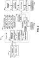
- FIG. 2 is a block diagram of a system 200 to integrate information in a coordinated mission for a fleet of user vehicles, according to one embodiment.
- the user vehicles can include various aerial vehicles, such as manned or unmanned aircraft, helicopters, UAM vehicles, or the like.
- the various components of system 200 can be located onboard the user vehicles, in a ground station, or both.
- the system 200 includes a communication unit 210 that hosts a communication (COM) radio 212, and a user (pilot) audio module 214. At least one processor 202 is in operative communication with communication unit 210. The processor 202 hosts a plurality of processing modules described further hereafter.
- the COM radio 212 and audio module 214 are configured to send audio signals.
- Examples of various audio signals that can be transmitted include ATC clearance audio, automatic terminal information service (ATIS) messages, aerodrome flight information service (AFIS) messages, terminal weather information for pilots (TWIP) messages, airport operation center (AOC) messages, pilot voice commands, and the like.
- ATC automatic terminal information service
- AFIS aerodrome flight information service
- TWIP terminal weather information for pilots
- AOC airport operation center
- a first processing module hosted by processor 202 comprises a speech-to-text converter module 220, such as an air traffic control (ATC) transcription module, which is configured to receive the audio signals from COM radio 212 and audio module 214.
- the speech-to-text converter module 220 is operative to convert the received audio signals to corresponding text messages.
- a second processing module comprises a keyword spotter and sentence segmentor module 230, which is configured to receive the corresponding text messages from speech-to-text converter module 220.
- the keyword spotter and sentence segmentor module 230 is operative to analyze the received text messages for selected words and to segment the text to provide parts of speech (POS) that include a call sign and/or voice data.
- POS parts of speech
- a third processing module comprises a call sign extractor module 234, which is configured to receive the segmented text from keyword spotter and sentence segmentor module 230.
- the call sign extractor module 234 is operative to identify the call sign from the segmented text and produce corresponding call sign data.
- a fourth processing module comprises a speaker identification module 240, which is configured to receive the call sign data and/or voice data from call sign extractor module 234.
- the speaker identification module 240 operative to identify a speaker vehicle among the user vehicles by comparing the call sign data with stored call signs from a call sign database (DB) 244.
- DB call sign database
- the onboard user vehicle systems 250 are in operative communication with speaker identification module 240.
- the onboard user vehicle systems 250 are configured to send vehicle state data, such as aircraft state data, to speaker identification module 240.
- the onboard user vehicle systems 250 can include a flight management system (FMS) 252, a traffic collision avoidance system (TCAS) 253, a fuel monitoring system 254, electrical systems 255, a flight computer (FC) 256, a weather (WX) monitoring system 257, engine systems 258, a transponder (XPDR) 259, or the like.
- FMS flight management system
- TCAS traffic collision avoidance system
- FC flight computer
- WX weather monitoring system
- XPDR transponder
- a common display 268 onboard each of the user vehicles is in operative communication with speaker identification module 240.
- the common display 268 is configured to receive identifying information for the speaker vehicle from speaker identification module 240.
- a terrain/geographical reference database 264 can be in operative communication with speaker identification module 240 and common display 268.
- a symbol rendering unit 272 such as a symbol rendering graphics generation function (GGF) is in operative communication with common display 268, and with a graphical symbol database 276.
- the symbol rendering unit 272 is operative to provide rendering data for generating one or more graphical symbols on common display 268.
- the graphical symbol database 276 provides data for the graphical symbols to be rendered.
- a search light controller 280 is configured to send control signals to a search light feature extractor 284.
- the common display 268 is configured to receive search light data from search light feature extractor 282, which uses a search light and camera feed to identify a point of interest.
- each of the aircraft are dialed to a common radio frequency (RF).
- the call signs for each aircraft are already stored in selected databases, such as call sign database 244.
- the processing modules transcribe the audio message to text, perform pre- and post-processing of the audio signals, and identify parts of speech (POS), such as by using speech-to-text converter module 220, keyword spotter and sentence segmentor module 230, and call sign extractor module 234.
- POS parts of speech
- the method can identify a speaker aircraft by comparing the call sign from the POS with the stored call signs, to find the corresponding call sign of the speaker aircraft. This comparison step can be done by speaker identification module 240.
- COM radio 212 and/or audio module 214 can transmit audio signals to speech-to-text converter module 220, which sends corresponding text messages to keyword spotter and sentence segmentor module 230.
- the keyword spotter and sentence segmentor module 230 analyzes the received text for selected words and segment the text in order to provide POS including a call sign.
- the call sign extractor module 234 receives the segmented text from keyword spotter and sentence segmentor module 230.
- the call sign extractor module 234 identifies the call sign from the segmented text and transmits corresponding tokenized text/data to speaker identification module 240.
- the speaker identification module 240 receives information from call sign database 244.
- the speaker identification module 240 identifies a speaker aircraft by comparing the call sign with stored call signs from call sign database 244.
- the speaker identification module 240 then sends identifying information to terrain/geographical reference database 264, and also to common display 268.
- the method can obtain any available ADS-B out data for the speaker aircraft. The method then highlights the speaker aircraft in the common display of each aircraft. In addition, the method can mark a coverage area based on the ADS-B out data for all the aircraft in the mission, and can suggest a mission plan change based on an area coverage potential POI region.
- Data regarding the identified speaker aircraft can be supplied to various avionics in the aircraft in the mission through appropriate bus interfaces.
- Useful data such as speed, altitude, heading, etc., obtained from clearance information, can be made available to the various avionics in the aircraft through a common digital database.
- the method if the POS contains a reference feature, such as tent, wing, person, etc., then the method generates a corresponding graphical symbol and tags the graphical symbol in the location of a POI. If the POI is tagged, the method identifies a nearby ground feature, which is visible even at a poor visibility higher altitude, and tags that nearby ground feature to locate the POI. If the POI is tagged, the method captures the speaker aircraft location, altitude, viewing angle, and tag, along with the POI. If the speaker aircraft wants to share its point of view, the method enables an option to share the captured video with the other aircraft via the common displays.
- a reference feature such as tent, wing, person, etc.
- a POI position can be tagged graphically on the common display by either the pilot speaking audio, or by selecting from symbols available on the common display.
- a speech engine can be used to filter a call sign from a speaker aircraft. Then, the call sign can be confirmed in flight during a mission (e.g., during SAR, formation flying, etc.). For example, once the call sign is identified, ADS-B out data can be obtained from the a speaker aircraft to determine its position during flight. If an aircraft during formation flying has an emergency situation, a list of emergency parameters for the aircraft can be shown in the common displays of the other aircraft in the formation so that they can adjust the mission as needed, and provide aid for the aircraft in the emergency situation.
- a mission e.g., during SAR, formation flying, etc.
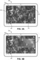
- Figure 3A is an example screenshot of a common display 300 for a user aircraft on a mission with other aircraft.
- a graphically highlighted speaker aircraft 310 is shown symbolically, and a graphical symbol 320 (tent) is rendered from a symbol table, according to the present approach.
- Other aircraft 312, 314, 316 in the mission are also shown symbolically on common display 300.
- Figure 3B is an example screenshot of common display 300, which shows the highlighted speaker aircraft 310, along with a rendering of an image feed 330 of a search area as seen from speaker aircraft 310.
- the image feed 330 is shared with the other aircraft in the mission on their respective common displays, according to the present approach.
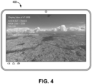
- Figure 4 is an example screenshot of a common display 400 for a user aircraft in a group of aircraft on a mission, which shows a list of emergency parameters for one of the aircraft that is in an emergency situation.
- the emergency parameters listed include:
- a computer or processor used in the present systems and methods can be implemented using software, firmware, hardware, or any appropriate combination thereof, as known to one of skill in the art. These may be supplemented by, or incorporated in, specially-designed application-specific integrated circuits (ASICs) or field programmable gate arrays (FPGAs).
- ASICs application-specific integrated circuits
- FPGAs field programmable gate arrays
- the computer or processor can also include functions with software programs, firmware, or other computer readable instructions for carrying out various process tasks, calculations, and control functions used in the present systems and methods.
- the present methods can be implemented by computer executable instructions, such as program modules or components, which are executed by at least one processor.
- program modules include routines, programs, objects, data components, data structures, algorithms, and the like, which perform particular tasks or implement particular abstract data types.
- Instructions for carrying out the various process tasks, calculations, and generation of other data used in the operation of the methods described herein can be implemented in software, firmware, or other computer- or processor-readable instructions. These instructions are typically stored on any appropriate computer program product that includes a computer readable medium used for storage of computer readable instructions or data structures. Such a computer readable medium can be any available media that can be accessed by a general purpose or special purpose computer or processor, or any programmable logic device.
- Suitable processor-readable media may include storage or memory media such as magnetic or optical media.
- storage or memory media may include conventional hard disks, compact discs, DVDs, Blu-ray discs, or other optical storage media; volatile or non-volatile media such as Random Access Memory (RAM); Read Only Memory (ROM), Electrically Erasable Programmable ROM (EEPROM), flash memory, and the like; or any other media that can be used to carry or store desired program code in the form of computer executable instructions or data structures.
- RAM Random Access Memory
- ROM Read Only Memory
- EEPROM Electrically Erasable Programmable ROM
- flash memory and the like
- any other media that can be used to carry or store desired program code in the form of computer executable instructions or data structures.
- Example 1 includes a method comprising: storing a call sign in a database for each user vehicle, among a group of user vehicles, in a coordinated mission; identifying a speaker vehicle among the user vehicles by comparing a call sign from parts of speech (POS) with the stored call signs; highlighting the identified speaker vehicle in a common display of each user vehicle; determining whether the POS from the speaker vehicle contains a reference to a point of interest (POI); generating a graphical symbol for the POI when the POS from the speaker vehicle contains a reference to the POI; and tagging the graphical symbol at a location of the POI in the common display of each user vehicle.
- POS parts of speech
- POI point of interest
- Example 2 includes the method of Example 1, wherein when the graphical symbol is tagged at the location of the POI, identifying at least one nearby ground feature that is visible at a higher altitude, and tagging the nearby ground feature in the common display of each user vehicle to aid in locating the POI.
- Example 3 includes the method of any of Examples 1-2, further comprising: sharing a video feed of the speaker vehicle with other user vehicles in the group via the common display in each user vehicle.
- Example 4 includes the method of any of Examples 1-3, wherein the user vehicles comprise a fleet of aerial vehicles.
- Example 5 includes the method of Example 4, wherein the aerial vehicles comprise manned aircraft, unmanned aircraft, helicopters, or urban air mobility vehicles.
- Example 6 includes a system to integrate information in a coordinated mission of a plurality of user vehicles, the system comprising: a communication unit that hosts a communication radio, and a user audio module; at least one processor in operative communication with the communication unit, the at least one processor hosting a plurality of processing modules comprising: a speech-to-text converter module configured to receive audio signals from the communication radio and the user audio module, and convert the audio signals to corresponding text messages; a keyword spotter and sentence segmentor module configured to receive the corresponding text messages from the speech-to-text converter module, the keyword spotter and sentence segmentor module operative to analyze the received text messages for selected words and to segment the text to provide parts of speech (POS) that include a call sign and/or voice data; a call sign extractor module configured to receive the segmented text from the keyword spotter and sentence segmentor module, the call sign extractor module operative to identify the call sign from the segmented text and produce corresponding call sign data; and a speaker identification module configured to receive the call sign data and/or voice data
- Example 7 includes the system of Example 6, further comprising a terrain/geographical reference database in operative communication with the speaker identification module and the common display.
- Example 8 includes the system of any of Examples 6-7, further comprising a search light controller configured to send control signals to a search light feature extractor.
- Example 9 includes the system of Example 8, wherein the common display is configured to receive search light data from the search light feature extractor.
- Example 10 includes the system of any of Examples 6-9, wherein the user vehicles comprise a fleet of aerial vehicles.
- Example 11 includes the system of Example 10, wherein the aerial vehicles comprise manned aircraft, unmanned aircraft, helicopters, or urban air mobility vehicles.
- Example 12 includes the system of any of Examples 6-11, wherein the speech-to-text converter module comprises an air traffic control (ATC) transcription module.
- ATC air traffic control
- Example 13 includes the system of any of Examples 6-12, wherein the audio signals comprise one or more of ATC clearance audio, pilot voice commands, automatic terminal information service (ATIS) messages, airport operation center (AOC) messages, aerodrome flight information service (AFIS) messages, or terminal weather information for pilots (TWIP) messages.
- ATC automatic terminal information service
- AOC airport operation center
- AFIS aerodrome flight information service
- TWIP terminal weather information for pilots
- Example 14 includes the system of any of Examples 6-13, wherein the onboard user vehicle systems comprise one or more of a flight management system, a traffic collision avoidance system (TCAS), a fuel monitoring system, electrical systems, a flight computer, a weather monitoring system, engine systems, or a transponder.
- TCAS traffic collision avoidance system
- Example 15 includes the system of any of Examples 6-14, wherein the speaker vehicle is graphically highlighted in the common display of each user vehicle.
- Example 16 includes the system of any of Examples 6-15, wherein when a user vehicle among the user vehicles is in an emergency situation, the common display in each user vehicle is configured to show a list of emergency parameters for the user vehicle in the emergency situation.
Landscapes
- Engineering & Computer Science (AREA)
- Physics & Mathematics (AREA)
- General Physics & Mathematics (AREA)
- Aviation & Aerospace Engineering (AREA)
- Multimedia (AREA)
- Theoretical Computer Science (AREA)
- Remote Sensing (AREA)
- Computational Linguistics (AREA)
- Health & Medical Sciences (AREA)
- Audiology, Speech & Language Pathology (AREA)
- Human Computer Interaction (AREA)
- Acoustics & Sound (AREA)
- Traffic Control Systems (AREA)
Abstract
A method and system to integrate information in a coordinated mission of a group of user vehicles is provided. The method comprises storing a call sign in a database for each user vehicle, among the group of user vehicles, in the coordinated mission; and identifying a speaker vehicle among the user vehicles by comparing a call sign from parts of speech (POS) with the stored call signs. The method further comprises highlighting the identified speaker vehicle in a common display of each user vehicle; and determining whether the POS from the speaker vehicle contains a reference to a point of interest (POI). The method generates a graphical symbol for the POI when the POS from the speaker vehicle contains a reference to the POI, and tags the graphical symbol at a location of the POI in the common display of each user vehicle.
Description
- Search and rescue (SAR) operations play an important role in reducing devastating impacts caused by disasters. Aerial vehicles are often deployed during missions to analyze a region and obtain the necessary information before proceeding to ground.
- In coordinated missions such as SAR, or formation flying, information sharing is challenging due to various reasons. For example, communications are done through radio telephony (RT), which is a broadcast type of communication where only one speaker can talk at a given time while others listen. When there are a number of vehicles in mission, it is difficult for all vehicle operators to explain their view/details when needed. Further, when the vehicle operators want to share information, this consumes more RT time, which in turn creates RT congestion. There are also additional problems specific to formation flying. For example, when an aircraft in the formation has an issue, the other aircraft in mission should be notified immediately as these aircraft are typically flying with minimum separation. Currently, a pilot having the aircraft issue must inform the other aircraft through RT, which might not be available.
- A method and system to integrate information in a coordinated mission of a group of user vehicles is described herein. The method comprises storing a call sign in a database for each user vehicle, among the group of user vehicles, in the coordinated mission; and identifying a speaker vehicle among the user vehicles by comparing a call sign from parts of speech (POS) with the stored call signs. The method further comprises highlighting the identified speaker vehicle in a common display of each user vehicle; and determining whether the POS from the speaker vehicle contains a reference to a point of interest (POI). The method generates a graphical symbol for the POI when the POS from the speaker vehicle contains a reference to the POI, and tags the graphical symbol at a location of the POI in the common display of each user vehicle.
- Features of the present invention will become apparent to those skilled in the art from the following description with reference to the drawings. Understanding that the drawings depict only typical embodiments and are not therefore to be considered limiting in scope, the invention will be described with additional specificity and detail through the use of the accompanying drawings, in which:
-
Figure 1 is a flow diagram for a method to integrate information for a coordinated mission of user vehicles, according to one implementation; -
Figure 2 is a block diagram of a system to integrate information in a coordinated mission for a fleet of aerial vehicles, according to one embodiment; -
Figures 3A and 3B are example screenshots of a common display for a user aircraft on a mission with other aircraft; and -
Figure 4 is an example screenshot of a common display for a user aircraft on a mission with other aircraft, showing a list of emergency parameters for one of the aircraft that is in an emergency situation. - In the following detailed description, embodiments are described in sufficient detail to enable those skilled in the art to practice the invention. It is to be understood that other embodiments may be utilized without departing from the scope of the invention. The following detailed description is, therefore, not to be taken in a limiting sense.
- A method and system to integrate vehicle systems for effective coordinated missions are described herein.
- In general, the present method and system are operative to identify a speaker vehicle among user vehicles in a mission, obtain a location of the speaker vehicle, and highlight features on a common display in each user vehicle. The method and system can also enable the speaker vehicle to share its camera feed or captured point of interest (POI) with the other user vehicles through the common display in each user vehicle. The user vehicles in the mission can include various combinations of manned or unmanned vehicles, such as airplanes, helicopters, urban air mobility (UAM) vehicles, and the like.
- The present method and system increase a coordinated mission's effectiveness by automatic identification of a particular user vehicle, such as a speaker aircraft, based on a call sign annunciation and mapping the call sign with the transponder data for the particular user vehicle, such as automatic dependent surveillance-broadcast (ADS-B) data for the speaker aircraft. For example, once the transponder data is derived through call sign filtering, the transponder data is mapped, along with data extracted from clearances, into various avionics systems. After successfully identifying the particular user vehicle, the present method and system directs the common display of each user vehicle in the mission to show various unique features.
- The common display implementation used in the present method and system can provide various features, including: mapping the call sign annunciations from the radio transmissions with a speaker aircraft's transponder data; speaker identification based on call sign; tagging/highlighting the speaker aircraft in the common displays; changing the common display view to the speaker's data/POI; populating a graphical symbol based on speaker transcription and tag the graphical symbol to the POI; and identifying and storing a geographical feature near to the POI that is visible at higher altitude and poor visibility.
- In another aspect, when a speaker aircraft is asking for emergency help (e.g., mayday) the present method maps a call sign of the speaker aircraft with its aircraft transponder data (such as ADS-B data), and then performs the following steps: identify the location of the speaker aircraft, and change the common displays in all aircraft in mission to show an icon of the speaker aircraft. In addition, during an emergency situation, the common displays can show the camera feed along with other vital information, such as speed, altitude, type of failure, and the like, of the distressed aircraft. The method quickly recognizes and responds, just based on the call sign, to the aircraft that is asking for emergency help. The method then supplies the traffic aircraft identification to various avionics of other aircraft.
- The present approach can reduce the workload of vehicle operators such as pilots by significantly reducing the time to explain the POI situation and sharing their ownship identity. This enables highly effective and time efficient group communications, such for various airplanes flying together on a mission.
- The present approach for aircraft identification, based on call signs and locating the aircraft based on an ADS-B profile, has various use cases. For example, current traffic displays (e.g., traffic collision avoidance system (TCAS)) operate based on transponder data, and voice data is not taken into account. The present method can highlight an aircraft that is talking in such traffic displays. In addition, the present method can be used to highlight a distressed aircraft and share its cockpit profile to other aircraft flying in the same region.
- In addition, when a flight management system (FMS) of aircraft is already provided with search and rescue (SAR) patterns, tagging/highlighting the speaker aircraft along with the POI will strengthen the SAR patterns usage. The present method can also be used to strengthen a surface indications and alert (SURF-IA) system. Currently, SURF-IA works only based on ADS-B data. Incorporating voice data after call sign filtering can strengthen the SURF-IA operation. The present method also addresses the single pilot operational issue by sending critical data to other user aircraft through the common displays.
- Further, the graphical symbol association to the POI of the present method can help pilots in a mission to increase their overall awareness of a search area, and ensures that everyone knows the overall findings in the search area. Moreover, the call sign-based aircraft identification and data sharing via the common displays can help in improving the enhancement of various avionics devices.
- Further details regarding the present method and system are described as follows with reference to the drawings.
-
Figure 1 is a flow diagram for amethod 100 to integrate information for an effective coordinated mission, according to one implementation. Themethod 100 comprises storing a call sign in a database for each user vehicle, among a group of user vehicles, for use in a coordinated mission (block 110). Themethod 100 further comprises identifying a speaker vehicle among the user vehicles by comparing a call sign from parts of speech (POS) with the stored call signs (block 112); and highlighting the identified speaker vehicle in a common display of each user vehicle (block 114). Themethod 100 then determines whether the POS from the speaker vehicle contains a reference to a point of interest (POI) (block 116); and generates a graphical symbol for the POI when the POS from the speaker vehicle contains a reference to the POI (block 118). Themethod 100 then provides for tagging the graphical symbol at a location of the POI in the common display of each user vehicle (block 120). - In some implementations, when the graphical symbol is tagged at the location of the POI,
method 100 can identify at least one nearby ground feature that is visible at a higher altitude, and can tag the nearby ground feature in the common display of each user vehicle to aid in locating the POI. In addition,method 100 can also provide for sharing a video feed of the speaker vehicle with the other user vehicles via the common display in each user vehicle. In further implementations,method 100 can further provide for marking a coverage area of the mission in the common display for each user vehicle, and adjusting one or more parameters of the mission based on the coverage area and one or more potential POI regions. -
Figure 2 is a block diagram of asystem 200 to integrate information in a coordinated mission for a fleet of user vehicles, according to one embodiment. The user vehicles can include various aerial vehicles, such as manned or unmanned aircraft, helicopters, UAM vehicles, or the like. The various components ofsystem 200 can be located onboard the user vehicles, in a ground station, or both. - The
system 200 includes acommunication unit 210 that hosts a communication (COM)radio 212, and a user (pilot)audio module 214. At least oneprocessor 202 is in operative communication withcommunication unit 210. Theprocessor 202 hosts a plurality of processing modules described further hereafter. - The
COM radio 212 andaudio module 214 are configured to send audio signals. Examples of various audio signals that can be transmitted include ATC clearance audio, automatic terminal information service (ATIS) messages, aerodrome flight information service (AFIS) messages, terminal weather information for pilots (TWIP) messages, airport operation center (AOC) messages, pilot voice commands, and the like. - A first processing module hosted by
processor 202 comprises a speech-to-text converter module 220, such as an air traffic control (ATC) transcription module, which is configured to receive the audio signals fromCOM radio 212 andaudio module 214. The speech-to-text converter module 220 is operative to convert the received audio signals to corresponding text messages. - A second processing module comprises a keyword spotter and
sentence segmentor module 230, which is configured to receive the corresponding text messages from speech-to-text converter module 220. The keyword spotter andsentence segmentor module 230 is operative to analyze the received text messages for selected words and to segment the text to provide parts of speech (POS) that include a call sign and/or voice data. - A third processing module comprises a call
sign extractor module 234, which is configured to receive the segmented text from keyword spotter andsentence segmentor module 230. The callsign extractor module 234 is operative to identify the call sign from the segmented text and produce corresponding call sign data. - A fourth processing module comprises a
speaker identification module 240, which is configured to receive the call sign data and/or voice data from callsign extractor module 234. Thespeaker identification module 240 operative to identify a speaker vehicle among the user vehicles by comparing the call sign data with stored call signs from a call sign database (DB) 244. - Various onboard
user vehicle systems 250 are in operative communication withspeaker identification module 240. The onboarduser vehicle systems 250 are configured to send vehicle state data, such as aircraft state data, tospeaker identification module 240. The onboarduser vehicle systems 250 can include a flight management system (FMS) 252, a traffic collision avoidance system (TCAS) 253, afuel monitoring system 254,electrical systems 255, a flight computer (FC) 256, a weather (WX)monitoring system 257, engine systems 258, a transponder (XPDR) 259, or the like. - A
common display 268 onboard each of the user vehicles is in operative communication withspeaker identification module 240. Thecommon display 268 is configured to receive identifying information for the speaker vehicle fromspeaker identification module 240. In addition, a terrain/geographical reference database 264 can be in operative communication withspeaker identification module 240 andcommon display 268. - A
symbol rendering unit 272, such as a symbol rendering graphics generation function (GGF), is in operative communication withcommon display 268, and with agraphical symbol database 276. Thesymbol rendering unit 272 is operative to provide rendering data for generating one or more graphical symbols oncommon display 268. Thegraphical symbol database 276 provides data for the graphical symbols to be rendered. - Optionally, a
search light controller 280 is configured to send control signals to a searchlight feature extractor 284. Thecommon display 268 is configured to receive search light data from search light feature extractor 282, which uses a search light and camera feed to identify a point of interest. - In an operational method for a coordinated mission of an aircraft group, which can employ
system 200, each of the aircraft are dialed to a common radio frequency (RF). The call signs for each aircraft are already stored in selected databases, such ascall sign database 244. When an audio message is provided, such as bycommunication unit 210, the processing modules transcribe the audio message to text, perform pre- and post-processing of the audio signals, and identify parts of speech (POS), such as by using speech-to-text converter module 220, keyword spotter andsentence segmentor module 230, and callsign extractor module 234. The method can identify a speaker aircraft by comparing the call sign from the POS with the stored call signs, to find the corresponding call sign of the speaker aircraft. This comparison step can be done byspeaker identification module 240. - For example,
COM radio 212 and/oraudio module 214 can transmit audio signals to speech-to-text converter module 220, which sends corresponding text messages to keyword spotter andsentence segmentor module 230. The keyword spotter andsentence segmentor module 230 analyzes the received text for selected words and segment the text in order to provide POS including a call sign. The callsign extractor module 234 receives the segmented text from keyword spotter andsentence segmentor module 230. The callsign extractor module 234 identifies the call sign from the segmented text and transmits corresponding tokenized text/data tospeaker identification module 240. Thespeaker identification module 240 receives information fromcall sign database 244. Thespeaker identification module 240 identifies a speaker aircraft by comparing the call sign with stored call signs fromcall sign database 244. Thespeaker identification module 240 then sends identifying information to terrain/geographical reference database 264, and also tocommon display 268. - Once the speaker aircraft is identified, the method can obtain any available ADS-B out data for the speaker aircraft. The method then highlights the speaker aircraft in the common display of each aircraft. In addition, the method can mark a coverage area based on the ADS-B out data for all the aircraft in the mission, and can suggest a mission plan change based on an area coverage potential POI region.
- Data regarding the identified speaker aircraft can be supplied to various avionics in the aircraft in the mission through appropriate bus interfaces. Useful data, such as speed, altitude, heading, etc., obtained from clearance information, can be made available to the various avionics in the aircraft through a common digital database.
- In one example, if the POS contains a reference feature, such as tent, wing, person, etc., then the method generates a corresponding graphical symbol and tags the graphical symbol in the location of a POI. If the POI is tagged, the method identifies a nearby ground feature, which is visible even at a poor visibility higher altitude, and tags that nearby ground feature to locate the POI. If the POI is tagged, the method captures the speaker aircraft location, altitude, viewing angle, and tag, along with the POI. If the speaker aircraft wants to share its point of view, the method enables an option to share the captured video with the other aircraft via the common displays.
- In addition, a POI position can be tagged graphically on the common display by either the pilot speaking audio, or by selecting from symbols available on the common display.
- In other implementations, a speech engine can be used to filter a call sign from a speaker aircraft. Then, the call sign can be confirmed in flight during a mission (e.g., during SAR, formation flying, etc.). For example, once the call sign is identified, ADS-B out data can be obtained from the a speaker aircraft to determine its position during flight. If an aircraft during formation flying has an emergency situation, a list of emergency parameters for the aircraft can be shown in the common displays of the other aircraft in the formation so that they can adjust the mission as needed, and provide aid for the aircraft in the emergency situation.
-
Figure 3A is an example screenshot of acommon display 300 for a user aircraft on a mission with other aircraft. As depicted, a graphically highlightedspeaker aircraft 310 is shown symbolically, and a graphical symbol 320 (tent) is rendered from a symbol table, according to the present approach.Other aircraft common display 300.Figure 3B is an example screenshot ofcommon display 300, which shows the highlightedspeaker aircraft 310, along with a rendering of animage feed 330 of a search area as seen fromspeaker aircraft 310. The image feed 330 is shared with the other aircraft in the mission on their respective common displays, according to the present approach. -
Figure 4 is an example screenshot of acommon display 400 for a user aircraft in a group of aircraft on a mission, which shows a list of emergency parameters for one of the aircraft that is in an emergency situation. In this example, the emergency parameters listed include: - Display View of VT-SRB (identifies view from aircraft in emergency situation by its call sign);
- ADS-B OUT - FAILED (failure of ADS-B out feature of aircraft in emergency situation);
- XPDR Code - 2234 (transponder code from aircraft in emergency situation);
- TAS - 320 (true airspeed of aircraft in emergency situation);
- ALT - 5000 Feet (altitude of aircraft in emergency situation);
- No Pilot Input for 15 seconds (time of no input by pilot of aircraft in emergency situation);
- PTT is not pressed for 30 seconds (time push-to-talk (PPT) feature not used by pilot of aircraft in emergency situation).
- A computer or processor used in the present systems and methods can be implemented using software, firmware, hardware, or any appropriate combination thereof, as known to one of skill in the art. These may be supplemented by, or incorporated in, specially-designed application-specific integrated circuits (ASICs) or field programmable gate arrays (FPGAs). The computer or processor can also include functions with software programs, firmware, or other computer readable instructions for carrying out various process tasks, calculations, and control functions used in the present systems and methods.
- The present methods can be implemented by computer executable instructions, such as program modules or components, which are executed by at least one processor. Generally, program modules include routines, programs, objects, data components, data structures, algorithms, and the like, which perform particular tasks or implement particular abstract data types.
- Instructions for carrying out the various process tasks, calculations, and generation of other data used in the operation of the methods described herein can be implemented in software, firmware, or other computer- or processor-readable instructions. These instructions are typically stored on any appropriate computer program product that includes a computer readable medium used for storage of computer readable instructions or data structures. Such a computer readable medium can be any available media that can be accessed by a general purpose or special purpose computer or processor, or any programmable logic device.
- Suitable processor-readable media may include storage or memory media such as magnetic or optical media. For example, storage or memory media may include conventional hard disks, compact discs, DVDs, Blu-ray discs, or other optical storage media; volatile or non-volatile media such as Random Access Memory (RAM); Read Only Memory (ROM), Electrically Erasable Programmable ROM (EEPROM), flash memory, and the like; or any other media that can be used to carry or store desired program code in the form of computer executable instructions or data structures.
- Example 1 includes a method comprising: storing a call sign in a database for each user vehicle, among a group of user vehicles, in a coordinated mission; identifying a speaker vehicle among the user vehicles by comparing a call sign from parts of speech (POS) with the stored call signs; highlighting the identified speaker vehicle in a common display of each user vehicle; determining whether the POS from the speaker vehicle contains a reference to a point of interest (POI); generating a graphical symbol for the POI when the POS from the speaker vehicle contains a reference to the POI; and tagging the graphical symbol at a location of the POI in the common display of each user vehicle.
- Example 2 includes the method of Example 1, wherein when the graphical symbol is tagged at the location of the POI, identifying at least one nearby ground feature that is visible at a higher altitude, and tagging the nearby ground feature in the common display of each user vehicle to aid in locating the POI.
- Example 3 includes the method of any of Examples 1-2, further comprising: sharing a video feed of the speaker vehicle with other user vehicles in the group via the common display in each user vehicle.
- Example 4 includes the method of any of Examples 1-3, wherein the user vehicles comprise a fleet of aerial vehicles.
- Example 5 includes the method of Example 4, wherein the aerial vehicles comprise manned aircraft, unmanned aircraft, helicopters, or urban air mobility vehicles.
- Example 6 includes a system to integrate information in a coordinated mission of a plurality of user vehicles, the system comprising: a communication unit that hosts a communication radio, and a user audio module; at least one processor in operative communication with the communication unit, the at least one processor hosting a plurality of processing modules comprising: a speech-to-text converter module configured to receive audio signals from the communication radio and the user audio module, and convert the audio signals to corresponding text messages; a keyword spotter and sentence segmentor module configured to receive the corresponding text messages from the speech-to-text converter module, the keyword spotter and sentence segmentor module operative to analyze the received text messages for selected words and to segment the text to provide parts of speech (POS) that include a call sign and/or voice data; a call sign extractor module configured to receive the segmented text from the keyword spotter and sentence segmentor module, the call sign extractor module operative to identify the call sign from the segmented text and produce corresponding call sign data; and a speaker identification module configured to receive the call sign data and/or voice data from the call sign extractor module, the speaker identification module operative to identify a speaker vehicle among the user vehicles by comparing the call sign data with stored call signs from a call sign database; one or more onboard user vehicle systems in operative communication with the speaker identification module, the one or more onboard user vehicle systems configured to send vehicle state data to the speaker identification module; a common display onboard each of the user vehicles and in operative communication with the speaker identification module, the common display configured to receive identifying information for the speaker vehicle from the speaker identification module; and a symbol rendering unit in operative communication with the common display and with a graphical symbol database, the symbol rendering unit operative to provide rendering data for generating one or more graphical symbols on the common display.
- Example 7 includes the system of Example 6, further comprising a terrain/geographical reference database in operative communication with the speaker identification module and the common display.
- Example 8 includes the system of any of Examples 6-7, further comprising a search light controller configured to send control signals to a search light feature extractor.
- Example 9 includes the system of Example 8, wherein the common display is configured to receive search light data from the search light feature extractor.
- Example 10 includes the system of any of Examples 6-9, wherein the user vehicles comprise a fleet of aerial vehicles.
- Example 11 includes the system of Example 10, wherein the aerial vehicles comprise manned aircraft, unmanned aircraft, helicopters, or urban air mobility vehicles.
- Example 12 includes the system of any of Examples 6-11, wherein the speech-to-text converter module comprises an air traffic control (ATC) transcription module.
- Example 13 includes the system of any of Examples 6-12, wherein the audio signals comprise one or more of ATC clearance audio, pilot voice commands, automatic terminal information service (ATIS) messages, airport operation center (AOC) messages, aerodrome flight information service (AFIS) messages, or terminal weather information for pilots (TWIP) messages.
- Example 14 includes the system of any of Examples 6-13, wherein the onboard user vehicle systems comprise one or more of a flight management system, a traffic collision avoidance system (TCAS), a fuel monitoring system, electrical systems, a flight computer, a weather monitoring system, engine systems, or a transponder.
- Example 15 includes the system of any of Examples 6-14, wherein the speaker vehicle is graphically highlighted in the common display of each user vehicle.
- Example 16 includes the system of any of Examples 6-15, wherein when a user vehicle among the user vehicles is in an emergency situation, the common display in each user vehicle is configured to show a list of emergency parameters for the user vehicle in the emergency situation.
- From the foregoing, it will be appreciated that, although specific embodiments have been described herein for purposes of illustration, various modifications may be made without deviating from the scope of the disclosure. Thus, the described embodiments are to be considered in all respects only as illustrative and not restrictive. In addition, all changes that come within the meaning and range of equivalency of the claims are to be embraced within their scope.
Claims (10)
- A method comprising:storing a call sign in a database for each user vehicle, among a group of user vehicles, in a coordinated mission;identifying a speaker vehicle among the user vehicles by comparing a call sign from parts of speech (POS) with the stored call signs;highlighting the identified speaker vehicle in a common display of each user vehicle;determining whether the POS from the speaker vehicle contains a reference to a point of interest (POI);generating a graphical symbol for the POI when the POS from the speaker vehicle contains a reference to the POI; andtagging the graphical symbol at a location of the POI in the common display of each user vehicle.
- The method of claim 1, wherein when the graphical symbol is tagged at the location of the POI, identifying at least one nearby ground feature that is visible at a higher altitude, and tagging the nearby ground feature in the common display of each user vehicle to aid in locating the POI.
- The method of claim 1, further comprising:
sharing a video feed of the speaker vehicle with other user vehicles in the group via the common display in each user vehicle. - The method of claim 1, wherein the user vehicles comprise a fleet of aerial vehicles.
- A system to integrate information in a coordinated mission of a plurality of user vehicles, the system comprising:a communication unit that hosts a communication radio, and a user audio module;at least one processor in operative communication with the communication unit, the at least one processor hosting a plurality of processing modules comprising:a speech-to-text converter module configured to receive audio signals from the communication radio and the user audio module, and convert the audio signals to corresponding text messages;a keyword spotter and sentence segmentor module configured to receive the corresponding text messages from the speech-to-text converter module, the keyword spotter and sentence segmentor module operative to analyze the received text messages for selected words and to segment the text to provide parts of speech (POS) that include a call sign and/or voice data;a call sign extractor module configured to receive the segmented text from the keyword spotter and sentence segmentor module, the call sign extractor module operative to identify the call sign from the segmented text and produce corresponding call sign data; anda speaker identification module configured to receive the call sign data and/or voice data from the call sign extractor module, the speaker identification module operative to identify a speaker vehicle among the user vehicles by comparing the call sign data with stored call signs from a call sign database;one or more onboard user vehicle systems in operative communication with the speaker identification module, the one or more onboard user vehicle systems configured to send vehicle state data to the speaker identification module;a common display onboard each of the user vehicles and in operative communication with the speaker identification module, the common display configured to receive identifying information for the speaker vehicle from the speaker identification module; anda symbol rendering unit in operative communication with the common display and with a graphical symbol database, the symbol rendering unit operative to provide rendering data for generating one or more graphical symbols on the common display.
- The system of claim 5, further comprising a terrain/geographical reference database in operative communication with the speaker identification module and the common display.
- The system of claim 5, further comprising a search light controller configured to send control signals to a search light feature extractor, wherein the common display is configured to receive search light data from the search light feature extractor.
- The system of claim 5, wherein the audio signals comprise one or more of ATC clearance audio, pilot voice commands, automatic terminal information service (ATIS) messages, airport operation center (AOC) messages, aerodrome flight information service (AFIS) messages, or terminal weather information for pilots (TWIP) messages.
- The system of claim 5, wherein the onboard user vehicle systems comprise one or more of a flight management system, a traffic collision avoidance system (TCAS), a fuel monitoring system, electrical systems, a flight computer, a weather monitoring system, engine systems, or a transponder.
- The system of claim 5, wherein when a user vehicle among the user vehicles is in an emergency situation, the common display in each user vehicle is configured to show a list of emergency parameters for the user vehicle in the emergency situation.
Applications Claiming Priority (1)
| Application Number | Priority Date | Filing Date | Title |
|---|---|---|---|
| US18/467,480 US12626603B2 (en) | 2023-09-14 | 2023-09-14 | System and method to integrate vehicle information for effective coordinated missions |
Publications (1)
| Publication Number | Publication Date |
|---|---|
| EP4524934A1 true EP4524934A1 (en) | 2025-03-19 |
Family
ID=92538884
Family Applications (1)
| Application Number | Title | Priority Date | Filing Date |
|---|---|---|---|
| EP24195895.8A Pending EP4524934A1 (en) | 2023-09-14 | 2024-08-22 | System and method to integrate vehicle information for effective coordinated missions |
Country Status (2)
| Country | Link |
|---|---|
| US (1) | US12626603B2 (en) |
| EP (1) | EP4524934A1 (en) |
Families Citing this family (1)
| Publication number | Priority date | Publication date | Assignee | Title |
|---|---|---|---|---|
| US20250239256A1 (en) * | 2024-01-21 | 2025-07-24 | Armin Ellis | Computer-implemented methods and systems for displaying textual information in a native mobile application |
Citations (4)
| Publication number | Priority date | Publication date | Assignee | Title |
|---|---|---|---|---|
| EP3321916A2 (en) * | 2016-11-09 | 2018-05-16 | Honeywell International Inc. | Systems and methods for contextual tagging of data on vehicle display |
| US20200172264A1 (en) * | 2018-12-04 | 2020-06-04 | Honeywell International Inc. | Searchlight auto-land system |
| EP3693947A1 (en) * | 2019-02-06 | 2020-08-12 | Honeywell International Inc. | System and method to identify, depict and alert distress and special traffic based on at least squawk codes |
| JP2021033944A (en) * | 2019-08-29 | 2021-03-01 | 株式会社Jvcケンウッド | Communication equipment, communication methods and programs |
Family Cites Families (21)
| Publication number | Priority date | Publication date | Assignee | Title |
|---|---|---|---|---|
| US7127683B2 (en) | 2001-08-21 | 2006-10-24 | The Boeing Company | Method to detect application spoofing in mixed use avionics display |
| NO326770B1 (en) * | 2006-05-26 | 2009-02-16 | Tandberg Telecom As | Video conference method and system with dynamic layout based on word detection |
| FR2915615B1 (en) | 2007-04-27 | 2009-06-05 | Airbus France Sas | DISPLAY SYSTEM FOR AN AIRCRAFT STEERING STATION. |
| FR2918349B1 (en) | 2007-07-05 | 2009-10-02 | Airbus France Sa | SYSTEM FOR DISPLAYING AVIONIC AND NON-AVIONIC APPLICATIONS |
| US20090138521A1 (en) | 2007-09-17 | 2009-05-28 | Honeywell International Inc. | Method and system for sharing information between disparate data sources in a network |
| US20110078564A1 (en) | 2009-08-24 | 2011-03-31 | Almodovar Herraiz Daniel | Converting Text Messages into Graphical Image Strings |
| FR2954564B1 (en) | 2009-12-23 | 2012-07-13 | Thales Sa | SYSTEM AND METHOD FOR AIDING THE IDENTIFICATION AND CONTROL OF AIRCRAFT PRESENT IN AN AIRCRAFT SECTOR TO BE MONITORED. |
| US8723670B2 (en) | 2011-03-08 | 2014-05-13 | Roy Rabey | Audio/visual annuciator for marking points of interest |
| CN102270451B (en) | 2011-08-18 | 2013-05-29 | 安徽科大讯飞信息科技股份有限公司 | Method and system for identifying speaker |
| US10078645B2 (en) * | 2013-02-19 | 2018-09-18 | Digitalglobe, Inc. | Crowdsourced feature identification and orthorectification |
| GB2513559B8 (en) * | 2013-04-22 | 2016-06-29 | Ge Aviat Systems Ltd | Unknown speaker identification system |
| US9105183B2 (en) | 2013-06-17 | 2015-08-11 | Honeywell International Inc. | System and method for graphically displaying aircraft traffic information using aircraft symbology |
| US9704405B2 (en) | 2014-06-12 | 2017-07-11 | Honeywell International Inc. | Aircraft display systems and methods for providing an aircraft display for use with airport departure and arrival procedures |
| US11023541B2 (en) | 2014-12-30 | 2021-06-01 | Rovi Guides, Inc. | Methods and systems for providing media recommendations based on user location |
| US9430949B1 (en) * | 2015-03-25 | 2016-08-30 | Honeywell International Inc. | Verbal taxi clearance system |
| US10417918B2 (en) * | 2016-01-20 | 2019-09-17 | Honeywell International Inc. | Methods and systems to assist in a search and rescue mission |
| US10157616B2 (en) | 2016-12-19 | 2018-12-18 | Honeywell International Inc. | Methods and apparatus for post-processing speech recognition results of received radio voice messages onboard an aircraft |
| US20190147858A1 (en) * | 2017-11-16 | 2019-05-16 | Honeywell International Inc. | Methods, systems and apparatuses for improving speech recognition using touch-based predictive modeling |
| FR3080941B1 (en) | 2018-05-04 | 2020-04-17 | Thales | VOICE RECOGNITION SYSTEM AND METHOD FOR AIRCRAFT |
| US11030908B2 (en) | 2018-05-17 | 2021-06-08 | Rockwell Collins, Inc. | System and method for identification and assessment of abnormal behavior of nearby aircraft |
| US20210019545A1 (en) | 2019-07-16 | 2021-01-21 | Honeywell International Inc. | Method and system to display object locations during a search and rescue operation |
-
2023
- 2023-09-14 US US18/467,480 patent/US12626603B2/en active Active
-
2024
- 2024-08-22 EP EP24195895.8A patent/EP4524934A1/en active Pending
Patent Citations (4)
| Publication number | Priority date | Publication date | Assignee | Title |
|---|---|---|---|---|
| EP3321916A2 (en) * | 2016-11-09 | 2018-05-16 | Honeywell International Inc. | Systems and methods for contextual tagging of data on vehicle display |
| US20200172264A1 (en) * | 2018-12-04 | 2020-06-04 | Honeywell International Inc. | Searchlight auto-land system |
| EP3693947A1 (en) * | 2019-02-06 | 2020-08-12 | Honeywell International Inc. | System and method to identify, depict and alert distress and special traffic based on at least squawk codes |
| JP2021033944A (en) * | 2019-08-29 | 2021-03-01 | 株式会社Jvcケンウッド | Communication equipment, communication methods and programs |
Also Published As
| Publication number | Publication date |
|---|---|
| US12626603B2 (en) | 2026-05-12 |
| US20250095499A1 (en) | 2025-03-20 |
Similar Documents
| Publication | Publication Date | Title |
|---|---|---|
| EP3474259B1 (en) | Method and system for contextually concatenating display, aural, and voice alerts | |
| CN108460995B (en) | Display system and method for runway intrusion prevention | |
| US10847145B2 (en) | Voice recognition system and method for aircraft | |
| US9620020B2 (en) | Communication-based monitoring of compliance with aviation regulations and operating procedures | |
| US10157617B2 (en) | System and method for rendering an aircraft cockpit display for use with ATC conditional clearance instructions | |
| US11973570B2 (en) | Methods and systems for assisting radio frequency selection | |
| EP3627477B1 (en) | Systems and methods for contextual alerts during ground operations | |
| US10127821B2 (en) | Aircraft systems and methods to improve airport traffic management | |
| US12260765B2 (en) | Systems and methods for alerting when an intruder trend vector is predicted to intercept with an aircraft taxi path | |
| US8681040B1 (en) | System and method for aiding pilots in resolving flight ID confusion | |
| US12626603B2 (en) | System and method to integrate vehicle information for effective coordinated missions | |
| US12488692B2 (en) | Systems and methods for identifying context for cockpit alerts | |
| US10902732B2 (en) | Method and system for monitoring execution of conditional air traffic control clearances for an aircraft | |
| US12469395B2 (en) | Method and system to filter and sort clearances in air traffic control (ATC) transcription | |
| EP4160572A1 (en) | Systems and methods for alerting when an intruder trend vector is predicted to intercept with an aircraft taxi path | |
| EP3573037A1 (en) | Systems and methods for predicting loss of separation events | |
| EP4145421B1 (en) | Systems and methods for transcribing and analyzing broadcast messages in an aircraft | |
| US20240265814A1 (en) | System and methods for improved situational awareness in aviation | |
| EP4287165A1 (en) | Method and system to filter and sort clearances in air traffic control (atc) transcription | |
| US20250239256A1 (en) | Computer-implemented methods and systems for displaying textual information in a native mobile application |
Legal Events
| Date | Code | Title | Description |
|---|---|---|---|
| PUAI | Public reference made under article 153(3) epc to a published international application that has entered the european phase |
Free format text: ORIGINAL CODE: 0009012 |
|
| STAA | Information on the status of an ep patent application or granted ep patent |
Free format text: STATUS: THE APPLICATION HAS BEEN PUBLISHED |
|
| AK | Designated contracting states |
Kind code of ref document: A1 Designated state(s): AL AT BE BG CH CY CZ DE DK EE ES FI FR GB GR HR HU IE IS IT LI LT LU LV MC ME MK MT NL NO PL PT RO RS SE SI SK SM TR |
|
| STAA | Information on the status of an ep patent application or granted ep patent |
Free format text: STATUS: REQUEST FOR EXAMINATION WAS MADE |
|
| 17P | Request for examination filed |
Effective date: 20250826 |