EP4506222A1 - Information processing method and information processing device - Google Patents
Information processing method and information processing device Download PDFInfo
- Publication number
- EP4506222A1 EP4506222A1 EP22936424.5A EP22936424A EP4506222A1 EP 4506222 A1 EP4506222 A1 EP 4506222A1 EP 22936424 A EP22936424 A EP 22936424A EP 4506222 A1 EP4506222 A1 EP 4506222A1
- Authority
- EP
- European Patent Office
- Prior art keywords
- cluster
- timing
- ranging
- curb
- point
- Prior art date
- Legal status (The legal status is an assumption and is not a legal conclusion. Google has not performed a legal analysis and makes no representation as to the accuracy of the status listed.)
- Withdrawn
Links
Images


Classifications
-
- G—PHYSICS
- G06—COMPUTING OR CALCULATING; COUNTING
- G06V—IMAGE OR VIDEO RECOGNITION OR UNDERSTANDING
- G06V20/00—Scenes; Scene-specific elements
- G06V20/50—Context or environment of the image
- G06V20/56—Context or environment of the image exterior to a vehicle by using sensors mounted on the vehicle
- G06V20/58—Recognition of moving objects or obstacles, e.g. vehicles or pedestrians; Recognition of traffic objects, e.g. traffic signs, traffic lights or roads
-
- G—PHYSICS
- G01—MEASURING; TESTING
- G01S—RADIO DIRECTION-FINDING; RADIO NAVIGATION; DETERMINING DISTANCE OR VELOCITY BY USE OF RADIO WAVES; LOCATING OR PRESENCE-DETECTING BY USE OF THE REFLECTION OR RERADIATION OF RADIO WAVES; ANALOGOUS ARRANGEMENTS USING OTHER WAVES
- G01S17/00—Systems using the reflection or reradiation of electromagnetic waves other than radio waves, e.g. lidar systems
- G01S17/88—Lidar systems specially adapted for specific applications
- G01S17/93—Lidar systems specially adapted for specific applications for anti-collision purposes
-
- G—PHYSICS
- G01—MEASURING; TESTING
- G01S—RADIO DIRECTION-FINDING; RADIO NAVIGATION; DETERMINING DISTANCE OR VELOCITY BY USE OF RADIO WAVES; LOCATING OR PRESENCE-DETECTING BY USE OF THE REFLECTION OR RERADIATION OF RADIO WAVES; ANALOGOUS ARRANGEMENTS USING OTHER WAVES
- G01S17/00—Systems using the reflection or reradiation of electromagnetic waves other than radio waves, e.g. lidar systems
- G01S17/02—Systems using the reflection of electromagnetic waves other than radio waves
- G01S17/06—Systems determining position data of a target
- G01S17/42—Simultaneous measurement of distance and other co-ordinates
-
- G—PHYSICS
- G01—MEASURING; TESTING
- G01S—RADIO DIRECTION-FINDING; RADIO NAVIGATION; DETERMINING DISTANCE OR VELOCITY BY USE OF RADIO WAVES; LOCATING OR PRESENCE-DETECTING BY USE OF THE REFLECTION OR RERADIATION OF RADIO WAVES; ANALOGOUS ARRANGEMENTS USING OTHER WAVES
- G01S17/00—Systems using the reflection or reradiation of electromagnetic waves other than radio waves, e.g. lidar systems
- G01S17/88—Lidar systems specially adapted for specific applications
- G01S17/93—Lidar systems specially adapted for specific applications for anti-collision purposes
- G01S17/931—Lidar systems specially adapted for specific applications for anti-collision purposes of land vehicles
-
- G—PHYSICS
- G01—MEASURING; TESTING
- G01S—RADIO DIRECTION-FINDING; RADIO NAVIGATION; DETERMINING DISTANCE OR VELOCITY BY USE OF RADIO WAVES; LOCATING OR PRESENCE-DETECTING BY USE OF THE REFLECTION OR RERADIATION OF RADIO WAVES; ANALOGOUS ARRANGEMENTS USING OTHER WAVES
- G01S7/00—Details of systems according to groups G01S13/00, G01S15/00, G01S17/00
- G01S7/02—Details of systems according to groups G01S13/00, G01S15/00, G01S17/00 of systems according to group G01S13/00
- G01S7/41—Details of systems according to groups G01S13/00, G01S15/00, G01S17/00 of systems according to group G01S13/00 using analysis of echo signal for target characterisation; Target signature; Target cross-section
-
- G—PHYSICS
- G01—MEASURING; TESTING
- G01S—RADIO DIRECTION-FINDING; RADIO NAVIGATION; DETERMINING DISTANCE OR VELOCITY BY USE OF RADIO WAVES; LOCATING OR PRESENCE-DETECTING BY USE OF THE REFLECTION OR RERADIATION OF RADIO WAVES; ANALOGOUS ARRANGEMENTS USING OTHER WAVES
- G01S7/00—Details of systems according to groups G01S13/00, G01S15/00, G01S17/00
- G01S7/48—Details of systems according to groups G01S13/00, G01S15/00, G01S17/00 of systems according to group G01S17/00
- G01S7/4802—Details of systems according to groups G01S13/00, G01S15/00, G01S17/00 of systems according to group G01S17/00 using analysis of echo signal for target characterisation; Target signature; Target cross-section
-
- G—PHYSICS
- G01—MEASURING; TESTING
- G01S—RADIO DIRECTION-FINDING; RADIO NAVIGATION; DETERMINING DISTANCE OR VELOCITY BY USE OF RADIO WAVES; LOCATING OR PRESENCE-DETECTING BY USE OF THE REFLECTION OR RERADIATION OF RADIO WAVES; ANALOGOUS ARRANGEMENTS USING OTHER WAVES
- G01S7/00—Details of systems according to groups G01S13/00, G01S15/00, G01S17/00
- G01S7/48—Details of systems according to groups G01S13/00, G01S15/00, G01S17/00 of systems according to group G01S17/00
- G01S7/4808—Evaluating distance, position or velocity data
-
- G—PHYSICS
- G06—COMPUTING OR CALCULATING; COUNTING
- G06F—ELECTRIC DIGITAL DATA PROCESSING
- G06F18/00—Pattern recognition
- G06F18/20—Analysing
- G06F18/23—Clustering techniques
-
- G—PHYSICS
- G06—COMPUTING OR CALCULATING; COUNTING
- G06V—IMAGE OR VIDEO RECOGNITION OR UNDERSTANDING
- G06V10/00—Arrangements for image or video recognition or understanding
- G06V10/70—Arrangements for image or video recognition or understanding using pattern recognition or machine learning
- G06V10/762—Arrangements for image or video recognition or understanding using pattern recognition or machine learning using clustering, e.g. of similar faces in social networks
-
- G—PHYSICS
- G06—COMPUTING OR CALCULATING; COUNTING
- G06V—IMAGE OR VIDEO RECOGNITION OR UNDERSTANDING
- G06V20/00—Scenes; Scene-specific elements
- G06V20/50—Context or environment of the image
- G06V20/56—Context or environment of the image exterior to a vehicle by using sensors mounted on the vehicle
- G06V20/588—Recognition of the road, e.g. of lane markings; Recognition of the vehicle driving pattern in relation to the road
-
- G—PHYSICS
- G01—MEASURING; TESTING
- G01S—RADIO DIRECTION-FINDING; RADIO NAVIGATION; DETERMINING DISTANCE OR VELOCITY BY USE OF RADIO WAVES; LOCATING OR PRESENCE-DETECTING BY USE OF THE REFLECTION OR RERADIATION OF RADIO WAVES; ANALOGOUS ARRANGEMENTS USING OTHER WAVES
- G01S13/00—Systems using the reflection or reradiation of radio waves, e.g. radar systems; Analogous systems using reflection or reradiation of waves whose nature or wavelength is irrelevant or unspecified
- G01S13/88—Radar or analogous systems specially adapted for specific applications
- G01S13/93—Radar or analogous systems specially adapted for specific applications for anti-collision purposes
- G01S13/931—Radar or analogous systems specially adapted for specific applications for anti-collision purposes of land vehicles
-
- G—PHYSICS
- G01—MEASURING; TESTING
- G01S—RADIO DIRECTION-FINDING; RADIO NAVIGATION; DETERMINING DISTANCE OR VELOCITY BY USE OF RADIO WAVES; LOCATING OR PRESENCE-DETECTING BY USE OF THE REFLECTION OR RERADIATION OF RADIO WAVES; ANALOGOUS ARRANGEMENTS USING OTHER WAVES
- G01S13/00—Systems using the reflection or reradiation of radio waves, e.g. radar systems; Analogous systems using reflection or reradiation of waves whose nature or wavelength is irrelevant or unspecified
- G01S13/88—Radar or analogous systems specially adapted for specific applications
- G01S13/93—Radar or analogous systems specially adapted for specific applications for anti-collision purposes
- G01S13/931—Radar or analogous systems specially adapted for specific applications for anti-collision purposes of land vehicles
- G01S2013/932—Radar or analogous systems specially adapted for specific applications for anti-collision purposes of land vehicles using own vehicle data, e.g. ground speed, steering wheel direction
Definitions
- the present invention relates to an information processing method and an information processing device.
- a technology has been proposed that processes distance data (distance and direction) obtained by a scanning laser radar, and determines whether a moving object is a pedestrian or not based on the size and speed of the moving object recognized based on the distance data (Patent Literature 1).
- Patent Literature 1 Japanese Patent Laid-Open Publication No. 2006-160116
- An object of the present invention is to provide an information processing method and an information processing device that can reduce the possibility of misidentifying stationary structures such as curbs for moving objects even if the density of ranging points around the vehicle obtained by scanning using a sensor is not sufficient.
- an information processing method and an information processing device generate a cluster made up of ranging points that are within a predetermined distance from each other, based on a point cloud data, detect a moving direction of the ranging point included in the cluster from a first timing to a second timing, set a height condition that a height of the ranging point included in the cluster from a road surface on which a vehicle is traveling is equal to or lower than a predetermined height at at least one of the first timing and the second timing, set an arrangement condition that a position of the ranging point included in the cluster projected onto the road surface are arranged along the moving direction at at least one of the timings, set a deviation condition that a difference between a first distance to the cluster at the first timing and a second distance to the cluster at the second timing is equal to or smaller than a predetermined value, and recognize the cluster as a curb on the road surface, in a case of determining that all of the primary conditions including the height condition, the
- the present invention it is possible to reduce the possibility of misidentifying stationary structures such as curbs for moving objects even if the density of ranging points around the vehicle obtained by scanning using a sensor is not sufficient.
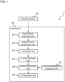
- Fig. 1 is a block diagram illustrating a configuration of an information processing device 1 according to this embodiment.
- the information processing device 1 includes a ranging sensor 10 (sensor), and a controller 20.
- the information processing device 1 may be installed in a vehicle that has an automatic driving function, or may be installed in a vehicle that does not have an automatic driving function. Further, the information processing device 1 may be installed in a vehicle that can switch between automatic driving and manual driving. Furthermore, the automatic driving function may be a driving assistance function that automatically controls only some of the vehicle control functions, such as steering control, braking force control, and driving force control, to support the driver's driving. In this embodiment, the information processing device 1 will be described as being installed in a vehicle having an automatic driving function.
- the information processing device 1 may control various actuators such as a steering actuator, an accelerator pedal actuator, and a brake actuator based on the recognition results (position, shape, posture, etc. of an object) by the attribute information setting unit 24. This makes it possible to realize highly accurate automated driving.
- the ranging sensor 10 includes a sensor that mainly measures the distance and direction to objects around the vehicle by emitting electromagnetic waves from an emission point around the vehicle and detecting the position of a reflection point based on the reflected waves of the emitted electromagnetic waves.
- An example of such a sensor is a lidar (LIDAR: Laser Imaging Detection and Ranging).
- the lidar is a sensor that emits light (laser light) from the emission point to a predetermined range around the vehicle, detects the position of the reflection point (ranging point) based on the reflected wave, and generates point cloud data regarding the ranging point.
- the lidar is a device that measures the distance and direction to an object and recognizes the shape of objects by emitting light (laser light) to objects around the vehicle and measuring the time it takes for the light (reflected light) to hit the object and bounce back. Furthermore, the lidar can also acquire three-dimensional positional relationships between objects. Note that it is also possible to perform mapping using the intensity of reflected light.
- the lidar scans the surroundings of the vehicle in the main scanning direction and the sub scanning direction by changing the direction of light irradiation. As a result, light is sequentially irradiated to a plurality of ranging points around the vehicle. A round of irradiation of light to all ranging points around the vehicle is repeated at predetermined time intervals.
- the lidar generates information for each ranging point (ranging point information) acquired by irradiating light. Then, the lidar outputs point cloud data consisting of a plurality of ranging point information to the controller 20.
- the ranging point information includes position information of the ranging point.
- the position information is information indicating the position coordinates of the ranging point.
- a polar coordinate system may be used for the position coordinates, which is expressed by the direction from the lidar to the ranging point (yaw angle, pitch angle) and the distance (depth) from the lidar to the ranging point.
- a three-dimensional coordinate system expressed by x coordinate, y coordinate, and z coordinate with the origin at the installation position of the lidar may be used.
- the ranging point information may include time information of the ranging point.
- the time information is information indicating the time when the position information of the ranging point was generated (the reflected electromagnetic wave was received).
- the ranging point information may include information on the intensity of reflected light from the ranging point (intensity information).
- the controller 20 is a general-purpose microcomputer that includes a CPU (central processing unit), memory, and an input/output unit.
- a computer program for functioning as the information processing device 1 is installed in the microcomputer. By executing the computer program, the microcomputer functions as a plurality of information processing circuits included in the information processing device 1.
- the controller 20 processes data acquired from the ranging sensor 10.
- a plurality of information processing circuits included in the information processing device 1 are realized by software.
- a plurality of information processing circuits may be configured by individual hardware.
- the controller 20 includes a point cloud acquiring unit 21, a ranging point extracting unit 23, a clustering unit 25, a cluster tracking unit 27, a speed calculating unit 29, a vehicle information acquiring unit 31, and a determining unit 33, as examples of a plurality of information processing circuits (information processing functions).
- the controller 20 may be expressed as an ECU (Electronic Control Unit).
- the point cloud acquiring unit 21 acquires point cloud data from the ranging sensor 10.
- the ranging point extracting unit 23 extracts ranging points of three-dimensional objects existing around the vehicle, excluding ranging points on the road surface on which the vehicle travels, based on the point cloud data.
- the clustering unit 25 classifies (clusters) a plurality of ranging points regarding the three-dimensional objects into a plurality of clusters based on the distance between each point. More specifically, the clustering unit 25 performs a process of classifying a set of ranging points whose distances to adjacent ranging points are less than or equal to a predetermined value as a cluster of ranging points related to one object. Therefore, each cluster is made up of ranging points that are within a predetermined distance from each other. Note that the predetermined distance may be set in advance, or may be set as appropriate based on the surrounding situation of the vehicle, the speed of the vehicle, and the like.
- the clustering unit 25 may calculate the size of each cluster based on information on the ranging points within the cluster. Then, if the calculated size of cluster is within a preset range corresponding to the pre-registered target object, the clustering unit 25 may set the registered target object as a candidate for the cluster.
- Fig. 3A is a schematic diagram showing the positional relationship between a ranging sensor 10 and a ranging point on a surface of a curb.
- Fig. 3B is a schematic diagram showing the relationship between the ranging points on the surface of the curb and clusters.
- the area through which the electromagnetic waves emitted from the emission point of the ranging sensor 10 passes is expressed as a cone BL.
- the emission point of the ranging sensor 10 is located at the apex of the cone BL, and the emitted electromagnetic waves pass through the surface of the cone BL.
- a plurality of ranging points P located at locations where the cone BL and the surface of the curb LS intersect are indicated by black dots.
- Fig. 3B the intersection of the cones BL1 to BL5, which indicate the areas through which the electromagnetic waves emitted from the emission point of the ranging sensor 10 pass, and the plane including the side surface of the curb LS is indicated by a solid line (curved line). Furthermore, the ranging point corresponding to the curb LS is indicated by a black dot. Note that it is assumed that the side surface of the curb LS is perpendicular to the road surface on which the vehicle travels.
- the electromagnetic waves indicated by the cones BL1 to BL5 have different pitch angles (vertical inclination angles with respect to the horizontal plane) when emitted from the emission point of the ranging sensor 10.
- the pitch angle in the propagating direction of the electromagnetic waves corresponding to the cone BL1 is the largest, and the pitch angle in the propagating direction of the electromagnetic waves corresponding to the cones becomes smaller in the order of cones BL2, BL3, BL4, and BL5.
- the ranging points belonging to cone BL1 and cone BL2 are classified as cluster CL1, and the ranging points belonging to cone BL3 are classified as cluster CL2, which is different from cluster CL1.
- the ranging points belonging to cluster CL1 and the ranging points belonging to cluster CL2 are both ranging points corresponding to the curb LS, so the ranging points belonging to cluster CL1 and the ranging points belonging to cluster CL1 should be classified into the same cluster, originally.
- the curb LS is located far from the emission point of the ranging sensor 10 and the density of the ranging points at the position of the curb LS is not sufficient, a problem may occur in which ranging points for the same target object are classified into different clusters, as shown in Fig. 3B .
- the cluster tracking unit 27 and the determining unit 33 which will be described later, perform processing to reduce the possibility of erroneously recognizing cluster CL1 and cluster CL2 as moving objects.
- the cluster tracking unit 27 determines whether each cluster at two consecutive time points (first timing and second timing) belongs to the same object based on the clustering results (cluster position, shape, etc.) for the ranging points at both timings. For example, the cluster tracking unit 27 acquires the moving direction of the ranging points included in the cluster from the first timing to the second timing.
- the cluster tracking unit 27 acquires the height of the ranging points included in the cluster.
- the cluster tracking unit 27 may calculate a representative value (for example, an average value) of the height of the ranging points based on a predetermined ratio or more of the ranging points included in the cluster, and may acquire the representative value as the height of the cluster.
- the cluster tracking unit 27 acquires the arrangement direction of the ranging points included in the cluster. More specifically, the cluster tracking unit 27 calculates the positions of the ranging points included in the cluster projected onto the road surface, and acquires the arrangement directions on a two-dimensional plane parallel to the road surface for the plurality of positions acquired by projecting the plurality of the ranging points. The cluster tracking unit 27 may acquire the arrangement direction based on a predetermined ratio or more of the ranging points among the ranging points included in the cluster.
- the cluster tracking unit 27 acquires the height of the ranging points and the arrangement direction of the ranging points at at least one of the first timing and the second timing.
- the cluster tracking unit 27 acquires the distance from the emission point where electromagnetic waves are emitted to the ranging point to the cluster.
- the cluster tracking unit 27 acquires the distance from the emission point to the cluster at the first timing as a first distance, and acquires the distance from the emission point to the cluster at the second timing as a second distance.
- the cluster tracking unit 27 acquires, for each cluster, the height of the cluster, the arrangement direction in which the ranging points in the cluster are arranged, and the distance from the emission point to the cluster.
- the vehicle information acquiring unit 31 acquires the position, speed, and moving direction of the vehicle.
- the vehicle information acquiring unit 31 may acquire the vehicle position using the GPS receiver or the GNSS receiver (not shown), or may acquire the vehicle condition using a speed sensor, an acceleration sensor, a steering angle sensor, a gyro sensor, a brake oil pressure sensor, an accelerator opening sensor, etc.
- the speed calculating unit 29 calculates, for each cluster, the expected moving speed when the cluster is a cluster consisting of ranging points corresponding to curb stones.
- V is the magnitude of the moving speed of the ranging sensor 10
- ⁇ is the angle between the moving direction of the ranging sensor 10 and the arrangement direction of the ranging points included in the cluster
- ⁇ is the yaw angle (azimuth angle) of the cluster with respect to the ranging sensor 10.
- the moving speed of the ranging sensor 10 is calculated based on the speed of the vehicle and the steering angle.
- the yaw angle of the cluster is, for example, the average value of the yaw angles of the ranging points included in the cluster, or the yaw angle of the representative point of the cluster calculated based on the ranging points included in the cluster.
- Fig. 4A is a first plan view showing an example of the positional relationship between the curb and the ranging sensor 10.
- Fig. 4B is a second plan view showing an example of the positional relationship between the curb and the ranging sensor 10.
- Fig. 4C is a third plan view showing an example of the positional relationship between the curb and the ranging sensor 10.
- the distance traveled by the ranging sensor 10 during unit time ⁇ t is indicated by "V ⁇ t "
- the distance traveled by the cluster during unit time ⁇ t is indicated by "W ⁇ t”.
- the angle formed by the moving direction of the ranging sensor 10 and the arrangement direction of the ranging points included in the cluster is indicated by “ ⁇ ”
- the yaw angle of the cluster with respect to the ranging sensor 10 is indicated by " ⁇ ”.
- the distance from the ranging sensor 10 to the cluster (more precisely, the distance in a plane parallel to the road surface) is indicated by "r”.
- the circle C1 and the circle C2 are circles with a radius r, the emission point of the ranging sensor 10 located at the center of the circle C1 is shown as being located at the center of the circle C2 after a unit time ⁇ t has elapsed.
- W ⁇ t is estimated by the sum of "W x ⁇ t” and "W y ⁇ t".
- W x ⁇ t is the moving distance of the cluster caused by the distance "V x ⁇ t” that the ranging sensor 10 moves in a direction parallel to the curb LS during the unit time ⁇ t.
- W y ⁇ t is the moving distance of the cluster caused by the distance "V y ⁇ t” that the ranging sensor 10 travels in the direction perpendicular to the curb LS during the unit time ⁇ t.
- Fig. 4C the ranging sensor 10 is shown moving in a direction perpendicular to the curb LS.
- the magnitude of the moving speed of the cluster consisting of the ranging points corresponding to the curb is expressed by the above equation (1).
- the expected moving speed is calculated based on equation (1) for the cluster actually acquired from the point cloud data, and if the expected moving speed is close to the actual moving speed, it can be determined that there is a high possibility that the cluster corresponds to the curb.
- the determining unit 33 determines whether a condition indicating "curb-likeness" is satisfied for each cluster.
- a condition indicating "curb-likeness" is satisfied for each cluster.
- the following conditions can be cited as conditions that indicate "curb-likeness”.
- a height condition is set that the height of the ranging points included in the cluster from the road surface on which the vehicle is traveling is equal to or lower than a predetermined height at at least one of the first timing and the second timing.
- the curb on the road surface is often below a certain height. Therefore, a cluster that satisfies the height condition is likely to correspond to the curb.
- An arrangement condition is set that the positions of the ranging points included in the cluster projected onto the road surface are arranged along the moving direction of the cluster at at least one of the first timing and the second timing.
- a deviation condition is set that the difference between the first distance from the emission point to the cluster at the first timing and the second distance from the emission point to the cluster at the second timing is equal to or smaller than a predetermined value.
- the distance from the emission point to the clusters corresponding to the curbs does not vary significantly. Therefore, a cluster that satisfies the deviation condition is likely to correspond to the curb.
- a continuation condition is set that the arrangement direction of the positions of the ranging points included in the cluster projected onto the road surface at the first timing is the same as the arrangement direction of the positions of the ranging points included in the cluster projected onto the road surface at the second timing.
- the arrangement direction of the ranging points included in the cluster corresponding to the curb does not vary significantly. Therefore, a cluster that satisfies the continuation condition is likely to correspond to the curb.
- a continuation condition may be set that the height of the ranging points included in the cluster at the first timing is the same as the height of the ranging points included in the cluster at the second timing.
- the height of the ranging points included in the cluster corresponding to the curb does not vary significantly. Therefore, a cluster that satisfies the continuation condition is likely to correspond to the curb.
- a speed condition is set that the difference between the moving speed estimated based on equation (1) for the cluster actually obtained from point cloud data and the actual moving speed of the cluster is equal to or less than a predetermined threshold (i.e., the two moving speeds are equal or have a small difference).
- a predetermined threshold i.e., the two moving speeds are equal or have a small difference.
- the determining unit 33 determines whether the above-described condition indicating "curb-likeness" is satisfied for each cluster. More specifically, the determining unit 33 determines whether all of the primary conditions consisting of the height condition, the arrangement condition, and the deviation condition are satisfied. If it is determined that all of the primary conditions are satisfied, the determining unit 33 recognizes the cluster as the curb on the road surface.
- the determining unit 33 may recognize the cluster as the curb on the road surface when it is determined that the continuation condition is satisfied in addition to all of the primary conditions. Further, the determining unit 33 may recognize the cluster as the curb on the road surface when it is determined that the speed condition is satisfied in addition to all of the primary conditions. Furthermore, the determining unit 33 may recognize the cluster as the curb on the road surface when it is determined that other conditions are satisfied in addition to all of the primary conditions.
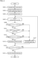
- Fig. 2 is a flowchart illustrating a processing of the information processing device 1 according to this embodiment.
- the process of the information processing device 1 shown in Fig. 2 may be repeatedly executed at a predetermined cycle.
- step S101 the point cloud acquiring unit 21 acquires point cloud data from the ranging sensor 10.
- step S103 the ranging point extracting unit 23 extracts ranging points of three-dimensional objects existing around the vehicle, excluding ranging points on the road surface on which the vehicle travels, based on the point cloud data.
- step S105 the clustering unit 25 classifies (clusters) a plurality of ranging points regarding the three-dimensional objects into a plurality of clusters based on the distance between each point.
- the cluster tracking unit 27 acquires various types of information regarding clusters and ranging points included in the clusters.
- step S107 the determining unit 33 selects unprocessed clusters from among the clusters obtained by the clustering unit 25.
- the determining unit 33 determines for each cluster whether the condition indicating "curb-likeness" is satisfied.
- step S109 the determining unit 33 determines whether the height condition is satisfied.
- step S111 the determining unit 33 determines whether the arrangement condition is satisfied.
- step S113 the determining unit 33 determines whether the deviation condition is satisfied.
- the determining unit 33 may determine whether the continuation condition, the speed condition, or other conditions are satisfied.
- step S117 the determining unit 33 recognizes the selected cluster as a cluster corresponding to something other than the curb.
- step S115 the determining unit 33 recognizes the selected cluster as a cluster corresponding to the curb.
- step S119 it is determined whether the determining unit 33 has completed the determination processing for all clusters. If it is determined that all clusters have not been processed (NO in step S119), the process returns to step S107.
- step S119 if it is determined that all clusters have been processed (YES in step S119), the recognition result by the determining unit 33 is output from the input/output unit of the controller 20 in step S121. After that, the flowchart of Fig. 2 ends.
- an information processing method and an information processing device generate a cluster made up of the ranging point that are within a predetermined distance from each other, based on a point cloud data generated by emitting electromagnetic waves from an emission point within a predetermined range around a vehicle and detecting a position of reflection point, which is a ranging point, based on reflected waves, detect a moving direction of the ranging point included in the cluster from a first timing to a second timing, set a height condition that a height of the ranging point included in the cluster from a road surface on which the vehicle is traveling is equal to or lower than a predetermined height at at least one of the first timing and the second timing, set an arrangement condition that the position of the ranging point included in the cluster projected onto the road surface are arranged along the moving direction at at least one of the first timing and the second timing, set a deviation condition that a difference between a first distance from the emission point to the cluster at the first timing and a second distance from the emission point to the cluster at
- the magnitude of the moving speed of the cluster corresponding to the curb is determined by the above equation from the moving speed of the sensor, the angle of the curb with respect to the moving direction of the sensor, and the azimuth angle of the ranging points included in the cluster. Therefore, by adding the speed condition to the determination, it is possible to reduce the possibility that the moving object is mistakenly determined to be the curb.
- the information processing method and the information processing device may recognize the cluster as the curb on the road surface, in a case of determining that all of the primary conditions are satisfied and determining that all of the primary conditions are satisfied after the vehicle accelerates or decelerates. If the magnitude of the moving speed of the cluster satisfies the above-mentioned condition at multiple points in time when the speed of the vehicle is different, there is a high possibility that the cluster corresponds to the curb. Therefore, by determining the above-mentioned conditions even after acceleration or deceleration of the vehicle, it is possible to reduce the possibility that the moving object is mistakenly determined to be the curb.
- the information processing method and the information processing device may recognize two or more clusters as the curb on the road surface, in a case of determining that all of the primary conditions are satisfied for the clusters.
- the above-mentioned conditions are likely to be satisfied in multiple clusters. Therefore, by determining that the above-mentioned condition is satisfied in a plurality of clusters, it is possible to reduce the possibility that the moving object is mistakenly determined to be the curb.
- Respective functions described in the above embodiment may be implemented by one or plural processing circuits.
- the processing circuits include programmed processors, electrical circuits, etc., as well as devices such as application specific integrated circuits (ASIC) and circuit components arranged to perform the described functions, etc.
- ASIC application specific integrated circuits
Landscapes
- Engineering & Computer Science (AREA)
- Physics & Mathematics (AREA)
- General Physics & Mathematics (AREA)
- Remote Sensing (AREA)
- Computer Networks & Wireless Communication (AREA)
- Radar, Positioning & Navigation (AREA)
- Theoretical Computer Science (AREA)
- Electromagnetism (AREA)
- Multimedia (AREA)
- Data Mining & Analysis (AREA)
- Computer Vision & Pattern Recognition (AREA)
- Artificial Intelligence (AREA)
- Evolutionary Computation (AREA)
- Health & Medical Sciences (AREA)
- Computing Systems (AREA)
- Databases & Information Systems (AREA)
- General Health & Medical Sciences (AREA)
- Medical Informatics (AREA)
- Software Systems (AREA)
- Bioinformatics & Computational Biology (AREA)
- Evolutionary Biology (AREA)
- Bioinformatics & Cheminformatics (AREA)
- General Engineering & Computer Science (AREA)
- Life Sciences & Earth Sciences (AREA)
- Traffic Control Systems (AREA)
Abstract
Description
- The present invention relates to an information processing method and an information processing device.
- A technology has been proposed that processes distance data (distance and direction) obtained by a scanning laser radar, and determines whether a moving object is a pedestrian or not based on the size and speed of the moving object recognized based on the distance data (Patent Literature 1).
- Patent Literature 1:
Japanese Patent Laid-Open Publication No. 2006-160116 - According to the technology described in
Patent Literature 1, objects are discriminated only based on the size and speed of moving objects, so if the density of ranging points around the vehicle obtained by scanning using a sensor is not sufficient, stationary structures such as curbs may be mistaken for moving objects. - The present invention has been made in view of the above problems. An object of the present invention is to provide an information processing method and an information processing device that can reduce the possibility of misidentifying stationary structures such as curbs for moving objects even if the density of ranging points around the vehicle obtained by scanning using a sensor is not sufficient.
- In order to solve the above-described problems, an information processing method and an information processing device, according to an aspect of the present invention, generate a cluster made up of ranging points that are within a predetermined distance from each other, based on a point cloud data, detect a moving direction of the ranging point included in the cluster from a first timing to a second timing, set a height condition that a height of the ranging point included in the cluster from a road surface on which a vehicle is traveling is equal to or lower than a predetermined height at at least one of the first timing and the second timing, set an arrangement condition that a position of the ranging point included in the cluster projected onto the road surface are arranged along the moving direction at at least one of the timings, set a deviation condition that a difference between a first distance to the cluster at the first timing and a second distance to the cluster at the second timing is equal to or smaller than a predetermined value, and recognize the cluster as a curb on the road surface, in a case of determining that all of the primary conditions including the height condition, the arrangement condition, and the deviation condition, are satisfied.
- According to the present invention, it is possible to reduce the possibility of misidentifying stationary structures such as curbs for moving objects even if the density of ranging points around the vehicle obtained by scanning using a sensor is not sufficient.
-
- [
Fig. 1] Fig. 1 is a block diagram illustrating a configuration of aninformation processing device 1 according to an embodiment of the present invention. - [
Fig. 2] Fig. 2 is a flowchart illustrating a processing of theinformation processing device 1 according to the embodiment of the present invention. - [
Fig. 3A] Fig. 3A is a schematic diagram showing the positional relationship between a rangingsensor 10 and a ranging point on a surface of a curb. - [
Fig. 3B] Fig. 3B is a schematic diagram showing the relationship between the ranging points on the surface of the curb and clusters. - [
Fig. 4A] Fig. 4A is a first plan view showing an example of the positional relationship between the curb and the rangingsensor 10. - [
Fig. 4B] Fig. 4B is a second plan view showing an example of the positional relationship between the curb and the rangingsensor 10. - [
Fig. 4C] Fig. 4C is a third plan view showing an example of the positional relationship between the curb and the rangingsensor 10. - Hereinafter, embodiments of the present invention will be described with reference to the drawings. In the description of the drawings, the same items are designated by the same reference numerals and duplicate description will be omitted.
- An example of the configuration of an
information processing device 1 will be described with reference toFig. 1. Fig. 1 is a block diagram illustrating a configuration of aninformation processing device 1 according to this embodiment. As shown inFig. 1 , theinformation processing device 1 includes a ranging sensor 10 (sensor), and acontroller 20. - The
information processing device 1 may be installed in a vehicle that has an automatic driving function, or may be installed in a vehicle that does not have an automatic driving function. Further, theinformation processing device 1 may be installed in a vehicle that can switch between automatic driving and manual driving. Furthermore, the automatic driving function may be a driving assistance function that automatically controls only some of the vehicle control functions, such as steering control, braking force control, and driving force control, to support the driver's driving. In this embodiment, theinformation processing device 1 will be described as being installed in a vehicle having an automatic driving function. - Although omitted in
Fig. 1 , theinformation processing device 1 may control various actuators such as a steering actuator, an accelerator pedal actuator, and a brake actuator based on the recognition results (position, shape, posture, etc. of an object) by the attribute information setting unit 24. This makes it possible to realize highly accurate automated driving. - The ranging
sensor 10 includes a sensor that mainly measures the distance and direction to objects around the vehicle by emitting electromagnetic waves from an emission point around the vehicle and detecting the position of a reflection point based on the reflected waves of the emitted electromagnetic waves. An example of such a sensor is a lidar (LIDAR: Laser Imaging Detection and Ranging). The lidar is a sensor that emits light (laser light) from the emission point to a predetermined range around the vehicle, detects the position of the reflection point (ranging point) based on the reflected wave, and generates point cloud data regarding the ranging point. The lidar is a device that measures the distance and direction to an object and recognizes the shape of objects by emitting light (laser light) to objects around the vehicle and measuring the time it takes for the light (reflected light) to hit the object and bounce back. Furthermore, the lidar can also acquire three-dimensional positional relationships between objects. Note that it is also possible to perform mapping using the intensity of reflected light. - For example, the lidar scans the surroundings of the vehicle in the main scanning direction and the sub scanning direction by changing the direction of light irradiation. As a result, light is sequentially irradiated to a plurality of ranging points around the vehicle. A round of irradiation of light to all ranging points around the vehicle is repeated at predetermined time intervals. The lidar generates information for each ranging point (ranging point information) acquired by irradiating light. Then, the lidar outputs point cloud data consisting of a plurality of ranging point information to the
controller 20. - The ranging point information includes position information of the ranging point. The position information is information indicating the position coordinates of the ranging point. A polar coordinate system may be used for the position coordinates, which is expressed by the direction from the lidar to the ranging point (yaw angle, pitch angle) and the distance (depth) from the lidar to the ranging point. For the position coordinates, a three-dimensional coordinate system expressed by x coordinate, y coordinate, and z coordinate with the origin at the installation position of the lidar may be used. Further, the ranging point information may include time information of the ranging point. The time information is information indicating the time when the position information of the ranging point was generated (the reflected electromagnetic wave was received). In addition, the ranging point information may include information on the intensity of reflected light from the ranging point (intensity information).
- The
controller 20 is a general-purpose microcomputer that includes a CPU (central processing unit), memory, and an input/output unit. A computer program for functioning as theinformation processing device 1 is installed in the microcomputer. By executing the computer program, the microcomputer functions as a plurality of information processing circuits included in theinformation processing device 1. Thecontroller 20 processes data acquired from the rangingsensor 10. - Here, an example is shown in which a plurality of information processing circuits included in the
information processing device 1 are realized by software. However, it is also possible to configure information processing circuits by preparing dedicated hardware for executing each of the following information processing. Further, a plurality of information processing circuits may be configured by individual hardware. - The
controller 20 includes a pointcloud acquiring unit 21, a rangingpoint extracting unit 23, aclustering unit 25, a cluster tracking unit 27, aspeed calculating unit 29, a vehicleinformation acquiring unit 31, and a determiningunit 33, as examples of a plurality of information processing circuits (information processing functions). Note that thecontroller 20 may be expressed as an ECU (Electronic Control Unit). - The point
cloud acquiring unit 21 acquires point cloud data from the rangingsensor 10. - The ranging
point extracting unit 23 extracts ranging points of three-dimensional objects existing around the vehicle, excluding ranging points on the road surface on which the vehicle travels, based on the point cloud data. - The
clustering unit 25 classifies (clusters) a plurality of ranging points regarding the three-dimensional objects into a plurality of clusters based on the distance between each point. More specifically, theclustering unit 25 performs a process of classifying a set of ranging points whose distances to adjacent ranging points are less than or equal to a predetermined value as a cluster of ranging points related to one object. Therefore, each cluster is made up of ranging points that are within a predetermined distance from each other. Note that the predetermined distance may be set in advance, or may be set as appropriate based on the surrounding situation of the vehicle, the speed of the vehicle, and the like. - In addition, the
clustering unit 25 may calculate the size of each cluster based on information on the ranging points within the cluster. Then, if the calculated size of cluster is within a preset range corresponding to the pre-registered target object, theclustering unit 25 may set the registered target object as a candidate for the cluster. - An aspect of clustering by the
clustering unit 25 will be explained usingFigs. 3A and 3B. Fig. 3A is a schematic diagram showing the positional relationship between a rangingsensor 10 and a ranging point on a surface of a curb.Fig. 3B is a schematic diagram showing the relationship between the ranging points on the surface of the curb and clusters. - In
Fig. 3A , the area through which the electromagnetic waves emitted from the emission point of the rangingsensor 10 passes is expressed as a cone BL. The emission point of the rangingsensor 10 is located at the apex of the cone BL, and the emitted electromagnetic waves pass through the surface of the cone BL. Further, a plurality of ranging points P located at locations where the cone BL and the surface of the curb LS intersect are indicated by black dots. - In
Fig. 3B , the intersection of the cones BL1 to BL5, which indicate the areas through which the electromagnetic waves emitted from the emission point of the rangingsensor 10 pass, and the plane including the side surface of the curb LS is indicated by a solid line (curved line). Furthermore, the ranging point corresponding to the curb LS is indicated by a black dot. Note that it is assumed that the side surface of the curb LS is perpendicular to the road surface on which the vehicle travels. - The electromagnetic waves indicated by the cones BL1 to BL5 have different pitch angles (vertical inclination angles with respect to the horizontal plane) when emitted from the emission point of the ranging
sensor 10. The pitch angle in the propagating direction of the electromagnetic waves corresponding to the cone BL1 is the largest, and the pitch angle in the propagating direction of the electromagnetic waves corresponding to the cones becomes smaller in the order of cones BL2, BL3, BL4, and BL5. - In
Fig. 3B , the ranging points belonging to cone BL1 and cone BL2 are classified as cluster CL1, and the ranging points belonging to cone BL3 are classified as cluster CL2, which is different from cluster CL1. The ranging points belonging to cluster CL1 and the ranging points belonging to cluster CL2 are both ranging points corresponding to the curb LS, so the ranging points belonging to cluster CL1 and the ranging points belonging to cluster CL1 should be classified into the same cluster, originally. However, when the curb LS is located far from the emission point of the rangingsensor 10 and the density of the ranging points at the position of the curb LS is not sufficient, a problem may occur in which ranging points for the same target object are classified into different clusters, as shown inFig. 3B . - Furthermore, since the cluster CL1 and the cluster CL2 shown in
Fig. 3B move along the curb LS with the movement of the vehicle, they appear to have movements similar to those of pedestrians or small animals. Thus, if an attempt is made to recognize target objects corresponding to clusters based only on the size and speed of the clusters, there is a risk that the cluster CL1 and the cluster CL2 may be mistakenly recognized as moving objects. Therefore, the cluster tracking unit 27 and the determiningunit 33, which will be described later, perform processing to reduce the possibility of erroneously recognizing cluster CL1 and cluster CL2 as moving objects. - The cluster tracking unit 27 determines whether each cluster at two consecutive time points (first timing and second timing) belongs to the same object based on the clustering results (cluster position, shape, etc.) for the ranging points at both timings. For example, the cluster tracking unit 27 acquires the moving direction of the ranging points included in the cluster from the first timing to the second timing.
- Furthermore, the cluster tracking unit 27 acquires the height of the ranging points included in the cluster. The cluster tracking unit 27 may calculate a representative value (for example, an average value) of the height of the ranging points based on a predetermined ratio or more of the ranging points included in the cluster, and may acquire the representative value as the height of the cluster.
- Furthermore, the cluster tracking unit 27 acquires the arrangement direction of the ranging points included in the cluster. More specifically, the cluster tracking unit 27 calculates the positions of the ranging points included in the cluster projected onto the road surface, and acquires the arrangement directions on a two-dimensional plane parallel to the road surface for the plurality of positions acquired by projecting the plurality of the ranging points. The cluster tracking unit 27 may acquire the arrangement direction based on a predetermined ratio or more of the ranging points among the ranging points included in the cluster.
- The cluster tracking unit 27 acquires the height of the ranging points and the arrangement direction of the ranging points at at least one of the first timing and the second timing.
- In addition, the cluster tracking unit 27 acquires the distance from the emission point where electromagnetic waves are emitted to the ranging point to the cluster. Here, the cluster tracking unit 27 acquires the distance from the emission point to the cluster at the first timing as a first distance, and acquires the distance from the emission point to the cluster at the second timing as a second distance.
- The cluster tracking unit 27 acquires, for each cluster, the height of the cluster, the arrangement direction in which the ranging points in the cluster are arranged, and the distance from the emission point to the cluster.
- The vehicle
information acquiring unit 31 acquires the position, speed, and moving direction of the vehicle. For example, the vehicleinformation acquiring unit 31 may acquire the vehicle position using the GPS receiver or the GNSS receiver (not shown), or may acquire the vehicle condition using a speed sensor, an acceleration sensor, a steering angle sensor, a gyro sensor, a brake oil pressure sensor, an accelerator opening sensor, etc. - The
speed calculating unit 29 calculates, for each cluster, the expected moving speed when the cluster is a cluster consisting of ranging points corresponding to curb stones. The size W of the assumed moving speed of the cluster is calculated by the following equation (1).
[Equation 1]
sensor 10, θ is the angle between the moving direction of the rangingsensor 10 and the arrangement direction of the ranging points included in the cluster, and φ is the yaw angle (azimuth angle) of the cluster with respect to the rangingsensor 10. Note that the moving speed of the rangingsensor 10 is calculated based on the speed of the vehicle and the steering angle. Further, the yaw angle of the cluster is, for example, the average value of the yaw angles of the ranging points included in the cluster, or the yaw angle of the representative point of the cluster calculated based on the ranging points included in the cluster. - The reason why the magnitude of the moving speed of the cluster consisting of the ranging points corresponding to the curb is expressed by the above equation (1) will be explained using
Figs. 4A, 4B, and 4C. Fig. 4A is a first plan view showing an example of the positional relationship between the curb and the rangingsensor 10.Fig. 4B is a second plan view showing an example of the positional relationship between the curb and the rangingsensor 10.Fig. 4C is a third plan view showing an example of the positional relationship between the curb and the rangingsensor 10. - In
Fig. 4A , the distance traveled by the rangingsensor 10 during unit time Δt is indicated by "VΔt ", and the distance traveled by the cluster during unit time Δt is indicated by "WΔt". Further, the angle formed by the moving direction of the rangingsensor 10 and the arrangement direction of the ranging points included in the cluster is indicated by "θ", and the yaw angle of the cluster with respect to the rangingsensor 10 is indicated by "φ". In addition, the distance from the rangingsensor 10 to the cluster (more precisely, the distance in a plane parallel to the road surface) is indicated by "r". The circle C1 and the circle C2 are circles with a radius r, the emission point of the rangingsensor 10 located at the center of the circle C1 is shown as being located at the center of the circle C2 after a unit time Δt has elapsed. - "WΔt " is estimated by the sum of "WxΔt" and "WyΔt". Here, "WxΔt" is the moving distance of the cluster caused by the distance "VxΔt" that the ranging
sensor 10 moves in a direction parallel to the curb LS during the unit time Δt. Moreover, "WyΔt" is the moving distance of the cluster caused by the distance "VyΔt" that the rangingsensor 10 travels in the direction perpendicular to the curb LS during the unit time Δt. - In
Fig. 4B , the rangingsensor 10 is shown moving in a direction parallel to the curb LS. From the positional relationship between the circle C1 and the circle C2 shown inFig. 4B , the following equation (2) is established between "WxΔt" and "VxΔt".
[Equation 2]
- In
Fig. 4C , the rangingsensor 10 is shown moving in a direction perpendicular to the curb LS. InFig. 4C , "α" satisfies "α+θ+φ=π/2". From the positional relationship between the circle C1 and the circle C2 shown inFig. 4C , the following equation (3) is established between "WyΔt" and "VyΔt".
[Equation 3]
- Note that when formula (3) is derived, "α+θ+φ=π/2" and the fact that "r" is sufficiently larger than "VΔt" are used.
- Therefore, by dividing the sum of "WxΔt" shown by equation (2) and "WyΔt" shown by equation (3) by "Δt", "W" shown by equation (1) is obtained.
- Therefore, it has been shown that the magnitude of the moving speed of the cluster consisting of the ranging points corresponding to the curb is expressed by the above equation (1). The expected moving speed is calculated based on equation (1) for the cluster actually acquired from the point cloud data, and if the expected moving speed is close to the actual moving speed, it can be determined that there is a high possibility that the cluster corresponds to the curb.
- The determining
unit 33 determines whether a condition indicating "curb-likeness" is satisfied for each cluster. Here, the following conditions can be cited as conditions that indicate "curb-likeness". - A height condition is set that the height of the ranging points included in the cluster from the road surface on which the vehicle is traveling is equal to or lower than a predetermined height at at least one of the first timing and the second timing. The curb on the road surface is often below a certain height. Therefore, a cluster that satisfies the height condition is likely to correspond to the curb.
- An arrangement condition is set that the positions of the ranging points included in the cluster projected onto the road surface are arranged along the moving direction of the cluster at at least one of the first timing and the second timing. The arrangement direction of the positions of the ranging points included in the cluster corresponding to the curb, projected onto the road surface, coincides with the moving direction of the cluster. Therefore, a cluster that satisfies the arrangement condition is likely to correspond to the curb.
- A deviation condition is set that the difference between the first distance from the emission point to the cluster at the first timing and the second distance from the emission point to the cluster at the second timing is equal to or smaller than a predetermined value. The distance from the emission point to the clusters corresponding to the curbs does not vary significantly. Therefore, a cluster that satisfies the deviation condition is likely to correspond to the curb.
- A continuation condition is set that the arrangement direction of the positions of the ranging points included in the cluster projected onto the road surface at the first timing is the same as the arrangement direction of the positions of the ranging points included in the cluster projected onto the road surface at the second timing. The arrangement direction of the ranging points included in the cluster corresponding to the curb does not vary significantly. Therefore, a cluster that satisfies the continuation condition is likely to correspond to the curb.
- Note that a continuation condition may be set that the height of the ranging points included in the cluster at the first timing is the same as the height of the ranging points included in the cluster at the second timing. The height of the ranging points included in the cluster corresponding to the curb does not vary significantly. Therefore, a cluster that satisfies the continuation condition is likely to correspond to the curb.
- A speed condition is set that the difference between the moving speed estimated based on equation (1) for the cluster actually obtained from point cloud data and the actual moving speed of the cluster is equal to or less than a predetermined threshold (i.e., the two moving speeds are equal or have a small difference). As described above, the magnitude of the moving speed of the cluster corresponding to the curb can be evaluated using equation (1). Therefore, a cluster that satisfies the speed condition is likely to correspond to the curb.
- If one or more of the conditions described above are satisfied at two or more timings, it can be said that there is a high possibility that the cluster is the curb. In particular, if one or more of the conditions described above are satisfied at different vehicle speeds after acceleration or deceleration of the vehicle, it is highly likely that the cluster is the curb.
- Furthermore, if one or more of the conditions described above are satisfied for multiple clusters adjacent to the cluster of interest, there is a high possibility that the cluster of interest and the adjacent clusters are clusters corresponding to the same curb.
- The determining
unit 33 determines whether the above-described condition indicating "curb-likeness" is satisfied for each cluster. More specifically, the determiningunit 33 determines whether all of the primary conditions consisting of the height condition, the arrangement condition, and the deviation condition are satisfied. If it is determined that all of the primary conditions are satisfied, the determiningunit 33 recognizes the cluster as the curb on the road surface. - In addition, the determining
unit 33 may recognize the cluster as the curb on the road surface when it is determined that the continuation condition is satisfied in addition to all of the primary conditions. Further, the determiningunit 33 may recognize the cluster as the curb on the road surface when it is determined that the speed condition is satisfied in addition to all of the primary conditions. Furthermore, the determiningunit 33 may recognize the cluster as the curb on the road surface when it is determined that other conditions are satisfied in addition to all of the primary conditions. - Next, the processing procedure of the
information processing device 1 according to the present embodiment will be described with reference to the flowchart ofFig. 2. Fig. 2 is a flowchart illustrating a processing of theinformation processing device 1 according to this embodiment. The process of theinformation processing device 1 shown inFig. 2 may be repeatedly executed at a predetermined cycle. - First, in step S101, the point
cloud acquiring unit 21 acquires point cloud data from the rangingsensor 10. - In step S103, the ranging
point extracting unit 23 extracts ranging points of three-dimensional objects existing around the vehicle, excluding ranging points on the road surface on which the vehicle travels, based on the point cloud data. - In step S105, the
clustering unit 25 classifies (clusters) a plurality of ranging points regarding the three-dimensional objects into a plurality of clusters based on the distance between each point. In addition, the cluster tracking unit 27 acquires various types of information regarding clusters and ranging points included in the clusters. - In step S107, the determining
unit 33 selects unprocessed clusters from among the clusters obtained by theclustering unit 25. - In steps S109, S111, and S113, the determining
unit 33 determines for each cluster whether the condition indicating "curb-likeness" is satisfied. - For example, in step S109, the determining
unit 33 determines whether the height condition is satisfied. In step S111, the determiningunit 33 determines whether the arrangement condition is satisfied. In step S113, the determiningunit 33 determines whether the deviation condition is satisfied. The determiningunit 33 may determine whether the continuation condition, the speed condition, or other conditions are satisfied. - If it is determined in steps S109, S111, and S113 that the condition indicating "curb-likeness" is not satisfied (NO in any of steps S109, S111, and S113), in step S117, the determining
unit 33 recognizes the selected cluster as a cluster corresponding to something other than the curb. - On the other hand, if it is determined in steps S109, S111, and S113 that the condition indicating "curb-likeness" is satisfied (YES in all of steps S109, S111, and S113), in step S115, the determining
unit 33 recognizes the selected cluster as a cluster corresponding to the curb. - In step S119, it is determined whether the determining
unit 33 has completed the determination processing for all clusters. If it is determined that all clusters have not been processed (NO in step S119), the process returns to step S107. - On the other hand, if it is determined that all clusters have been processed (YES in step S119), the recognition result by the determining
unit 33 is output from the input/output unit of thecontroller 20 in step S121. After that, the flowchart ofFig. 2 ends. - As explained in detail above, an information processing method and an information processing device, according to the present embodiment, generate a cluster made up of the ranging point that are within a predetermined distance from each other, based on a point cloud data generated by emitting electromagnetic waves from an emission point within a predetermined range around a vehicle and detecting a position of reflection point, which is a ranging point, based on reflected waves, detect a moving direction of the ranging point included in the cluster from a first timing to a second timing, set a height condition that a height of the ranging point included in the cluster from a road surface on which the vehicle is traveling is equal to or lower than a predetermined height at at least one of the first timing and the second timing, set an arrangement condition that the position of the ranging point included in the cluster projected onto the road surface are arranged along the moving direction at at least one of the first timing and the second timing, set a deviation condition that a difference between a first distance from the emission point to the cluster at the first timing and a second distance from the emission point to the cluster at the second timing is equal to or smaller than a predetermined value, determine whether all of primary conditions including the height condition, the arrangement condition, and the deviation condition, are satisfied, and recognize the cluster as a curb on the road surface, in a case of determining that all of the primary conditions are satisfied.
- As a result, it is possible to reduce the possibility of misidentifying stationary structures such as curbs for moving objects even if the density of ranging points around the vehicle obtained by scanning using a sensor is not sufficient. In particular, since it is determined whether the cluster is the curb, based on the height of the ranging points that make up the cluster, the similarity between the moving direction of the cluster and the arrangement direction of the ranging points within the cluster, and the temporal change in the distance from the emission point of the sensor, it is possible to reduce the possibility that the curb is mistakenly detected as the moving object.
- Further, the information processing method and the information processing device, according to the present embodiment, may recognize the cluster as the curb on the road surface, in a case of determining that all of the primary conditions are satisfied and an arrangement direction of the position at the first timing is the same as an arrangement direction of the position at the second timing. The arrangement direction of the ranging points included in the cluster corresponding to the curb does not change over time if it is at the same point, and changes slowly in space. Therefore, by adding the arrangement condition to the determination, it is possible to reduce the possibility that the moving object is mistakenly determined to be the curb.
- Furthermore, the information processing method and the information processing device, according to the present embodiment, may recognize the cluster as the curb on the road surface, in a case of determining that all of the primary conditions are satisfied and a height of the ranging point included in the cluster at the first timing is same as a height of the ranging point included in the cluster at the second timing. The height of a cluster corresponding to the curb does not change over time if it is at the same point, and changes slowly in space. Therefore, by adding this condition to the determination, it is possible to reduce the possibility that the moving object is mistakenly determined to be the curb.
- Further, the information processing method and the information processing device, according to the present embodiment, may recognizing the cluster as the curb on the road surface, in a case of determining that all of the primary conditions are satisfied, and a following equation is satisfied,

- Furthermore, the information processing method and the information processing device, according to the present embodiment, may recognize the cluster as the curb on the road surface, in a case of determining that all of the primary conditions are satisfied and determining that all of the primary conditions are satisfied after the vehicle accelerates or decelerates. If the magnitude of the moving speed of the cluster satisfies the above-mentioned condition at multiple points in time when the speed of the vehicle is different, there is a high possibility that the cluster corresponds to the curb. Therefore, by determining the above-mentioned conditions even after acceleration or deceleration of the vehicle, it is possible to reduce the possibility that the moving object is mistakenly determined to be the curb.
- Further, the information processing method and the information processing device, according to the present embodiment, may recognize two or more clusters as the curb on the road surface, in a case of determining that all of the primary conditions are satisfied for the clusters. In the case of spatially continuous curb, the above-mentioned conditions are likely to be satisfied in multiple clusters. Therefore, by determining that the above-mentioned condition is satisfied in a plurality of clusters, it is possible to reduce the possibility that the moving object is mistakenly determined to be the curb.
- Respective functions described in the above embodiment may be implemented by one or plural processing circuits. The processing circuits include programmed processors, electrical circuits, etc., as well as devices such as application specific integrated circuits (ASIC) and circuit components arranged to perform the described functions, etc.
- Although the contents of the present invention have been described above with reference to the embodiment, the present invention is not limited to these descriptions, and it will be apparent to those skilled in the art that various modifications and improvements can be made. It should not be construed that the present invention is limited to the descriptions and the drawings that constitute a part of the present disclosure. On the basis of the present disclosure, various alternative embodiments, practical examples, and operating techniques will be apparent to those skilled in the art.
- It is needless to mention that the present invention also includes various embodiments that are not described herein. Therefore, the technical scope of the present invention is to be defined only by the invention specifying matters according to the scope of claims appropriately obtained from the above descriptions.
-
- 1
- information processing device
- 10
- ranging sensor
- 20
- controller
- 21
- point cloud acquiring unit
- 23
- ranging point extracting unit
- 25
- clustering unit
- 27
- cluster tracking unit
- 29
- speed calculating unit
- 31
- vehicle information acquiring unit
- 33
- determining unit
Claims (7)
- An information processing method foran information processing device including a sensor configured to emit electromagnetic waves from an emission point to a predetermined range around a vehicle, to detect a position of reflection point, which is a ranging point, based on reflected waves, and to generate point cloud data relating to the ranging point, and a controller configured to process data acquired from the sensor,comprising:by using the controller,generating a cluster made up of the ranging point that are within a predetermined distance from each other, based on the point cloud data,detecting a moving direction of the ranging point included in the cluster from a first timing to a second timing,setting a height condition that a height of the ranging point included in the cluster from a road surface on which the vehicle is traveling is equal to or lower than a predetermined height at at least one of the first timing and the second timing,setting an arrangement condition that the position of the ranging point included in the cluster projected onto the road surface are arranged along the moving direction at at least one of the first timing and the second timing,setting a deviation condition that a difference between a first distance from the emission point to the cluster at the first timing and a second distance from the emission point to the cluster at the second timing is equal to or smaller than a predetermined value,determining whether all of primary conditions including the height condition, the arrangement condition, and the deviation condition, are satisfied, andrecognizing the cluster as a curb on the road surface, in a case of determining that all of the primary conditions are satisfied.
- The information processing method according to claim 1, further comprising:
by using the controller, recognizing the cluster as the curb on the road surface, in a case of determining thatall of the primary conditions are satisfied andan arrangement direction of the position at the first timing is the same as an arrangement direction of the position at the second timing. - The information processing method according to claim 1 or 2, further comprising:
by using the controller, recognizing the cluster as the curb on the road surface, in a case of determining thatall of the primary conditions are satisfied anda height of the ranging point included in the cluster at the first timing is same as a height of the ranging point included in the cluster at the second timing. - The information processing method according to any one of claims 1 to 3, further comprising:
by using the controller, recognizing the cluster as the curb on the road surface, in a case of determining thatall of the primary conditions are satisfied, anda following equation is satisfied V is a magnitude of a moving speed of the sensor,θ is an angle between a direction in which the sensor moves and an arrangement direction of the position,φ is an azimuth angle of the cluster relative to the sensor, andW is a magnitude of the moving speed of the cluster.
 - The information processing method according to any one of claims 1 to 4, further comprising:
recognizing the cluster as the curb on the road surface, in a case of
determining that all of the primary conditions are satisfied and determining that all of the primary conditions are satisfied after the vehicle accelerates or decelerates. - The information processing method according to any one of claims 1 to 5, further comprising:
recognizing two or more clusters as the curb on the road surface, in a case of determining that all of the primary conditions are satisfied for the clusters. - An information processing device comprisinga sensor configured to emit electromagnetic waves from an emission point to a predetermined range around a vehicle, to detect a position of reflection point, which is a ranging point, based on reflected waves, and to generate point cloud data relating to the ranging point, anda controller configured to process data acquired from the sensor,wherein the controller is configured togenerate a cluster made up of the ranging point that are within a predetermined distance from each other, based on the point cloud data,detect a moving direction of the ranging point included in the cluster from a first timing to a second timing,set a height condition that a height of the ranging point included in the cluster from a road surface on which the vehicle is traveling is equal to or lower than a predetermined height at at least one of the first timing and the second timing,set an arrangement condition that the position of the ranging point included in the cluster projected onto the road surface are arranged along the moving direction at at least one of the first timing and the second timing,set a deviation condition that a difference between a first distance from the emission point to the cluster at the first timing and a second distance from the emission point to the cluster at the second timing is equal to or smaller than a predetermined value,determine whether all of primary conditions including the height condition, the arrangement condition, and the deviation condition, are satisfied, andrecognize the cluster as a curb on the road surface, in a case of determining that all of the primary conditions are satisfied.
Applications Claiming Priority (1)
| Application Number | Priority Date | Filing Date | Title |
|---|---|---|---|
| PCT/IB2022/000194 WO2023194761A1 (en) | 2022-04-08 | 2022-04-08 | Information processing method and information processing device |
Publications (2)
| Publication Number | Publication Date |
|---|---|
| EP4506222A1 true EP4506222A1 (en) | 2025-02-12 |
| EP4506222A4 EP4506222A4 (en) | 2025-05-28 |
Family
ID=88244139
Family Applications (1)
| Application Number | Title | Priority Date | Filing Date |
|---|---|---|---|
| EP22936424.5A Withdrawn EP4506222A4 (en) | 2022-04-08 | 2022-04-08 | Information processing method and information processing device |
Country Status (5)
| Country | Link |
|---|---|
| US (1) | US20250244479A1 (en) |
| EP (1) | EP4506222A4 (en) |
| JP (1) | JP7772201B2 (en) |
| CN (1) | CN118973883A (en) |
| WO (1) | WO2023194761A1 (en) |
Families Citing this family (1)
| Publication number | Priority date | Publication date | Assignee | Title |
|---|---|---|---|---|
| US12566250B2 (en) * | 2022-04-14 | 2026-03-03 | Ainstein AI Inc. | Methods for estimating dynamic ground clutter in a vehicle-mounted frequency modulated continuous wave radar |
Family Cites Families (5)
| Publication number | Priority date | Publication date | Assignee | Title |
|---|---|---|---|---|
| JP4561346B2 (en) | 2004-12-08 | 2010-10-13 | 株式会社豊田中央研究所 | Vehicle motion estimation device and moving object detection device |
| JP5664252B2 (en) * | 2011-01-12 | 2015-02-04 | トヨタ自動車株式会社 | Pedestrian detection device |
| CA2997046C (en) | 2015-08-28 | 2018-11-13 | Nissan Motor Co., Ltd. | Vehicle position estimation device, vehicle position estimation method |
| JP6911312B2 (en) * | 2016-09-23 | 2021-07-28 | トヨタ自動車株式会社 | Object identification device |
| JP7069927B2 (en) * | 2018-03-26 | 2022-05-18 | 株式会社デンソー | Object recognition device and object recognition method |
-
2022
- 2022-04-08 EP EP22936424.5A patent/EP4506222A4/en not_active Withdrawn
- 2022-04-08 US US18/854,459 patent/US20250244479A1/en active Pending
- 2022-04-08 WO PCT/IB2022/000194 patent/WO2023194761A1/en not_active Ceased
- 2022-04-08 JP JP2024513562A patent/JP7772201B2/en active Active
- 2022-04-08 CN CN202280094468.4A patent/CN118973883A/en active Pending
Also Published As
| Publication number | Publication date |
|---|---|
| WO2023194761A8 (en) | 2024-09-06 |
| WO2023194761A1 (en) | 2023-10-12 |
| US20250244479A1 (en) | 2025-07-31 |
| JPWO2023194761A1 (en) | 2023-10-12 |
| EP4506222A4 (en) | 2025-05-28 |
| CN118973883A (en) | 2024-11-15 |
| JP7772201B2 (en) | 2025-11-18 |
Similar Documents
| Publication | Publication Date | Title |
|---|---|---|
| US12091004B2 (en) | Travel lane estimation device, travel lane estimation method, and computer-readable non-transitory storage medium | |
| JP5267592B2 (en) | Object recognition device | |
| CN111722249B (en) | Object recognition devices and vehicle control systems | |
| JP4428208B2 (en) | Vehicle object recognition device | |
| JP4793094B2 (en) | Driving environment recognition device | |
| CN105637384B (en) | For the method classified to barrier | |
| JP2002040137A (en) | Obstacle recognition device for vehicles | |
| US6380885B2 (en) | Obstacle recognition system for vehicle | |
| US20230008630A1 (en) | Radar device | |
| JP7165630B2 (en) | Recognition system, vehicle control system, recognition method, and program | |
| JP7227227B2 (en) | Object identification system, automobile, vehicle lighting | |
| JP2004184331A (en) | Vehicle object recognition device | |
| US20250244479A1 (en) | Information Processing Method and Information Processing Device | |
| JP2004184332A (en) | Vehicle object recognition device and headway control device | |
| KR102622937B1 (en) | Pedestrian Accident Prevention System and Method | |
| JP2010032430A (en) | Object detector | |
| JP7083768B2 (en) | Recognition device, vehicle control device, recognition method, and program | |
| US20230080428A1 (en) | Overhead-structure recognition device | |
| JP2021117178A (en) | Recognition devices, recognition systems, methods, and programs | |
| JP2023127686A (en) | Driving support device | |
| CN117647819A (en) | Road marking recognition device | |
| JP7819393B2 (en) | Information processing device, method, program, and storage medium | |
| JP2021050927A (en) | Recognition device, vehicle control device, recognition method, and program | |
| JP7484395B2 (en) | Upper structure recognition device | |
| WO2025134297A1 (en) | Object recognition method and object recognition device |
Legal Events
| Date | Code | Title | Description |
|---|---|---|---|
| STAA | Information on the status of an ep patent application or granted ep patent |
Free format text: STATUS: THE INTERNATIONAL PUBLICATION HAS BEEN MADE |
|
| PUAI | Public reference made under article 153(3) epc to a published international application that has entered the european phase |
Free format text: ORIGINAL CODE: 0009012 |
|
| STAA | Information on the status of an ep patent application or granted ep patent |
Free format text: STATUS: REQUEST FOR EXAMINATION WAS MADE |
|
| 17P | Request for examination filed |
Effective date: 20241017 |
|
| AK | Designated contracting states |
Kind code of ref document: A1 Designated state(s): AL AT BE BG CH CY CZ DE DK EE ES FI FR GB GR HR HU IE IS IT LI LT LU LV MC MK MT NL NO PL PT RO RS SE SI SK SM TR |
|
| REG | Reference to a national code |
Ref country code: DE Ref legal event code: R079 Free format text: PREVIOUS MAIN CLASS: B60W0040060000 Ipc: G01S0007410000 |
|
| A4 | Supplementary search report drawn up and despatched |
Effective date: 20250430 |
|
| RIC1 | Information provided on ipc code assigned before grant |
Ipc: G06V 20/58 20220101ALI20250424BHEP Ipc: G06V 10/762 20220101ALI20250424BHEP Ipc: G06F 18/23 20230101ALI20250424BHEP Ipc: B60W 40/06 20120101ALI20250424BHEP Ipc: G01S 17/931 20200101ALI20250424BHEP Ipc: G01S 17/42 20060101ALI20250424BHEP Ipc: G01S 13/931 20200101ALI20250424BHEP Ipc: G01S 7/48 20060101ALI20250424BHEP Ipc: G01S 7/41 20060101AFI20250424BHEP |
|
| DAV | Request for validation of the european patent (deleted) | ||
| DAX | Request for extension of the european patent (deleted) | ||
| STAA | Information on the status of an ep patent application or granted ep patent |
Free format text: STATUS: THE APPLICATION IS DEEMED TO BE WITHDRAWN |
|
| 18D | Application deemed to be withdrawn |
Effective date: 20251121 |