EP4465259A1 - Objekterkennungsverfahren und -vorrichtung sowie computerlesbares speichermedium und unbemanntes fahrzeug - Google Patents
Objekterkennungsverfahren und -vorrichtung sowie computerlesbares speichermedium und unbemanntes fahrzeug Download PDFInfo
- Publication number
- EP4465259A1 EP4465259A1 EP22934887.5A EP22934887A EP4465259A1 EP 4465259 A1 EP4465259 A1 EP 4465259A1 EP 22934887 A EP22934887 A EP 22934887A EP 4465259 A1 EP4465259 A1 EP 4465259A1
- Authority
- EP
- European Patent Office
- Prior art keywords
- point cloud
- fused
- image
- detected
- generating
- Prior art date
- Legal status (The legal status is an assumption and is not a legal conclusion. Google has not performed a legal analysis and makes no representation as to the accuracy of the status listed.)
- Pending
Links
Images


Classifications
-
- G—PHYSICS
- G06—COMPUTING OR CALCULATING; COUNTING
- G06V—IMAGE OR VIDEO RECOGNITION OR UNDERSTANDING
- G06V10/00—Arrangements for image or video recognition or understanding
- G06V10/70—Arrangements for image or video recognition or understanding using pattern recognition or machine learning
- G06V10/82—Arrangements for image or video recognition or understanding using pattern recognition or machine learning using neural networks
-
- G—PHYSICS
- G06—COMPUTING OR CALCULATING; COUNTING
- G06F—ELECTRIC DIGITAL DATA PROCESSING
- G06F18/00—Pattern recognition
- G06F18/20—Analysing
- G06F18/25—Fusion techniques
- G06F18/253—Fusion techniques of extracted features
-
- G—PHYSICS
- G06—COMPUTING OR CALCULATING; COUNTING
- G06T—IMAGE DATA PROCESSING OR GENERATION, IN GENERAL
- G06T5/00—Image enhancement or restoration
- G06T5/50—Image enhancement or restoration using two or more images, e.g. averaging or subtraction
-
- G—PHYSICS
- G06—COMPUTING OR CALCULATING; COUNTING
- G06V—IMAGE OR VIDEO RECOGNITION OR UNDERSTANDING
- G06V10/00—Arrangements for image or video recognition or understanding
- G06V10/20—Image preprocessing
- G06V10/25—Determination of region of interest [ROI] or a volume of interest [VOI]
-
- G—PHYSICS
- G06—COMPUTING OR CALCULATING; COUNTING
- G06V—IMAGE OR VIDEO RECOGNITION OR UNDERSTANDING
- G06V10/00—Arrangements for image or video recognition or understanding
- G06V10/70—Arrangements for image or video recognition or understanding using pattern recognition or machine learning
- G06V10/764—Arrangements for image or video recognition or understanding using pattern recognition or machine learning using classification, e.g. of video objects
-
- G—PHYSICS
- G06—COMPUTING OR CALCULATING; COUNTING
- G06V—IMAGE OR VIDEO RECOGNITION OR UNDERSTANDING
- G06V10/00—Arrangements for image or video recognition or understanding
- G06V10/70—Arrangements for image or video recognition or understanding using pattern recognition or machine learning
- G06V10/77—Processing image or video features in feature spaces; using data integration or data reduction, e.g. principal component analysis [PCA] or independent component analysis [ICA] or self-organising maps [SOM]; Blind source separation
- G06V10/80—Fusion, i.e. combining data from various sources at the sensor level, preprocessing level, feature extraction level or classification level
- G06V10/806—Fusion, i.e. combining data from various sources at the sensor level, preprocessing level, feature extraction level or classification level of extracted features
-
- G—PHYSICS
- G06—COMPUTING OR CALCULATING; COUNTING
- G06V—IMAGE OR VIDEO RECOGNITION OR UNDERSTANDING
- G06V10/00—Arrangements for image or video recognition or understanding
- G06V10/70—Arrangements for image or video recognition or understanding using pattern recognition or machine learning
- G06V10/77—Processing image or video features in feature spaces; using data integration or data reduction, e.g. principal component analysis [PCA] or independent component analysis [ICA] or self-organising maps [SOM]; Blind source separation
- G06V10/80—Fusion, i.e. combining data from various sources at the sensor level, preprocessing level, feature extraction level or classification level
- G06V10/809—Fusion, i.e. combining data from various sources at the sensor level, preprocessing level, feature extraction level or classification level of classification results, e.g. where the classifiers operate on the same input data
- G06V10/811—Fusion, i.e. combining data from various sources at the sensor level, preprocessing level, feature extraction level or classification level of classification results, e.g. where the classifiers operate on the same input data the classifiers operating on different input data, e.g. multi-modal recognition
-
- G—PHYSICS
- G06—COMPUTING OR CALCULATING; COUNTING
- G06V—IMAGE OR VIDEO RECOGNITION OR UNDERSTANDING
- G06V20/00—Scenes; Scene-specific elements
- G06V20/50—Context or environment of the image
- G06V20/56—Context or environment of the image exterior to a vehicle by using sensors mounted on the vehicle
- G06V20/58—Recognition of moving objects or obstacles, e.g. vehicles or pedestrians; Recognition of traffic objects, e.g. traffic signs, traffic lights or roads
-
- G—PHYSICS
- G06—COMPUTING OR CALCULATING; COUNTING
- G06V—IMAGE OR VIDEO RECOGNITION OR UNDERSTANDING
- G06V20/00—Scenes; Scene-specific elements
- G06V20/60—Type of objects
- G06V20/64—Three-dimensional [3D] objects
-
- G—PHYSICS
- G06—COMPUTING OR CALCULATING; COUNTING
- G06V—IMAGE OR VIDEO RECOGNITION OR UNDERSTANDING
- G06V20/00—Scenes; Scene-specific elements
- G06V20/70—Labelling scene content, e.g. deriving syntactic or semantic representations
-
- G—PHYSICS
- G06—COMPUTING OR CALCULATING; COUNTING
- G06V—IMAGE OR VIDEO RECOGNITION OR UNDERSTANDING
- G06V2201/00—Indexing scheme relating to image or video recognition or understanding
- G06V2201/07—Target detection
Definitions
- the present disclosure relates to the field of artificial intelligence, in particular to the field of automatic driving, and in particular relates to an object detection method and apparatus, a computer-readable storage medium and an unmanned vehicle.
- 2D target detection With the introduction of convolutional neural network into the field of target detection, 2D target detection has become a research hotspot, and various new methods are constantly emerging.
- ordinary 2D target detection cannot provide all the information needed to perceive the environment, and 2D target detection can only provide the position and corresponding category of the target object in a 2D image.
- imaging results of monocular camera, binocular camera and lidar are mainly used to detect 3D objects in the environment.
- an object detection method comprising:
- the generating a virtual point cloud according to the candidate detection box comprises:
- each point in the virtual point cloud corresponds to one grid of the candidate detection box, and the virtual point cloud has a density greater than the original point cloud.
- the determining a semantic label corresponding to each point in the fused point cloud by projecting the fused point cloud onto the image coordinate system comprises: determining a correspondence between each point in the fused point cloud and each pixel in the image by projecting the fused point cloud onto the image coordinate system; and determining a semantic label corresponding to each point in the fused point cloud, according to the correspondence between each point in the fused point cloud and each pixel in the image, and the semantic label of each pixel in the image.
- the fusing the original point cloud and the virtual point cloud to obtain a fused point cloud comprises: superimposing the original point cloud with the virtual point cloud to obtain the fused point cloud.
- the generating a 3D detection box for the object to be detected by using a 3D detection model according to the fused point cloud and the semantic label corresponding to each point in the fused point cloud comprises:
- the concatenating the coordinates of each point in the fused point cloud with the semantic label of the point to obtain fused information of the point cloud and the image comprises : connecting in series the coordinates of each point in the fused point cloud and the semantic label of the point into an array as the fused information of the point cloud and the image.
- the 3D detection model comprises a first feature extraction network and a first detection network
- the generating a 3D detection box for the object to be detected by using a 3D detection model, according to the fused information of point cloud and image comprises: extracting features of the fused information of the point cloud and image by using the first feature extraction network; and generating the 3D detection box for the object to be detected by using the first detection network, according to the features of the fused information of the point cloud and image.
- the semantic label of a pixel in the image is a category of each pixel generated by semantic segmentation of the image.
- the original point cloud of the object to be detected is obtained by scanning the object to be detected with a lidar, and the image of the object to be detected is obtained by shooting the object to be detected with a camera.
- the generating a candidate detection box for the object to be detected according to the original point cloud comprises:
- an object detection apparatus comprising:
- an object detection apparatus comprising:
- a computer-readable storage medium on which a computer program instruction is stored, and the computer program instruction, when executed by a processor, implements the object detection method according to any embodiment of the present disclosure.
- an unmanned vehicle equipped with the object detection apparatus according to any embodiment of the present disclosure.
- any specific value should be interpreted only as being exemplary, rather than being restrictive. Thus, other examples of exemplary embodiments may have different values.
- the first algorithm is to fuse the original 3D point cloud data with the original 2D image data, so that the fused data has both RGB information and 3D information, and then use a detector to detect the fused data and output the detection results .
- This algorithm needs to use two models to extract features from data of different sensors, and then carry out fusion detection, which increases the complexity of the algorithm.
- the fusion result of the two is not ideal, which is difficult to be used for effective feature learning and reduces the accuracy of target detection.
- the present disclosure proposes an object detection method and apparatus, a computer-readable storage medium and an unmanned vehicle.
- the present disclosure can solve the alignment problem between a 3D point cloud and a 2D image by projecting the point cloud onto an image coordinate system to determine the correspondence between the point in the point cloud and the semantic label of each point in the 2D image coordinate system.
- the present disclosure uses a 3D detection model to generate a 3D detection box for the object to be detected according to the fused point cloud and the semantic label corresponding to each point in the fused point cloud.
- a 3D detection model uses only one 3D detection model to generate a 3D detection box for the object to be detected according to the fused point cloud and the semantic label corresponding to each point in the fused point cloud.
- only one 3D detection model is used, reducing the complexity of the model and facilitating deployment to the vehicle end.
- both the depth information of the 3D point cloud and the semantic label information of the 2D image are retained, which provides more information for the 3D detection model and can improve the accuracy of 3D object detection.
- Fig. 1 shows a flowchart of an object detection method according to some embodiments of the present disclosure.
- the following image restoration methods are performed by an object detection device.
- the object detection method comprises steps S1 to S6.
- Step S1 comprises obtaining an original point cloud of an object to be detected, an image of the object to be detected, and semantic labels of pixels in the image.
- the original point cloud and image can be scanned respectively by different sensors for the same object.
- Sensors can be lidar, monocular camera, binocular camera, etc.
- the original point cloud of the object to be detected is obtained by scanning the object to be detected with a lidar, and the image of the object to be detected is obtained by shooting the object to be detected with a camera.
- the semantic label of a pixel in the image is a category of each pixel generated by semantic segmentation of the image.
- a 2D image is semantically segmented at the pixel level.
- Input of the model is color information of red, green, and blue channels of the image (RGB), and output thereof is the semantic category of each pixel.
- RGB red, green, and blue channels of the image
- output thereof is the semantic category of each pixel.
- pixels belonging to the same category can be grouped together to obtain a label of each pixel's category.
- Semantic labels may comprise, for example, "obstacle”, “non-obstacle bicycle", “pedestrians", and "background”.
- Step S2 comprises generating a candidate detection box of the object to be detected according to the original point cloud.
- the generating a candidate detection box of the object to be detected according to the original point cloud comprises: extracting features of the original point cloud by using a second feature extraction network; and generating the candidate detection box of the object to be detected by using a second detection network, according to the features of the original point cloud.
- a candidate detection box is firstly generated according to the point cloud.
- a voxelization operation to the original point cloud is performed by using a method such as PointPillar or VoxelNet, and then, a result of the voxelization operation is sent to a 3D backbone network for feature extraction.
- a proposal (3D detection box) is generated by using a detection head, according to the extracted features.
- a 3D target detection method based on BEV(bird's eye view) can be used to project a lidar point cloud on an X-Y coordinate plane, and a BEV feature map can be obtained after discretization.
- the BEV map presents the point cloud in the form of an image, while retaining a spatial relationship of obstacles in the 3D world. Then, based on this feature map, a candidate detection box is generated by using a detector.
- NMS Non-Maximum Suppression
- the present disclosure uses point cloud data to extract foreground spots of a possible candidate box.
- information of the candidate box is fused with image data and then used for 3D object detection, which can reduce detection errors caused by inaccurate calibration parameters between different sensors.
- Step S3 comprises generating a virtual point cloud according to the candidate detection box.
- the generating a virtual point cloud according to the candidate detection box comprises generating a grid of the candidate detection box; and generating the virtual point cloud according to the grid of the candidate detection box.
- the virtual point cloud can be obtained by rasterizing the candidate detection box.
- each point in the virtual point cloud corresponds to one grid of the candidate detection box, and the virtual point cloud has a density greater than the original point cloud.
- Figs. 2A and 2B show schematic diagrams of virtual point cloud generation methods according to some embodiments of the present disclosure.
- each candidate detection box is rasterized, and as shown in Fig. 2A , the candidate detection box is divided into grids having an equal size, and then coordinates of each grid are taken as a virtual point, and the virtual point obtained is shown as a dot in Fig. 2B .
- a density of the virtual point cloud can be greater than that of the original point cloud by adjusting the size of the grid.
- the virtual point cloud Since the density of the virtual point cloud is greater than that of the original point cloud, the virtual point cloud also becomes dense, which solves the problem that a density difference between the image and the point cloud is too large and improves the accuracy of 3D target detection.
- Step S4 comprises fusing the original point cloud and the virtual point cloud to obtain a fused point cloud.
- the fusing the original point cloud and the virtual point cloud to obtain a fused point cloud comprises superimposing the original point cloud with the virtual point cloud to obtain the fused point cloud.
- the point cloud is represented by coordinates
- the coordinate points in the original point cloud and the coordinate points in the virtual point cloud are merged together to obtain a fused point cloud, and the density of the fused point cloud is greater than that of the original point cloud or the virtual point cloud.
- the fused point cloud is "original point cloud + virtual point cloud”. Fusing the original point cloud with the virtual point cloud to obtain a fused point cloud such that the fused point cloud has a density greater than that of the original point cloud, solves the problem of having too large density difference between the image and the point cloud.
- the virtual point cloud comprises information of the candidate detection box, which is equivalent to providing supervision information in the subsequent 3D detection process and improving the accuracy of 3D target detection of the object.
- Step S5 comprises determining a semantic label corresponding to each point in the fused point cloud by projecting the fused point cloud onto an image coordinate system.
- the determining a semantic label corresponding to each point in the fused point cloud by projecting the fused point cloud onto the image coordinate system comprises: determining a correspondence between each point in the fused point cloud and each pixel in the image by projecting the fused point cloud onto the image coordinate system; and determining a semantic label corresponding to each point in the fused point cloud, according to the correspondence between each point in the fused point cloud and each pixel in the image and the semantic label of each pixel in the image.
- Fig. 3 shows a schematic diagram of determining semantic labels of points in a fused point cloud according to some embodiments of the present disclosure.
- a correspondence between the 3D fused point cloud and the 2D image is obtained, according to the coordinates (u, v) obtained after the point in the fused point cloud is projected onto the image coordinate system.
- the correspondence between the point in the fused point cloud and the semantic label C of the pixel in the image can be derived, so that each point in the fused point cloud has a corresponding semantic label.
- the fused point cloud is projected onto an image by using a calibration equation, and the semantic label of each point of the fused point cloud is obtained through the projection of the fused point cloud in the image coordinate system, so that the points in the 3D point cloud are aligned with the semantic segmentation result of the 2D image, and the data alignment problem caused by the method of directly fusing the original point cloud data with the original RGB information of the 2D image is avoided.
- the point cloud is projected onto an image coordinate system, so that a projection error caused by lack of image depth information is avoided.
- the purpose of projecting the point cloud onto the image in the present disclosure is to obtain the correspondence between the point cloud and the semantic label, and the semantic label and the point cloud coordinates in the 3D space are subsequently sent to the 3D detection model, instead of the projection coordinates of the point cloud in the image coordinate system. Therefore, the final data used for 3D detection comprises depth information of the point cloud, which improves the accuracy of detection.
- Step S6 comprises generating a 3D detection box for the object to be detected by using a 3D detection model according to the fused point cloud and the semantic label corresponding to each point in the fused point cloud.
- the generating a 3D detection box for the object to be detected by using a 3D detection model according to the fused point cloud and the semantic label corresponding to each point in the fused point cloud comprises: concatenating the coordinates of each point in the fused point cloud with the semantic label of the point to obtain fused information of the point cloud and the image; and generating the 3D detection box for the object to be detected by using the 3D detection model, according to the fused information of point cloud and image.
- the concatenating the coordinates of each point in the fused point cloud with the semantic label of the point to obtain fused information of the point cloud and the image comprises : connecting in series the coordinates of each point in the fused point cloud and the semantic label of the point into an array as the fused information of the point cloud and the image.
- the fusion information can be obtained by concatenating (cat) the coordinates of the point in the fusion point cloud in the spatial coordinate system with the semantic label obtained in the image semantic segmentation, where the concatenating refers to concatenating along a certain dimension of the existing data, and the total dimension of the data remains unchanged after the operation.
- P i is fused information of each point
- (P x , P y , P z ) is coordinates of the point in the spatial coordinate system
- C is a semantic label of the point.
- the 3D detection model comprises a first feature extraction network and a first detection network
- the generating a 3D detection box for the object to be detected by using a 3D detection model, according to the fused information of point cloud and image comprises: extracting features of the fused information of the point cloud and image by using the first feature extraction network; and generating the 3D detection box for the object to be detected by using the first detection network, according to the features of the fused information of the point cloud and image.
- the 3D detection model comprises a backbone network for feature extraction and a detection network for detection box generation.
- the method comprises using a common point cloud representation method (such as PointPillar, voxelNet, or the like), to process the fused information of point cloud and image into a data structure that can be learned by the network, and then using the feature extraction network (backbone network) to learn the fused information of the processed point cloud and image of two sensors, and finally, connecting a detection head of a detection task to generate a 3D detection box, and obtain the final 3D detection result.
- a common point cloud representation method such as PointPillar, voxelNet, or the like
- Fig. 4 shows a flowchart of generating a 3D detection box according to some other embodiments of the present disclosure.
- steps of generating a 3D detection box are as follows: firstly, performing a voxelization operation to an original point cloud, sending a result of the voxelization operation to a 3D backbone network for feature extraction, and generating a proposal (3D detection box) by using a detection head, according to the extracted features; removing redundant 3D detection boxes to obtain a candidate detection box by using the Non-Maximum Suppression (NMS) method; obtaining a virtual point cloud by rasterizing the candidate detection box, and fusing the original point cloud with the virtual point cloud to obtain a fused point cloud; obtaining a semantic label by semantic segmentation of a 2D image; determining a semantic label corresponding to each point in the fused point cloud by projecting the fused point cloud onto an image coordinate system; concatenating coordinates of each point in the fused point cloud with the semantic label of the point to obtain fused information of the point cloud and the image; using a common point cloud representation method, to process
- combining the fused point cloud with the semantic information (semantic label) of the image performing a basic coding operation, and accessing a 3D target detector to obtain the final detection result.
- the final detection phase only one 3D detection model is used to obtain a 3D detection result, which can reduce the complexity of the model and facilitate the deployment of the model in the vehicle.
- both the depth information of the 3D point cloud and the semantic label information of the 2D image are retained, which provides more information for the 3D detection model and can improve the accuracy of object detection.
- Fig. 5 shows a block diagram of an object detection apparatus according to some embodiments of the present disclosure.
- the object detection apparatus 5 comprises an obtaining module 51, a candidate detection box generating module 52, a virtual point cloud generating module 53, a point cloud fusing module 54, a determining module 55 and a 3D detection box generating module 56.
- the obtaining module 51 is configured for obtaining an original point cloud of an object to be detected, an image of the object to be detected, and semantic labels of pixels in the image, such as performing the step S1 as shown in Fig. 1 .
- the candidate detection box generating module 52 is configured for generating a candidate detection box of the object to be detected according to the original point cloud, such as performing the step S2 as shown in Fig. 1 .
- the virtual point cloud generating module 53 is configured for generating a virtual point cloud according to the candidate detection box, such as performing the step S3 as shown in Fig. 1 .
- the point cloud fusing module 54 is configured for fusing the original point cloud with the virtual point cloud to obtain a fused point cloud, such as performing the step S4 as shown in Fig. 1 .
- the determining module 55 is configured for determining a semantic label corresponding to each point in the fused point cloud by projecting the fused point cloud onto an image coordinate system, such as performing the step S5 as shown in Fig. 1 .
- the 3D detection box generating module 56 is configured for generating a 3D detection box for the object to be detected by using a 3D detection model according to the fused point cloud and the semantic label corresponding to each point in the fused point cloud, such as performing the step S6 as shown in Fig. 1 .
- the object detection apparatus can solve the alignment problem between a 3D point cloud and a 2D image by projecting the point cloud onto an image coordinate system to determine the correspondence between the point in the point cloud and the semantic label of each point in the 2D image coordinate system.
- the object detection apparatus only uses one 3D detection model, reducing the complexity of the model and facilitating deployment to the vehicle end.
- the final data used for object detection both the depth information of the 3D point cloud and the semantic label information of the 2D image are retained, which provides more information for the 3D detection model and can improve the accuracy of object detection.
- Fig. 6 shows a block diagram of an object detection apparatus according to some other embodiments of the present disclosure.
- the object detection apparatus 6 comprises a memory 61; and a processor 61 coupled to the memory 61, the memory 601 configured to store an instruction for implementing an embodiment corresponding to the object detection method.
- the processor 62 is configured to implement the object detection method in any of the embodiments of the present disclosure based on the instruction stored in the memory 61.
- An embodiment of the present disclosure provides an unmanned vehicle, which is equipped with an object detection apparatus 5 or an object detection apparatus 6. According to the present disclosure, the accuracy of object detection can be improved, so that the unmanned vehicle can avoid an obstacle based on the detected object, thereby improving the running safety of the unmanned vehicle.
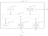
- Fig. 7 shows a block diagram of a computer system for implementing some embodiments of the present disclosure.
- the computer system 70 can be represented in the form of a general-purpose computing device.
- the computer system 70 comprises a memory 710, a processor 720 and a bus 700 connecting different system components.
- the memory 710 comprises, for example, a system memory, a nonvolatile storage medium, and the like.
- the system memory stores, for example, an operating system, an application program, a Boot Loader program and other programs.
- the system memory may comprise volatile storage media such as a random access memory (RAM) and/or a cache memory.
- the nonvolatile storage medium stores, for example, an instruction for implementing an embodiment corresponding to at least one of the object detection methods.
- a non-volatile storage medium includes, but is not limited to, a disk storage, an optical storage, a flash memory, or the like.
- the processor 720 can be realized in the form of a general processor, a digital signal processor (DSP), an application specific integrated circuit (ASIC), a field programmable gate array (FPGA) or any other programmable logic device, a discrete hardware component such as discrete gate or transistor. Accordingly, each module, such as the judging module and the determining module, can be realized by a central processing unit (CPU) running an instruction to execute corresponding steps in a memory, or by a dedicated circuit to execute corresponding steps.
- CPU central processing unit
- the bus 700 may use any of a variety of bus structures.
- the bus structure includes, but is not limited to, an Industry Standard Architecture (ISA) bus, a Microchannel Architecture (MCA) bus and a Peripheral Component Interconnection (PCI) bus.
- ISA Industry Standard Architecture
- MCA Microchannel Architecture
- PCI Peripheral Component Interconnection
- the computer system 70 may further comprise an input/output interface 730, a network interface 740, a storage interface 750, and the like. These interfaces 730, 740, 750 and the memory 710 and the processor 720 can be connected through the bus 700.
- the input/output interface 730 can provide a connection interface for an input/output device such as a display, a mouse and a keyboard.
- the network interface 740 provides a connection interface for various networked devices.
- the storage interface 750 provides a connection interface for an external storage device such as a floppy disk, a USB flash drive or an SD card.
- These computer-readable program instructions may be provided to a processor of a general-purpose computer, special-purpose computer or other programmable apparatus to produce a machine, such that the instructions, when executed through the processor, produce a device which implements functions specified in the flowchart and/or block diagram block or blocks.
- These computer-readable program instructions may also be stored in a computer-readable memory that cause a computer to function in a particular manner to produce an article of manufacture, including instructions that implement the functions specified in the flowchart and/or block diagram block or blocks.
- the present disclosure may take the form of an entirely hardware embodiment, an entirely software embodiment or an embodiment combining software and hardware aspects.
Landscapes
- Engineering & Computer Science (AREA)
- Theoretical Computer Science (AREA)
- General Physics & Mathematics (AREA)
- Physics & Mathematics (AREA)
- Multimedia (AREA)
- Computer Vision & Pattern Recognition (AREA)
- Evolutionary Computation (AREA)
- Artificial Intelligence (AREA)
- Databases & Information Systems (AREA)
- Software Systems (AREA)
- Medical Informatics (AREA)
- General Health & Medical Sciences (AREA)
- Computing Systems (AREA)
- Health & Medical Sciences (AREA)
- Computational Linguistics (AREA)
- Data Mining & Analysis (AREA)
- Life Sciences & Earth Sciences (AREA)
- Bioinformatics & Cheminformatics (AREA)
- Bioinformatics & Computational Biology (AREA)
- Evolutionary Biology (AREA)
- General Engineering & Computer Science (AREA)
- Image Analysis (AREA)
Applications Claiming Priority (2)
| Application Number | Priority Date | Filing Date | Title |
|---|---|---|---|
| CN202210339110.5A CN114648758B (zh) | 2022-04-01 | 2022-04-01 | 物体检测方法及装置、计算机可读存储介质及无人车 |
| PCT/CN2022/136555 WO2023185069A1 (zh) | 2022-04-01 | 2022-12-05 | 物体检测方法及装置、计算机可读存储介质及无人车 |
Publications (2)
| Publication Number | Publication Date |
|---|---|
| EP4465259A1 true EP4465259A1 (de) | 2024-11-20 |
| EP4465259A4 EP4465259A4 (de) | 2025-12-17 |
Family
ID=81994705
Family Applications (1)
| Application Number | Title | Priority Date | Filing Date |
|---|---|---|---|
| EP22934887.5A Pending EP4465259A4 (de) | 2022-04-01 | 2022-12-05 | Objekterkennungsverfahren und -vorrichtung sowie computerlesbares speichermedium und unbemanntes fahrzeug |
Country Status (5)
| Country | Link |
|---|---|
| US (1) | US20250157236A1 (de) |
| EP (1) | EP4465259A4 (de) |
| JP (1) | JP2025511215A (de) |
| CN (1) | CN114648758B (de) |
| WO (1) | WO2023185069A1 (de) |
Families Citing this family (16)
| Publication number | Priority date | Publication date | Assignee | Title |
|---|---|---|---|---|
| CN114842456A (zh) * | 2022-06-29 | 2022-08-02 | 北京科技大学 | 一种基于无人快递车的物流配送方法 |
| CN115661014A (zh) * | 2022-11-07 | 2023-01-31 | 智道网联科技(北京)有限公司 | 一种点云数据处理方法、装置和电子设备、存储介质 |
| CN116243324B (zh) * | 2022-12-02 | 2025-01-07 | 深圳市普渡科技有限公司 | 定位方法、装置、机器人以及存储介质 |
| CN116030270A (zh) * | 2023-02-08 | 2023-04-28 | 北京爱芯科技有限公司 | 目标检测方法、系统、电子设备及计算机可读存储介质 |
| CN116152622B (zh) * | 2023-03-07 | 2026-01-02 | 中国人民解放军国防科技大学 | 基于多尺度特征融合的点云目标检测方法、装置和设备 |
| CN116416223B (zh) * | 2023-03-20 | 2024-01-09 | 北京国信会视科技有限公司 | 一种复杂装备调试方法、系统、电子设备及存储介质 |
| CN116721418B (zh) * | 2023-06-20 | 2026-01-20 | 驭势(上海)汽车科技有限公司 | 标注车辆3d检测框的方法、装置、设备和介质 |
| CN116994105B (zh) * | 2023-07-25 | 2025-08-19 | 深蓝汽车科技有限公司 | 点云-图像双向融合方法、装置、车辆及存储介质 |
| CN116778262B (zh) * | 2023-08-21 | 2023-11-10 | 江苏源驶科技有限公司 | 一种基于虚拟点云的三维目标检测方法和系统 |
| CN117746134A (zh) * | 2023-12-20 | 2024-03-22 | 北京百度网讯科技有限公司 | 检测框的标签生成方法、装置、设备以及存储介质 |
| CN117475110B (zh) * | 2023-12-27 | 2024-04-05 | 北京市农林科学院信息技术研究中心 | 叶片的语义三维重建方法、装置、电子设备及存储介质 |
| CN117740186B (zh) * | 2024-02-21 | 2024-05-10 | 微牌科技(浙江)有限公司 | 隧道设备温度检测方法、装置和计算机设备 |
| CN118657932B (zh) * | 2024-08-15 | 2024-12-13 | 新石器慧通(北京)科技有限公司 | 基于数据合成的目标检测方法、装置、电子设备及介质 |
| CN119311002B (zh) * | 2024-10-12 | 2025-09-23 | 深圳市优必选科技股份有限公司 | 移动机器人避障方法、装置、计算机设备及可读存储介质 |
| CN118968473B (zh) * | 2024-10-21 | 2024-12-31 | 福建省三明高速公路有限公司 | 一种基于视觉信息和点云信息的车辆检测方法 |
| CN121564718A (zh) * | 2026-01-20 | 2026-02-24 | 质子汽车科技有限公司 | 基于动态图谱推理的场景标签生成方法及设备 |
Family Cites Families (6)
| Publication number | Priority date | Publication date | Assignee | Title |
|---|---|---|---|---|
| CN109597087B (zh) * | 2018-11-15 | 2022-07-01 | 天津大学 | 一种基于点云数据的3d目标检测方法 |
| CN110032962B (zh) * | 2019-04-03 | 2022-07-08 | 腾讯科技(深圳)有限公司 | 一种物体检测方法、装置、网络设备和存储介质 |
| CN111209840B (zh) * | 2019-12-31 | 2022-02-18 | 浙江大学 | 一种基于多传感器数据融合的3d目标检测方法 |
| CN112101092B (zh) * | 2020-07-31 | 2024-11-22 | 北京智行者科技股份有限公司 | 自动驾驶环境感知方法及系统 |
| CN113139602A (zh) * | 2021-04-25 | 2021-07-20 | 南京航空航天大学 | 基于单目相机和激光雷达融合的3d目标检测方法及系统 |
| CN113781653B (zh) * | 2021-08-17 | 2022-09-23 | 北京百度网讯科技有限公司 | 对象模型生成方法、装置、电子设备及存储介质 |
-
2022
- 2022-04-01 CN CN202210339110.5A patent/CN114648758B/zh active Active
- 2022-12-05 WO PCT/CN2022/136555 patent/WO2023185069A1/zh not_active Ceased
- 2022-12-05 EP EP22934887.5A patent/EP4465259A4/de active Pending
- 2022-12-05 JP JP2024558074A patent/JP2025511215A/ja active Pending
- 2022-12-05 US US18/839,348 patent/US20250157236A1/en active Pending
Also Published As
| Publication number | Publication date |
|---|---|
| EP4465259A4 (de) | 2025-12-17 |
| JP2025511215A (ja) | 2025-04-15 |
| WO2023185069A1 (zh) | 2023-10-05 |
| CN114648758B (zh) | 2025-10-28 |
| CN114648758A (zh) | 2022-06-21 |
| US20250157236A1 (en) | 2025-05-15 |
Similar Documents
| Publication | Publication Date | Title |
|---|---|---|
| EP4465259A1 (de) | Objekterkennungsverfahren und -vorrichtung sowie computerlesbares speichermedium und unbemanntes fahrzeug | |
| CN114708585B (zh) | 一种基于注意力机制的毫米波雷达与视觉融合的三维目标检测方法 | |
| Königshof et al. | Realtime 3d object detection for automated driving using stereo vision and semantic information | |
| CN111160302B (zh) | 基于自动驾驶环境的障碍物信息识别方法和装置 | |
| Simonelli et al. | Disentangling monocular 3d object detection: From single to multi-class recognition | |
| US12046055B2 (en) | Associating two dimensional label data with three-dimensional point cloud data | |
| EP3620964B1 (de) | Fahrspurlinienverarbeitungsverfahren und -vorrichtung | |
| US20220319146A1 (en) | Object detection method, object detection device, terminal device, and medium | |
| US11288828B2 (en) | Object recognition system based on machine learning and method thereof | |
| Bruls et al. | The right (angled) perspective: Improving the understanding of road scenes using boosted inverse perspective mapping | |
| Srivastava et al. | Learning 2d to 3d lifting for object detection in 3d for autonomous vehicles | |
| CN115410167A (zh) | 目标检测与语义分割方法、装置、设备及存储介质 | |
| EP3832531B1 (de) | Fahrzeuge, systeme und verfahren zur bestimmung eines eintritts einer belegungskarte in der nähe eines fahrzeugs | |
| CN114155414B (zh) | 面向无人驾驶的新型特征层数据融合的方法、系统及目标检测方法 | |
| US12293593B2 (en) | Object detection method, object detection device, terminal device, and medium | |
| CN114761997A (zh) | 目标检测方法、终端设备和介质 | |
| CN114708583B (zh) | 目标物的检测方法、装置、设备及存储介质 | |
| KR20240144251A (ko) | 준의사 라벨들을 사용하는 신경망 트레이닝 방법 | |
| CN114648639B (zh) | 一种目标车辆的检测方法、系统及装置 | |
| CN116778262B (zh) | 一种基于虚拟点云的三维目标检测方法和系统 | |
| US11657506B2 (en) | Systems and methods for autonomous robot navigation | |
| CN116386003A (zh) | 基于知识蒸馏的三维目标检测方法 | |
| CN119323776A (zh) | 一种基于点云与图像的3d障碍物细分属性预标注方法 | |
| EP4473476B1 (de) | Sichtbasiertes wahrnehmungssystem | |
| CN117789163A (zh) | Bev视觉三维目标检测方法及终端 |
Legal Events
| Date | Code | Title | Description |
|---|---|---|---|
| STAA | Information on the status of an ep patent application or granted ep patent |
Free format text: STATUS: THE INTERNATIONAL PUBLICATION HAS BEEN MADE |
|
| PUAI | Public reference made under article 153(3) epc to a published international application that has entered the european phase |
Free format text: ORIGINAL CODE: 0009012 |
|
| STAA | Information on the status of an ep patent application or granted ep patent |
Free format text: STATUS: REQUEST FOR EXAMINATION WAS MADE |
|
| 17P | Request for examination filed |
Effective date: 20240816 |
|
| AK | Designated contracting states |
Kind code of ref document: A1 Designated state(s): AL AT BE BG CH CY CZ DE DK EE ES FI FR GB GR HR HU IE IS IT LI LT LU LV MC ME MK MT NL NO PL PT RO RS SE SI SK SM TR |
|
| DAV | Request for validation of the european patent (deleted) | ||
| DAX | Request for extension of the european patent (deleted) | ||
| A4 | Supplementary search report drawn up and despatched |
Effective date: 20251114 |
|
| RIC1 | Information provided on ipc code assigned before grant |
Ipc: G06V 20/64 20220101AFI20251110BHEP Ipc: G06V 20/70 20220101ALI20251110BHEP Ipc: G06V 10/80 20220101ALI20251110BHEP Ipc: G06V 20/58 20220101ALI20251110BHEP Ipc: G06V 10/82 20220101ALI20251110BHEP Ipc: G06V 10/25 20220101ALI20251110BHEP Ipc: G06V 10/764 20220101ALI20251110BHEP |