EP4451014A1 - Verbesserte gnss-positionierung - Google Patents
Verbesserte gnss-positionierung Download PDFInfo
- Publication number
- EP4451014A1 EP4451014A1 EP23169058.7A EP23169058A EP4451014A1 EP 4451014 A1 EP4451014 A1 EP 4451014A1 EP 23169058 A EP23169058 A EP 23169058A EP 4451014 A1 EP4451014 A1 EP 4451014A1
- Authority
- EP
- European Patent Office
- Prior art keywords
- signals
- signal
- determining
- residual
- threshold
- Prior art date
- Legal status (The legal status is an assumption and is not a legal conclusion. Google has not performed a legal analysis and makes no representation as to the accuracy of the status listed.)
- Pending
Links
Images


Classifications
-
- G—PHYSICS
- G01—MEASURING; TESTING
- G01S—RADIO DIRECTION-FINDING; RADIO NAVIGATION; DETERMINING DISTANCE OR VELOCITY BY USE OF RADIO WAVES; LOCATING OR PRESENCE-DETECTING BY USE OF THE REFLECTION OR RERADIATION OF RADIO WAVES; ANALOGOUS ARRANGEMENTS USING OTHER WAVES
- G01S19/00—Satellite radio beacon positioning systems; Determining position, velocity or attitude using signals transmitted by such systems
- G01S19/01—Satellite radio beacon positioning systems transmitting time-stamped messages, e.g. GPS [Global Positioning System], GLONASS [Global Orbiting Navigation Satellite System] or GALILEO
- G01S19/13—Receivers
- G01S19/22—Multipath-related issues
-
- G—PHYSICS
- G01—MEASURING; TESTING
- G01S—RADIO DIRECTION-FINDING; RADIO NAVIGATION; DETERMINING DISTANCE OR VELOCITY BY USE OF RADIO WAVES; LOCATING OR PRESENCE-DETECTING BY USE OF THE REFLECTION OR RERADIATION OF RADIO WAVES; ANALOGOUS ARRANGEMENTS USING OTHER WAVES
- G01S19/00—Satellite radio beacon positioning systems; Determining position, velocity or attitude using signals transmitted by such systems
- G01S19/01—Satellite radio beacon positioning systems transmitting time-stamped messages, e.g. GPS [Global Positioning System], GLONASS [Global Orbiting Navigation Satellite System] or GALILEO
- G01S19/13—Receivers
- G01S19/32—Multimode operation in a single same satellite system, e.g. GPS L1/L2
Definitions
- the present invention relates to the field of global navigation satellite systems (GNSS). More particularly, the present invention relates to the field of mitigating multipath interference in GNSS.
- GNSS global navigation satellite systems
- GNSS is a satellite navigation system which utilizes signals transmitted from one or more constellations of satellites orbiting the earth.
- GNSS receivers are configured to receive the satellite signals and process them to determine a navigation solution.
- Such a navigation solution generally includes the position and velocity of the receiver as well as precise time. This can be referred to as Position, Velocity and Time or PVT.
- GNSS has proven to be highly accurate. However, because GNSS signals are electromagnetic, they can be blocked by objects such as mountains, tall buildings, and dense foliage.
- Multipath is a major error source for GNSS receivers and can occur in situations where the direct GNSS signal is blocked and only a reflected satellite signal is received by the antenna of a GNSS receiver.
- multipath effects can also occur when GNSS signals transmitted by a particular satellite travel by two or more paths to the GNSS receiver's antenna.
- the GNSS receiver intercepts a direct or line-of-sight (LOS) component together with one or more non-line-of-sight (NLOS) components.
- LOS line-of-sight
- NLOS non-line-of-sight
- the signals travelling different paths can experience fading and phase shifting which can cause measurement errors and/or compromise the correlation function shape used to estimate the time delay when processing the GNSS signals.
- the GNSS signals can be subjected to a significant amount of multipath interference which can result in significant GNSS measurement errors.
- a typical approach for mitigating multipath interference in GNSS involves detection and correction of individual affected navigation measurements. Typically, this is done during a signal processing stage. Such an approach may not always perform well. For example, heavy multipath interference tends to distort measurements in ways that are difficult to model reliably. Therefore, if the signals are severely degraded or if assumptions about properties of the degraded signals, such as uniformity of phase error, are not accurate, detection and correction of individual measurements may not yield accurate results.
- GNSS signals There are a plurality of different GNSS signals, each with different characteristics based on, inter alia, their chipping rate and their spread spectrum. Due to the differing characteristics, some signals are more resilient to multipath interference because it is easier to distinguish between different portions of the signal.
- some signals may be more resilient to multipath interference: if there is a large difference between data from these signals and data from those signals known (due to their characteristics) to be less resilient to multipath interference it may indicate that multipath interference is occurring. In these situations one or more of the signals less resilient to multipath interference may be excluded from the calculation of the position.
- the method uses data from a previous epoch (or time period) to predict the position during the current epoch.
- the range from the predicted position is compared to the pseudo-range based on an individual signal from a space vehicle: this is known as the residual. If a signal is affected by multipath interference there may be a greater discrepancy between the predicted position (or range based on the predicted position) and the measured position (or pseudo-range) than there would be if the signal is not affected by multipath.
- L5 signals are known to be resilient to multipath interference due to their faster chipping rate.
- L1 and L2 signals are more susceptible to multipath interference because of their slower chipping rates.
- a method of mitigating multipath interference in a global navigation satellite system, GNSS, receiver comprising:
- the present invention therefore provides a method to identify the likelihood of a location being affected by multipath interference. If it is determined that a location is likely to be affected by multipath interference then a position can be determined based on signals known to be less affected by multipath interference. Thus, the position determination may be made using only a subset of signals, excluding at least one L1 and/or L2 signal. In this way, the effects of multipath interference are mitigated and improved GNSS positioning is achieved.
- statistic refers to mathematically generated result/s, e.g. distribution/s, wherein said result/s may be presented as absolute or discrete value/s or value/s relative to the predetermined limit or threshold (or to another one).
- the result/s may also be dependent on other variables, which are not part of the comparison between the previously mentioned residuals and/or which are variables of said residuals.
- L1 and/or L2 signals from space vehicles from which there is also an L5 signal are excluded from the subset used to determine position.
- L5 signals from these space vehicles will already be used in the position determination so the exclusion of the corresponding L1 and/or L2 signal does not reduce the number of space vehicles used in the position determination.
- L1 and/or L2 signals from space vehicles from which there is also a L5 signal are excluded from the subset if the difference between the L1 and/or L2 signal residual and the L5 residual is greater than a predetermined individual distance threshold.
- space vehicles which only transmit L1 and/or L2 signals, known to be less resilient to multipath interference, and no L5 signal.
- these signals may be excluded from the subset used to determine the position.
- L1 and/or L2 signals from space vehicles without an L5 signal are excluded from the subset when their residual is above a predetermined individual residual threshold.
- the other signals, for which there is not a large discrepancy may be used.
- the more space vehicles that are used in the position determination the greater the resulting accuracy.
- the method may further comprise determining an elevation angle for L1 and/or L2 signals from space vehicles without an L5 signal are excluded from the subset if the angle of elevation of the corresponding space vehicle is below a predetermined elevation threshold.
- Lower angles of elevation are more likely to be affected by multipath interference so this provides a way to identify which L1 and/or L2 signals (for which there is no corresponding L5 signal) are more likely to be affected by multipath interference.
- Determining the statistic may comprise:
- the position is deemed to be a position affected by multipath interference. Mitigation, by determining the position based only on a subset of signals can then occur.
- the statistic may be based on an aggregate across all the signals of a particular type.
- determining the statistic may comprise:
- the statistic may not be a direct comparison between residuals and may comprise other data.
- An example of this is the use of the standard deviation of the residuals.
- determining the statistic may comprise:
- the method described above may be used if the number of space vehicles exceeds a predetermined threshold. If the number of space vehicles is less than a predetermined threshold then there may be insufficient space vehicles for the method described above to be statistically significant.
- a method of determining an overall position comprising:
- the overall position is determined as described above; and if the number of space vehicles is below a predetermined space vehicle number threshold determining the overall position based on an estimated position from all the signals.
- a method of determining an overall position comprises:
- the overall position is determined based on the estimated position from all the signals; and if the average of all residuals is below a maximum average residual value the overall position is determined according to any one of the preceding claims.
- GNSS receiver comprising:
- the static GNSS receiver may further comprise an RF front-end.
- the RF front-end may be configured to receive GNSS signals via an antenna.
- the signal processing unit may be configured to make GNSS measurements (pseudorange measurements, and optionally carrier range measurements) on the GNSS signals received by the RF front-end.
- the processor of the GNSS receiver is further configured to perform the steps of the previously mentioned methods of the invention.
- a base station for a communications network comprising the GNSS receiver as described above.
- a computer program comprising computer program code configured to cause one or more processors to perform all the steps of the method as described above when said computer program is executed on said one or more processors.
- the one or more processors may comprise or consist of one or more processors of a GNSS receiver.
- the computer program may be stored on a computer-readable storage medium (optionally non-transitory).
- the present invention provides a method of mitigating multipath interference in a global navigation satellite system (GNSS).
- GNSS global navigation satellite system
- a GNSS receiver can be configured to perform a method of mitigating multipath interference in accordance with an embodiment of the present invention.
- the present invention also provides a GNSS receiver which is configured to mitigate multipath interference in a global navigation satellite system (GNSS).
- GNSS global navigation satellite system
- GNSS Global Positioning System
- GLONASS Global Navigation Satellite System
- BDS BeiDou Navigation Satellite System
- Galileo European Union's Galileo
- the GNSS satellites of these various systems typically transmit GNSS signals in more than one frequency band.
- the frequency bands which are currently available under GPS include the L1, L2 and L5 bands.
- the signal carrier frequency is generally in the range of 1.559 GHz to 1.610 GHz.
- the signal carrier frequency is generally in the range of 1.18845 GHz to 1.258 GHz.
- the signal carrier frequency is generally in the range of 1.164 GHz to 1.189 GHz. Additional or different frequency bands may become available in the future for GPS.
- L1 has a chipping rate of 1.023MHz
- L2 has a chipping rate of 511.5kHz
- L5 has a faster chipping rate of 10.23MHz.
- the peak of the correlation functions become narrower than those of L1 and L2.
- a correlation peak of L1 corresponds to 293m
- a correlation peak of L5 corresponds to 29.3m. Due to the narrower correlation functions, it is easier to distinguish between L5 signals transmitted by different paths (for example due to reflections in a multipath environment) than it is to distinguish between L1 or L2 signals transmitted by different paths. Thus, L5 signals are more resistant in multipath environments than L1 signals.
- a GNSS receiver may operate in a single-band mode in which it performs signal processing to determine navigation measurements on signals in only one band, for example, the L1 band only or, as another example, the L5 band only.
- the GNSS receiver may operate in a dual- or multi-band mode in which it performs signal processing using signals in multiple bands within a particular constellation, for example, L1 and L5 dual-band mode in GPS.
- a GNSS receiver may be configured to operate in a multi-band mode in which three or more signal bands are utilized (e.g., L1, L2 and L5). It is generally expected that multi-band processing will achieve more accurate navigation measurements than single-band processing.
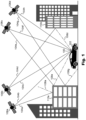
- FIG. 1 illustrates a global navigation satellite system in accordance with an embodiment of the present invention.
- a GNSS receiver 100 located in a vehicle 102 moving within a multipath environment is shown.
- GNSS satellite signals 104a-h are transmitted from a plurality of satellites 106a-d.
- some signals from the transmitted satellite signals 104a-h may comprise LOS signals 104b, 104c, 104f and 104h because they travel to the GNSS receiver 100 via a direct path.
- Other signals from the transmitted satellite signals 104a-h however may comprise non-LOS signals 104a, 104d, 104e and 104g because they are reflected by obstacles within the environment.
- the obstacles comprise buildings 110a and 110b.
- the building 110a reflects GNSS satellite signals 104a, 104e and 104g resulting in reflected satellite signals 108a, 108e and 108g, respectively.
- GNSS satellite signal 104d on the other hand is reflected by building 110b, resulting in reflected satellite signal 108d. Some of the reflected satellite signals may be reflected in the direction of the vehicle 102 and thus reach the GNSS receiver 100. Others on the other hand may be reflected in a different direction. In the present example, reflected GNSS satellite signals 108d and 108e are intercepted by the GNSS receiver 100 whereas reflected satellite signals 108a and 108g are reflected in different direction and are therefore not intercepted by the GNSS receiver 100.
- GPS presently consists of at least 24 active and 3-5 spare satellites in the earth's orbit, while four satellites are generally required to uniquely determine the position of the receiver 100 in three dimensions. Reception of GNSS signals from greater than four satellites can improve position accuracy.
- the satellites 106a-d are each configured to transmit GNSS signals 104a-h in two or more frequency bands.
- the two or more frequency bands can be selected from among the currently available bands.
- GNSS receiver 100 may be configured to receive satellite signals in any two bands chosen from the L1, L2 and L5 frequency bands.
- GNSS receiver 100 may be configured to receive all three frequency bands L1, L2 and L5 of GPS.
- the satellites 106a-d can be configured to transmit GNSS signals 104a-h in any or all such frequency bands and the receiver 100 can be configured to receive and process GNSS signals 104a-h in any or all such bands. Accordingly, changes to the available signal frequency bands are presently contemplated as being within the scope of the present invention.
- the receiver 100 is configured to receive the navigation satellite signals from the satellites 106a-d and to process those signals to determine a navigation solution from the received signals.
- the receiver 100 receives and processes GNSS signals 104b, 104c, 104d/108d, 104e/108e, 104f and 104h. This includes operation in single-band mode, dual-band mode or multi-band mode with respect to at least the frequency bands L1, L2 and L5 and possibly other frequency bands.
- FIG. 2 illustrates a block schematic diagram of a GNSS receiver 200 for mitigating multipath interference in a global navigation satellite system in accordance with an embodiment of the present invention.
- the receiver 200 can be identical to the GNSS receiver 100 of Figure 1 .
- the GNSS receiver 200 is configured to receive GNSS satellite signals from GNSS satellites via an antenna 201.
- the received signals are passed from the antenna 201 to RF front-end 202 which performs tasks such as amplification, down-conversion, filtering and digitization of the captured satellite signals.
- the RF front-end 202 may include further functionality such as frequency synthesis (not shown).
- the receiver 200 is further configured to process the received signals using a processor 204 to extract observables and navigation data from each channel of the baseband processing unit and to generate a navigation solution 206.
- the processor 204 may include an internal or external memory 205 for storing and/or retrieving data associated with the processing.
- the navigation solution 206 generated by the receiver 200 may include the calculated position and velocity of the receiver 200 as well as a determination of precise GNSS time.
- the navigation solution may be derived from any one, or multiple ones of, the GNSS frequency band signals received at the antenna 201, which may include GNSS signals from different GNSS constellations.
- the navigation solution may also take into account discounting of any one or more of the GNSS frequency band signals received at the antenna 201.
- the receiver 200 receives satellite signals from one or more GNSS constellations and the processor 204 processes these signals to provide GNSS measurements such as pseudo-ranges, carrier phases, rates of pseudo-ranges, etc. to a navigation filter.
- the processor 204 may, for example, implement the filter, e.g. a Kalman filter or a least-squares (LSQ) filter, which is used to determine the navigation solution 206 based on the GNSS measurements.
- LSQ least-squares
- the processor 204 may also determine whether multipath interference is likely to be present.
- FIG. 3 illustrates a flow diagram of a method in accordance with an embodiment of the present invention.
- a first step 301 GNSS signals are received from a plurality of space vehicles.
- a plurality of the space vehicles from which signals are received emit at least an L5 signal and an L1 and/or L2 band signal.
- a pseudo-range is determined for each signal for the current epoch (time period).
- a GPS receiver compares the time a signal was transmitted by a satellite with the time it was received by the GPS receiver. The time difference tells the GPS receiver how far away that particular satellite is i.e. the pseudo-range.
- a position is determined based on a combination of pseudo-ranges from a plurality of satellites.
- the previous epoch time period
- an estimated measurement to the space vehicle in the current epoch can be made.
- the estimate includes an estimate of the current position based on the position and velocity in a previous epoch but may also include corrections due to the transmission.
- the difference between the estimated measurement to the space vehicle and the pseudo-range of the corresponding space vehicle can be determined.
- a comparison can be made between the residuals of the L1 and/or L2 signals and the residuals of the L5 signals.
- the L5 signals are more resilient to multipath interference so a difference between the residuals of the L5 signals and the L1 and/or L2 signals may indicate multipath interference.
- a statistic is determined based on a comparison between residuals of the L5 signals and residuals of the L1 and/or L2 signals. This statistic may be the difference in average residuals between the L5 signals and the L1 and/or L2 signals. Alternatively it could be a ratio of the L1 and/or L2 signals to a corresponding L5 signal.
- Some space vehicles transmit both an L5 signal and an L1 and/or L2 signal. However, other space vehicles transmit only L1 and/or L2 signals. These signals may or may not be included within the subset.
- the advantage of including signals from space vehicles not transmitting an L5 signal in the subset is that such a position may be more accurate as it includes information from more space vehicles.
- the disadvantage of including signals from space vehicles not transmitting an L5 signals in the subset is that the subset may include data heavily affected by multipath interference.
- L1 and/or L2 signals from space vehicles without an L5 signal are excluded from the subset.
- L1 and/or L2 signals from space signals without an L5 signal are excluded from the subset if their residual is above a predetermined individual threshold.
- the dilution of precision may be determined based on signals from the space vehicles transmitting a L5 signal and if the dilution of precision is below a threshold then L1 and/or L2 signals from space vehicles not transmitting a L5 signal can be excluded from the subset.
- the elevation angle of space vehicles transmitting only an L1 and/or L2 signal is determined. If the angle of elevation of the corresponding space vehicle is below a predetermine elevation threshold then the L1 and/or L2 signal is excluded from the subset.
- the statistic may relate to a combination of L5 signals and a combination of L1 and/or L2 signals or alternatively may compare specific L5 signals with specific L1 and/or L2 signals.
- the statistic may relate to a combination of L5 signals and a combination of L1 and/or L2 signals or alternatively may compare specific L5 signals with specific L1 and/or L2 signals.
- the elevation angle of individual space vehicles signals from different space vehicles may be affected by multipath interference to a greater or lesser extent.
- An example of a comparison between individual signal is a comparison between a residual of a L5 signal from a specific space vehicle and a residual of a L1 and/or L2 signal from the same specific space vehicle to determine a difference between the two residuals.
- the determination step 306 then comprises determining whether the difference in residuals is greater than a predetermined difference threshold. The percentage of space vehicles for which the ratio is over the predetermined difference threshold is then determined. If the percentage is greater than a predetermined percentage threshold then the environment is deemed to be affected by multipath interference and the position is determined based on a subset of signals comprising the L5 signals excluding at least one of the L1 and/or L2 signals. A further statistic, based on signals from individual space vehicles may be determined and individual L1 and/or L2 signals excluded on the basis of the statistic based on signals from the respective space vehicle.
- a further example of comparison between individual signals is a comparison between a residual of a L5 signal from a specific space vehicle and a residual of a L1 and/or L2 signal from the same specific space vehicle to determine a ratio of the two residuals.
- the determination step 306 then comprises determining whether the difference is greater than a predetermined ratio threshold. The percentage of space vehicles for which the ratio is over the predetermined ratio threshold is then determined. If the percentage is greater than a predetermined percentage threshold then the environment is deemed to be affected by multipath interference and the position is determined based on a subset of signals comprising the L5 signals excluding at least one of the L1 and/or L2 signals.
- a further statistic, based on signals from individual space vehicles may be determined and individual L1 and/or L2 signals excluded on the basis of the statistic based on signals from the respective space vehicle.
- the statistic may relate to the group properties of the L5 signals as a whole compared the group properties of the L1 and/or L2 signals as a whole (from satellite vehicles transmitting both a L5 signal and a L1 and/or L2 signal).
- an average residual for all the L5 signals is determined and an average residual for all the L1 and/or L2 signals determined.
- the difference between the residual for the L5 signals and the residual from the L1 and/or L2 signals is compared and if it is greater than a predetermined average distance threshold the environment is considered affected by multipath interference and the position is calculated based on a subset excluding at least on L1 and/or L2 signal.
- the statistic can be any statistic which compares the residuals of one or more L5 signals with one or more L1 and/or L2 signals.
- An example of an alternative statistic is the standard deviation of all the residuals.
- the standard deviation of all the results is determined.
- the standard deviation indicates the spread of results so a large spread may indicate a large amount of variation in the residuals and therefore a multipath environment.
- the standard deviation is compared to a predetermined standard deviation threshold to determine whether it is a multipath environment.
- the statistic to be determined may be based on or is a combination of one or more of the same and/or different statistics previously mentioned.
- a multipath environment may be detected using a statistic based on signals from a plurality of signals. Then, if a multipath environment is detected a further statistic evaluated (using the methods above) based on signals from a single space vehicle and individual L1 and/or L2 signals excluded based on the statistic from the single space vehicle.
- This method may only be applicable if the number of space vehicles transmitting an L5 and an L1 and/or L2 signal is sufficiently significant. Therefore a test may be performed in which the number of space vehicles transmitting a L5 and a L1 and/or L2 signal is determined.
- the method of mitigating a multipath environment described above is only carried out if the number of space vehicles transmitting a L5 and a L1 and/or L2 signal is above a predetermined threshold. If it is not above a predetermined threshold then a conventional position determination (without the multipath mitigation method described above) is carried out.
- the dilution of precision refers to the dilution in precision of the determined position if one or more signals are removed from the position determination. If the dilution of precision is large then the method described herein may not be suitable because the loss of precision would be too significant. Thus, the dilution of precision of the space vehicles may be determined. If (and only if) the dilution of precision is below a predetermined dilution of precision threshold the method described above is carried. If the dilution of precision is not below the predetermined dilution of precision threshold then the position is determined using all the available signals.
- the average of all residuals may be determined. If the average of all the residuals is below a maximum average residual value the method may be carried out. However, if the average of all the residuals is not below a maximum average residual the position may be determined using all the available signals.
- a GNSS receiver comprises a signal processing unit 110 and a processor configured to carry out the steps described above.
- the GNSS receiver may form part of a base station for a communications network
- number of space vehicles refers to the number of space vehicles from which signals are received at the given position at that point in time.
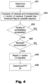
- a further method is depicted in Figure 4 .
- Residuals for each signal are determined using a method as described above, in step 401.
- step 402 the residual of an L5 signal and an L1 and/or L2 signal for the same space vehicle are compared. If the difference between the residuals is greater than a predetermined threshold then the L1 and/or L2 signals are flagged as candidates for rejection.
- step 403 the quality of the constellation as a whole is assessed. This can be by comparing the number of satellites transmitting an L5 and and L1 and/or L2 signal. It can also, or alternatively be by assessing the maximum dilution of precision.
- an assessment about the environment is performed at step 404. This can be by one or both of the following methods:
- L1 and/or L2 signals are rejected. This may be all L1 and/or L2 signals, or only L1 and/or L2 signals from a space vehicle with an L5 signal or only L1 and/or L2 signals with residuals larger than a threshold.
- a PVT (position, velocity, time) fix is determined using signals not excluded in step 405.
- the signals flagged at step 402 can be excluded as these are the signals for which there is a discrepancy between the residuals from the L5 signal and the L1 and/or L2 signal.
- a PVT fix can be determined using the signals except for these.
- any reference signs placed between parentheses shall not be construed as limiting the claim.
- the word “comprising” does not exclude the presence of elements or steps other than those listed in a claim. However, where the word “comprising” is used, this also discloses as a special case the possibility that the elements or steps listed are exhaustive - that is, the apparatus or method may consist solely of those elements or steps.
- the word “a” or “an” preceding an element does not exclude the presence of a plurality of such elements.
- the embodiments may be implemented by means of hardware comprising several distinct elements. In a device claim enumerating several means, several of these means may be embodied by one and the same item of hardware.
- the various embodiments may be implemented in hardware or special purpose circuits, software, logic or any combination thereof.
- some aspects may be implemented in hardware, while other aspects may be implemented in firmware or software, which may be executed by a controller, microprocessor or other computing device, although these are not limiting examples.
- firmware or software which may be executed by a controller, microprocessor or other computing device, although these are not limiting examples.
- various aspects described herein may be illustrated and described as block diagrams, flow charts, or using some other pictorial representation, it is well understood that these blocks, apparatus, systems, techniques or methods described herein may be implemented in, as non-limiting examples, hardware, software, firmware, special purpose circuits or logic, general purpose hardware or controller or other computing devices, or some combination thereof.
- any blocks of the logic flow as in the Figures may represent program steps, or interconnected logic circuits, blocks and functions, or a combination of program steps and logic circuits, blocks and functions.
- the software may be stored on such physical media as memory chips, or memory blocks implemented within the processor, magnetic media such as hard disk or floppy disks, and optical media such as for example DVD and the data variants thereof, or CD.
- the memory may be of any type suitable to the local technical environment and may be implemented using any suitable data storage technology, such as semiconductor-based memory devices, magnetic memory devices and systems, optical memory devices and systems, fixed memory and removable memory.
- the data processors may be of any type suitable to the local technical environment, and may include one or more of general purpose computers, special purpose computers, microprocessors, digital signal processors (DSPs), application specific integrated circuits (ASIC), gate level circuits and processors based on multi-core processor architecture, as non-limiting examples.
- Embodiments as discussed herein may be practiced in various components such as integrated circuit modules.
- the design of integrated circuits is generally a highly automated process. Complex and powerful software tools are available for converting a logic level design into a semiconductor circuit design ready to be etched and formed on a semiconductor substrate.
Landscapes
- Engineering & Computer Science (AREA)
- Radar, Positioning & Navigation (AREA)
- Remote Sensing (AREA)
- Computer Networks & Wireless Communication (AREA)
- Physics & Mathematics (AREA)
- General Physics & Mathematics (AREA)
- Position Fixing By Use Of Radio Waves (AREA)
Priority Applications (3)
| Application Number | Priority Date | Filing Date | Title |
|---|---|---|---|
| EP23169058.7A EP4451014A1 (de) | 2023-04-20 | 2023-04-20 | Verbesserte gnss-positionierung |
| US18/636,924 US20240353572A1 (en) | 2023-04-20 | 2024-04-16 | Gnss positioning |
| CN202410473598.XA CN118818536A (zh) | 2023-04-20 | 2024-04-19 | 改进的gnss定位 |
Applications Claiming Priority (1)
| Application Number | Priority Date | Filing Date | Title |
|---|---|---|---|
| EP23169058.7A EP4451014A1 (de) | 2023-04-20 | 2023-04-20 | Verbesserte gnss-positionierung |
Publications (1)
| Publication Number | Publication Date |
|---|---|
| EP4451014A1 true EP4451014A1 (de) | 2024-10-23 |
Family
ID=86096010
Family Applications (1)
| Application Number | Title | Priority Date | Filing Date |
|---|---|---|---|
| EP23169058.7A Pending EP4451014A1 (de) | 2023-04-20 | 2023-04-20 | Verbesserte gnss-positionierung |
Country Status (3)
| Country | Link |
|---|---|
| US (1) | US20240353572A1 (de) |
| EP (1) | EP4451014A1 (de) |
| CN (1) | CN118818536A (de) |
Citations (2)
| Publication number | Priority date | Publication date | Assignee | Title |
|---|---|---|---|---|
| US8427367B2 (en) * | 2009-01-14 | 2013-04-23 | Trimble Navigation Limited | Selecting raw measurements for use in position computation |
| US20210132236A1 (en) * | 2019-10-30 | 2021-05-06 | Qualcomm Incorporated | Multipath mitigation for multiband gnss receiver |
Family Cites Families (9)
| Publication number | Priority date | Publication date | Assignee | Title |
|---|---|---|---|---|
| US5917445A (en) * | 1996-12-31 | 1999-06-29 | Honeywell Inc. | GPS multipath detection method and system |
| US20050114023A1 (en) * | 2003-11-26 | 2005-05-26 | Williamson Walton R. | Fault-tolerant system, apparatus and method |
| US7095368B1 (en) * | 2005-03-18 | 2006-08-22 | Global Locate, Inc. | Method and apparatus for combining measurements and determining clock offsets between different satellite positioning systems |
| JP2008286753A (ja) * | 2007-05-21 | 2008-11-27 | Panasonic Corp | 測位装置及びその制御方法 |
| US20110080318A1 (en) * | 2009-10-02 | 2011-04-07 | Skyhook Wireless, Inc. | Determining A Dilution of Precision Metric Using Two or Three GPS Satellites |
| DE102015203616A1 (de) * | 2015-02-27 | 2016-09-01 | Continental Teves Ag & Co. Ohg | Multipath Erkennung mittels Vergleich zweier unterschiedlicher GNSS Signalen |
| KR102609093B1 (ko) * | 2018-10-26 | 2023-12-04 | 삼성전자주식회사 | Gnss 신호의 다중 경로 상태를 검출하는 방법 및 이를 지원하는 전자 장치 |
| US11585944B2 (en) * | 2020-11-05 | 2023-02-21 | U-Blox Ag | Method of and receiver for mitigating multipath interference in a global navigation satellite system |
| US12279224B2 (en) * | 2022-10-28 | 2025-04-15 | Qualcomm Incorporated | Radio frequency multipath detection |
-
2023
- 2023-04-20 EP EP23169058.7A patent/EP4451014A1/de active Pending
-
2024
- 2024-04-16 US US18/636,924 patent/US20240353572A1/en active Pending
- 2024-04-19 CN CN202410473598.XA patent/CN118818536A/zh active Pending
Patent Citations (2)
| Publication number | Priority date | Publication date | Assignee | Title |
|---|---|---|---|---|
| US8427367B2 (en) * | 2009-01-14 | 2013-04-23 | Trimble Navigation Limited | Selecting raw measurements for use in position computation |
| US20210132236A1 (en) * | 2019-10-30 | 2021-05-06 | Qualcomm Incorporated | Multipath mitigation for multiband gnss receiver |
Non-Patent Citations (1)
| Title |
|---|
| PIRSIAVASH ALI ET AL: "GNSS Signal and Measurement Quality Monitoring for Multipath Detection and Mitigation", 1 August 2019 (2019-08-01), Calgary, Canada, XP055839978, Retrieved from the Internet <URL:https://prism.ucalgary.ca/bitstream/handle/1880/113363/ReportonGNSSSignalandMeasurementQualityMonitoringforGNSSMultipathDetectionandMitigation_AliPirsiavash_August2019.pdf?sequence=1&isAllowed=y> [retrieved on 20210910] * |
Also Published As
| Publication number | Publication date |
|---|---|
| CN118818536A (zh) | 2024-10-22 |
| US20240353572A1 (en) | 2024-10-24 |
Similar Documents
| Publication | Publication Date | Title |
|---|---|---|
| Closas et al. | Direct position estimation of GNSS receivers: Analyzing main results, architectures, enhancements, and challenges | |
| US11585944B2 (en) | Method of and receiver for mitigating multipath interference in a global navigation satellite system | |
| EP3030922B1 (de) | Nachweis von szintillationen in signalen globaler navigationssatellitensysteme durch ionosphären-unregelmässigkeiten | |
| US8395543B2 (en) | Method and apparatus for mitigating multipath effects at a satellite signal receiver using a sequential estimation filter | |
| EP2652523B1 (de) | Verfahren und system zur lokalisierung von mobilen kommunikationsendgeräten | |
| US9244174B2 (en) | Mitigation of scintillations in signals of global navigation satellite systems caused by ionospheric irregularities | |
| CN112313542B (zh) | 定位方法及定位终端 | |
| CN109975837A (zh) | 在星基定位测量系统中检查移动载波位置的估计完整性的方法 | |
| US7633436B2 (en) | Satellite-based positioning of mobile terminals | |
| WO2021091414A1 (en) | Method and apparatus for detecting gnss spoofing | |
| US5917445A (en) | GPS multipath detection method and system | |
| Beitler et al. | CMCD: multipath detection for mobile GNSS receivers | |
| Massarweh et al. | Assessment of real-time multipath detection with Android raw GNSS measurements by using a xiaomi mi 8 smartphone | |
| US11209552B2 (en) | Method and apparatus for improving the quality of position determination using GNSS data | |
| Farooq et al. | Survey of cycle slip detection & correction techniques for single frequency receivers | |
| CN115586551A (zh) | 异常伪距识别方法、装置及计算机可读介质 | |
| CN118482630B (zh) | 一种伪卫星辅助dbd的变形监测方法 | |
| US20240353572A1 (en) | Gnss positioning | |
| US8416131B2 (en) | Cinematic parameter computing method of a satellite navigation system and receiving apparatus employing the method | |
| US12061270B2 (en) | Method and apparatus for detecting GNSS spoofing | |
| CN112415547A (zh) | 卫星信号的周跳计算方法及装置 | |
| EP4538748A1 (de) | Einstellung von signalerkennungsschwellen | |
| EP4517385A1 (de) | Überprüfung eines navigationsfix | |
| Pasnikowski et al. | Challenges for integrity in navigation of high precision | |
| EP4692856A1 (de) | Verfahren und systeme zur positionsbestimmung unter berücksichtigung von mehrweg |
Legal Events
| Date | Code | Title | Description |
|---|---|---|---|
| PUAI | Public reference made under article 153(3) epc to a published international application that has entered the european phase |
Free format text: ORIGINAL CODE: 0009012 |
|
| STAA | Information on the status of an ep patent application or granted ep patent |
Free format text: STATUS: THE APPLICATION HAS BEEN PUBLISHED |
|
| AK | Designated contracting states |
Kind code of ref document: A1 Designated state(s): AL AT BE BG CH CY CZ DE DK EE ES FI FR GB GR HR HU IE IS IT LI LT LU LV MC ME MK MT NL NO PL PT RO RS SE SI SK SM TR |
|
| P01 | Opt-out of the competence of the unified patent court (upc) registered |
Free format text: CASE NUMBER: APP_61100/2024 Effective date: 20241114 |
|
| STAA | Information on the status of an ep patent application or granted ep patent |
Free format text: STATUS: REQUEST FOR EXAMINATION WAS MADE |
|
| 17P | Request for examination filed |
Effective date: 20250423 |