EP4432037A1 - Information processing device, information processing method, and computer program - Google Patents
Information processing device, information processing method, and computer program Download PDFInfo
- Publication number
- EP4432037A1 EP4432037A1 EP22892678.8A EP22892678A EP4432037A1 EP 4432037 A1 EP4432037 A1 EP 4432037A1 EP 22892678 A EP22892678 A EP 22892678A EP 4432037 A1 EP4432037 A1 EP 4432037A1
- Authority
- EP
- European Patent Office
- Prior art keywords
- area
- information
- robots
- data structure
- processing device
- Prior art date
- Legal status (The legal status is an assumption and is not a legal conclusion. Google has not performed a legal analysis and makes no representation as to the accuracy of the status listed.)
- Pending
Links
Images


Classifications
-
- G—PHYSICS
- G05—CONTROLLING; REGULATING
- G05D—SYSTEMS FOR CONTROLLING OR REGULATING NON-ELECTRIC VARIABLES
- G05D1/00—Control of position, course, altitude or attitude of land, water, air or space vehicles, e.g. using automatic pilots
- G05D1/20—Control system inputs
- G05D1/24—Arrangements for determining position or orientation
- G05D1/246—Arrangements for determining position or orientation using environment maps, e.g. simultaneous localisation and mapping [SLAM]
- G05D1/2462—Arrangements for determining position or orientation using environment maps, e.g. simultaneous localisation and mapping [SLAM] using feature-based mapping
-
- G—PHYSICS
- G08—SIGNALLING
- G08G—TRAFFIC CONTROL SYSTEMS
- G08G1/00—Traffic control systems for road vehicles
- G08G1/09—Arrangements for giving variable traffic instructions
-
- G—PHYSICS
- G01—MEASURING; TESTING
- G01C—MEASURING DISTANCES, LEVELS OR BEARINGS; SURVEYING; NAVIGATION; GYROSCOPIC INSTRUMENTS; PHOTOGRAMMETRY OR VIDEOGRAMMETRY
- G01C21/00—Navigation; Navigational instruments not provided for in groups G01C1/00 - G01C19/00
- G01C21/005—Navigation; Navigational instruments not provided for in groups G01C1/00 - G01C19/00 with correlation of navigation data from several sources, e.g. map or contour matching
-
- G—PHYSICS
- G01—MEASURING; TESTING
- G01C—MEASURING DISTANCES, LEVELS OR BEARINGS; SURVEYING; NAVIGATION; GYROSCOPIC INSTRUMENTS; PHOTOGRAMMETRY OR VIDEOGRAMMETRY
- G01C21/00—Navigation; Navigational instruments not provided for in groups G01C1/00 - G01C19/00
- G01C21/20—Instruments for performing navigational calculations
- G01C21/206—Instruments for performing navigational calculations specially adapted for indoor navigation
-
- G—PHYSICS
- G01—MEASURING; TESTING
- G01C—MEASURING DISTANCES, LEVELS OR BEARINGS; SURVEYING; NAVIGATION; GYROSCOPIC INSTRUMENTS; PHOTOGRAMMETRY OR VIDEOGRAMMETRY
- G01C21/00—Navigation; Navigational instruments not provided for in groups G01C1/00 - G01C19/00
- G01C21/38—Electronic maps specially adapted for navigation; Updating thereof
- G01C21/3804—Creation or updating of map data
- G01C21/3807—Creation or updating of map data characterised by the type of data
- G01C21/383—Indoor data
-
- G—PHYSICS
- G05—CONTROLLING; REGULATING
- G05B—CONTROL OR REGULATING SYSTEMS IN GENERAL; FUNCTIONAL ELEMENTS OF SUCH SYSTEMS; MONITORING OR TESTING ARRANGEMENTS FOR SUCH SYSTEMS OR ELEMENTS
- G05B19/00—Program-control systems
- G05B19/02—Program-control systems electric
- G05B19/18—Numerical control [NC], i.e. automatically operating machines, in particular machine tools, e.g. in a manufacturing environment, so as to execute positioning, movement or co-ordinated operations by means of program data in numerical form
- G05B19/4155—Numerical control [NC], i.e. automatically operating machines, in particular machine tools, e.g. in a manufacturing environment, so as to execute positioning, movement or co-ordinated operations by means of program data in numerical form characterised by program execution, i.e. part program or machine function execution, e.g. selection of a program
-
- G—PHYSICS
- G05—CONTROLLING; REGULATING
- G05D—SYSTEMS FOR CONTROLLING OR REGULATING NON-ELECTRIC VARIABLES
- G05D1/00—Control of position, course, altitude or attitude of land, water, air or space vehicles, e.g. using automatic pilots
- G05D1/20—Control system inputs
- G05D1/24—Arrangements for determining position or orientation
- G05D1/246—Arrangements for determining position or orientation using environment maps, e.g. simultaneous localisation and mapping [SLAM]
-
- G—PHYSICS
- G05—CONTROLLING; REGULATING
- G05D—SYSTEMS FOR CONTROLLING OR REGULATING NON-ELECTRIC VARIABLES
- G05D1/00—Control of position, course, altitude or attitude of land, water, air or space vehicles, e.g. using automatic pilots
- G05D1/60—Intended control result
- G05D1/617—Safety or protection, e.g. defining protection zones around obstacles or avoiding hazards
- G05D1/639—Resolving or avoiding being stuck or obstructed
-
- G—PHYSICS
- G05—CONTROLLING; REGULATING
- G05D—SYSTEMS FOR CONTROLLING OR REGULATING NON-ELECTRIC VARIABLES
- G05D1/00—Control of position, course, altitude or attitude of land, water, air or space vehicles, e.g. using automatic pilots
- G05D1/60—Intended control result
- G05D1/69—Coordinated control of the position or course of two or more vehicles
- G05D1/693—Coordinated control of the position or course of two or more vehicles for avoiding collisions between vehicles
-
- G—PHYSICS
- G05—CONTROLLING; REGULATING
- G05B—CONTROL OR REGULATING SYSTEMS IN GENERAL; FUNCTIONAL ELEMENTS OF SUCH SYSTEMS; MONITORING OR TESTING ARRANGEMENTS FOR SUCH SYSTEMS OR ELEMENTS
- G05B2219/00—Program-control systems
- G05B2219/30—Nc systems
- G05B2219/40—Robotics, robotics mapping to robotics vision
- G05B2219/40518—Motion and task planning
-
- G—PHYSICS
- G05—CONTROLLING; REGULATING
- G05D—SYSTEMS FOR CONTROLLING OR REGULATING NON-ELECTRIC VARIABLES
- G05D2107/00—Specific environments of the controlled vehicles
- G05D2107/70—Industrial sites, e.g. warehouses or factories
-
- G—PHYSICS
- G05—CONTROLLING; REGULATING
- G05D—SYSTEMS FOR CONTROLLING OR REGULATING NON-ELECTRIC VARIABLES
- G05D2109/00—Types of controlled vehicles
- G05D2109/10—Land vehicles
-
- G—PHYSICS
- G09—EDUCATION; CRYPTOGRAPHY; DISPLAY; ADVERTISING; SEALS
- G09B—EDUCATIONAL OR DEMONSTRATION APPLIANCES; APPLIANCES FOR TEACHING, OR COMMUNICATING WITH, THE BLIND, DEAF OR MUTE; MODELS; PLANETARIA; GLOBES; MAPS; DIAGRAMS
- G09B29/00—Maps; Plans; Charts; Diagrams, e.g. route diagram
- G09B29/003—Maps
- G09B29/006—Representation of non-cartographic information on maps, e.g. population distribution, wind direction, radiation levels, air and sea routes
- G09B29/007—Representation of non-cartographic information on maps, e.g. population distribution, wind direction, radiation levels, air and sea routes using computer methods
Definitions
- the present invention relates to an information processing device, an information processing method and a computer program.
- Patent Reference 1 discloses a technology that: uses a geometric map of objects in an environment to generate a grid map representing a distribution of spaces occupied by objects that stochastically represents positions and attitudes; uses distances corresponding to uncertainties in the positions and attitudes of the objects from the grid map to generate a Voronoi diagram; and, using collision probabilities with objects in the Voronoi diagram and path lengths as costs, performs a search for a path from an assigned start point to a destination.
- Patent Document 1 Japanese Patent Application Laid-Open ( JP-A) No. 2005-032196
- a conventional technology uses a geometric map of objects in an environment to generate a movement plan for a mobile robot, but gives no consideration to a movement plan for plural mobile robots.
- one-way areas and restricted-number areas are provided in the geometric map and paths avoiding previous mobile robots are formed.
- suitably specifying avoidance paths requires human labor and is inefficient.
- An object of the present invention is to provide an information processing device, an information processing method and a computer program that output a data structure that may manage a collection of mobile robots more efficiently than conventional technology.
- an information processing device includes: an acquisition unit that acquires a map that distinguishes a passable area for mobile robots from an impassable area and information relating to a size of the robots; a processing unit that divides the passable area of the map into a first area in which a travel direction of the robots is determined and a second area in which a travel direction of the robots is not determined, and uses the information relating to the size of the robots to generate a predetermined data structure storing information on whether or not the robots can pass by each other in the first area as first area information and storing information on a number of the robots that can be present simultaneously as second area information; and an output unit that outputs the data structure generated by the processing unit.
- the information processing device may output a data structure that may manage a collection of mobile robots efficiently.
- the processing unit may store information relating to a limit on movements of the robots in the first area or the second area in the data structure.
- the information processing device may output information relating to limits on movements of the robots.
- the acquisition unit may acquire information relating to the limit that is entered by a user.
- the information processing device may output information relating to limits entered by a user.
- the processing unit may store information of a surface area of the second area in the data structure as the second area information.
- the information processing device may output information on the surface area of an area in which no travel direction of the robots is determined.
- the processing unit may store information relating to a progress direction of the robots in the data structure as information relating to the first area.
- the information processing device may output information relating to progress directions of the robots.
- the processing unit may extract the second area from the passable area, and extract the first area from the passable area excluding the extracted second area.
- the information processing device may set areas that are not areas in which travel directions of the robots are not determined to be areas in which travel directions of the robots are determined.
- the acquisition unit may acquire information relating to sizes of the robots that differs between types of the robots.
- the information processing device may output a data structure based on the information relating to the sizes of the robots.
- the information processing device may further include a display control unit that causes the map to be displayed, the displayed map reproducing information stored in the data structure.
- the information processing device may visually present the information stored in the data structure in a map.
- the processing unit may generate a path plan of the robots based on of information stored in the data structure.
- the information processing device may generate path plans for robots from the information stored in the data structure.
- an information processing method includes: acquiring a map that distinguishes a passable area for mobile robots from an impassable area and information relating to a size of the robots; generating a predetermined data structure, including dividing the passable area of the map into a first area in which a travel direction of the robots is determined and a second area in which a travel direction of the robots is not determined, and using the information relating to the size of the robots to generate the data structure, the data structure storing information on whether or not the robots can pass by each other in the first area as first area information and storing information on a number of the robots that can be present simultaneously as second area information; and outputting the generated data structure.
- the information processing method may output a data structure that may manage a collection of mobile robots efficiently.
- a computer program causes a computer to execute processing including: acquiring a map that distinguishes a passable area for mobile robots from an impassable area and information relating to a size of the robots; generating a predetermined data structure, including dividing the passable area of the map into a first area in which a travel direction of the robots is determined and a second area in which a travel direction of the robots is not determined, and using the information relating to the size of the robots to generate the data structure, the data structure storing information on whether or not the robots can pass by each other in the first area as first area information and storing information on a number of the robots that can be present simultaneously as second area information; generating the predetermined data structure storing the first area information and the second area information; and outputting the generated data structure.
- the computer program may output a data structure that may manage a collection of mobile robots efficiently.
- an information processing device, information processing method and computer program may be provided that utilize information on sizes of mobile robots to output a data structure that may manage a collection of the mobile robots more efficiently than conventional technology.
- Fig. 1 is a block diagram showing hardware structures of an information processing device 10 according to the present exemplary embodiment.
- the information processing device 10 according to the present exemplary embodiment generates and outputs a predetermined data structure on the basis of information relating to a map, which distinguishes passable areas and impassable areas for mobile robots, and information relating to sizes of the robots. Because the information processing device 10 according to the present exemplary embodiment generates and outputs this data structure, a collection of mobile robots may be managed efficiently.
- Robots that are objects of control in the present exemplary embodiment are autonomous mobile robots (AMR).
- AMR autonomous mobile robots
- the information processing device 10 includes memory 11, a central processing unit (CPU) 12, a video adaptor 13, a serial port interface 14, a hard disc drive interface 15 and a hard disc drive 16. These structures are connected to be capable of communicating with one another via a bus 19.
- CPU central processing unit
- video adaptor 13 a video adaptor 13
- serial port interface 14 a serial port interface 14
- hard disc drive interface 15 a hard disc drive 16.
- the memory 11 is a memory device formed with, for example, read-only memory (ROM) and random access memory (RAM) or the like.
- ROM read-only memory
- RAM random access memory
- the ROM memorizes various programs and various kinds of data.
- the RAM serves as a work area and temporarily memorizes programs and data.
- the CPU 12 is a central arithmetic processing unit, which executes various programs and controls various sections. That is, the CPU 12 reads a program from the ROM of the memory 11 or the hard disc drive 16 and executes the program using the memory 11 or the RAM as a work area. The CPU 12 performs control of the structures described above and various kinds of arithmetic processing in accordance with the program recorded in the ROM of the memory 11 or the hard disc drive 16. In the present exemplary embodiment, an information processing program that generates and outputs a predetermined data structure is stored in the ROM of the memory 11 or the hard disc drive 16.
- the video adaptor 13 is connected to a display unit 20.
- the video adaptor 13 outputs various kinds of information to the display unit 20 to be displayed at the display unit 20.
- the display unit 20 is any of various information display devices such as a liquid crystal display, an organic electroluminescent display or the like.
- the serial port interface 14 is connected to a mouse 30 and a keyboard 40.
- the serial port interface 14 outputs details of entries by a user operating the mouse 30 and keyboard 40 to the CPU 12.
- the hard disc drive 16 stores various programs, including an operating system, and various kinds of data.
- the hard disc drive 16 conducts reading and writing of the data and programs via the hard disc drive interface 15.
- the information processing device 10 uses the hardware resources described above to realize various functions. Functional structures realized by the information processing device 10 are now described.
- Fig. 2 is a block diagram showing an example of the functional structures of the information processing device 10.
- the information processing device 10 includes an acquisition unit 101, a processing unit 102, an output unit 103, a display control unit 104 and a retention unit 105. These functional structures are realized by the CPU 12 reading and executing the information processing program memorized in the ROM of the memory 11 or the hard disc drive 16.
- the acquisition unit 101 acquires a map that distinguishes passable areas and impassable areas for mobile robots (below referred to as "the mobile robots") and specification information 111 relating to sizes of the mobile robots.
- the map is, for example, a map in which obstacles that are impassable for the mobile robots are represented in a coordinate system, a map in which passable areas and impassable areas are represented by bits, a map formed of point group information acquired by lidar (light detection and ranging) or the like.
- the processing unit 102 generates a predetermined data structure on the basis of information acquired by the acquisition unit 101. More specifically, the processing unit 102 divides passable areas for mobile robots in the map acquired by the acquisition unit 101 into edges and open spaces.
- An edge is an area in which a travel direction of the mobile robots is determined, and is an example of a first area recited in the present invention.
- An open space is an area in which a travel direction of the mobile robots is not determined, and is an example of a second area recited in the present invention.
- the processing unit 102 uses the information relating to sizes of the mobile robots to determine, as edge information, passing possibility information that determines whether or not the mobile robots can pass by or overtake each other in an edge.
- the processing unit 102 stores passing possibility information of the edges in the predetermined data structure as meeting conditions of the edges.
- a meeting condition of an edge is a condition limiting whether plural mobile robots can pass by each other.
- Edge meeting condition information is expressed as, for example, information on a number of the mobile robots that can travel side by side at the same time or a number of the mobile robots that can pass by each other.
- Information on a number of robots may be represented in, for example, a format of a number of travel lanes that the mobile robots progress along side by side.
- the processing unit 102 extracts open spaces from passable areas of the map and extracts edges from passable areas excluding the extracted open spaces. More specific open space and edge extraction methods are described in more detail below.
- the processing unit 102 may store information in the data structure relating to constraints on movements of the mobile robots in the edges and open spaces.
- the information relating to constraints on movements of the mobile robots may be acquired by the acquisition unit 101.
- the processing unit 102 may further store information on surface areas of the open spaces in the data structure as open space information.
- the processing unit 102 may further store information relating to progress directions of the mobile robots in the data structure as information relating to the edges. Specific examples of information stored in the data structure are described in more detail below.
- the processing unit 102 executes processing to generate movement plans of the mobile robots on the basis of the generated data structure. Generation of a movement plan of a mobile robot on the basis of the data structure is described in more detail below.
- the processing unit 102 may compute passing possibility information on the basis of a minimum passage width determined for a progress direction in an edge area.
- the processing unit 102 may compute the capacity of an open space on the basis of the shape of the open space.
- the processing unit 102 may find passing possibility information and open space capacities by conducting running simulations so as to improve throughput.
- the meaning of the term "throughput" as used in the present exemplary embodiment is intended to encompass an operating efficiency of the mobile robots.
- the processing unit 102 may also find passing possibility information and open space capacities by actually running mobile robots such that throughput improves and using data obtained by the running of mobile robots.
- the output unit 103 outputs a data structure generated by the processing unit 102.
- the data structure outputted by the output unit 103 may be stored by the retention unit 105.
- the display control unit 104 performs control to display a user interface at the display unit 20. More specifically, the display control unit 104 performs control to display a user interface reproducing the data structure outputted by the output unit 103 at the display unit 20. An example of the user interface displayed at the display unit 20 by the display control unit 104 is described below.
- the retention unit 105 retains a map 112 of a location in which the mobile robots are to move.
- the information processing device 10 may output a data structure using information on the sizes of mobile robots. Because the information processing device 10 according to the exemplary embodiment of the present invention uses information on the sizes of the mobile robots, the information processing device 10 may output a data structure for managing a collection of mobile robots more efficiently than conventional technology.
- Fig. 3 is a flowchart showing a flow of information processing by the information processing device 10.
- the CPU 12 performs this information processing by reading an information processing program memorized in the ROM of the memory 11 or the hard disc drive 16, loading the information processing program into the RAM of the memory 11, and executing the information processing program.
- the flowchart shown in Fig. 3 is a flowchart of processing in which the information processing device 10 outputs a data structure.
- the CPU 12 accepts entry of specification information for output of the data structure.
- the entry of the specification information may be conducted by a predetermined user interface. Details of a user interface are described below.
- the specification information accepted by the CPU 12 in step S101 includes information relating to sizes of mobile robots.
- the information relating to the size of a mobile robot is, for example, information on a radius of the mobile robot when a shape of the mobile robot is circular or information on the radius of a circumscription circle of the mobile robot when the shape of the mobile robot is not circular.
- the CPU 12 may also accept information of a buffer distance from walls of passages that the mobile robot is to move along.
- step S102 the CPU 12 extracts open space candidate points from areas that are passable for the mobile robots in accordance with a predetermined extraction method.
- a specific example of the extraction method of open space candidate points is described below.
- step S103 the CPU 12 selects open spaces from the extracted candidate points in accordance with a predetermined selection method.
- Plural open spaces may be selected.
- a specific example of an open space selection method is described below.
- step S104 the CPU 12 calculates an open space capacity of each selected open space.
- the meaning of the term "open space capacity" as used herein is intended to include a number of the mobile robots that may be present in the open space at the same time. Accordingly, the CPU 12 uses the information on the sizes of the mobile robots to calculate the open space capacities.
- step S105 the CPU 12 defines areas other than open spaces in the passable areas for mobile robots as edges.
- step S106 the CPU 12 computes meeting conditions of the edges in accordance with a predetermined computation method.
- a meeting condition of an edge is expressed as a number of the mobile robots that may travel side by side along the edge or pass by each other.
- a computation method of meeting conditions of edges is described below.
- step S107 the CPU 12 outputs generated nodes and edges as a data structure.
- a specific example of the data structure is described below.
- Fig. 4 is a flowchart showing a flow of information processing by the information processing device 10.
- the CPU 12 performs this information processing by reading an information processing program memorized in the ROM of the memory 11 or the hard disc drive 16, loading the information processing program into the RAM of the memory 11, and executing the information processing program.
- the flowchart shown in Fig. 4 is a flow of information processing when the flowchart of information processing shown in Fig. 3 is implemented with a Voronoi diagram.
- step S111 the CPU 12 accepts entry of specification information for output of a data structure.
- the entry of the specification information may be conducted by a predetermined user interface.
- step S112 the CPU 12 reads a map from the retention unit 105 and generates a Voronoi graph of boundaries between passable areas and impassable areas for mobile robots in the map in accordance with a coordinate system.
- step S113 the CPU 12 extracts points for which a number of connecting endpoints of the Voronoi graph is at least three as open space points.
- step S114 the CPU 12 plots a circle that is centered on an open space point and tangential with an obstacle, and computes the radius of the circle.
- the obstacle is a boundary between a passable area and an impassable area for mobile robots such as, for example, a wall or the like.
- the CPU 12 determines open space capacities.
- the CPU 12 may, for example, use the radius of each circle and a radius of the mobile robots to determine the open space capacities. For example, if the radius of a circle is not more than twice the radius of the mobile robots, only one of the mobile robots may be present in the open space at the same time, and the CPU 12 determines that the open space capacity is one.
- step S116 the CPU 12 sets connection points between the open spaces and edges as new nodes.
- step S117 the CPU 12 finds a radius of an inscribed circle that is centered on an endpoint of the Voronoi graph and inscribed between obstacles.
- step S118 the CPU 12 finds meeting conditions of the edges from the radii of the inscribed circles.
- a meeting condition of an edge is expressed as a number of the mobile robots that may travel side by side along the edge or pass by each other.
- the CPU 12 may, for example, use the radius of an inscribed circle and the radius of the mobile robots to determine the meeting condition of an edge. For example, if the radius of the inscribed circle is not more than twice the radius of the mobile robots, only one of the mobile robots may pass along the edge at the same time, and the CPU 12 determines that the meeting condition of the edge is one robot.
- a situation in which there are plural types of mobile robots and the sizes of the types are different is considered. Assume there are three types of mobile robots, AMR1, AMR2 and AMR3, and that the width of an AMR1 is 1.0, the width of an AMR2 is 1.5, and the width of an AMR3 is 1.7. These values are normalized using the width of AMR1 that has the smallest width as a unit. If a passage width (a number of travel lanes) is 3.0, up to three AMR1s may travel side by side or pass by each other. Meanwhile, up to two AMR2s may travel side by side or pass by each other. AMR3s cannot travel side by side or pass by each other.
- Two robots that are an AMR1 and an AMR2 may travel side by side and may pass by each other.
- Two robots that are an AMR1 and an AMR3 may travel side by side and may pass by each other.
- An AMR2 and an AMR3 cannot travel side by side and cannot pass by each other.
- the CPU 12 determines meeting conditions in accordance with the types of the mobile robots. Of course, when meeting conditions are being found, numerical values of actual sizes of the mobile robots may be used rather than normalized values of the sizes of the mobile robots.
- step S119 the CPU 12 outputs generated nodes and edges as a data structure.
- the information processing device 10 may output a data structure using information on sizes of the mobile robots. Because the information processing device 10 according to the exemplary embodiment of the present invention uses the information on sizes of the mobile robots, the information processing device 10 may output a data structure for managing a collection of mobile robots more efficiently than conventional technology.
- the CPU 12 may define open spaces by a method other than a Voronoi diagram, for example, a probabilistic roadmap, a rapidly exploring random tree (RRT) or the like.
- a method other than a Voronoi diagram for example, a probabilistic roadmap, a rapidly exploring random tree (RRT) or the like.
- Fig. 5 is a diagram showing a state in which the information processing device 10 extracts open spaces and edges from a map.
- the information processing device 10 extracts open spaces and edges from the map 200.
- the information processing device 10 applies an ID of the form "A1" to an open space and applies an ID of the form "e1" to an edge between nodes v1 and v2.
- the information processing device 10 generates information that expresses a meeting condition for each edge as a number of travel lanes.
- the information processing device 10 then stores the information of the open spaces and edges in a data structure. On the basis of this data structure, the information processing device 10 may visually present where open spaces are, where edges are, and what meeting conditions the edges have, as illustrated in Fig. 5 .
- Fig. 6A to Fig. 6J are diagrams, based on the flowchart shown in Fig. 4 , showing states in which the information processing device extracts open spaces and edges from the map.
- the information processing device 10 When the map 200 as illustrated in Fig. 6A is provided to the information processing device 10, the information processing device 10 generates a Voronoi graph of boundaries between passable areas and impassable areas for mobile robots in the map in accordance with a coordinate system, as illustrated in Fig. 6B .
- the information processing device 10 extracts points where a number of connecting endpoints in the Voronoi graph is at least three as open space points.
- the open space candidate points have been extracted, as illustrated in Fig. 6D , the information processing device 10 plots circles that are centered on the open space points and tangential with obstacles, and computes the radii of these circles.
- the obstacles are boundaries between passable areas and impassable areas for the mobile robots, such as, for example, walls and the like.
- the information processing device 10 finds a number of contact points between each circle and the obstacles, and increases the radius of the circle until the number of contact points is twice the aforementioned number of connecting endpoints in the Voronoi graph. Then, as illustrated in Fig. 6F , the information processing device 10 adjusts distances between the contact points such that each distance between contact points is not less than a predetermined threshold value. As illustrated in Fig. 6G , the information processing device 10 then connects the obtained contact points with one another to generate an open space.
- the information processing device 10 sets connection points between the open spaces and the edges as new nodes.
- the connection points between the open spaces and edges have been set as new nodes, as illustrated in Fig. 6I , the information processing device 10 finds radii of inscribed circles that are centered on endpoints of the Voronoi graph and inscribed between obstacles.
- the information processing device 10 finds meeting conditions of the edges from the radii of the inscribed circles.
- the information processing device 10 has found the meeting conditions for mobile robots from the radii of the inscribed circles, the information processing device 10 outputs the generated nodes and edges as the data structure.
- the information processing device 10 may output a data structure based on the content of the map 200.
- Fig. 7 is a diagram showing an example of a data structure generated by the information processing device 10.
- the upper section of Fig. 7 is a table data structure storing information of a node. This table stores information of a node ID identifying the node, coordinates of the node, and an ID of an open space connected to the node (connected OS-ID). The values of coordinates in this table are values using an arbitrary point of the map 200 as an origin point.
- the middle section of Fig. 7 is a table data structure storing information of an open space. This table stores information of an ID identifying the open space (OS-ID), a capacity of the open space, a surface area of the open space, and nodes connected to the open space (connected node-IDs).
- This table 7 is a table data structure storing information of an edge.
- This table stores information of an edge ID, a start point node, an end point node, a meeting condition, and a length of the edge.
- the start point and end point may both be nodes when a progress direction of the edge is not set. When a progress direction of the edge is set, one or other of the start point and end point is set.
- the information processing device 10 may visually present where the open spaces are, where the edges are and what meeting conditions the edges have, as illustrated in Fig. 5 .
- information on open spaces and information on edges are stored in respectively separate tables, but the present invention is not limited by this example.
- Information on open spaces and information on edges may be stored in the same tables.
- Fig. 8 is a diagram showing a state in which the information processing device 10 extracts open spaces and edges from the map.
- the information processing device 10 extracts open spaces and edges from the map 200. Referring to the region of the map 200 indicated by the reference symbol 21, the information processing device 10 applies the ID "v6" to an open space and applies the ID "e1" to an edge between nodes v1 and v2.
- Fig. 9 is a diagram showing an example of a data structure generated by the information processing device 10.
- the upper section of Fig. 9 is a table data structure storing information of an edge. This table stores information of an edge ID, a start point node, an end point node, a meeting condition, and a length of the edge.
- the start point and end point may both be nodes when a progress direction of the edge is not set. When a progress direction of the edge is set, one or other of the start point and end point is set.
- the middle section of Fig. 9 is a table data structure storing information of a node.
- This table stores information of a node ID identifying the node, coordinates of the node, an ID of an open space connected to the node (connected ID), and information on an attribute of these fields.
- the values of coordinates in this table are values using an arbitrary point of the map 200 as an origin point. Note also that because the concepts of capacity and surface area do not apply to a node, no values are set in the "capacity" and "surface area” fields (or null values are set).
- the lower section of Fig. 9 is a table data structure storing information of an open space. This table stores information of an ID identifying the open space, a surface area of the open space, a capacity of the open space, information of nodes connected to the open space (connected IDs), and an attribute of these fields. Note that the concept of coordinates does not apply to an open space and no values are set in the "coordinates" field (or null values are set).
- the information processing device 10 may store this information on open spaces and information on edges in the same tables. Because the information processing device 10 generates and outputs this data structure, on the basis of the data structure, the information processing device 10 may visually present where the open spaces are, where the edges are and what meeting conditions the edges have, as illustrated in Fig. 8 .
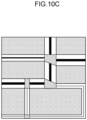
- Fig. 10A to Fig. 10D are diagrams showing the presentation examples of the map based on the data structure generated by the information processing device 10.
- the information processing device 10 may alter colors of the edges in accordance with the meeting conditions of the edges to present the meeting conditions.
- the information processing device 10 may display numbers in vicinities of the edges in accordance with the meeting conditions of the edges to present the meeting conditions.
- the information processing device 10 may alter thicknesses of lines in accordance with the meeting conditions of the edges to present the meeting conditions.
- the information processing device 10 may present the meeting condition of an edge by showing a progress direction of mobile robots in the edge.
- FIG. 11 is a diagram showing an example of the user interface displayed at the display unit 20 by the information processing device 10.
- a user interface 300 is a user interface for causing the information processing device 10 to output a data structure.
- the reference symbol 301 indicates a tab to be selected by a user when the information processing device 10 is to output a data structure based on a map and entry information from the user.
- the reference symbol 302 indicates a tab to be selected by a user when the data structure is to be outputted on the basis of manual settings by the user.
- the reference symbol 303 indicates a text box for entering information relating to the size of a mobile robot. In the example in Fig. 11 , a radius of a mobile robot and a minimum distance from walls of speed-restricted areas may be entered as the information relating to the size of the mobile robot. Obviously, information relating to the sizes of mobile robots is not to be limited by this example.
- the reference symbol 304 indicates an area for selecting constraint items that should be referred to when generating running plans of the mobile robots based on the data structure.
- the constraints to be referred to when generating running plans of mobile robots are now described.
- a map of an area in which plural people and mobile robots are present at the same time includes generally understood expertise, know-how or tacit knowledge for when generating a running plan for a mobile robot.
- the constraints displayed by the information processing device 10 in the area indicated by the reference symbol 304 list these expertise, know-how and tacit knowledge. Eight constraints are presented in the present exemplary embodiment. Examples of constraints, reasons for applying those constraints, and data-driven presentation methods are shown in Table 1. Table 1 No.
- Constraint Reason Data-driven presentation method 1 Apply a one-way area constraint to a narrow edge To prevent mobile robots interfering with each other Voronoi processing and geometric processing 2 Apply a priority passage constraint for passing on one side of an area with multiple travel lanes To reduce time wasted on avoidance movements due to interference Voronoi processing and geometric processing 3 Apply a speed restriction to the vicinity of a goal To reduce positioning errors on arrival at the goal Geometric processing 4 Apply a speed-restricted area to the vicinity of a boundary with an imaginary wall To reduce a risk of contact with a person, workbench or such in a mixed traffic area with workers Voronoi processing and geometric processing 5 Provide a refuge zone at an area in which passage is unavoidable For a mobile robot to wait for passage when another mobile robot is passing along a narrow travel lane Voronoi processing 6 Apply a speed restriction to a passage with a width close to the width of a mobile robot To reduce a risk of contact between the mobile robot and a wall Voronoi processing and geometric processing 7 Apply a priority passage
- Fig. 12A to Fig. 12D are diagrams describing processing in cases of data-driven extraction of map information.
- Fig. 12A and Fig. 12B are diagrams describing processing when constraint No. 7 in Table 1 is set.
- the CPU 12 extracts an open space with a number of connected endpoints in a Voronoi graph and links connection points between the open space and the edges in a graph of all connections to define a priority passage line.
- Fig. 12C is a diagram describing processing when constraints Nos. 1, 2 and 6 in Table 1 are set. In this situation, the CPU 12 defines (travel lanes ⁇ N) circles centered on Voronoi end points.
- Fig. 12D is a diagram describing processing when constraint No. 8 in Table 1 is set. In this situation, the CPU 12 uses a characteristic of only a single Voronoi line extending toward a wall to define turning points at locations corresponding to turning points of an edge and applies speed-restricted areas.
- the CPU 12 finds a Voronoi endpoint that is closest to the goal position and plots an inscribed circle that is centered on the Voronoi endpoint and inscribed between imaginary walls to define a speed-restricted area.
- the CPU 12 defines a speed-restricted area by plotting an inscribed circle that is centered on a Voronoi endpoint and contacts the imaginary wall, reducing the radius of the circle by an amount corresponding to the speed-restricted area, making the imaginary wall bulge by morphology processing, and finding a difference from original coordinates.
- Fig. 13 is a diagram showing an example of a data structure generated by the information processing device 10.
- the upper section of Fig. 13 is the same as the upper section of Fig. 7 .
- the middle section of Fig. 13 is a table data structure storing information of an open space. This table stores information of an ID identifying the open space (OS-ID), a capacity of the open space, a surface area of the open space, nodes connected to the open space (connected node-IDs), and constraints of the open space.
- the lower section of Fig. 13 is a table data structure storing information of an edge. This table stores information of an edge ID, a start point node, an end point node, a meeting condition, a length of the edge, and constraints of the edge.
- Fig. 14 is a diagram showing an example of the user interface displayed at the display unit 20 by the information processing device 10.
- the example shown in Fig. 14 is a user interface that displays information based on the data structure generated by the information processing device 10 superimposed on a map. Because the information processing device 10 displays the information based on the data structure superimposed on the map, a user may anticipate states of movement of mobile robots on the map.
- the information processing device 10 generating and outputting the data structure as described above may contribute to a reduction in labor for creating running plans of the mobile robots.
- Fig. 15 is a diagram describing variations of creation of running plans for mobile robots.
- the column at the left side of Fig. 15 depicts a mode in which only general areas on a route along which mobile robots are to pass are designated from a server controlling running of the mobile robots. Movements in these areas are entrusted to control by autonomous running of the mobile robots. Interference avoidance between the mobile robots is left to autonomous control by the mobile robots.
- the column at the right side of Fig. 15 depicts a mode in which trajectories for mobile robots are designated from the server side as series of waypoints, which are more specific spatial coordinates. In this mode, avoidance of interference between the mobile robots may be commanded from the server side.
- Fig. 15 depicts examples of formulating path plans with consideration for kinematics or dynamics of the mobile robots. For example, path plans are optimized with consideration for characteristics such as the mobile robots travelling fast in straight lines and travelling slowly when turning.
- the lower row of Fig. 15 depicts examples of formulating path plans without consideration for kinematics or dynamics of the mobile robots. In these examples, it is assumed that the mobile robots will operate cautiously and required path times are treated as being proportional to path lengths and the like.
- the information processing device 10 quantifies and solves an MAPF (multi-agent path finding) problem for the extracted roadmap under constraints that take account of the dynamics of the mobile robots.
- the information processing device 10 may use collision determination information such as meeting conditions, capacities and the like in the roadmap areas to reduce optimization search computing.
- the information processing device 10 quantifies and solves an MAPF problem for the extracted roadmap, treating movements of the mobile robots as uniform-speed linear running.
- the information processing device 10 may use collision determination information such as meeting conditions, capacities and the like in the roadmap areas to reduce optimization search computing.
- the respective extracted areas are indicated by, respectively, symbols n1 to n5 for open spaces and e1 to e7 for edges.
- the information processing device 10 defines constraints that take account of dynamics of the mobile robots at grid points, and solves an MAPF problem and a motion planning problem simultaneously.
- the information processing device 10 may use roadmap area information including the grid points to alter definitions of dynamics between the grid points (for example, in passages and at intersections) to reduce computing quantities.
- the information processing device 10 may use collision determination information such as meeting conditions, capacities and the like in the roadmap areas to reduce optimization search computing.
- the information processing that, in the exemplary embodiment described above, is executed by a CPU reading software (a program) may be executed by various kinds of processor other than a CPU.
- processors in these cases include a PLD (programmable logic device) in which a circuit configuration can be modified after manufacturing, such as an FPGA (field-programmable gate array) or the like, a dedicated electronic circuit which is a processor with a circuit configuration that is specially designed to execute specific processing, such as an ASIC (application-specific integrated circuit) or the like, and so forth.
- the information processing may be executed by one of these various kinds of processors, and may be executed by a combination of two or more processors of the same or different kinds (for example, plural FPGAs, a combination of a CPU with an FPGA, or the like).
- Hardware structures of these various kinds of processors are, to be more specific, electronic circuits combining circuit components such as semiconductor components and the like.
- a mode is described in which the information program is memorized in advance (installed) at the ROM or storage, but this is not limiting.
- the program may be provided in a mode that is recorded at a non-transitory recording medium such as a CD-ROM (compact disc read-only memory), DVD-ROM (digital versatile disc read-only memory), USB (universal serial bus) memory or the like.
- a non-transitory recording medium such as a CD-ROM (compact disc read-only memory), DVD-ROM (digital versatile disc read-only memory), USB (universal serial bus) memory or the like.
- Modes are also possible in which the programs are downloaded from external equipment via a network.
Landscapes
- Engineering & Computer Science (AREA)
- Radar, Positioning & Navigation (AREA)
- Remote Sensing (AREA)
- Physics & Mathematics (AREA)
- General Physics & Mathematics (AREA)
- Automation & Control Theory (AREA)
- Aviation & Aerospace Engineering (AREA)
- Human Computer Interaction (AREA)
- Manufacturing & Machinery (AREA)
- Control Of Position, Course, Altitude, Or Attitude Of Moving Bodies (AREA)
- Instructional Devices (AREA)
- Navigation (AREA)
- Traffic Control Systems (AREA)
Abstract
Description
- The present invention relates to an information processing device, an information processing method and a computer program.
- Technologies for using a predetermined map to generate a movement plan for a mobile robot have been proposed. For example,
Patent Reference 1 discloses a technology that: uses a geometric map of objects in an environment to generate a grid map representing a distribution of spaces occupied by objects that stochastically represents positions and attitudes; uses distances corresponding to uncertainties in the positions and attitudes of the objects from the grid map to generate a Voronoi diagram; and, using collision probabilities with objects in the Voronoi diagram and path lengths as costs, performs a search for a path from an assigned start point to a destination. - Patent Document 1: Japanese Patent Application Laid-Open (
JP-A) No. 2005-032196 - A conventional technology uses a geometric map of objects in an environment to generate a movement plan for a mobile robot, but gives no consideration to a movement plan for plural mobile robots. In order to manage a collection of mobile robots without complexity, one-way areas and restricted-number areas are provided in the geometric map and paths avoiding previous mobile robots are formed. However, suitably specifying avoidance paths requires human labor and is inefficient.
- The present invention is devised in consideration of the matter described above. An object of the present invention is to provide an information processing device, an information processing method and a computer program that output a data structure that may manage a collection of mobile robots more efficiently than conventional technology.
- In order to achieve the object described above, an information processing device according to the present invention includes: an acquisition unit that acquires a map that distinguishes a passable area for mobile robots from an impassable area and information relating to a size of the robots; a processing unit that divides the passable area of the map into a first area in which a travel direction of the robots is determined and a second area in which a travel direction of the robots is not determined, and uses the information relating to the size of the robots to generate a predetermined data structure storing information on whether or not the robots can pass by each other in the first area as first area information and storing information on a number of the robots that can be present simultaneously as second area information; and an output unit that outputs the data structure generated by the processing unit. Thus, the information processing device may output a data structure that may manage a collection of mobile robots efficiently.
- The processing unit may store information relating to a limit on movements of the robots in the first area or the second area in the data structure. Thus, the information processing device may output information relating to limits on movements of the robots.
- The acquisition unit may acquire information relating to the limit that is entered by a user. Thus, the information processing device may output information relating to limits entered by a user.
- The processing unit may store information of a surface area of the second area in the data structure as the second area information. Thus, the information processing device may output information on the surface area of an area in which no travel direction of the robots is determined.
- The processing unit may store information relating to a progress direction of the robots in the data structure as information relating to the first area. Thus, the information processing device may output information relating to progress directions of the robots.
- The processing unit may extract the second area from the passable area, and extract the first area from the passable area excluding the extracted second area. Thus, the information processing device may set areas that are not areas in which travel directions of the robots are not determined to be areas in which travel directions of the robots are determined.
- The acquisition unit may acquire information relating to sizes of the robots that differs between types of the robots. Thus, the information processing device may output a data structure based on the information relating to the sizes of the robots.
- The information processing device may further include a display control unit that causes the map to be displayed, the displayed map reproducing information stored in the data structure. Thus, the information processing device may visually present the information stored in the data structure in a map.
- The processing unit may generate a path plan of the robots based on of information stored in the data structure. Thus, the information processing device may generate path plans for robots from the information stored in the data structure.
- In order to achieve the object described above, an information processing method according to the present invention includes: acquiring a map that distinguishes a passable area for mobile robots from an impassable area and information relating to a size of the robots; generating a predetermined data structure, including dividing the passable area of the map into a first area in which a travel direction of the robots is determined and a second area in which a travel direction of the robots is not determined, and using the information relating to the size of the robots to generate the data structure, the data structure storing information on whether or not the robots can pass by each other in the first area as first area information and storing information on a number of the robots that can be present simultaneously as second area information; and outputting the generated data structure. Thus, the information processing method may output a data structure that may manage a collection of mobile robots efficiently.
- In order to achieve the object described above, a computer program according to the present invention causes a computer to execute processing including: acquiring a map that distinguishes a passable area for mobile robots from an impassable area and information relating to a size of the robots; generating a predetermined data structure, including dividing the passable area of the map into a first area in which a travel direction of the robots is determined and a second area in which a travel direction of the robots is not determined, and using the information relating to the size of the robots to generate the data structure, the data structure storing information on whether or not the robots can pass by each other in the first area as first area information and storing information on a number of the robots that can be present simultaneously as second area information; generating the predetermined data structure storing the first area information and the second area information; and outputting the generated data structure. Thus, the computer program may output a data structure that may manage a collection of mobile robots efficiently.
- According to the present invention, an information processing device, information processing method and computer program may be provided that utilize information on sizes of mobile robots to output a data structure that may manage a collection of the mobile robots more efficiently than conventional technology.
-
-
Fig. 1 is a block diagram showing hardware structures of an information processing device according to an exemplary embodiment. -
Fig. 2 is a block diagram showing an example of functional structures of the information processing device. -
Fig. 3 is a flowchart showing a flow of information processing by the information processing device. -
Fig. 4 is a flowchart showing a flow of information processing by the information processing device. -
Fig. 5 is a diagram showing a state in which the information processing device extracts open spaces and edges from a map. -
Fig. 6A to Fig. 6J are diagrams showing states in which the information processing device extracts open spaces and edges from the map. -
Fig. 7 is a diagram showing an example of a data structure generated by the information processing device. -
Fig. 8 is a diagram showing a state in which the information processing device extracts open spaces and edges from the map. -
Fig. 9 is a diagram showing an example of a data structure generated by the information processing device. -
Fig. 10A is a diagram showing a presentation example of a map based on a data structure generated by the information processing device. -
Fig. 10B is a diagram showing a presentation example of a map based on a data structure generated by the information processing device. -
Fig. 10C is a diagram showing a presentation example of a map based on a data structure generated by the information processing device. -
Fig. 10D is a diagram showing a presentation example of a map based on a data structure generated by the information processing device. -
Fig. 11 is a diagram showing an example of a user interface displayed at a display unit by the information processing device. -
Fig. 12A is a diagram describing processing in a case of data-driven extraction of map information. -
Fig. 12B is a diagram describing processing in a case of data-driven extraction of map information. -
Fig. 12C is a diagram describing processing in a case of data-driven extraction of map information. -
Fig. 12D is a diagram describing processing in a case of data-driven extraction of map information. -
Fig. 13 is a diagram showing an example of a data structure generated by the information processing device. -
Fig. 14 is a diagram showing an example of a user interface displayed at the display unit by the information processing device. -
Fig. 15 is a diagram describing variations of creation of running plans for mobile robots. - Below, an example of an embodiment of the present invention is described with reference to the drawings. In the drawings, the same reference symbols are assigned to structural elements and portions that are the same or equivalent. Proportional dimensions in the drawings may be exaggerated to aid understanding and may be different from actual proportions.
-
Fig. 1 is a block diagram showing hardware structures of aninformation processing device 10 according to the present exemplary embodiment. Theinformation processing device 10 according to the present exemplary embodiment generates and outputs a predetermined data structure on the basis of information relating to a map, which distinguishes passable areas and impassable areas for mobile robots, and information relating to sizes of the robots. Because theinformation processing device 10 according to the present exemplary embodiment generates and outputs this data structure, a collection of mobile robots may be managed efficiently. Robots that are objects of control in the present exemplary embodiment are autonomous mobile robots (AMR). - As shown in
Fig. 1 , theinformation processing device 10 includesmemory 11, a central processing unit (CPU) 12, avideo adaptor 13, aserial port interface 14, a harddisc drive interface 15 and a hard disc drive 16. These structures are connected to be capable of communicating with one another via abus 19. - The
memory 11 is a memory device formed with, for example, read-only memory (ROM) and random access memory (RAM) or the like. The ROM memorizes various programs and various kinds of data. The RAM serves as a work area and temporarily memorizes programs and data. - The
CPU 12 is a central arithmetic processing unit, which executes various programs and controls various sections. That is, theCPU 12 reads a program from the ROM of thememory 11 or the hard disc drive 16 and executes the program using thememory 11 or the RAM as a work area. TheCPU 12 performs control of the structures described above and various kinds of arithmetic processing in accordance with the program recorded in the ROM of thememory 11 or the hard disc drive 16. In the present exemplary embodiment, an information processing program that generates and outputs a predetermined data structure is stored in the ROM of thememory 11 or the hard disc drive 16. - The
video adaptor 13 is connected to adisplay unit 20. Thevideo adaptor 13 outputs various kinds of information to thedisplay unit 20 to be displayed at thedisplay unit 20. Thedisplay unit 20 is any of various information display devices such as a liquid crystal display, an organic electroluminescent display or the like. - The
serial port interface 14 is connected to amouse 30 and akeyboard 40. Theserial port interface 14 outputs details of entries by a user operating themouse 30 andkeyboard 40 to theCPU 12. - The hard disc drive 16 stores various programs, including an operating system, and various kinds of data. The hard disc drive 16 conducts reading and writing of the data and programs via the hard
disc drive interface 15. - When the aforementioned information processing program is executed, the
information processing device 10 uses the hardware resources described above to realize various functions. Functional structures realized by theinformation processing device 10 are now described. -
Fig. 2 is a block diagram showing an example of the functional structures of theinformation processing device 10. - As shown in
Fig. 2 , as functional structures, theinformation processing device 10 includes anacquisition unit 101, aprocessing unit 102, anoutput unit 103, adisplay control unit 104 and aretention unit 105. These functional structures are realized by theCPU 12 reading and executing the information processing program memorized in the ROM of thememory 11 or the hard disc drive 16. - The
acquisition unit 101 acquires a map that distinguishes passable areas and impassable areas for mobile robots (below referred to as "the mobile robots") andspecification information 111 relating to sizes of the mobile robots. The map is, for example, a map in which obstacles that are impassable for the mobile robots are represented in a coordinate system, a map in which passable areas and impassable areas are represented by bits, a map formed of point group information acquired by lidar (light detection and ranging) or the like. - The
processing unit 102 generates a predetermined data structure on the basis of information acquired by theacquisition unit 101. More specifically, theprocessing unit 102 divides passable areas for mobile robots in the map acquired by theacquisition unit 101 into edges and open spaces. An edge is an area in which a travel direction of the mobile robots is determined, and is an example of a first area recited in the present invention. An open space is an area in which a travel direction of the mobile robots is not determined, and is an example of a second area recited in the present invention. - The
processing unit 102 uses the information relating to sizes of the mobile robots to determine, as edge information, passing possibility information that determines whether or not the mobile robots can pass by or overtake each other in an edge. Theprocessing unit 102 stores passing possibility information of the edges in the predetermined data structure as meeting conditions of the edges. A meeting condition of an edge is a condition limiting whether plural mobile robots can pass by each other. Edge meeting condition information is expressed as, for example, information on a number of the mobile robots that can travel side by side at the same time or a number of the mobile robots that can pass by each other. Information on a number of robots may be represented in, for example, a format of a number of travel lanes that the mobile robots progress along side by side. That is, an edge where there is only one travel lane is an edge where the mobile robots may not travel side by side at the same time or may not pass by each other, and an edge where the number of travel lanes is two or more is an edge where the robots may travel side by side at the same time or pass by each other. Edge meeting condition information may also be expressed as information on a narrowest part of a passage. Theprocessing unit 102 also stores information on a number of robots that may be present in an open space at the same time in the data structure as open space information. Theprocessing unit 102 generates a data structure storing this information. - The
processing unit 102 extracts open spaces from passable areas of the map and extracts edges from passable areas excluding the extracted open spaces. More specific open space and edge extraction methods are described in more detail below. - The
processing unit 102 may store information in the data structure relating to constraints on movements of the mobile robots in the edges and open spaces. The information relating to constraints on movements of the mobile robots may be acquired by theacquisition unit 101. Theprocessing unit 102 may further store information on surface areas of the open spaces in the data structure as open space information. Theprocessing unit 102 may further store information relating to progress directions of the mobile robots in the data structure as information relating to the edges. Specific examples of information stored in the data structure are described in more detail below. - The
processing unit 102 executes processing to generate movement plans of the mobile robots on the basis of the generated data structure. Generation of a movement plan of a mobile robot on the basis of the data structure is described in more detail below. - The
processing unit 102 may compute passing possibility information on the basis of a minimum passage width determined for a progress direction in an edge area. Theprocessing unit 102 may compute the capacity of an open space on the basis of the shape of the open space. Theprocessing unit 102 may find passing possibility information and open space capacities by conducting running simulations so as to improve throughput. The meaning of the term "throughput" as used in the present exemplary embodiment is intended to encompass an operating efficiency of the mobile robots. Theprocessing unit 102 may also find passing possibility information and open space capacities by actually running mobile robots such that throughput improves and using data obtained by the running of mobile robots. - The
output unit 103 outputs a data structure generated by theprocessing unit 102. The data structure outputted by theoutput unit 103 may be stored by theretention unit 105. Thedisplay control unit 104 performs control to display a user interface at thedisplay unit 20. More specifically, thedisplay control unit 104 performs control to display a user interface reproducing the data structure outputted by theoutput unit 103 at thedisplay unit 20. An example of the user interface displayed at thedisplay unit 20 by thedisplay control unit 104 is described below. Theretention unit 105 retains amap 112 of a location in which the mobile robots are to move. - Because the
information processing device 10 according to the exemplary embodiment of the present invention includes these structures, theinformation processing device 10 may output a data structure using information on the sizes of mobile robots. Because theinformation processing device 10 according to the exemplary embodiment of the present invention uses information on the sizes of the mobile robots, theinformation processing device 10 may output a data structure for managing a collection of mobile robots more efficiently than conventional technology. - Now, operation of the
information processing device 10 is described. -
Fig. 3 is a flowchart showing a flow of information processing by theinformation processing device 10. TheCPU 12 performs this information processing by reading an information processing program memorized in the ROM of thememory 11 or the hard disc drive 16, loading the information processing program into the RAM of thememory 11, and executing the information processing program. - The flowchart shown in
Fig. 3 is a flowchart of processing in which theinformation processing device 10 outputs a data structure. First, in step S101, theCPU 12 accepts entry of specification information for output of the data structure. The entry of the specification information may be conducted by a predetermined user interface. Details of a user interface are described below. The specification information accepted by theCPU 12 in step S101 includes information relating to sizes of mobile robots. The information relating to the size of a mobile robot is, for example, information on a radius of the mobile robot when a shape of the mobile robot is circular or information on the radius of a circumscription circle of the mobile robot when the shape of the mobile robot is not circular. TheCPU 12 may also accept information of a buffer distance from walls of passages that the mobile robot is to move along. - When the entry of specification information has been accepted, in step S102 the
CPU 12 extracts open space candidate points from areas that are passable for the mobile robots in accordance with a predetermined extraction method. A specific example of the extraction method of open space candidate points is described below. - When the open space candidate points have been extracted, in step S103 the
CPU 12 selects open spaces from the extracted candidate points in accordance with a predetermined selection method. Plural open spaces may be selected. A specific example of an open space selection method is described below. - When the open spaces have been selected, in step S104 the
CPU 12 calculates an open space capacity of each selected open space. The meaning of the term "open space capacity" as used herein is intended to include a number of the mobile robots that may be present in the open space at the same time. Accordingly, theCPU 12 uses the information on the sizes of the mobile robots to calculate the open space capacities. - When the open space capacities have been calculated, in step S105 the
CPU 12 defines areas other than open spaces in the passable areas for mobile robots as edges. - When areas other than open spaces have been defined as the edges, in step S106 the
CPU 12 computes meeting conditions of the edges in accordance with a predetermined computation method. A meeting condition of an edge is expressed as a number of the mobile robots that may travel side by side along the edge or pass by each other. A computation method of meeting conditions of edges is described below. - When the meeting conditions of edges have been computed, in step S107 the
CPU 12 outputs generated nodes and edges as a data structure. A specific example of the data structure is described below. -
Fig. 4 is a flowchart showing a flow of information processing by theinformation processing device 10. TheCPU 12 performs this information processing by reading an information processing program memorized in the ROM of thememory 11 or the hard disc drive 16, loading the information processing program into the RAM of thememory 11, and executing the information processing program. The flowchart shown inFig. 4 is a flow of information processing when the flowchart of information processing shown inFig. 3 is implemented with a Voronoi diagram. - First, in step S111, the
CPU 12 accepts entry of specification information for output of a data structure. The entry of the specification information may be conducted by a predetermined user interface. - When the entry of specification information has been accepted, in step S112 the
CPU 12 reads a map from theretention unit 105 and generates a Voronoi graph of boundaries between passable areas and impassable areas for mobile robots in the map in accordance with a coordinate system. - When the Voronoi graph has been generated, in step S113 the
CPU 12 extracts points for which a number of connecting endpoints of the Voronoi graph is at least three as open space points. - When an open space candidate point has been extracted, in step S114 the
CPU 12 plots a circle that is centered on an open space point and tangential with an obstacle, and computes the radius of the circle. The obstacle is a boundary between a passable area and an impassable area for mobile robots such as, for example, a wall or the like. - When the radii of the circles have been computed, in step S115 the
CPU 12 determines open space capacities. TheCPU 12 may, for example, use the radius of each circle and a radius of the mobile robots to determine the open space capacities. For example, if the radius of a circle is not more than twice the radius of the mobile robots, only one of the mobile robots may be present in the open space at the same time, and theCPU 12 determines that the open space capacity is one. - When the open space capacities have been determined, in step S116 the
CPU 12 sets connection points between the open spaces and edges as new nodes. - When the connection points between the open spaces and edges have been set as new nodes, in step S117 the
CPU 12 finds a radius of an inscribed circle that is centered on an endpoint of the Voronoi graph and inscribed between obstacles. - When the radii of the inscribed circles have been found, in step S118 the
CPU 12 finds meeting conditions of the edges from the radii of the inscribed circles. A meeting condition of an edge is expressed as a number of the mobile robots that may travel side by side along the edge or pass by each other. TheCPU 12 may, for example, use the radius of an inscribed circle and the radius of the mobile robots to determine the meeting condition of an edge. For example, if the radius of the inscribed circle is not more than twice the radius of the mobile robots, only one of the mobile robots may pass along the edge at the same time, and theCPU 12 determines that the meeting condition of the edge is one robot. - A situation in which there are plural types of mobile robots and the sizes of the types are different is considered. Assume there are three types of mobile robots, AMR1, AMR2 and AMR3, and that the width of an AMR1 is 1.0, the width of an AMR2 is 1.5, and the width of an AMR3 is 1.7. These values are normalized using the width of AMR1 that has the smallest width as a unit. If a passage width (a number of travel lanes) is 3.0, up to three AMR1s may travel side by side or pass by each other. Meanwhile, up to two AMR2s may travel side by side or pass by each other. AMR3s cannot travel side by side or pass by each other. Two robots that are an AMR1 and an AMR2 may travel side by side and may pass by each other. Two robots that are an AMR1 and an AMR3 may travel side by side and may pass by each other. An AMR2 and an AMR3 cannot travel side by side and cannot pass by each other. Thus, the
CPU 12 determines meeting conditions in accordance with the types of the mobile robots. Of course, when meeting conditions are being found, numerical values of actual sizes of the mobile robots may be used rather than normalized values of the sizes of the mobile robots. - When the meeting conditions of the mobile robots have been found from the radii of the inscribed circles, in step S119 the
CPU 12 outputs generated nodes and edges as a data structure. - When the
information processing device 10 according to the exemplary embodiment of the present invention executes this processing, theinformation processing device 10 may output a data structure using information on sizes of the mobile robots. Because theinformation processing device 10 according to the exemplary embodiment of the present invention uses the information on sizes of the mobile robots, theinformation processing device 10 may output a data structure for managing a collection of mobile robots more efficiently than conventional technology. - The
CPU 12 may define open spaces by a method other than a Voronoi diagram, for example, a probabilistic roadmap, a rapidly exploring random tree (RRT) or the like. - Now, an example of generation of a specific data structure by the
information processing device 10 is illustrated. -
Fig. 5 is a diagram showing a state in which theinformation processing device 10 extracts open spaces and edges from a map. When amap 200 is provided to theinformation processing device 10, theinformation processing device 10 extracts open spaces and edges from themap 200. Referring to the region of themap 200 indicated with thereference symbol 210, theinformation processing device 10 applies an ID of the form "A1" to an open space and applies an ID of the form "e1" to an edge between nodes v1 and v2. Theinformation processing device 10 generates information that expresses a meeting condition for each edge as a number of travel lanes. Theinformation processing device 10 then stores the information of the open spaces and edges in a data structure. On the basis of this data structure, theinformation processing device 10 may visually present where open spaces are, where edges are, and what meeting conditions the edges have, as illustrated inFig. 5 . -
Fig. 6A to Fig. 6J are diagrams, based on the flowchart shown inFig. 4 , showing states in which the information processing device extracts open spaces and edges from the map. - When the
map 200 as illustrated inFig. 6A is provided to theinformation processing device 10, theinformation processing device 10 generates a Voronoi graph of boundaries between passable areas and impassable areas for mobile robots in the map in accordance with a coordinate system, as illustrated inFig. 6B . When the Voronoi graph has been generated, as shown inFig. 6C , theinformation processing device 10 extracts points where a number of connecting endpoints in the Voronoi graph is at least three as open space points. When the open space candidate points have been extracted, as illustrated inFig. 6D , theinformation processing device 10 plots circles that are centered on the open space points and tangential with obstacles, and computes the radii of these circles. The obstacles are boundaries between passable areas and impassable areas for the mobile robots, such as, for example, walls and the like. - When the circles that are centered on open space points and tangential with obstacles have been plotted and the radii of the circles have been computed, as illustrated in
Fig. 6E , theinformation processing device 10 finds a number of contact points between each circle and the obstacles, and increases the radius of the circle until the number of contact points is twice the aforementioned number of connecting endpoints in the Voronoi graph. Then, as illustrated inFig. 6F , theinformation processing device 10 adjusts distances between the contact points such that each distance between contact points is not less than a predetermined threshold value. As illustrated inFig. 6G , theinformation processing device 10 then connects the obtained contact points with one another to generate an open space. - When capacities of the open spaces have been determined, as illustrated in
Fig. 6H , theinformation processing device 10 sets connection points between the open spaces and the edges as new nodes. When the connection points between the open spaces and edges have been set as new nodes, as illustrated inFig. 6I , theinformation processing device 10 finds radii of inscribed circles that are centered on endpoints of the Voronoi graph and inscribed between obstacles. - When the radii of the inscribed circles have been found, as illustrated in
Fig. 6J , theinformation processing device 10 finds meeting conditions of the edges from the radii of the inscribed circles. When theinformation processing device 10 has found the meeting conditions for mobile robots from the radii of the inscribed circles, theinformation processing device 10 outputs the generated nodes and edges as the data structure. Thus, when themap 200 is provided, theinformation processing device 10 may output a data structure based on the content of themap 200. -
Fig. 7 is a diagram showing an example of a data structure generated by theinformation processing device 10. The upper section ofFig. 7 is a table data structure storing information of a node. This table stores information of a node ID identifying the node, coordinates of the node, and an ID of an open space connected to the node (connected OS-ID). The values of coordinates in this table are values using an arbitrary point of themap 200 as an origin point. The middle section ofFig. 7 is a table data structure storing information of an open space. This table stores information of an ID identifying the open space (OS-ID), a capacity of the open space, a surface area of the open space, and nodes connected to the open space (connected node-IDs). The lower section ofFig. 7 is a table data structure storing information of an edge. This table stores information of an edge ID, a start point node, an end point node, a meeting condition, and a length of the edge. The start point and end point may both be nodes when a progress direction of the edge is not set. When a progress direction of the edge is set, one or other of the start point and end point is set. - Because the
information processing device 10 generates and outputs the data structure in this way, on the basis of the data structure, theinformation processing device 10 may visually present where the open spaces are, where the edges are and what meeting conditions the edges have, as illustrated inFig. 5 . - In the example shown in
Fig. 7 , information on open spaces and information on edges are stored in respectively separate tables, but the present invention is not limited by this example. Information on open spaces and information on edges may be stored in the same tables. -
Fig. 8 is a diagram showing a state in which theinformation processing device 10 extracts open spaces and edges from the map. When themap 200 is provided to theinformation processing device 10, theinformation processing device 10 extracts open spaces and edges from themap 200. Referring to the region of themap 200 indicated by the reference symbol 21, theinformation processing device 10 applies the ID "v6" to an open space and applies the ID "e1" to an edge between nodes v1 and v2. -
Fig. 9 is a diagram showing an example of a data structure generated by theinformation processing device 10. The upper section ofFig. 9 is a table data structure storing information of an edge. This table stores information of an edge ID, a start point node, an end point node, a meeting condition, and a length of the edge. The start point and end point may both be nodes when a progress direction of the edge is not set. When a progress direction of the edge is set, one or other of the start point and end point is set. The middle section ofFig. 9 is a table data structure storing information of a node. This table stores information of a node ID identifying the node, coordinates of the node, an ID of an open space connected to the node (connected ID), and information on an attribute of these fields. The values of coordinates in this table are values using an arbitrary point of themap 200 as an origin point. Note also that because the concepts of capacity and surface area do not apply to a node, no values are set in the "capacity" and "surface area" fields (or null values are set). The lower section ofFig. 9 is a table data structure storing information of an open space. This table stores information of an ID identifying the open space, a surface area of the open space, a capacity of the open space, information of nodes connected to the open space (connected IDs), and an attribute of these fields. Note that the concept of coordinates does not apply to an open space and no values are set in the "coordinates" field (or null values are set). - The
information processing device 10 may store this information on open spaces and information on edges in the same tables. Because theinformation processing device 10 generates and outputs this data structure, on the basis of the data structure, theinformation processing device 10 may visually present where the open spaces are, where the edges are and what meeting conditions the edges have, as illustrated inFig. 8 . - Now, presentation examples of a map based on a data structure generated by the
information processing device 10 are illustrated.Fig. 10A to Fig. 10D are diagrams showing the presentation examples of the map based on the data structure generated by theinformation processing device 10. For example, as illustrated inFig. 10A , theinformation processing device 10 may alter colors of the edges in accordance with the meeting conditions of the edges to present the meeting conditions. For another example, as shown inFig. 10B , theinformation processing device 10 may display numbers in vicinities of the edges in accordance with the meeting conditions of the edges to present the meeting conditions. For another example, as shown inFig. 10C , theinformation processing device 10 may alter thicknesses of lines in accordance with the meeting conditions of the edges to present the meeting conditions. For another example, as shown inFig. 10D , theinformation processing device 10 may present the meeting condition of an edge by showing a progress direction of mobile robots in the edge. - Now, an example of a user interface displayed by the
information processing device 10 is described.Fig. 11 is a diagram showing an example of the user interface displayed at thedisplay unit 20 by theinformation processing device 10. Auser interface 300 is a user interface for causing theinformation processing device 10 to output a data structure. - The
reference symbol 301 indicates a tab to be selected by a user when theinformation processing device 10 is to output a data structure based on a map and entry information from the user. Thereference symbol 302 indicates a tab to be selected by a user when the data structure is to be outputted on the basis of manual settings by the user. Thereference symbol 303 indicates a text box for entering information relating to the size of a mobile robot. In the example inFig. 11 , a radius of a mobile robot and a minimum distance from walls of speed-restricted areas may be entered as the information relating to the size of the mobile robot. Obviously, information relating to the sizes of mobile robots is not to be limited by this example. - The
reference symbol 304 indicates an area for selecting constraint items that should be referred to when generating running plans of the mobile robots based on the data structure. The constraints to be referred to when generating running plans of mobile robots are now described. A map of an area in which plural people and mobile robots are present at the same time (a mixed traffic area) includes generally understood expertise, know-how or tacit knowledge for when generating a running plan for a mobile robot. The constraints displayed by theinformation processing device 10 in the area indicated by thereference symbol 304 list these expertise, know-how and tacit knowledge. Eight constraints are presented in the present exemplary embodiment. Examples of constraints, reasons for applying those constraints, and data-driven presentation methods are shown in Table 1.Table 1 No. Constraint Reason Data-driven presentation method 1 Apply a one-way area constraint to a narrow edge To prevent mobile robots interfering with each other Voronoi processing and geometric processing 2 Apply a priority passage constraint for passing on one side of an area with multiple travel lanes To reduce time wasted on avoidance movements due to interference Voronoi processing and geometric processing 3 Apply a speed restriction to the vicinity of a goal To reduce positioning errors on arrival at the goal Geometric processing 4 Apply a speed-restricted area to the vicinity of a boundary with an imaginary wall To reduce a risk of contact with a person, workbench or such in a mixed traffic area with workers Voronoi processing and geometric processing 5 Provide a refuge zone at an area in which passage is unavoidable For a mobile robot to wait for passage when another mobile robot is passing along a narrow travel lane Voronoi processing 6 Apply a speed restriction to a passage with a width close to the width of a mobile robot To reduce a risk of contact between the mobile robot and a wall Voronoi processing and geometric processing 7 Apply a priority passage line designating a trajectory of mobile robots within an open space To reduce interference between mobile robots and reduce time wasted on avoiding interference within the open space Voronoi processing, geometric processing and graph processing 8 Apply a speed-restricted area to a turning point To prevent mobile robots over-running at turns Voronoi processing -
Fig. 12A to Fig. 12D are diagrams describing processing in cases of data-driven extraction of map information.Fig. 12A andFig. 12B are diagrams describing processing when constraint No. 7 in Table 1 is set. In this situation, theCPU 12 extracts an open space with a number of connected endpoints in a Voronoi graph and links connection points between the open space and the edges in a graph of all connections to define a priority passage line.Fig. 12C is a diagram describing processing when constraints Nos. 1, 2 and 6 in Table 1 are set. In this situation, theCPU 12 defines (travel lanes × N) circles centered on Voronoi end points.Fig. 12D is a diagram describing processing when constraint No. 8 in Table 1 is set. In this situation, theCPU 12 uses a characteristic of only a single Voronoi line extending toward a wall to define turning points at locations corresponding to turning points of an edge and applies speed-restricted areas. - When constraint No. 3 in Table 1 is set, the
CPU 12 finds a Voronoi endpoint that is closest to the goal position and plots an inscribed circle that is centered on the Voronoi endpoint and inscribed between imaginary walls to define a speed-restricted area. When constraint No. 4 in Table 1 is set, theCPU 12 defines a speed-restricted area by plotting an inscribed circle that is centered on a Voronoi endpoint and contacts the imaginary wall, reducing the radius of the circle by an amount corresponding to the speed-restricted area, making the imaginary wall bulge by morphology processing, and finding a difference from original coordinates. -
Fig. 13 is a diagram showing an example of a data structure generated by theinformation processing device 10. In the data structure shown inFig. 13 , constraints designated by a user are added to the data structure shown inFig. 7 . The upper section ofFig. 13 is the same as the upper section ofFig. 7 . The middle section ofFig. 13 is a table data structure storing information of an open space. This table stores information of an ID identifying the open space (OS-ID), a capacity of the open space, a surface area of the open space, nodes connected to the open space (connected node-IDs), and constraints of the open space. The lower section ofFig. 13 is a table data structure storing information of an edge. This table stores information of an edge ID, a start point node, an end point node, a meeting condition, a length of the edge, and constraints of the edge. -
Fig. 14 is a diagram showing an example of the user interface displayed at thedisplay unit 20 by theinformation processing device 10. The example shown inFig. 14 is a user interface that displays information based on the data structure generated by theinformation processing device 10 superimposed on a map. Because theinformation processing device 10 displays the information based on the data structure superimposed on the map, a user may anticipate states of movement of mobile robots on the map. - The
information processing device 10 generating and outputting the data structure as described above may contribute to a reduction in labor for creating running plans of the mobile robots. -
Fig. 15 is a diagram describing variations of creation of running plans for mobile robots. The column at the left side ofFig. 15 depicts a mode in which only general areas on a route along which mobile robots are to pass are designated from a server controlling running of the mobile robots. Movements in these areas are entrusted to control by autonomous running of the mobile robots. Interference avoidance between the mobile robots is left to autonomous control by the mobile robots. The column at the right side ofFig. 15 depicts a mode in which trajectories for mobile robots are designated from the server side as series of waypoints, which are more specific spatial coordinates. In this mode, avoidance of interference between the mobile robots may be commanded from the server side. Autonomous control by the mobile robots is used for purposes of avoiding interference with uncontrolled objects such as people and the like. The upper row inFig. 15 depicts examples of formulating path plans with consideration for kinematics or dynamics of the mobile robots. For example, path plans are optimized with consideration for characteristics such as the mobile robots travelling fast in straight lines and travelling slowly when turning. The lower row ofFig. 15 depicts examples of formulating path plans without consideration for kinematics or dynamics of the mobile robots. In these examples, it is assumed that the mobile robots will operate cautiously and required path times are treated as being proportional to path lengths and the like. - In the example at the upper left of
Fig. 15 , theinformation processing device 10 quantifies and solves an MAPF (multi-agent path finding) problem for the extracted roadmap under constraints that take account of the dynamics of the mobile robots. In the example at the upper left ofFig. 14 , theinformation processing device 10 may use collision determination information such as meeting conditions, capacities and the like in the roadmap areas to reduce optimization search computing. - In the example at the lower left of
Fig. 15 , theinformation processing device 10 quantifies and solves an MAPF problem for the extracted roadmap, treating movements of the mobile robots as uniform-speed linear running. In the example at the lower left ofFig. 15 , theinformation processing device 10 may use collision determination information such as meeting conditions, capacities and the like in the roadmap areas to reduce optimization search computing. In the example at the lower left ofFig. 15 , the respective extracted areas are indicated by, respectively, symbols n1 to n5 for open spaces and e1 to e7 for edges. - In the example at the upper right of
Fig. 15 , theinformation processing device 10 defines constraints that take account of dynamics of the mobile robots at grid points, and solves an MAPF problem and a motion planning problem simultaneously. Theinformation processing device 10 may use roadmap area information including the grid points to alter definitions of dynamics between the grid points (for example, in passages and at intersections) to reduce computing quantities. In the example at the upper right ofFig. 15 , theinformation processing device 10 may use collision determination information such as meeting conditions, capacities and the like in the roadmap areas to reduce optimization search computing. - The information processing that, in the exemplary embodiment described above, is executed by a CPU reading software (a program) may be executed by various kinds of processor other than a CPU. Examples of processors in these cases include a PLD (programmable logic device) in which a circuit configuration can be modified after manufacturing, such as an FPGA (field-programmable gate array) or the like, a dedicated electronic circuit which is a processor with a circuit configuration that is specially designed to execute specific processing, such as an ASIC (application-specific integrated circuit) or the like, and so forth. The information processing may be executed by one of these various kinds of processors, and may be executed by a combination of two or more processors of the same or different kinds (for example, plural FPGAs, a combination of a CPU with an FPGA, or the like). Hardware structures of these various kinds of processors are, to be more specific, electronic circuits combining circuit components such as semiconductor components and the like.
- In the exemplary embodiment described above, a mode is described in which the information program is memorized in advance (installed) at the ROM or storage, but this is not limiting. The program may be provided in a mode that is recorded at a non-transitory recording medium such as a CD-ROM (compact disc read-only memory), DVD-ROM (digital versatile disc read-only memory), USB (universal serial bus) memory or the like. Modes are also possible in which the programs are downloaded from external equipment via a network.
-
- 10
- information processing device
- 200
- Map
- 300
- User interface
Claims (11)
- An information processing device, comprising:an acquisition unit that acquires:a map that distinguishes a passable area for mobile robots from an impassable area, andinformation relating to a size of the robots;a processing unit that:divides the passable area of the map into a first area in which a travel direction of the robots is determined and a second area in which a travel direction of the robots is not determined, anduses the information relating to the size of the robots to generate a predetermined data structure storing information on whether or not the robots can pass by each other in the first area as first area information and storing information on a number of the robots that can be present simultaneously as second area information; andan output unit that outputs the data structure generated by the processing unit.
- The information processing device according to claim 1, wherein the processing unit stores information relating to a limit on movements of the robots in the first area or the second area in the data structure.
- The information processing device according to claim 2, wherein the acquisition unit acquires information relating to the limit that is entered by a user.
- The information processing device according to any one of claims 1 to 3, wherein the processing unit stores information of a surface area of the second area in the data structure as the second area information.
- The information processing device according to any one of claims 1 to 4, wherein the processing unit stores information relating to a progress direction of the robots in the data structure as information relating to the first area.
- The information processing device according to any one of claims 1 to 5, wherein the processing unit:extracts the second area from the passable area, andextracts the first area from the passable area excluding the extracted second area.
- The information processing device according to any one of claims 1 to 6, wherein the acquisition unit acquires information relating to sizes of the robots that differs between types of the robots.
- The information processing device according to any one of claims 1 to 7, further comprising a display control unit that causes the map to be displayed, the displayed map reproducing information stored in the data structure.
- The information processing device according to any one of claims 1 to 8, wherein the processing unit generates a path plan of the robots based on information stored in the data structure.
- An information processing method, comprising:acquiring a map that distinguishes a passable area for mobile robots from an impassable area, and information relating to a size of the robots;generating a predetermined data structure, including:dividing the passable area of the map into a first area in which a travel direction of the robots is determined and a second area in which a travel direction of the robots is not determined, andusing the information relating to the size of the robots to generate the data structure, the data structure storing information on whether or not the robots can pass by each other in the first area as first area information and storing information on a number of the robots that can be present simultaneously as second area information; and outputting the generated data structure.
- A computer program for causing a computer to execute processing, the processing comprising:acquiring a map that distinguishes a passable area for mobile robots from an impassable area, and information relating to a size of the robots;generating a predetermined data structure, including:dividing the passable area of the map into a first area in which a travel direction of the robots is determined and a second area in which a travel direction of the robots is not determined, andusing the information relating to the size of the robots to generate the data structure, the data structure storing information on whether or not the robots can pass by each other in the first area as first area information and storing information on a number of the robots that can be present simultaneously as second area information;generating the predetermined data structure storing the first area information and the second area information; andoutputting the generated data structure.
Applications Claiming Priority (2)
| Application Number | Priority Date | Filing Date | Title |
|---|---|---|---|
| JP2021182662A JP7779092B2 (en) | 2021-11-09 | 2021-11-09 | Information processing device, information processing method, and computer program |
| PCT/JP2022/040931 WO2023085179A1 (en) | 2021-11-09 | 2022-11-01 | Information processing device, information processing method, and computer program |
Publications (2)
| Publication Number | Publication Date |
|---|---|
| EP4432037A1 true EP4432037A1 (en) | 2024-09-18 |
| EP4432037A4 EP4432037A4 (en) | 2025-09-10 |
Family
ID=86331541
Family Applications (1)
| Application Number | Title | Priority Date | Filing Date |
|---|---|---|---|
| EP22892678.8A Pending EP4432037A4 (en) | 2021-11-09 | 2022-11-01 | INFORMATION PROCESSING DEVICE, INFORMATION PROCESSING METHOD AND COMPUTER PROGRAM |
Country Status (5)
| Country | Link |
|---|---|
| US (1) | US12608016B2 (en) |
| EP (1) | EP4432037A4 (en) |
| JP (2) | JP7779092B2 (en) |
| CN (1) | CN118215896A (en) |
| WO (1) | WO2023085179A1 (en) |
Families Citing this family (2)
| Publication number | Priority date | Publication date | Assignee | Title |
|---|---|---|---|---|
| WO2024262039A1 (en) * | 2023-06-23 | 2024-12-26 | 株式会社日立ハイテク | Mobile body control system |
| JP2025141299A (en) * | 2024-03-15 | 2025-09-29 | オムロン株式会社 | Operation management system, management device, method, and program |
Family Cites Families (14)
| Publication number | Priority date | Publication date | Assignee | Title |
|---|---|---|---|---|
| DE3686301T2 (en) | 1985-08-30 | 1993-01-21 | Texas Instruments Inc | INTRINSICALLY SAFE BRAKE FOR A MULTI-WHEELED VEHICLE WITH MOTOR-CONTROLLED STEERING. |
| JP2771893B2 (en) | 1990-07-25 | 1998-07-02 | 日本輸送機株式会社 | Simulation method of travel management in unmanned transport system |
| JP3675386B2 (en) | 2001-11-01 | 2005-07-27 | 松下電工株式会社 | Autonomous mobile device and autonomous mobile device operation system |
| JP4251545B2 (en) | 2003-07-11 | 2009-04-08 | 独立行政法人科学技術振興機構 | Route planning system for mobile robot |
| JP4329667B2 (en) * | 2004-10-12 | 2009-09-09 | パナソニック電工株式会社 | Autonomous mobile system |
| JP5332561B2 (en) * | 2008-12-03 | 2013-11-06 | セイコーエプソン株式会社 | Robot control method and robot control system |
| US8831984B2 (en) | 2011-10-19 | 2014-09-09 | Amazon Technologies, Inc. | System and method for inventory management using mobile drive units |
| JP6762919B2 (en) * | 2017-09-14 | 2020-09-30 | 東芝映像ソリューション株式会社 | Travel route planning equipment, methods, programs and moving objects |
| JP2020187551A (en) | 2019-05-14 | 2020-11-19 | 株式会社豊田自動織機 | Autonomous vehicle |
| US11268816B2 (en) * | 2019-08-06 | 2022-03-08 | Boston Dynamics, Inc. | Intermediate waypoint generator |
| US11643073B2 (en) * | 2019-10-24 | 2023-05-09 | Zoox, Inc. | Trajectory modifications based on a collision zone |
| CN111353701A (en) | 2020-02-27 | 2020-06-30 | 兰剑智能科技股份有限公司 | A line-limited scheduling method and scheduling system in an AGV intersection area |
| JP7168122B2 (en) | 2020-03-12 | 2022-11-09 | 三菱電機株式会社 | Coordinated control device and management system for moving bodies |
| CN114355888B (en) * | 2021-12-07 | 2023-09-26 | 西安交通大学 | Automatic generation method and system for indoor multi-level topological maps based on straight skeleton |
-
2021
- 2021-11-09 JP JP2021182662A patent/JP7779092B2/en active Active
-
2022
- 2022-11-01 WO PCT/JP2022/040931 patent/WO2023085179A1/en not_active Ceased
- 2022-11-01 CN CN202280073877.6A patent/CN118215896A/en active Pending
- 2022-11-01 US US18/704,121 patent/US12608016B2/en active Active
- 2022-11-01 EP EP22892678.8A patent/EP4432037A4/en active Pending
-
2023
- 2023-11-15 JP JP2023194527A patent/JP7786445B2/en active Active
Also Published As
| Publication number | Publication date |
|---|---|
| WO2023085179A1 (en) | 2023-05-19 |
| JP7786445B2 (en) | 2025-12-16 |
| JP2023070462A (en) | 2023-05-19 |
| US20240427344A1 (en) | 2024-12-26 |
| JP7779092B2 (en) | 2025-12-03 |
| CN118215896A (en) | 2024-06-18 |
| US12608016B2 (en) | 2026-04-21 |
| JP2024003200A (en) | 2024-01-11 |
| EP4432037A4 (en) | 2025-09-10 |
Similar Documents
| Publication | Publication Date | Title |
|---|---|---|
| US11768495B2 (en) | Path planning in mobile robots | |
| EP4432037A1 (en) | Information processing device, information processing method, and computer program | |
| CN109189074B (en) | Indoor autonomous mapping method for storage environment | |
| US11768499B2 (en) | Method for generating intersection point pattern recognition model using sensor data of mobile robot and intersection point pattern recognition system | |
| Al-Mutib et al. | D* lite based real-time multi-agent path planning in dynamic environments | |
| CN112633590B (en) | Intelligent warehousing method and system for four-way shuttle | |
| KR102934392B1 (en) | Apparatus and method for generating path of multi robot | |
| Karlsson et al. | Multi-vehicle motion planning for social optimal mobility-on-demand | |
| Han et al. | An enhanced adaptive 3D path planning algorithm for mobile robots with obstacle buffering and improved Theta* using minimum snap trajectory smoothing | |
| Kenk et al. | Human-aware Robot Navigation in Logistics Warehouses. | |
| Wang et al. | Coordination-free multi-robot path planning for congestion reduction using topological reasoning | |
| CN112925321A (en) | Ship path planning method and device based on artificial potential field method and storage medium | |
| CN113741457B (en) | Map construction and use method, robot and storage medium | |
| CN118760160A (en) | Multi-robot path planning method based on conflict search | |
| Kala et al. | Planning of multiple autonomous vehicles using rrt | |
| CN118274832A (en) | Path planning method, device, storage medium and equipment | |
| US12590807B2 (en) | Information processing apparatus and information processing method | |
| Aviram et al. | Enhancing Path Planning for Autonomous Robots in Large, Obstacle‐Crowded Environments: A Practical Improvement to the PRM Algorithm | |
| Austin et al. | Geometric constraint identification and mapping for mobile robots | |
| Yu et al. | Methodology and decentralised control of modularised changeable conveyor logistics system | |
| WO2023233976A1 (en) | Information processing device, information processing method, and information processing program | |
| Wattanavekin et al. | Mobile robot exploration by using environmental boundary information | |
| US20220300002A1 (en) | Methods and systems for path planning in a known environment | |
| Schmidt et al. | Current Challenges and Approaches in Route Selection of a Fleet of AMR | |
| Hauer | Path-planning algorithms in high-dimensional spaces |
Legal Events
| Date | Code | Title | Description |
|---|---|---|---|
| STAA | Information on the status of an ep patent application or granted ep patent |
Free format text: STATUS: THE INTERNATIONAL PUBLICATION HAS BEEN MADE |
|
| PUAI | Public reference made under article 153(3) epc to a published international application that has entered the european phase |
Free format text: ORIGINAL CODE: 0009012 |
|
| STAA | Information on the status of an ep patent application or granted ep patent |
Free format text: STATUS: REQUEST FOR EXAMINATION WAS MADE |
|
| 17P | Request for examination filed |
Effective date: 20240418 |
|
| AK | Designated contracting states |
Kind code of ref document: A1 Designated state(s): AL AT BE BG CH CY CZ DE DK EE ES FI FR GB GR HR HU IE IS IT LI LT LU LV MC ME MK MT NL NO PL PT RO RS SE SI SK SM TR |
|
| DAV | Request for validation of the european patent (deleted) | ||
| DAX | Request for extension of the european patent (deleted) | ||
| REG | Reference to a national code |
Ref country code: DE Ref legal event code: R079 Free format text: PREVIOUS MAIN CLASS: G05D0001020000 Ipc: G05D0001000000 |
|
| A4 | Supplementary search report drawn up and despatched |
Effective date: 20250811 |
|
| RIC1 | Information provided on ipc code assigned before grant |
Ipc: G05D 1/00 20240101AFI20250805BHEP Ipc: G09B 29/00 20060101ALI20250805BHEP Ipc: G08G 1/09 20060101ALI20250805BHEP Ipc: G01C 21/32 20060101ALI20250805BHEP Ipc: G01C 21/34 20060101ALI20250805BHEP |