EP4418237A1 - Contrail suppression - Google Patents
Contrail suppression Download PDFInfo
- Publication number
- EP4418237A1 EP4418237A1 EP24152043.6A EP24152043A EP4418237A1 EP 4418237 A1 EP4418237 A1 EP 4418237A1 EP 24152043 A EP24152043 A EP 24152043A EP 4418237 A1 EP4418237 A1 EP 4418237A1
- Authority
- EP
- European Patent Office
- Prior art keywords
- aircraft
- contrail
- flight
- data
- contrails
- Prior art date
- Legal status (The legal status is an assumption and is not a legal conclusion. Google has not performed a legal analysis and makes no representation as to the accuracy of the status listed.)
- Pending
Links
Images



Classifications
-
- B—PERFORMING OPERATIONS; TRANSPORTING
- B64—AIRCRAFT; AVIATION; COSMONAUTICS
- B64F—GROUND OR AIRCRAFT-CARRIER-DECK INSTALLATIONS SPECIALLY ADAPTED FOR USE IN CONNECTION WITH AIRCRAFT; DESIGNING, MANUFACTURING, ASSEMBLING, CLEANING, MAINTAINING OR REPAIRING AIRCRAFT, NOT OTHERWISE PROVIDED FOR; HANDLING, TRANSPORTING, TESTING OR INSPECTING AIRCRAFT COMPONENTS, NOT OTHERWISE PROVIDED FOR
- B64F5/00—Designing, manufacturing, assembling, cleaning, maintaining or repairing aircraft, not otherwise provided for; Handling, transporting, testing or inspecting aircraft components, not otherwise provided for
-
- F—MECHANICAL ENGINEERING; LIGHTING; HEATING; WEAPONS; BLASTING
- F02—COMBUSTION ENGINES; HOT-GAS OR COMBUSTION-PRODUCT ENGINE PLANTS
- F02C—GAS-TURBINE PLANTS; AIR INTAKES FOR JET-PROPULSION PLANTS; CONTROLLING FUEL SUPPLY IN AIR-BREATHING JET-PROPULSION PLANTS
- F02C9/00—Controlling gas-turbine plants; Controlling fuel supply in air- breathing jet-propulsion plants
- F02C9/26—Control of fuel supply
-
- G—PHYSICS
- G08—SIGNALLING
- G08G—TRAFFIC CONTROL SYSTEMS
- G08G5/00—Traffic control systems for aircraft
- G08G5/70—Arrangements for monitoring traffic-related situations or conditions
- G08G5/76—Arrangements for monitoring traffic-related situations or conditions for monitoring atmospheric conditions
-
- G—PHYSICS
- G08—SIGNALLING
- G08G—TRAFFIC CONTROL SYSTEMS
- G08G5/00—Traffic control systems for aircraft
- G08G5/50—Navigation or guidance aids
-
- B—PERFORMING OPERATIONS; TRANSPORTING
- B64—AIRCRAFT; AVIATION; COSMONAUTICS
- B64C—AEROPLANES; HELICOPTERS
- B64C19/00—Aircraft control not otherwise provided for
-
- B—PERFORMING OPERATIONS; TRANSPORTING
- B64—AIRCRAFT; AVIATION; COSMONAUTICS
- B64D—EQUIPMENT FOR FITTING IN OR TO AIRCRAFT; FLIGHT SUITS; PARACHUTES; ARRANGEMENT OR MOUNTING OF POWER PLANTS OR PROPULSION TRANSMISSIONS IN AIRCRAFT
- B64D47/00—Equipment not otherwise provided for
-
- F—MECHANICAL ENGINEERING; LIGHTING; HEATING; WEAPONS; BLASTING
- F02—COMBUSTION ENGINES; HOT-GAS OR COMBUSTION-PRODUCT ENGINE PLANTS
- F02C—GAS-TURBINE PLANTS; AIR INTAKES FOR JET-PROPULSION PLANTS; CONTROLLING FUEL SUPPLY IN AIR-BREATHING JET-PROPULSION PLANTS
- F02C9/00—Controlling gas-turbine plants; Controlling fuel supply in air- breathing jet-propulsion plants
- F02C9/26—Control of fuel supply
- F02C9/40—Control of fuel supply specially adapted to the use of a special fuel or a plurality of fuels
-
- G—PHYSICS
- G08—SIGNALLING
- G08G—TRAFFIC CONTROL SYSTEMS
- G08G5/00—Traffic control systems for aircraft
- G08G5/20—Arrangements for acquiring, generating, sharing or displaying traffic information
- G08G5/25—Transmission of traffic-related information between aircraft
-
- G—PHYSICS
- G08—SIGNALLING
- G08G—TRAFFIC CONTROL SYSTEMS
- G08G5/00—Traffic control systems for aircraft
- G08G5/30—Flight plan management
- G08G5/32—Flight plan management for flight plan preparation
-
- G—PHYSICS
- G08—SIGNALLING
- G08G—TRAFFIC CONTROL SYSTEMS
- G08G5/00—Traffic control systems for aircraft
- G08G5/30—Flight plan management
- G08G5/34—Flight plan management for flight plan modification
-
- G—PHYSICS
- G08—SIGNALLING
- G08G—TRAFFIC CONTROL SYSTEMS
- G08G5/00—Traffic control systems for aircraft
- G08G5/50—Navigation or guidance aids
- G08G5/53—Navigation or guidance aids for cruising
-
- G—PHYSICS
- G08—SIGNALLING
- G08G—TRAFFIC CONTROL SYSTEMS
- G08G5/00—Traffic control systems for aircraft
- G08G5/50—Navigation or guidance aids
- G08G5/55—Navigation or guidance aids for a single aircraft
-
- B—PERFORMING OPERATIONS; TRANSPORTING
- B64—AIRCRAFT; AVIATION; COSMONAUTICS
- B64D—EQUIPMENT FOR FITTING IN OR TO AIRCRAFT; FLIGHT SUITS; PARACHUTES; ARRANGEMENT OR MOUNTING OF POWER PLANTS OR PROPULSION TRANSMISSIONS IN AIRCRAFT
- B64D37/00—Arrangements in connection with fuel supply for power plant
- B64D37/30—Fuel systems for specific fuels
-
- G—PHYSICS
- G08—SIGNALLING
- G08G—TRAFFIC CONTROL SYSTEMS
- G08G5/00—Traffic control systems for aircraft
- G08G5/20—Arrangements for acquiring, generating, sharing or displaying traffic information
- G08G5/21—Arrangements for acquiring, generating, sharing or displaying traffic information located onboard the aircraft
Definitions
- the present invention relates to an aircraft, a flight planning tool, a method of contrail suppression, a computer-implemented method of calculating a flight route, a method of fuelling an aircraft, and a method of loading an aircraft with a contrail suppression fuel-additive.
- EP3961012 A1 discloses an aircraft flight contrail assessment device comprising a contrail sensor adapted to produce contrails data representative of an atmosphere parameter having an influence on the formation of contrails or an observation parameter varying depending on at least the presence of one or more contrails, and a processing unit adapted to calculate at least a contrails value representative of an amount of contrail, based on said contrails data.
- the invention provides such device as well a corresponding method to evaluate the amount of contrails produced by an aircraft during a flight.
- a first aspect of the invention provides a method of contrail suppression, the method comprising: generating data with a sensing system onboard a first aircraft during a flight of the first aircraft, wherein the data comprises atmospheric information indicative of an atmospheric condition and/or contrail information indicative of a presence or absence of contrails generated by the first aircraft; and operating a second aircraft to perform one or more contrail suppression measures on a basis of the data.
- the data is associated with an air space occupied by the first aircraft during the flight of the first aircraft; and the flight of the second aircraft follows a flight route which includes the air space occupied by the first aircraft.
- the method further comprises transmitting the data from the first aircraft during the flight of the first aircraft.
- the method further comprises receiving the data at the second aircraft during the flight of the second aircraft.
- the one or more contrail suppression measures comprise switching a fuel system of the second aircraft to a fuel less prone to cause contrails.
- the one or more contrail suppression measures comprise a flight route for the second aircraft.
- a second aspect of the invention provides a computer-implemented method of calculating a flight route, the method comprising: receiving data from a first aircraft during a flight of the first aircraft, wherein the data comprises atmospheric information indicative of an atmospheric condition and/or contrail information indicative of a presence or absence of contrails generated by the first aircraft; and calculating a flight route for a second aircraft on a basis of the data.
- the flight route is calculated by a flight planning tool.
- the flight route is calculated on a basis of external meteorological information, and/or on a basis of satellite observation, and/or on a basis of observations from ground based sensors.
- the method further comprises transmitting the flight route to the second aircraft.
- the flight route is transmitted to the second aircraft on the ground before its flight.
- the flight route includes air space occupied by the first aircraft.
- the flight route is calculated to avoid ice super saturated regions detected by the first aircraft and/or calculated to avoid air space in which contrails have been generated by the first aircraft.
- a further aspect of the invention provides a method of operating an aircraft, the method comprising: calculating a flight route by a method according to the second aspect; and operating the aircraft to fly the flight route.
- a further aspect of the invention provides a method of fuelling an aircraft, the method comprising: calculating a flight route by a method according to the second aspect; calculating a risk of contrail generation for the calculated flight route; calculating a fuel load on a basis of the risk of contrail generation for the flight route; loading the second aircraft with a first fuel; and loading the aircraft with an amount of a second fuel which is less prone to causing contrails than the first fuel, wherein the amount of the second fuel is determined on a basis of the calculated fuel load.
- a further aspect of the invention provides a method of loading an aircraft with a contrail suppression fuel-additive, the method comprising: calculating a flight route by a method according to the second aspect; calculating a risk of contrail generation for the calculated flight route; calculating an additive load on a basis of the risk of contrail generation for the flight route; and loading the aircraft with an amount of a contrail suppression fuel-additive, wherein the amount of the contrail suppression fuel-additive is determined on a basis of the additive load.
- the data comprises atmospheric information indicative of an atmospheric condition.
- the data comprises contrail information indicative of a presence or absence of contrails generated by the first aircraft.
- the data comprises atmospheric information indicative of an atmospheric condition and contrail information indicative of a presence or absence of contrails generated by the first aircraft.
- the atmospheric condition comprises a humidity.
- the atmospheric information comprises an indication of an ice super saturated region.
- a further aspect of the invention provides an aircraft comprising: a sensing system, wherein the sensing system is configured to generate data, the data comprising atmospheric information indicative of an atmospheric condition and/or contrail information indicative of a presence or absence of contrails generated by the aircraft; and a transmitter configured to transmit the data during flight of the aircraft.
- the data comprises atmospheric information indicative of an atmospheric condition and contrail information indicative of a presence or absence of contrails generated by the first aircraft; and the sensing system comprises an atmospheric sensor configured to generate the atmospheric information and a contrail sensor configured to generate the contrail information.
- a further aspect of the invention provides a contrail suppression system comprising: a first aircraft according to the receding aspect; and a second aircraft configured to implement one or more contrail suppression measures on a basis of the data.
- system further comprises: a flight planning tool configured to calculate a flight route for the second aircraft on a basis of the data, wherein the second aircraft is configured to follow the flight route.
- a flight planning tool configured to calculate a flight route for the second aircraft on a basis of the data, wherein the second aircraft is configured to follow the flight route.
- the flight planning tool is configured to transmit the flight route to the second aircraft.
- a further aspect of the invention provides a flight planning tool configured to receive data from a first aircraft, wherein the data comprises atmospheric information indicative of an atmospheric condition and/or contrail information indicative of a presence or absence of contrails generated by the first aircraft, and wherein the flight planning tool is configured to calculate a flight route for a second aircraft on a basis of the data.
- the flight route is calculated to avoid ice super saturated regions detected by the first aircraft and/or calculated to avoid air space in which contrails have been generated by the first aircraft.
- the flight planning tool is configured to calculate a risk of contrail generation for the calculated flight route; and the flight planning tool is further configured to calculate a fuel load for the second aircraft on a basis of the risk of contrail generation for the calculated flight route.
- Figure 1 shows a contrail suppression system comprising first and second aircraft 1a,b during flight.
- the aircraft 1a,b may be flying in close formation, or separated by some distance but with the second (following) aircraft 1b following the first (leading) aircraft 1a along a similar flight route.
- the aircraft 1a,b are similar, with equivalent parts designated 'a' for the first aircraft 1a, and 'b' for the second aircraft 1b.
- Each aircraft comprises a pair of wings 2a,b carrying engines 3a,b.
- the engines 3a,b are fed with fuel from a fuel system comprising fuel tanks 12a,b and 13a,b.
- the engines can either be fed with a first fuel from a first fuel tank 12a,b or with second fuel from a second fuel tank 13a,b.
- the engines are being fed with the first fuel from the first fuel tank 12a,b.
- the fuel tanks are only indicated schematically and can be located in any part of the aircraft.
- the first fuel may be a standard fuel, such as JetA1, which is likely to cause condensation trails (referred to herein as “contrails”) in certain atmospheric conditions.
- the second fuel may be Sustainable Aviation Fuel (SAF), or any other fuel which is less prone to causing contrails than the first fuel. SAF is less prone to causing contrails than JetA1 because it produces less soot.
- SAF Sustainable Aviation Fuel
- Each aircraft comprises a transmitter 10a,b configured to transmit data from the aircraft during flight of the aircraft, and a receiver 15a,b configured to receive data at the aircraft during flight of the aircraft.
- a transmitter 10a,b configured to transmit data from the aircraft during flight of the aircraft
- a receiver 15a,b configured to receive data at the aircraft during flight of the aircraft.
- These can be located in any part of the aircraft and are shown in the nose and tail in Figure 1 for ease of illustration.
- the transmitter and receiver are shown as separate devices, but in other embodiments a single device may be used to provide transmit and receive functions.
- Each aircraft comprises an avionics system indicated schematically at 17a,b which controls the fuel tanks 12a,b; 13a,b and also controls the flight route of the aircraft.
- the avionics system 17a,b may be configured to implement one or more contrail suppression measures during a flight of the aircraft. For instance the avionics system 17a,b can switch the fuel system to the second fuel (which is less prone to cause contrails) and operate flight control devices (rudder, ailerons etc) to control the trajectory of the aircraft to follow a flight route less likely to cause contrails.
- Each aircraft also comprises a sensing system comprising a forward-facing atmospheric sensor 11a,b and a rear-facing contrail sensor 14a,b.
- the atmospheric sensor 11a,b can be located onboard the aircraft at any position in which it has an unimpeded forward-facing view.
- the atmospheric sensor 11a,b is configured to generate atmospheric information indicative of an atmospheric condition and feed the atmospheric information to the avionics system 17a,b and the transmitter 15a,b.
- the atmospheric condition may comprise a humidity, or any other indication of an ice super saturated region (ISSR) which will tend to cause contrails to be generated.
- ISSR ice super saturated region
- the contrail sensor 14a,b can be located onboard the aircraft at any position in which it has an unimpeded rear-facing view.
- the contrail sensor 14a,b is configured to generate contrail information indicative of a presence or absence of contrails generated by the aircraft and feed the contrail information to the avionics system 17a,b and the transmitter 15a,b.
- the contrail sensor 14a,b may be a rear-facing camera which takes images of the exhaust plumes of the aircraft and analyses the images to detect the presence or absence of contrails.
- each contrail sensor 14a,b is configured to generate contrail information indicative of a presence or absence of contrails generated by the aircraft carrying the sensor. That is, the contrail sensor 14a is configured to generate contrail information indicative of a presence or absence of contrails 4a generated by the first aircraft 1a; and the contrail sensor 14b is configured to generate contrail information indicative of a presence or absence of contrails generated by the second aircraft 1b.
- the data from the sensing system 11a, 14a is associated with an air space occupied by the first aircraft 1a during the flight of the first aircraft 1a.
- the atmospheric information is indicative of an atmospheric condition in the air space immediately in front of the first aircraft 1a (hence soon to be occupied by the first aircraft 1a) and the contrail information is indicative of a presence or absence of contrails generated by the first aircraft 1a in the air space immediately behind the first aircraft 1a.
- the atmospheric information and contrail information may be recorded onboard the aircraft 1a,b.
- the flight of the second aircraft 1b may follow a flight route which includes the air space occupied by the first aircraft 1a.
- the atmospheric information and contrail information are transmitted from the transmitter 15a of the first aircraft 1a during flight of the first aircraft 1a and received at the receiver 10b of the second aircraft 1b during flight of the second aircraft 1b.
- the contrail information in the transmission 16 is indicative of a presence of contrails 4a being generated by the first aircraft 1a.
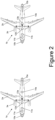
- the detection of the contrails 4a causes the avionics system 17a of the first aircraft 1a to switch its fuel system to the second fuel, by changing from the first fuel tank 12a to the second fuel tank 13a as shown in Figure 2 .
- the consequent switch to SAF fuel causes the contrails 4a to stop as shown in Figure 2 .
- the second aircraft 1b also implements one or more contrail suppression measures on a basis of the data received from the first aircraft in the transmission 16.
- it causes the avionics system 17b of the second aircraft 1b to switch from fuel tank 12b to fuel tank 13b as shown in Figure 2 , so no contrails are generated by the second aircraft 1b when it flies into the air space previously occupied by the first aircraft 1a at the time of Figure 1 .
- the switch from fuel tank 12b to fuel tank 13b may be made immediately, if the aircraft 1a,b are flying in close formation, or at a later time when the second aircraft 1b enters the airspace where the contrails 4a were being generated by the first aircraft.
- the contrail information in the transmission 16 is indicative of an absence of contrails 4a being generated by the first aircraft 1a.
- the first aircraft 1a is about to fly into an ice super saturated region (ISSR) 20 which will tend to cause contrails to be generated, and this is indicated by the atmospheric information in the transmission 16.
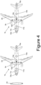
- the detection of the ISSR 20 in the atmospheric information causes the avionics system 17a of the first aircraft 1a to switch from fuel tank 12a to fuel tank 13a as shown in Figure 4 , which prevents contrails from developing as the first aircraft 1a flies into the ISSR 20.
- the second aircraft 1b also implements one or more contrail suppression measures on a basis of the data received from the first aircraft in the transmission 16.
- the avionics system 17b of the second aircraft 1b causes the avionics system 17b of the second aircraft 1b to switch from fuel tank 12b to fuel tank 13b as shown in Figure 4 , so no contrails are generated by the second aircraft 1b when it flies into the ISSR 20.
- the switch from fuel tank 12b to fuel tank 13b may be made immediately, if the aircraft 1a,b are flying in close formation, or at a later time when the second aircraft 1b enters the ISSR 20.
- the avionics system 17a of the first aircraft 1a may switch the fuel system back to fuel tank 12a.
- the second aircraft 1b may also switch its fuel system back to fuel tank 12b on a basis of the atmospheric information from the first aircraft 1a.
- Figures 1-4 show one type of contrail suppression measure (change of fuel type) which can be implemented by the aircraft 1a,b. Another type of contrail suppression measure is to feed a contrail suppression fuel-additive into the fuel line from the first fuel tank 12a,b without switching from JetA1. Another type of contrail suppression measure (change of flight route) is shown in Figures 5 and 6 .
- the aircraft 1a,b are following a flight route 30 which is heading into an ISSR 20.
- the detection of the ISSR 20 causes both aircraft 1a,b to implement a contrail suppression measure, which in this case comprises lowering their cruise altitude to revised flight routes 31, 32 which avoid the ISSR 20, thus avoiding the creation of contrails by either aircraft 1a,b.
- the avionics system 17a of the first aircraft is configured to calculate the revised flight route 31 for the first aircraft 1a on a basis of the atmospheric information; and/or the avionics system 17a of the first aircraft is configured to calculate the revised flight route 32 for the second aircraft 1b on a basis of the atmospheric information.
- a contrail suppression system comprising a sensing system 11a, 14a onboard a first aircraft 1a; and a second aircraft 1b configured to implement one or more contrail suppression measures on a basis of the data.
- a sensing system is provided onboard each aircraft 1a,b but only the sensing system of the first aircraft 1a is used. In an alternative embodiment, only the first aircraft 1a may have such a sensing system.
- the examples above enable contrails to be suppressed in real time by direct aircraft-to-aircraft communication during simultaneous flights of two aircraft.
- the two aircraft may be flying in a coordinated fashion in close formation, or separated by some distance (i.e. not flying in a coordinated fashion or in close formation). Both aircraft are in flight in Figures 1-6 , but in an alternative embodiment the second aircraft 1b may be on the ground when it receives the data from the first aircraft 1a.
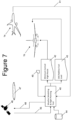
- the alternative example of Figure 7 provides a system for generating a flight route before a flight of the second aircraft 1b, which reduces the generation of contrails during the flight of the second aircraft 1b.
- the system of Figure 7 comprises a computer-implemented ground-based flight planning tool 40 configured to receive atmospheric information and contrail information from the first aircraft 1a via a transmission 41, which may optionally be transmitted via a satellite or other intermediaries.
- the transmission 41 may be received continuously or intermittently during flight of the first aircraft 1a.
- the data in the transmission 41 comprises atmospheric information indicative of an atmospheric condition and/or contrail information indicative of a presence or absence of contrails generated by the first aircraft 1a.
- the flight planning tool 40 is configured to calculate a minimum contrail flight route 42 for the second aircraft 1b on a basis of the data from the first aircraft 1a.
- the minimum contrail flight route 42 comprises a flight route for the second aircraft 1b designed by the flight planning tool 40 with minimal risk of contrail generation, by avoiding ISSRs detected by other aircraft (such as the first aircraft 1a); and/or by avoiding air space in which contrails have recently been generated by other aircraft (such as the first aircraft 1a).
- the flight planning tool 40 is also configured to calculate a risk of contrail generation for the minimum contrail flight route 42; and calculate an SAF/additive load 43 for the second aircraft 1b on a basis of the risk of contrail generation for the minimum contrail flight route 42.
- the SAF/additive load 43 may indicate the volume or mass of SAF fuel which must be loaded into the fuel tank 13b of the second aircraft 1b, to ensure that it contains sufficient SAF fuel to suppress contrail generation to the extent expected as the second aircraft 1b flies the minimum contrail flight route 42. Hence if the minimum contrail flight route 42 has a high risk of contrail generation, then a higher volume of SAF fuel may be required compared to a minimum contrail flight route 42 with a low risk of contrail generation.
- first fuel tank 12b Prior to the second aircraft's next flight, its first fuel tank 12b is loaded with a first fuel (for instance JetA1) and its second fuel tank 13b is loaded with an amount of a second fuel (for instance SAF) less prone to causing contrails than the first fuel.
- the amount of the second fuel loaded into the second fuel tank 13b is determined on a basis of the SAF/additive load 43 calculated by the flight planning tool 40.
- the SAF/additive load 43 may indicate the volume or mass of contrail suppression fuel-additive which must be loaded onto second aircraft 1b, to ensure that it contains sufficient contrail suppression fuel-additive to suppress contrail generation to the extent expected as the second aircraft 1b flies the minimum contrail flight route 42.
- the minimum contrail flight route 42 has a high risk of contrail generation, then a higher volume of contrail suppression fuel-additive may be required compared to a minimum contrail flight route 42 with a low risk of contrail generation.
- the amount of the contrail suppression fuel-additive loaded onto the second aircraft 1b is determined on a basis of the SAF/additive load 43 calculated by the flight planning tool 40.
- the minimum contrail flight route 42 and the SAF/additive load 43 may be calculated by the flight planning tool 40 on a basis of not only the data in the transmission 41 from the first aircraft 1a, but also other data such as: external meteorological information from a geospatial meteorological database 44, and/or satellite observations 45 from a satellite 46 (the satellite observations indicating the presence or absence of ISSRs 47), and/or observations from ground based sensors 49.
- the satellite 46 may be updated by the flight planning tool 40 via a transmission 48 to update new ISSR acquisitions by the satellite 46.
- the minimum contrail flight route 42 and the SAF/additive load 43 are transmitted to the second aircraft 1b on the ground before its flight.
- the minimum contrail flight route 42 may instead be transmitted to the second aircraft 1b during flight of the second aircraft 1b.
- the minimum contrail flight route 42 is stored on the second aircraft 1b, and the second aircraft 1b is then operated to fly the minimum contrail flight route 42.
- inventions 1-7 various methods of contrail suppression are disclosed in Figures 1-7 .
- the methods comprise: generating data with a sensing system 11a, 14a onboard a first aircraft 1a during a flight of the first aircraft, wherein the data comprises atmospheric information indicative of an atmospheric condition and/or contrail information indicative of a presence or absence of contrails generated by the first aircraft; and operating a second aircraft 1b to perform one or more contrail suppression measures on a basis of the data.
- the contrail suppression measure may comprise a flight route (as in Figure 6 ), a switch of fuel composition (as in Figures 2 and 4 ), the use of a contrail suppression additive, or any other measure which has the effect of reducing the generation of contrails by the second aircraft 1b.
- the data is transmitted from the first aircraft 1a during the flight of the first aircraft 1a, although optionally it may be obtained from the first aircraft 1a after the flight of the first aircraft 1a.
- Methods of calculating a flight route comprise: receiving data from a first aircraft 1a during a flight of the first aircraft, wherein the data comprises atmospheric information indicative of an atmospheric condition and/or contrail information indicative of a presence or absence of contrails generated by the first aircraft 1a; and calculating a flight route for a second aircraft 1b on a basis of the data.
- the flight route may be calculated before flight of the second aircraft 1b by a ground-based flight planning tool 40 as shown in Figure 7 , or it may be calculated in real time during flight of the second aircraft 1b by a computer-implemented flight planning tool onboard the second aircraft 1b.
- a computer-implemented flight planning tool configured to receive data from a first aircraft 1a.
- the data comprises atmospheric information indicative of an atmospheric condition and/or contrail information indicative of a presence or absence of contrails generated by the first aircraft 1a.
- the flight planning tool 40 is configured to calculate a flight route for a second aircraft 1b on a basis of the data.
- the flight planning tool may be a ground-based tool 40 as in Figure 7 , or a tool hosted onboard the second aircraft 1b.
- an aircraft 1a comprising a sensing system 11a, 14a.
- the sensing system is configured to generate data, the data comprising atmospheric information indicative of an atmospheric condition and/or contrail information indicative of a presence or absence of contrails generated by the aircraft 1a.
- a transmitter 15a is configured to transmit the data during flight of the aircraft 1a, either via a direct aircraft-to-aircraft transmission 16 as in Figure 1 , or via a transmission 41 to a ground-based flight planning tool 40 as in Figure 7 .
- the provision of a transmitter 15a enables the data to be used not only to trigger the implementation of one or more contrail suppression measures for the first aircraft 1a, but also to trigger the implementation of one or more contrail suppression measures for a second aircraft 1b.
Landscapes
- Engineering & Computer Science (AREA)
- Aviation & Aerospace Engineering (AREA)
- Physics & Mathematics (AREA)
- General Physics & Mathematics (AREA)
- Chemical & Material Sciences (AREA)
- Combustion & Propulsion (AREA)
- Mechanical Engineering (AREA)
- General Engineering & Computer Science (AREA)
- Manufacturing & Machinery (AREA)
- Transportation (AREA)
- Traffic Control Systems (AREA)
- Radar, Positioning & Navigation (AREA)
- Remote Sensing (AREA)
Abstract
A method of contrail suppression. Data is generated with a sensing system onboard a first aircraft during a flight of the first aircraft. The data comprises atmospheric information indicative of an atmospheric condition and/or contrail information indicative of a presence or absence of contrails generated by the first aircraft. A second aircraft is operated to perform one or more contrail suppression measures on a basis of the data.
Description
- The present invention relates to an aircraft, a flight planning tool, a method of contrail suppression, a computer-implemented method of calculating a flight route, a method of fuelling an aircraft, and a method of loading an aircraft with a contrail suppression fuel-additive.
-
EP3961012 A1 discloses an aircraft flight contrail assessment device comprising a contrail sensor adapted to produce contrails data representative of an atmosphere parameter having an influence on the formation of contrails or an observation parameter varying depending on at least the presence of one or more contrails, and a processing unit adapted to calculate at least a contrails value representative of an amount of contrail, based on said contrails data. The invention provides such device as well a corresponding method to evaluate the amount of contrails produced by an aircraft during a flight. - A first aspect of the invention provides a method of contrail suppression, the method comprising: generating data with a sensing system onboard a first aircraft during a flight of the first aircraft, wherein the data comprises atmospheric information indicative of an atmospheric condition and/or contrail information indicative of a presence or absence of contrails generated by the first aircraft; and operating a second aircraft to perform one or more contrail suppression measures on a basis of the data.
- Optionally the data is associated with an air space occupied by the first aircraft during the flight of the first aircraft; and the flight of the second aircraft follows a flight route which includes the air space occupied by the first aircraft.
- Optionally the method further comprises transmitting the data from the first aircraft during the flight of the first aircraft.
- Optionally the method further comprises receiving the data at the second aircraft during the flight of the second aircraft.
- Optionally the one or more contrail suppression measures comprise switching a fuel system of the second aircraft to a fuel less prone to cause contrails.
- Optionally the one or more contrail suppression measures comprise a flight route for the second aircraft.
- A second aspect of the invention provides a computer-implemented method of calculating a flight route, the method comprising: receiving data from a first aircraft during a flight of the first aircraft, wherein the data comprises atmospheric information indicative of an atmospheric condition and/or contrail information indicative of a presence or absence of contrails generated by the first aircraft; and calculating a flight route for a second aircraft on a basis of the data.
- Optionally the flight route is calculated by a flight planning tool.
- Optionally the flight route is calculated on a basis of external meteorological information, and/or on a basis of satellite observation, and/or on a basis of observations from ground based sensors.
- Optionally the method further comprises transmitting the flight route to the second aircraft.
- Optionally the flight route is transmitted to the second aircraft on the ground before its flight.
- Optionally the flight route includes air space occupied by the first aircraft.
- Optionally the flight route is calculated to avoid ice super saturated regions detected by the first aircraft and/or calculated to avoid air space in which contrails have been generated by the first aircraft.
- A further aspect of the invention provides a method of operating an aircraft, the method comprising: calculating a flight route by a method according to the second aspect; and operating the aircraft to fly the flight route.
- A further aspect of the invention provides a method of fuelling an aircraft, the method comprising: calculating a flight route by a method according to the second aspect; calculating a risk of contrail generation for the calculated flight route; calculating a fuel load on a basis of the risk of contrail generation for the flight route; loading the second aircraft with a first fuel; and loading the aircraft with an amount of a second fuel which is less prone to causing contrails than the first fuel, wherein the amount of the second fuel is determined on a basis of the calculated fuel load.
- A further aspect of the invention provides a method of loading an aircraft with a contrail suppression fuel-additive, the method comprising: calculating a flight route by a method according to the second aspect; calculating a risk of contrail generation for the calculated flight route; calculating an additive load on a basis of the risk of contrail generation for the flight route; and loading the aircraft with an amount of a contrail suppression fuel-additive, wherein the amount of the contrail suppression fuel-additive is determined on a basis of the additive load.
- Optionally the data comprises atmospheric information indicative of an atmospheric condition.
- Optionally the data comprises contrail information indicative of a presence or absence of contrails generated by the first aircraft.
- Optionally the data comprises atmospheric information indicative of an atmospheric condition and contrail information indicative of a presence or absence of contrails generated by the first aircraft.
- Optionally the atmospheric condition comprises a humidity.
- Optionally the atmospheric information comprises an indication of an ice super saturated region.
- A further aspect of the invention provides an aircraft comprising: a sensing system, wherein the sensing system is configured to generate data, the data comprising atmospheric information indicative of an atmospheric condition and/or contrail information indicative of a presence or absence of contrails generated by the aircraft; and a transmitter configured to transmit the data during flight of the aircraft.
- Optionally the data comprises atmospheric information indicative of an atmospheric condition and contrail information indicative of a presence or absence of contrails generated by the first aircraft; and the sensing system comprises an atmospheric sensor configured to generate the atmospheric information and a contrail sensor configured to generate the contrail information.
- A further aspect of the invention provides a contrail suppression system comprising: a first aircraft according to the receding aspect; and a second aircraft configured to implement one or more contrail suppression measures on a basis of the data.
- Optionally the system further comprises: a flight planning tool configured to calculate a flight route for the second aircraft on a basis of the data, wherein the second aircraft is configured to follow the flight route.
- Optionally the flight planning tool is configured to transmit the flight route to the second aircraft.
- A further aspect of the invention provides a flight planning tool configured to receive data from a first aircraft, wherein the data comprises atmospheric information indicative of an atmospheric condition and/or contrail information indicative of a presence or absence of contrails generated by the first aircraft, and wherein the flight planning tool is configured to calculate a flight route for a second aircraft on a basis of the data.
- Optionally the flight route is calculated to avoid ice super saturated regions detected by the first aircraft and/or calculated to avoid air space in which contrails have been generated by the first aircraft.
- Optionally the flight planning tool is configured to calculate a risk of contrail generation for the calculated flight route; and the flight planning tool is further configured to calculate a fuel load for the second aircraft on a basis of the risk of contrail generation for the calculated flight route.
- Embodiments of the invention will now be described with reference to the accompanying drawings, in which:
-
Figure 1 shows a contrail suppression system comprising a pair of aircraft -
Figure 2 shows the aircraft implementing a contrail suppression measure of using a fuel is less prone to cause contrails; -
Figure 3 shows the aircraft ofFigure 1 approaching an ice super saturated region; -
Figure 4 shows the aircraft implementing a contrail suppression measure of using a fuel is less prone to cause contrails; -
Figure 5 shows the aircraft flying on a common flight route; -
Figure 6 shows the aircraft implementing a contrail suppression measure of reducing their altitude; and -
Figure 7 shows a system for generating a flight route. -
Figure 1 shows a contrail suppression system comprising first andsecond aircraft 1a,b during flight. Theaircraft 1a,b may be flying in close formation, or separated by some distance but with the second (following)aircraft 1b following the first (leading)aircraft 1a along a similar flight route. Theaircraft 1a,b are similar, with equivalent parts designated 'a' for thefirst aircraft 1a, and 'b' for thesecond aircraft 1b. - Each aircraft comprises a pair of
wings 2a,bcarrying engines 3a,b. Theengines 3a,b are fed with fuel from a fuel system comprisingfuel tanks 12a,b and 13a,b. The engines can either be fed with a first fuel from afirst fuel tank 12a,b or with second fuel from asecond fuel tank 13a,b. At the time ofFigure 1 the engines are being fed with the first fuel from thefirst fuel tank 12a,b. The fuel tanks are only indicated schematically and can be located in any part of the aircraft. - The first fuel may be a standard fuel, such as JetA1, which is likely to cause condensation trails (referred to herein as "contrails") in certain atmospheric conditions. The second fuel may be Sustainable Aviation Fuel (SAF), or any other fuel which is less prone to causing contrails than the first fuel. SAF is less prone to causing contrails than JetA1 because it produces less soot.
- Each aircraft comprises a
transmitter 10a,b configured to transmit data from the aircraft during flight of the aircraft, and areceiver 15a,b configured to receive data at the aircraft during flight of the aircraft. These can be located in any part of the aircraft and are shown in the nose and tail inFigure 1 for ease of illustration. In this example the transmitter and receiver are shown as separate devices, but in other embodiments a single device may be used to provide transmit and receive functions. - Each aircraft comprises an avionics system indicated schematically at 17a,b which controls the
fuel tanks 12a,b; 13a,b and also controls the flight route of the aircraft. Theavionics system 17a,b may be configured to implement one or more contrail suppression measures during a flight of the aircraft. For instance theavionics system 17a,b can switch the fuel system to the second fuel (which is less prone to cause contrails) and operate flight control devices (rudder, ailerons etc) to control the trajectory of the aircraft to follow a flight route less likely to cause contrails. - Each aircraft also comprises a sensing system comprising a forward-facing
atmospheric sensor 11a,b and a rear-facingcontrail sensor 14a,b. - The
atmospheric sensor 11a,b can be located onboard the aircraft at any position in which it has an unimpeded forward-facing view. Theatmospheric sensor 11a,b is configured to generate atmospheric information indicative of an atmospheric condition and feed the atmospheric information to theavionics system 17a,b and thetransmitter 15a,b. By way of non-limiting example, the atmospheric condition may comprise a humidity, or any other indication of an ice super saturated region (ISSR) which will tend to cause contrails to be generated. - The
contrail sensor 14a,b can be located onboard the aircraft at any position in which it has an unimpeded rear-facing view. Thecontrail sensor 14a,b is configured to generate contrail information indicative of a presence or absence of contrails generated by the aircraft and feed the contrail information to theavionics system 17a,b and thetransmitter 15a,b. By way of non-limiting example, thecontrail sensor 14a,b may be a rear-facing camera which takes images of the exhaust plumes of the aircraft and analyses the images to detect the presence or absence of contrails. - Note that each
contrail sensor 14a,b is configured to generate contrail information indicative of a presence or absence of contrails generated by the aircraft carrying the sensor. That is, thecontrail sensor 14a is configured to generate contrail information indicative of a presence or absence ofcontrails 4a generated by thefirst aircraft 1a; and thecontrail sensor 14b is configured to generate contrail information indicative of a presence or absence of contrails generated by thesecond aircraft 1b. - The data from the
sensing system first aircraft 1a during the flight of thefirst aircraft 1a. Specifically, the atmospheric information is indicative of an atmospheric condition in the air space immediately in front of thefirst aircraft 1a (hence soon to be occupied by thefirst aircraft 1a) and the contrail information is indicative of a presence or absence of contrails generated by thefirst aircraft 1a in the air space immediately behind thefirst aircraft 1a. - The atmospheric information and contrail information may be recorded onboard the
aircraft 1a,b. - The flight of the
second aircraft 1b may follow a flight route which includes the air space occupied by thefirst aircraft 1a. - In a
transmission 16 shown inFigure 1 , the atmospheric information and contrail information are transmitted from thetransmitter 15a of thefirst aircraft 1a during flight of thefirst aircraft 1a and received at thereceiver 10b of thesecond aircraft 1b during flight of thesecond aircraft 1b. - At the time of
Figure 1 , the contrail information in thetransmission 16 is indicative of a presence ofcontrails 4a being generated by thefirst aircraft 1a. The detection of thecontrails 4a causes theavionics system 17a of thefirst aircraft 1a to switch its fuel system to the second fuel, by changing from thefirst fuel tank 12a to thesecond fuel tank 13a as shown inFigure 2 . The consequent switch to SAF fuel causes thecontrails 4a to stop as shown inFigure 2 . - The
second aircraft 1b also implements one or more contrail suppression measures on a basis of the data received from the first aircraft in thetransmission 16. In this example, it causes theavionics system 17b of thesecond aircraft 1b to switch fromfuel tank 12b tofuel tank 13b as shown inFigure 2 , so no contrails are generated by thesecond aircraft 1b when it flies into the air space previously occupied by thefirst aircraft 1a at the time ofFigure 1 . The switch fromfuel tank 12b tofuel tank 13b may be made immediately, if theaircraft 1a,b are flying in close formation, or at a later time when thesecond aircraft 1b enters the airspace where thecontrails 4a were being generated by the first aircraft. - At a different time shown in
Figure 3 , no contrails are being generated so the contrail information in thetransmission 16 is indicative of an absence ofcontrails 4a being generated by thefirst aircraft 1a. However, thefirst aircraft 1a is about to fly into an ice super saturated region (ISSR) 20 which will tend to cause contrails to be generated, and this is indicated by the atmospheric information in thetransmission 16. The detection of theISSR 20 in the atmospheric information causes theavionics system 17a of thefirst aircraft 1a to switch fromfuel tank 12a tofuel tank 13a as shown inFigure 4 , which prevents contrails from developing as thefirst aircraft 1a flies into theISSR 20. Thesecond aircraft 1b also implements one or more contrail suppression measures on a basis of the data received from the first aircraft in thetransmission 16. In this example it causes theavionics system 17b of thesecond aircraft 1b to switch fromfuel tank 12b tofuel tank 13b as shown inFigure 4 , so no contrails are generated by thesecond aircraft 1b when it flies into theISSR 20. The switch fromfuel tank 12b tofuel tank 13b may be made immediately, if theaircraft 1a,b are flying in close formation, or at a later time when thesecond aircraft 1b enters theISSR 20. - In the case of
Figure 2 andFigure 4 , when the atmospheric information indicates that thefirst aircraft 1a is no longer flying in an ISSR, then theavionics system 17a of thefirst aircraft 1a may switch the fuel system back tofuel tank 12a. Thesecond aircraft 1b may also switch its fuel system back tofuel tank 12b on a basis of the atmospheric information from thefirst aircraft 1a. -
Figures 1-4 show one type of contrail suppression measure (change of fuel type) which can be implemented by theaircraft 1a,b. Another type of contrail suppression measure is to feed a contrail suppression fuel-additive into the fuel line from thefirst fuel tank 12a,b without switching from JetA1. Another type of contrail suppression measure (change of flight route) is shown inFigures 5 and 6 . - In
Figure 5 theaircraft 1a,b are following aflight route 30 which is heading into anISSR 20. The detection of theISSR 20 causes bothaircraft 1a,b to implement a contrail suppression measure, which in this case comprises lowering their cruise altitude to revisedflight routes ISSR 20, thus avoiding the creation of contrails by eitheraircraft 1a,b. - Optionally the
avionics system 17a of the first aircraft is configured to calculate the revisedflight route 31 for thefirst aircraft 1a on a basis of the atmospheric information; and/or theavionics system 17a of the first aircraft is configured to calculate the revisedflight route 32 for thesecond aircraft 1b on a basis of the atmospheric information. - In the examples above, a contrail suppression system is provided comprising a
sensing system first aircraft 1a; and asecond aircraft 1b configured to implement one or more contrail suppression measures on a basis of the data. In the methods described, a sensing system is provided onboard eachaircraft 1a,b but only the sensing system of thefirst aircraft 1a is used. In an alternative embodiment, only thefirst aircraft 1a may have such a sensing system. - The examples above enable contrails to be suppressed in real time by direct aircraft-to-aircraft communication during simultaneous flights of two aircraft. The two aircraft may be flying in a coordinated fashion in close formation, or separated by some distance (i.e. not flying in a coordinated fashion or in close formation). Both aircraft are in flight in
Figures 1-6 , but in an alternative embodiment thesecond aircraft 1b may be on the ground when it receives the data from thefirst aircraft 1a. - The alternative example of
Figure 7 provides a system for generating a flight route before a flight of thesecond aircraft 1b, which reduces the generation of contrails during the flight of thesecond aircraft 1b. - The system of
Figure 7 comprises a computer-implemented ground-basedflight planning tool 40 configured to receive atmospheric information and contrail information from thefirst aircraft 1a via atransmission 41, which may optionally be transmitted via a satellite or other intermediaries. Thetransmission 41 may be received continuously or intermittently during flight of thefirst aircraft 1a. As in the previous embodiments, the data in thetransmission 41 comprises atmospheric information indicative of an atmospheric condition and/or contrail information indicative of a presence or absence of contrails generated by thefirst aircraft 1a. - The
flight planning tool 40 is configured to calculate a minimumcontrail flight route 42 for thesecond aircraft 1b on a basis of the data from thefirst aircraft 1a. - The minimum
contrail flight route 42 comprises a flight route for thesecond aircraft 1b designed by theflight planning tool 40 with minimal risk of contrail generation, by avoiding ISSRs detected by other aircraft (such as thefirst aircraft 1a); and/or by avoiding air space in which contrails have recently been generated by other aircraft (such as thefirst aircraft 1a). - Optionally the
flight planning tool 40 is also configured to calculate a risk of contrail generation for the minimumcontrail flight route 42; and calculate an SAF/additive load 43 for thesecond aircraft 1b on a basis of the risk of contrail generation for the minimumcontrail flight route 42. - The SAF/
additive load 43 may indicate the volume or mass of SAF fuel which must be loaded into thefuel tank 13b of thesecond aircraft 1b, to ensure that it contains sufficient SAF fuel to suppress contrail generation to the extent expected as thesecond aircraft 1b flies the minimumcontrail flight route 42. Hence if the minimumcontrail flight route 42 has a high risk of contrail generation, then a higher volume of SAF fuel may be required compared to a minimumcontrail flight route 42 with a low risk of contrail generation. - Prior to the second aircraft's next flight, its
first fuel tank 12b is loaded with a first fuel (for instance JetA1) and itssecond fuel tank 13b is loaded with an amount of a second fuel (for instance SAF) less prone to causing contrails than the first fuel. The amount of the second fuel loaded into thesecond fuel tank 13b is determined on a basis of the SAF/additive load 43 calculated by theflight planning tool 40. - Alternatively the SAF/
additive load 43 may indicate the volume or mass of contrail suppression fuel-additive which must be loaded ontosecond aircraft 1b, to ensure that it contains sufficient contrail suppression fuel-additive to suppress contrail generation to the extent expected as thesecond aircraft 1b flies the minimumcontrail flight route 42. Hence if the minimumcontrail flight route 42 has a high risk of contrail generation, then a higher volume of contrail suppression fuel-additive may be required compared to a minimumcontrail flight route 42 with a low risk of contrail generation. - Prior to the second aircraft's next flight, it is loaded with an amount of contrail suppression fuel-additive. In this case the amount of the contrail suppression fuel-additive loaded onto the
second aircraft 1b is determined on a basis of the SAF/additive load 43 calculated by theflight planning tool 40. - The minimum
contrail flight route 42 and the SAF/additive load 43 may be calculated by theflight planning tool 40 on a basis of not only the data in thetransmission 41 from thefirst aircraft 1a, but also other data such as: external meteorological information from a geospatialmeteorological database 44, and/orsatellite observations 45 from a satellite 46 (the satellite observations indicating the presence or absence of ISSRs 47), and/or observations from ground basedsensors 49. - Optionally the
satellite 46 may be updated by theflight planning tool 40 via atransmission 48 to update new ISSR acquisitions by thesatellite 46. - In this example the minimum
contrail flight route 42 and the SAF/additive load 43 are transmitted to thesecond aircraft 1b on the ground before its flight. Optionally the minimumcontrail flight route 42 may instead be transmitted to thesecond aircraft 1b during flight of thesecond aircraft 1b. - The minimum
contrail flight route 42 is stored on thesecond aircraft 1b, and thesecond aircraft 1b is then operated to fly the minimumcontrail flight route 42. - In summary, various methods of contrail suppression are disclosed in
Figures 1-7 . The methods comprise: generating data with asensing system first aircraft 1a during a flight of the first aircraft, wherein the data comprises atmospheric information indicative of an atmospheric condition and/or contrail information indicative of a presence or absence of contrails generated by the first aircraft; and operating asecond aircraft 1b to perform one or more contrail suppression measures on a basis of the data. The contrail suppression measure may comprise a flight route (as inFigure 6 ), a switch of fuel composition (as inFigures 2 and4 ), the use of a contrail suppression additive, or any other measure which has the effect of reducing the generation of contrails by thesecond aircraft 1b. - Typically the data is transmitted from the
first aircraft 1a during the flight of thefirst aircraft 1a, although optionally it may be obtained from thefirst aircraft 1a after the flight of thefirst aircraft 1a. - Methods of calculating a flight route are also disclosed. The methods comprise: receiving data from a
first aircraft 1a during a flight of the first aircraft, wherein the data comprises atmospheric information indicative of an atmospheric condition and/or contrail information indicative of a presence or absence of contrails generated by thefirst aircraft 1a; and calculating a flight route for asecond aircraft 1b on a basis of the data. The flight route may be calculated before flight of thesecond aircraft 1b by a ground-basedflight planning tool 40 as shown inFigure 7 , or it may be calculated in real time during flight of thesecond aircraft 1b by a computer-implemented flight planning tool onboard thesecond aircraft 1b. - Also disclosed is a computer-implemented flight planning tool configured to receive data from a
first aircraft 1a. The data comprises atmospheric information indicative of an atmospheric condition and/or contrail information indicative of a presence or absence of contrails generated by thefirst aircraft 1a. Theflight planning tool 40 is configured to calculate a flight route for asecond aircraft 1b on a basis of the data. The flight planning tool may be a ground-basedtool 40 as inFigure 7 , or a tool hosted onboard thesecond aircraft 1b. - Also disclosed is an
aircraft 1a comprising asensing system aircraft 1a. Atransmitter 15a is configured to transmit the data during flight of theaircraft 1a, either via a direct aircraft-to-aircraft transmission 16 as inFigure 1 , or via atransmission 41 to a ground-basedflight planning tool 40 as inFigure 7 . The provision of atransmitter 15a enables the data to be used not only to trigger the implementation of one or more contrail suppression measures for thefirst aircraft 1a, but also to trigger the implementation of one or more contrail suppression measures for asecond aircraft 1b. - Where the word 'or' appears this is to be construed to mean 'and/or' such that items referred to are not necessarily mutually exclusive and may be used in any appropriate combination.
- Although the invention has been described above with reference to one or more preferred embodiments, it will be appreciated that various changes or modifications may be made without departing from the scope of the invention as defined in the appended claims.
Claims (15)
- A method of contrail suppression, the method comprising: generating data with a sensing system onboard a first aircraft (1a) during a flight of the first aircraft, wherein the data comprises atmospheric information indicative of an atmospheric condition and/or contrail information indicative of a presence or absence of contrails generated by the first aircraft (1a); and operating a second aircraft (1b) to perform one or more contrail suppression measures on a basis of the data.
- A method according to claim 1, wherein the data is associated with an air space occupied by the first aircraft (1a) during the flight of the first aircraft; and the flight of the second aircraft (1b) follows a flight route (32) which includes the air space occupied by the first aircraft.
- A method according to any preceding claim, further comprising transmitting the data from the first aircraft (1a) during the flight of the first aircraft.
- A method according to any preceding claim, further comprising receiving the data at the second aircraft (1b) during the flight of the second aircraft.
- A method according to any preceding claim, wherein the one or more contrail suppression measures comprise switching a fuel system (12b, 13b) of the second aircraft to a fuel less prone to cause contrails.
- A computer-implemented method of calculating a flight route, the method comprising: receiving data from a first aircraft (1a) during a flight of the first aircraft, wherein the data comprises atmospheric information indicative of an atmospheric condition and/or contrail information indicative of a presence or absence of contrails generated by the first aircraft; and calculating a flight route for a second aircraft (1b) on a basis of the data, wherein the flight route is calculated to avoid ice super saturated regions (20) detected by the first aircraft and/or calculated to avoid air space in which contrails (4a) have been generated by the first aircraft.
- A method of operating an aircraft (1b), the method comprising: calculating a flight route by a method according to claim 6; and operating the aircraft to fly the flight route.
- A method of fuelling an aircraft, the method comprising: receiving data from a first aircraft (1a) during a flight of the first aircraft, wherein the data comprises atmospheric information indicative of an atmospheric condition and/or contrail information indicative of a presence or absence of contrails generated by the first aircraft; calculating a flight route for a second aircraft (1b) on a basis of the data; calculating a risk of contrail generation for the calculated flight route; calculating a fuel load on a basis of the risk of contrail generation for the flight route; loading the second aircraft (1b) with a first fuel; and loading the aircraft (1b) with an amount of a second fuel which is less prone to causing contrails than the first fuel, wherein the amount of the second fuel is determined on a basis of the calculated fuel load.
- A method of loading an aircraft with a contrail suppression fuel-additive, the method comprising: receiving data from a first aircraft (1a) during a flight of the first aircraft, wherein the data comprises atmospheric information indicative of an atmospheric condition and/or contrail information indicative of a presence or absence of contrails generated by the first aircraft; calculating a flight route for a second aircraft (1b) on a basis of the data; calculating a risk of contrail generation for the calculated flight route; calculating an additive load on a basis of the risk of contrail generation for the flight route; and loading the second aircraft (1b) with an amount of a contrail suppression fuel-additive, wherein the amount of the contrail suppression fuel-additive is determined on a basis of the additive load.
- A method according to any preceding claim, wherein the data comprises atmospheric information indicative of an atmospheric condition and contrail information indicative of a presence or absence of contrails (4a) generated by the first aircraft.
- An aircraft (1a) comprising: a sensing system (15a), wherein the sensing system is configured to generate data, the data comprising contrail information indicative of a presence or absence of contrails generated by the aircraft; and a transmitter (10a) configured to transmit the data during flight of the aircraft.
- An aircraft according to claim 11, wherein the data comprises atmospheric information indicative of an atmospheric condition and contrail information indicative of a presence or absence of contrails generated by the first aircraft; and the sensing system comprises an atmospheric sensor configured to generate the atmospheric information and a contrail sensor configured to generate the contrail information.
- A contrail suppression system comprising: a first aircraft (1a) according to claim 11 or 12; and a second aircraft (1b) configured to implement one or more contrail suppression measures on a basis of the data.
- A contrail suppression system according to claim 13, further comprising: a flight planning tool (40) configured to calculate a flight route for the second aircraft on a basis of the data, wherein the second aircraft is configured to follow the flight route.
- A flight planning tool (40) configured to receive data from a first aircraft (1a), wherein the data comprises atmospheric information indicative of an atmospheric condition and/or contrail information indicative of a presence or absence of contrails generated by the first aircraft, and wherein the flight planning tool (40) is configured to calculate a flight route for a second aircraft (1b) on a basis of the data, wherein the flight route is calculated to avoid ice super saturated regions (20) detected by the first aircraft and/or calculated to avoid air space in which contrails (4a) have been generated by the first aircraft (1a).
Applications Claiming Priority (1)
| Application Number | Priority Date | Filing Date | Title |
|---|---|---|---|
| GB2301420.2A GB2626923A (en) | 2023-02-01 | 2023-02-01 | Contrail suppression |
Publications (1)
| Publication Number | Publication Date |
|---|---|
| EP4418237A1 true EP4418237A1 (en) | 2024-08-21 |
Family
ID=85476455
Family Applications (1)
| Application Number | Title | Priority Date | Filing Date |
|---|---|---|---|
| EP24152043.6A Pending EP4418237A1 (en) | 2023-02-01 | 2024-01-16 | Contrail suppression |
Country Status (4)
| Country | Link |
|---|---|
| US (1) | US12505750B2 (en) |
| EP (1) | EP4418237A1 (en) |
| CN (1) | CN118426480A (en) |
| GB (1) | GB2626923A (en) |
Families Citing this family (2)
| Publication number | Priority date | Publication date | Assignee | Title |
|---|---|---|---|---|
| US12555484B2 (en) * | 2023-08-29 | 2026-02-17 | Honeywell International Inc. | Systems and methods for diminishing vehicle contrails |
| US20250201135A1 (en) * | 2023-12-13 | 2025-06-19 | Honeywell International Inc. | Monitoring for conditions likely to cause persistent contrails |
Citations (4)
| Publication number | Priority date | Publication date | Assignee | Title |
|---|---|---|---|---|
| EP2860375A1 (en) * | 2013-10-08 | 2015-04-15 | Rolls-Royce plc | Aircraft engine fuel system |
| US9824593B1 (en) * | 2015-09-21 | 2017-11-21 | Rockwell Collins, Inc. | System and method for holistic flight and route management |
| EP3961012A1 (en) | 2020-09-01 | 2022-03-02 | Airbus Operations, S.L.U. | Aircraft flight contrail assessment device and method |
| US20220223052A1 (en) * | 2019-05-23 | 2022-07-14 | Smartsky Networks LLC | Augmented Reality in Aircraft Cockpit Through Bi-Directional Connectivity |
Family Cites Families (6)
| Publication number | Priority date | Publication date | Assignee | Title |
|---|---|---|---|---|
| GB201405894D0 (en) | 2014-04-02 | 2014-05-14 | Rolls Royce Plc | Aircraft vapour trail control system |
| GB201420989D0 (en) | 2014-11-26 | 2015-01-07 | Rolls Royce Plc | Aircraft engine fuel system |
| CN111610793A (en) * | 2019-02-26 | 2020-09-01 | 北京京东尚科信息技术有限公司 | A kind of artificial rainfall method and device |
| EP3875741A1 (en) * | 2020-03-04 | 2021-09-08 | Rolls-Royce plc | Gas turbine engine with water injection |
| GB2599918B (en) | 2020-10-13 | 2023-03-29 | Durant Adam | Methods for optimising the atmospheric radiative forcing of aircraft flight operations on climate by forecasting and validating aircraft contrail formation |
| GB202205358D0 (en) * | 2022-04-12 | 2022-05-25 | Rolls Royce Plc | Loading parameters |
-
2023
- 2023-02-01 GB GB2301420.2A patent/GB2626923A/en active Pending
-
2024
- 2024-01-16 EP EP24152043.6A patent/EP4418237A1/en active Pending
- 2024-01-30 CN CN202410134586.4A patent/CN118426480A/en active Pending
- 2024-01-31 US US18/428,815 patent/US12505750B2/en active Active
Patent Citations (4)
| Publication number | Priority date | Publication date | Assignee | Title |
|---|---|---|---|---|
| EP2860375A1 (en) * | 2013-10-08 | 2015-04-15 | Rolls-Royce plc | Aircraft engine fuel system |
| US9824593B1 (en) * | 2015-09-21 | 2017-11-21 | Rockwell Collins, Inc. | System and method for holistic flight and route management |
| US20220223052A1 (en) * | 2019-05-23 | 2022-07-14 | Smartsky Networks LLC | Augmented Reality in Aircraft Cockpit Through Bi-Directional Connectivity |
| EP3961012A1 (en) | 2020-09-01 | 2022-03-02 | Airbus Operations, S.L.U. | Aircraft flight contrail assessment device and method |
Non-Patent Citations (1)
| Title |
|---|
| SHERRY LANCE ET AL: "Design of an Aircraft Induced Cloud (AIC) Abatement Program (AAP) for Global Warming Mitigation", 2021 INTEGRATED COMMUNICATIONS NAVIGATION AND SURVEILLANCE CONFERENCE (ICNS), IEEE, 19 April 2021 (2021-04-19), pages 1 - 10, XP033920846, DOI: 10.1109/ICNS52807.2021.9441627 * |
Also Published As
| Publication number | Publication date |
|---|---|
| US20240257653A1 (en) | 2024-08-01 |
| GB202301420D0 (en) | 2023-03-15 |
| US12505750B2 (en) | 2025-12-23 |
| GB2626923A (en) | 2024-08-14 |
| CN118426480A (en) | 2024-08-02 |
Similar Documents
| Publication | Publication Date | Title |
|---|---|---|
| EP4418237A1 (en) | Contrail suppression | |
| US11335204B2 (en) | Flight path deconfliction among unmanned aerial vehicles | |
| CA2998342C (en) | System and method for optimization of aircraft fuel economy in real-time | |
| US8788188B1 (en) | Dynamic weather selection | |
| US8774989B1 (en) | Aircraft energy state display | |
| US8386097B2 (en) | Method and device to assist in the guidance of an airplane | |
| US8014907B2 (en) | Method of assisting in the navigation of an aircraft with an updating of the flight plan | |
| US10024665B2 (en) | Environmental waypoint insertion | |
| US8532848B2 (en) | Systems and methods for alerting potential tailstrike during landing | |
| US8005583B2 (en) | Method and device for determining the air turbulence likely to be encountered by an aircraft | |
| US20220380048A1 (en) | Recording data associated with an unmanned aerial vehicle | |
| US11676498B2 (en) | Enhanced vehicle efficiency through smart automation for on-board weather update | |
| US20110071710A1 (en) | Method and device for detecting an erroneous speed generated by an air data inertial reference system | |
| US20220383762A1 (en) | Increasing awareness of an environmental condition for an unmanned aerial vehicle | |
| US20080035784A1 (en) | Aircraft wake vortex predictor and visualizer | |
| US8935016B2 (en) | Method and device for automatically managing the spacing of at least one following aircraft behind at least one target aircraft | |
| WO2021046021A1 (en) | Determining whether to service an unmanned aerial vehicle | |
| GB2529271A (en) | Meteorological hazard identification apparatus, moving craft and methods | |
| CN111066074A (en) | Aeronautical weather control system | |
| US20220351626A1 (en) | Multi-objective mission planning and execution for an unmanned aerial vehicle | |
| EP4330946A1 (en) | Unmanned aerial vehicle response to object detection | |
| US20050273221A1 (en) | Flight control indicator determining the maximum slope for the flight control of an aircraft by terrain following | |
| US20220058967A1 (en) | Sensor enhanced real time automatic pilot report (pirep) generation | |
| EP3719776A1 (en) | Emulating a vehicle-communications-center data request to obtain data from a system or subsystem onboard the vehicle | |
| US12612877B2 (en) | Contrail suppression |
Legal Events
| Date | Code | Title | Description |
|---|---|---|---|
| PUAI | Public reference made under article 153(3) epc to a published international application that has entered the european phase |
Free format text: ORIGINAL CODE: 0009012 |
|
| STAA | Information on the status of an ep patent application or granted ep patent |
Free format text: STATUS: THE APPLICATION HAS BEEN PUBLISHED |
|
| AK | Designated contracting states |
Kind code of ref document: A1 Designated state(s): AL AT BE BG CH CY CZ DE DK EE ES FI FR GB GR HR HU IE IS IT LI LT LU LV MC ME MK MT NL NO PL PT RO RS SE SI SK SM TR |
|
| STAA | Information on the status of an ep patent application or granted ep patent |
Free format text: STATUS: REQUEST FOR EXAMINATION WAS MADE |
|
| 17P | Request for examination filed |
Effective date: 20250205 |