EP4343477A1 - System for cutting grass and corresponding process - Google Patents
System for cutting grass and corresponding process Download PDFInfo
- Publication number
- EP4343477A1 EP4343477A1 EP23198046.7A EP23198046A EP4343477A1 EP 4343477 A1 EP4343477 A1 EP 4343477A1 EP 23198046 A EP23198046 A EP 23198046A EP 4343477 A1 EP4343477 A1 EP 4343477A1
- Authority
- EP
- European Patent Office
- Prior art keywords
- gnss
- gps
- antenna
- robot
- information
- Prior art date
- Legal status (The legal status is an assumption and is not a legal conclusion. Google has not performed a legal analysis and makes no representation as to the accuracy of the status listed.)
- Pending
Links
- 238000005520 cutting process Methods 0.000 title claims description 39
- 244000025254 Cannabis sativa Species 0.000 title claims description 18
- 238000000034 method Methods 0.000 title claims description 13
- 230000008569 process Effects 0.000 title description 3
- 238000004891 communication Methods 0.000 claims abstract description 55
- 238000012937 correction Methods 0.000 claims description 37
- 238000012545 processing Methods 0.000 claims description 18
- 230000007257 malfunction Effects 0.000 claims description 7
- 238000001514 detection method Methods 0.000 claims description 4
- 238000010295 mobile communication Methods 0.000 claims 1
- 230000004807 localization Effects 0.000 description 4
- 230000000694 effects Effects 0.000 description 2
- 238000005516 engineering process Methods 0.000 description 2
- 238000009434 installation Methods 0.000 description 2
- 241000196324 Embryophyta Species 0.000 description 1
- 230000008859 change Effects 0.000 description 1
- 230000006870 function Effects 0.000 description 1
- 238000010413 gardening Methods 0.000 description 1
- 238000012423 maintenance Methods 0.000 description 1
- 238000013507 mapping Methods 0.000 description 1
- 238000007620 mathematical function Methods 0.000 description 1
- 238000005259 measurement Methods 0.000 description 1
- 230000009467 reduction Effects 0.000 description 1
Images

Classifications
-
- G—PHYSICS
- G01—MEASURING; TESTING
- G01S—RADIO DIRECTION-FINDING; RADIO NAVIGATION; DETERMINING DISTANCE OR VELOCITY BY USE OF RADIO WAVES; LOCATING OR PRESENCE-DETECTING BY USE OF THE REFLECTION OR RERADIATION OF RADIO WAVES; ANALOGOUS ARRANGEMENTS USING OTHER WAVES
- G01S19/00—Satellite radio beacon positioning systems; Determining position, velocity or attitude using signals transmitted by such systems
- G01S19/01—Satellite radio beacon positioning systems transmitting time-stamped messages, e.g. GPS [Global Positioning System], GLONASS [Global Orbiting Navigation Satellite System] or GALILEO
- G01S19/03—Cooperating elements; Interaction or communication between different cooperating elements or between cooperating elements and receivers
- G01S19/07—Cooperating elements; Interaction or communication between different cooperating elements or between cooperating elements and receivers providing data for correcting measured positioning data, e.g. DGPS [differential GPS] or ionosphere corrections
- G01S19/071—DGPS corrections
-
- G—PHYSICS
- G05—CONTROLLING; REGULATING
- G05D—SYSTEMS FOR CONTROLLING OR REGULATING NON-ELECTRIC VARIABLES
- G05D1/00—Control of position, course or altitude of land, water, air, or space vehicles, e.g. automatic pilot
- G05D1/02—Control of position or course in two dimensions
- G05D1/021—Control of position or course in two dimensions specially adapted to land vehicles
- G05D1/0276—Control of position or course in two dimensions specially adapted to land vehicles using signals provided by a source external to the vehicle
- G05D1/0278—Control of position or course in two dimensions specially adapted to land vehicles using signals provided by a source external to the vehicle using satellite positioning signals, e.g. GPS
-
- A—HUMAN NECESSITIES
- A01—AGRICULTURE; FORESTRY; ANIMAL HUSBANDRY; HUNTING; TRAPPING; FISHING
- A01D—HARVESTING; MOWING
- A01D34/00—Mowers; Mowing apparatus of harvesters
- A01D34/006—Control or measuring arrangements
- A01D34/008—Control or measuring arrangements for automated or remotely controlled operation
-
- G—PHYSICS
- G05—CONTROLLING; REGULATING
- G05D—SYSTEMS FOR CONTROLLING OR REGULATING NON-ELECTRIC VARIABLES
- G05D1/00—Control of position, course or altitude of land, water, air, or space vehicles, e.g. automatic pilot
- G05D1/02—Control of position or course in two dimensions
- G05D1/021—Control of position or course in two dimensions specially adapted to land vehicles
- G05D1/0276—Control of position or course in two dimensions specially adapted to land vehicles using signals provided by a source external to the vehicle
- G05D1/028—Control of position or course in two dimensions specially adapted to land vehicles using signals provided by a source external to the vehicle using a RF signal
- G05D1/0282—Control of position or course in two dimensions specially adapted to land vehicles using signals provided by a source external to the vehicle using a RF signal generated in a local control room
-
- A—HUMAN NECESSITIES
- A01—AGRICULTURE; FORESTRY; ANIMAL HUSBANDRY; HUNTING; TRAPPING; FISHING
- A01D—HARVESTING; MOWING
- A01D2101/00—Lawn-mowers
-
- G—PHYSICS
- G01—MEASURING; TESTING
- G01S—RADIO DIRECTION-FINDING; RADIO NAVIGATION; DETERMINING DISTANCE OR VELOCITY BY USE OF RADIO WAVES; LOCATING OR PRESENCE-DETECTING BY USE OF THE REFLECTION OR RERADIATION OF RADIO WAVES; ANALOGOUS ARRANGEMENTS USING OTHER WAVES
- G01S19/00—Satellite radio beacon positioning systems; Determining position, velocity or attitude using signals transmitted by such systems
- G01S19/01—Satellite radio beacon positioning systems transmitting time-stamped messages, e.g. GPS [Global Positioning System], GLONASS [Global Orbiting Navigation Satellite System] or GALILEO
- G01S19/03—Cooperating elements; Interaction or communication between different cooperating elements or between cooperating elements and receivers
- G01S19/04—Cooperating elements; Interaction or communication between different cooperating elements or between cooperating elements and receivers providing carrier phase data
-
- G—PHYSICS
- G01—MEASURING; TESTING
- G01S—RADIO DIRECTION-FINDING; RADIO NAVIGATION; DETERMINING DISTANCE OR VELOCITY BY USE OF RADIO WAVES; LOCATING OR PRESENCE-DETECTING BY USE OF THE REFLECTION OR RERADIATION OF RADIO WAVES; ANALOGOUS ARRANGEMENTS USING OTHER WAVES
- G01S19/00—Satellite radio beacon positioning systems; Determining position, velocity or attitude using signals transmitted by such systems
- G01S19/38—Determining a navigation solution using signals transmitted by a satellite radio beacon positioning system
- G01S19/39—Determining a navigation solution using signals transmitted by a satellite radio beacon positioning system the satellite radio beacon positioning system transmitting time-stamped messages, e.g. GPS [Global Positioning System], GLONASS [Global Orbiting Navigation Satellite System] or GALILEO
- G01S19/40—Correcting position, velocity or attitude
- G01S19/41—Differential correction, e.g. DGPS [differential GPS]
Definitions
- This invention relates to the technical sector of automatic gardening devices, in particular lawn mower devices.
- the lawn mower devices are used to keep lawns, gardens and grassy areas in general in optimum conditions, that is to say, for keeping the grass below a certain height in a substantially homogeneous manner over the entire cutting area.
- Lawn mower robots of known type generally comprise a load-bearing frame, often having an outer body, to which are associated cutting means for the maintenance of the lawn and robot movement means for moving the robot inside a working area.
- the technical purpose which forms the basis of the invention is to provide a system for cutting grass and a corresponding process which is particularly reliable and effective, and is able to operate in any condition.
- the aim of the invention is to provide grass cutting system and a corresponding process which is simple, reliable and particularly flexible, that is to say, which can be used effectively in the most diverse operating conditions.
- the invention describes a lawn mower system 100, characterised in that it comprises, in combination:
- the remote server 200 is defined by a remote processor, connectable to a network, preferably the Internet, by means of a connecting device 202.
- the database 201 is a memory, of the concentrated type (that is, present in a single processor) or distributed type (cloud).
- connection between the database 201 and the remote processor may be performed through the Internet, using the connecting device 202, or the database 201 may be integrated in the remote server 200.
- the system 100 further comprises a lawn mower robot 1 comprising:
- the remote server 200 is configured for sending to the communication device 11 of the robot 1 GPS correction information of the GPS position of the robot 1 derived from the information received from the GNSS satellites from the GNSS receiving device 21 of said GNSS antenna 20 and/or present in the database 201 for said GNSS antenna 20.
- Said processing module 7 is configured for calculating, on the basis of the GPS correction information and the GPS coordinates of the GPS position of the robot 1 received from the GNSS receiving device 4 of the RTK type, a correct GPS position of the robot 1, according to a differential GPS positioning technique.
- the correct GPS position is particularly accurate.
- the antenna 20A, 20B, 20C sends the first GPS information, also comprising the relative GPS position towards a single point (the remote server 200) and it is the remote server 200 which activates the data flow (regarding the GPS correction information) towards the robot 1, on request.
- the data (correction information) from the remote server 200 towards the communication device 11 of the robot 1 are sent.
- GPS correction information is used to mean a plurality of data which may comprise at least a portion of the first GPS information I1 and/or the information present in the database 201.
- the "GPS correction information" may include GPS positions of antenna 20A.
- the "GPS correction information" may include GNSS satellite identification information whose first information was received by the antenna 20A.
- the correction derived by the robot 1 using the first GPS information I1 of the antenna 20A is an optimum correction also for the robot 1, that is to say, which can be applied to the GPS position of the robot 1, improving the accuracy of the GPS position acquired by the GNSS receiving device 4 of the RTK type.
- the correct GPS position can be used by the processing module 7 to allow a particularly reliable movement.
- the robot 1 comprises a frame 10 for supporting the components of the robot 1.
- the robot 1 comprises grass cutting means 2, coupled to the supporting frame 10, configured to perform an operation for cutting grass inside a cutting zone A.
- the cutting zone A may be, for example, a garden, a park or in general a lawn.
- the grass cutting means 2 face towards the grass and comprise grass cutting elements, for example, one or more blades.
- the cutting means 2 comprise an actuator, not illustrated in the accompanying drawings, configured for moving said grass cutting elements.
- the robot 1 comprises movement means 3, coupled to the supporting frame 10, configured for moving the robot 1.
- the GNSS receiving device 4 of the RTK type is configured to derive coordinates regarding a GPS position of the robot 1.
- a GPS type device 4 which uses RTK technology, that is to say, measurements of satellite data with respect to a fixed ground station (antenna 20A), makes it possible to obtain information with a greater degree of precision compared with the standard GPS systems.
- the term “coupled” means that the communication device 11 and the GPS type device 4 are connected to, and in communication with, the processing module 7.
- the movement means 3 are configured for moving the robot 1 along a feed direction X.
- the movement means 3 comprise a plurality of wheels 3A.
- at least one wheel 3A is a drive wheel and the movement means 3 comprise a rotation motor (not illustrated), operatively connected to said at least one drive wheel.
- At least one wheel 3A is a wheel which can be oriented, that is to say, a wheel which is able to rotate about a substantially vertical axis of rotation, and the movement means 3 comprise an orientation motor (not illustrated) operatively connected to said at least one wheel which can be oriented.
- the drive wheels allow the forward movement along the feed direction, whilst the adjustable wheels change the feed direction when necessary (for example, when obstacles are detected along the working trajectory or the edges of the area to be maintained are reached).
- the power supply of the robot 1, both with regard to the movement means 3 and the cutting means 2 may be performed by electric motors, powered by a battery; the latter may be of the rechargeable type (not illustrated).
- the battery may also power other electrical/electronic devices provided on the lawn mower robot 1.
- the processing module 7 is configured for controlling the movement means 3 of the GPS coordinates stored in the storage unit 8 (and of a trajectory stored in the processing module 7 or received, for example received from the remote server 201).
- the at least one GNSS antenna 20A comprises a plurality of antennas 20A, 20B, 20C, each equipped with a GNSS receiving device 21 designed to receive signals from GNSS satellites (first GPS information) for deriving GPS coordinates of the position of said GNSS antenna 20A, 20B, 20C and of a communication device 22 configured to establish a data connection with a telecommunication network, preferably with the Internet, for transmitting, at predetermined intervals, the GPS coordinates of the position of said antenna 20A, 20B, 20C GNSS, derived from the GNSS receiving device 21, to said remote server 200.
- the remote server 200 is configured for storing the coordinates of the GPS position of said GNSS antennas 20A, 20B, 20C in the database 201.
- the remote server 200 is configured for storing a part of the first GPS information I1 of said GNSS antennas 20A, 20B, 20C in the database 201.
- the fact of having several antennas 20A, 20B, 20C GNSS allows larger areas to be covered, that is to say, the robot can also be taken to areas geographically distant from each other and be able to operate correctly, that is to say, the correct GPS position can be calculated in a particularly reliable manner even over a large geographical area.
- the correct GPS position being particularly reliable, allows the robot 1 to operate in any condition, for example even in the presence of obstacles or in zones which can degrade the quality of the GPS signal received from the robot 1.
- the correct GPS position calculated by the processing module 7, allows the robot 1 to operate in a particularly reliable manner.
- the correct GPS position is the basis for moving the robot 1 (the more accurate is the GPS position derived from the processing module 7 the greater is the precision in cutting and managing the obstacles by the robot 1).
- the remote server 200 is configured for:
- the antenna 20A closest to the position of the robot is used to calculate the correct GPS position.
- the correction applied by the robot 1 is optimum for improving the accuracy: in effect, the closest antenna 20A is in all probability the antenna the correction for which, compared with the others, is better for the robot 1 (in particular for the GPS position where the robot 1 is located).
- the remote server 100 is configured for detecting a malfunction of the antenna 20A.
- the remote server 200 is configured to determine, by means of said comparison, a further second GNSS antenna 20B having, among said GPS antennas 20A, 20B, 20C excluding the first antenna 20A, the smaller distance relative to the localisation position in which the robot 1 is positioned.
- the correction which is sent the communication device 11 of the robot 1 from the remote server 200 in the case of a malfunction of the antenna at the least distance corresponds to that of the second closest active antenna (since the first antenna is malfunctioning, the correction of the second antenna is sent in order of distance).
- the system 1 is able to manage in an effective manner the operation of the robot 1, even in the case of a malfunction of one or more antennas.
- the communication device 22 is configured for transmitting, at predetermined intervals, identification information of the GNSS satellites whose GPS signals have been received from the GNSS receiving device 21 and wherein the processing module 7 is configured for transmitting to the remote server 200 identification information of the GNSS satellites whose GPS signals have been received from the GNSS receiving device 4 of the RTK type.
- the remote server 200 receives the list of the GNSS satellites which can be received by the robot 1 and the list of the GNSS satellites which can be received by each antenna 20A, 20B, 20C, where "which can be received” means the fact that the signal of that satellite is received (preferably within a certain power level).
- the list of GNSS satellites which can be received by the robot 1 and/or the list of GNSS satellites which can be received by each antenna 20A, 20B, 20C are stored in the database 201.
- the remote server 200 is configured for:
- the correction of the GPS position which is sent by the remote server 200 to the communication device 11 of the robot 1 corresponds to the antenna 20A which has more GNSS satellites which can be received in common with those which can be received by the robot 1, where "which can be received” means the fact that the signal of that GNSS satellite is received (preferably within a certain power level).
- the fact that the antenna 20A which is used for the correction has the greatest number of satellites which can be received in common with the robot means that the correction is appropriate and accurate for the robot 1, since it is derived from the same or substantially the same set of GNSS satellites.
- the remote server 200 is configured to determine, by means of said comparison, a further second GNSS antenna 20B having, between said GPS antennas 20A, 20B, 20C excluding the above-mentioned first antenna 20A, the greatest number of GNSS satellites in common with the GNSS satellites whose signals have been received from the RTK type GNSS receiving device 4.
- the communication device 11 of the robot 1 and/or the communication device 22 of the antenna 20 comprises a wireless communication module.
- the communication device 11 of the robot 1 and/or the communication device 22 of the antenna 20 comprises a 4G mobile type communication module.
- the communication device 11 of the robot 1 and/or the communication device 22 of the antenna 20 comprises a mobile GPRS telephone device, configured to be able to exchange data traffic.
- said antennas 20A, 20B, 20C GNSS are positioned, relative to said robot 1, at a predetermined distance of less than 30 km, even more preferably less than 20 km.
- the optimum condition of coverage can be obtained by applying antennas 20A, 20B, 20C trying to cover the territory in such a way that from each point (in which the robot 1 could operate) there is an antenna 20A, 20B, 20C within the predetermined distance.
- the remote server 200 is configured for sending to the communication device 11 of the robot 1 a trajectory to be followed for cutting a cutting zone.
- the processing module 7 of the robot 1 is configured for controlling the movement means 3 of the lawn mower robot 1 on the basis of said trajectory and the correct GPS position.
- the remote server 200 comprises a memory 203 in which trajectories are present, in association with predetermined robots 1.
- the remote server 200 transmits movement information to the processing module 7, which is used by the processing module 7 together with the correct GPS position to control the movement means 3 and cut the cutting area A.
- antenna 20A and/or plurality of antennas 20A, 20B, 20C are described below in more detail.
- the "real" position of the antenna is stored in the database 201, where the term "real" position means a position calculated with a plurality of modes and therefore considered particularly reliable.
- This "real" position of the antenna 20A may define, together with other data, the above-mentioned correction information.
- the installer may use a combination of techniques for deriving the "real" position of the antenna.
- the "real" position is used in combination with the first GPS information I1 derived from the GNSS satellites for calculating the correct GPS position of the robot 1.
- the real position of the antenna 20A is calculated by acquiring first GPS information I1 in a predetermined time interval. This time interval is sufficiently large to allow the antenna 20A to receive the first GPS information from the GNSS satellites, and consequently calculate the GPS coordinates, using a plurality of GNSS satellites and/or with the same set of GNSS satellites in different positions of the sky.
- the real position of the antenna 20A is a mathematical function of a plurality of GPS positions acquired over time.
- the real GPS position of the antenna 20A is an average of these positions, over time.
- the real position for a specific antenna 20A is preferably stored in the database 201 in association with the antenna 20A itself.
- the correction information sent by the remote server 201 to the communication device 11 of the robot 1, preferably comprises the real position.
- correction information also comprises at least a part (or all) of the first GNSS information of a specific selected antenna.
- the communication device 11 of the robot 1 sends the GPS position of the robot 1 to the remote server 201 only at predetermined operating steps, for example at the start of the working phase, that is to say, at the start of the cut or when about to start the cut.
- the communication device 11 of the robot 1 sends the GPS position of the robot 1 to the remote server 201 at predetermined time intervals, preferably less than 20 seconds, even more preferably less than 10 seconds, most preferably less than 5 seconds.
- said time intervals correspond to a second.
- the remote server 201 sends the correction information to the communication device 11 of the robot 1 at predetermined time intervals, preferably less than 20 seconds, even more preferably less than 10 seconds, most preferably less than 5 seconds.
- the invention relates to a cutting process of a cutting zone A.
- the cutting process comprises the following steps:
- the step of preparing a cutting system 100 comprises a step of preparing a plurality of GNSS antennas 20A, 20B, 20C, each equipped with a GNSS receiving device 21 designed to receive from GNSS satellites first GPS information I1 for deriving GPS coordinates of the position of said GNSS antenna 20A, 20B, 20C and a communication device 22 configured to establish a data connection with a telecommunication network, preferably with the Internet, for transmitting, at predetermined intervals, the first GPS information I1 received from the GNSS receiving device 21 of said antenna to said remote server 200.
- the remote server 200 is configured for storing at least a part of said first GPS information I1 of said GNSS antennas 20A, 20B, 20C in the database 201, and wherein:
- the step of selecting one of said GNSS antennas 20A, 20B, 20C comprises a step of:
- the step of selecting one of said GNSS antennas 20A, 20B, 20C comprises a step of:
Abstract
Described is a lawn mower system (100), characterised in that it comprises, in combination:- a database (201);- a remote server (200) connected to said database (201),- at least one GNSS antenna (20A) equipped with a GNSS receiving device (21) designed to receive from GNSS satellites first GPS information 11 for determining GPS coordinates of the position of said antenna (20) and a communication device (22) configured to establish a data connection with a telecommunication network, preferably with the Internet, for transmitting, at predetermined intervals, the first GPS information I1 derived from the GNSS receiving device (21) to said remote server (200), the remote server (200) being configured for storing in the database (201) at least partly the GPS information received from the communication device (22);- a lawn mower robot (1).
Description
- This invention relates to the technical sector of automatic gardening devices, in particular lawn mower devices.
- The lawn mower devices are used to keep lawns, gardens and grassy areas in general in optimum conditions, that is to say, for keeping the grass below a certain height in a substantially homogeneous manner over the entire cutting area.
- Lawn mower robots of known type generally comprise a load-bearing frame, often having an outer body, to which are associated cutting means for the maintenance of the lawn and robot movement means for moving the robot inside a working area.
- There are prior art systems which use the GPS localisation technology for cutting grass.
- However, these prior art systems comprise, during installation, a necessary initial mapping of the working area and obstacles inside it to be loaded in the lawn mower robot.
- It has also been noted that these systems are affected by a significant reduction in the precision of the GPS signal close to certain elements, for example plants, walls or hedges, or in zones in which the satellite reception is poor.
- In this context, the technical purpose which forms the basis of the invention is to provide a system for cutting grass and a corresponding process which is particularly reliable and effective, and is able to operate in any condition.
- In particular, the aim of the invention is to provide grass cutting system and a corresponding process which is simple, reliable and particularly flexible, that is to say, which can be used effectively in the most diverse operating conditions.
- The features of the invention are clearly described in the claims below and its advantages are more apparent from the detailed description which follows, with reference to the accompanying drawings which illustrate a preferred, non-limiting example embodiment of the invention and in which:
-
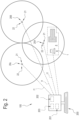
Figure 1 is a schematic view of an embodiment of the lawn mower robot according to the invention; -
Figure 2 schematically illustrates a view of the grass cutting system according to the invention. - It should be noted that the drawings are schematic representations and do not therefore represent the actual dimensions.
- The invention describes a
lawn mower system 100, characterised in that it comprises, in combination: - a
database 201; - a
remote server 200 connected to saiddatabase 201, - at least one
GNSS antenna 20A equipped with aGNSS receiving device 21 designed to receive from satellitesfirst GPS information 11 for determining GPS coordinates of the position of said antenna 20 and acommunication device 22 configured to establish a data connection with a telecommunication network, preferably with the Internet, for transmitting, at predetermined intervals, the first GPS information I1 derived from theGNSS receiving device 21 to saidremote server 200, theremote server 200 being configured for storing in thedatabase 201 at least partly the GPS information received from thecommunication device 22. - It should be noted that the
remote server 200 is defined by a remote processor, connectable to a network, preferably the Internet, by means of a connectingdevice 202. - The
database 201 is a memory, of the concentrated type (that is, present in a single processor) or distributed type (cloud). - The connection between the
database 201 and the remote processor may be performed through the Internet, using the connectingdevice 202, or thedatabase 201 may be integrated in theremote server 200. - According to the invention, the
system 100 further comprises alawn mower robot 1 comprising: - grass cutting means 2 for performing an operation for cutting grass,
- movement means 3 configured for moving the
lawn mower robot 1, - a GNSS receiving device 4 of the RTK type, configured to receive from GNSS satellites second GPS information to determine GPS coordinates regarding a GPS position of the
robot 1, - a
communication device 11 configured to establish a data connection with a telecommunication network, preferably with the Internet, - a processing module 7, operatively coupled to the GPS device 4 and to the
communication device 11 and configured for transmitting to theremote server 200, using thecommunication device 11, GPS coordinates of the GPS position of therobot 1. - The
remote server 200 is configured for sending to thecommunication device 11 of therobot 1 GPS correction information of the GPS position of therobot 1 derived from the information received from the GNSS satellites from the GNSS receivingdevice 21 of said GNSS antenna 20 and/or present in thedatabase 201 for said GNSS antenna 20. - Said processing module 7 is configured for calculating, on the basis of the GPS correction information and the GPS coordinates of the GPS position of the
robot 1 received from the GNSS receiving device 4 of the RTK type, a correct GPS position of therobot 1, according to a differential GPS positioning technique. - Advantageously, according to this technique, the correct GPS position is particularly accurate.
- It should also be noted that the fact of having a
remote server 200 makes it possible to optimise the data flow in the case of a multiplicity of robots 1: in effect, theantenna remote server 200 which activates the data flow (regarding the GPS correction information) towards therobot 1, on request. - Preferably, the data (correction information) from the
remote server 200 towards thecommunication device 11 of therobot 1 are sent. - In this way, there is no specific 1-1 connection between
antenna 20A androbot 1, whilst, on the other hand, it is the remote server which is interposed, optimising the data flow thanks to this architecture. - It should be noted that the expression "GPS correction information" is used to mean a plurality of data which may comprise at least a portion of the first GPS information I1 and/or the information present in the
database 201. - The "GPS correction information" may include GPS positions of
antenna 20A. - The "GPS correction information" may include GNSS satellite identification information whose first information was received by the
antenna 20A. - Since the
antenna 20A is positioned at an optimum distance relative to the robot 1 (preferably less than 30 km, even more preferably less than 20 km, with a further preference of less than 15 km), the correction derived by therobot 1 using the first GPS information I1 of theantenna 20A is an optimum correction also for therobot 1, that is to say, which can be applied to the GPS position of therobot 1, improving the accuracy of the GPS position acquired by the GNSS receiving device 4 of the RTK type. - In this way, the correct GPS position can be used by the processing module 7 to allow a particularly reliable movement.
- In this description, for brevity, reference will be made to the
lawn mower robot 1 simply as therobot 1. - According to the invention, the
robot 1 comprises aframe 10 for supporting the components of therobot 1. - The
robot 1 comprises grass cutting means 2, coupled to the supportingframe 10, configured to perform an operation for cutting grass inside a cutting zone A. - The cutting zone A may be, for example, a garden, a park or in general a lawn.
- The grass cutting means 2 face towards the grass and comprise grass cutting elements, for example, one or more blades.
- According to an aspect of the invention, the cutting means 2 comprise an actuator, not illustrated in the accompanying drawings, configured for moving said grass cutting elements.
- According to the invention, the
robot 1 comprises movement means 3, coupled to the supportingframe 10, configured for moving therobot 1. The GNSS receiving device 4 of the RTK type is configured to derive coordinates regarding a GPS position of therobot 1. - Advantageously, a GPS type device 4 which uses RTK technology, that is to say, measurements of satellite data with respect to a fixed ground station (
antenna 20A), makes it possible to obtain information with a greater degree of precision compared with the standard GPS systems. The term "coupled" means that thecommunication device 11 and the GPS type device 4 are connected to, and in communication with, the processing module 7. - According to an aspect of the invention, the movement means 3 are configured for moving the
robot 1 along a feed direction X. - Preferably, the movement means 3 comprise a plurality of wheels 3A. Preferably, at least one wheel 3A is a drive wheel and the movement means 3 comprise a rotation motor (not illustrated), operatively connected to said at least one drive wheel.
- Still more preferably, at least one wheel 3A is a wheel which can be oriented, that is to say, a wheel which is able to rotate about a substantially vertical axis of rotation, and the movement means 3 comprise an orientation motor (not illustrated) operatively connected to said at least one wheel which can be oriented.
- In particular, the drive wheels allow the forward movement along the feed direction, whilst the adjustable wheels change the feed direction when necessary (for example, when obstacles are detected along the working trajectory or the edges of the area to be maintained are reached).
- By way of example, and therefore non-limiting, the power supply of the
robot 1, both with regard to the movement means 3 and the cutting means 2, may be performed by electric motors, powered by a battery; the latter may be of the rechargeable type (not illustrated). - Preferably, the battery may also power other electrical/electronic devices provided on the
lawn mower robot 1. - The processing module 7 is configured for controlling the movement means 3 of the GPS coordinates stored in the storage unit 8 (and of a trajectory stored in the processing module 7 or received, for example received from the remote server 201).
- According to another aspect, the at least one
GNSS antenna 20A comprises a plurality ofantennas GNSS receiving device 21 designed to receive signals from GNSS satellites (first GPS information) for deriving GPS coordinates of the position of saidGNSS antenna communication device 22 configured to establish a data connection with a telecommunication network, preferably with the Internet, for transmitting, at predetermined intervals, the GPS coordinates of the position of saidantenna GNSS receiving device 21, to saidremote server 200. According to this aspect, theremote server 200 is configured for storing the coordinates of the GPS position of saidGNSS antennas database 201. - According to another aspect, the
remote server 200 is configured for storing a part of the first GPS information I1 of saidGNSS antennas database 201. - The fact of having
several antennas - Moreover, the correct GPS position, being particularly reliable, allows the
robot 1 to operate in any condition, for example even in the presence of obstacles or in zones which can degrade the quality of the GPS signal received from therobot 1. - In these circumstances, the correct GPS position, calculated by the processing module 7, allows the
robot 1 to operate in a particularly reliable manner. - It should be noted that the correct GPS position is the basis for moving the robot 1 (the more accurate is the GPS position derived from the processing module 7 the greater is the precision in cutting and managing the obstacles by the robot 1).
- According to another aspect, the
remote server 200 is configured for: - comparing said coordinates of the GPS position in which the
robot 1 is positioned with a plurality of GPS coordinates of theGNSS antennas - determining, by means of said comparison, a
GPS antenna 20A having, among saidGPS antennas robot 1 is positioned; - sending to the
communication device 11 of therobot 1 information for GPS correction of the GPS position of therobot 1 derived on the basis of the first GPS information I1 received from theantenna 20A and/or the information present in thedatabase 201 for saidantenna 20A having a smaller distance relative to the localisation point in which therobot 1 is positioned. - According to this embodiment, the
antenna 20A closest to the position of the robot is used to calculate the correct GPS position. - In this way, the correction applied by the
robot 1 is optimum for improving the accuracy: in effect, theclosest antenna 20A is in all probability the antenna the correction for which, compared with the others, is better for the robot 1 (in particular for the GPS position where therobot 1 is located). According to another aspect, theremote server 100 is configured for detecting a malfunction of theantenna 20A. - In the case of detection of a malfunction of the
antenna 20A having a smaller distance than the localisation position in which therobot 1 is positioned, that is, thefirst antenna 20A, theremote server 200 is configured to determine, by means of said comparison, a furthersecond GNSS antenna 20B having, among saidGPS antennas first antenna 20A, the smaller distance relative to the localisation position in which therobot 1 is positioned. - In short, the correction which is sent the
communication device 11 of therobot 1 from theremote server 200 in the case of a malfunction of the antenna at the least distance corresponds to that of the second closest active antenna (since the first antenna is malfunctioning, the correction of the second antenna is sent in order of distance). - In this way, the
system 1 is able to manage in an effective manner the operation of therobot 1, even in the case of a malfunction of one or more antennas. - According to another aspect, the
communication device 22 is configured for transmitting, at predetermined intervals, identification information of the GNSS satellites whose GPS signals have been received from theGNSS receiving device 21 and wherein the processing module 7 is configured for transmitting to theremote server 200 identification information of the GNSS satellites whose GPS signals have been received from the GNSS receiving device 4 of the RTK type. - In essence, the
remote server 200 receives the list of the GNSS satellites which can be received by therobot 1 and the list of the GNSS satellites which can be received by eachantenna - Preferably, but not necessarily, the list of GNSS satellites which can be received by the
robot 1 and/or the list of GNSS satellites which can be received by eachantenna database 201. - According to this aspect, the
remote server 200 is configured for: - comparing for each
GNSS antenna GNSS receiving device 21 of saidantennas - determining, by means of said comparison, a
GPS antenna 20A having, among saidGPS antennas - sending to the
communication device 11 of therobot 1 GPS correction information of the GPS position of therobot 1 derived from the first GPS information I1 received from the GNSS satellites from theGNSS receiving device 21 of saidGNSS antenna 20A and/or present in thedatabase 201 for saidGNSS antenna 20A, said GPS correction information being relative to saidantenna 20A having the greatest number of GNSS satellites transmitting the first GPS I1 information to theGNSS receiving device 21 in common with GNSS satellites whose second information has been received by the GNSS receiving device 4 of the RTK type. - Basically, according to this aspect, the correction of the GPS position which is sent by the
remote server 200 to thecommunication device 11 of therobot 1 corresponds to theantenna 20A which has more GNSS satellites which can be received in common with those which can be received by therobot 1, where "which can be received" means the fact that the signal of that GNSS satellite is received (preferably within a certain power level). - The fact that the
antenna 20A which is used for the correction has the greatest number of satellites which can be received in common with the robot means that the correction is appropriate and accurate for therobot 1, since it is derived from the same or substantially the same set of GNSS satellites. - According to another aspect, in the case of detection of a malfunction of the above-mentioned
antenna 20A having the greatest number of GNSS satellites in common with the GNSS satellites whose signals have been received from the RTK type GNSS receiving device 4, that is, thefirst antenna 20A, theremote server 200 is configured to determine, by means of said comparison, a furthersecond GNSS antenna 20B having, between saidGPS antennas first antenna 20A, the greatest number of GNSS satellites in common with the GNSS satellites whose signals have been received from the RTK type GNSS receiving device 4. - According to another aspect, the
communication device 11 of therobot 1 and/or thecommunication device 22 of the antenna 20 comprises a wireless communication module. - According to yet another aspect, the
communication device 11 of therobot 1 and/or thecommunication device 22 of the antenna 20 comprises a 4G mobile type communication module. - According to another aspect, the
communication device 11 of therobot 1 and/or thecommunication device 22 of the antenna 20 comprises a mobile GPRS telephone device, configured to be able to exchange data traffic. According to yet another aspect, saidantennas robot 1, at a predetermined distance of less than 30 km, even more preferably less than 20 km. - It should be noted that, experimentally, it has been verified that these distances make it possible to optimise the number of antennas scattered in a certain territory with respect to the accuracy of the correct GPS position: in essence, the optimum condition of coverage can be obtained by applying
antennas robot 1 could operate) there is anantenna - According to another aspect, the
remote server 200 is configured for sending to thecommunication device 11 of the robot 1 a trajectory to be followed for cutting a cutting zone. - According to this aspect, the processing module 7 of the
robot 1 is configured for controlling the movement means 3 of thelawn mower robot 1 on the basis of said trajectory and the correct GPS position. - In short, the
remote server 200, according to this aspect, comprises amemory 203 in which trajectories are present, in association withpredetermined robots 1. - For this reason, the
remote server 200 transmits movement information to the processing module 7, which is used by the processing module 7 together with the correct GPS position to control the movement means 3 and cut the cutting area A. - Some aspects relating to the
antenna 20A and/or plurality ofantennas - According to a first aspect, preferably but not necessarily, upon the installation of a
new antenna 20A the "real" position of the antenna is stored in thedatabase 201, where the term "real" position means a position calculated with a plurality of modes and therefore considered particularly reliable. - This "real" position of the
antenna 20A may define, together with other data, the above-mentioned correction information. - For example, the installer may use a combination of techniques for deriving the "real" position of the antenna.
- The "real" position is used in combination with the first GPS information I1 derived from the GNSS satellites for calculating the correct GPS position of the
robot 1. - According to a second aspect, the real position of the
antenna 20A is calculated by acquiring first GPS information I1 in a predetermined time interval. This time interval is sufficiently large to allow theantenna 20A to receive the first GPS information from the GNSS satellites, and consequently calculate the GPS coordinates, using a plurality of GNSS satellites and/or with the same set of GNSS satellites in different positions of the sky. In short, according to this aspect, the real position of theantenna 20A is a mathematical function of a plurality of GPS positions acquired over time. - Preferably, but not necessarily, the real GPS position of the
antenna 20A is an average of these positions, over time. - The real position for a
specific antenna 20A is preferably stored in thedatabase 201 in association with theantenna 20A itself. - The correction information, sent by the
remote server 201 to thecommunication device 11 of therobot 1, preferably comprises the real position. - Further, the correction information also comprises at least a part (or all) of the first GNSS information of a specific selected antenna.
- According to another preferred embodiment, the
communication device 11 of therobot 1 sends the GPS position of therobot 1 to theremote server 201 only at predetermined operating steps, for example at the start of the working phase, that is to say, at the start of the cut or when about to start the cut. - Alternatively, the
communication device 11 of therobot 1 sends the GPS position of therobot 1 to theremote server 201 at predetermined time intervals, preferably less than 20 seconds, even more preferably less than 10 seconds, most preferably less than 5 seconds. - Preferably, said time intervals correspond to a second.
- It should be noted that the
remote server 201 sends the correction information to thecommunication device 11 of therobot 1 at predetermined time intervals, preferably less than 20 seconds, even more preferably less than 10 seconds, most preferably less than 5 seconds. - The invention relates to a cutting process of a cutting zone A.
- According to the invention, the cutting process comprises the following steps:
- preparing a
cutting system 100 according to any one of the aspects described above as in the accompanying claims; - transmitting to the
remote server 200 GPS coordinates of a GPS position of therobot 1; - transmitting, at predetermined intervals, the first GPS information I1 received from the
GNSS receiving device 21 of saidGNSS antenna 20A to saidremote server 200; - storing at least a portion of the first GPS information I1 of said
antenna 20A in thedatabase 201; - sending to the
communication device 11 of therobot 1 GPS correction information of the GPS position derived from the first GPS information I1 received from the GNSS satellites from theGNSS receiving device 21 of said GNSS antenna 20 and/or present in thedatabase 201 for said GNSS antenna 20; - calculating, using said processing module 7, on the basis of the GPS correction information and the GPS coordinates received from the GNSS receiving device 4 of the RTK type, a correct GPS position, according to a differential GPS positioning technique;
- controlling the movement means 3 of the
robot 1, for cutting the grass in a cutting zone A, as a function of said correct GPS position. - According to another aspect, the step of preparing a
cutting system 100 comprises a step of preparing a plurality ofGNSS antennas GNSS receiving device 21 designed to receive from GNSS satellites first GPS information I1 for deriving GPS coordinates of the position of saidGNSS antenna communication device 22 configured to establish a data connection with a telecommunication network, preferably with the Internet, for transmitting, at predetermined intervals, the first GPS information I1 received from theGNSS receiving device 21 of said antenna to saidremote server 200. - The
remote server 200 is configured for storing at least a part of said first GPS information I1 of saidGNSS antennas database 201, and wherein: - the step of sending to the
communication device 11 of therobot 1 GPS correction information derived on the basis of the first GPS information I1 received from the GNSS satellites from theGNSS receiving device 21 of saidGNSS antenna 20A and/or present in thedatabase 201 for saidGNSS antenna 20A comprises a step of selecting one of saidGNSS antennas robot 1 derived on the basis of the GPS information received from the GNSS satellites from theGNSS receiving device 21 of said GNSS antenna 20 and/or present in thedatabase 201 for said selectedantenna 20A. - According to yet another aspect, the step of selecting one of said
GNSS antennas - comparing for each
GNSS antenna GNSS receiving device 21 of saidantennas - determining, by means of said comparison, a
GPS antenna 20A having, among saidGPS antennas antenna 20A having the largest number of GNSS satellites in common. - According to yet another aspect, the step of selecting one of said
GNSS antennas - comparing said coordinates of the GPS position in which the
robot 1 is positioned with a plurality of GPS coordinates of theGNSS antennas - determining, by means of said comparison, a
GPS antenna 20A having, among theGPS antennas robot 1 is positioned and selecting said antenna having a smaller distance and selecting saidantenna 20A having a smaller distance.
Claims (16)
- A lawn mower system (100), characterised in that it comprises, in combination:- a database (201);- a remote server (200) connected to said database (201),- at least one GNSS antenna (20A) equipped with a GNSS receiving device (21) designed to receive from satellites first GPS information I1 for determining GPS coordinates of the position of said antenna (20) and a communication device (22) configured to establish a data connection with a telecommunication network, preferably with the Internet, for transmitting, at predetermined intervals, the first GPS information I1 derived from the GNSS receiving device (21) to said remote server (200), the remote server (200) being configured for storing in the database (201) at least partly the GPS information received from the communication device (22);- a lawn mower robot (1), comprising:- grass cutting means (2) for performing an operation for cutting grass,- movement means (3) configured for moving the lawn mower robot (1),- a GNSS receiving device (4) of the RTK type, configured to receive from GNSS satellites second GPS information to determine GPS coordinates regarding a GPS position of the robot (1),- a communication device (11) configured to establish a data connection with a telecommunication network, preferably with the Internet,- a processing module (7), operatively coupled to the GPS device (4) and to the communication device (11) and configured for transmitting to the remote server (200), by means of the communication device (11), GPS coordinates of the GPS position of the robot (1) and wherein the remote server (200) is configured to send to the communication device (11) of the robot (1) GPS correction information of the GPS position of the robot (1) derived from the information received from the GNSS satellites from the GNSS receiving device (21) of said GNSS antenna (20) and/or present in the database (201) for said GNSS antenna (20), said processing module (7) being configured to calculate, on the basis of the GPS correction information and the GPS coordinates of the GPS position of the robot (1) received from the GNSS receiving device (4) of the RTK type, a correct GPS position of the robot (1), according to a differential GPS positioning technique.
- The lawn mower system (100) according to claim 1, wherein the at least one GNSS antenna (20A) comprises a plurality of GNSS antennas (20A, 20B, 20C), each antenna (20A, 20B, 20C) being equipped with a GNSS receiving device (21) designed to receive from GNSS satellites first GPS information I1 for deriving GPS coordinates of the position of said GNSS antennas (20A, 20B, 20C) and a communication device (22) configured to establish a data connection with a telecommunication network, preferably with the Internet, for transmitting, at predetermined intervals, the GPS information derived from the GNSS receiving device (21) of the position of said GNSS antennas (20A, 20B, 20C) to said remote server (200), the remote server (200) being configured to store in the database (201) at least partly the GPS information received from the communication device (22) of each GNSS antenna (20A, 20B, 20C).
- The lawn mower system (100) according to claim 2, wherein the remote server (200) is configured for:- comparing, at predetermined time intervals, said coordinates of the GPS position in which the robot (1) is positioned with a plurality of GPS coordinates of the GNSS antennas (20A, 20B, 20C);- determining, by means of said comparison, a GPS antenna (20A) having, among said GPS antennas (20A, 20B, 20C), a smaller distance than the GPS position in which the robot (1) is positioned;- sending to the communication device (11) of the robot (1) GPS correction information of the GPS position of the robot (1) derived from the information received from the GNSS satellites from the GNSS receiving device (21) of said GNSS antenna (20A) and/or present in the database (201) for said GNSS antenna (20A), said GPS correction information being relative to said antenna (20A) having a smaller distance than the GPS position in which the robot (1) is positioned.
- The lawn mower system (100) according to claim 3, wherein in the case of detection of a malfunction of the antenna (20A) having a smaller distance than the GPS position in which the robot (1) is positioned, that is, the first antenna (20A), the remote server (200) is configured to determine, by means of said comparison, a further second GNSS antenna (20B) having, among said GPS antennas (20A, 20B, 20C) excluding the first antenna (20A), the smaller distance relative to the GPS position in which the robot (1) is positioned.
- The lawn mower system (100) according to any one of claims 2 to 4, wherein the communication device (22) is configured for transmitting, at predetermined intervals, identification information of the GNSS satellites the first GPS information I1 of which has been received by the GNSS receiving device (21) and wherein the processing module (7) is configured for transmitting to the remote server (200) identification information of the GNSS satellites whose second GPS information has been received by the GNSS receiving device (4) of the RTK type.
- The lawn mower system (100) according to the preceding claim, wherein the remote server (200) is configured for:- comparing for each GNSS antenna (20A, 20B, 20C), the GNSS satellites whose first GPS information I1 has been received by the GNSS receiving device (21) of said antennas (20A, 20B, 20C) with the GNSS satellites whose second GPS information has been received by the GNSS receiving device (4) of the RTK type;- determining, by means of said comparison, a GPS antenna (20A) having, among said GPS antennas (20A, 20B, 20C), the largest number of GNSS satellites for which the first information has been received in common with the GNSS satellites for which second GPS information has been received by the GNSS receiving device (4) of the RTK type;- sending to the communication device (11) of the robot (1) GPS correction information of the GPS position of the robot (1) derived from the first GPS information I1 received from the GNSS satellites from the GNSS receiving device (21) of said GNSS antenna (20A) and/or present in the database (201) for said GNSS antenna (20A), said GPS correction information being relative to said antenna (20A) having the greatest number of GNSS satellites transmitting the first GPS I1 information to the GNSS receiving device (21) in common with GNSS satellites whose second information has been received by the GNSS receiving device (4) of the RTK type.
- The lawn mower system (100) according to claim 6, wherein in the case of detection of a malfunction of the above-mentioned antenna (20A) having the largest number of GNSS satellites transmitting the first GPS information I1 to the GNSS receiving device (21) in common with the GNSS satellites for which second GPS information has been received by the GNSS receiving device (4) of the RTK type, that is, first antenna (20A), the remote server (200) being configured to determine, by means of said comparison, a further second GNSS antenna (20B) having, among said GPS antennas (20A, 20B, 20C) excluding the above-mentioned first antenna (20A), the largest number of GNSS satellites transmitting the first GPS information I1 to the GNSS receiving device (21) in common with the GNSS satellites for which second GPS information has been received by the GNSS receiving device (4) of the RTK type.
- The lawn mower system (100) according to any one of the preceding claims, wherein the communication device (11) of the robot (1) and/or the communication device (22) of the antenna (20) comprises a wireless communication module.
- The lawn mower system (100) according to any one of the preceding claims, wherein the communication device (11) of the robot (1) and/or the communication device (22) of the antenna (20) comprises a mobile communication module of the 4G type.
- The lawn mower system (100) according to any one of the preceding claims, wherein the communication device (11) of the robot (1) and/or the communication device (22) of the antenna (20) comprises a mobile GPRS telephone device, configured to be able to exchange data traffic.
- The lawn mower system (100) according to any one of the preceding claims and claim 2, wherein the GNSS antennas (20A, 20B, 20C) are positioned, relative to said robot (1), at a distance of less than 30 km, even more preferably less than 20 km.
- The lawn mower system (100) according to any one of the preceding claims, wherein the remote server (200) is configured to send to the communication device (11) a trajectory to be followed for cutting a cutting zone, the processing module (7) being configured to control the movement means (3) of the lawn mower robot (1) on the basis of said trajectory and the correct GPS position.
- A method for cutting a cutting zone (A) comprising the following steps:- preparing a cutting system (100) according to any one of the preceding claims;- transmitting to the remote server (200) GPS coordinates of a GPS position of the robot (1);- transmitting, at predetermined intervals, the first GPS information I1 received from the GNSS receiving device (21) of said GNSS antenna (20A) to said remote server (200);- storing at least a portion of the first GPS information I1 of said antenna (20A) in the database (201);- sending to the communication device (11) of the robot (1) GPS correction information of the GPS position derived from the first GPS information I1 received from the GNSS satellites from the GNSS receiving device (21) of said GNSS antenna (20) and/or present in the database (201) for said GNSS antenna (20);- calculating, using said processing module (7), on the basis of the GPS correction information and the GPS coordinates received from the GNSS receiving device (4) of the RTK type, a correct GPS position, according to a differential GPS positioning technique;- controlling the movement means (3) of the robot (1), for cutting the grass in a cutting zone (A), as a function of said correct GPS position.
- The method according to the preceding claim, wherein the step of preparing a cutting system (100) comprises a step of preparing a plurality of GNSS antennas (20A, 20B, 20C), each equipped with a GNSS receiving device (21) designed to receive from GNSS satellites first GPS information I1 for deriving GPS coordinates of the position of said GNSS antenna (20A, 20B, 20C) and a communication device (22) configured to establish a data connection with a telecommunication network, preferably with the Internet, for transmitting, at predetermined intervals, the first GPS information I1 received from the GNSS receiving device (21) of said antenna to said remote server (200), the remote server (200) being configured for storing at least a part of said first GPS information I1 of said GNSS antennas (20A, 20B, 20C) in the database (201), and wherein:- the step of sending to the communication device (11) of the robot (1) GPS correction information derived on the basis of the first GPS information I1 received from the GNSS satellites from the GNSS receiving device (21) of said GNSS antenna (20A) and/or present in the database (201) for said GNSS antenna (20A) comprises a step of selecting one of said GNSS antennas (20A, 20B, 20C) , and to transmit GPS correction information of the GPS position of the robot (1) derived on the basis of the GPS information received from the GNSS satellites from the GNSS receiving device (21) of said GNSS antenna (20) and/or present in the database (201) for said selected antenna (20A).
- The method according to the preceding claim, wherein the step of selecting one of said GNSS antennas (20A, 20B, 20C) comprises a step of:- comparing for each GNSS antenna (20A, 20B, 20C), the GNSS satellites whose first GPS information I1 has been received by the GNSS receiving device (21) of said antennas (20A, 20B, 20C) with the GNSS satellites whose second GPS information has been received by the GNSS receiving device (4) of the RTK type;- determining, by means of said comparison, a GPS antenna (20A) having, among said GPS antennas (20A, 20B, 20C), the largest number of GNSS satellites for which the first information has been received in common with the GNSS satellites for which second GPS information has been received by the GNSS receiving device (4) of the RTK type and selecting said antenna (20A) having the largest number of GNSS satellites in common.
- The method according to claim 14, wherein the step of selecting one of said GNSS antennas (20A, 20B, 20C) comprises a step of:- comparing said coordinates of the GPS position in which the robot (1) is positioned with a plurality of GPS coordinates of the GNSS antennas (20A, 20B, 20C),- determining, by means of said comparison, a GPS antenna (20A) having, among the GPS antennas (20A, 20B, 20C), a smaller distance than the GPS position in which the robot (1) is positioned and selecting said antenna having a smaller distance and selecting said antenna (20A) having a smaller distance.
Priority Applications (1)
| Application Number | Priority Date | Filing Date | Title |
|---|---|---|---|
| EP24158724.5A EP4350394A2 (en) | 2022-09-20 | 2023-09-18 | System for cutting grass and corresponding process |
Applications Claiming Priority (1)
| Application Number | Priority Date | Filing Date | Title |
|---|---|---|---|
| IT202200019245 | 2022-09-20 |
Related Child Applications (2)
| Application Number | Title | Priority Date | Filing Date |
|---|---|---|---|
| EP24158724.5A Division-Into EP4350394A2 (en) | 2022-09-20 | 2023-09-18 | System for cutting grass and corresponding process |
| EP24158724.5A Division EP4350394A2 (en) | 2022-09-20 | 2023-09-18 | System for cutting grass and corresponding process |
Publications (1)
| Publication Number | Publication Date |
|---|---|
| EP4343477A1 true EP4343477A1 (en) | 2024-03-27 |
Family
ID=84361997
Family Applications (2)
| Application Number | Title | Priority Date | Filing Date |
|---|---|---|---|
| EP23198046.7A Pending EP4343477A1 (en) | 2022-09-20 | 2023-09-18 | System for cutting grass and corresponding process |
| EP24158724.5A Pending EP4350394A2 (en) | 2022-09-20 | 2023-09-18 | System for cutting grass and corresponding process |
Family Applications After (1)
| Application Number | Title | Priority Date | Filing Date |
|---|---|---|---|
| EP24158724.5A Pending EP4350394A2 (en) | 2022-09-20 | 2023-09-18 | System for cutting grass and corresponding process |
Country Status (2)
| Country | Link |
|---|---|
| US (1) | US20240094404A1 (en) |
| EP (2) | EP4343477A1 (en) |
Citations (3)
| Publication number | Priority date | Publication date | Assignee | Title |
|---|---|---|---|---|
| US20110142099A1 (en) * | 2008-06-02 | 2011-06-16 | Nav On Time | Control device for one or more self-propelled mobile apparatus |
| US20190369620A1 (en) * | 2016-12-15 | 2019-12-05 | Positec Power Tools (Suzhou) Co., Ltd | Returning method of self-moving device, self-moving device, storage medium, and server |
| EP3698618A1 (en) * | 2017-11-16 | 2020-08-26 | Nanjing Chervon Industry Co., Ltd. | Smart lawn mowing system |
-
2023
- 2023-09-18 EP EP23198046.7A patent/EP4343477A1/en active Pending
- 2023-09-18 EP EP24158724.5A patent/EP4350394A2/en active Pending
- 2023-09-18 US US18/469,302 patent/US20240094404A1/en active Pending
Patent Citations (3)
| Publication number | Priority date | Publication date | Assignee | Title |
|---|---|---|---|---|
| US20110142099A1 (en) * | 2008-06-02 | 2011-06-16 | Nav On Time | Control device for one or more self-propelled mobile apparatus |
| US20190369620A1 (en) * | 2016-12-15 | 2019-12-05 | Positec Power Tools (Suzhou) Co., Ltd | Returning method of self-moving device, self-moving device, storage medium, and server |
| EP3698618A1 (en) * | 2017-11-16 | 2020-08-26 | Nanjing Chervon Industry Co., Ltd. | Smart lawn mowing system |
Also Published As
| Publication number | Publication date |
|---|---|
| EP4350394A2 (en) | 2024-04-10 |
| US20240094404A1 (en) | 2024-03-21 |
Similar Documents
| Publication | Publication Date | Title |
|---|---|---|
| US8527197B2 (en) | Control device for one or more self-propelled mobile apparatus | |
| CN107291077B (en) | Automatic working system, automatic moving equipment and control method thereof | |
| US20060167600A1 (en) | Architecturally partitioned automatic steering system and method | |
| EP1406140B1 (en) | System for determining an energy-efficient path of a machine | |
| EP3384318B1 (en) | Improved navigation for a vehicle by implementing two operating modes | |
| EP3324261B1 (en) | Automatic lawn mower robot and controlling method associated | |
| US7953526B2 (en) | Robotic vehicle controller | |
| EP3776393B1 (en) | Automatic lawnmower | |
| US20220124973A1 (en) | A Robotic Tool, and Methods of Navigating and Defining a Work Area for the Same | |
| AU2011235939A1 (en) | Method and apparatus for machine coordination which maintains line-of-site contact | |
| WO2009100463A1 (en) | Visual, gnss and gyro autosteering control | |
| EP3696576B1 (en) | Robotic vehicle for soil cultivation | |
| Han et al. | Preliminary results of the development of a single-frequency GNSS RTK-based autonomous driving system for a speed sprayer | |
| CN111045427A (en) | Right-angle turning method and system for crawler-type unmanned combine harvester | |
| CN113419529B (en) | Method for automatically guiding fault machine by machine and self-walking equipment | |
| EP4343477A1 (en) | System for cutting grass and corresponding process | |
| JPH09107717A (en) | Apparatus for controlling posture of working machine | |
| EP3695699B1 (en) | Robotic vehicle for boundaries determination | |
| CA3227432A1 (en) | Autonomous electric mower system and related methods | |
| US20230359221A1 (en) | Navigation for a robotic work tool system | |
| EP4268565B1 (en) | Improved navigation for a robotic work tool system | |
| US20240109445A1 (en) | Autonomous work system and autonomous work machine | |
| WO2024022204A1 (en) | Gardening tool, control method therefor, and system | |
| EP4068040A1 (en) | Improved operation for a robotic work tool | |
| US20240119842A1 (en) | Methods and Systems for Coupling Vehicles |
Legal Events
| Date | Code | Title | Description |
|---|---|---|---|
| PUAI | Public reference made under article 153(3) epc to a published international application that has entered the european phase |
Free format text: ORIGINAL CODE: 0009012 |
|
| STAA | Information on the status of an ep patent application or granted ep patent |
Free format text: STATUS: REQUEST FOR EXAMINATION WAS MADE |
|
| 17P | Request for examination filed |
Effective date: 20240220 |
|
| AK | Designated contracting states |
Kind code of ref document: A1 Designated state(s): AL AT BE BG CH CY CZ DE DK EE ES FI FR GB GR HR HU IE IS IT LI LT LU LV MC ME MK MT NL NO PL PT RO RS SE SI SK SM TR |