EP4174792A1 - Verfahren zum verstehen einer szene und semantische analyse von objekten - Google Patents
Verfahren zum verstehen einer szene und semantische analyse von objekten Download PDFInfo
- Publication number
- EP4174792A1 EP4174792A1 EP21306526.1A EP21306526A EP4174792A1 EP 4174792 A1 EP4174792 A1 EP 4174792A1 EP 21306526 A EP21306526 A EP 21306526A EP 4174792 A1 EP4174792 A1 EP 4174792A1
- Authority
- EP
- European Patent Office
- Prior art keywords
- voxel
- overlapping
- voxels
- occupancy grid
- contextual
- Prior art date
- Legal status (The legal status is an assumption and is not a legal conclusion. Google has not performed a legal analysis and makes no representation as to the accuracy of the status listed.)
- Withdrawn
Links
Images



Classifications
-
- G—PHYSICS
- G06—COMPUTING OR CALCULATING; COUNTING
- G06V—IMAGE OR VIDEO RECOGNITION OR UNDERSTANDING
- G06V20/00—Scenes; Scene-specific elements
- G06V20/10—Terrestrial scenes
- G06V20/176—Urban or other man-made structures
-
- G—PHYSICS
- G06—COMPUTING OR CALCULATING; COUNTING
- G06V—IMAGE OR VIDEO RECOGNITION OR UNDERSTANDING
- G06V10/00—Arrangements for image or video recognition or understanding
- G06V10/70—Arrangements for image or video recognition or understanding using pattern recognition or machine learning
- G06V10/74—Image or video pattern matching; Proximity measures in feature spaces
- G06V10/75—Organisation of the matching processes, e.g. simultaneous or sequential comparisons of image or video features; Coarse-fine approaches, e.g. multi-scale approaches; using context analysis; Selection of dictionaries
-
- G—PHYSICS
- G06—COMPUTING OR CALCULATING; COUNTING
- G06V—IMAGE OR VIDEO RECOGNITION OR UNDERSTANDING
- G06V10/00—Arrangements for image or video recognition or understanding
- G06V10/70—Arrangements for image or video recognition or understanding using pattern recognition or machine learning
- G06V10/74—Image or video pattern matching; Proximity measures in feature spaces
- G06V10/75—Organisation of the matching processes, e.g. simultaneous or sequential comparisons of image or video features; Coarse-fine approaches, e.g. multi-scale approaches; using context analysis; Selection of dictionaries
- G06V10/759—Region-based matching
-
- G—PHYSICS
- G06—COMPUTING OR CALCULATING; COUNTING
- G06V—IMAGE OR VIDEO RECOGNITION OR UNDERSTANDING
- G06V10/00—Arrangements for image or video recognition or understanding
- G06V10/70—Arrangements for image or video recognition or understanding using pattern recognition or machine learning
- G06V10/82—Arrangements for image or video recognition or understanding using pattern recognition or machine learning using neural networks
-
- G—PHYSICS
- G06—COMPUTING OR CALCULATING; COUNTING
- G06V—IMAGE OR VIDEO RECOGNITION OR UNDERSTANDING
- G06V2201/00—Indexing scheme relating to image or video recognition or understanding
- G06V2201/12—Acquisition of 3D measurements of objects
Definitions
- the present disclosure concerns the semantic analysis of scenes obtained through a point cloud generation process and provides a novel method for scene understanding and semantic analysis of objects in such scenes using a novel deep learning model.
- LiDAR Light Detection and Ranging
- BIM digitized building and infrastructure modeling
- 3D modeling of objects film and video games.
- a first sorting of the points of the point cloud by performing a classification of the points also known as semantic segmentation, enables further processing of the point cloud more feasible.
- the semantic segmentation clusters points of the point cloud into logical clusters or groups of points by attributing a semantic identification of the groups of points thereby allowing a semantic understanding of the 3D scene contained in the point cloud.
- Semantic segmentation of a 3D point cloud is traditionally performed by a human operator on special software, often expensive professional software. This work is fastidious and time-consuming. Borrowing from advancements in image processing and the implementation of deep-learning techniques for understanding 2D images, recent work with deep-learning network architectures and convolutional neural networks designed or adapted for 3D point clouds such as described in Maturana, D. and S. Scherer, 2015 "VoxNet: A 3D Convolutional Neural Network for Real-Time Object Recognition", 2015 IEEE/RSJ International Conference on Intelligent Robots and Systems (IROS) , have demonstrated promising results in segmentation. However, most use cases of the 3D point cloud networks are oriented towards identifying objects and less for scene understanding.
- a voxel is the term generally applied to a 3D regularly gridded space. It is the 3D analog to the pixel in raster and/or photographic images such as described in Kaufman et al., 1993; "Volume Graphics" IEEE Computer, Vol. 26, No. 7 July 1993, pp. 51-64 DOI: 10.1109/MC.1993.274942 .
- the use of this voxelization technique is seen in video games such as known under the trademark "Minecraft" or in 3D medical imaging.
- Roynard et al. addresses feature maps generated from multiple voxel dimensions and concatenation of multi-scale information.
- the model developed by Roynard et al. in "Classification of Point Cloud Scenes with Multiscale Voxel Deep Network" cited above includes a parallelized processing of the point cloud at different scales. The authors acknowledge that the model performance is sensitive to the choice of the three voxel dimensions. The output feature maps of the three parallel networks are then concatenated to perform the final step of the classification task.
- the size of the input data is 32x32x32 in x, y, z.
- the size capacity of the input data is another problem discussed in subsequent sections as it impacts the ability of the model to learn more quickly which will impact the time to maturity for the model.
- the model developed by Yang et al. cited hereabove takes advantage of not only the 2.5D object geometries (x, y, elevation), but intensity fields as well.
- the model adopts a fully convolutional network for single-stage dense object detection which is composed of two parts: a backbone network that extracts multi-scale features and a header network that outputs pixel-wise dense detection estimates.
- the backbone network provided creates the feature maps containing the multi-scale information which are eventually concatenated in the header network.
- the present disclosure concerns a novel method to generalize the 3D point cloud semantic segmentation and an equally novel convolutional neural network architecture designed to progressively carry the context in order for a system such as autonomous vehicle driving system to understand a scene and obtain a semantic analysis of such a scene.
- the present disclosure proposes to build a pipeline for treating a point cloud, such pipeline comprising generating a voxel occupancy grid structure, an iterative analysis of individual voxel volumes, generating a local contextual occupancy grid structure to prepare for segmentation, segmentation of volume's voxels, semantic labeling points of the point cloud falling within the volume structure, and a refined semantic ground segmentation.
- the proposed method targets the semantic segmentation of a 3D point cloud made of 3D points. It focuses mostly on real 3D point clouds acquired via LiDAR sensors in urban scenarios, but it is not limited to such data. Although 3D points can have many different attributes/modalities, the proposed method only makes use of the 3D coordinates of each point ( x , y and z ), thus any additional modality (such as colors, scan angles, etc.) is ignored which makes the method more versatile and useable for various applications.
- the present disclosure proposes a method for scene understanding and semantic analysis of such a scene comprising a neural network and comprising, starting from a 3D point cloud, a general pipeline comprising, based on the 3D coordinates of the points of the 3D point cloud, the steps of:
- the deep learning model used is preferably a convolutional neural network
- the resolution n is the length of a voxel edge.
- the resolution n defines the size of an edge of said voxels and is chosen according to the scale of the smallest type of object to segment.
- n is typically chosen in tens of centimeters.
- the iterative analysis of individual non-overlapping cubic volumes may comprise splitting said global 3D voxel occupancy grid structure into said non-overlapping cubic volumes of resolution N 3 where, N is a multiple of n.
- Said method may then comprise processing the totality of the input 3D point cloud by iterations over each of said non-overlapping cubic volumes.
- Said generating a local 3D contextual occupancy grid may comprise:
- Segmenting said non-overlapping cubic volumes may comprise segmenting each non-overlapping cubic volume using a deep-learning model trained to provide semantic labels, where the input of the model is the local contextual occupancy grid associated with a given non-overlapping cubic volume, and the output of the model is the semantic label of each voxel that belong to said given non-overlapping cubic volume.
- the local 3D contextual occupancy grid being a 3D image along 3 axes: x, y and z of respective sizes H, W and D
- the deep-learning model may process the local contextual occupancy grid by deriving three different 2D images, one along each axis and independently processing the three images by three "Dimension-As-Depth" blocks in which successive 2D convolution and 2D max pooling layers are applied until the output has the shape/dimension of said given non-overlapping cubic volume and wherein a fusion of the three outputs is done using a fully connected layer and a softmax layer such that the output of the model has the dimension of said given non-overlapping cubic volume, and each voxel is associated with a semantic label among selected classes.
- said selected classes preceded by their classification codes comprise:
- the method may also comprise associating each voxel with a semantic label after iterative processing of all the volumes and projecting back said labels on the 3D points by associating each voxel's label to the points that falls into it.
- the method may comprise processing voxels that are at the boundary of an object and the ground such that the boundary is refined up to a sub-voxel scale, wherein for each voxel labelled "ground" above which, relative to z axis, is a voxel with a different label, a local ground plane is fitted to the surrounding "ground” voxels and wherein said local plane is processed to enhance determination of the boundary between the ground assumed planar and the above objects such processing including assigning 3D points of the voxel that are close from the plane the label "ground”, otherwise, assigning the label of the above voxel to such 3D points.
- the present disclosure also concerns a 3D map comprising a classification of objects made according to any one of the previous features.
- the present disclosure further concerns a guiding device of a vehicle comprising such a 3D map.
- the present disclosure also concerns a computer program comprising instructions configured for executing the disclosed process and a non-transitory recording support readable by a computer system on which the computer program is recorded.
- the present disclosure as depicted in figure 1A and figure 1B is based on a general pipeline comprising two parts, part 100a in figure 1A and part 100b in figure 1B , the pipeline starting from a 3D point cloud 100 which is voxelized in step 115 according to a global occupancy grid structure of resolution n defined in step 110.
- the first step 110 of the pipeline is to generate the voxel occupancy grid from the point cloud.
- the voxel occupancy grid is defined as a 3D voxel grid of resolution n (meters), n being the length of an edge of the cubic voxels, where a voxel v has a value of 1 if it contains at least one point, 0 otherwise.
- the proposed approach of the present invention provides a simple occupancy grid structure in that the choice of the value attached to the voxel is strictly binary to make it independent of the point cloud density.
- This simple representation of the point cloud ensures a generalization to any type of 3D point cloud as it doesn't require any additional modality (such as color) that could make the model become dependent on a specific sensor.
- the voxel occupancy grid will give a similar result for two point clouds acquired with different sensors, meaning that for a model of 10 cm voxel size, any point cloud with a density higher than 1 point every 10 cm will provide very similar binary voxel grid.
- Both properties, mono-modal and constrained point cloud densities emphasize the normalization of the input of the model, while ensuring that the input remains lightweight.
- n is typically chosen in tens of centimeters.
- the point cloud is then processed by volumes. To do so, the voxel occupancy grid is divided in non-overlapping cubic volumes of size N 3 voxels.
- step 120 the binary voxel occupancy grid is split into non-overlapping cubic volumes of resolution N.
- n can be chosen equal to 25 cm and N can be chosen equal to 1 meter, the value of L being four in such case.
- the totality of the input 3D point cloud is processed using an iterative analysis of each non-overlapping cubic volume 130.
- Processing a volume involves segmenting the voxels that it contains.
- a local 3D contextual occupancy grid structure is used at step 131.
- the local 3D contextual occupancy grid structure comprises the contextual voxels around said cubic volume and is generated as follows:
- a given voxel v i of minimum vertex of coordinates X v i Y v i Z v i ⁇ R 3 is considered a contextual voxel if v i satisfies, for a given radius r ⁇ R + : X V ⁇ r ⁇ X v i ⁇ X V + N + r , Y V ⁇ r ⁇ Y v i ⁇ Y V + N + r , Z V ⁇ r ⁇ Z v i ⁇ Z V + N + r .
- Figure 2 illustrates the various levels: voxel 20, non-overlapping cubic volume 40, local 3D contextual occupancy grid structure 10 retrieved in step 132.
- x, y, z is the orthogonal basis for the coordinates of the points in the point cloud.
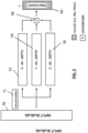
- Each volume is segmented using a deep learning model summed up in figure 3 .
- the deep-learning model is not only fed with voxels that belong to the current volume that is being processed, but also with the voxels from surrounding volumes according to the 3D local contextual occupancy grid 10. This is done to embed more contextual information when processing the voxels of a volume, while preventing border effects from appearing.
- each volume is segmented using the deep-learning model illustrated in figure 3 and figure 4 .
- the model used is a convolutional neural network.
- the input of the model is the local contextual occupancy grid data associated with the volume data
- the output of the classification is the semantic label of each voxel that belong to the current volume.
- the semantic labels are included in a list of 9 possible labels:
- voxel grids are usually processed using 3D convolutions, such an operation usually leads to a big increase in the number of parameters of the model as well as a costly increase in computational time.
- the present method relies on 2D convolutions. To do so, a 3D voxel grid is turned into a 2D image with d channels such that d equals the number of voxels of the axis chosen as the image channels.
- the local contextual occupancy grid is a 3D image of respective sizes H, W and D which is derived in three 2D images, along the three axes: x, y and z defined above, by the deep learning model or convolutional neural network.
- the deep learning model therefore processes the local contextual occupancy grid 50 by deriving 3 different 2D images, one along each axis or spatial dimension.
- a 2D image along an axis "a" can be defined as any permutation of the dimensions of the 3D image in which a ends-up as the last dimension, that is "a" is the channel dimension of the 2D image.
- a 2D image along axis x can be obtained by the two following permutations: (y, z, x) or (z, y, z). In both cases, the channel dimension of the image is along the x axis.
- the three 2D images obtained through the permutations 51 of figure 3 are independently processed by three "Dimension-As-Depth" blocks 52, 54, 56 receiving as input the volume and context data.
- L corresponds to the number of voxels contained along an axis of the volume.
- N 1 m
- the input 50 of the model is 32 x 32 x 32 voxels
- the output 60 of the model will be 4 x 4 x 4 x C, where C is the number of classes which here is equal to nine.
- a first level comprising:
- a concatenation 516 of the output of the second block is done on the last dimension with the raw feature previously cropped 515 from the center such that the height and width of the crop matches the height and width of the output of the second block.
- the second block is then repeated twice at 506, 507, 508, 509, 510, 511 with an intermediate concatenation 518 with secondly cropped 517 raw features, increasing the number of filters of the 2D convolutions to 128 and 256.
- the output is fed to two successive 2D final convolutions 512, 513 having 512 filters and 3x3 kernels, and to a final 2D convolution 514 with 9 filters and 1 ⁇ 1 kernels (Conv2D 1 ⁇ 1).
- the output of the three "Dimension-As-Depth" blocks are then concatenated along the last dimension all together and fed to an ultimate 3D convolution 514 having 9 filters and 1 ⁇ 1 ⁇ 1 kernels and having a softmax layer for numerical stability.
- the label of each voxel can be determined by taking the maximum values of each voxel along the last dimension of the output of the model.
- the model is trained using a ground truth point cloud of over 30 million points, resulting in more than 200 000 volumes. For each point, the label is known and belongs to the list hereabove.
- the output of the model is compared to the classes of the same volume in the ground truth using the so-called Focal-Loss introduced in Lin, T. Y., Goyal, P., Girshick, R., He, K., & Dollar, P. (2017) "Focal loss for dense object detection” In Proceedings of the IEEE international conference on computer vision (pp. 2980-2988 ).
- each voxel is associated with a semantic label. These labels are then projected back on the 3D points in step 140 of figure 1B by associating each voxel's label to the points that fall into it.
- Performances of the model are detailed in the following table 1.
- the performance is measured with the Intersection-over-Union metric, which is a common measure for semantic segmentation tasks in deep-learning.
- the processing time of the point cloud used for the numerical analysis is about 18s with a commercial GPU named GeForce ® RTX 2080 of the company NVIDIA ® .
- a further process illustrated in figure 1B consists in refining ground segmentation by refining detection of voxels that are at the boundary of an object and the ground as detected in step 150.
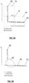
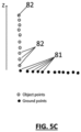
- Such voxels are processed in order that the boundary is refined up to a sub-voxel scale, as illustrated in Figures 5A, 5B , 5C for a 2D case.
- a local ground plane 73 is fitted to the surrounding "ground" voxels 70 as in figure 5B .
- This local plane is then used to better determine the boundary between the ground assumed locally planar and the above objects with respect to the points 83 which are to be reconsidered.
- 3D points 81 of the voxel 71 that are close from the plane are labelled "ground”, otherwise, they take the same label as the points 82 of the above voxel as in figure 5C .
- This process takes places at steps 160 local ground plane estimation and 170 segmentation refinement at ground level of figure 1B and is repeated at step 180 for every ground voxel under an object voxel.
- the described example illustrates the invention without limiting the coverage of the claims and in example, the size of the voxels, number of voxels in a volume and size of the contextual grid may be changed according to the size of objects to be segmented.
Landscapes
- Engineering & Computer Science (AREA)
- Theoretical Computer Science (AREA)
- Computer Vision & Pattern Recognition (AREA)
- Evolutionary Computation (AREA)
- General Physics & Mathematics (AREA)
- Multimedia (AREA)
- Physics & Mathematics (AREA)
- Health & Medical Sciences (AREA)
- Computing Systems (AREA)
- Databases & Information Systems (AREA)
- Artificial Intelligence (AREA)
- General Health & Medical Sciences (AREA)
- Medical Informatics (AREA)
- Software Systems (AREA)
- Image Analysis (AREA)
Priority Applications (1)
| Application Number | Priority Date | Filing Date | Title |
|---|---|---|---|
| EP21306526.1A EP4174792A1 (de) | 2021-10-29 | 2021-10-29 | Verfahren zum verstehen einer szene und semantische analyse von objekten |
Applications Claiming Priority (1)
| Application Number | Priority Date | Filing Date | Title |
|---|---|---|---|
| EP21306526.1A EP4174792A1 (de) | 2021-10-29 | 2021-10-29 | Verfahren zum verstehen einer szene und semantische analyse von objekten |
Publications (1)
| Publication Number | Publication Date |
|---|---|
| EP4174792A1 true EP4174792A1 (de) | 2023-05-03 |
Family
ID=78617351
Family Applications (1)
| Application Number | Title | Priority Date | Filing Date |
|---|---|---|---|
| EP21306526.1A Withdrawn EP4174792A1 (de) | 2021-10-29 | 2021-10-29 | Verfahren zum verstehen einer szene und semantische analyse von objekten |
Country Status (1)
| Country | Link |
|---|---|
| EP (1) | EP4174792A1 (de) |
Cited By (9)
| Publication number | Priority date | Publication date | Assignee | Title |
|---|---|---|---|---|
| CN116704137A (zh) * | 2023-07-27 | 2023-09-05 | 山东科技大学 | 一种海上石油钻井平台点云深度学习逆向建模方法 |
| CN117079091A (zh) * | 2023-08-18 | 2023-11-17 | 中国矿业大学 | 一种地铁隧道激光点云语义特征融合增强方法 |
| CN117274941A (zh) * | 2023-11-22 | 2023-12-22 | 安徽蔚来智驾科技有限公司 | 占用栅格预测方法和装置、智能设备和存储介质 |
| CN117392393A (zh) * | 2023-12-13 | 2024-01-12 | 安徽蔚来智驾科技有限公司 | 点云语义分割方法、计算机设备、存储介质及智能设备 |
| CN117523134A (zh) * | 2023-09-22 | 2024-02-06 | 南京林业大学 | 基于结构感知点云语义分割的三维建筑物模型简化方法 |
| CN117710977A (zh) * | 2024-02-02 | 2024-03-15 | 西南石油大学 | 基于点云数据的大坝bim三维模型语义快速提取方法及系统 |
| CN118628747A (zh) * | 2024-07-02 | 2024-09-10 | 中科合肥智能育种加速器创新研究院 | 融合图像和点云信息对水稻植株进行三维语义分割的方法 |
| CN120107761A (zh) * | 2025-01-16 | 2025-06-06 | 广东省科学院广州地理研究所 | 一种基于点云数据与机器学习的森林景观视觉质量评估方法及系统 |
| CN120894203A (zh) * | 2025-09-29 | 2025-11-04 | 揭阳职业技术学院 | 基于大模型的科技特派员场景实践教学辅助方法及系统 |
-
2021
- 2021-10-29 EP EP21306526.1A patent/EP4174792A1/de not_active Withdrawn
Non-Patent Citations (10)
| Title |
|---|
| KAUFMAN ET AL.: "Volume Graphics", IEEE COMPUTER, vol. 26, no. 7, July 1993 (1993-07-01), pages 51 - 64, XP000381152, DOI: 10.1109/MC.1993.274942 |
| LIN, T. Y.GOYAL, P.GIRSHICK, R.HE, K.DOLLAR, P.: "Focal loss for dense object detection", PROCEEDINGS OF THE IEEE INTERNATIONAL CONFERENCE ON COMPUTER VISION, 2017, pages 2980 - 2988 |
| LU HONGYA ET AL: "A 3D Convolutional Neural Network for Volumetric Image Semantic Segmentation", PROCEDIA MANUFACTURING, vol. 39, 1 January 2019 (2019-01-01), 43rd North American Manufacturing Research Conference, NAMRC 43, 8-12 June 2015, UNC Charlotte, North Carolina, United States, pages 422 - 428, XP055910338, ISSN: 2351-9789, Retrieved from the Internet <URL:https://pdf.sciencedirectassets.com/306234/1-s2.0-S2351978920X00035/1-s2.0-S2351978920304571/main.pdf?X-Amz-Security-Token=IQoJb3JpZ2luX2VjECEaCXVzLWVhc3QtMSJGMEQCIEgH7vRc2FASJrzDN2swZkjxMZHd7c5f7sz50MdYsh5rAiBaJLqQj52yRcfNzG3gygU09vtnfzWzf9NM2j9ZMHkVsCqDBAi6//////////8BEAQaDDA1OTAwMzU0Njg2NSIMeL0il> [retrieved on 20220407], DOI: 10.1016/j.promfg.2020.01.386 * |
| MATURANA DANIEL ET AL: "VoxNet: A 3D Convolutional Neural Network for real-time object recognition", 2015 IEEE/RSJ INTERNATIONAL CONFERENCE ON INTELLIGENT ROBOTS AND SYSTEMS (IROS), IEEE, 28 September 2015 (2015-09-28), pages 922 - 928, XP032831749, DOI: 10.1109/IROS.2015.7353481 * |
| MATURANA, D.S. SCHERER: "VoxNet: A 3D Convolutional Neural Network for Real-Time Object Recognition", 2015 IEEE/RSJ INTERNATIONAL CONFERENCE ON INTELLIGENT ROBOTS AND SYSTEMS, 2015 |
| QI, C.R.SU, H.MO, K.GUIBAS, L.J.: "PointNet: Deep Learning on Point Sets for 3D Classification and Segmentation", CONFERENCE ON COMPUTER VISION AND PATTERN RECOGNITION, 2017 |
| ROYNARD ET AL., CLASSIFICATION OF POINT CLOUD SCENES WITH MULTISCALE VOXEL DEEP NETWORK |
| ROYNARD ET AL.: "Classification of Point Cloud Scenes with Multiscale Voxel Deep Network", ARXIV:1804.03583VL, 10 April 2018 (2018-04-10) |
| XAVIER ROYNARD ET AL: "Classification of Point Cloud Scenes with Multiscale Voxel Deep Network", ARXIV.ORG, CORNELL UNIVERSITY LIBRARY, 201 OLIN LIBRARY CORNELL UNIVERSITY ITHACA, NY 14853, 10 April 2018 (2018-04-10), XP080869404 * |
| YANG ET AL.: "HDNET: Exploiting HD Maps for 3D Object Detection", CONFERENCE ON ROBOT LEARNING (CORL 2018) ARXIV:1804.03583 |
Cited By (12)
| Publication number | Priority date | Publication date | Assignee | Title |
|---|---|---|---|---|
| CN116704137A (zh) * | 2023-07-27 | 2023-09-05 | 山东科技大学 | 一种海上石油钻井平台点云深度学习逆向建模方法 |
| CN116704137B (zh) * | 2023-07-27 | 2023-10-24 | 山东科技大学 | 一种海上石油钻井平台点云深度学习逆向建模方法 |
| CN117079091A (zh) * | 2023-08-18 | 2023-11-17 | 中国矿业大学 | 一种地铁隧道激光点云语义特征融合增强方法 |
| CN117523134A (zh) * | 2023-09-22 | 2024-02-06 | 南京林业大学 | 基于结构感知点云语义分割的三维建筑物模型简化方法 |
| CN117274941A (zh) * | 2023-11-22 | 2023-12-22 | 安徽蔚来智驾科技有限公司 | 占用栅格预测方法和装置、智能设备和存储介质 |
| CN117274941B (zh) * | 2023-11-22 | 2024-06-11 | 安徽蔚来智驾科技有限公司 | 占用栅格预测方法和装置、智能设备和存储介质 |
| CN117392393A (zh) * | 2023-12-13 | 2024-01-12 | 安徽蔚来智驾科技有限公司 | 点云语义分割方法、计算机设备、存储介质及智能设备 |
| CN117710977A (zh) * | 2024-02-02 | 2024-03-15 | 西南石油大学 | 基于点云数据的大坝bim三维模型语义快速提取方法及系统 |
| CN117710977B (zh) * | 2024-02-02 | 2024-04-26 | 西南石油大学 | 基于点云数据的大坝bim三维模型语义快速提取方法及系统 |
| CN118628747A (zh) * | 2024-07-02 | 2024-09-10 | 中科合肥智能育种加速器创新研究院 | 融合图像和点云信息对水稻植株进行三维语义分割的方法 |
| CN120107761A (zh) * | 2025-01-16 | 2025-06-06 | 广东省科学院广州地理研究所 | 一种基于点云数据与机器学习的森林景观视觉质量评估方法及系统 |
| CN120894203A (zh) * | 2025-09-29 | 2025-11-04 | 揭阳职业技术学院 | 基于大模型的科技特派员场景实践教学辅助方法及系统 |
Similar Documents
| Publication | Publication Date | Title |
|---|---|---|
| CN118823139B (zh) | 一种基于大模型自标注的轻量化占用栅格预测方法及系统 | |
| CN112488210B (zh) | 一种基于图卷积神经网络的三维点云自动分类方法 | |
| CN111598030B (zh) | 一种航拍图像中车辆检测和分割的方法及系统 | |
| CN109934163B (zh) | 一种基于场景先验和特征再融合的航空图像车辆检测方法 | |
| CN109829399B (zh) | 一种基于深度学习的车载道路场景点云自动分类方法 | |
| CN110264468B (zh) | 点云数据标注、分割模型确定、目标检测方法及相关设备 | |
| Li et al. | Dual-view 3d object recognition and detection via lidar point cloud and camera image | |
| Ma et al. | Capsule-based networks for road marking extraction and classification from mobile LiDAR point clouds | |
| CN111145174A (zh) | 基于图像语义特征进行点云筛选的3d目标检测方法 | |
| CN114037640B (zh) | 图像生成方法及装置 | |
| CN112613378A (zh) | 3d目标检测方法、系统、介质及终端 | |
| CN114648698A (zh) | 基于PointPillars改进的3D目标检测系统 | |
| CN110569926B (zh) | 一种基于局部边缘特征增强的点云分类方法 | |
| Kumar et al. | A multi-faceted CNN architecture for automatic classification of mobile LiDAR data and an algorithm to reproduce point cloud samples for enhanced training | |
| Bieder et al. | Exploiting multi-layer grid maps for surround-view semantic segmentation of sparse lidar data | |
| CN116168246A (zh) | 一种用于铁路工程的弃渣场识别方法、装置、设备及介质 | |
| CN112950786A (zh) | 一种基于神经网络的车辆三维重建方法 | |
| CN116246033A (zh) | 一种面向非结构化道路的快速语义地图构建方法 | |
| CN118447233A (zh) | 基于动态上采样与多维注意力机制的红外目标检测方法 | |
| Gomez-Donoso et al. | Three-dimensional reconstruction using SFM for actual pedestrian classification | |
| CN119445208A (zh) | 顾及全局-局部自注意力机制的机载点云分类方法及系统 | |
| CN118982813A (zh) | 一种3d卷积和注意力机制的地面移动机器人可通行区域识别方法 | |
| US20250156997A1 (en) | Stochastic dynamic field of view for multi-camera bird’s eye view perception in autonomous driving | |
| Kim et al. | Improved semantic segmentation network using normal vector guidance for LiDAR point clouds | |
| CN117893757A (zh) | 一种基于rasg栅格化的月面连续坡度地形识别方法 |
Legal Events
| Date | Code | Title | Description |
|---|---|---|---|
| PUAI | Public reference made under article 153(3) epc to a published international application that has entered the european phase |
Free format text: ORIGINAL CODE: 0009012 |
|
| STAA | Information on the status of an ep patent application or granted ep patent |
Free format text: STATUS: THE APPLICATION HAS BEEN PUBLISHED |
|
| AK | Designated contracting states |
Kind code of ref document: A1 Designated state(s): AL AT BE BG CH CY CZ DE DK EE ES FI FR GB GR HR HU IE IS IT LI LT LU LV MC MK MT NL NO PL PT RO RS SE SI SK SM TR |
|
| STAA | Information on the status of an ep patent application or granted ep patent |
Free format text: STATUS: THE APPLICATION IS DEEMED TO BE WITHDRAWN |
|
| 18D | Application deemed to be withdrawn |
Effective date: 20231104 |