EP4130402A1 - Remote operation assistance server, remote operation assistance system, and remote operation assistance method - Google Patents
Remote operation assistance server, remote operation assistance system, and remote operation assistance method Download PDFInfo
- Publication number
- EP4130402A1 EP4130402A1 EP21803164.9A EP21803164A EP4130402A1 EP 4130402 A1 EP4130402 A1 EP 4130402A1 EP 21803164 A EP21803164 A EP 21803164A EP 4130402 A1 EP4130402 A1 EP 4130402A1
- Authority
- EP
- European Patent Office
- Prior art keywords
- remote operation
- work
- reference information
- assistance
- processing element
- Prior art date
- Legal status (The legal status is an assumption and is not a legal conclusion. Google has not performed a legal analysis and makes no representation as to the accuracy of the status listed.)
- Granted
Links
Images




Classifications
-
- E—FIXED CONSTRUCTIONS
- E02—HYDRAULIC ENGINEERING; FOUNDATIONS; SOIL SHIFTING
- E02F—DREDGING; SOIL-SHIFTING
- E02F9/00—Component parts of dredgers or soil-shifting machines, not restricted to one of the kinds covered by groups E02F3/00 - E02F7/00
- E02F9/20—Drives; Control devices
- E02F9/2025—Particular purposes of control systems not otherwise provided for
- E02F9/205—Remotely operated machines, e.g. unmanned vehicles
-
- E—FIXED CONSTRUCTIONS
- E02—HYDRAULIC ENGINEERING; FOUNDATIONS; SOIL SHIFTING
- E02F—DREDGING; SOIL-SHIFTING
- E02F9/00—Component parts of dredgers or soil-shifting machines, not restricted to one of the kinds covered by groups E02F3/00 - E02F7/00
- E02F9/20—Drives; Control devices
- E02F9/2025—Particular purposes of control systems not otherwise provided for
- E02F9/2054—Fleet management
-
- E—FIXED CONSTRUCTIONS
- E02—HYDRAULIC ENGINEERING; FOUNDATIONS; SOIL SHIFTING
- E02F—DREDGING; SOIL-SHIFTING
- E02F9/00—Component parts of dredgers or soil-shifting machines, not restricted to one of the kinds covered by groups E02F3/00 - E02F7/00
- E02F9/26—Indicating devices
- E02F9/261—Surveying the work-site to be treated
-
- G—PHYSICS
- G01—MEASURING; TESTING
- G01W—METEOROLOGY
- G01W1/00—Meteorology
- G01W1/10—Devices for predicting weather conditions
-
- G—PHYSICS
- G05—CONTROLLING; REGULATING
- G05D—SYSTEMS FOR CONTROLLING OR REGULATING NON-ELECTRIC VARIABLES
- G05D1/00—Control of position, course, altitude or attitude of land, water, air or space vehicles, e.g. using automatic pilots
- G05D1/0011—Control of position, course, altitude or attitude of land, water, air or space vehicles, e.g. using automatic pilots associated with a remote control arrangement
- G05D1/0038—Control of position, course, altitude or attitude of land, water, air or space vehicles, e.g. using automatic pilots associated with a remote control arrangement by providing the operator with simple or augmented images from one or more cameras located onboard the vehicle, e.g. tele-operation
-
- G—PHYSICS
- G06—COMPUTING OR CALCULATING; COUNTING
- G06Q—INFORMATION AND COMMUNICATION TECHNOLOGY [ICT] SPECIALLY ADAPTED FOR ADMINISTRATIVE, COMMERCIAL, FINANCIAL, MANAGERIAL OR SUPERVISORY PURPOSES; SYSTEMS OR METHODS SPECIALLY ADAPTED FOR ADMINISTRATIVE, COMMERCIAL, FINANCIAL, MANAGERIAL OR SUPERVISORY PURPOSES, NOT OTHERWISE PROVIDED FOR
- G06Q10/00—Administration; Management
- G06Q10/06—Resources, workflows, human or project management; Enterprise or organisation planning; Enterprise or organisation modelling
- G06Q10/063—Operations research, analysis or management
-
- G—PHYSICS
- G06—COMPUTING OR CALCULATING; COUNTING
- G06Q—INFORMATION AND COMMUNICATION TECHNOLOGY [ICT] SPECIALLY ADAPTED FOR ADMINISTRATIVE, COMMERCIAL, FINANCIAL, MANAGERIAL OR SUPERVISORY PURPOSES; SYSTEMS OR METHODS SPECIALLY ADAPTED FOR ADMINISTRATIVE, COMMERCIAL, FINANCIAL, MANAGERIAL OR SUPERVISORY PURPOSES, NOT OTHERWISE PROVIDED FOR
- G06Q50/00—Information and communication technology [ICT] specially adapted for implementation of business processes of specific business sectors, e.g. utilities or tourism
- G06Q50/02—Agriculture; Fishing; Forestry; Mining
-
- G—PHYSICS
- G06—COMPUTING OR CALCULATING; COUNTING
- G06Q—INFORMATION AND COMMUNICATION TECHNOLOGY [ICT] SPECIALLY ADAPTED FOR ADMINISTRATIVE, COMMERCIAL, FINANCIAL, MANAGERIAL OR SUPERVISORY PURPOSES; SYSTEMS OR METHODS SPECIALLY ADAPTED FOR ADMINISTRATIVE, COMMERCIAL, FINANCIAL, MANAGERIAL OR SUPERVISORY PURPOSES, NOT OTHERWISE PROVIDED FOR
- G06Q50/00—Information and communication technology [ICT] specially adapted for implementation of business processes of specific business sectors, e.g. utilities or tourism
- G06Q50/08—Construction
-
- E—FIXED CONSTRUCTIONS
- E02—HYDRAULIC ENGINEERING; FOUNDATIONS; SOIL SHIFTING
- E02F—DREDGING; SOIL-SHIFTING
- E02F3/00—Dredgers; Soil-shifting machines
- E02F3/04—Dredgers; Soil-shifting machines mechanically-driven
- E02F3/28—Dredgers; Soil-shifting machines mechanically-driven with digging tools mounted on a dipper- or bucket-arm, i.e. there is either one arm or a pair of arms, e.g. dippers, buckets
- E02F3/36—Component parts
- E02F3/42—Drives for dippers, buckets, dipper-arms or bucket-arms
- E02F3/43—Control of dipper or bucket position; Control of sequence of drive operations
- E02F3/435—Control of dipper or bucket position; Control of sequence of drive operations for dipper-arms, backhoes or the like
Definitions
- the present invention relates to a technology to assist remote operation of a plurality of work machines by an operator through a remote operation apparatus.
- a technology has been proposed to display on a remote server, which receives prescribed operational information from a work machine, weather conditions in conjunction with information related to raising of crops (specifically, map information including a work area of the work machine, and a standard growth management model relating to growth of crops) (see, for example, Patent Literature 1).
- the remote server extracts the map information including the work area of the work machine based on position information indicating the position of the work machine, extracts weather conditions corresponding to a region including the work area from weather conditions separately loaded, and displays the region in the map information and the weather conditions corresponding to the region in the map information side by side within a prescribed display area.
- Patent Literature 1 Japanese Patent Laid-Open No. 2016-075599
- an object of the present invention is to provide a server, or the like, capable of providing an operator of a work machine with information about influence of various regional weather conditions, such as precipitation and temperature, on the transfer and work of the work machine.
- a remote operation assistance server of the present invention is a remote operation assistance server configured to assist remote operation of a work machine by an operator through a remote operation apparatus.
- the remote operation assistance server comprises: a first assistance processing element configured to refer to a weather information database to recognize weather conditions over a first designated period in a past at a designated area where the work machine is present; and a second assistance processing element configured to generate first work reference information indicating the weather conditions over the first designated period in the past at the designated area recognized by the first assistance processing element and cause an output interface of the remote operation apparatus to output the first work reference information based on communication with the remote operation apparatus.
- a remote operation assistance system of the present invention comprises the remote operation assistance server of the present invention, and the remote operation device.
- the first work reference information indicating the weather conditions over the first designated period in the past at the designated area (or a designated point) where the work machine is present, is output to the output interface of the remote operation apparatus.
- the operator of the work machine to estimate changes in inherent properties of the ground at the designated area caused by the weather conditions over the first designated period in the past, and by extension, information about the properties of the ground after the changes, which influence the transfer or work of the work machine.
- a remote operation assistance system as an embodiment of the present invention shown in FIG. 1 comprises a remote operation assistance server 10, and a remote operation apparatus 20 for remote operation of a work machine 40.
- the remote operation assistance server 10, the remote operation apparatus 20, and the work machine 40 are configured to allow network communication with each other.
- the remote operation assistance server 10, a weather information database 11, and a ground information database 12 are configured to allow network communication with each other.
- An intercommunication network between the remote operation assistance server 10 and the remote operation apparatus 20 may be identical to or different from an intercommunication network between the remote operation assistance server 10 and the work machine 40.
- the "remote operation” is a concept indicating an operator operating the work machine 40 at a position distanced from the work machine 40 without riding on the work machine 40.
- the "operator” is a concept indicating a person who operates the work machine 40 by operating the remote operation apparatus 20.
- the remote operation assistance server 10 comprises a database 102, a first assistance processing element 121, and a second assistance processing element 122.
- the database 102 stores and holds taken image data or the like.
- the database 102 may be constituted of a database server separate from the remote operation assistance server 10.
- Each of the assistance processing elements which is constituted of a computation processing device (a single-core processor or a multi-core processor, or a processor core comprising these processors), reads necessary data and software from memory or other storage devices, and performs later-described computation processing on the data according to the software.
- the remote operation apparatus 20 comprises a remote control device 200, a remote input interface 210, and a remote output interface 220.
- the remote control device 200 which is constituted of a computation processing device (a single-core processor or a multi-core processor, or a processor core comprising these processors), reads necessary data and software from memory or other storage devices, and performs computation processing on the data according to the software.
- the remote input interface 210 comprises a remote operation mechanism 211.
- the remote output interface 220 comprises an image output device 221 and a remote wireless communication device 222.
- the remote operation mechanism 211 includes a travel operation device, a turning operation device, a boom operation device, an arm operation device, and a bucket operation device.
- Each of the operation devices has an operation lever that receives a rotating operation.
- the operation lever (travel lever) of the travel operation device is operated to move a lower traveling body 410 of the work machine 40.
- the travel lever may also function as a travel pedal.
- the travel pedal may be provided so as to be fixed to a base part or a lower end part of the travel lever.
- the operation lever (turning lever) of the turning operation device is operated to move a hydraulic turning motor, which constitutes a turning mechanism 430 of the work machine 40.
- the operation lever (boom lever) of the boom operation device is operated to move a boom cylinder 442 of the work machine 40.
- the operation lever (arm lever) of the arm operation device is operated to move an arm cylinder 444 of the work machine 40.
- the operation lever (bucket lever) of the bucket operation device is operated to move a bucket cylinder 446 of the work machine 40.
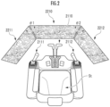
- Each of the operation levers comprised in the remote operation mechanism 211 is, for example, arranged around a seat St for the operator to sit on as shown in FIG. 2 .
- the seat St has a form of a high-back chair with armrests.
- the seat St may be a seating part in any form that enables the operator to sit on, such as the form of a low-back chair without a headrest or the form of a chair without a back.
- a pair of right and left travel levers 2110 are arranged laterally in a row.
- a single operation lever may function as a plurality of operation levers.
- a left-side operation lever 2111 provided on the front side of a left-side frame of the seat St shown in FIG. 2 , may function as an arm lever when operated in a front-rear direction, and may function as a turning lever when operated in a right-left direction.
- a right-side operation lever 2112 provided on the front side of a right-side frame of the seat St shown in FIG. 2 , may function as a boom lever when operated in the front-rear direction, and may function as a bucket lever when operated in the right-left direction.
- the lever pattern may optionally be changed in response to operation instructions by the operator.
- the image output device 221 is constituted of a central image output device 2210 arranged in front of the seat St, a left-side image output device 2211 arranged on a diagonally left front side of the seat St, and a right-side image output device 2212 arranged on a diagonally right front side of the seat St, the image output devices each having a substantially rectangular screen as shown in FIG. 2 .
- the screens (image display regions) of the central image output device 2210, the left-side image output device 2211, and the right-side image output device 2212 may be identical in shape and size to each other or may be different in shape and size from each other.
- a right edge of the left-side image output device 2211 is adjacent to a left edge of the central image output device 2210 such that the screen of the central image output device 2210 and the screen of the left-side image output device 2211 form an inclination angle ⁇ 1 (for example, 120° ⁇ ⁇ 1 ⁇ 150°).
- a left edge of the right-side image output device 2212 is adj acent to a right edge of the central image output device 2210 such that the screen of the central image output device 2210 and the screen of the right-side image output device 2212 form an inclination angle ⁇ 2 (for example, 120° ⁇ ⁇ 2 ⁇ 150°).
- the inclination angles ⁇ 1 and ⁇ 2 may be identical or different.
- the screens of the central image output device 2210, the left-side image output device 2211 and the right-side image output device 2212 may each be parallel to a perpendicular direction, and may be inclined to the perpendicular direction.
- At least one image output device, out of the central image output device 2210, the left-side image output device 2211, and the right-side image output device 2212, may be constituted of an image output device divided into a plurality of segments.
- the central image output device 2210 may be constituted of a pair of image output devices adjacent in up-down direction, the image output devices each having a substantially rectangular screen.
- the image output devices 2210 to 2212 may each further comprise a speaker (audio output device).
- the work machine 40 comprises an actual machine control device 400, an actual machine input interface 41, an actual machine output interface 42, and an actuating mechanism 440.
- the actual machine control device 400 which is constituted of a computation processing device (a single-core processor or a multi-core processor, or a processor core comprising these processors), reads necessary data and software from memory or other storage devices, and performs computation processing on the data according to the software.
- the work machine 40 for example, is a crawler shovel (construction machine). As shown in FIG. 3 , the work machine 40 comprises the crawler-type lower traveling body 410 and an upper turning body 420 turnably mounted on the lower traveling body 410 through a turning mechanism 430. In a front left part of the upper turning body 420, a cab 424 (operation room) is provided. In a front center part of the upper turning body 420, the actuating mechanism 440 is provided.
- the actual machine input interface 41 comprises an actual machine operation mechanism 411, an actual machine imaging device 412, and an actual machine positioning device 414.
- the actual machine operation mechanism 411 comprises a plurality of operation levers provided around a seat arranged inside the cab 424, as in the remote operation mechanism 211.
- the cab 424 is provided with a drive mechanism or a robot which receives signals corresponding to operation modes of remote operation levers and moves actual machine operation levers based on the signals.
- the actual machine imaging device 412 is installed, for example, inside the cab 424 to image the environment including at least part of the actuating mechanism 440 through a front window and a pair of right and left side windows. Some or all of the front window and the side windows may be omitted.
- the actual machine positioning device 414 is constituted of a GPS, and a gyro-sensor as necessary.
- the actual machine output interface 42 comprises an actual machine wireless communication device 422.
- the work mechanism 440 as an actuating mechanism comprises a boom 441 fitted to the upper turning body 420 in a derrickable manner, an arm 443 rotatably coupled to the tip of the boom 441, and a bucket 445 rotatably coupled to the tip of the arm 443.
- the work mechanism 440 is fitted with the boom cylinder 442, the arm cylinder 444, and the bucket cylinder 446, which are each constituted of an extendable hydraulic cylinder.
- the boom cylinder 442 is interposed between the boom 441 and the upper turning body 420 such that the boom cylinder 442 extends and retracts upon receiving a supply of hydraulic oil and thereby rotates the boom 441 in a derricking direction.
- the arm cylinder 444 is interposed between the arm 443 and the boom 441 such that the arm cylinder 444 extends and retracts upon receiving a supply of hydraulic oil and thereby rotates the arm 443 around a horizontal axis with respect to the boom 441.
- the bucket cylinder 446 is interposed between the bucket 445 and the arm 443 such that the bucket cylinder 446 extends and retracts upon receiving a supply of hydraulic oil and thereby rotates the bucket 445 around a horizontal axis with respect to the arm 443.
- FIG. 4 A first function of the above-configured remote operation assistance system will be described using a flowchart shown in FIG. 4 .
- blocks prefixed by "C" are used to simplify the description. These blocks signify data transmission and/or data reception, and signify condition branches where a process in a branching direction is executed, with both or one of the data transmission and the data reception as a condition. This also applies to a flowchart in FIG. 5 .
- the remote operation apparatus 20 determines the presence or absence of a designation operation by an operator through the remote input interface 210 (step 210 in FIG. 4 ).
- the "designation operation” is, for example, an operation such as the operator tapping in the remote input interface 210 to designate the work machine 40 as an intended machine for remote operation.
- the remote operation apparatus 20 ends the series of processes.
- the remote operation apparatus 20 transmits an environment confirmation request to the remote operation assistance server 10 through the remote wireless communication device 222 (step 212 in FIG. 4 ).
- the first assistance processing element 121 transmits the environment confirmation request to the pertinent work machine 40 (C10 in FIG. 4 ).
- the actual machine control device 400 acquires a taken image through the actual machine imaging device 412 (step 410 in FIG. 4 ).
- the actual machine control device 400 transmits taken image data representing the taken image to the remote operation assistance server 10 through the actual machine wireless communication device 422 (step 412 in FIG. 4 ).
- the second assistance processing element 122 transmits environment image data corresponding to the taken image to the remote operation apparatus 20 (step 110 in FIG. 4 ).
- the environment image data is the taken image data itself, and is also image data that represents a simulated environment image generated based on the taken image.
- the remote control device 200 When the remote operation apparatus 20 receives the environment image data through the remote wireless communication device 222 (C21 in FIG. 4 ), the remote control device 200 outputs an environment image corresponding to the environment image data to the image output device 221 (step 214 in FIG. 4 ).
- the remote control device 200 recognizes an operation mode of the remote operation mechanism 211 (step 216 in FIG. 4 ), and transmits a remote operation command corresponding to the operation mode to the remote operation assistance server 10 through the remote wireless communication device 222 (step 218 in FIG. 4 ).
- the first assistance processing element 121 transmits the remote operation command to the work machine 40 (C12 in FIG. 4 ).
- the actual machine control device 400 When the actual machine control device 400 receives the operation command through the actual machine wireless communication device 422 in the work machine 40 (C41 in FIG. 4 ), the actual machine control device 400 controls operation of the work mechanism 440 or the like (step 414 in FIG. 4 ). For example, a work of scooping up the soil in front of the work machine 40 by the bucket 445, turning the upper turning body 420, and then dropping the soil from the bucket 445 is executed.
- the remote operation apparatus 20 determines the presence or absence of a first designation operation by the operator through the remote input interface 210 (step 220 in FIG. 5 ).
- the "first designation operation” is an operation, such as tapping, in the remote input interface 210 to designate a single work machine 40 in a map indicating respective positions where the plurality of work machines 40 are present.
- the "first designation operation” may be determined as the operation identical to the "designation operation” or may be determined as an operation different from the "designation operation”.
- the remote operation apparatus 20 ends the series of processes.
- the determination result is positive (YES in step 220 in FIG.
- the remote operation apparatus 20 transmits a first work reference information request to the remote operation assistance server 10 through the remote wireless communication device 222 (step 221 in FIG. 5 ).
- the request includes a work machine identifier used to identify the work machine 40 which has established communication with the remote operation apparatus 20 or the work machine 40 designated through the remote input interface 210.
- the remote operation assistance server 10 When the remote operation assistance server 10 receives the first work reference information request (C13 in FIG. 5 ), the first assistance processing element 121 transmits a position information request to the work machine 40 identified by the work machine identifier included in the request (step 120 in FIG. 5 ).
- the actual machine control device 400 When the work machine 40 receives the position information request through the actual machine wireless communication device 422 (C42 in FIG. 5 ), the actual machine control device 400 recognizes the position information (identified by latitude and longitude) of the pertinent work machine 40 through the actual machine positioning device 414 (step 420 in FIG. 5 ). The actual machine control device 400 transmits the position information or position data representing the position information to the remote operation assistance server 10 through the actual machine wireless communication device 422 (step 422 in FIG. 5 ). The actual machine control device 400 ends the processing in the work machine 40.
- the position information or the position data representing the position information may be transmitted periodically to the remote operation assistance server 10.
- the first assistance processing element 121 recognizes the position information in the remote operation assistance server 10 (C14 in FIG. 5 )
- the first assistance processing element 121 recognizes the designated area where the pertinent work machine 40 is present (step 121 in FIG. 5 ).
- coordinate transformation of an imaging range may be conducted from an image coordinate system to a world coordinate system, and an area in the world coordinate system that extends based on the position according to the position information may be recognized as a designated area.
- the first assistance processing element 121 may refer to the weather information database 11 to recognize weather conditions over a first designated period in the past and a second designated period in the future (which may be identical in length to or different in length from the first designated period) at the designated area (step 122 in FIG. 5 ).
- the weather conditions include weather, duration of sunshine per unit time (e.g., one hour), temperature, humidity, precipitation, wind speed, wind direction, and atmospheric pressure, or one of these.
- the second assistance processing element 122 Based on the weather conditions at the designated area recognized by the first assistance processing element 121, the second assistance processing element 122 generates first work reference information and transmits the information to the remote operation apparatus 20 (step 124 in FIG. 5 ).
- the first work reference information includes a map M11 which encompasses at least part of a designated area A and which indicates a current position P of the work machine 40, as well as an address MAd of the current position P, an icon M12 indicating weather at current time in the designated area A, weather conditions M13 at current time in the designated area A (for example, temperature, humidity and wind speed), and diagrams M120, M122, and M124 which indicate transition of weather conditions (for example, temperature, weather, and precipitation) over the first designated period and the second designated period.
- the shape of the designated area A may be, for example, a circle of a given diameter extending around the current position P of the work machine 40, or a wide variety of shapes such as rectangular or polygonal shapes.
- a work area (registered in the database 102 in advance) where the work machine 40 carries out a work may be recognized as the designated area A.
- the remote control device 200 receives the first work reference information (C22 in FIG. 5 ), and outputs the first work reference information to the image output device 221 constituting the remote output interface 220 (step 222 in FIG. 5 ). Consequently, the first work reference information (or an image indicating the first work reference information) Img(Info1) as shown in FIG. 7 is output to the image output device 221.
- the first work reference information Img(Info1) includes, as described above, the map M11, and the diagrams M120, M122, and M124, or the like, which indicate transition of weather conditions (for example, temperature, weather, and precipitation) over the first designated period and the second designated period at the designated area A.
- the remote control device 200 may output to the image output device 221 constituting the remote output interface 220 the first work reference information Img(info1) so as to be superimposed on the work environment image Img(C) as shown in FIG. 9 .
- Outputting the first work reference information Img(info1) does not compromise the visibility of the color or the luminance of the ground in the work environment image Img(C). This enables the operator to recognize or estimate the properties of the ground in the designated area based on the color or the luminance of the ground in the designated area from the work environment image Img(C) itself, and enables the operator to determine the propriety of the estimation by comparison with the first work reference information.
- the remote operation apparatus 20 determines the presence or absence of a second designation operation by the operator through the remote input interface 210 (step 224 in FIG. 5 ).
- the "second designation operation” is an operation, such as tapping, in the remote input interface 210 to designate a single work machine 40 in the map indicating respective positions where the plurality of work machines 40 are present.
- the determination result is negative (No in step 224 in FIG. 5 )
- the process of determining the presence or absence of the first designation operation step 220 in FIG. 5
- onward are repeated.
- the determination result is positive (YES in step 224 in FIG.
- the remote operation apparatus 20 transmits a second work reference information request to the remote operation assistance server 10 through the remote wireless communication device 222 (step 226 in FIG. 5 ).
- the request includes the work machine identifier used to identify the work machine 40 which has established communication with the remote operation apparatus 20 or the work machine 40 designated through the remote input interface 210.
- the first assistance processing element 121 refers to the ground information database 12 based on the designated area where the work machine 40, identified by the work machine identifier included in the request, is present, and thereby recognizes intrinsic ground information at the designated area (step 126 in FIG. 5 ).
- the designated area may be designated based on the work machine identifier included in the request as described above (see step 120 ⁇ ⁇ ⁇ step 121 in FIG. 5 ).
- the ground information includes water content of the ground, and both or one of an N-value and a conversion N-value in consideration of geology.
- the first assistance processing element 121 may refer to the ground information database 12 to recognize ground information over the first designated period in the past and the second designated period in the future (which may be identical in length to or different in length from the first designated period) at the designated area (step 127 in FIG. 5 ).
- a storage device constituting the second assistance processing element 122 stores and holds, for example, a model as a result of learning a correlation between a mode of change over time in weather conditions and a mode of change in ground information by machine learning.
- a model as a result of learning a correlation between a mode of change over time in weather conditions and a mode of change in ground information by machine learning.
- an output of the model is recognized as the result of estimation or the result of prediction of the mode of change in the ground information.
- a tank model for computing a soil water index can be used, and further a model that reflects learning of geological properties in each designated area can be used.
- the second assistance processing element 122 Based on the weather conditions at the designated area and the ground information recognized by the first assistance processing element 121, the second assistance processing element 122 generates second work reference information and transmits the information to the remote operation apparatus 20 (step 128 in FIG. 5 ). For example, as shown in FIG.
- the second work reference information includes a map M21 which encompasses at least part of the designated area A and which indicates the current position P of the work machine 40, as well as the address MAd of the current position P, an icon M22 indicating the water content at current time in the designated area A, ground information M23 at current time in the designated area A (for example, the water content and the N-value), a diagram M220 indicating transition of the ground information (for example, the water content) over the first designated period and the second designated period, and diagrams M222 and M224 indicating transition of weather conditions.
- the remote control device 200 receives the second work reference information (C24 in FIG. 5 ), and outputs the second work reference information to the image output device 221 constituting the remote output interface 220 (step 228 in FIG. 5 ). Consequently, the second work reference information (or an image indicating the second work reference information) Img(Info2) as shown in FIG. 8 is output to the image output device 221.
- the second work reference information Img(Info2) includes, as described above, the map M11, and the diagram M220 or the like, which represents the transition of ground information (for example, the water content) over the first designated period and the second designated periods at the designated area A.
- the remote control device 200 may output to the image output device 221 constituting the remote output interface 220 the second work reference information Img(info2) so as to be superimposed on the work environment image Img(C) (see FIG. 9 ).
- Outputting the second work reference information Img(info2) does not compromise the visibility of the color or the luminance of the ground in the work environment image Img(C). This enables the operator to recognize or estimate the properties of the ground in the designated area based on the color or the luminance of the ground in the designated area from the work environment image Img(C) itself, and enables the operator to determine the propriety of the estimation by comparison with the second work reference information.
- the first operation reference information Img(info1) representing weather conditions (actual measurement values or analytic values) over the first designated period in the past and weather conditions (predictive values) over the second designated period in the future at the designated area A where the work machine 40 is present, is output to the remote output interface 220 of the remote operation apparatus 20 (see step 120 -> C42 -> step 420 -> step 422 -> C14 -> step 121 -> step 122 -> step 124 -> C22 -> step 222 in FIG. 5 , and FIG. 7 ).
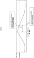
- the second assistance processing element 122 may generate the second work reference information indicating whether or not an index value, representing hardness or water content of the ground, as the properties of the ground at the designated area, is equal to or more than a first threshold that is set from a perspective of stable transfer of the work machine 40.
- a diagram including a curve indicating the mode of change over time in water content of the ground at the designated area (see a solid line) as well as a line segment indicating the first threshold (see a dashed line) may be generated as the second work reference information.
- the second work reference information may also include both or one of a notice notifying that the transfer of the work machine 40 is unstable during a time period in which the water content exceeds the first threshold after (or around) a scheduled time to start work with the work machine 40, and a notice notifying that recommended time to start work is after the end of the pertinent time period.
- the second assistance processing element 122 may generate the second work reference information indicating whether or not the index value representing the hardness or the water content of the ground, as the properties of the ground at the designated area, is equal to or less than a second threshold that is set from a perspective of easy work of the work machine 40.
- the second assistance processing element 122 may generate the second work reference information by superimposing the index value, indicating the hardness or the water content of the ground at the designated area where the work machine 40 is present, on the map information centered around the position where the work machine 40 is present.
- the map information of the map M31 indicating the current position P of the work machine 40 may include areas generated as the second work reference information.
- the areas include: an area M310 where the index value, representing the hardness or the water content of the ground as the properties of the ground, is equal to or more than the first threshold from the first designated period to the second designated period; an area M311 where the index value, which is equal to or more than the first threshold in the first designated period, is less than the first threshold over the second designated period; an area M312 where the index value is less than the first threshold from the first designated period to the second designated period; and an area M313 that is a forest or the like where the work machine 40 cannot be transferred.
- the respective areas 311 to 313 may be expressed by different colors, for example.
- the second work reference information at a given time from the first designated period to the second designated period may be generated.
- the remote operation assistance server with the above configuration can provide the operator of the work machine with information about the changes in the inherent properties of the ground caused by the weather conditions, such as precipitation and temperature, relating to the work machine included in the work environment image and each point in the area including the work machine, and by extension, information about the properties of the ground after the changes, which influence transfer or work of the work machine.
- the first assistance processing element refers to the weather information database to recognize, in addition to the weather conditions over the first designated period in the past at the designated area, predicted weather conditions over the second designated period in the future, and the second assistance processing element generates the first work reference information indicating, in addition to the weather conditions over the first designated period in the past at the designated area recognized by the first assistance processing element, the predicted weather conditions over the second designated period in the future, and causes the output interface of the remote operation apparatus to output the first work reference information based on the communication with the remote operation apparatus.
- the remote operation assistance server outputs the first operation reference information representing weather conditions over the first designated period in the past and the second designated period in the future at the designated area where the work machine is present, to the output interface of the remote operation apparatus.
- This enables the operator of the work machine to estimate or predict changes in inherent properties of the ground at the designated area caused by the weather conditions over the first designated period in the past, and the changes in the inherent properties of the ground at the designated area to be caused by the weather conditions over the second designated period in the future.
- This further enables the operator to estimate or predict the information about the properties of the ground after the changes in the future, which influence the transfer or work of the work machine.
- the first assistance processing element acquires a taken image including the work machine and a peripheral environment of the work machine acquired through the actual machine imaging device, and causes the output interface to output the work environment image corresponding to the taken image data based on the communication with the remote operation apparatus, and the first assistance processing element generates the first work reference information, with an area included in the work environment image output to the output interface as the designated area, and causes the output interface to output the first work reference information together with the work environment image.
- the remote operation assistance server with the above configuration, or the like, enables the operator of the work machine to estimate information about the changes in the inherent properties of the ground at the designated area caused by the weather conditions, such as precipitation and temperature, in the work machine included in the work environment image and in the designated area as an area including the work machine, and by extension, information about the properties of the ground after the changes, which influence transfer or work of the work machine.
- the weather conditions such as precipitation and temperature
- the second assistance processing element causes the output interface to output the first work reference information together with the work environment image, without compromising visibility of the color or the luminance of the ground in the work environment image.
- the remote operation assistance server with the above configuration, or the like, enables the operator to recognize or estimate the properties of the ground in the designated area based on the color or the luminance of the ground in the designated area from the work environment image itself, and enables the operator to determine the propriety of the estimation by comparison with the first work reference information.
- the first assistance processing element refers to the ground information database to recognize the inherent properties of the ground at the designated area
- the second assistance processing element estimates changes occurring in the inherent properties of the ground at the designated area recognized by the first assistance processing element, in response to the weather conditions at the designated area recognized by the first assistance processing element, generates the second work reference information indicating the properties of the ground at the designated area after the changes, and causes the output interface of the remote operation apparatus to output the second work reference information based on the communication with the remote operation apparatus.
- the remote operation assistance server estimates or predicts changes occurring in the inherent properties of the ground at the designated area where the work machine is present, in response to the weather conditions over the first designated period in the past (and the second designated period in the future) at the designated area, and outputs the second work reference information representing the estimated result to the output interface of the remote operation apparatus.
- This enables the operator of the work machine to recognize changes in inherent properties of the ground at the designated area caused by the weather conditions, such as precipitation and temperature, relating to the designated area, (and furthermore the changes in the inherent properties of the ground at each point to be caused by the weather conditions over the second designated period in the future).
- This further enables the operator to recognize the information about the properties of the ground after the changes, which influence the transfer or work of the work machine.
- the second assistance processing element generates the second work reference information indicating whether or not the index value representing hardness or water content of the ground, as the properties of the ground at the designated area, is equal to or more than the first threshold that is set from a perspective of stable transfer of the work machine.
- the remote operation assistance server with the above configuration, or the like, enables the operator of the work machine to recognize whether or not the hardness of the ground corresponding to the weather conditions, such as precipitation and temperature in the designated area, is sufficient from the perspective of the stable transfer of the work machine.
- the second assistance processing element generates the second work reference information indicating whether or not the index value representing hardness or water content of the ground, as the properties of the ground at the designated area, is equal to or less than the second threshold that is set from the perspective of easy work of the work machine.
- the remote operation assistance server with the above configuration, or the like, enables the operator of the work machine to recognize whether or not the softness of the ground corresponding to the weather conditions, such as precipitation and temperature in the designated area, is sufficient from the perspective of easy work of the work machine.
- the first assistance processing element acquires a taken image including the work machine and a peripheral environment of the work machine acquired through the actual machine imaging device, and causes the output interface to output the work environment image corresponding to the taken image data based on the communication with the remote operation apparatus, and the first assistance processing element generates the second work reference information, with an area included in the work environment image output to the output interface as the designated area, and causes the output interface to output the second work reference information together with the work environment image.
- the remote operation assistance server with the above configuration, or the like, enables the operator of the work machine to recognize information about the changes in the inherent properties of the ground at the designated area caused by the weather conditions, such as precipitation and temperature, in the work machine included in the work environment image and in the designated area as an area including the work machine, and by extension information about the properties of the ground after the changes, which influence transfer or work of the work machine.
- the weather conditions such as precipitation and temperature
- the second assistance processing element causes the output interface to output the second work reference information together with the work environment image, without compromising visibility of the color or the luminance of the ground in the work environment image.
- the remote operation assistance server with the above configuration, or the like, enables the operator to recognize or estimate the properties of the ground in the designated area based on the color or the luminance of the ground in the designated area from the work environment image itself, and enables the operator to determine the propriety of the estimation by comparison with the second work reference information.
- ACTUAL MACHINE CONTROL DEVICE 41 ... ACTUAL MACHINE INPUT INTERFACE, 412 ... ACTUAL MACHINE IMAGING DEVICE, 42 ... ACTUAL MACHINE OUTPUT INTERFACE, 424 ... CAB (OPERATION ROOM), 440 ... WORK MECHANISM (ACTUATING MECHANISM), 445 ... BUCKET (WORK PART).
Landscapes
- Engineering & Computer Science (AREA)
- Business, Economics & Management (AREA)
- Mining & Mineral Resources (AREA)
- Structural Engineering (AREA)
- General Engineering & Computer Science (AREA)
- Civil Engineering (AREA)
- Human Resources & Organizations (AREA)
- General Physics & Mathematics (AREA)
- Physics & Mathematics (AREA)
- Economics (AREA)
- Strategic Management (AREA)
- General Business, Economics & Management (AREA)
- Theoretical Computer Science (AREA)
- Marketing (AREA)
- Tourism & Hospitality (AREA)
- Environmental & Geological Engineering (AREA)
- Remote Sensing (AREA)
- Radar, Positioning & Navigation (AREA)
- Life Sciences & Earth Sciences (AREA)
- Health & Medical Sciences (AREA)
- Primary Health Care (AREA)
- General Health & Medical Sciences (AREA)
- Entrepreneurship & Innovation (AREA)
- Atmospheric Sciences (AREA)
- Automation & Control Theory (AREA)
- Aviation & Aerospace Engineering (AREA)
- Environmental Sciences (AREA)
- Biodiversity & Conservation Biology (AREA)
- Ecology (AREA)
- Game Theory and Decision Science (AREA)
- Educational Administration (AREA)
- Development Economics (AREA)
- Marine Sciences & Fisheries (AREA)
- Animal Husbandry (AREA)
- Agronomy & Crop Science (AREA)
- Operations Research (AREA)
- Quality & Reliability (AREA)
- Component Parts Of Construction Machinery (AREA)
- Management, Administration, Business Operations System, And Electronic Commerce (AREA)
- Selective Calling Equipment (AREA)
Abstract
Description
- The present invention relates to a technology to assist remote operation of a plurality of work machines by an operator through a remote operation apparatus.
- A technology has been proposed to display on a remote server, which receives prescribed operational information from a work machine, weather conditions in conjunction with information related to raising of crops (specifically, map information including a work area of the work machine, and a standard growth management model relating to growth of crops) (see, for example, Patent Literature 1). The remote server extracts the map information including the work area of the work machine based on position information indicating the position of the work machine, extracts weather conditions corresponding to a region including the work area from weather conditions separately loaded, and displays the region in the map information and the weather conditions corresponding to the region in the map information side by side within a prescribed display area.
- Patent Literature 1:
Japanese Patent Laid-Open No. 2016-075599 - However, there is a lack of the viewpoint of providing an operator of a work machine with information about influence of regional weather conditions, such as precipitation and temperature, on the transfer and work of the work machine.
- Accordingly, an object of the present invention is to provide a server, or the like, capable of providing an operator of a work machine with information about influence of various regional weather conditions, such as precipitation and temperature, on the transfer and work of the work machine.
- A remote operation assistance server of the present invention is a remote operation assistance server configured to assist remote operation of a work machine by an operator through a remote operation apparatus. The remote operation assistance server comprises: a first assistance processing element configured to refer to a weather information database to recognize weather conditions over a first designated period in a past at a designated area where the work machine is present; and a second assistance processing element configured to generate first work reference information indicating the weather conditions over the first designated period in the past at the designated area recognized by the first assistance processing element and cause an output interface of the remote operation apparatus to output the first work reference information based on communication with the remote operation apparatus.
- A remote operation assistance system of the present invention comprises the remote operation assistance server of the present invention, and the remote operation device.
- According to the above-configured remote operation assistance server or the remote operation assistance system (hereinafter referred to as the "remote operation assistance server or the like"), the first work reference information, indicating the weather conditions over the first designated period in the past at the designated area (or a designated point) where the work machine is present, is output to the output interface of the remote operation apparatus. This enables the operator of the work machine to estimate changes in inherent properties of the ground at the designated area caused by the weather conditions over the first designated period in the past, and by extension, information about the properties of the ground after the changes, which influence the transfer or work of the work machine.
-
-
FIG. 1 illustrates the configuration of a remote operation assistance system as an embodiment of the present invention. -
FIG. 2 illustrates the configuration of a remote operation apparatus. -
FIG. 3 illustrates the configuration of a work machine. -
FIG. 4 illustrates a first function of the remote operation assistance system. -
FIG. 5 illustrates a second function of the remote operation assistance system. -
FIG. 6 illustrates a display mode of an environment image. -
FIG. 7 illustrates first work reference information. -
FIG. 8 illustrates second work reference information. -
FIG. 9 illustrates the display modes of the environment image and the first work reference information. -
FIG. 10 illustrates the display mode of the second work reference information. -
FIG. 11 illustrates another display mode of the work reference information. - A remote operation assistance system as an embodiment of the present invention shown in
FIG. 1 comprises a remoteoperation assistance server 10, and aremote operation apparatus 20 for remote operation of awork machine 40. The remoteoperation assistance server 10, theremote operation apparatus 20, and thework machine 40 are configured to allow network communication with each other. The remoteoperation assistance server 10, aweather information database 11, and aground information database 12 are configured to allow network communication with each other. An intercommunication network between the remoteoperation assistance server 10 and theremote operation apparatus 20 may be identical to or different from an intercommunication network between the remoteoperation assistance server 10 and thework machine 40. - The "remote operation" is a concept indicating an operator operating the
work machine 40 at a position distanced from thework machine 40 without riding on thework machine 40. - The "operator" is a concept indicating a person who operates the
work machine 40 by operating theremote operation apparatus 20. - The remote
operation assistance server 10 comprises adatabase 102, a firstassistance processing element 121, and a secondassistance processing element 122. Thedatabase 102 stores and holds taken image data or the like. Thedatabase 102 may be constituted of a database server separate from the remoteoperation assistance server 10. Each of the assistance processing elements, which is constituted of a computation processing device (a single-core processor or a multi-core processor, or a processor core comprising these processors), reads necessary data and software from memory or other storage devices, and performs later-described computation processing on the data according to the software. - The
remote operation apparatus 20 comprises aremote control device 200, aremote input interface 210, and aremote output interface 220. Theremote control device 200, which is constituted of a computation processing device (a single-core processor or a multi-core processor, or a processor core comprising these processors), reads necessary data and software from memory or other storage devices, and performs computation processing on the data according to the software. Theremote input interface 210 comprises aremote operation mechanism 211. Theremote output interface 220 comprises animage output device 221 and a remotewireless communication device 222. - The
remote operation mechanism 211 includes a travel operation device, a turning operation device, a boom operation device, an arm operation device, and a bucket operation device. Each of the operation devices has an operation lever that receives a rotating operation. The operation lever (travel lever) of the travel operation device is operated to move alower traveling body 410 of thework machine 40. The travel lever may also function as a travel pedal. For example, the travel pedal may be provided so as to be fixed to a base part or a lower end part of the travel lever. The operation lever (turning lever) of the turning operation device is operated to move a hydraulic turning motor, which constitutes aturning mechanism 430 of thework machine 40. The operation lever (boom lever) of the boom operation device is operated to move aboom cylinder 442 of thework machine 40. The operation lever (arm lever) of the arm operation device is operated to move anarm cylinder 444 of thework machine 40. The operation lever (bucket lever) of the bucket operation device is operated to move abucket cylinder 446 of thework machine 40. - Each of the operation levers comprised in the
remote operation mechanism 211 is, for example, arranged around a seat St for the operator to sit on as shown inFIG. 2 . The seat St has a form of a high-back chair with armrests. However, the seat St may be a seating part in any form that enables the operator to sit on, such as the form of a low-back chair without a headrest or the form of a chair without a back. - In front of the seat St, a pair of right and
left travel levers 2110, corresponding to right and left crawlers, are arranged laterally in a row. A single operation lever may function as a plurality of operation levers. For example, a left-side operation lever 2111, provided on the front side of a left-side frame of the seat St shown inFIG. 2 , may function as an arm lever when operated in a front-rear direction, and may function as a turning lever when operated in a right-left direction. Similarly, a right-side operation lever 2112, provided on the front side of a right-side frame of the seat St shown inFIG. 2 , may function as a boom lever when operated in the front-rear direction, and may function as a bucket lever when operated in the right-left direction. The lever pattern may optionally be changed in response to operation instructions by the operator. - The
image output device 221 is constituted of a centralimage output device 2210 arranged in front of the seat St, a left-sideimage output device 2211 arranged on a diagonally left front side of the seat St, and a right-sideimage output device 2212 arranged on a diagonally right front side of the seat St, the image output devices each having a substantially rectangular screen as shown inFIG. 2 . The screens (image display regions) of the centralimage output device 2210, the left-sideimage output device 2211, and the right-sideimage output device 2212 may be identical in shape and size to each other or may be different in shape and size from each other. - As shown in
FIG. 2 , a right edge of the left-sideimage output device 2211 is adjacent to a left edge of the centralimage output device 2210 such that the screen of the centralimage output device 2210 and the screen of the left-sideimage output device 2211 form an inclination angle θ1 (for example, 120° ≤ θ1 ≤ 150°). As shown inFIG. 2 , a left edge of the right-sideimage output device 2212 is adj acent to a right edge of the centralimage output device 2210 such that the screen of the centralimage output device 2210 and the screen of the right-sideimage output device 2212 form an inclination angle θ2 (for example, 120° ≤ θ2 ≤ 150°). The inclination angles θ1 and θ2 may be identical or different. - The screens of the central
image output device 2210, the left-sideimage output device 2211 and the right-sideimage output device 2212 may each be parallel to a perpendicular direction, and may be inclined to the perpendicular direction. At least one image output device, out of the centralimage output device 2210, the left-sideimage output device 2211, and the right-sideimage output device 2212, may be constituted of an image output device divided into a plurality of segments. For example, the centralimage output device 2210 may be constituted of a pair of image output devices adjacent in up-down direction, the image output devices each having a substantially rectangular screen. Theimage output devices 2210 to 2212 may each further comprise a speaker (audio output device). - The
work machine 40 comprises an actualmachine control device 400, an actualmachine input interface 41, an actualmachine output interface 42, and anactuating mechanism 440. The actualmachine control device 400, which is constituted of a computation processing device (a single-core processor or a multi-core processor, or a processor core comprising these processors), reads necessary data and software from memory or other storage devices, and performs computation processing on the data according to the software. - The
work machine 40, for example, is a crawler shovel (construction machine). As shown inFIG. 3 , thework machine 40 comprises the crawler-typelower traveling body 410 and anupper turning body 420 turnably mounted on thelower traveling body 410 through aturning mechanism 430. In a front left part of theupper turning body 420, a cab 424 (operation room) is provided. In a front center part of theupper turning body 420, theactuating mechanism 440 is provided. - The actual
machine input interface 41 comprises an actualmachine operation mechanism 411, an actualmachine imaging device 412, and an actualmachine positioning device 414. The actualmachine operation mechanism 411 comprises a plurality of operation levers provided around a seat arranged inside thecab 424, as in theremote operation mechanism 211. Thecab 424 is provided with a drive mechanism or a robot which receives signals corresponding to operation modes of remote operation levers and moves actual machine operation levers based on the signals. The actualmachine imaging device 412 is installed, for example, inside thecab 424 to image the environment including at least part of theactuating mechanism 440 through a front window and a pair of right and left side windows. Some or all of the front window and the side windows may be omitted. The actualmachine positioning device 414 is constituted of a GPS, and a gyro-sensor as necessary. - The actual
machine output interface 42 comprises an actual machinewireless communication device 422. - As shown in
FIG. 3 , thework mechanism 440 as an actuating mechanism comprises aboom 441 fitted to theupper turning body 420 in a derrickable manner, anarm 443 rotatably coupled to the tip of theboom 441, and abucket 445 rotatably coupled to the tip of thearm 443. Thework mechanism 440 is fitted with theboom cylinder 442, thearm cylinder 444, and thebucket cylinder 446, which are each constituted of an extendable hydraulic cylinder. - The
boom cylinder 442 is interposed between theboom 441 and theupper turning body 420 such that theboom cylinder 442 extends and retracts upon receiving a supply of hydraulic oil and thereby rotates theboom 441 in a derricking direction. Thearm cylinder 444 is interposed between thearm 443 and theboom 441 such that thearm cylinder 444 extends and retracts upon receiving a supply of hydraulic oil and thereby rotates thearm 443 around a horizontal axis with respect to theboom 441. Thebucket cylinder 446 is interposed between thebucket 445 and thearm 443 such that thebucket cylinder 446 extends and retracts upon receiving a supply of hydraulic oil and thereby rotates thebucket 445 around a horizontal axis with respect to thearm 443. - A first function of the above-configured remote operation assistance system will be described using a flowchart shown in
FIG. 4 . In the flowchart, blocks prefixed by "C" are used to simplify the description. These blocks signify data transmission and/or data reception, and signify condition branches where a process in a branching direction is executed, with both or one of the data transmission and the data reception as a condition. This also applies to a flowchart inFIG. 5 . - The
remote operation apparatus 20 determines the presence or absence of a designation operation by an operator through the remote input interface 210 (step 210 inFIG. 4 ). The "designation operation" is, for example, an operation such as the operator tapping in theremote input interface 210 to designate thework machine 40 as an intended machine for remote operation. When the determination result is negative (NO instep 210 inFIG. 4 ), theremote operation apparatus 20 ends the series of processes. On the other hand, when the determination result is positive (YES instep 210 inFIG. 4 ), theremote operation apparatus 20 transmits an environment confirmation request to the remoteoperation assistance server 10 through the remote wireless communication device 222 (step 212 inFIG. 4 ). - When the remote
operation assistance server 10 receives the environment confirmation request, the firstassistance processing element 121 transmits the environment confirmation request to the pertinent work machine 40 (C10 inFIG. 4 ). - When the
work machine 40 receives the environment confirmation request through the actual machine wireless communication device 422 (C40 inFIG. 4 ), the actualmachine control device 400 acquires a taken image through the actual machine imaging device 412 (step 410 inFIG. 4 ). The actualmachine control device 400 transmits taken image data representing the taken image to the remoteoperation assistance server 10 through the actual machine wireless communication device 422 (step 412 inFIG. 4 ). - When the first
assistance processing element 121 receives the taken image data in the remote operation assistance server 10 (C11 inFIG. 4 ), the secondassistance processing element 122 transmits environment image data corresponding to the taken image to the remote operation apparatus 20 (step 110 inFIG. 4 ). The environment image data is the taken image data itself, and is also image data that represents a simulated environment image generated based on the taken image. - When the
remote operation apparatus 20 receives the environment image data through the remote wireless communication device 222 (C21 inFIG. 4 ), theremote control device 200 outputs an environment image corresponding to the environment image data to the image output device 221 (step 214 inFIG. 4 ). - As a result, an environment image Img(C) including, for example, the
boom 441, thearm 443 and thebucket 445, which are components of thework mechanism 440, is output to theimage output device 221 as shown inFIG. 6 . - In the
remote operation apparatus 20, theremote control device 200 recognizes an operation mode of the remote operation mechanism 211 (step 216 inFIG. 4 ), and transmits a remote operation command corresponding to the operation mode to the remoteoperation assistance server 10 through the remote wireless communication device 222 (step 218 inFIG. 4 ). - When the second
assistance processing element 122 receives the remote operation command in the remoteoperation assistance server 10, the firstassistance processing element 121 transmits the remote operation command to the work machine 40 (C12 inFIG. 4 ). - When the actual
machine control device 400 receives the operation command through the actual machinewireless communication device 422 in the work machine 40 (C41 inFIG. 4 ), the actualmachine control device 400 controls operation of thework mechanism 440 or the like (step 414 inFIG. 4 ). For example, a work of scooping up the soil in front of thework machine 40 by thebucket 445, turning theupper turning body 420, and then dropping the soil from thebucket 445 is executed. - Another function of the above-configured remote operation assistance system will be described using the flowchart shown in
FIG. 5 . - The
remote operation apparatus 20 determines the presence or absence of a first designation operation by the operator through the remote input interface 210 (step 220 inFIG. 5 ). For example, the "first designation operation" is an operation, such as tapping, in theremote input interface 210 to designate asingle work machine 40 in a map indicating respective positions where the plurality ofwork machines 40 are present. The "first designation operation" may be determined as the operation identical to the "designation operation" or may be determined as an operation different from the "designation operation". When the determination result is negative (NO instep 220 inFIG. 5 ), theremote operation apparatus 20 ends the series of processes. On the other hand, when the determination result is positive (YES instep 220 inFIG. 5 ), theremote operation apparatus 20 transmits a first work reference information request to the remoteoperation assistance server 10 through the remote wireless communication device 222 (step 221 inFIG. 5 ). The request includes a work machine identifier used to identify thework machine 40 which has established communication with theremote operation apparatus 20 or thework machine 40 designated through theremote input interface 210. - When the remote
operation assistance server 10 receives the first work reference information request (C13 inFIG. 5 ), the firstassistance processing element 121 transmits a position information request to thework machine 40 identified by the work machine identifier included in the request (step 120 inFIG. 5 ). - When the
work machine 40 receives the position information request through the actual machine wireless communication device 422 (C42 inFIG. 5 ), the actualmachine control device 400 recognizes the position information (identified by latitude and longitude) of thepertinent work machine 40 through the actual machine positioning device 414 (step 420 inFIG. 5 ). The actualmachine control device 400 transmits the position information or position data representing the position information to the remoteoperation assistance server 10 through the actual machine wireless communication device 422 (step 422 inFIG. 5 ). The actualmachine control device 400 ends the processing in thework machine 40. - Regardless of the reception of the position information request (C42 in
FIG. 5 ), the position information or the position data representing the position information may be transmitted periodically to the remoteoperation assistance server 10. - When the first
assistance processing element 121 recognizes the position information in the remote operation assistance server 10 (C14 inFIG. 5 ), the firstassistance processing element 121 recognizes the designated area where thepertinent work machine 40 is present (step 121 inFIG. 5 ). Based on the taken image data (see step 412 -> C11 inFIG. 4 ) in addition to the position information, coordinate transformation of an imaging range may be conducted from an image coordinate system to a world coordinate system, and an area in the world coordinate system that extends based on the position according to the position information may be recognized as a designated area. - The first
assistance processing element 121 may refer to theweather information database 11 to recognize weather conditions over a first designated period in the past and a second designated period in the future (which may be identical in length to or different in length from the first designated period) at the designated area (step 122 inFIG. 5 ). The weather conditions include weather, duration of sunshine per unit time (e.g., one hour), temperature, humidity, precipitation, wind speed, wind direction, and atmospheric pressure, or one of these. - Based on the weather conditions at the designated area recognized by the first
assistance processing element 121, the secondassistance processing element 122 generates first work reference information and transmits the information to the remote operation apparatus 20 (step 124 inFIG. 5 ). For example, as shown inFIG. 7 , the first work reference information includes a map M11 which encompasses at least part of a designated area A and which indicates a current position P of thework machine 40, as well as an address MAd of the current position P, an icon M12 indicating weather at current time in the designated area A, weather conditions M13 at current time in the designated area A (for example, temperature, humidity and wind speed), and diagrams M120, M122, and M124 which indicate transition of weather conditions (for example, temperature, weather, and precipitation) over the first designated period and the second designated period. The shape of the designated area A may be, for example, a circle of a given diameter extending around the current position P of thework machine 40, or a wide variety of shapes such as rectangular or polygonal shapes. A work area (registered in thedatabase 102 in advance) where thework machine 40 carries out a work may be recognized as the designated area A. - In the
remote operation apparatus 20, theremote control device 200 receives the first work reference information (C22 inFIG. 5 ), and outputs the first work reference information to theimage output device 221 constituting the remote output interface 220 (step 222 inFIG. 5 ). Consequently, the first work reference information (or an image indicating the first work reference information) Img(Info1) as shown inFIG. 7 is output to theimage output device 221. The first work reference information Img(Info1) includes, as described above, the map M11, and the diagrams M120, M122, and M124, or the like, which indicate transition of weather conditions (for example, temperature, weather, and precipitation) over the first designated period and the second designated period at the designated area A. - When an overlap output command is included in or belongs to the first work reference information, the
remote control device 200 may output to theimage output device 221 constituting theremote output interface 220 the first work reference information Img(info1) so as to be superimposed on the work environment image Img(C) as shown inFIG. 9 . Outputting the first work reference information Img(info1) does not compromise the visibility of the color or the luminance of the ground in the work environment image Img(C). This enables the operator to recognize or estimate the properties of the ground in the designated area based on the color or the luminance of the ground in the designated area from the work environment image Img(C) itself, and enables the operator to determine the propriety of the estimation by comparison with the first work reference information. - The
remote operation apparatus 20 determines the presence or absence of a second designation operation by the operator through the remote input interface 210 (step 224 inFIG. 5 ). For example, the "second designation operation" is an operation, such as tapping, in theremote input interface 210 to designate asingle work machine 40 in the map indicating respective positions where the plurality ofwork machines 40 are present. When the determination result is negative (No in step 224 inFIG. 5 ), the process of determining the presence or absence of the first designation operation (step 220 inFIG. 5 ) and onward are repeated. On the other hand, when the determination result is positive (YES in step 224 inFIG. 5 ), theremote operation apparatus 20 transmits a second work reference information request to the remoteoperation assistance server 10 through the remote wireless communication device 222 (step 226 inFIG. 5 ). The request includes the work machine identifier used to identify thework machine 40 which has established communication with theremote operation apparatus 20 or thework machine 40 designated through theremote input interface 210. - When the remote
operation assistance server 10 receives the second work reference information request (C15 inFIG. 5 ), the firstassistance processing element 121 refers to theground information database 12 based on the designated area where thework machine 40, identified by the work machine identifier included in the request, is present, and thereby recognizes intrinsic ground information at the designated area (step 126 inFIG. 5 ). In this case, when the designated area is not yet designated, the designated area may be designated based on the work machine identifier included in the request as described above (see step 120 → ·· →step 121 inFIG. 5 ). The ground information includes water content of the ground, and both or one of an N-value and a conversion N-value in consideration of geology. - The first
assistance processing element 121 may refer to theground information database 12 to recognize ground information over the first designated period in the past and the second designated period in the future (which may be identical in length to or different in length from the first designated period) at the designated area (step 127 inFIG. 5 ). - A storage device constituting the second
assistance processing element 122 stores and holds, for example, a model as a result of learning a correlation between a mode of change over time in weather conditions and a mode of change in ground information by machine learning. When the mode of change over time in weather conditions at the designated area recognized by the firstassistance processing element 121 is input into the model, an output of the model is recognized as the result of estimation or the result of prediction of the mode of change in the ground information. As the model, a tank model for computing a soil water index can be used, and further a model that reflects learning of geological properties in each designated area can be used. - Based on the weather conditions at the designated area and the ground information recognized by the first
assistance processing element 121, the secondassistance processing element 122 generates second work reference information and transmits the information to the remote operation apparatus 20 (step 128 inFIG. 5 ). For example, as shown inFIG. 8 , the second work reference information includes a map M21 which encompasses at least part of the designated area A and which indicates the current position P of thework machine 40, as well as the address MAd of the current position P, an icon M22 indicating the water content at current time in the designated area A, ground information M23 at current time in the designated area A (for example, the water content and the N-value), a diagram M220 indicating transition of the ground information (for example, the water content) over the first designated period and the second designated period, and diagrams M222 and M224 indicating transition of weather conditions. - In the
remote operation apparatus 20, theremote control device 200 receives the second work reference information (C24 inFIG. 5 ), and outputs the second work reference information to theimage output device 221 constituting the remote output interface 220 (step 228 inFIG. 5 ). Consequently, the second work reference information (or an image indicating the second work reference information) Img(Info2) as shown inFIG. 8 is output to theimage output device 221. The second work reference information Img(Info2) includes, as described above, the map M11, and the diagram M220 or the like, which represents the transition of ground information (for example, the water content) over the first designated period and the second designated periods at the designated area A. - When an overlap output command is included in or belongs to the second work reference information, the
remote control device 200 may output to theimage output device 221 constituting theremote output interface 220 the second work reference information Img(info2) so as to be superimposed on the work environment image Img(C) (seeFIG. 9 ). Outputting the second work reference information Img(info2) does not compromise the visibility of the color or the luminance of the ground in the work environment image Img(C). This enables the operator to recognize or estimate the properties of the ground in the designated area based on the color or the luminance of the ground in the designated area from the work environment image Img(C) itself, and enables the operator to determine the propriety of the estimation by comparison with the second work reference information. - According to the remote operation assistance system with the above configuration, and the remote
operation assistance server 10 and theremote operation apparatus 20 which constitute the remote operation assistance system, the first operation reference information Img(info1), representing weather conditions (actual measurement values or analytic values) over the first designated period in the past and weather conditions (predictive values) over the second designated period in the future at the designated area A where thework machine 40 is present, is output to theremote output interface 220 of the remote operation apparatus 20 (see step 120 -> C42 -> step 420 -> step 422 -> C14 -> step 121 -> step 122 -> step 124 -> C22 ->step 222 inFIG. 5 , andFIG. 7 ). This enables the operator of thework machine 40 to estimate or predict changes in inherent properties of the ground at the designated area caused by the weather conditions over the first designated period in the past or to be caused by the weather conditions over the second designated period in the future, and by extension, information about the properties of the ground after the changes, which influence the transfer or work of thework machine 40. - Changes occurring in the inherent properties of the ground at the designated area where the
work machine 40 is present, in response to the weather conditions over the first designated period in the past and the second designated period in the future at the designated area, are also estimated or predicted, and the second work reference information Img(info2) representing the estimated result is output to theremote output interface 220 of the remote operation apparatus 20 (see step 126 -> step 127 -> step 128 → C24 → step 228 inFIG. 5 , andFIG. 8 ). This enables the operator of thework machine 40 to recognize changes in inherent properties of the ground at the designated area caused by the weather conditions, such as precipitation and temperature, relating to the designated area, and furthermore changes in the inherent properties of the ground at each point to be caused by the weather conditions over the second designated period in the future. This further enables the operator to recognize the information about the properties of the ground after the changes, which influence the transfer or work of thework machine 40. - The second
assistance processing element 122 may generate the second work reference information indicating whether or not an index value, representing hardness or water content of the ground, as the properties of the ground at the designated area, is equal to or more than a first threshold that is set from a perspective of stable transfer of thework machine 40. For example, as shown inFIG. 10 , a diagram including a curve indicating the mode of change over time in water content of the ground at the designated area (see a solid line) as well as a line segment indicating the first threshold (see a dashed line) may be generated as the second work reference information. The second work reference information may also include both or one of a notice notifying that the transfer of thework machine 40 is unstable during a time period in which the water content exceeds the first threshold after (or around) a scheduled time to start work with thework machine 40, and a notice notifying that recommended time to start work is after the end of the pertinent time period. - Similarly, the second
assistance processing element 122 may generate the second work reference information indicating whether or not the index value representing the hardness or the water content of the ground, as the properties of the ground at the designated area, is equal to or less than a second threshold that is set from a perspective of easy work of thework machine 40. - The second
assistance processing element 122 may generate the second work reference information by superimposing the index value, indicating the hardness or the water content of the ground at the designated area where thework machine 40 is present, on the map information centered around the position where thework machine 40 is present. For example, as shown inFIG. 11 , the map information of the map M31 indicating the current position P of thework machine 40 may include areas generated as the second work reference information. The areas include: an area M310 where the index value, representing the hardness or the water content of the ground as the properties of the ground, is equal to or more than the first threshold from the first designated period to the second designated period; an area M311 where the index value, which is equal to or more than the first threshold in the first designated period, is less than the first threshold over the second designated period; an area M312 where the index value is less than the first threshold from the first designated period to the second designated period; and an area M313 that is a forest or the like where thework machine 40 cannot be transferred. The respective areas 311 to 313 may be expressed by different colors, for example. For the map M31, the second work reference information at a given time from the first designated period to the second designated period may be generated. - The remote operation assistance server with the above configuration can provide the operator of the work machine with information about the changes in the inherent properties of the ground caused by the weather conditions, such as precipitation and temperature, relating to the work machine included in the work environment image and each point in the area including the work machine, and by extension, information about the properties of the ground after the changes, which influence transfer or work of the work machine.
- In the remote operation assistance server, or the like, of the present invention, it is preferable that the first assistance processing element refers to the weather information database to recognize, in addition to the weather conditions over the first designated period in the past at the designated area, predicted weather conditions over the second designated period in the future, and the second assistance processing element generates the first work reference information indicating, in addition to the weather conditions over the first designated period in the past at the designated area recognized by the first assistance processing element, the predicted weather conditions over the second designated period in the future, and causes the output interface of the remote operation apparatus to output the first work reference information based on the communication with the remote operation apparatus.
- The remote operation assistance server with the above configuration, or the like, outputs the first operation reference information representing weather conditions over the first designated period in the past and the second designated period in the future at the designated area where the work machine is present, to the output interface of the remote operation apparatus. This enables the operator of the work machine to estimate or predict changes in inherent properties of the ground at the designated area caused by the weather conditions over the first designated period in the past, and the changes in the inherent properties of the ground at the designated area to be caused by the weather conditions over the second designated period in the future. This further enables the operator to estimate or predict the information about the properties of the ground after the changes in the future, which influence the transfer or work of the work machine.
- In the remote operation assistance server, or the like, of the present invention, it is preferable that the first assistance processing element acquires a taken image including the work machine and a peripheral environment of the work machine acquired through the actual machine imaging device, and causes the output interface to output the work environment image corresponding to the taken image data based on the communication with the remote operation apparatus, and the first assistance processing element generates the first work reference information, with an area included in the work environment image output to the output interface as the designated area, and causes the output interface to output the first work reference information together with the work environment image.
- The remote operation assistance server with the above configuration, or the like, enables the operator of the work machine to estimate information about the changes in the inherent properties of the ground at the designated area caused by the weather conditions, such as precipitation and temperature, in the work machine included in the work environment image and in the designated area as an area including the work machine, and by extension, information about the properties of the ground after the changes, which influence transfer or work of the work machine.
- In the remote operation assistance server, or the like, of the present invention, it is preferable that the second assistance processing element causes the output interface to output the first work reference information together with the work environment image, without compromising visibility of the color or the luminance of the ground in the work environment image.
- The remote operation assistance server with the above configuration, or the like, enables the operator to recognize or estimate the properties of the ground in the designated area based on the color or the luminance of the ground in the designated area from the work environment image itself, and enables the operator to determine the propriety of the estimation by comparison with the first work reference information.
- In the remote operation assistance server, or the like, of the present invention, it is preferable that the first assistance processing element refers to the ground information database to recognize the inherent properties of the ground at the designated area, and the second assistance processing element estimates changes occurring in the inherent properties of the ground at the designated area recognized by the first assistance processing element, in response to the weather conditions at the designated area recognized by the first assistance processing element, generates the second work reference information indicating the properties of the ground at the designated area after the changes, and causes the output interface of the remote operation apparatus to output the second work reference information based on the communication with the remote operation apparatus.
- The remote operation assistance server with the above configuration, or the like, estimates or predicts changes occurring in the inherent properties of the ground at the designated area where the work machine is present, in response to the weather conditions over the first designated period in the past (and the second designated period in the future) at the designated area, and outputs the second work reference information representing the estimated result to the output interface of the remote operation apparatus. This enables the operator of the work machine to recognize changes in inherent properties of the ground at the designated area caused by the weather conditions, such as precipitation and temperature, relating to the designated area, (and furthermore the changes in the inherent properties of the ground at each point to be caused by the weather conditions over the second designated period in the future). This further enables the operator to recognize the information about the properties of the ground after the changes, which influence the transfer or work of the work machine.
- In the remote operation assistance server, or the like, of the present invention, it is preferable that the second assistance processing element generates the second work reference information indicating whether or not the index value representing hardness or water content of the ground, as the properties of the ground at the designated area, is equal to or more than the first threshold that is set from a perspective of stable transfer of the work machine.
- The remote operation assistance server with the above configuration, or the like, enables the operator of the work machine to recognize whether or not the hardness of the ground corresponding to the weather conditions, such as precipitation and temperature in the designated area, is sufficient from the perspective of the stable transfer of the work machine.
- In the remote operation assistance server, or the like, of the present invention, it is preferable that the second assistance processing element generates the second work reference information indicating whether or not the index value representing hardness or water content of the ground, as the properties of the ground at the designated area, is equal to or less than the second threshold that is set from the perspective of easy work of the work machine.
- The remote operation assistance server with the above configuration, or the like, enables the operator of the work machine to recognize whether or not the softness of the ground corresponding to the weather conditions, such as precipitation and temperature in the designated area, is sufficient from the perspective of easy work of the work machine.
- In the remote operation assistance server, or the like, of the present invention, it is preferable that the first assistance processing element acquires a taken image including the work machine and a peripheral environment of the work machine acquired through the actual machine imaging device, and causes the output interface to output the work environment image corresponding to the taken image data based on the communication with the remote operation apparatus, and the first assistance processing element generates the second work reference information, with an area included in the work environment image output to the output interface as the designated area, and causes the output interface to output the second work reference information together with the work environment image.
- The remote operation assistance server with the above configuration, or the like, enables the operator of the work machine to recognize information about the changes in the inherent properties of the ground at the designated area caused by the weather conditions, such as precipitation and temperature, in the work machine included in the work environment image and in the designated area as an area including the work machine, and by extension information about the properties of the ground after the changes, which influence transfer or work of the work machine.
- In the remote operation assistance server, or the like, of the present invention, it is preferable that the second assistance processing element causes the output interface to output the second work reference information together with the work environment image, without compromising visibility of the color or the luminance of the ground in the work environment image.
- The remote operation assistance server with the above configuration, or the like, enables the operator to recognize or estimate the properties of the ground in the designated area based on the color or the luminance of the ground in the designated area from the work environment image itself, and enables the operator to determine the propriety of the estimation by comparison with the second work reference information.
- 10 ... REMOTE OPERATION ASSISTANCE SERVER, 11 ... WEATHER INFORMATION DATABASE, 12 ... GROUND INFORMATION DATABASE, 20...REMOTE OPERATION DEVICE, 40 ... WORK MACHINE, 102 ... DATABASE, 121...FIRST ASSISTANCE PROCESSING ELEMENT, 122...SECOND ASSISTANCE PROCESSING ELEMENT, 200... REMOTE CONTROL DEVICE, 210...REMOTE INPUT INTERFACE, 211...REMOTE OPERATION MECHANISM, 220 ... REMOTE OUTPUT INTERFACE, 221 ...IMAGE OUTPUT DEVICE, 400 ... ACTUAL MACHINE CONTROL DEVICE, 41 ... ACTUAL MACHINE INPUT INTERFACE, 412 ... ACTUAL MACHINE IMAGING DEVICE, 42 ... ACTUAL MACHINE OUTPUT INTERFACE, 424 ... CAB (OPERATION ROOM), 440 ... WORK MECHANISM (ACTUATING MECHANISM), 445 ... BUCKET (WORK PART).
Claims (11)
- A remote operation assistance server configured to assist remote operation of a work machine by an operator through a remote operation apparatus, the server comprising:a first assistance processing element configured to refer to a weather information database to recognize weather conditions over a first designated period in a past at a designated area where the work machine is present; anda second assistance processing element configured togenerate first work reference information indicating the weather conditions over the first designated period in the past at the designated area recognized by the first assistance processing element andcause an output interface of the remote operation apparatus to output the first work reference information based on communication with the remote operation apparatus.
- The remote operation assistance server according to claim 1, wherein:the first assistance processing element refers to the weather information database to recognize, in addition to the weather conditions over the first designated period in the past at the designated area, predicted weather conditions over a second designated period in a future; andthe second assistance processing element generates the first work reference information indicating, in addition to the weather conditions over the first designated period in the past at the designated area recognized by the first assistance processing element, the predicted weather conditions over the second designated period in the future, and causes the output interface of the remote operation apparatus to output the first work reference information based on the communication with the remote operation apparatus.
- The remote operation assistance server according to claim 1 or 2, wherein:the first assistance processing element acquires a taken image of the work machine and a peripheral environment of the work machine acquired through an actual machine imaging device, and causes the output interface to output a work environment image corresponding to data on the taken image based on the communication with the remote operation apparatus; andthe first assistance processing element generates the first work reference information, with an area included in the work environment image output to the output interface as the designated area, and causes the output interface to output the first work reference information together with the work environment image.
- The remote operation assistance server according to claim 3, wherein the output interface is caused to output the first work reference information together with the work environment image, without compromising visibility of color or luminance of a ground in the work environment image.
- The remote operation assistance server according to any one of claims 1 to 4, wherein:the first assistance processing element refers to a ground information database to recognize inherent properties of a ground at the designated area; andthe second assistance processing element estimates changes occurring in the inherent properties of the ground at the designated area recognized by the first assistance processing element, in response to the weather conditions at the designated area recognized by the first assistance processing element, generates second work reference information indicating the properties of the ground at the designated area after the changes, and causes the output interface of the remote operation apparatus to output the second work reference information based on the communication with the remote operation apparatus.
- The remote operation assistance server according to claim 5, wherein
the second assistance processing element generates the second work reference information indicating whether or not an index value representing hardness or water content of the ground, as the properties of the ground at the designated area, is equal to or more than a first threshold that is set from a perspective of stable transfer of the work machine. - The remote operation assistance server according to claim 5 or 6, wherein
the second assistance processing element generates the second work reference information indicating whether or not an index value representing hardness or water content of the ground, as the properties of the ground at the designated area, is equal to or less than a second threshold that is set from a perspective of easy work of the work machine. - The remote operation assistance server according to any one of claims 5 to 7, wherein:the first assistance processing element acquires a taken image of the work machine and a peripheral environment of the work machine acquired through an actual machine imaging device, and causes the output interface to output a work environment image corresponding to data on the taken image based on the communication with the remote operation apparatus; andthe first assistance processing element generates the second work reference information, with an area included in the work environment image output to the output interface as the designated area, and causes the output interface to output the second work reference information together with the work environment image.
- The remote operation assistance server according to claim 8, wherein
the output interface is caused to output the second work reference information together with the work environment image, without compromising visibility of color or luminance of a ground in the work environment image. - A remote operation assistance system, comprising:the remote operation assistance server according to any one of claims 1 to 9; andthe remote operation apparatus.
- A remote operation assistance method for assisting remote operation of a work machine by an operator through a remote operation apparatus, the method comprising:a first assistance processing step of referring to a weather information database to recognize weather conditions over a first designated period in a past at a designated area where the work machine is present; anda second assistance processing step of generating first work reference information indicating the weather conditions over the first designated period in the past at the designated area recognized in the first assistance processing step and causing an output interface of the remote operation apparatus to output the first work reference information based on communication with the remote operation apparatus.
Applications Claiming Priority (2)
| Application Number | Priority Date | Filing Date | Title |
|---|---|---|---|
| JP2020085080A JP7547778B2 (en) | 2020-05-14 | 2020-05-14 | REMOTE OPERATION SUPPORT SERVER, REMOTE OPERATION SUPPORT SYSTEM, AND REMOTE OPERATION SUPPORT METHOD |
| PCT/JP2021/017095 WO2021230091A1 (en) | 2020-05-14 | 2021-04-28 | Remote operation assistance server, remote operation assistance system, and remote operation assistance method |
Publications (3)
| Publication Number | Publication Date |
|---|---|
| EP4130402A1 true EP4130402A1 (en) | 2023-02-08 |
| EP4130402A4 EP4130402A4 (en) | 2023-09-27 |
| EP4130402B1 EP4130402B1 (en) | 2025-11-12 |
Family
ID=78511564
Family Applications (1)
| Application Number | Title | Priority Date | Filing Date |
|---|---|---|---|
| EP21803164.9A Active EP4130402B1 (en) | 2020-05-14 | 2021-04-28 | Remote operation assistance server, remote operation assistance system, and remote operation assistance method |
Country Status (5)
| Country | Link |
|---|---|
| US (1) | US20230167626A1 (en) |
| EP (1) | EP4130402B1 (en) |
| JP (1) | JP7547778B2 (en) |
| CN (1) | CN115552449A (en) |
| WO (1) | WO2021230091A1 (en) |
Families Citing this family (6)
| Publication number | Priority date | Publication date | Assignee | Title |
|---|---|---|---|---|
| JP7639431B2 (en) * | 2021-03-19 | 2025-03-05 | コベルコ建機株式会社 | Remote operation support server and remote operation support system |
| CN118339348A (en) * | 2021-12-03 | 2024-07-12 | 神钢建机株式会社 | Image display system, image display composite system and image display method |
| WO2023100465A1 (en) * | 2021-12-03 | 2023-06-08 | コベルコ建機株式会社 | Image display system, image display composite system, and image display method |
| JP2024070484A (en) * | 2022-11-11 | 2024-05-23 | 住友重機械工業株式会社 | Shovel support device and shovel |
| US20240420059A1 (en) * | 2023-06-13 | 2024-12-19 | Pavewise, Inc. | Proactive recommendation method for efficiently performing road construction projects in response to forecasted weather events |
| US20240420061A1 (en) * | 2023-06-13 | 2024-12-19 | Pavewise, Inc. | Overall productivity impact prediction over a predetermined time period for efficiently scheduling road construction projects |
Family Cites Families (38)
| Publication number | Priority date | Publication date | Assignee | Title |
|---|---|---|---|---|
| US4302967A (en) * | 1979-05-30 | 1981-12-01 | Dufey Victor A | Apparatus for measuring the mechanical characteristics of a body |
| US5933346A (en) * | 1996-06-05 | 1999-08-03 | Topcon Laser Systems, Inc. | Bucket depth and angle controller for excavator |
| JP4289470B2 (en) * | 1999-09-28 | 2009-07-01 | 株式会社フジタ | Construction line display system |
| WO2001073695A1 (en) * | 2000-03-31 | 2001-10-04 | Hitachi Construction Machinery Co., Ltd. | System for determining rental of construction machine |
| WO2001073223A2 (en) * | 2000-03-31 | 2001-10-04 | Hitachi Construction Machinery Co., Ltd. | Work managing method suited to work site, managing system, and managing apparatus |
| JP2003329467A (en) * | 2002-05-13 | 2003-11-19 | Fujitsu Ten Ltd | Navigation device |
| JP2007047948A (en) * | 2005-08-08 | 2007-02-22 | Chugoku Electric Power Co Inc:The | Contract work result management system, contract work result management method, contract work result management program and storage medium |
| CN102792322B (en) * | 2009-09-30 | 2016-01-20 | 天宝导航有限公司 | Utilize the Visual Information Organization & of the geographical spatial data be associated |
| EP2591443B1 (en) * | 2010-07-06 | 2017-11-22 | BAE Systems PLC | Method for assisting vehicle guidance over terrain |
| US8700272B2 (en) * | 2012-07-30 | 2014-04-15 | Caterpillar Inc. | System and method for detecting a crest |
| US8914199B2 (en) * | 2012-10-05 | 2014-12-16 | Komatsu Ltd. | Excavating machine display system and excavating machine |
| EP3041340A1 (en) * | 2013-09-05 | 2016-07-13 | Kinze Manufacturing, Inc. | Multiple agricultural product application method and systems |
| JP6333598B2 (en) * | 2014-03-27 | 2018-05-30 | 住友重機械工業株式会社 | Excavator support device and excavator |
| US20150376869A1 (en) * | 2014-06-25 | 2015-12-31 | Topcon Positioning Systems, Inc. | Method and Apparatus for Machine Synchronization |
| JP6318068B2 (en) * | 2014-10-07 | 2018-04-25 | ヤンマー株式会社 | Remote server |
| US20230345889A1 (en) * | 2015-02-20 | 2023-11-02 | Dtn, Llc | Modeling of soil compaction and structural capacity for field trafficability by agricultural equipment from diagnosis and prediction of soil and weather conditions associated with user-provided feedback |
| WO2017056268A1 (en) * | 2015-09-30 | 2017-04-06 | 株式会社小松製作所 | Work vehicle |
| KR101862735B1 (en) * | 2016-03-29 | 2018-07-04 | 가부시키가이샤 고마쓰 세이사쿠쇼 | Work equipment control device, work equipment, and work equipment control method |
| JP6769743B2 (en) * | 2016-05-27 | 2020-10-14 | ミサワホーム株式会社 | Information browsing system |
| WO2017104407A1 (en) * | 2016-11-29 | 2017-06-22 | 株式会社小松製作所 | Work equipment control device and work machine |
| JP6384540B2 (en) * | 2016-12-22 | 2018-09-05 | 積水ハウス株式会社 | Selection method of ground improvement method and ground improvement method |
| JP6624084B2 (en) * | 2017-01-12 | 2019-12-25 | トヨタ自動車株式会社 | Electric vehicle |
| JP6512230B2 (en) * | 2017-01-26 | 2019-05-15 | トヨタ自動車株式会社 | Battery system and estimation system |
| US10373000B2 (en) * | 2017-08-15 | 2019-08-06 | GM Global Technology Operations LLC | Method of classifying a condition of a road surface |
| EP3733977B1 (en) * | 2017-12-27 | 2023-11-22 | Sumitomo (S.H.I.) Construction Machinery Co., Ltd. | Shovel |
| JP6782270B2 (en) * | 2018-03-12 | 2020-11-11 | 日立建機株式会社 | Construction management system and work machine |
| CN108983314A (en) * | 2018-04-25 | 2018-12-11 | 成都润联科技开发有限公司 | A kind of Weather modification operation safety management application system and its working method |
| JP7143634B2 (en) * | 2018-05-29 | 2022-09-29 | コベルコ建機株式会社 | Skill evaluation system and skill evaluation method |
| US10837793B2 (en) * | 2018-06-12 | 2020-11-17 | Volvo Car Corporation | System and method for utilizing aggregated weather data for road surface condition and road friction estimates |
| JP7463291B2 (en) * | 2018-11-19 | 2024-04-08 | 住友建機株式会社 | Shovel, shovel control device, and work site management method |
| US20220151170A1 (en) * | 2019-02-15 | 2022-05-19 | Agresearch Limited | Ground surface condition sensing in irrigation systems |
| JP2020173150A (en) * | 2019-04-10 | 2020-10-22 | 株式会社神戸製鋼所 | Soil property determination device, learning model generation device for soil property determination, and soil property determination method |
| US11785878B2 (en) * | 2019-05-28 | 2023-10-17 | GroundTruth Ag, Inc. | Systems and methods for tillage optimization using non-invasive multimodal sensors |
| US11255685B2 (en) * | 2019-08-15 | 2022-02-22 | International Business Machines Corporation | Real-time route determination based on localized information |
| US11828904B2 (en) * | 2019-10-21 | 2023-11-28 | Deere & Company | Mobile work machine control system with weather-based model |
| JP7440895B2 (en) * | 2020-02-27 | 2024-02-29 | 国立研究開発法人農業・食品産業技術総合研究機構 | Operation support method for agricultural machinery using soil hardness contour map |
| WO2021193839A1 (en) * | 2020-03-26 | 2021-09-30 | 住友重機械工業株式会社 | Information communication system for construction machines, display device for construction machines, and machine learning device |
| JP7495261B2 (en) * | 2020-04-03 | 2024-06-04 | 株式会社小松製作所 | DISPLAY SYSTEM, PROGRAM, AND DISPLAY CONTROL METHOD |
-
2020
- 2020-05-14 JP JP2020085080A patent/JP7547778B2/en active Active
-
2021
- 2021-04-28 US US17/922,635 patent/US20230167626A1/en active Pending
- 2021-04-28 EP EP21803164.9A patent/EP4130402B1/en active Active
- 2021-04-28 CN CN202180034812.6A patent/CN115552449A/en active Pending
- 2021-04-28 WO PCT/JP2021/017095 patent/WO2021230091A1/en not_active Ceased
Also Published As
| Publication number | Publication date |
|---|---|
| JP2021179826A (en) | 2021-11-18 |
| CN115552449A (en) | 2022-12-30 |
| WO2021230091A1 (en) | 2021-11-18 |
| EP4130402A4 (en) | 2023-09-27 |
| EP4130402B1 (en) | 2025-11-12 |
| JP7547778B2 (en) | 2024-09-10 |
| US20230167626A1 (en) | 2023-06-01 |
Similar Documents
| Publication | Publication Date | Title |
|---|---|---|
| EP4130402B1 (en) | Remote operation assistance server, remote operation assistance system, and remote operation assistance method | |
| EP4050892B1 (en) | Work assist server, work assist method, and work assist system | |
| EP4116041A1 (en) | Remote operation assistance device and remote operation assistance method | |
| JP7452038B2 (en) | Work support system | |
| EP4130403A1 (en) | Image processing device and image processing method | |
| US20060041845A1 (en) | Systems and methods for exchanging display data between machines | |
| EP4044101B1 (en) | Work assistance server, work assistance method, and work assistance system | |
| JP2009241662A (en) | Work vehicle monitoring system and work vehicle monitoring device | |
| EP4130400B1 (en) | Remote operation assistance device and remote operation assistance method | |
| JP7310638B2 (en) | Disaster countermeasure support server, disaster countermeasure support system and disaster countermeasure support method | |
| US20220398512A1 (en) | Work assist server, work assist method, and work assist system | |
| EP4429232A1 (en) | Remote operation support system and remote operation support method | |
| EP4075795A1 (en) | Remote operation device, remote operation assistance server, remote operation assistance system, and remote operation assistance method | |
| JP2024057362A (en) | Work support system, remote operation support system, work support method and display device | |
| WO2021106281A1 (en) | Work assist server, work assist method, and work assist system | |
| JP7838666B2 (en) | Communication performance management server, communication performance management method, and computer program | |
| EP4694180A1 (en) | Information system and operation device | |
| US20230043075A1 (en) | Receiving-side apparatus, image quality improvement system, and image quality improvement method | |
| EP4414507A1 (en) | Image display system, image display composite system, and image display method | |
| EP4071310A1 (en) | Operation support server, operation support system, and operation support method | |
| WO2021106279A1 (en) | Work assistance server, work assistance method, and work assistance system | |
| JP2021197668A (en) | Information processing device, and control method and control program of information processing device |
Legal Events
| Date | Code | Title | Description |
|---|---|---|---|
| STAA | Information on the status of an ep patent application or granted ep patent |
Free format text: STATUS: THE INTERNATIONAL PUBLICATION HAS BEEN MADE |
|
| PUAI | Public reference made under article 153(3) epc to a published international application that has entered the european phase |
Free format text: ORIGINAL CODE: 0009012 |
|
| STAA | Information on the status of an ep patent application or granted ep patent |
Free format text: STATUS: REQUEST FOR EXAMINATION WAS MADE |
|
| 17P | Request for examination filed |
Effective date: 20221102 |
|
| AK | Designated contracting states |
Kind code of ref document: A1 Designated state(s): AL AT BE BG CH CY CZ DE DK EE ES FI FR GB GR HR HU IE IS IT LI LT LU LV MC MK MT NL NO PL PT RO RS SE SI SK SM TR |
|
| DAV | Request for validation of the european patent (deleted) | ||
| DAX | Request for extension of the european patent (deleted) | ||
| A4 | Supplementary search report drawn up and despatched |
Effective date: 20230829 |
|
| RIC1 | Information provided on ipc code assigned before grant |
Ipc: G06Q 50/08 20120101ALI20230823BHEP Ipc: E02F 9/26 20060101AFI20230823BHEP |
|
| GRAP | Despatch of communication of intention to grant a patent |
Free format text: ORIGINAL CODE: EPIDOSNIGR1 |
|
| STAA | Information on the status of an ep patent application or granted ep patent |
Free format text: STATUS: GRANT OF PATENT IS INTENDED |
|
| INTG | Intention to grant announced |
Effective date: 20250620 |
|
| GRAS | Grant fee paid |
Free format text: ORIGINAL CODE: EPIDOSNIGR3 |
|
| GRAA | (expected) grant |
Free format text: ORIGINAL CODE: 0009210 |
|
| STAA | Information on the status of an ep patent application or granted ep patent |
Free format text: STATUS: THE PATENT HAS BEEN GRANTED |
|
| AK | Designated contracting states |
Kind code of ref document: B1 Designated state(s): AL AT BE BG CH CY CZ DE DK EE ES FI FR GB GR HR HU IE IS IT LI LT LU LV MC MK MT NL NO PL PT RO RS SE SI SK SM TR |
|
| REG | Reference to a national code |
Ref country code: CH Ref legal event code: F10 Free format text: ST27 STATUS EVENT CODE: U-0-0-F10-F00 (AS PROVIDED BY THE NATIONAL OFFICE) Effective date: 20251112 Ref country code: GB Ref legal event code: FG4D |
|
| REG | Reference to a national code |
Ref country code: IE Ref legal event code: FG4D |
|
| REG | Reference to a national code |
Ref country code: DE Ref legal event code: R096 Ref document number: 602021042324 Country of ref document: DE |
|
| REG | Reference to a national code |
Ref country code: NL Ref legal event code: MP Effective date: 20251112 |
|
| PG25 | Lapsed in a contracting state [announced via postgrant information from national office to epo] |
Ref country code: ES Free format text: LAPSE BECAUSE OF FAILURE TO SUBMIT A TRANSLATION OF THE DESCRIPTION OR TO PAY THE FEE WITHIN THE PRESCRIBED TIME-LIMIT Effective date: 20251112 |
|
| REG | Reference to a national code |
Ref country code: LT Ref legal event code: MG9D |
|
| PG25 | Lapsed in a contracting state [announced via postgrant information from national office to epo] |
Ref country code: NO Free format text: LAPSE BECAUSE OF FAILURE TO SUBMIT A TRANSLATION OF THE DESCRIPTION OR TO PAY THE FEE WITHIN THE PRESCRIBED TIME-LIMIT Effective date: 20260212 |
|
| PG25 | Lapsed in a contracting state [announced via postgrant information from national office to epo] |
Ref country code: FI Free format text: LAPSE BECAUSE OF FAILURE TO SUBMIT A TRANSLATION OF THE DESCRIPTION OR TO PAY THE FEE WITHIN THE PRESCRIBED TIME-LIMIT Effective date: 20251112 Ref country code: AT Free format text: LAPSE BECAUSE OF FAILURE TO SUBMIT A TRANSLATION OF THE DESCRIPTION OR TO PAY THE FEE WITHIN THE PRESCRIBED TIME-LIMIT Effective date: 20251112 Ref country code: HR Free format text: LAPSE BECAUSE OF FAILURE TO SUBMIT A TRANSLATION OF THE DESCRIPTION OR TO PAY THE FEE WITHIN THE PRESCRIBED TIME-LIMIT Effective date: 20251112 |
|
| REG | Reference to a national code |
Ref country code: AT Ref legal event code: MK05 Ref document number: 1856833 Country of ref document: AT Kind code of ref document: T Effective date: 20251112 |
|
| PG25 | Lapsed in a contracting state [announced via postgrant information from national office to epo] |
Ref country code: NL Free format text: LAPSE BECAUSE OF FAILURE TO SUBMIT A TRANSLATION OF THE DESCRIPTION OR TO PAY THE FEE WITHIN THE PRESCRIBED TIME-LIMIT Effective date: 20251112 |
|
| PG25 | Lapsed in a contracting state [announced via postgrant information from national office to epo] |
Ref country code: RS Free format text: LAPSE BECAUSE OF FAILURE TO SUBMIT A TRANSLATION OF THE DESCRIPTION OR TO PAY THE FEE WITHIN THE PRESCRIBED TIME-LIMIT Effective date: 20260212 |
|
| PG25 | Lapsed in a contracting state [announced via postgrant information from national office to epo] |
Ref country code: IS Free format text: LAPSE BECAUSE OF FAILURE TO SUBMIT A TRANSLATION OF THE DESCRIPTION OR TO PAY THE FEE WITHIN THE PRESCRIBED TIME-LIMIT Effective date: 20260312 |
|
| PG25 | Lapsed in a contracting state [announced via postgrant information from national office to epo] |
Ref country code: PT Free format text: LAPSE BECAUSE OF FAILURE TO SUBMIT A TRANSLATION OF THE DESCRIPTION OR TO PAY THE FEE WITHIN THE PRESCRIBED TIME-LIMIT Effective date: 20260312 |
|
| PG25 | Lapsed in a contracting state [announced via postgrant information from national office to epo] |
Ref country code: PL Free format text: LAPSE BECAUSE OF FAILURE TO SUBMIT A TRANSLATION OF THE DESCRIPTION OR TO PAY THE FEE WITHIN THE PRESCRIBED TIME-LIMIT Effective date: 20251112 |
|
| PG25 | Lapsed in a contracting state [announced via postgrant information from national office to epo] |
Ref country code: LV Free format text: LAPSE BECAUSE OF FAILURE TO SUBMIT A TRANSLATION OF THE DESCRIPTION OR TO PAY THE FEE WITHIN THE PRESCRIBED TIME-LIMIT Effective date: 20251112 |
|
| PG25 | Lapsed in a contracting state [announced via postgrant information from national office to epo] |
Ref country code: BG Free format text: LAPSE BECAUSE OF FAILURE TO SUBMIT A TRANSLATION OF THE DESCRIPTION OR TO PAY THE FEE WITHIN THE PRESCRIBED TIME-LIMIT Effective date: 20251112 |