EP4027170B1 - System zur erhöhung der ortungsgenauigkeit eines fahrzeugs - Google Patents
System zur erhöhung der ortungsgenauigkeit eines fahrzeugs Download PDFInfo
- Publication number
- EP4027170B1 EP4027170B1 EP21218084.8A EP21218084A EP4027170B1 EP 4027170 B1 EP4027170 B1 EP 4027170B1 EP 21218084 A EP21218084 A EP 21218084A EP 4027170 B1 EP4027170 B1 EP 4027170B1
- Authority
- EP
- European Patent Office
- Prior art keywords
- location
- profiled
- terrain
- solutions
- controller
- Prior art date
- Legal status (The legal status is an assumption and is not a legal conclusion. Google has not performed a legal analysis and makes no representation as to the accuracy of the status listed.)
- Active
Links
Images



Classifications
-
- G—PHYSICS
- G01—MEASURING; TESTING
- G01S—RADIO DIRECTION-FINDING; RADIO NAVIGATION; DETERMINING DISTANCE OR VELOCITY BY USE OF RADIO WAVES; LOCATING OR PRESENCE-DETECTING BY USE OF THE REFLECTION OR RERADIATION OF RADIO WAVES; ANALOGOUS ARRANGEMENTS USING OTHER WAVES
- G01S13/00—Systems using the reflection or reradiation of radio waves, e.g. radar systems; Analogous systems using reflection or reradiation of waves whose nature or wavelength is irrelevant or unspecified
- G01S13/88—Radar or analogous systems specially adapted for specific applications
- G01S13/93—Radar or analogous systems specially adapted for specific applications for anti-collision purposes
- G01S13/933—Radar or analogous systems specially adapted for specific applications for anti-collision purposes of aircraft or spacecraft
- G01S13/935—Radar or analogous systems specially adapted for specific applications for anti-collision purposes of aircraft or spacecraft for terrain-avoidance
-
- G—PHYSICS
- G01—MEASURING; TESTING
- G01S—RADIO DIRECTION-FINDING; RADIO NAVIGATION; DETERMINING DISTANCE OR VELOCITY BY USE OF RADIO WAVES; LOCATING OR PRESENCE-DETECTING BY USE OF THE REFLECTION OR RERADIATION OF RADIO WAVES; ANALOGOUS ARRANGEMENTS USING OTHER WAVES
- G01S13/00—Systems using the reflection or reradiation of radio waves, e.g. radar systems; Analogous systems using reflection or reradiation of waves whose nature or wavelength is irrelevant or unspecified
- G01S13/88—Radar or analogous systems specially adapted for specific applications
-
- G—PHYSICS
- G01—MEASURING; TESTING
- G01S—RADIO DIRECTION-FINDING; RADIO NAVIGATION; DETERMINING DISTANCE OR VELOCITY BY USE OF RADIO WAVES; LOCATING OR PRESENCE-DETECTING BY USE OF THE REFLECTION OR RERADIATION OF RADIO WAVES; ANALOGOUS ARRANGEMENTS USING OTHER WAVES
- G01S13/00—Systems using the reflection or reradiation of radio waves, e.g. radar systems; Analogous systems using reflection or reradiation of waves whose nature or wavelength is irrelevant or unspecified
- G01S13/02—Systems using reflection of radio waves, e.g. primary radar systems; Analogous systems
-
- G—PHYSICS
- G01—MEASURING; TESTING
- G01S—RADIO DIRECTION-FINDING; RADIO NAVIGATION; DETERMINING DISTANCE OR VELOCITY BY USE OF RADIO WAVES; LOCATING OR PRESENCE-DETECTING BY USE OF THE REFLECTION OR RERADIATION OF RADIO WAVES; ANALOGOUS ARRANGEMENTS USING OTHER WAVES
- G01S13/00—Systems using the reflection or reradiation of radio waves, e.g. radar systems; Analogous systems using reflection or reradiation of waves whose nature or wavelength is irrelevant or unspecified
- G01S13/02—Systems using reflection of radio waves, e.g. primary radar systems; Analogous systems
- G01S13/06—Systems determining position data of a target
- G01S13/42—Simultaneous measurement of distance and other co-ordinates
- G01S13/426—Scanning radar, e.g. 3D radar
-
- G—PHYSICS
- G01—MEASURING; TESTING
- G01S—RADIO DIRECTION-FINDING; RADIO NAVIGATION; DETERMINING DISTANCE OR VELOCITY BY USE OF RADIO WAVES; LOCATING OR PRESENCE-DETECTING BY USE OF THE REFLECTION OR RERADIATION OF RADIO WAVES; ANALOGOUS ARRANGEMENTS USING OTHER WAVES
- G01S13/00—Systems using the reflection or reradiation of radio waves, e.g. radar systems; Analogous systems using reflection or reradiation of waves whose nature or wavelength is irrelevant or unspecified
- G01S13/86—Combinations of radar systems with non-radar systems, e.g. sonar, direction finder
-
- G—PHYSICS
- G01—MEASURING; TESTING
- G01S—RADIO DIRECTION-FINDING; RADIO NAVIGATION; DETERMINING DISTANCE OR VELOCITY BY USE OF RADIO WAVES; LOCATING OR PRESENCE-DETECTING BY USE OF THE REFLECTION OR RERADIATION OF RADIO WAVES; ANALOGOUS ARRANGEMENTS USING OTHER WAVES
- G01S13/00—Systems using the reflection or reradiation of radio waves, e.g. radar systems; Analogous systems using reflection or reradiation of waves whose nature or wavelength is irrelevant or unspecified
- G01S13/87—Combinations of radar systems, e.g. primary radar and secondary radar
- G01S13/872—Combinations of primary radar and secondary radar
-
- G—PHYSICS
- G01—MEASURING; TESTING
- G01S—RADIO DIRECTION-FINDING; RADIO NAVIGATION; DETERMINING DISTANCE OR VELOCITY BY USE OF RADIO WAVES; LOCATING OR PRESENCE-DETECTING BY USE OF THE REFLECTION OR RERADIATION OF RADIO WAVES; ANALOGOUS ARRANGEMENTS USING OTHER WAVES
- G01S13/00—Systems using the reflection or reradiation of radio waves, e.g. radar systems; Analogous systems using reflection or reradiation of waves whose nature or wavelength is irrelevant or unspecified
- G01S13/87—Combinations of radar systems, e.g. primary radar and secondary radar
- G01S13/876—Combination of several spaced transponders or reflectors of known location for determining the position of a receiver
-
- G—PHYSICS
- G01—MEASURING; TESTING
- G01S—RADIO DIRECTION-FINDING; RADIO NAVIGATION; DETERMINING DISTANCE OR VELOCITY BY USE OF RADIO WAVES; LOCATING OR PRESENCE-DETECTING BY USE OF THE REFLECTION OR RERADIATION OF RADIO WAVES; ANALOGOUS ARRANGEMENTS USING OTHER WAVES
- G01S13/00—Systems using the reflection or reradiation of radio waves, e.g. radar systems; Analogous systems using reflection or reradiation of waves whose nature or wavelength is irrelevant or unspecified
- G01S13/88—Radar or analogous systems specially adapted for specific applications
- G01S13/882—Radar or analogous systems specially adapted for specific applications for altimeters
-
- G—PHYSICS
- G01—MEASURING; TESTING
- G01S—RADIO DIRECTION-FINDING; RADIO NAVIGATION; DETERMINING DISTANCE OR VELOCITY BY USE OF RADIO WAVES; LOCATING OR PRESENCE-DETECTING BY USE OF THE REFLECTION OR RERADIATION OF RADIO WAVES; ANALOGOUS ARRANGEMENTS USING OTHER WAVES
- G01S13/00—Systems using the reflection or reradiation of radio waves, e.g. radar systems; Analogous systems using reflection or reradiation of waves whose nature or wavelength is irrelevant or unspecified
- G01S13/88—Radar or analogous systems specially adapted for specific applications
- G01S13/89—Radar or analogous systems specially adapted for specific applications for mapping or imaging
-
- G—PHYSICS
- G01—MEASURING; TESTING
- G01S—RADIO DIRECTION-FINDING; RADIO NAVIGATION; DETERMINING DISTANCE OR VELOCITY BY USE OF RADIO WAVES; LOCATING OR PRESENCE-DETECTING BY USE OF THE REFLECTION OR RERADIATION OF RADIO WAVES; ANALOGOUS ARRANGEMENTS USING OTHER WAVES
- G01S19/00—Satellite radio beacon positioning systems; Determining position, velocity or attitude using signals transmitted by such systems
- G01S19/38—Determining a navigation solution using signals transmitted by a satellite radio beacon positioning system
- G01S19/39—Determining a navigation solution using signals transmitted by a satellite radio beacon positioning system the satellite radio beacon positioning system transmitting time-stamped messages, e.g. GPS [Global Positioning System], GLONASS [Global Orbiting Navigation Satellite System] or GALILEO
- G01S19/42—Determining position
-
- G—PHYSICS
- G08—SIGNALLING
- G08G—TRAFFIC CONTROL SYSTEMS
- G08G5/00—Traffic control systems for aircraft
- G08G5/20—Arrangements for acquiring, generating, sharing or displaying traffic information
- G08G5/21—Arrangements for acquiring, generating, sharing or displaying traffic information located onboard the aircraft
-
- G—PHYSICS
- G08—SIGNALLING
- G08G—TRAFFIC CONTROL SYSTEMS
- G08G5/00—Traffic control systems for aircraft
- G08G5/50—Navigation or guidance aids
- G08G5/53—Navigation or guidance aids for cruising
-
- G—PHYSICS
- G08—SIGNALLING
- G08G—TRAFFIC CONTROL SYSTEMS
- G08G5/00—Traffic control systems for aircraft
- G08G5/50—Navigation or guidance aids
- G08G5/55—Navigation or guidance aids for a single aircraft
-
- G—PHYSICS
- G08—SIGNALLING
- G08G—TRAFFIC CONTROL SYSTEMS
- G08G5/00—Traffic control systems for aircraft
- G08G5/70—Arrangements for monitoring traffic-related situations or conditions
- G08G5/74—Arrangements for monitoring traffic-related situations or conditions for monitoring terrain
-
- G—PHYSICS
- G01—MEASURING; TESTING
- G01S—RADIO DIRECTION-FINDING; RADIO NAVIGATION; DETERMINING DISTANCE OR VELOCITY BY USE OF RADIO WAVES; LOCATING OR PRESENCE-DETECTING BY USE OF THE REFLECTION OR RERADIATION OF RADIO WAVES; ANALOGOUS ARRANGEMENTS USING OTHER WAVES
- G01S13/00—Systems using the reflection or reradiation of radio waves, e.g. radar systems; Analogous systems using reflection or reradiation of waves whose nature or wavelength is irrelevant or unspecified
- G01S13/02—Systems using reflection of radio waves, e.g. primary radar systems; Analogous systems
- G01S2013/0236—Special technical features
- G01S2013/0245—Radar with phased array antenna
- G01S2013/0254—Active array antenna
-
- G—PHYSICS
- G08—SIGNALLING
- G08G—TRAFFIC CONTROL SYSTEMS
- G08G5/00—Traffic control systems for aircraft
- G08G5/50—Navigation or guidance aids
- G08G5/57—Navigation or guidance aids for unmanned aircraft
Definitions
- a location determining system used to determine location is a Global Navigation Satellite System (GNSS) which includes the Global Positioning System (GPS).
- GPS Global Positioning System
- the GPS includes a plurality of satellites that generates satellite signals sensed by a GPS receiver at the vehicle.
- the GPS receiver determines location of the vehicle based on the signals received from the plurality of satellites.
- INS inertial navigation system
- An INS uses motion sensors and rotational sensors that may be used in dead reckoning to determine location.
- Another possible vehicle location determining system is with the use of 5G networks. 5G location determining systems have particular applicability for Unmanned Aircraft Systems (UAS) such as Urban Air Mobility (UAM) or Unmanned Aerial Vehicles (UAV).
- UAS Unmanned Aircraft Systems
- UAM Urban Air Mobility
- UAV Unmanned Aerial Vehicles
- Location determining systems may have limitations on accuracy based on operating conditions, errors in data used by the system or limitations of devices used in the system. Hence, systems that enhance the accuracy of location solutions provided by location determining systems are desired.
- Document US9110170 discloses a terrain aided navigation using multi-channel monopulse radar imaging to provide a navigation position update.
- Document US2020/370920 discusses feedback for map information based on an integrated navigation solution for a device within a moving platform using obtained motion sensor data from a sensor assembly of the device, obtained radar measurements for the platform and obtained map information for an environment encompassing the platform.
- Document US6281832 discloses a baro altitude and terrain warning system with an integrity monitoring function, which uses a radar altimeter to generate instantaneous altitude signals used to confirm the validity of a baro altitude signal generated by a baro altimeter and an expected terrain clearance signal, provided by the terrain warning system, and for generating an alert when insufficient correlation exists between such signals.
- Document US 10775473 discloses a vehicle and a traffic infrastructure device, which both determine their respective locations, and at least one of which uses a positioning device to determine its location.
- At least one sends its respective location to the other, which compares the two locations, identifies a location difference, generates calibration information based on the location difference, and either calibrates the positioning device based on the calibration information or transmits the calibration information to the other device for the other device to calibrate the positioning device.
- Embodiments provide the use of profiled location solutions generated by comparing a terrain profile generated with a digital active phased array radar system to a terrain database. Embodiments use the profiled location solutions to augment other location solutions, calibrate other location determining systems, update terrain databases, determine patterns to enhance accuracy, generate alternate waypoints for travel, etc.
- a vehicle location accuracy enhancement system includes at least one location determining system, at least one digital active phased array radar, at least one memory and at least one controller.
- the at least one location determining system is configured to generate sensor location solutions.
- the at least one digital active phased array radar is configured to generate a profiled terrain including terrain altitude information.
- the at least one memory is used to store at least a terrain database and operating instructions.
- the at least one controller is in communication with the at least one location determining system, the at least one digital active phased array radar and the at least one memory.
- the at least one controller is configured to implement the operating instructions in the memory to conduct profile matching between the generated profiled terrain from the at least one digital active phased array radar and terrain altitude profile information in the terrain database to determine profiled location solutions.
- the at least one controller is further configured to at least augment sensor location solutions from the at least one location determining system with the profiled location solutions to enhance accuracy of the sensor location solutions.
- the at least one location determining system includes a global navigation satellite system (GNSS) receiver.
- GNSS global navigation satellite system
- the at least one controller is configured to determine location errors in the GNSS based on the profiled location solution and to broadcast the determined location errors.
- a method of enhancing an accuracy of a vehicle location determining system includes generating a profiled terrain using a digital active phased array radar that includes altitude information; comparing the profiled terrain with terrain altitude information in a terrain database; determining a profiled location solution when a match is found between the profiled terrain and terrain altitude information in the terrain database; comparing the profiled location solution with at least a sensor location solution from a global navigation satellite system (GNSS) receiver; determining if location errors are present in the sensor location solution from the GNSS receiver based on the comparison of the profile location solution with the sensor location solution from the GNSS receiver; and broadcasting determined location errors.
- GNSS global navigation satellite system
- another method of enhancing an accuracy of a vehicle location determining system includes generating a profiled terrain with the digital active phased array that includes altitude information; monitoring altitude solutions in the profiled terrain for terrain profile variations; and generating alternative waypoints for vehicle travel when the altitude information in the profiled terrain does not provide enough profile variations to distinguish a current vehicle location when matching the profiled terrain with terrain altitude information in a terrain database.
- Systems to determine a current location of a vehicle may use more than one location determining system to help correct for possible errors in one system or provide a backup location solution when a primary location determining solution is not available.
- GPS may have errors which may contribute to drift in an assigned travel path.
- Another location system may be used to correct or reduced the drift error in a location solution determined at a GPS receiver.
- a 5G location determining system may be a primary location determining system or a primary location accuracy determining system. If a failure occurs in any 5G link or GPS, a location solution from an INS receiver may not be enough for accurate navigation and landing of the UAM/UAV.
- Embodiments provide a vehicle location accuracy enhancement system that supplements and enhances location determining systems, such as but not limited to GNSS, INS, 5G systems etc., using a Digital Active Phased Array (DAPA) radar system and terrain database to provide additional information that can be used as a location solution.
- DAPA Digital Active Phased Array
- This generated profiled location solution is be used, for navigation and to enhance or even calibrate existing location determining systems.
- a DAPA is a phased array radar design with electronically steered beams to detect objects, such as terrain.
- One DAPA can provide 120 degrees of coverage in an azimuth direction. 360 degrees of coverage may be obtained with multiple DAPA installations.
- the vehicle location accuracy enhancement system is used at least in part to broadcast determined location (position) errors in the GNSS for use by other location determining systems in other vehicles.
- Embodiments may be used in any type of air, space, land and water vehicle needing to determine position/location of the vehicle.
- a terrain database is constructed with GPS(/INS) altitude, latitude, longitude and DAPA altitude in real time. Additionally, embodiments provide a confidence level to altitude profile information in the database to ensure accurate altitude profile matching.
- the vehicle location accuracy enhancement system 100 includes a control system 101.
- the control system 101 includes at least one controller 102 and at least one memory 104.
- the controller 102 (or at least one controller 102) may include any one or more of a processor, microprocessor, a digital signal processor (DSP), an application specific integrated circuit (ASIC), a field program gate array (FPGA), or equivalent discrete or integrated logic circuitry.
- controller 102 may include multiple components, such as any combination of one or more microprocessors, one or more controllers, one or more DSPs, one or more ASICs, one or more FPGAs, as well as other discrete or integrated logic circuitry.
- the functions attributed to the controller 102 herein may be embodied as software, firmware, hardware or any combination thereof.
- the controller 102 may be part of a system controller or a component controller.
- At least one memory 104 may include computer-readable operating instructions 106 that, when executed by the controller 102, provides functions of the vehicle location accuracy enhancement system 100.
- Such functions may include the functions of using a digital active phased array (DAPA) radar 132 and terrain database 108 to determine profiled location solutions as described below.
- DAPA digital active phased array
- the computer readable instructions may be encoded within the memory 104.
- the memory 104 may be an appropriate non-transitory storage medium or media including any volatile, nonvolatile, magnetic, optical, or electrical media, such as, but not limited to, a random access memory (RAM), read-only memory (ROM), nonvolatile RAM (NVRAM), electrically-erasable programmable ROM (EEPROM), flash memory, or any other storage medium.
- RAM random access memory
- ROM read-only memory
- NVRAM nonvolatile RAM
- EEPROM electrically-erasable programmable ROM
- flash memory or any other storage medium.
- the controller 102 is in communication with a plurality sensors and systems of the vehicle.
- Figure 1 illustrates a GNSS receiver 110 that is in communication with the controller 102.
- the GNSS receiver 110 is designed to receive satellite signals from a plurality of the satellites.
- the GNSS receiver 110 is configured to determine location solutions based on the received satellite signals and communicate the determined location solutions of the vehicle to the controller 102.
- an Enhanced Ground Proximity Warning System (EGPW) 112
- Air Data Sensor 114
- an Inertial Navigation System (INS)
- INS Inertial Navigation System
- 5G receiver 118
- aircraft system sensors 118 may include any number of different type of sensors for systems such as, but not limited to, barometric sensors, weight on wheel sensors, as well as sensors for different types of landing systems such a Microwave Landing Systems (MLS) and Ground Based Augmentation System Landing systems (GLS).
- a 5G transceiver 117 may be a 5G system that determines locations used by the controller 102. In one example embodiment, the 5G transceiver 117 is part of a 5G position determining system with the controller 102 that implements location determining instructions 106 in the memory 104.
- a DAPA is also in communication with the controller 102.
- the DAPA 132 provides radar image profiles of terrain (profiled terrain) that include altitudes information.
- the profiled terrain is compared with terrain information in a terrain database 108 to determine a location (or position) of the vehicle based on the instructions 106 implemented by the controller 102.
- the terrain database 108 may include location information, such as longitude and latitude information and altitudes at location with which a terrain profile may be compared to determine a location solution.
- Figure 1 also illustrates an implementation system 130.
- the implementation system 130 may include a readout device to display a determined location.
- the implementation system 130 may include an automated vehicle control system that controls operation of the vehicle based at least in part on generated location solutions. Further the implementation system 130 includes a communication system to broadcast GNSS errors as discussed further in detail below.
- the EGPWS 112 is a Terrain Awareness and Alerting system that provides terrain alerting and display functions with additional features.
- the EGPWS 112 uses aircraft input include geographic position, attitude, altitude, ground speed, vertical speed and glideslope deviation. These inputs are used with internal terrain, obstacles, and terrain databases to predict a potential conflict between an aircraft flight path and terrain or an obstacle. A terrain or obstacle conflict may result in the EGPWS 112 providing a visual and audio caution or warning alert.
- the instructions 106 stored in the at least one memory 104 include a predicting and detecting module 107. These instructions implemented by the controller 102 provide predictive vehicle location accuracy and detect failures during navigation. Timely detections of GPS, INS failures are accomplished by determining, on some continuous basis, whether a data point based on the comparison of location solutions falls outside a set of bounds in an embodiment. If the data points fall outside the set bounds, they are flagged as an anomaly and reported in an example embodiment. Further in embodiments, the then current data is analyzed in real-time.
- the module instructions direct the controller 102 to find patterns that can help predicting location accuracy and prevent failures.
- the instructions take into consideration dynamic behavioral patterns of the contextual data relating to the vehicle's navigation and data from at least the GNSS Receiver 110, the INS 116, the terrain database 108, the 5G transceiver 117 information relating to location solutions.
- the input data trains or enables machine learning algorithms provided by the module 107 to detect anomalies and make decisions on which single or multiple inputs to use to provide the most accurate navigation solution.
- the instructions in the module implement regressive models that perform the predictions and help decide which of the sensor inputs can be blended to give optimal location accuracy at any moment of time. Further, by usage of few way points (terrain/obstacle data with significant height variation) from the terrain database 108 and comparing with DAPA radio altimeter altitude data, an altitude profile based on the terrain data can be determined.
- FIG. 2 an example of the vehicle location accuracy enhancement system 100 integrated into a vehicle 200 is provided.
- the vehicle is a UAM/UAV but any type of vehicle that needs to determine the vehicles current location may implement the vehicle location accuracy enhancement system 100.
- the vehicle is illustrated as including the DAPA 132 that is used to generate a profiled terrain 204 of terrain 206 that is compared to terrain in the terrain database 108 to determine a location solution of the vehicle that can be compared against other sensor location solutions from other sensor location determining systems, such as, but not limited to, a GNSS and 5G system, utilized by the vehicle 200.
- Also illustrated in Figure 2 is a plurality of satellites 102-1 through 202-n and a plurality of 5G antennas respectively used by the GNSS receiver 110 and the 5G receiver of the vehicle location accuracy enhancement system 100.
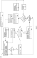
- a vehicle location accuracy enhancement system flow diagram 300 of an example embodiment is illustrated.
- the vehicle location accuracy enhancement system flow diagram 300 is provided as series of sequential blocks.
- the sequence of the block may be different in other embodiments and may even occur in parallel with each other. Hence, embodiments are not limited to the sequence of blocks set out in Figure 3 .
- the process of the vehicle location accuracy enhancement system flow diagram 300 starts at block (301) where a profiled terrain 204 is generated using a digital active phased array radar that includes altitude information.
- the profiled terrain 204 using the DAPA 132 is compared to stored terrain altitude information in the terrain database 108. If there is no match detected at block (304), the process continues at block (302) comparing the profiled terrain 204 with the stored terrain in the terrain database 108. If there is a match detected at block (304), a location or location solution of the vehicle based on the match is determined at block (306).
- the system uses the location solution determined by the DAPA at block (310). This situation may occur when other location determining systems are not working. In this situation, the profiled location solution derived from the DAPA 132 is used. The process then continues at block (302) comparing the profiled terrain 204 with the stored terrain in the terrain database 108.
- the DAPA based location solution (profiled location solution) is compared with the sensor location solution at block (310). It is then determined if there is a difference between the profiled location solution and the sensor location solution at block (311). If there is no difference, the process continues at block (312). In one example embodiment, if there is a difference, it is then determined if the difference is beyond a defined threshold limit at block (312). If the difference is beyond the defined threshold at block (312), an alarm is generated at block (314) and the process continues at block (302). If it is determined at block (312) that the difference is not beyond the defined threshold, a location error with an associated sensor location determining system is determined at block (316).
- a broadcast of the determined location error is provided at block (318). This allows for location determining systems in other vehicles to have notice of the location error with data associate with a location determining system such as, for example, with data in signals in the GNSS receiver 110.
- the process then continues at block (302).
- the sensor location solution may be augmented at block (320) based on the profiled location solution to provide a more accurate location solution.
- the augmented sensor location solution determined at block (320) may then be implemented at block (322). Examples of the implementation include, but are not limited to, using the augmented sensor location solution to display a determined location (position), using the augmented sensor location solution in an automated vehicle control system to control operation of the vehicle, etc.
- the process then continues with block (302) in this example embodiment.
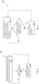
- FIG. 400 Other examples of implementing terrain location solutions are illustrated in a calibrate sensor flow diagram 400 of Figure 4 , an update terrain flow diagram 500 of Figure 5 , an alternative waypoint flow diagram 600 of Figure 6 and in a pattern implemented flow diagram 700 of Figure 7 .
- Each of the flow diagrams 400, 500, 600 and 700 are illustrated as a series of sequential blocks. The sequence of the block may occur in a different order or in parallel in other embodiments. Hence, embodiments are not limited to sequential order illustrated in the flow diagrams.
- the calibrate sensor flow diagram 400 example is illustrated.
- a sensor location solution from one or more sensor location determining systems are compared with the DAPA location solution at block (402). If it is determined there is no difference at block (404), the process continues comparing the sensor location solution with the DAPA location solution at block (402). If it is determined there is a difference at block (404), the system that generated the sensor location solution is calibrated at block (406).
- Calibration may include adjusting an output of a location determining system to match the profile location solution from the DAPA system. The process then continues comparing the sensor location solution with the profiled location solution at block (402).
- the calibrate sensor flow diagram 400 may be used to calibrate any system providing information used in generating a location solution, such as but not limited to, the GNSS receiver 110, the 5G transceiver 117, the INS 116 etc.
- the update terrain flow diagram 500 example of Figure 5 starts by comparing the sensed profiled terrain 204 using the DAPA 132 with the stored terrain in the terrain database 108 at block (502). It is determined at block (504), if any features in the sensed profiled terrain 204 do not correspond to features in the stored terrain. This could occur if the terrain, such as a city in an example, changes over time with the construction and removal of buildings. If it is determined at block (504) that no unknown features are found with the profile terrain the process continues at block (502) comparing the sensed profiled terrain 204 using the DAPA 132 with the stored terrain in the terrain database 108.
- the terrain database 108 is updated to include the one or more unknown features at block (506). This method may also be used to remove features from the terrain database 108 that are no longer present in a then current profiled terrain 204. The process then continues at block (502) comparing a then current profiled terrain 204 using the DAPA 132 with the stored terrain in the terrain database 108. In one example embodiment, one of the other systems used to provide a location solution may be used to confirm the location of the system generating the sensed profiled terrain 204 when a feature is added or removed.
- the alternative waypoint flow diagram 600 of Figure 6 illustrates one way of providing alternate waypoints, in an example embodiment, when a variation in altitude of features in a profiled terrain 204 is not adequate to distinguish a location from other locations.
- the process starts by monitoring altitude solutions in the sensed profiled terrain 204 at block (602). It is determined at block (604) if there is a satisfactory amount of altitude variation in the profiled terrain 204. If it is determined at block (604) there is a satisfactory amount of variation in altitude solutions, the process continues monitoring at block (602). If, however, it is determined at block (604) that there is not sufficient variation in altitude in a profiled terrain 204, alternative waypoints are generated at block (606).
- the alternative waypoints may be used by the vehicle to plot a different travel path that will take the vehicle over terrain that will produce a profiled terrain 204 with sufficient altitude deviations to ensure the sensed profiled terrain 204 is unique enough that when a match is found with stored profiles in the terrain database 108, a determined location of the vehicle can be relied upon.
- the pattern implemented flow diagram 700 of Figure 7 provides an example system that analyses real-time data to find patterns that may help predict location (position) accuracy and prevent failures.
- the process begins at block (702) monitoring location solutions. These are the location solutions from all of the location determining systems of the vehicle including the DAPA generated profiled location solution. It is determined at block (704) if any patterns can be detected from the different location solutions. If no pattern is detected at block (704), the process continues at block (702). If it is determined at block (704) that a pattern is present, it is then determined at block (706) if the pattern can be used to predict accuracy at block (706). If it cannot be used to determine accuracy, the process continues at block (702) monitoring location solutions.
- the controller uses information from the pattern to provide a final location solution at block (708) and the process continues at block (702).
- the then current data including the then current location solutions from the different location determining systems, is passed to the controller 102 which analyzes the real-time data and finds pattern that can help predicting location accuracy and prevent failures.
- the controller 102 implementing the predicting and detecting module 107 of the instructions in memory 104, takes into consideration dynamic behavioral patterns of the contextual data relating to the vehicle's navigation and data from GPS, INS, Terrain DB, 5G cell information, etc. If, for example, the pattern indicates one of the location determining systems is providing location information during certain conditions that is not as accurate as other systems providing location information during those conditions, information from the one location determining system will not be used to provide a final location solution when the condition is experienced.
- input data from systems relating to location enables the controller 102, implementing the instructions in the module 107, to detect anomalies and make determinations on which single or multiple inputs will provide a more accurate navigation location based patterns detected in various earlier data feeds (machine learning).
- the instructions implemented by the controller include regression models that generate predictions and help decide which of the sensor inputs should be blended to give optimal location accuracy at any moment of time.
- an artificial intelligence implemented by the controller 102 based on the instructions in the module 107 may be built into the system in such a way that an altitude profile can be predicted and the expected altitude profile can be checked with real-time DAPA radar altimeter altitude data to compute the then current location.
- learned information from the determined patterns from earlier data feeds are used to augment current sensor location solutions.
Landscapes
- Engineering & Computer Science (AREA)
- Remote Sensing (AREA)
- Radar, Positioning & Navigation (AREA)
- Physics & Mathematics (AREA)
- General Physics & Mathematics (AREA)
- Computer Networks & Wireless Communication (AREA)
- Aviation & Aerospace Engineering (AREA)
- Electromagnetism (AREA)
- Navigation (AREA)
- Position Fixing By Use Of Radio Waves (AREA)
Claims (10)
- System (100) zur Verbesserung einer Fahrzeugstandortgenauigkeit, das System (100) umfassend:mindestens ein Standortbestimmungssystem (110, 116, 117, 112), das dazu konfiguriert ist, Sensorstandortlösungen zu erzeugen;mindestens ein digitales aktives phasengesteuertes Radarsystem (132), das dazu konfiguriert ist, ein profiliertes Gelände zu erzeugen, das Geländehöheninformationen beinhaltet;mindestens einen Speicher (104), um mindestens eine Geländehöhenprofildatenbank (108) und Bedienungsanweisungen (106) zu speichern;mindestens eine Steuerung (102) in Kommunikation mit mindestens einem Standortbestimmungssystem (110, 116, 117, 112), dem einen digitalen aktiven phasengesteuerten Radar (132) und dem mindestens einen Speicher (104), wobei die mindestens eine Steuerung (102) dazu konfiguriert ist, die Bedienungsanweisungen in dem Speicher (104) zu implementieren, um einen Profilabgleich zwischen dem erzeugten profilierten Gelände aus dem mindestens einen digitalen aktiven phasengesteuerten Radar (132) und Geländehöheninformationen in der Geländehöhenprofildatenbank (108) durchzuführen, um profilierte Standortlösungen zu bestimmen, wobei die mindestens eine Steuerung (102) ferner dazu konfiguriert ist, Sensorstandortlösungen von dem mindestens einen Standortbestimmungssystem (110, 116, 117, 112) mit den profilierten Standortlösungen mindestens zu erweitern, um die Genauigkeit der Sensorstandortlösungen zu verbessern; undwobei das mindestens eine Standortbestimmungssystem (110, 116, 117, 112) einen Empfänger (110) eines globalen Navigationssatellitensystems, GNSS, beinhaltet, gekennzeichnet dadurch, dass die mindestens eine Steuerung (102) dazu konfiguriert ist, Standortfehler in dem GNSS (110) auf Basis der profilierten Standortlösungen zu bestimmen, wobei die mindestens eine Steuerung (102) ferner dazu konfiguriert ist, die bestimmten Standortfehler zu übertragen.
- System (100) nach Anspruch 1, wobei die mindestens eine Steuerung (102) ferner dazu konfiguriert ist, die profilierten Standortlösungen zur Navigation zu verwenden, wenn die Sensorstandortlösungen von dem mindestens einen Standortbestimmungssystem (110, 116, 117, 112) nicht verfügbar sind.
- System (100) nach Anspruch 1, wobei das mindestens eine Standortbestimmungssystem (110, 116, 117, 112) ferner eines aus einem Trägheitsnavigationssystem (116), einem 5G-Positionierungssystem (117) und einem verbesserten Bodennähe-Warnsystem (112) beinhaltet.
- System (100) nach Anspruch 3, wobei die mindestens eine Steuerung (102) ferner dazu konfiguriert ist, das mindestens eine Standortbestimmungssystem (110, 116, 117, 112) auf Basis mindestens teilweise der profilierten Positionslösungen zu kalibrieren.
- System (100) nach Anspruch 1, wobei ferner die mindestens eine Steuerung (102) dazu konfiguriert ist, ein Nichtübereinstimmungsalarmsignal zu erzeugen, wenn eine Sensorstandortlösung, die von dem mindestens einen Standortbestimmungssystem erzeugt wird, und eine profilierte Standortlösung, die von dem digitalen aktiven phasengesteuerten Radarsystem erzeugt wird, eine Differenz aufweisen, die größer als ein ausgewählter Grenzwert ist.
- System (100) nach Anspruch 1, wobei ferner die mindestens eine Steuerung (102) dazu konfiguriert ist, alternative Wegpunkte vorherzusagen, falls eine bestimmtes Geländehöhenprofil nicht in einer Größenordnung einer zufriedenstellenden Abweichung liegt, um eine genaue profilierte Standortlösung bereitzustellen.
- System (100) nach Anspruch 1, wobei die mindestens eine Steuerung (102) ferner dazu konfiguriert ist, die profilierten Standortlösungen und die Sensorstandortlösungen in Echtzeit zu analysieren, um Muster zu bestimmen, welche eine Standortgenauigkeit vorhersagen.
- Verfahren zum Verbessern einer Genauigkeit eines Fahrzeugstandortbestimmungssystems (100), das Verfahren umfassend:Erzeugen eines profilierten Geländes (204) unter Verwendung eines digitalen aktiven phasengesteuerten Radars (132), das Höheninformationen beinhaltet;Vergleichen des profilierten Geländes (204) mit Geländehöheninformationen in einer Geländehöhenprofildatenbank (108);Bestimmen einer profilierten Standortlösung, wenn eine Übereinstimmung zwischen dem profilierten Gelände (204) und Geländehöheninformationen in der Geländehöhenprofildatenbank (108) gefunden wird;gekennzeichnet durch Vergleichen der profilierten Standortlösung mit mindestens einer Sensorstandortlösung von einem Empfänger (110) eines globalen Navigationssatellitensystems, GNSS;Bestimmen, ob Standortfehler in der Sensorstandortlösung von dem GNSS-Empfänger (110) vorliegen, auf Basis des Vergleichs der profilierten Standortlösung mit der Sensorstandortlösung von dem GNSS-Empfänger (110); undÜbertragen von bestimmten Standortfehlern.
- Verfahren nach Anspruch 8, ferner umfassend mindestens eines aus Erweitern der Sensorstandortlösung auf Basis der profilierten Standortlösung und Kalibrieren des GNSS-Empfängers (110) auf Basis der profilierten Standortlösung.
- Verfahren nach Anspruch 8, ferner umfassend:Erzeugen von mindestens einer weiteren Sensorstandortlösung von einem anderen Standortbestimmungssystem (110, 116, 117, 112);Überwachen auf Muster in den Sensorstandortlösungen und der Profilstandortlösung; undVerwenden von bestimmten Mustern, um erweiterte Standortlösungen zu erzeugen.
Applications Claiming Priority (2)
| Application Number | Priority Date | Filing Date | Title |
|---|---|---|---|
| IN202111001201 | 2021-01-11 | ||
| US17/190,675 US11914053B2 (en) | 2021-01-11 | 2021-03-03 | Vehicle location accuracy enhancement system |
Publications (2)
| Publication Number | Publication Date |
|---|---|
| EP4027170A1 EP4027170A1 (de) | 2022-07-13 |
| EP4027170B1 true EP4027170B1 (de) | 2024-11-27 |
Family
ID=79185469
Family Applications (1)
| Application Number | Title | Priority Date | Filing Date |
|---|---|---|---|
| EP21218084.8A Active EP4027170B1 (de) | 2021-01-11 | 2021-12-29 | System zur erhöhung der ortungsgenauigkeit eines fahrzeugs |
Country Status (2)
| Country | Link |
|---|---|
| EP (1) | EP4027170B1 (de) |
| CN (1) | CN114755677A (de) |
Families Citing this family (1)
| Publication number | Priority date | Publication date | Assignee | Title |
|---|---|---|---|---|
| FR3158189A1 (fr) * | 2024-01-05 | 2025-07-11 | Airbus Operations (S.A.S.) | Système avionique et procédé de détection d’un arrêt au sol d’un aéronef. |
Citations (1)
| Publication number | Priority date | Publication date | Assignee | Title |
|---|---|---|---|---|
| US20100256840A1 (en) * | 2006-05-22 | 2010-10-07 | Call Curtis J | Methods and systems for radar aided aircraft positioning for approaches and landings |
Family Cites Families (6)
| Publication number | Priority date | Publication date | Assignee | Title |
|---|---|---|---|---|
| US6281832B1 (en) * | 1999-08-31 | 2001-08-28 | Rockwell Collins | Method and apparatus for using statistical data processing in altimeter and terrain awareness integrity monitoring systems |
| US9110170B1 (en) * | 2014-08-29 | 2015-08-18 | Raytheon Company | Terrain aided navigation using multi-channel monopulse radar imaging |
| DE102017211605A1 (de) * | 2017-07-07 | 2019-01-10 | Robert Bosch Gmbh | Verfahren zur Lokalisierung eines höher automatisierten Fahrzeugs (HAF), insbesondere eines hochautomatisierten Fahrzeugs, und ein Fahrerassistenzsystem |
| US10775473B2 (en) * | 2018-04-27 | 2020-09-15 | Cubic Corporation | Correcting location data of connected vehicle |
| GB2575971A (en) * | 2018-07-23 | 2020-02-05 | Atlantic Inertial Systems Ltd | A navigation system |
| US11506512B2 (en) * | 2019-05-22 | 2022-11-22 | TDK Japan | Method and system using tightly coupled radar positioning to improve map performance |
-
2021
- 2021-12-22 CN CN202111585189.1A patent/CN114755677A/zh active Pending
- 2021-12-29 EP EP21218084.8A patent/EP4027170B1/de active Active
Patent Citations (1)
| Publication number | Priority date | Publication date | Assignee | Title |
|---|---|---|---|---|
| US20100256840A1 (en) * | 2006-05-22 | 2010-10-07 | Call Curtis J | Methods and systems for radar aided aircraft positioning for approaches and landings |
Also Published As
| Publication number | Publication date |
|---|---|
| CN114755677A (zh) | 2022-07-15 |
| EP4027170A1 (de) | 2022-07-13 |
Similar Documents
| Publication | Publication Date | Title |
|---|---|---|
| US11914053B2 (en) | Vehicle location accuracy enhancement system | |
| US12306315B2 (en) | GNSS receiver protection levels | |
| Dissanayaka et al. | Review of navigation methods for UAV-based parcel delivery | |
| US10365363B2 (en) | Mobile localization using sparse time-of-flight ranges and dead reckoning | |
| US20170023659A1 (en) | Adaptive positioning system | |
| US20200216076A1 (en) | Method for determining the location of an ego-vehicle | |
| US6512976B1 (en) | Method and system for terrain aided navigation | |
| US20070239326A1 (en) | Systems and methods for monitoring an altitude in a flight vehicle | |
| KR101908534B1 (ko) | 이동체의 위치 및 자세 결정 장치 및 방법 | |
| WO2016196717A2 (en) | Mobile localization using sparse time-of-flight ranges and dead reckoning | |
| US6845304B1 (en) | Method of and system for deriving inertial-aided deviations for autoland systems during GPS signal interruptions | |
| US20190005829A1 (en) | Operation control apparatus of movable body, method of controlling operation of movable body, and computer readable medium | |
| EP4027170A1 (de) | System zur erhöhung der ortungsgenauigkeit eines fahrzeugs | |
| US8798911B2 (en) | Systems and methods for determining bearing | |
| de Ponte Müller et al. | Cooperative infrastructure-based vehicle positioning | |
| Mamchenko et al. | Algorithm for sensor data merging using analytical module for priority sensor selection | |
| US20260087932A1 (en) | Determining a position and an integrity of the position of a vehicle and an integrity of the position of neighboring vehicles using radar and ads-b data | |
| US11313941B2 (en) | Communication device and control method | |
| CN116710909B (zh) | 存储地形数据库的电子装置、生成该数据库的方法、航电系统、监测方法及相关计算机程序 | |
| Renga et al. | Navigation facility for high accuracy offline trajectory and attitude estimation in airborne applications | |
| Liu et al. | Process design and network shape evaluation of multi-target collaborative navigation | |
| KR101921483B1 (ko) | Gnss 기반의 위치 추정의 불확실성을 측정하는 방법 | |
| US20230349701A1 (en) | Method for validating an initial position for positioning a vehicle | |
| EP4718105A1 (de) | Bestimmung einer position und einer integrität der position eines fahrzeugs und integrität der position benachbarter fahrzeuge unter verwendung von radar- und ads-b-daten | |
| US20250157345A1 (en) | Local positioning system for global navigation satellite system denied regions |
Legal Events
| Date | Code | Title | Description |
|---|---|---|---|
| PUAI | Public reference made under article 153(3) epc to a published international application that has entered the european phase |
Free format text: ORIGINAL CODE: 0009012 |
|
| STAA | Information on the status of an ep patent application or granted ep patent |
Free format text: STATUS: THE APPLICATION HAS BEEN PUBLISHED |
|
| AK | Designated contracting states |
Kind code of ref document: A1 Designated state(s): AL AT BE BG CH CY CZ DE DK EE ES FI FR GB GR HR HU IE IS IT LI LT LU LV MC MK MT NL NO PL PT RO RS SE SI SK SM TR |
|
| STAA | Information on the status of an ep patent application or granted ep patent |
Free format text: STATUS: REQUEST FOR EXAMINATION WAS MADE |
|
| 17P | Request for examination filed |
Effective date: 20221014 |
|
| RBV | Designated contracting states (corrected) |
Designated state(s): AL AT BE BG CH CY CZ DE DK EE ES FI FR GB GR HR HU IE IS IT LI LT LU LV MC MK MT NL NO PL PT RO RS SE SI SK SM TR |
|
| P01 | Opt-out of the competence of the unified patent court (upc) registered |
Effective date: 20230421 |
|
| GRAP | Despatch of communication of intention to grant a patent |
Free format text: ORIGINAL CODE: EPIDOSNIGR1 |
|
| STAA | Information on the status of an ep patent application or granted ep patent |
Free format text: STATUS: GRANT OF PATENT IS INTENDED |
|
| INTG | Intention to grant announced |
Effective date: 20240717 |
|
| GRAS | Grant fee paid |
Free format text: ORIGINAL CODE: EPIDOSNIGR3 |
|
| GRAA | (expected) grant |
Free format text: ORIGINAL CODE: 0009210 |
|
| STAA | Information on the status of an ep patent application or granted ep patent |
Free format text: STATUS: THE PATENT HAS BEEN GRANTED |
|
| AK | Designated contracting states |
Kind code of ref document: B1 Designated state(s): AL AT BE BG CH CY CZ DE DK EE ES FI FR GB GR HR HU IE IS IT LI LT LU LV MC MK MT NL NO PL PT RO RS SE SI SK SM TR |
|
| REG | Reference to a national code |
Ref country code: GB Ref legal event code: FG4D |
|
| REG | Reference to a national code |
Ref country code: CH Ref legal event code: EP |
|
| REG | Reference to a national code |
Ref country code: IE Ref legal event code: FG4D |
|
| REG | Reference to a national code |
Ref country code: DE Ref legal event code: R096 Ref document number: 602021022367 Country of ref document: DE |
|
| REG | Reference to a national code |
Ref country code: LT Ref legal event code: MG9D |
|
| REG | Reference to a national code |
Ref country code: NL Ref legal event code: MP Effective date: 20241127 |
|
| PG25 | Lapsed in a contracting state [announced via postgrant information from national office to epo] |
Ref country code: PT Free format text: LAPSE BECAUSE OF FAILURE TO SUBMIT A TRANSLATION OF THE DESCRIPTION OR TO PAY THE FEE WITHIN THE PRESCRIBED TIME-LIMIT Effective date: 20250327 Ref country code: IS Free format text: LAPSE BECAUSE OF FAILURE TO SUBMIT A TRANSLATION OF THE DESCRIPTION OR TO PAY THE FEE WITHIN THE PRESCRIBED TIME-LIMIT Effective date: 20250327 Ref country code: HR Free format text: LAPSE BECAUSE OF FAILURE TO SUBMIT A TRANSLATION OF THE DESCRIPTION OR TO PAY THE FEE WITHIN THE PRESCRIBED TIME-LIMIT Effective date: 20241127 |
|
| PG25 | Lapsed in a contracting state [announced via postgrant information from national office to epo] |
Ref country code: FI Free format text: LAPSE BECAUSE OF FAILURE TO SUBMIT A TRANSLATION OF THE DESCRIPTION OR TO PAY THE FEE WITHIN THE PRESCRIBED TIME-LIMIT Effective date: 20241127 Ref country code: NL Free format text: LAPSE BECAUSE OF FAILURE TO SUBMIT A TRANSLATION OF THE DESCRIPTION OR TO PAY THE FEE WITHIN THE PRESCRIBED TIME-LIMIT Effective date: 20241127 |
|
| REG | Reference to a national code |
Ref country code: AT Ref legal event code: MK05 Ref document number: 1746196 Country of ref document: AT Kind code of ref document: T Effective date: 20241127 |
|
| PG25 | Lapsed in a contracting state [announced via postgrant information from national office to epo] |
Ref country code: BG Free format text: LAPSE BECAUSE OF FAILURE TO SUBMIT A TRANSLATION OF THE DESCRIPTION OR TO PAY THE FEE WITHIN THE PRESCRIBED TIME-LIMIT Effective date: 20241127 |
|
| PG25 | Lapsed in a contracting state [announced via postgrant information from national office to epo] |
Ref country code: ES Free format text: LAPSE BECAUSE OF FAILURE TO SUBMIT A TRANSLATION OF THE DESCRIPTION OR TO PAY THE FEE WITHIN THE PRESCRIBED TIME-LIMIT Effective date: 20241127 |
|
| PG25 | Lapsed in a contracting state [announced via postgrant information from national office to epo] |
Ref country code: NO Free format text: LAPSE BECAUSE OF FAILURE TO SUBMIT A TRANSLATION OF THE DESCRIPTION OR TO PAY THE FEE WITHIN THE PRESCRIBED TIME-LIMIT Effective date: 20250227 |
|
| PG25 | Lapsed in a contracting state [announced via postgrant information from national office to epo] |
Ref country code: GR Free format text: LAPSE BECAUSE OF FAILURE TO SUBMIT A TRANSLATION OF THE DESCRIPTION OR TO PAY THE FEE WITHIN THE PRESCRIBED TIME-LIMIT Effective date: 20250228 Ref country code: LV Free format text: LAPSE BECAUSE OF FAILURE TO SUBMIT A TRANSLATION OF THE DESCRIPTION OR TO PAY THE FEE WITHIN THE PRESCRIBED TIME-LIMIT Effective date: 20241127 Ref country code: AT Free format text: LAPSE BECAUSE OF FAILURE TO SUBMIT A TRANSLATION OF THE DESCRIPTION OR TO PAY THE FEE WITHIN THE PRESCRIBED TIME-LIMIT Effective date: 20241127 |
|
| PG25 | Lapsed in a contracting state [announced via postgrant information from national office to epo] |
Ref country code: PL Free format text: LAPSE BECAUSE OF FAILURE TO SUBMIT A TRANSLATION OF THE DESCRIPTION OR TO PAY THE FEE WITHIN THE PRESCRIBED TIME-LIMIT Effective date: 20241127 |
|
| PG25 | Lapsed in a contracting state [announced via postgrant information from national office to epo] |
Ref country code: RS Free format text: LAPSE BECAUSE OF FAILURE TO SUBMIT A TRANSLATION OF THE DESCRIPTION OR TO PAY THE FEE WITHIN THE PRESCRIBED TIME-LIMIT Effective date: 20250227 |
|
| REG | Reference to a national code |
Ref country code: DE Ref legal event code: R119 Ref document number: 602021022367 Country of ref document: DE |
|
| PG25 | Lapsed in a contracting state [announced via postgrant information from national office to epo] |
Ref country code: SM Free format text: LAPSE BECAUSE OF FAILURE TO SUBMIT A TRANSLATION OF THE DESCRIPTION OR TO PAY THE FEE WITHIN THE PRESCRIBED TIME-LIMIT Effective date: 20241127 |
|
| PG25 | Lapsed in a contracting state [announced via postgrant information from national office to epo] |
Ref country code: DK Free format text: LAPSE BECAUSE OF FAILURE TO SUBMIT A TRANSLATION OF THE DESCRIPTION OR TO PAY THE FEE WITHIN THE PRESCRIBED TIME-LIMIT Effective date: 20241127 |
|
| PG25 | Lapsed in a contracting state [announced via postgrant information from national office to epo] |
Ref country code: EE Free format text: LAPSE BECAUSE OF FAILURE TO SUBMIT A TRANSLATION OF THE DESCRIPTION OR TO PAY THE FEE WITHIN THE PRESCRIBED TIME-LIMIT Effective date: 20241127 |
|
| PG25 | Lapsed in a contracting state [announced via postgrant information from national office to epo] |
Ref country code: RO Free format text: LAPSE BECAUSE OF FAILURE TO SUBMIT A TRANSLATION OF THE DESCRIPTION OR TO PAY THE FEE WITHIN THE PRESCRIBED TIME-LIMIT Effective date: 20241127 |
|
| PG25 | Lapsed in a contracting state [announced via postgrant information from national office to epo] |
Ref country code: SK Free format text: LAPSE BECAUSE OF FAILURE TO SUBMIT A TRANSLATION OF THE DESCRIPTION OR TO PAY THE FEE WITHIN THE PRESCRIBED TIME-LIMIT Effective date: 20241127 |
|
| PG25 | Lapsed in a contracting state [announced via postgrant information from national office to epo] |
Ref country code: CZ Free format text: LAPSE BECAUSE OF FAILURE TO SUBMIT A TRANSLATION OF THE DESCRIPTION OR TO PAY THE FEE WITHIN THE PRESCRIBED TIME-LIMIT Effective date: 20241127 |
|
| PG25 | Lapsed in a contracting state [announced via postgrant information from national office to epo] |
Ref country code: IT Free format text: LAPSE BECAUSE OF FAILURE TO SUBMIT A TRANSLATION OF THE DESCRIPTION OR TO PAY THE FEE WITHIN THE PRESCRIBED TIME-LIMIT Effective date: 20241127 |
|
| REG | Reference to a national code |
Ref country code: CH Ref legal event code: PL |
|
| PG25 | Lapsed in a contracting state [announced via postgrant information from national office to epo] |
Ref country code: LU Free format text: LAPSE BECAUSE OF NON-PAYMENT OF DUE FEES Effective date: 20241229 |
|
| PG25 | Lapsed in a contracting state [announced via postgrant information from national office to epo] |
Ref country code: SE Free format text: LAPSE BECAUSE OF FAILURE TO SUBMIT A TRANSLATION OF THE DESCRIPTION OR TO PAY THE FEE WITHIN THE PRESCRIBED TIME-LIMIT Effective date: 20241127 |
|
| PG25 | Lapsed in a contracting state [announced via postgrant information from national office to epo] |
Ref country code: MC Free format text: LAPSE BECAUSE OF FAILURE TO SUBMIT A TRANSLATION OF THE DESCRIPTION OR TO PAY THE FEE WITHIN THE PRESCRIBED TIME-LIMIT Effective date: 20241127 |
|
| PLBE | No opposition filed within time limit |
Free format text: ORIGINAL CODE: 0009261 |
|
| STAA | Information on the status of an ep patent application or granted ep patent |
Free format text: STATUS: NO OPPOSITION FILED WITHIN TIME LIMIT |
|
| REG | Reference to a national code |
Ref country code: BE Ref legal event code: MM Effective date: 20241231 |
|
| PG25 | Lapsed in a contracting state [announced via postgrant information from national office to epo] |
Ref country code: DE Free format text: LAPSE BECAUSE OF NON-PAYMENT OF DUE FEES Effective date: 20250701 |
|
| PG25 | Lapsed in a contracting state [announced via postgrant information from national office to epo] |
Ref country code: BE Free format text: LAPSE BECAUSE OF NON-PAYMENT OF DUE FEES Effective date: 20241231 |
|
| PG25 | Lapsed in a contracting state [announced via postgrant information from national office to epo] |
Ref country code: CH Free format text: LAPSE BECAUSE OF NON-PAYMENT OF DUE FEES Effective date: 20241231 |
|
| PG25 | Lapsed in a contracting state [announced via postgrant information from national office to epo] |
Ref country code: IE Free format text: LAPSE BECAUSE OF NON-PAYMENT OF DUE FEES Effective date: 20241229 |
|
| 26N | No opposition filed |
Effective date: 20250828 |
|
| PGFP | Annual fee paid to national office [announced via postgrant information from national office to epo] |
Ref country code: FR Payment date: 20251223 Year of fee payment: 5 |
|
| PG25 | Lapsed in a contracting state [announced via postgrant information from national office to epo] |
Ref country code: CY Free format text: LAPSE BECAUSE OF FAILURE TO SUBMIT A TRANSLATION OF THE DESCRIPTION OR TO PAY THE FEE WITHIN THE PRESCRIBED TIME-LIMIT Effective date: 20241127 |