EP4026663B1 - Navigation eines tele-roboters in einer dynamischen umgebung mittels in-situ-intelligenz - Google Patents
Navigation eines tele-roboters in einer dynamischen umgebung mittels in-situ-intelligenz Download PDFInfo
- Publication number
- EP4026663B1 EP4026663B1 EP21161405.2A EP21161405A EP4026663B1 EP 4026663 B1 EP4026663 B1 EP 4026663B1 EP 21161405 A EP21161405 A EP 21161405A EP 4026663 B1 EP4026663 B1 EP 4026663B1
- Authority
- EP
- European Patent Office
- Prior art keywords
- centric
- robot
- tele
- geo
- map
- Prior art date
- Legal status (The legal status is an assumption and is not a legal conclusion. Google has not performed a legal analysis and makes no representation as to the accuracy of the status listed.)
- Active
Links
Images


Classifications
-
- B—PERFORMING OPERATIONS; TRANSPORTING
- B25—HAND TOOLS; PORTABLE POWER-DRIVEN TOOLS; MANIPULATORS
- B25J—MANIPULATORS; CHAMBERS PROVIDED WITH MANIPULATION DEVICES
- B25J9/00—Program-controlled manipulators
- B25J9/16—Program controls
- B25J9/1679—Program controls characterised by the tasks executed
- B25J9/1689—Teleoperation
-
- B—PERFORMING OPERATIONS; TRANSPORTING
- B25—HAND TOOLS; PORTABLE POWER-DRIVEN TOOLS; MANIPULATORS
- B25J—MANIPULATORS; CHAMBERS PROVIDED WITH MANIPULATION DEVICES
- B25J13/00—Controls for manipulators
- B25J13/08—Controls for manipulators by means of sensing devices, e.g. viewing or touching devices
- B25J13/088—Controls for manipulators by means of sensing devices, e.g. viewing or touching devices with position, velocity or acceleration sensors
- B25J13/089—Determining the position of the robot with reference to its environment
-
- B—PERFORMING OPERATIONS; TRANSPORTING
- B25—HAND TOOLS; PORTABLE POWER-DRIVEN TOOLS; MANIPULATORS
- B25J—MANIPULATORS; CHAMBERS PROVIDED WITH MANIPULATION DEVICES
- B25J3/00—Manipulators of leader-follower type, i.e. both controlling unit and controlled unit perform corresponding spatial movements
-
- B—PERFORMING OPERATIONS; TRANSPORTING
- B25—HAND TOOLS; PORTABLE POWER-DRIVEN TOOLS; MANIPULATORS
- B25J—MANIPULATORS; CHAMBERS PROVIDED WITH MANIPULATION DEVICES
- B25J9/00—Program-controlled manipulators
- B25J9/16—Program controls
- B25J9/1602—Program controls characterised by the control system, structure, architecture
- B25J9/161—Hardware, e.g. neural networks, fuzzy logic, interfaces, processor
-
- B—PERFORMING OPERATIONS; TRANSPORTING
- B25—HAND TOOLS; PORTABLE POWER-DRIVEN TOOLS; MANIPULATORS
- B25J—MANIPULATORS; CHAMBERS PROVIDED WITH MANIPULATION DEVICES
- B25J9/00—Program-controlled manipulators
- B25J9/16—Program controls
- B25J9/1628—Program controls characterised by the control loop
- B25J9/163—Program controls characterised by the control loop learning, adaptive, model based, rule based expert control
-
- B—PERFORMING OPERATIONS; TRANSPORTING
- B25—HAND TOOLS; PORTABLE POWER-DRIVEN TOOLS; MANIPULATORS
- B25J—MANIPULATORS; CHAMBERS PROVIDED WITH MANIPULATION DEVICES
- B25J9/00—Program-controlled manipulators
- B25J9/16—Program controls
- B25J9/1656—Program controls characterised by programming, planning systems for manipulators
- B25J9/1664—Program controls characterised by programming, planning systems for manipulators characterised by motion, path, trajectory planning
- B25J9/1666—Avoiding collision or forbidden zones
-
- B—PERFORMING OPERATIONS; TRANSPORTING
- B25—HAND TOOLS; PORTABLE POWER-DRIVEN TOOLS; MANIPULATORS
- B25J—MANIPULATORS; CHAMBERS PROVIDED WITH MANIPULATION DEVICES
- B25J9/00—Program-controlled manipulators
- B25J9/16—Program controls
- B25J9/1694—Program controls characterised by use of sensors other than normal servo-feedback from position, speed or acceleration sensors, perception control, multi-sensor controlled systems, sensor fusion
- B25J9/1697—Vision controlled systems
-
- G—PHYSICS
- G05—CONTROLLING; REGULATING
- G05D—SYSTEMS FOR CONTROLLING OR REGULATING NON-ELECTRIC VARIABLES
- G05D1/00—Control of position, course, altitude or attitude of land, water, air or space vehicles, e.g. using automatic pilots
- G05D1/0011—Control of position, course, altitude or attitude of land, water, air or space vehicles, e.g. using automatic pilots associated with a remote control arrangement
- G05D1/0038—Control of position, course, altitude or attitude of land, water, air or space vehicles, e.g. using automatic pilots associated with a remote control arrangement by providing the operator with simple or augmented images from one or more cameras located onboard the vehicle, e.g. tele-operation
-
- G—PHYSICS
- G05—CONTROLLING; REGULATING
- G05D—SYSTEMS FOR CONTROLLING OR REGULATING NON-ELECTRIC VARIABLES
- G05D1/00—Control of position, course, altitude or attitude of land, water, air or space vehicles, e.g. using automatic pilots
- G05D1/02—Control of position or course in two dimensions
- G05D1/021—Control of position or course in two dimensions specially adapted to land vehicles
- G05D1/0268—Control of position or course in two dimensions specially adapted to land vehicles using internal positioning means
- G05D1/0274—Control of position or course in two dimensions specially adapted to land vehicles using internal positioning means using mapping information stored in a memory device
-
- G—PHYSICS
- G05—CONTROLLING; REGULATING
- G05B—CONTROL OR REGULATING SYSTEMS IN GENERAL; FUNCTIONAL ELEMENTS OF SUCH SYSTEMS; MONITORING OR TESTING ARRANGEMENTS FOR SUCH SYSTEMS OR ELEMENTS
- G05B2219/00—Program-control systems
- G05B2219/30—Nc systems
- G05B2219/35—Nc in input of data, input till input file format
- G05B2219/35472—Mode selection
-
- G—PHYSICS
- G05—CONTROLLING; REGULATING
- G05B—CONTROL OR REGULATING SYSTEMS IN GENERAL; FUNCTIONAL ELEMENTS OF SUCH SYSTEMS; MONITORING OR TESTING ARRANGEMENTS FOR SUCH SYSTEMS OR ELEMENTS
- G05B2219/00—Program-control systems
- G05B2219/30—Nc systems
- G05B2219/39—Robotics, robotics to robotics hand
- G05B2219/39212—Select between autonomous or teleoperation control
-
- G—PHYSICS
- G05—CONTROLLING; REGULATING
- G05B—CONTROL OR REGULATING SYSTEMS IN GENERAL; FUNCTIONAL ELEMENTS OF SUCH SYSTEMS; MONITORING OR TESTING ARRANGEMENTS FOR SUCH SYSTEMS OR ELEMENTS
- G05B2219/00—Program-control systems
- G05B2219/30—Nc systems
- G05B2219/40—Robotics, robotics mapping to robotics vision
- G05B2219/40174—Robot teleoperation through internet
Definitions
- the disclosure herein generally relates to navigation of a tele-robot, and, more particularly, to navigation of a tele-robot in dynamic environment using in-situ intelligence.
- Tele-robotics is the area of robotics concerned with the control of robots from a distance, primarily using a wireless network/wireless communication such as a Wi-Fi, a Bluetooth, a deep space network, and similar or tethered connections.
- a user aka master
- a robot aka avatar or tele-robot
- the master and the tele-robot are connected over a public internet infrastructure, wherein the master sends commands to the tele-robot based on visual feedback from the tele-robot.
- Telepresence robots are being used in a wide variety of other applications ranging from medicine to toxic waste cleanup to art installations.
- One of the major tasks for the master is to guide the tele-robot to navigate through a remote environment/geography.
- the navigation can happen either (a) in a manual mode, or (b) in an autonomous mode.
- the manual mode of navigation is tedious for the master as it needs frequent transmission of kinematic control information over a network which may not be efficient in terms of communication resource usage.
- Further in the autonomous mode of navigation there is an increased probability of service disruption due to loss of control commands because of transient impairments in the end-to-end channel. Hence a hybrid mode of communication is preferable.
- the remote environment where the tele robot navigates may be dynamic in nature as there may be unpredictable movements or positioning of objects obstructing the estimated trajectory that the tele-robotics might take to reach the end-destination.
- the tele-robot must be equipped with intelligence to understand the dynamic environment accurately despite the dynamic variance in the context while on move by not completely depending on the master's command.
- US 2009/234499 A1 discloses systems, methods, and user interfaces are used for controlling a robot.
- An environment map and a robot designator are presented to a user.
- the user may place, move, and modify task designators on the environment map.
- the task designators indicate a position in the environment map and indicate a task for the robot to achieve.
- a control intermediary links task designator with robot instructions issued to the robot.
- the control intermediary analyzes a relative position between the task designators and the robot.
- the control intermediary uses the analysis to determine a task-oriented autonomy level for the robot and communicates target achievement information to the robot.
- the target achievement information may include instructions for directly guiding the robot if the autonomy level indicates low robot initiative and may include instructions for directing the robot to determine a robot plan for achieving the task if the autonomy level indicates high robot initiative.
- WO 2017/211031 A1 discloses an unmanned aerial vehicle mechanical arm control method and device, the method comprising: wearable sensing equipment (41) obtaining arm motion information and sending said motion information to a first controller (42), and the first controller (42) generating a control command by filtering and encoding the motion information and sending the control command to a wireless transmitter (43) of a terminal; the wireless transmitter (43) of the terminal sending said control instruction to an unmanned aerial vehicle, a second controller (44) of the unmanned aerial vehicle decoding the control instruction so as to obtain control information, and a mechanical arm (45) of the unmanned aerial vehicle moving according to the control information.
- Embodiments of the present disclosure present technological improvements as solutions to one or more of the above-mentioned technical problems recognized by the inventors in conventional systems.
- a method for navigation of a tele-robot in dynamic environment using in-situ intelligence is provided according to claim 1.
- a system for navigation of a tele-robot in dynamic environment using in-situ intelligence is provided according to claim 8.
- a non-transitory computer-readable medium is provided according to claim 10.
- Tele-robotics is the area of robotics concerned with the control of robots from a distance or a remote location. Telepresence robots are being used in a wide variety of other applications ranging from medicine to toxic waste cleanup to art installations.
- the tele-robotics system comprises of a master and atleast one tele-robot, wherein the tele-robot is located at a remote location away from the master.
- the master and the tele-robot primarily to communicate using a wireless network/wireless communication such as a Wi-Fi, a Bluetooth, a deep space network, and similar or tethered connections.
- the master and the tele-robot are connected over a public internet infrastructure, wherein the master sends commands to the tele-robot based on visual feedback from the tele-robot.
- the master and the tele-robot communicate by application messages:
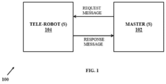
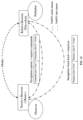
- FIG. 1 An example scenario of the two way communication between a tele-robot 104 and a master is illustrated in FIG. 1 .
- the system 100 of FIG. 1 comprises of a master 102 and at least a telerobot 104.
- the two way communication between a tele-robot 104 and a master 102 is implemented by atleast on request message (from the master 102 to the tele-robot 104) and a plurality of response message (from the tele-robot 104 to the master 102).
- FIG.2 through FIG. 12 where similar reference characters denote corresponding features consistently throughout the figures, there are shown preferred embodiments and these embodiments are described in the context of the following exemplary system and/or method.
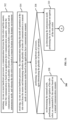
- FIG.2 is a functional block diagram of a system 200 for the navigation of a tele-robot 104 in dynamic environment using in-situ intelligence in accordance with some embodiments of the present disclosure.
- the system 200 is present within the master 102 and the telerobot 104 as shown in FIG. 1 .
- the system 200 includes a processor(s) 204, communication interface device(s), alternatively referred as input/output (I/O) interface(s) 206, and one or more data storage devices or a memory 202 operatively coupled to the processor(s) 204.
- the system 200 with one or more hardware processors is configured to execute functions of one or more functional blocks of the system 200.
- the processor(s) 204 can be one or more hardware processors 204.
- the one or more hardware processors 204 can be implemented as one or more microprocessors, microcomputers, microcontrollers, digital signal processors, central processing units, state machines, logic circuitries, and/or any devices that manipulate signals based on operational instructions.
- the one or more hardware processors 204 is configured to fetch and execute computer-readable instructions stored in the memory 202.
- the system 200 can be implemented in a variety of computing systems including laptop computers, notebooks, hand-held devices such as mobile phones, workstations, mainframe computers, servers, a network cloud and the like.
- the I/O interface(s) 206 can include a variety of software and hardware interfaces, for example, a web interface, a graphical user interface, a touch user interface (TUI) and the like and can facilitate multiple communications within a wide variety of networks N/W and protocol types, including wired networks, for example, LAN, cable, etc., and wireless networks, such as WLAN, cellular, or satellite.
- the I/O interface (s) 206 can include one or more ports for connecting a number of devices (nodes) of the system 200 to one another or to another server.
- the memory 202 may include any computer-readable medium known in the art including, for example, volatile memory, such as static random access memory (SRAM) and dynamic random access memory (DRAM), and/or non-volatile memory, such as read only memory (ROM), erasable programmable ROM, flash memories, hard disks, optical disks, and magnetic tapes.
- volatile memory such as static random access memory (SRAM) and dynamic random access memory (DRAM)
- DRAM dynamic random access memory
- non-volatile memory such as read only memory (ROM), erasable programmable ROM, flash memories, hard disks, optical disks, and magnetic tapes.
- the memory 202 may include a database 208.
- the memory 202 may comprise information pertaining to input(s)/output(s) of each step performed by the processor(s) 204 of the system 200 and methods of the present disclosure.
- the database 208 may be external (not shown) to the system 200 and coupled to the system via the I/O interface 206. Functions of the components of system 200 are explained in conjunction with the flow diagram of FIG.3A , FIG.3B and FIG.3C for the navigation of a tele-robot 104 in dynamic environment using in-situ intelligence.
- the system 200 supports various connectivity options such as BLUETOOTH ® , USB ® , ZigBee ® and other cellular services.
- the network environment enables connection of various components of the system 200 using any communication link including Internet, WAN, MAN, and so on.
- the system 200 is implemented to operate as a stand-alone device.
- the system 200 may be implemented to work as a loosely coupled device to a smart computing environment. The components and functionalities of the system 200 are described further in detail.
- various modules of the system 200 are configured to enable the navigation of a tele-robot 104 in dynamic environment using in-situ intelligence.
- the system 200 is configured for initiating a communication between the tele-robot 104 and the master 102, where the communication is based on an application layer communication semantic.
- the communication is associated with a plurality of modes of operation that includes a manual mode and an autonomous mode, and wherein the tele-robot 104 is located at a remote location in the dynamic environment.
- the system 200 is configured for receiving the communication regarding the mode of operation at the tele-robot 104 from the master 102, wherein the modes of operation is a manual mode or an autonomous mode.
- the various modules of the system 200 for the navigation of a tele-robot 104 in dynamic environment using in-situ intelligence are implemented as at least one of a logically self-contained part of a software program, a self-contained hardware component, and/or, a self-contained hardware component with a logically self-contained part of a software program embedded into each of the hardware component that when executed perform the above method described herein.
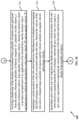
- FIG.3A , FIG.3B and FIG.3C are an exemplary flow diagram illustrating a method 300 for using the system 200 of FIG.2 according to an embodiment of the present disclosure.
- a communication is initiated between the tele-robot 104 and the master 102, via one or more hardware processors 104, wherein the tele-robot 104 is located at a remote location in the dynamic environment.
- the communication is based on an application layer communication semantic.
- the communication is associated with a plurality of modes of operation.
- the plurality of modes of operation includes a manual mode and an autonomous mode.
- the manual mode of operation of the tele-robot 104 completely depends on a set of instructions to be shared by the master 102, whereas the autonomous mode of operation of the tele-robot 104 enables the tele-robot 104 to take its own decisions based on its own intelligence without any intervention/instructions from the master 102.
- the communication is a semi-persistent real-time communication involving a broker-less, peer-to-peer, observer-producer relationship between the master 102 and the tele-robot 104.
- broker-less signifies that there is no intermediate entity, between the master 102 and the tele-robot 104, acting as broker to register each request from master 102 as an independent topic of interest and responses from the tele-robot 104 corresponding to a particular request and, on the other hand, store the responses published by the tele-robot 104.
- peer-to-peer indicated the master 102 and the tele-robot 104 communicate over a direct packet-data channel without requiring an intermediate session manager to enable the exchange over the Internet.
- the observer-producer wherein after each plurality of modes of operation ( manual or automatic), the master 102 initiates a semi-persistent logical connection where a master 102 node of the master 102 becomes an observer observing the state of the tele-robot 104 on the move and the tele-robot 104 becomes a publisher/producer periodically updating its status.
- the application layer communication semantic comprises an application-layer message exchange protocol between the tele-robot 104 and the master 102 that includes a request message from the master 102 to the tele-robot 104 and a plurality of response messages from the tele-robot 104 to the master 102, wherein an application-layer message includes binary representations of a type and a corresponding value for each type.
- the request messages indicate whether the communication/message is for a point goal instruction or for a general kinematic command, while in a special case the request message can indicate an urgent interrupt to stop the process in whatever state it is.
- Table 1 An example packet structure for a request message.
- Command_type (1 byte)
- Command_value (0 - 4 bytes)
- an example scenario of a possible command_type and command_value interpretations are as shown in Table 2 below : Table 2: Command_type and command_value interpretations Command_type Command_value 0x00 Kinematics control indicator (numeric values representing fwd, bkwd, right rotate, left rotate, etc.) 0x01 Represents the destination (x,y) coordinates 0x02 Reserved 0x03 Interrupt to stop the operation. 0x04 - 0xFF Reserved
- an example scenario of possible response_type and response _value interpretations are as shown in Table 4 below : Table 4 : Response_type and response _value interpretations.
- Response_type Response_value 00 Live odometry 01 Destination reached 10 Reserved 11 Aborting
- the above messages can be transferred over any underlying transport having transport level acknowledgement.
- exemplary case may be the WebRTC (Real-Time Communication for the Web) data channel running on SCTP (Stream Control Transmission Protocol) or a CoAP (Constrained Application Protocol) with CON (Confirmable) mode.
- the underlying transport can use any custom mechanism on TCP (Transmission ControlProtocol) or QUIC (Quick UDP Internet Connections) where UDP is abbreviation for User Datagram Protocol, etc.
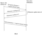
- FIG.4 and FIG.5 illustrates an application layer communication semantic between the tele-robot 104 and the master 102.
- the FIG.4 is an exemplary example of a handshake for a graceful command termination between the tele-robot 104 and the master 102.
- the FIG.5 is an exemplary example of termination initiated by the master 102.
- Each request from the master 102 initiates an Observer-Publisher relationship between the master 102 and the tele-robot 104 where the master 102 becomes an observer and the tele-robot 104 becomes a publisher.
- the master 102 keeps on observing the state of the ongoing execution of the command as published by the tele-robot 104 periodically as responses.
- the responses may contain in instantaneous odometer reading of the tele-robot 104 or it may indicate the end of execution of the request.
- the end of execution may be due to successful completion of the command in the request as shown in FIG.4 or may be due to preemptive termination.
- the preemption may happen due to either proactive termination command by the master 102 based on inference of the remote context through the video feed from the tele-robot 104, or may be due to in situ decision to terminate a task by the tele-robot 104 itself, while the later may happen due to many possible causes like mechanical failure, depletion of battery, etc.
- step 304 of the method (300) receiving the communication regarding the mode of operation at the tele-robot 104 from the master 102 via one or more hardware processors. Further determining whether the plurality of modes of communication is a manual mode or an autonomous mode based on the content of the 1 st byte of the request packet as shown in Table 1. If the byte is 0x00 then it is interpreted by the tele-robot 104 that the request contains manual navigation instruction and the next bytes are interpreted to contain granular movement commands. If the byte contains 0x01 then the tele-robot 104 interprets the request to contain auto-navigation instruction and the next bytes contain the binary representation of the (x, y) coordinate of the desired destination indicated by the master 102 in the remote video.
- step 306 of the method (300) upon determining the plurality of modes of operation, performing one of:
- the manual communication semantic technique comprises a granular step by step navigation request sent to the tele-robot 104 by the master 102 based on a video feed response shared by the tele-robot 104 with the master 102.
- the granular step by step commands depends on specific application. For example, the value 0x01 may indicate "forward move”, 0x02 may indicate “backward move”, 0x03 may indicate “rotate right”, 0x04 may indicate “rotate left”, etc. The exact distance covered in each granular movement is application dependent.
- step 310 of the method (300) performing the in-situ intelligent navigation of the tele-robot 104, comprising several steps that are depicted in FIG.3B and FIG.3C .
- the in-situ intelligent navigation refers to the tele-robot 104 moving to a specific destination by sensing and inferring the environment and deciding the trajectory to reach the destination through its own intelligence as configured by the disclosed method.
- the plurality of objects comprises of a plurality of static objects, a plurality of interactive objects and a plurality of dynamic objects.
- the interactive object is an object navigates/moves by application of an external force and the dynamic object navigates/moves without the external force with a linear velocity (D) and an angular velocity (T)
- an interactive object is a chair, a table, a curtain, a cycle and a car all of which cannot move by itself but can move/navigate by application of an external force.
- a dynamic object are a bird, an animal or a human, all of which navigates/moves by itself (at its own will) without the external force with a linear velocity (D) and an angular velocity (T).
- a sample depth map has been shared in the FIG.6 , wherein the depth map comprises of a plurality of static objects, a plurality of interactive objects and a plurality of dynamic objects.
- a current position of the tele-robot 104 is estimated based on a Simultaneous localization and mapping (SLAM) technique using a velocity associated with the tele-robot 104, wherein the velocity of the tele-robot 104 is obtained using a plurality of sensors and the velocity includes an angular velocity and a linear velocity.
- SLAM Simultaneous localization and mapping
- the Simultaneous localization and mapping (SLAM) technique includes an active neural SLAM technique.
- the plurality of sensors includes a red green and blue (RGB) camera, an odometer and a depth sensor.
- RGB red green and blue
- the velocity of the tele-robot 104 is obtained using a odometer.
- a geo-centric top view map is generated from the depth map using the current position of the tele-robot 104 based on a spatial transform (ST) technique, wherein the geo-centric top view map is a geo-centric representation comprising the current position of the tele-robot 104 and the location details of the plurality of objects.
- ST spatial transform
- the depth map is converted to an ego map which is a top view of the depth map.
- the ego map is then projected at the current location of the robot using Spatial Transformation(ST) which then updates the geocentric map.
- ST Spatial Transformation
- the ego map which is a top view of the depth map is illustrated in FIG.7A and the geocentric map is illustrated in FIG.7B .
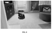
- a video feed of the dynamic environment is received at the tele-robot 104 using the plurality of sensors, wherein the video feed is in RGB format.
- a RCB format image has been illustrated in black and white format in FIG. 8 .
- the plurality of interactive objects and the plurality of dynamic objects are identified in the video feed based on an object detection technique.
- object detection technique includes You Only Look Once (YOLO TM ) object detection techniques, Single Shot Detector (SSD), Spatial Pyramid Pooling (SPP-net), Fast R- Convolutional neural network (CNN) and Faster R-CNN etc., At step 322 of the method (300), estimating upon identifying the object, one of :
- FIG.9 wherein the flowchart illustrates steps for estimating an interactive object position, which is explained below :
- step 902 of the method (900) generating an ego centric projection of the interactive object in the geo-centric map based on a depth segmentation technique.
- the segmentation technique involves segregation of the depth map of the interactive object from the rest of the depth map by overlaying it on top of the object detection bounding box and only taking the pixels inside the box. Since the depth values for the obstacle is different from the background, because the obstacle is closer to the camera than a background, a threshold of depth values gives the exact outline of the interactive object in the depth map. The depth values obtained inside this outline is then projected in the geocentric map using the Spatial Transformation technique.
- step 904 of the method (900) passing the ego centric projection of the interactive object from the ego-centric map in a Spatial Transform (ST) to obtain a geo centric representation of the interactive object by using the velocity, wherein the geo centric representation is the interactive object position.
- ST Spatial Transform
- FIG. 10 wherein the flowchart illustrates steps for estimating a future position of the dynamic object in the geo-centric map on determining the dynamic object, based on a future position estimation technique using a motion model.
- step 1002 of the method (1000) generating an ego centric projection of the dynamic object in the geo-centric map based on a depth segmentation technique
- the segmentation technique involves segregation of the depth map of the dynamic object from the rest of the depth map by overlaying it on top of the dynamic object detection bounding box and only taking the pixels inside the box. Since the depth values for the obstacle is different from the background, because the dynamic object is closer to the camera than a background, a threshold of depth values gives the exact outline of the dynamic object in the depth map. The depth values obtained inside this outline is then projected in the geocentric map using the Spatial Transformation technique.
- step 1004 of the method (1000) obtaining a geo centric representation of the dynamic object by passing the ego-centric map in a Spatial Transform (ST) using the velocity.
- ST Spatial Transform
- the depth map of the dynamic object is segregated from the rest of the depth map by overlaying it on top of the object detection bounding box and only taking the pixels inside the box.
- a threshold of depth values gives the exact outline of the dynamic obstacle in the depth map.
- the depth values obtained inside the outline is then projected in the geocentric map using the Spatial Transformation technique.
- a Blob Center detection using OpenCV from the detected dynamic obstacle is used.
- step 1006 of the method (1000) estimating the future position of the dynamic object based on the geo centric representation using the motion model.
- the motion model is mathematically deduced as shown below:
- a navigation local policy for the tele-robot 104 is determined by passing the geo-centric map through a Fast Marching Motion Planner(FMMP) using the goal points, the current position of the tele-robot 104 and the interactive object position/the future dynamic object position.
- FMMP Fast Marching Motion Planner
- FIG.11A and FIG 11.B An example scenario has been illustrated in FIG.11A and FIG 11.B , wherein the FIG 11.A illustrates an input video feed is and FIG.11B illustrates the navigation local policy generated using the disclosed in-situ intelligent navigation techniques.
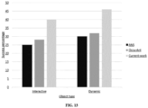
- An experiment has been conducted for a doctor-patient interaction.
- the experiment has been conducted based on state of art techniques (active neural SLAM and occupancy anticipation techniques) and the present disclosure of navigation of a tele-robot in dynamic environment using in-situ intelligence.
- the patient is in isolation and the tele-robot is in communication (based on disclosed application layer communication semantic) with a master that is located in a different location as shown in FIG.12 .
- the master shares an autonomous mode based on the application layer communication semantic to the tele-robot.
- the experimental results have been illustrated as a graph in FIG.13 , wherein the y-axis represents a success percentage that is indicative of (a) no collision (b) navigation till goal point. Further the x-axis represents the types of objects, specially the interactive object and the dynamic object identification and non- collision as experimented based on 3 types of techniques - active neural SLAM, occupancy anticipation techniques and the present disclosure (represented as current work on the graph).
- the embodiment of present disclosure herein is a method and a system for navigation of a tele-robot in dynamic environment using in-situ intelligence.
- Tele-robotics is the area of robotics concerned with the control of robots (tele-robots) in a remote environment from a distance.
- the remote environment where the tele robot navigates may be dynamic in nature with unpredictable movements, making the navigation extremely challenging.
- the disclosure proposes an in-situ intelligent navigation of a tele-robot in a dynamic environment.
- the disclosed in-situ intelligence enables the tele-robot to understand the dynamic environment by identification and estimation of future location of objects based on a generating/training a motion model. Further the disclosed techniques also enable communication between a master 102 and the tele-robot (whenever necessary) based on an application layer communication semantic.
- the hardware device can be any kind of device which can be programmed including e.g. any kind of computer like a server or a personal computer, or the like, or any combination thereof.
- the device may also include means which could be e.g. hardware means like e.g. an application-specific integrated circuit (ASIC), a field-programmable gate array (FPGA), or a combination of hardware and software means, e.g.
- ASIC application-specific integrated circuit
- FPGA field-programmable gate array
- the means can include both hardware means and software means.
- the method embodiments described herein could be implemented in hardware and software.
- the device may also include software means.
- the embodiments may be implemented on different hardware devices, e.g. using a plurality of CPUs.
- the embodiments herein can comprise hardware and software elements.
- the embodiments that are implemented in software include but are not limited to, firmware, resident software, microcode, etc.
- the functions performed by various components described herein may be implemented in other components or combinations of other components.
- a computer-usable or computer readable medium can be any apparatus that can comprise, store, communicate, propagate, or transport the program for use by or in connection with the instruction execution system, apparatus, or device.
- a computer-readable storage medium refers to any type of physical memory on which information or data readable by a processor may be stored.
- a computer-readable storage medium may store instructions for execution by one or more processors, including instructions for causing the processor(s) to perform steps or stages consistent with the embodiments described herein.
- the term "computer-readable medium” should be understood to include tangible items and exclude carrier waves and transient signals, i.e., be non-transitory. Examples include random access memory (RAM), read-only memory (ROM), volatile memory, nonvolatile memory, hard drives, CD ROMs, DVDs, flash drives, disks, and any other known physical storage media.
Landscapes
- Engineering & Computer Science (AREA)
- Robotics (AREA)
- Mechanical Engineering (AREA)
- Automation & Control Theory (AREA)
- Radar, Positioning & Navigation (AREA)
- Physics & Mathematics (AREA)
- Remote Sensing (AREA)
- Aviation & Aerospace Engineering (AREA)
- General Physics & Mathematics (AREA)
- Fuzzy Systems (AREA)
- Mathematical Physics (AREA)
- Software Systems (AREA)
- Evolutionary Computation (AREA)
- Artificial Intelligence (AREA)
- Human Computer Interaction (AREA)
- Control Of Position, Course, Altitude, Or Attitude Of Moving Bodies (AREA)
Claims (10)
- Prozessorimplementiertes Verfahren (300) zur intelligenten Vor-Ort-Navigation eines Teleroboters in einer dynamischen Umgebung, die durch einen Teleroboter und einen Master gekennzeichnet ist, wobei das Verfahren die folgenden Schritte umfasst:Initiieren, über einen oder mehrere Hardwareprozessoren, einer Kommunikation zwischen dem Teleroboter und dem Master, wobei die Kommunikation auf einer Anwendungsschicht-Kommunikationssemantik basiert, wobei die Kommunikation einer Mehrzahl von Betriebsmodi zugeordnet ist, die einen manuellen Modus und einen autonomen Modus beinhalten, und wobei sich der Teleroboter an einem entfernten Ort in der dynamischen Umgebung befindet (302);Empfangen, über einen oder mehrere Hardwareprozessoren, der Kommunikation bezüglich des Betriebsmodus an dem Teleroboter von dem Master und Bestimmen, ob der empfangene Betriebsmodus der manuelle Modus oder der autonome Modus ist, basierend auf der Anwendungsschicht-Kommunikationssemantik (304); undDurchführen (306), über einen oder mehrere Hardwareprozessoren, beim Bestimmen der Mehrzahl von Betriebsmodi, eines von:beim Bestimmen des manuellen Modus, Durchführen einer manuellen Navigation des Teleroboters, wie durch den Master angewiesen, basierend auf einer manuellen Kommunikationssemantik (308);beim Bestimmen des autonomen Modus (310), Durchführen der intelligenten Vor-Ort-Navigation des Teleroboters, umfassend die folgenden Schritte:Empfangen einer Tiefenkarte der dynamischen Umgebung von einer Mehrzahl von Sensoren und eines Zielpunkts von dem Master, wobei die Mehrzahl von Objekten eine Mehrzahl von statischen Objekten, eine Mehrzahl von interaktiven Objekten und eine Mehrzahl von dynamischen Objekten umfasst, wobei das interaktive Objekt ein Objekt ist, das durch Anwendung einer externen Kraft navigiert/sich bewegt, und das dynamische Objekt ohne die externe Kraft mit einer linearen Geschwindigkeit und einer Winkelgeschwindigkeit navigiert/sich bewegt (312);Schätzen einer aktuellen Position des Teleroboters basierend auf einer Simultaneous Localization and Mapping-SLAM-Technik unter Verwendung einer Geschwindigkeit, die dem Teleroboter zugeordnet ist, wobei die Geschwindigkeit des Teleroboters unter Verwendung einer Mehrzahl von Sensoren erhalten wird und die Geschwindigkeit eine Winkelgeschwindigkeit und eine lineare Geschwindigkeit beinhaltet (314);Erzeugen einer geozentrischen Draufsichtkarte aus der Tiefenkarte unter Verwendung der aktuellen Position des Teleroboters basierend auf einer räumlichen Transformations-ST-Technik, wobei die Tiefenkarte in eine egozentrische Karte umgewandelt wird, die eine Draufsicht der Tiefenkarte ist, und die egozentrische Karte an dem aktuellen Ort des Teleroboters unter Verwendung der ST-Technik projiziert wird, um die geozentrische Draufsichtkarte zu erzeugen, wobei die geozentrische Draufsichtkarte die aktuelle Position des Teleroboters und die Ortsdetails der Mehrzahl von Objekten umfasst (316);Empfangen eines Videofeeds der dynamischen Umgebung an dem Teleroboter unter Verwendung der Mehrzahl von Sensoren, wobei der Videofeed im RGB-Format ist (318);Identifizieren der Mehrzahl von interaktiven Objekten und der Mehrzahl von dynamischen Objekten in dem Videofeed basierend auf einer Objektdetektionstechnik (320);Schätzen (322), beim Identifizieren des Objekts, eines von:beim Bestimmen des interaktiven Objekts, Schätzen einer interaktiven Objektposition des interaktiven Objekts in der geozentrischen Draufsichtkarte basierend auf einer Positionsschätztechnik (324); undbeim Bestimmen des dynamischen Objekts, Schätzen einer zukünftigen Position des dynamischen Objekts in der geozentrischen Draufsichtkarte basierend auf einer zukünftigen Positionsschätztechnik unter Verwendung eines Bewegungsmodells (326), wobei die zukünftige Positionsschätztechnik (1000) die folgenden Schritte beinhaltet:Erzeugen einer egozentrischen Projektion des dynamischen Objekts in der geozentrischen Karte basierend auf einer Tiefensegmentierungstechnik (1002), wobei das Erzeugen der egozentrischen Projektion des dynamischen Objekts in der geozentrischen Draufsichtkarte basierend auf der Tiefensegmentierungstechnik ein Trennen der Tiefenkarte des dynamischen Objekts von dem Rest der Tiefenkarte durch Überlagern derselben auf einem dynamischen Objektdetektionsbegrenzungsrahmen, Aufnehmen der Pixel innerhalb des dynamischen Objektdetektionsbegrenzungsrahmens und von Tiefenwerten innerhalb eines Umrisses des dynamischen Objekts in der Tiefenkarte und Projizieren in die geozentrische Draufsichtkarte unter Verwendung der ST-Technik beinhaltet;Erhalten einer geozentrischen Darstellung des dynamischen Objekts durch das Passieren der egozentrischen Karte in der räumlichen Transformation ST unter Verwendung der Geschwindigkeit (1004); undSchätzen der zukünftigen Position des dynamischen Objekts basierend auf der geozentrischen Darstellung des dynamischen Objekts unter Verwendung des Bewegungsmodells (1006); undBestimmen einer lokalen Navigationsrichtlinie für den Teleroboter durch Passieren der geozentrischen Draufsichtkarte durch einen Fast Marching Motion Planner FMMP unter Verwendung der Zielpunkte, der aktuellen Position des Teleroboters und der interaktiven Objektposition/der zukünftigen dynamischen Objektposition (328).
- Verfahren nach Anspruch 1, wobei die Kommunikation eine semipersistente Echtzeitkommunikation ist, die eine vermittlerlose, eine Peer-to-Peer-, eine Beobachter-Produzent-Beziehung zwischen dem Master und dem Teleroboter beinhaltet.
- Verfahren nach Anspruch 1, wobei die Anwendungsschicht-Kommunikationssemantik ein Anwendungsschicht-Nachrichtenaustauschprotokoll zwischen dem Teleroboter und dem Master umfasst, das eine Anforderungsnachricht von dem Master an den Teleroboter und eine Mehrzahl von Antwortnachrichten von dem Teleroboter an den Master beinhaltet, wobei eine Anwendungsschichtnachricht binäre Darstellungen eines Typs und einen entsprechenden Wert für jeden Typ beinhaltet.
- Verfahren nach Anspruch 1, wobei die manuelle Kommunikationssemantiktechnik eine granulare Schritt-für-Schritt-Navigationsanforderung umfasst, die durch den Master basierend auf einer Videofeedantwort, die durch den Teleroboter mit dem Master geteilt wird, an den Teleroboter gesendet wird.
- Verfahren nach Anspruch 1, wobei die Simultaneous Localization and Mapping-SLAM-Technik eine aktive neuronale SLAM-Technik beinhaltet und die Mehrzahl von Sensoren eine Rot-Grün- und Blau-RGB-Kamera, ein Odometer und einen Tiefensensor beinhaltet.
- Verfahren nach Anspruch 1, wobei die Positionsschätztechnik (900) Folgendes umfasst:Erzeugen einer egozentrischen Projektion des interaktiven Objekts in der geozentrischen Draufsichtkarte basierend auf einer Tiefensegmentierungstechnik (902), wobei das Erzeugen der egozentrischen Projektion des interaktiven Objekts in der geozentrischen Draufsichtkarte basierend auf der Tiefensegmentierungstechnik ein Trennen der Tiefenkarte des interaktiven Objekts von dem Rest der Tiefenkarte durch Überlagern derselben auf einem interaktiven Objektdetektionsbegrenzungsrahmen, Aufnehmen der Pixel innerhalb des interaktiven Objektdetektionsbegrenzungsrahmens und von Tiefenwerten innerhalb eines Umrisses des interaktiven Objekts in der Tiefenkarte und Projizieren in die geozentrische Draufsichtkarte unter Verwendung der ST-Technik beinhaltet; undPassieren der egozentrischen Projektion des interaktiven Objekts von der egozentrischen Karte in der ST, um eine geozentrische Darstellung des interaktiven Objekts unter Verwendung der Geschwindigkeit zu erhalten, wobei die geozentrische Darstellung die Position des interaktiven Objekts (904) ist.
- Verfahren nach Anspruch 1, wobei das Bewegungsmodell eine zukünftige Trajektorie für das dynamische Objekt mit einer abnehmenden Hindernisgrenze für einen vordefinierten Zeitschritt basierend auf der linearen Geschwindigkeit des dynamischen Objekts und einer Winkelgeschwindigkeit des dynamischen Objekts schätzt.
- System (200), umfassend:eine Eingabe-/Ausgabeschnittstelle (206);einen oder mehrere Speicher (202); undeinen oder mehrere Hardwareprozessoren (204), wobei der eine oder die mehreren Speicher (202) mit dem einen oder den mehreren Hardwareprozessoren (204) gekoppelt sind, wobei der eine oder die mehreren Hardwareprozessoren (204) konfiguriert sind, um programmierte Anweisungen auszuführen, die in dem einen oder den mehreren Speichern (202) gespeichert sind, um:über einen oder mehrere Hardwareprozessoren eine Kommunikation zwischen dem Teleroboter und dem Master zu initiieren, wobei die Kommunikation auf einer Anwendungsschicht-Kommunikationssemantik basiert, wobei die Kommunikation einer Mehrzahl von Betriebsmodi zugeordnet ist, die einen manuellen Modus und einen autonomen Modus beinhalten, und wobei sich der Teleroboter an einem entfernten Ort in der dynamischen Umgebung befindet;über einen oder mehrere Hardwareprozessoren die Kommunikation bezüglich des Betriebsmodus an dem Teleroboter von dem Master zu empfangen und basierend auf der Anwendungsschicht-Kommunikationssemantik zu bestimmen, ob der empfangene Betriebsmodus der manuelle Modus oder der autonome Modus ist; undüber einen oder mehrere Hardwareprozessoren beim Bestimmen der Mehrzahl von Betriebsmodi eines von Folgendem durchzuführen:beim Bestimmen des manuellen Modus, Durchführen einer manuellen Navigation des Teleroboters, wie durch den Master angewiesen, basierend auf einer manuellen Kommunikationssemantik;beim Bestimmen des autonomen Modus, Durchführen der intelligenten Vor-Ort-Navigation des Teleroboters, umfassend die folgenden Schritte:Empfangen einer Tiefenkarte der dynamischen Umgebung von einer Mehrzahl von Sensoren und eines Zielpunkts von dem Master, wobei die Mehrzahl von Objekten eine Mehrzahl von statischen Objekten, eine Mehrzahl von interaktiven Objekten und eine Mehrzahl von dynamischen Objekten umfasst, wobei das interaktive Objekt ein Objekt ist, das durch Anwendung einer externen Kraft navigiert/sich bewegt, und das dynamische Objekt ohne die externe Kraft mit einer linearen Geschwindigkeit und einer Winkelgeschwindigkeit navigiert/sich bewegt;Schätzen einer aktuellen Position des Teleroboters basierend auf einer Simultaneous Localization and Mapping-SLAM-Technik unter Verwendung einer Geschwindigkeit, die dem Teleroboter zugeordnet ist, wobei die Geschwindigkeit des Teleroboters unter Verwendung einer Mehrzahl von Sensoren erhalten wird und die Geschwindigkeit eine Winkelgeschwindigkeit und eine lineare Geschwindigkeit beinhaltet;Erzeugen einer geozentrischen Draufsichtkarte aus der Tiefenkarte unter Verwendung der aktuellen Position des Teleroboters basierend auf einer räumlichen Transformations-ST-Technik, wobei die Tiefenkarte in eine egozentrische Karte umgewandelt wird, die eine Draufsicht der Tiefenkarte ist, und die egozentrische Karte an dem aktuellen Ort des Teleroboters unter Verwendung der ST-Technik projiziert wird, um die geozentrische Draufsichtkarte zu erzeugen, wobei die geozentrische Draufsichtkarte die aktuelle Position des Teleroboters und die Ortsdetails der Mehrzahl von Objekten umfasst;Empfangen eines Videofeeds der dynamischen Umgebung an dem Teleroboter unter Verwendung der Mehrzahl von Sensoren, wobei der Videofeed im RGB-Format ist;Identifizieren der Mehrzahl von interaktiven Objekten und der Mehrzahl von dynamischen Objekten in dem Videofeed basierend auf einer Objektdetektionstechnik;Schätzen, beim Identifizieren des Objekts, eines von:beim Bestimmen des interaktiven Objekts, Schätzen einer interaktiven Objektposition des interaktiven Objekts in der geozentrischen Draufsichtkarte basierend auf einer Positionsschätztechnik; undbeim Bestimmen des dynamischen Objekts, Schätzen einer zukünftigen Position des dynamischen Objekts in der geozentrischen Draufsichtkarte basierend auf einer zukünftigen Positionsschätztechnik unter Verwendung eines Bewegungsmodells, wobei die zukünftige Positionsschätztechnik die folgenden Schritte beinhaltet:Erzeugen einer egozentrischen Projektion des dynamischen Objekts in der geozentrischen Karte basierend auf einer Tiefensegmentierungstechnik, wobei das Erzeugen der egozentrischen Projektion des dynamischen Objekts in der geozentrischen Draufsichtkarte basierend auf der Tiefensegmentierungstechnik ein Trennen der Tiefenkarte des dynamischen Objekts von dem Rest der Tiefenkarte durch Überlagern derselben auf einem dynamischen Objektdetektionsbegrenzungsrahmen, Aufnehmen der Pixel innerhalb des dynamischen Objektdetektionsbegrenzungsrahmens und von Tiefenwerten innerhalb eines Umrisses des dynamischen Objekts in der Tiefenkarte und Projizieren in die geozentrische Draufsichtkarte unter Verwendung der ST-Technik beinhaltet;Erhalten einer geozentrischen Darstellung des dynamischen Objekts durch Passieren der egozentrischen Karte in der räumlichen Transformation ST unter Verwendung der Geschwindigkeit; undSchätzen der zukünftigen Position des dynamischen Objekts basierend auf der geozentrischen Darstellung des dynamischen Objekts unter Verwendung des Bewegungsmodells; undBestimmen einer lokalen Navigationsrichtlinie für den Teleroboter durch Passieren der geozentrischen Draufsichtkarte durch einen Fast Marching Motion Planner FMMP unter Verwendung der Zielpunkte, der aktuellen Position des Teleroboters und der interaktiven Objektposition/der zukünftigen dynamischen Objektposition.
- System nach Anspruch 8, wobei der eine oder die mehreren Hardwareprozessoren durch die Anweisungen konfiguriert sind, um die Positionsschätztechnik zu implementieren, umfassend:Erzeugen einer egozentrischen Projektion des interaktiven Objekts in der geozentrischen Draufsichtkarte basierend auf einer Tiefensegmentierungstechnik, wobei das Erzeugen der egozentrischen Projektion des interaktiven Objekts in der geozentrischen Draufsichtkarte basierend auf der Tiefensegmentierungstechnik ein Trennen der Tiefenkarte des interaktiven Objekts von dem Rest der Tiefenkarte durch Überlagern derselben auf einem interaktiven Objektdetektionsbegrenzungsrahmen, Aufnehmen der Pixel innerhalb des interaktiven Objektdetektionsbegrenzungsrahmens und von Tiefenwerten innerhalb eines Umrisses des interaktiven Objekts in der Tiefenkarte und Projizieren in die geozentrische Karte unter Verwendung der ST-Technik beinhaltet; undPassieren der egozentrischen Projektion des interaktiven Objekts von der egozentrischen Karte in der ST, um eine geozentrische Darstellung des interaktiven Objekts unter Verwendung der Geschwindigkeit zu erhalten, wobei die geozentrische Darstellung die Position des interaktiven Objekts ist.
- Nichtflüchtiges computerlesbares Medium, auf dem ein computerlesbares Programm verkörpert ist, wobei das computerlesbare Programm, wenn es von einem oder mehreren Hardwareprozessoren ausgeführt wird, Folgendes bewirkt:Initiieren, über einen oder mehrere Hardwareprozessoren, einer Kommunikation zwischen dem Teleroboter und dem Master, wobei die Kommunikation auf einer Anwendungsschicht-Kommunikationssemantik basiert, wobei die Kommunikation einer Mehrzahl von Betriebsmodi zugeordnet ist, die einen manuellen Modus und einen autonomen Modus beinhalten, und wobei sich der Teleroboter an einem entfernten Ort in der dynamischen Umgebung befindet;Empfangen, über einen oder mehrere Hardwareprozessoren, der Kommunikation bezüglich des Betriebsmodus an dem Teleroboter von dem Master und Bestimmen, ob der empfangene Betriebsmodus der manuelle Modus oder der autonome Modus ist, basierend auf der Anwendungsschicht-Kommunikationssemantik; undDurchführen, über einen oder mehrere Hardwareprozessoren beim Bestimmen der Mehrzahl von Betriebsmodi, eines von:beim Bestimmen des manuellen Modus, Durchführen einer manuellen Navigation des Teleroboters, wie durch den Master angewiesen, basierend auf einer manuellen Kommunikationssemantik;beim Bestimmen des autonomen Modus, Durchführen der intelligenten Vor-Ort-Navigation des Teleroboters, umfassend die folgenden Schritte:Empfangen einer Tiefenkarte der dynamischen Umgebung von einer Mehrzahl von Sensoren und eines Zielpunkts von dem Master, wobei die Mehrzahl von Objekten eine Mehrzahl von statischen Objekten, eine Mehrzahl von interaktiven Objekten und eine Mehrzahl von dynamischen Objekten umfasst, wobei das interaktive Objekt ein Objekt ist, das durch Anwendung einer externen Kraft navigiert/sich bewegt, und das dynamische Objekt ohne die externe Kraft mit einer linearen Geschwindigkeit und einer Winkelgeschwindigkeit navigiert/sich bewegt;Schätzen einer aktuellen Position des Teleroboters basierend auf einer Simultaneous Localization and Mapping-SLAM-Technik unter Verwendung einer Geschwindigkeit, die dem Teleroboter zugeordnet ist, wobei die Geschwindigkeit des Teleroboters unter Verwendung einer Mehrzahl von Sensoren erhalten wird und die Geschwindigkeit eine Winkelgeschwindigkeit und eine lineare Geschwindigkeit beinhaltet;Erzeugen einer geozentrischen Draufsichtkarte aus der Tiefenkarte unter Verwendung der aktuellen Position des Teleroboters basierend auf einer räumlichen Transformations-ST-Technik, wobei die Tiefenkarte in eine egozentrische Karte umgewandelt wird, die eine Draufsicht der Tiefenkarte ist, und die egozentrische Karte an dem aktuellen Ort des Teleroboters unter Verwendung der ST-Technik projiziert wird, um die geozentrische Draufsichtkarte zu erzeugen, wobei die geozentrische Draufsichtkarte die aktuelle Position des Teleroboters und die Ortsdetails der Mehrzahl von Objekten umfasst;Empfangen eines Videofeeds der dynamischen Umgebung an dem Teleroboter unter Verwendung der Mehrzahl von Sensoren, wobei der Videofeed im RGB-Format ist;Identifizieren der Mehrzahl von interaktiven Objekten und der Mehrzahl von dynamischen Objekten in dem Videofeed basierend auf einer Objektdetektionstechnik;Schätzen, beim Identifizieren des Objekts, eines von:beim Bestimmen des interaktiven Objekts, Schätzen einer interaktiven Objektposition des interaktiven Objekts in der geozentrischen Draufsichtkarte basierend auf einer Positionsschätztechnik; undbeim Bestimmen des dynamischen Objekts, Schätzen einer zukünftigen Position des dynamischen Objekts in der geozentrischen Draufsichtkarte basierend auf einer zukünftigen Positionsschätztechnik unter Verwendung eines Bewegungsmodells, wobei die zukünftige Positionsschätztechnik (1000) die folgenden Schritte beinhaltet:Erzeugen einer egozentrischen Projektion des dynamischen Objekts in der geozentrischen Karte basierend auf einer Tiefensegmentierungstechnik (1002), wobei das Erzeugen der egozentrischen Projektion des dynamischen Objekts in der geozentrischen Draufsichtkarte basierend auf der Tiefensegmentierungstechnik ein Trennen der Tiefenkarte des dynamischen Objekts von dem Rest der Tiefenkarte durch Überlagern derselben auf einem dynamischen Objektdetektionsbegrenzungsrahmen, Aufnehmen der Pixel innerhalb des dynamischen Objektdetektionsbegrenzungsrahmens und von Tiefenwerten innerhalb eines Umrisses des dynamischen Objekts in der Tiefenkarte und Projizieren in die geozentrische Draufsichtkarte unter Verwendung der ST-Technik beinhaltet;Erhalten einer geozentrischen Darstellung des dynamischen Objekts durch Passieren der egozentrischen Karte in der räumlichen Transformation ST unter Verwendung der Geschwindigkeit (1004); undSchätzen der zukünftigen Position des dynamischen Objekts basierend auf der geozentrischen Darstellung des dynamischen Objekts unter Verwendung des Bewegungsmodells (1006); undBestimmen einer lokalen Navigationsrichtlinie für den Teleroboter durch Passieren der geozentrischen Draufsichtkarte durch einen Fast Marching Motion Planner FMMP unter Verwendung der Zielpunkte, der aktuellen Position des Teleroboters und der interaktiven Objektposition/der zukünftigen dynamischen Objektposition.
Applications Claiming Priority (1)
| Application Number | Priority Date | Filing Date | Title |
|---|---|---|---|
| IN202121000976 | 2021-01-08 |
Publications (3)
| Publication Number | Publication Date |
|---|---|
| EP4026663A1 EP4026663A1 (de) | 2022-07-13 |
| EP4026663B1 true EP4026663B1 (de) | 2024-08-28 |
| EP4026663C0 EP4026663C0 (de) | 2024-08-28 |
Family
ID=74867416
Family Applications (1)
| Application Number | Title | Priority Date | Filing Date |
|---|---|---|---|
| EP21161405.2A Active EP4026663B1 (de) | 2021-01-08 | 2021-03-09 | Navigation eines tele-roboters in einer dynamischen umgebung mittels in-situ-intelligenz |
Country Status (2)
| Country | Link |
|---|---|
| US (1) | US11794347B2 (de) |
| EP (1) | EP4026663B1 (de) |
Family Cites Families (8)
| Publication number | Priority date | Publication date | Assignee | Title |
|---|---|---|---|---|
| US7539557B2 (en) * | 2005-12-30 | 2009-05-26 | Irobot Corporation | Autonomous mobile robot |
| US8271132B2 (en) * | 2008-03-13 | 2012-09-18 | Battelle Energy Alliance, Llc | System and method for seamless task-directed autonomy for robots |
| CN103459099B (zh) * | 2011-01-28 | 2015-08-26 | 英塔茨科技公司 | 与一个可移动的远程机器人相互交流 |
| CN106060058A (zh) | 2016-06-16 | 2016-10-26 | 华南理工大学 | 基于互联网的工业机器人远程控制方法 |
| US11016491B1 (en) * | 2018-01-26 | 2021-05-25 | X Development Llc | Trajectory planning for mobile robots |
| WO2019178144A1 (en) * | 2018-03-12 | 2019-09-19 | Creator, Inc. | Control system architecture and distributed human-machine interface for robot control |
| US11307584B2 (en) * | 2018-09-04 | 2022-04-19 | Skydio, Inc. | Applications and skills for an autonomous unmanned aerial vehicle |
| US11455813B2 (en) * | 2019-11-14 | 2022-09-27 | Nec Corporation | Parametric top-view representation of complex road scenes |
-
2021
- 2021-03-09 EP EP21161405.2A patent/EP4026663B1/de active Active
- 2021-03-11 US US17/199,182 patent/US11794347B2/en active Active
Also Published As
| Publication number | Publication date |
|---|---|
| US20220219325A1 (en) | 2022-07-14 |
| EP4026663C0 (de) | 2024-08-28 |
| US11794347B2 (en) | 2023-10-24 |
| EP4026663A1 (de) | 2022-07-13 |
Similar Documents
| Publication | Publication Date | Title |
|---|---|---|
| US12505925B2 (en) | Interfacing with a mobile telepresence robot | |
| US20240353838A1 (en) | Autonomous platform guidance systems with task planning and obstacle avoidance | |
| US12105518B1 (en) | Autonomous platform guidance systems with unknown environment mapping | |
| US10571925B1 (en) | Autonomous platform guidance systems with auxiliary sensors and task planning | |
| US10571926B1 (en) | Autonomous platform guidance systems with auxiliary sensors and obstacle avoidance | |
| EP4209849A1 (de) | Teleanwesenheitsroboter mit kognitiver navigationsfähigkeit | |
| US20220066465A1 (en) | Monocular Modes for Autonomous Platform Guidance Systems with Auxiliary Sensors | |
| KR102724007B1 (ko) | 상황 인식 모니터링 | |
| Tardioli et al. | Robot teams for intervention in confined and structured environments | |
| DE112011104644T5 (de) | Mobiles Roboter-System | |
| US20220184808A1 (en) | Motion trajectory planning method for robotic manipulator, robotic manipulator and computer-readable storage medium | |
| EP4026663B1 (de) | Navigation eines tele-roboters in einer dynamischen umgebung mittels in-situ-intelligenz | |
| CN116206190A (zh) | 基于Web应用及语义信息的室内导航系统及其控制方法 | |
| Herrera-Medina et al. | Optimizing Path Planning and Human Detection Using YOLO and an RRT Algorithm in Autonomous Robots | |
| Rodriguez-Tirado et al. | A pipeline framework for robot maze navigation using computer vision, path planning and communication protocols | |
| CN118037772B (zh) | 基于移动机器人的姿态估计方法、装置和计算机设备 | |
| Baroudi et al. | Cloud-based autonomous indoor navigation: a case study | |
| Giannetto | Increasing the abilities of mobile robots with Computer Vision algorithms | |
| Boroujeni | Visual Data Analytic and Robotics for Automated Construction Performance Monitoring | |
| KR20260053732A (ko) | 로봇팔 좌표 추정 장치, 로봇팔 좌표 추정 시스템 및 방법 | |
| Cheng et al. | A biologically inspired intelligent environment architecture for mobile robot navigation |
Legal Events
| Date | Code | Title | Description |
|---|---|---|---|
| PUAI | Public reference made under article 153(3) epc to a published international application that has entered the european phase |
Free format text: ORIGINAL CODE: 0009012 |
|
| STAA | Information on the status of an ep patent application or granted ep patent |
Free format text: STATUS: THE APPLICATION HAS BEEN PUBLISHED |
|
| AK | Designated contracting states |
Kind code of ref document: A1 Designated state(s): AL AT BE BG CH CY CZ DE DK EE ES FI FR GB GR HR HU IE IS IT LI LT LU LV MC MK MT NL NO PL PT RO RS SE SI SK SM TR |
|
| STAA | Information on the status of an ep patent application or granted ep patent |
Free format text: STATUS: REQUEST FOR EXAMINATION WAS MADE |
|
| 17P | Request for examination filed |
Effective date: 20220719 |
|
| RBV | Designated contracting states (corrected) |
Designated state(s): AL AT BE BG CH CY CZ DE DK EE ES FI FR GB GR HR HU IE IS IT LI LT LU LV MC MK MT NL NO PL PT RO RS SE SI SK SM TR |
|
| GRAP | Despatch of communication of intention to grant a patent |
Free format text: ORIGINAL CODE: EPIDOSNIGR1 |
|
| STAA | Information on the status of an ep patent application or granted ep patent |
Free format text: STATUS: GRANT OF PATENT IS INTENDED |
|
| INTG | Intention to grant announced |
Effective date: 20240527 |
|
| RIN1 | Information on inventor provided before grant (corrected) |
Inventor name: BHOWMICK, BROJESHWAR Inventor name: PAUL, SAYAN Inventor name: GANGULY, MADHURIMA Inventor name: SAU, ASHIS Inventor name: BISWAS, SANDIKA Inventor name: SINHA, SANJANA Inventor name: ROYCHOUDHURY, RUDDRA Inventor name: BHATTACHARYYA, ABHIJAN |
|
| GRAS | Grant fee paid |
Free format text: ORIGINAL CODE: EPIDOSNIGR3 |
|
| GRAA | (expected) grant |
Free format text: ORIGINAL CODE: 0009210 |
|
| STAA | Information on the status of an ep patent application or granted ep patent |
Free format text: STATUS: THE PATENT HAS BEEN GRANTED |
|
| AK | Designated contracting states |
Kind code of ref document: B1 Designated state(s): AL AT BE BG CH CY CZ DE DK EE ES FI FR GB GR HR HU IE IS IT LI LT LU LV MC MK MT NL NO PL PT RO RS SE SI SK SM TR |
|
| REG | Reference to a national code |
Ref country code: CH Ref legal event code: EP |
|
| REG | Reference to a national code |
Ref country code: DE Ref legal event code: R096 Ref document number: 602021017738 Country of ref document: DE |
|
| REG | Reference to a national code |
Ref country code: IE Ref legal event code: FG4D |
|
| U01 | Request for unitary effect filed |
Effective date: 20240828 |
|
| U07 | Unitary effect registered |
Designated state(s): AT BE BG DE DK EE FI FR IT LT LU LV MT NL PT RO SE SI Effective date: 20240906 |
|
| PG25 | Lapsed in a contracting state [announced via postgrant information from national office to epo] |
Ref country code: NO Free format text: LAPSE BECAUSE OF FAILURE TO SUBMIT A TRANSLATION OF THE DESCRIPTION OR TO PAY THE FEE WITHIN THE PRESCRIBED TIME-LIMIT Effective date: 20241128 |
|
| PG25 | Lapsed in a contracting state [announced via postgrant information from national office to epo] |
Ref country code: GR Free format text: LAPSE BECAUSE OF FAILURE TO SUBMIT A TRANSLATION OF THE DESCRIPTION OR TO PAY THE FEE WITHIN THE PRESCRIBED TIME-LIMIT Effective date: 20241129 Ref country code: PL Free format text: LAPSE BECAUSE OF FAILURE TO SUBMIT A TRANSLATION OF THE DESCRIPTION OR TO PAY THE FEE WITHIN THE PRESCRIBED TIME-LIMIT Effective date: 20240828 |
|
| PG25 | Lapsed in a contracting state [announced via postgrant information from national office to epo] |
Ref country code: IS Free format text: LAPSE BECAUSE OF FAILURE TO SUBMIT A TRANSLATION OF THE DESCRIPTION OR TO PAY THE FEE WITHIN THE PRESCRIBED TIME-LIMIT Effective date: 20241228 |
|
| PG25 | Lapsed in a contracting state [announced via postgrant information from national office to epo] |
Ref country code: HR Free format text: LAPSE BECAUSE OF FAILURE TO SUBMIT A TRANSLATION OF THE DESCRIPTION OR TO PAY THE FEE WITHIN THE PRESCRIBED TIME-LIMIT Effective date: 20240828 |
|
| PG25 | Lapsed in a contracting state [announced via postgrant information from national office to epo] |
Ref country code: RS Free format text: LAPSE BECAUSE OF FAILURE TO SUBMIT A TRANSLATION OF THE DESCRIPTION OR TO PAY THE FEE WITHIN THE PRESCRIBED TIME-LIMIT Effective date: 20241128 Ref country code: ES Free format text: LAPSE BECAUSE OF FAILURE TO SUBMIT A TRANSLATION OF THE DESCRIPTION OR TO PAY THE FEE WITHIN THE PRESCRIBED TIME-LIMIT Effective date: 20240828 |
|
| PG25 | Lapsed in a contracting state [announced via postgrant information from national office to epo] |
Ref country code: RS Free format text: LAPSE BECAUSE OF FAILURE TO SUBMIT A TRANSLATION OF THE DESCRIPTION OR TO PAY THE FEE WITHIN THE PRESCRIBED TIME-LIMIT Effective date: 20241128 Ref country code: PL Free format text: LAPSE BECAUSE OF FAILURE TO SUBMIT A TRANSLATION OF THE DESCRIPTION OR TO PAY THE FEE WITHIN THE PRESCRIBED TIME-LIMIT Effective date: 20240828 Ref country code: NO Free format text: LAPSE BECAUSE OF FAILURE TO SUBMIT A TRANSLATION OF THE DESCRIPTION OR TO PAY THE FEE WITHIN THE PRESCRIBED TIME-LIMIT Effective date: 20241128 Ref country code: IS Free format text: LAPSE BECAUSE OF FAILURE TO SUBMIT A TRANSLATION OF THE DESCRIPTION OR TO PAY THE FEE WITHIN THE PRESCRIBED TIME-LIMIT Effective date: 20241228 Ref country code: HR Free format text: LAPSE BECAUSE OF FAILURE TO SUBMIT A TRANSLATION OF THE DESCRIPTION OR TO PAY THE FEE WITHIN THE PRESCRIBED TIME-LIMIT Effective date: 20240828 Ref country code: GR Free format text: LAPSE BECAUSE OF FAILURE TO SUBMIT A TRANSLATION OF THE DESCRIPTION OR TO PAY THE FEE WITHIN THE PRESCRIBED TIME-LIMIT Effective date: 20241129 Ref country code: ES Free format text: LAPSE BECAUSE OF FAILURE TO SUBMIT A TRANSLATION OF THE DESCRIPTION OR TO PAY THE FEE WITHIN THE PRESCRIBED TIME-LIMIT Effective date: 20240828 |
|
| PG25 | Lapsed in a contracting state [announced via postgrant information from national office to epo] |
Ref country code: SM Free format text: LAPSE BECAUSE OF FAILURE TO SUBMIT A TRANSLATION OF THE DESCRIPTION OR TO PAY THE FEE WITHIN THE PRESCRIBED TIME-LIMIT Effective date: 20240828 |
|
| PG25 | Lapsed in a contracting state [announced via postgrant information from national office to epo] |
Ref country code: CZ Free format text: LAPSE BECAUSE OF FAILURE TO SUBMIT A TRANSLATION OF THE DESCRIPTION OR TO PAY THE FEE WITHIN THE PRESCRIBED TIME-LIMIT Effective date: 20240828 |
|
| PG25 | Lapsed in a contracting state [announced via postgrant information from national office to epo] |
Ref country code: SK Free format text: LAPSE BECAUSE OF FAILURE TO SUBMIT A TRANSLATION OF THE DESCRIPTION OR TO PAY THE FEE WITHIN THE PRESCRIBED TIME-LIMIT Effective date: 20240828 |
|
| U20 | Renewal fee for the european patent with unitary effect paid |
Year of fee payment: 5 Effective date: 20250325 |
|
| PLBE | No opposition filed within time limit |
Free format text: ORIGINAL CODE: 0009261 |
|
| STAA | Information on the status of an ep patent application or granted ep patent |
Free format text: STATUS: NO OPPOSITION FILED WITHIN TIME LIMIT |
|
| PGFP | Annual fee paid to national office [announced via postgrant information from national office to epo] |
Ref country code: CH Payment date: 20250401 Year of fee payment: 5 |
|
| 26N | No opposition filed |
Effective date: 20250530 |
|
| PG25 | Lapsed in a contracting state [announced via postgrant information from national office to epo] |
Ref country code: MC Free format text: LAPSE BECAUSE OF FAILURE TO SUBMIT A TRANSLATION OF THE DESCRIPTION OR TO PAY THE FEE WITHIN THE PRESCRIBED TIME-LIMIT Effective date: 20240828 |
|
| PG25 | Lapsed in a contracting state [announced via postgrant information from national office to epo] |
Ref country code: IE Free format text: LAPSE BECAUSE OF NON-PAYMENT OF DUE FEES Effective date: 20250309 |
|
| REG | Reference to a national code |
Ref country code: CH Ref legal event code: U11 Free format text: ST27 STATUS EVENT CODE: U-0-0-U10-U11 (AS PROVIDED BY THE NATIONAL OFFICE) Effective date: 20260401 |
|
| PGFP | Annual fee paid to national office [announced via postgrant information from national office to epo] |
Ref country code: GB Payment date: 20260304 Year of fee payment: 6 |