EP4024328B1 - Method and apparatus for map fusion, server and storage medium - Google Patents
Method and apparatus for map fusion, server and storage medium Download PDFInfo
- Publication number
- EP4024328B1 EP4024328B1 EP21791231.0A EP21791231A EP4024328B1 EP 4024328 B1 EP4024328 B1 EP 4024328B1 EP 21791231 A EP21791231 A EP 21791231A EP 4024328 B1 EP4024328 B1 EP 4024328B1
- Authority
- EP
- European Patent Office
- Prior art keywords
- information
- relative
- map data
- dimensional
- dimensional map
- Prior art date
- Legal status (The legal status is an assumption and is not a legal conclusion. Google has not performed a legal analysis and makes no representation as to the accuracy of the status listed.)
- Active
Links
Images




Classifications
-
- G—PHYSICS
- G06—COMPUTING OR CALCULATING; COUNTING
- G06T—IMAGE DATA PROCESSING OR GENERATION, IN GENERAL
- G06T3/00—Geometric image transformations in the plane of the image
- G06T3/40—Scaling of whole images or parts thereof, e.g. expanding or contracting
- G06T3/4038—Image mosaicing, e.g. composing plane images from plane sub-images
-
- G—PHYSICS
- G06—COMPUTING OR CALCULATING; COUNTING
- G06T—IMAGE DATA PROCESSING OR GENERATION, IN GENERAL
- G06T5/00—Image enhancement or restoration
- G06T5/50—Image enhancement or restoration using two or more images, e.g. averaging or subtraction
-
- G—PHYSICS
- G06—COMPUTING OR CALCULATING; COUNTING
- G06F—ELECTRIC DIGITAL DATA PROCESSING
- G06F18/00—Pattern recognition
- G06F18/20—Analysing
- G06F18/22—Matching criteria, e.g. proximity measures
-
- G—PHYSICS
- G06—COMPUTING OR CALCULATING; COUNTING
- G06T—IMAGE DATA PROCESSING OR GENERATION, IN GENERAL
- G06T7/00—Image analysis
- G06T7/10—Segmentation; Edge detection
- G06T7/11—Region-based segmentation
-
- G—PHYSICS
- G06—COMPUTING OR CALCULATING; COUNTING
- G06V—IMAGE OR VIDEO RECOGNITION OR UNDERSTANDING
- G06V10/00—Arrangements for image or video recognition or understanding
- G06V10/40—Extraction of image or video features
- G06V10/44—Local feature extraction by analysis of parts of the pattern, e.g. by detecting edges, contours, loops, corners, strokes or intersections; Connectivity analysis, e.g. of connected components
-
- G—PHYSICS
- G06—COMPUTING OR CALCULATING; COUNTING
- G06T—IMAGE DATA PROCESSING OR GENERATION, IN GENERAL
- G06T2207/00—Indexing scheme for image analysis or image enhancement
- G06T2207/20—Special algorithmic details
- G06T2207/20212—Image combination
- G06T2207/20221—Image fusion; Image merging
Definitions
- the present disclosure relates to the field of map technology, and more particularly, to a map fusion method, a map fusion apparatus, a server, and a storage medium.
- AVP-SLAM Semantic Visual Mapping and Localization for Autonomous Vehicles in the Parking Lot
- ARXIV.ORG 8 July 2020 (2020-07-08 ) proposes a semantic-feature-based mapping and localization system, which enables vehicles to automatically navigate in parking lots.
- a computer-implemented map fusion method for overcoming the above problems or at least partially solve the above problems.
- the -A- map fusion method includes: obtaining first three-dimensional map data and second three-dimensional map data; determining, for at least two first semantic elements in the first three-dimensional map data, at least two second semantic elements in the second three-dimensional map data that match the at least two first semantic elements; determining first relative information between the at least two first semantic elements, and determining second relative information between the at least two second semantic elements; optimizing the first three-dimensional map data and the second three-dimensional map data based on the first relative information and the second relative information; and performing a map fusion on the optimized first three-dimensional map data and the optimized second three-dimensional map data.
- Said optimizing the first three-dimensional map data and the second three-dimensional map data based on the first relative information and the second relative information includes: determining target information of the at least two first semantic elements and the at least two second semantic elements based on the first relative information and the second relative information; and optimizing the first three-dimensional map data and the second three-dimensional map data based on the target information of the at least two first semantic elements and the at least two second semantic elements, where wherein the first relative information includes first two-dimensional relative information and first three-dimensional relative information, the second relative information includes second two-dimensional relative information and second three-dimensional relative information, and the target information includes target two-dimensional information and target three-dimensional information.
- the first two-dimensional relative information includes first relative pose information
- the second two-dimensional relative information includes second relative pose information
- the target two-dimensional information is target pose information
- said determining the target information of the at least two first semantic elements and the at least two second semantic elements based on the first relative information and the second relative information includes: determining a pose error value based on the first relative pose information and the second relative pose information; determining, based on the pose error value, an association between pose information of the at least two first semantic elements and the at least two second semantic elements and a relative pose error; and determining the target pose information of the at least two first semantic elements and the at least two second semantic elements under a premise of a minimum relative pose error.
- the first three-dimensional relative information includes first relative height information
- the second three-dimensional relative information includes second relative height information
- the target three-dimensional information is target height information
- said determining the target information of the at least two first semantic elements and the at least two second semantic elements based on the first relative information and the second relative information includes: determining a height error value based on the first relative height information and the second relative height information; determining, based on the height error value, an association between height information of the at least two first semantic elements and the at least two second semantic elements and a relative height error; and determining target height information of the at least two first semantic elements and the at least two second semantic elements under a premise of a minimum relative height error.
- the method further includes: determining a first conversion matrix for the first three-dimensional map data and a second conversion matrix for the second three-dimensional map data based on the at least two first semantic elements and the at least two second semantic elements; and adjusting the first three-dimensional map data by using the first conversion matrix, and adjusting the second three-dimensional map data by using the second conversion matrix.
- the method further includes: determining a third semantic element in the first three-dimensional map data, where no matching semantic element in the second three-dimensional map data matches the third semantic element; and adding the third semantic element to the map-fused second three-dimensional map data.
- the first three-dimensional map data and the second three-dimensional map data are map data for a parking lot.
- a map fusion apparatus includes a three-dimensional map data obtaining module configured to obtain first three-dimensional map data and second three-dimensional map data; a semantic element determining module configured to determine, for at least two first semantic elements in the first three-dimensional map data, at least two second semantic elements in the second three-dimensional map data that match the at least two first semantic elements; a relative information determining module configured to determine first relative information between the at least two first semantic elements, and determine second relative information between the at least two second semantic elements; an optimization module configured to optimize the first three-dimensional map data and the second three-dimensional map data based on the first relative information and the second relative information; and a fusion module configured to perform a map fusion on the optimized first three-dimensional map data and the optimized second three-dimensional map data.
- the optimization module includes: a target information determining sub-module configured to determine target information of the at least two first semantic elements and the at least two second semantic elements based on the first relative information and the second relative information; and a three-dimensional map data optimization sub-module configured to optimize the first three-dimensional map data and the second three-dimensional map data based on the target information of the at least two first semantic elements and the at least two second semantic elements, where the first relative information includes first two-dimensional relative information and first three-dimensional relative information, the second relative information includes second two-dimensional relative information and second three-dimensional relative information, and the target information includes target two-dimensional information and target three-dimensional information.
- the first two-dimensional relative information includes first relative pose information
- the second two-dimensional relative information includes second relative pose information
- the target two-dimensional information is target pose information
- the target information determining sub-module includes: a pose error determining unit configured to determine a pose error value based on the first relative pose information and the second relative pose information; a relative pose error association determining unit configured to determine, based on the pose error value, an association between pose information of the at least two first semantic elements and the at least two second semantic elements and a relative pose error; and a target pose information determining unit configured to determine the target pose information of the at least two first semantic elements and the at least two second semantic elements under a premise of a minimum relative pose error.
- a server includes a processor, a memory, and a computer program stored on the memory and capable of running on the processor.
- the computer program when executed by the processor, causes the processor to implement the map fusion method as described above.
- a computer-readable storage medium having a computer program stored thereon.
- the computer program when executed by a processor, causes the processor to implement the map fusion method as described above.
- the first three-dimensional map data and the second three-dimensional map data by obtaining the first three-dimensional map data and the second three-dimensional map data, for at least two first semantic elements in the first three-dimensional map data, at least two second semantic elements that match the at least two first semantic elements are determined in the second three-dimensional map data; the first relative information between the at least two first semantic elements is determined, and the second relative information between the at least two second semantic elements is determined; the first three-dimensional map data and the second three-dimensional map data are optimized based on the first relative information and the second relative information; and the map fusion is performed on the optimized first three-dimensional map data and the optimized second three-dimensional map data.
- the three-dimensional map data can be optimized, the process of map fusion is simplified, the amount of calculation is reduced, and the accuracy and efficiency of map fusion are improved.
- FIG. 1 is a flowchart illustrating steps of a map fusion method according to an embodiment of the present disclosure. Referring the FIG. 1 , the method specifically includes the following steps.
- step 101 first three-dimensional map data and second three-dimensional map data are obtained.
- the three-dimensional map data may be three-dimensional semantic map data containing multiple semantic elements, and the semantic element may be one of parking space information, speed bump information, roadblock information, lane line information, etc.
- the first three-dimensional map data and the second three-dimensional map data may be map data for a parking lot.
- At least two pieces of three-dimensional map data preset in the vehicle for a target area may be acquired, at least two pieces of three-dimensional map data for a target area may also be acquired from a server; at least one piece of three-dimensional map data preset in the vehicle for a target area may also be acquired, and at least one piece of three-dimensional map data for a target area may also be acquired from the server. That is, the first three-dimensional map data and the second three-dimensional map data are acquired.
- a real-time map fusion can be performed in the in-vehicle computer, or a large number of map fusions can be performed in the server.
- step 102 for at least two first semantic elements in the first three-dimensional map data, at least two second semantic elements that match the at least two first semantic elements are determined in the second three-dimensional map data.
- At least two first semantic elements in any one piece of three-dimensional map data can be determined. For example, parking space information a and lane line information b in the first three-dimensional map data can be determined.
- the second semantic elements that match the first semantic elements can be determined in another piece of three-dimensional map data. For example, based on the parking space information a and the lane line information b in the first three-dimensional map data, parking space information A matching the parking space information a and the lane line information B matching the lane line information b are determined among the multiple semantic elements of the second three-dimensional map data.
- step 103 first relative information between the at least two first semantic elements is determined, and second relative information between the at least two second semantic elements is determined.
- Relative information may be two-dimensional or three-dimensional relative information between two semantic elements.
- the two-dimensional information and three-dimensional information of a semantic element can be determined.
- a three-dimensional coordinate system in any piece of three-dimensional map data can be determined, such that coordinate information of the semantic element in the three-dimensional map data can be determined based on the coordinate system, and the two-dimensional information and three-dimensional information of the semantic element can be determined based on the coordinate information.
- the two-dimensional relative information and the three-dimensional relative information of two semantic elements can be determined based on the two-dimensional information and the three-dimensional information of each of the two semantic elements, so as to obtain the first relative information of the first semantic element and the second relative information of the second semantic element.
- the two-dimensional information and the three-dimensional information of the parking space information a can be determined, and the two-dimensional information and the three-dimensional information of the lane line information b can be determined, such that the two-dimensional relative information and the three-dimensional relative information of the parking space information a and the lane line information b, i.e., the first relative information, can be determined.
- step 104 the first three-dimensional map data and the second three-dimensional map data are optimized based on the first relative information and the second relative information;
- the relative relationship between the first semantic elements and the relative relationship between the second semantic elements can be determined, and errors between the first semantic elements and the second semantic elements can be determined, for example, an error between the two-dimensional information of the parking space information a and the two-dimensional information of the parking space information A, or an error between the two-dimensional relative information of the parking space information a and the lane line information b and the two-dimensional relative information of the parking space information A and the lane line information B.
- the two-dimensional information and the three-dimensional information of the semantic element can be optimized and adjusted based on the relative relationship and the errors.
- step 105 a map fusion is performed on the optimized first three-dimensional map data and the optimized second three-dimensional map data.
- the number of fusions of different three-dimensional map data can be determined, and thus at least two piece of three-dimensional map data can be weighted and fused according to the different number of fusions.
- the three-dimensional map data can be weighted and fused according to the difficulty, thereby improving the accuracy of the three-dimensional map fusion, and allowing the fused map to be more accurate.
- the first three-dimensional map data and the second three-dimensional map data by obtaining the first three-dimensional map data and the second three-dimensional map data, for at least two first semantic elements in the first three-dimensional map data, at least two second semantic elements that match the at least two first semantic elements are determined in the second three-dimensional map data; the first relative information between the at least two first semantic elements is determined, and the second relative information between the at least two second semantic elements is determined; the first three-dimensional map data and the second three-dimensional map data are optimized based on the first relative information and the second relative information; and the map fusion is performed on the optimized first three-dimensional map data and the optimized second three-dimensional map data.
- the three-dimensional map data can be optimized, the process of map fusion is simplified, the amount of calculation is reduced, and the accuracy and efficiency of map fusion are improved.
- FIG. 2a is a flowchart illustrating steps of another map fusion method according to an embodiment of the present disclosure. Referring to FIG. 2a , the map fusion method specifically includes the following steps.
- step 201 first three-dimensional map data and second three-dimensional map data are obtained.
- step 202 for at least two first semantic elements in the first three-dimensional map data, at least two second semantic elements that match the at least two first semantic elements are determined in the second three-dimensional map data.
- step 103 first relative information between the at least two first semantic elements is determined, and second relative information between the at least two second semantic elements is determined.
- the first relative information may include first two-dimensional relative information and first three-dimensional relative information
- the second relative information may include second two-dimensional relative information and second three-dimensional relative information
- the two-dimensional information of the semantic element such as pose information
- the three-dimensional information of the semantic element such as height information
- a three-dimensional coordinate system in any piece of three-dimensional map data can be determined, such that coordinate information of the semantic element in the three-dimensional map data can be determined based on the coordinate system, and the pose information and height information of the semantic element can be determined based on the coordinate information.
- rotation information relative to x-axis and rotation information relative to y-axis of the semantic element can also be determined, and the rotation of the semantic element can be optimized based on the rotation information relative to x-axis and the rotation information relative to y-axis.
- the optimization of the rotation information will not bring greater improvements to the quality of map fusion.
- the optimization of the rotation information has a large amount of calculation, complex processing methods, and high hardware requirements. Therefore, by only optimizing the height information of the semantic element, the optimization process is simplified, the amount of calculation is reduced, and the accuracy of height optimization can be improved by determining information such as the relative height information, height error value, etc.
- the two-dimensional relative information between the two semantic elements can be determined based on the pose information of each of the two semantic elements, and the three-dimensional relative information between the two semantic elements can be determined based on the height information of each of the two semantic elements.
- the matrix (1) can be expressed as a pose used to transform a semantic element i in the three-dimensional map data
- the matrix (2) can be expressed as a pose used to transform a semantic element j in the three-dimensional map data
- the semantic element i and the semantic element j can be the matching semantic elements in at least two pieces of three-dimensional map data
- the height information of the semantic element 1 to the semantic element n may be as illustrated in FIG. 2c , and the height information of the semantic element may be determined based on the coordinate information, where z 1 may be expressed as height information of the semantic element 1.
- step 204 target information of the at least two first semantic elements and the at least two second semantic elements is determined based on the first relative information and the second relative information.
- the target information may include target two-dimensional information and target three-dimensional information.
- the relative relationship between the first semantic elements and the relative relationship between the second semantic elements can be determined, and errors between the first semantic elements and the second semantic elements can be determined, for example, an error between the two-dimensional information of the parking space information a and the two-dimensional information of the parking space information A, and an error between the two-dimensional relative information of the parking space information a and the lane line information b and the two-dimensional relative information of the parking space information A and the lane line information B.
- the target two-dimensional information and the target three-dimensional information of the first semantic element can be determined, and the target two-dimensional information and the target three-dimensional information of the second semantic element can be determined.
- the first two-dimensional relative information may include first relative pose information
- the second two-dimensional relative information may include second relative pose information
- the target two-dimensional information may be target pose information.
- Step 204 may include the following sub-steps:
- a pose error value is determined based on the first relative pose information and the second relative pose information.
- the pose error value may be a value of a relative pose error between the first relative pose information and the second relative pose information.
- the relative pose information between two semantic elements can be determined based on the pose information of each of the two semantic elements.
- T ⁇ ij _ 1 can be an inverse matrix of T ij
- R T ( ⁇ ij ) can be a transposed matrix of a conversion matrix of the relative angle information of the two semantic elements
- R T ( ⁇ i ) can be a transposed matrix of a conversion matrix
- e ij when the semantic element i and the semantic element j are any two semantic elements in the same three-dimensional map data, e ij can also be expressed as a pose error value of the first relative pose information or the second relative pose information.
- sub-step 12 based on the pose error value, an association between pose information of the at least two first semantic elements and the at least two second semantic elements and a relative pose error.
- the relative pose error and the pose information may be independent variables in the association, or the relative pose error may be a dependent variable in the association, and the pose error value is a known value of the relative pose error.
- the association between the relative pose error and the pose information of the first semantic elements and/or the second semantic elements is determined.
- sub-step 13 under a premise of a minimum relative pose error, the target pose information of the at least two first semantic elements and the at least two second semantic elements is determined.
- the association formula between the relative pose error and the pose information is determined, since the association formula can be expressed as the association between the relative pose error and the pose information, under a premise of a minimum relative pose error, the target pose information corresponding to the minimum relative pose error is determined.
- the association formula when the association formula is the smallest, i.e., when the value of f is the smallest, the corresponding first relative pose information and/or second relative pose information can be calculated, and thus the corresponding position information and angle information can be determined.
- the first three-dimensional relative information may include first relative height information
- the second three-dimensional relative information may include second relative height information
- the target three-dimensional information may be target height information.
- Step 204 may include the following sub-steps.
- a height error value is determined based on the first relative height information and the second relative height information.
- the height error value may be an error value between the first relative height information and the second relative height information.
- any two semantic elements in one piece of the three-dimensional map data can be determined as a semantic element group, and the relative height information of any semantic element group can be determined based on the height information of the semantic elements.
- the relative height information of any semantic element group in another piece of three-dimensional map data can also be determined, and the height error value can be determined based on the relative height information in different pieces of three-dimensional map data.
- the association between the relative height error and the height information of the first semantic elements and the second semantic elements is determined.
- e z 1_12 may be expressed as the height error value of the first semantic element group in the first semantic elements and the first semantic element group in the second semantic elements, and the first semantic elements may include a semantic element 1 and a semantic element 2, i.e., the semantic element 1 and the semantic element 2 in the first semantic elements, and the semantic element 1 and the semantic element 2 in the second semantic elements.
- the target height information of the at least two first semantic elements and the at least two second semantic elements is determined under a premise of a minimum relative height error.
- the association formula can be expressed as an association between the relative height error and the height information, under a premise of a minimum relative height error, the corresponding first relative height information and second relative height information can be calculated when the association formula between the relative height error and the height information is the smallest, i.e., when the value of f z is the smallest, and thus the corresponding target height information can be determined.
- a minimum value of f z may be obtained by determining a gradient of the correlation formula, for example, when the gradient is 0, the value of f z is the smallest, and thus the target height information can be determined.
- K z b
- z can be the target height information
- b can be a situation represented by - ⁇ f
- z 0
- K ⁇ ⁇ ⁇ ⁇ z
- ⁇ f can be the gradient
- ⁇ ⁇ ⁇ ⁇ z can be a partial derivative for the height information in the gradient
- ⁇ ⁇ ⁇ z 1 can be a partial derivative of the height information of semantic element 1 in the association formula for relative height error and height information
- subscripts of z, i.e., 1 to n can be expressed as the height information of semantic element 1 to semantic element n
- e k T can be e zk_ij T
- K ⁇ ⁇ ⁇ ⁇ z
- step 205 the first three-dimensional map data and the second three-dimensional map data are optimized based on the target information of the at least two first semantic elements and the at least two second semantic elements.
- the pose information and height information of the semantic element can be optimized and adjusted based on the target information.
- step 206 a map fusion is performed on the optimized first three-dimensional map data and the optimized second three-dimensional map data.
- the first three-dimensional map data and the second three-dimensional map data by obtaining the first three-dimensional map data and the second three-dimensional map data, for at least two first semantic elements in the first three-dimensional map data, at least two second semantic elements that match the at least two first semantic elements are determined in the second three-dimensional map data; the first relative information between the at least two first semantic elements is determined, and the second relative information between the at least two second semantic elements is determined; the target information of the at least two first semantic elements and the at least two second semantic elements is determined based on the first relative information and the second relative information; the first three-dimensional map data and the second three-dimensional map data are optimized based on the target information of the at least two first semantic elements and the at least two second semantic elements, where the first relative information includes the first two-dimensional relative information and the first three-dimensional relative information, the second relative information includes the second two-dimensional relative information and the second three-dimensional relative information, and the target information includes the target two-dimensional information and the target three-dimensional information; and the map fusion is performed on the optimized first
- FIG. 3 is a flowchart illustrating steps of yet another map fusion method according to an embodiment of the present disclosure.
- the map fusion method specifically includes the following steps.
- step 301 first three-dimensional map data and second three-dimensional map data are obtained;
- step 302 for at least two first semantic elements in the first three-dimensional map data, at least two second semantic elements that match the at least two first semantic elements are determined in the second three-dimensional map data;
- a first conversion matrix for the first three-dimensional map data and a second conversion matrix for the second three-dimensional map data are determined based on the at least two first semantic elements and the at least two second semantic elements.
- the conversion matrix may be a matrix used for overall adjustment of the semantic elements in the three-dimensional map data.
- the position information of the matching semantic elements can be determined in different pieces of three-dimensional map data, such that the overall position information of the semantic elements in any piece of three-dimensional map data can be determined based on the position information of all the matching semantic elements in this piece of three-dimensional map data.
- another overall position information can be determined in another piece of three-dimensional map data, and the conversion matrixes for different pieces of three-dimensional map data can be generated based on the different overall position information.
- step 304 the first three-dimensional map data is adjusted by using the first conversion matrix, and the second three-dimensional map data is adjusted by using the second conversion matrix.
- the corresponding conversion matrix may be used to perform an overall weight adjustment on the different pieces of three-dimensional map data, such as the adjustment of overall position information.
- the overall weight adjustment may include an adjustment of the position information of the matching semantic elements and an adjustment of the position information of other unmatching semantic elements.
- At least two pieces of three-dimensional map data can be directly used for fusion to generate a topological three-dimensional map with multiple layers, and the three-dimensional map data of different layers can be adjusted based on the corresponding conversion matrixes, so as to obtain three-dimensional maps that overlap as much as possible.
- step 305 first relative information between the at least two first semantic elements is determined, and second relative information between the at least two second semantic elements is determined.
- step 306 the first three-dimensional map data and the second three-dimensional map data are optimized based on the first relative information and the second relative information.
- step 307 a map fusion is performed on the optimized first three-dimensional map data and the optimized second three-dimensional map data.
- step 308 a third semantic element in the first three-dimensional map data is determined, where no semantic element in the second three-dimensional map data matches the third semantic element.
- any one piece of the three-dimensional map data is used as a reference, and another piece of three-dimensional map data is fused into this piece of three-dimensional map data.
- the three-dimensional map data B can be determined as a reference, and the three-dimensional map data A is fused into the three-dimensional map data B.
- the semantic element in the other piece of three-dimensional map data that fails to match the semantic element in this piece of three-dimensional map data can be determined.
- the semantic element in the three-dimensional map data A that fails to match the semantic element in the three-dimensional map data B can be determined.
- step 309 the third semantic element is added to the map-fused second three-dimensional map data.
- the third semantic element is determined, since the third semantic element is a semantic element that fails to match the semantic element in the second three-dimensional map data, the third semantic element can be added to the second three-dimensional map data.
- the unmatching semantic element can be added to the three-dimensional map data B.
- the first three-dimensional map data and the second three-dimensional map data for at least two first semantic elements in the first three-dimensional map data, at least two second semantic elements that match the at least two first semantic elements are determined in the second three-dimensional map data; the first conversion matrix for the first three-dimensional map data and the second conversion matrix for the second three-dimensional map data are determined based on the at least two first semantic elements and the at least two second semantic elements; the first three-dimensional map data is adjusted by using the first conversion matrix, and the second three-dimensional map data is adjusted by using the second conversion matrix; the first relative information between the at least two first semantic elements is determined, and the second relative information between the at least two second semantic elements is determined; the first three-dimensional map data and the second three-dimensional map data are optimized based on the first relative information and the second relative information; the map fusion is performed on the optimized first three-dimensional map data and the optimized second three-dimensional map data; the third semantic element in the first three-dimensional map data is determined, where no semantic element in
- FIG. 5 is a schematic diagram illustrating a structure of a map fusion apparatus according to an embodiment of the present disclosure.
- the map fusion apparatus specifically includes: a three-dimensional map data obtaining module 501, a semantic element determining module 502, a relative information determining module 503, an optimization module 504, and a fusion module 505.
- the three-dimensional map data obtaining module 501 is configured to obtain first three-dimensional map data and second three-dimensional map data.
- the semantic element determining module 502 is configured to determine, for at least two first semantic elements in the first three-dimensional map data, at least two second semantic elements that match the at least two first semantic elements in the second three-dimensional map data.
- the relative information determining module 503 is configured to determine first relative information between the at least two first semantic elements, and determine second relative information between the at least two second semantic elements;
- the optimization module 504 is configured to optimize the first three-dimensional map data and the second three-dimensional map data based on the first relative information and the second relative information.
- the fusion module 505 is configured to perform a map fusion on the optimized first three-dimensional map data and the optimized second three-dimensional map data.
- the optimization module 504 includes: a target information determining sub-module configured to determine target information of the at least two first semantic elements and the at least two second semantic elements based on the first relative information and the second relative information; and a three-dimensional map data optimization sub-module configured to optimize the first three-dimensional map data and the second three-dimensional map data based on the target information of the at least two first semantic elements and the at least two second semantic elements, where the first relative information includes first two-dimensional relative information and first three-dimensional relative information, the second relative information includes second two-dimensional relative information and second three-dimensional relative information, and the target information includes target two-dimensional information and target three-dimensional information.
- the first two-dimensional relative information includes first relative pose information
- the second two-dimensional relative information includes second relative pose information
- the target two-dimensional information is target pose information
- the target information determining sub-module includes: a pose error determining unit configured to determine a pose error value based on the first relative pose information and the second relative pose information; a relative pose error association determining unit configured to determine, based on the pose error value, an association between pose information of the at least two first semantic elements and the at least two second semantic elements and a relative pose error; and a target pose information determining unit configured to determine the target pose information of the at least two first semantic elements and the at least two second semantic elements under a premise of a minimum relative pose error.
- the first two-dimensional relative information includes first relative height information
- the second two-dimensional relative information includes second relative height information
- the target two-dimensional information is target height information
- the target information determining sub-module includes: a height error determining unit configured to determine a height error value based on the first relative height information and the second relative height information; a relative height error association determining unit configured to determine, based on the height error value, an association between height information of the at least two first semantic elements and the at least two second semantic elements and a relative height error; and a target height information determining unit configured to determine the target height information of the at least two first semantic elements and the at least two second semantic elements under a premise of a minimum relative height error.
- the apparatus further includes a conversion matrix determining module configured to determine a first conversion matrix for the first three-dimensional map data and a second conversion matrix for the second three-dimensional map data based on the at least two first semantic elements and the at least two second semantic elements; and a three-dimensional map data adjustment module configured to adjust the first three-dimensional map data by using the first conversion matrix, and adjust the second three-dimensional map data by using the second conversion matrix.
- a conversion matrix determining module configured to determine a first conversion matrix for the first three-dimensional map data and a second conversion matrix for the second three-dimensional map data based on the at least two first semantic elements and the at least two second semantic elements
- a three-dimensional map data adjustment module configured to adjust the first three-dimensional map data by using the first conversion matrix, and adjust the second three-dimensional map data by using the second conversion matrix.
- the apparatus further includes a third semantic element determining module configured to determine a third semantic element in the first three-dimensional map data, where no matching semantic element in the second three-dimensional map data matches the third semantic element; and a third semantic element fusing module configured to add the third semantic element to the map-fused second three-dimensional map data.
- the first three-dimensional map data and the second three-dimensional map data for at least two first semantic elements in the first three-dimensional map data, at least two second semantic elements that match the at least two first semantic elements are determined in the second three-dimensional map data; the first conversion matrix for the first three-dimensional map data and the second conversion matrix for the second three-dimensional map data are determined based on the at least two first semantic elements and the at least two second semantic elements; the first three-dimensional map data is adjusted by using the first conversion matrix, and the second three-dimensional map data is adjusted by using the second conversion matrix; the first relative information between the at least two first semantic elements is determined, and the second relative information between the at least two second semantic elements is determined; based on the first relative information and the second relative information, the target information of the at least two first semantic elements and the at least two second semantic elements is determined; based on the target information of the at least two first semantic elements and the at least two second semantic elements, the first three-dimensional map data and the second three-dimensional map data are optimized
- An embodiment of the present disclosure further provides a server, which may include a processor, a memory, and a computer program stored on the memory and executable on the processor.
- the computer program when executed by the processor, implements the map fusion method as described above.
- An embodiment of the present disclosure further provides a computer-readable storage medium having a computer program stored thereon.
- the computer program when executed by the processor, implements the map fusion method as described above.
- the description of the apparatus embodiments is relatively simple. For related description, reference may be made to a corresponding part of the description of the method embodiments.
- the embodiments of the present disclosure can be provided as a method, an apparatus, or a computer program product. Accordingly, the embodiments of the present disclosure may adopt a form of a complete hardware embodiment, a complete software embodiment, or an embodiment combining software and hardware. In addition, the embodiments of the present disclosure may adopt a form of computer program products implemented on one or more computer-usable storage media (including but not limited to disk storage, Compact Disc Read-Only Memory (CD-ROM), optical storage, etc.) including computer-usable program codes.
- CD-ROM Compact Disc Read-Only Memory
- These computer program instructions can be provided to a processor of a general-purpose computer, a special-purpose computer, an embedded processor, or other programmable data processing terminal devices to generate a machine, such that instructions executed by the processor of the computer or other programmable data processing terminal devices generate an apparatus for implementing functions specified in one or more processes in the flowchart and/or one or more blocks in the block diagram.
- These computer program instructions can also be stored in a computer-readable memory that can guide a computer or other programmable data processing terminal device to work in a specific manner, such that the instructions stored in the computer-readable memory produce an article of manufacture including an instruction device.
- the instruction device implements functions specified in one or more processes in the flowchart and/or one or more blocks in the block diagram.
- These computer program instructions can also be loaded on a computer or other programmable data processing terminal devices, so that a series of operation steps are executed on the computer or other programmable terminal devices to generate computer-implemented processing.
- the instructions executed on the computer or other programmable terminal devices provide steps for implementing functions specified in one or more processes in the flowchart and/or one or more blocks in the block diagram.
- map fusion method The map fusion method, the map fusion apparatus, the server, and the storage medium provided above are described in detail above. Specific examples are used herein to illustrate the principles and implementations of the present disclosure.
Landscapes
- Engineering & Computer Science (AREA)
- Theoretical Computer Science (AREA)
- General Physics & Mathematics (AREA)
- Physics & Mathematics (AREA)
- Computer Vision & Pattern Recognition (AREA)
- Data Mining & Analysis (AREA)
- Bioinformatics & Cheminformatics (AREA)
- Evolutionary Biology (AREA)
- Evolutionary Computation (AREA)
- Bioinformatics & Computational Biology (AREA)
- General Engineering & Computer Science (AREA)
- Artificial Intelligence (AREA)
- Life Sciences & Earth Sciences (AREA)
- Multimedia (AREA)
- Image Analysis (AREA)
- Processing Or Creating Images (AREA)
Description
- This application claims priority to Patent Application No.
202011224448.3, titled "MAP FUSION METHOD, MAP FUSION APPARATUS, SERVER, AND STORAGE MEDIUM", filed on November 5, 2020 - The present disclosure relates to the field of map technology, and more particularly, to a map fusion method, a map fusion apparatus, a server, and a storage medium.
- With the development of smart vehicles, the accuracy of positioning and sensing of the vehicles is increasingly higher, and accordingly, maps are required to have higher accuracy and larger coverage. In order to meet the high requirements of vehicles on maps, the more accurate map can be obtained through map fusion.
- However, in the related art, when performing three-dimensional map fusion, there will be errors between different maps due to the different accuracy of different maps or different collected data, thereby resulting in complicated calculations during the map fusion and increasing the amount of calculation. Thus, the efficiency of map fusion is reduced, and it is hard to guarantee the accuracy of the map after fusion. REHDER EIKE et al. (" Submap-based SLAM for road markings", 2015 IEEE INTELLIGENT VEHICLES SYMPOSIUM (IV), IEEE, 28 June 2015 (2015-06-28), pages 1393-1398) proposes a submap-based SLAM for road markings by registration of local occupancy gridmaps for map stitching. TONG QIN et al. ("AVP-SLAM: Semantic Visual Mapping and Localization for Autonomous Vehicles in the Parking Lot", ARXIV.ORG, 8 July 2020 (2020-07-08)) proposes a semantic-feature-based mapping and localization system, which enables vehicles to automatically navigate in parking lots.
- In view of the above problems, provided are a computer-implemented map fusion method, a map fusion apparatus, a server, and a storage medium, for overcoming the above problems or at least partially solve the above problems.
- The -A- map fusion method includes: obtaining first three-dimensional map data and second three-dimensional map data; determining, for at least two first semantic elements in the first three-dimensional map data, at least two second semantic elements in the second three-dimensional map data that match the at least two first semantic elements; determining first relative information between the at least two first semantic elements, and determining second relative information between the at least two second semantic elements; optimizing the first three-dimensional map data and the second three-dimensional map data based on the first relative information and the second relative information; and performing a map fusion on the optimized first three-dimensional map data and the optimized second three-dimensional map data. Said optimizing the first three-dimensional map data and the second three-dimensional map data based on the first relative information and the second relative information includes: determining target information of the at least two first semantic elements and the at least two second semantic elements based on the first relative information and the second relative information; and optimizing the first three-dimensional map data and the second three-dimensional map data based on the target information of the at least two first semantic elements and the at least two second semantic elements, where wherein the first relative information includes first two-dimensional relative information and first three-dimensional relative information, the second relative information includes second two-dimensional relative information and second three-dimensional relative information, and the target information includes target two-dimensional information and target three-dimensional information. The first two-dimensional relative information includes first relative pose information, the second two-dimensional relative information includes second relative pose information, and the target two-dimensional information is target pose information; said determining the target information of the at least two first semantic elements and the at least two second semantic elements based on the first relative information and the second relative information includes: determining a pose error value based on the first relative pose information and the second relative pose information; determining, based on the pose error value, an association between pose information of the at least two first semantic elements and the at least two second semantic elements and a relative pose error; and determining the target pose information of the at least two first semantic elements and the at least two second semantic elements under a premise of a minimum relative pose error.
- Optionally, the first three-dimensional relative information includes first relative height information, the second three-dimensional relative information includes second relative height information, and the target three-dimensional information is target height information; said determining the target information of the at least two first semantic elements and the at least two second semantic elements based on the first relative information and the second relative information includes: determining a height error value based on the first relative height information and the second relative height information; determining, based on the height error value, an association between height information of the at least two first semantic elements and the at least two second semantic elements and a relative height error; and determining target height information of the at least two first semantic elements and the at least two second semantic elements under a premise of a minimum relative height error.
- Optionally, prior to said determining first relative information between the at least two first semantic elements, and said determining second relative information between the at least two second semantic elements, the method further includes: determining a first conversion matrix for the first three-dimensional map data and a second conversion matrix for the second three-dimensional map data based on the at least two first semantic elements and the at least two second semantic elements; and adjusting the first three-dimensional map data by using the first conversion matrix, and adjusting the second three-dimensional map data by using the second conversion matrix.
- Optionally, the method further includes: determining a third semantic element in the first three-dimensional map data, where no matching semantic element in the second three-dimensional map data matches the third semantic element; and adding the third semantic element to the map-fused second three-dimensional map data.
- Optionally, the first three-dimensional map data and the second three-dimensional map data are map data for a parking lot.
- A map fusion apparatus includes a three-dimensional map data obtaining module configured to obtain first three-dimensional map data and second three-dimensional map data; a semantic element determining module configured to determine, for at least two first semantic elements in the first three-dimensional map data, at least two second semantic elements in the second three-dimensional map data that match the at least two first semantic elements; a relative information determining module configured to determine first relative information between the at least two first semantic elements, and determine second relative information between the at least two second semantic elements; an optimization module configured to optimize the first three-dimensional map data and the second three-dimensional map data based on the first relative information and the second relative information; and a fusion module configured to perform a map fusion on the optimized first three-dimensional map data and the optimized second three-dimensional map data. The optimization module includes: a target information determining sub-module configured to determine target information of the at least two first semantic elements and the at least two second semantic elements based on the first relative information and the second relative information; and a three-dimensional map data optimization sub-module configured to optimize the first three-dimensional map data and the second three-dimensional map data based on the target information of the at least two first semantic elements and the at least two second semantic elements, where the first relative information includes first two-dimensional relative information and first three-dimensional relative information, the second relative information includes second two-dimensional relative information and second three-dimensional relative information, and the target information includes target two-dimensional information and target three-dimensional information. The first two-dimensional relative information includes first relative pose information, the second two-dimensional relative information includes second relative pose information, and the target two-dimensional information is target pose information; and the target information determining sub-module includes: a pose error determining unit configured to determine a pose error value based on the first relative pose information and the second relative pose information; a relative pose error association determining unit configured to determine, based on the pose error value, an association between pose information of the at least two first semantic elements and the at least two second semantic elements and a relative pose error; and a target pose information determining unit configured to determine the target pose information of the at least two first semantic elements and the at least two second semantic elements under a premise of a minimum relative pose error.
- A server includes a processor, a memory, and a computer program stored on the memory and capable of running on the processor. The computer program, when executed by the processor, causes the processor to implement the map fusion method as described above.
- A computer-readable storage medium, having a computer program stored thereon. The computer program, when executed by a processor, causes the processor to implement the map fusion method as described above.
- The embodiments of the present disclosure have the following advantages.
- In the embodiments of the present disclosure, by obtaining the first three-dimensional map data and the second three-dimensional map data, for at least two first semantic elements in the first three-dimensional map data, at least two second semantic elements that match the at least two first semantic elements are determined in the second three-dimensional map data; the first relative information between the at least two first semantic elements is determined, and the second relative information between the at least two second semantic elements is determined; the first three-dimensional map data and the second three-dimensional map data are optimized based on the first relative information and the second relative information; and the map fusion is performed on the optimized first three-dimensional map data and the optimized second three-dimensional map data. In this way, the three-dimensional map data can be optimized, the process of map fusion is simplified, the amount of calculation is reduced, and the accuracy and efficiency of map fusion are improved.
- In order to more clearly explain the technical solutions of the present disclosure, the accompanying drawings used in the description are briefly introduced. Obviously, the accompanying drawings in the following description are merely some embodiments of the present disclosure. Those skilled in the art can obtain other drawings based on these drawings without paying creative efforts.
-
FIG. 1 is a flowchart illustrating steps of a map fusion method according to an embodiment of the present disclosure; -
FIG. 2a is a flowchart illustrating steps of another map fusion method according to an embodiment of the present disclosure; -
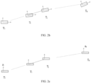
FIG. 2b is a schematic top view illustrating semantic elements according to an embodiment of the present disclosure; -
FIG. 2c is a schematic side view illustrating semantic elements according to an embodiment of the present disclosure; -
FIG. 3 is a flowchart illustrating steps of yet another map fusion method according to an embodiment of the present disclosure; -
FIG. 4 is a schematic diagram illustrating an instance of map fusion according to an embodiment of the present disclosure; and -
FIG. 5 is a schematic diagram illustrating a structure of a map fusion apparatus according to an embodiment of the present disclosure. - In order to make the above objectives, features, and advantages of the present disclosure more obvious and understandable, the present disclosure will be further described in detail below in conjunction with the accompanying drawings and specific implementations. Obviously, the described embodiments are only part of, not all of the embodiments of the present disclosure. Based on the embodiments of the present disclosure, all other embodiments obtained by those skilled in the art without paying creative efforts shall fall within the protection scope of the present disclosure, as long as those obtained embodiments are covered by the appended claims.
-
FIG. 1 is a flowchart illustrating steps of a map fusion method according to an embodiment of the present disclosure. Referring theFIG. 1 , the method specifically includes the following steps. - In
step 101, first three-dimensional map data and second three-dimensional map data are obtained. - The three-dimensional map data may be three-dimensional semantic map data containing multiple semantic elements, and the semantic element may be one of parking space information, speed bump information, roadblock information, lane line information, etc.
- As an example, the first three-dimensional map data and the second three-dimensional map data may be map data for a parking lot.
- When map fusion is performed, at least two pieces of three-dimensional map data preset in the vehicle for a target area may be acquired, at least two pieces of three-dimensional map data for a target area may also be acquired from a server; at least one piece of three-dimensional map data preset in the vehicle for a target area may also be acquired, and at least one piece of three-dimensional map data for a target area may also be acquired from the server. That is, the first three-dimensional map data and the second three-dimensional map data are acquired.
- In practical applications, a real-time map fusion can be performed in the in-vehicle computer, or a large number of map fusions can be performed in the server.
- In
step 102, for at least two first semantic elements in the first three-dimensional map data, at least two second semantic elements that match the at least two first semantic elements are determined in the second three-dimensional map data. - After at least two pieces of three-dimensional map data are obtained, at least two first semantic elements in any one piece of three-dimensional map data can be determined. For example, parking space information a and lane line information b in the first three-dimensional map data can be determined.
- After the two semantic elements are determined, the second semantic elements that match the first semantic elements can be determined in another piece of three-dimensional map data. For example, based on the parking space information a and the lane line information b in the first three-dimensional map data, parking space information A matching the parking space information a and the lane line information B matching the lane line information b are determined among the multiple semantic elements of the second three-dimensional map data.
- In
step 103, first relative information between the at least two first semantic elements is determined, and second relative information between the at least two second semantic elements is determined. - Relative information may be two-dimensional or three-dimensional relative information between two semantic elements.
- After the matching semantic elements are determined, the two-dimensional information and three-dimensional information of a semantic element can be determined. For example, a three-dimensional coordinate system in any piece of three-dimensional map data can be determined, such that coordinate information of the semantic element in the three-dimensional map data can be determined based on the coordinate system, and the two-dimensional information and three-dimensional information of the semantic element can be determined based on the coordinate information.
- After the two-dimensional information and the three-dimensional information of the semantic element are determined, the two-dimensional relative information and the three-dimensional relative information of two semantic elements can be determined based on the two-dimensional information and the three-dimensional information of each of the two semantic elements, so as to obtain the first relative information of the first semantic element and the second relative information of the second semantic element.
- For example, the two-dimensional information and the three-dimensional information of the parking space information a can be determined, and the two-dimensional information and the three-dimensional information of the lane line information b can be determined, such that the two-dimensional relative information and the three-dimensional relative information of the parking space information a and the lane line information b, i.e., the first relative information, can be determined.
- In
step 104, the first three-dimensional map data and the second three-dimensional map data are optimized based on the first relative information and the second relative information; - After the first relative information and the second relative information are obtained, based on the first relative information and the second relative information, the relative relationship between the first semantic elements and the relative relationship between the second semantic elements can be determined, and errors between the first semantic elements and the second semantic elements can be determined, for example, an error between the two-dimensional information of the parking space information a and the two-dimensional information of the parking space information A, or an error between the two-dimensional relative information of the parking space information a and the lane line information b and the two-dimensional relative information of the parking space information A and the lane line information B.
- After the relative relationship and the errors between the first semantic elements and the second semantic elements are determined, the two-dimensional information and the three-dimensional information of the semantic element can be optimized and adjusted based on the relative relationship and the errors.
- In
step 105, a map fusion is performed on the optimized first three-dimensional map data and the optimized second three-dimensional map data. - After the three-dimensional map data is optimized, the number of fusions of different three-dimensional map data can be determined, and thus at least two piece of three-dimensional map data can be weighted and fused according to the different number of fusions.
- In practical applications, since a large number of maps can be fused, there will be maps that have been fused multiple times. By determining the number of fusions of the map, and determining the difficulty of map fusion according to the number of fusions, the three-dimensional map data can be weighted and fused according to the difficulty, thereby improving the accuracy of the three-dimensional map fusion, and allowing the fused map to be more accurate.
- In the embodiments of the present disclosure, by obtaining the first three-dimensional map data and the second three-dimensional map data, for at least two first semantic elements in the first three-dimensional map data, at least two second semantic elements that match the at least two first semantic elements are determined in the second three-dimensional map data; the first relative information between the at least two first semantic elements is determined, and the second relative information between the at least two second semantic elements is determined; the first three-dimensional map data and the second three-dimensional map data are optimized based on the first relative information and the second relative information; and the map fusion is performed on the optimized first three-dimensional map data and the optimized second three-dimensional map data. In this way, the three-dimensional map data can be optimized, the process of map fusion is simplified, the amount of calculation is reduced, and the accuracy and efficiency of map fusion are improved.
-
FIG. 2a is a flowchart illustrating steps of another map fusion method according to an embodiment of the present disclosure. Referring toFIG. 2a , the map fusion method specifically includes the following steps. - In
step 201, first three-dimensional map data and second three-dimensional map data are obtained. - In
step 202, for at least two first semantic elements in the first three-dimensional map data, at least two second semantic elements that match the at least two first semantic elements are determined in the second three-dimensional map data. - In
step 103, first relative information between the at least two first semantic elements is determined, and second relative information between the at least two second semantic elements is determined. - The first relative information may include first two-dimensional relative information and first three-dimensional relative information, and the second relative information may include second two-dimensional relative information and second three-dimensional relative information.
- After the matching semantic elements are determined, the two-dimensional information of the semantic element, such as pose information, and the three-dimensional information of the semantic element, such as height information, can be determined.
- For example, a three-dimensional coordinate system in any piece of three-dimensional map data can be determined, such that coordinate information of the semantic element in the three-dimensional map data can be determined based on the coordinate system, and the pose information and height information of the semantic element can be determined based on the coordinate information.
- In practical applications, rotation information relative to x-axis and rotation information relative to y-axis of the semantic element can also be determined, and the rotation of the semantic element can be optimized based on the rotation information relative to x-axis and the rotation information relative to y-axis.
- However, since the semantic element do not have large errors in terms of the rotation information relative to x-axis and the rotation information relative to y-axis, the optimization of the rotation information will not bring greater improvements to the quality of map fusion. In addition, the optimization of the rotation information has a large amount of calculation, complex processing methods, and high hardware requirements. Therefore, by only optimizing the height information of the semantic element, the optimization process is simplified, the amount of calculation is reduced, and the accuracy of height optimization can be improved by determining information such as the relative height information, height error value, etc.
- After the pose information and height information of the semantic element are determined, the two-dimensional relative information between the two semantic elements can be determined based on the pose information of each of the two semantic elements, and the three-dimensional relative information between the two semantic elements can be determined based on the height information of each of the two semantic elements.
- As illustrated in
FIG. 2b , the pose information of a semantic element 1 to a semantic element n may include position information and angle information, and the position information and angle information of the semantic element may be determined based on the coordinate information, such that the position information and angle information can be transformed into the pose information of the semantic element, specifically through the following matrixes :

- In an embodiment of the present disclosure, the height information of the semantic element 1 to the semantic element n may be as illustrated in
FIG. 2c , and the height information of the semantic element may be determined based on the coordinate information, where z1 may be expressed as height information of the semantic element 1. - In
step 204, target information of the at least two first semantic elements and the at least two second semantic elements is determined based on the first relative information and the second relative information. - The target information may include target two-dimensional information and target three-dimensional information.
- After the two-dimensional relative information and the three-dimensional relative information are obtained, based on the two-dimensional relative information and the three-dimensional relative information, the relative relationship between the first semantic elements and the relative relationship between the second semantic elements can be determined, and errors between the first semantic elements and the second semantic elements can be determined, for example, an error between the two-dimensional information of the parking space information a and the two-dimensional information of the parking space information A, and an error between the two-dimensional relative information of the parking space information a and the lane line information b and the two-dimensional relative information of the parking space information A and the lane line information B.
- After the relative relationship and the errors between the first semantic elements and the second semantic elements are determined, based on the relative relationship and the errors, the target two-dimensional information and the target three-dimensional information of the first semantic element can be determined, and the target two-dimensional information and the target three-dimensional information of the second semantic element can be determined.
- In an embodiment of the present disclosure, the first two-dimensional relative information may include first relative pose information, the second two-dimensional relative information may include second relative pose information, and the target two-dimensional information may be target pose information. Step 204 may include the following sub-steps:
- In sub-step 11, a pose error value is determined based on the first relative pose information and the second relative pose information.
- The pose error value may be a value of a relative pose error between the first relative pose information and the second relative pose information.
- After the pose information of the semantic element is determined, the relative pose information between two semantic elements can be determined based on the pose information of each of the two semantic elements. Specifically, the relative pose information can be determined through the following matrix:


- In an embodiment of the present disclosure, when the semantic element i and the semantic element j are any two semantic elements in the same three-dimensional map data, the relative pose information of the two semantic elements may be Tij, and before optimization, the relative pose information between the two semantic elements can be distinguished from Tij by wavy lines, which can be specifically expressed as the following matrix:

- In an embodiment of the present disclosure, when the semantic element i and the semantic element j are matching semantic elements in at least two pieces of three-dimensional map data, the relative pose information of the two semantic elements may be Tij, but T̃ij may be an identity matrix, which can be specifically expressed as follows matrix:

- After the relative pose information is determined, the pose error value can be determined based on the relative pose information. Specifically, the pose error value can be determined through the following matrix:


- After the matrix (6) is determined, the matrix (6) can be converted into the following matrix:

- In an embodiment of the present disclosure, when the semantic element i and the semantic element j are any two semantic elements in the same three-dimensional map data, eij can also be expressed as a pose error value of the first relative pose information or the second relative pose information.
- In sub-step 12, based on the pose error value, an association between pose information of the at least two first semantic elements and the at least two second semantic elements and a relative pose error.
- The relative pose error and the pose information may be independent variables in the association, or the relative pose error may be a dependent variable in the association, and the pose error value is a known value of the relative pose error.
- After the pose error value is determined, based on the relative pose error as well as the corresponding first relative pose information and second relative pose information, the association between the relative pose error and the pose information of the first semantic elements and/or the second semantic elements is determined. The association can be the following formula:


- In sub-step 13, under a premise of a minimum relative pose error, the target pose information of the at least two first semantic elements and the at least two second semantic elements is determined.
- After the association formula between the relative pose error and the pose information is determined, since the association formula can be expressed as the association between the relative pose error and the pose information, under a premise of a minimum relative pose error, the target pose information corresponding to the minimum relative pose error is determined.
- In practical applications, when the association formula is the smallest, i.e., when the value of f is the smallest, the corresponding first relative pose information and/or second relative pose information can be calculated, and thus the corresponding position information and angle information can be determined. The position information and the angle information can be determined by the following formula:


- In an embodiment of the present disclosure, the first three-dimensional relative information may include first relative height information, the second three-dimensional relative information may include second relative height information, and the target three-dimensional information may be target height information. Step 204 may include the following sub-steps.
- In
sub-step 21, a height error value is determined based on the first relative height information and the second relative height information. - The height error value may be an error value between the first relative height information and the second relative height information.
- After the height information of the semantic element is determined, any two semantic elements in one piece of the three-dimensional map data can be determined as a semantic element group, and the relative height information of any semantic element group can be determined based on the height information of the semantic elements. Similarly, the relative height information of any semantic element group in another piece of three-dimensional map data can also be determined, and the height error value can be determined based on the relative height information in different pieces of three-dimensional map data. The height error value can be determined by the following formula :

- In sub-step 22, based on the height error value, an association between the height information of the at least two first semantic elements and the at least two second semantic elements and a relative height error is determined.
- After the height error value is determined, based on the height error value as well as the corresponding first relative height information and second relative height information, the association between the relative height error and the height information of the first semantic elements and the second semantic elements is determined. The association can be the following formula:

- For example, e z1_12 may be expressed as the height error value of the first semantic element group in the first semantic elements and the first semantic element group in the second semantic elements, and the first semantic elements may include a semantic element 1 and a semantic element 2, i.e., the semantic element 1 and the semantic element 2 in the first semantic elements, and the semantic element 1 and the semantic element 2 in the second semantic elements.
- In sub-step 23, the target height information of the at least two first semantic elements and the at least two second semantic elements is determined under a premise of a minimum relative height error.
- After the association formula is determined, since the association formula can be expressed as an association between the relative height error and the height information, under a premise of a minimum relative height error, the corresponding first relative height information and second relative height information can be calculated when the association formula between the relative height error and the height information is the smallest, i.e., when the value of fz is the smallest, and thus the corresponding target height information can be determined. A minimum value of fz may be obtained by determining a gradient of the correlation formula, for example, when the gradient is 0, the value of fz is the smallest, and thus the target height information can be determined. Specifically, it can be calculated by the following formula:


- As an example, the gradient can be expressed by the following matrix:


- It can be known from the above gradient that


- In
step 205, the first three-dimensional map data and the second three-dimensional map data are optimized based on the target information of the at least two first semantic elements and the at least two second semantic elements. - After the target information, such as the target pose information and the target height information, is obtained, the pose information and height information of the semantic element can be optimized and adjusted based on the target information.
- In
step 206, a map fusion is performed on the optimized first three-dimensional map data and the optimized second three-dimensional map data. - In the embodiments of the present disclosure, by obtaining the first three-dimensional map data and the second three-dimensional map data, for at least two first semantic elements in the first three-dimensional map data, at least two second semantic elements that match the at least two first semantic elements are determined in the second three-dimensional map data; the first relative information between the at least two first semantic elements is determined, and the second relative information between the at least two second semantic elements is determined; the target information of the at least two first semantic elements and the at least two second semantic elements is determined based on the first relative information and the second relative information; the first three-dimensional map data and the second three-dimensional map data are optimized based on the target information of the at least two first semantic elements and the at least two second semantic elements, where the first relative information includes the first two-dimensional relative information and the first three-dimensional relative information, the second relative information includes the second two-dimensional relative information and the second three-dimensional relative information, and the target information includes the target two-dimensional information and the target three-dimensional information; and the map fusion is performed on the optimized first three-dimensional map data and the optimized second three-dimensional map data. In this way, the two-dimensional information and the three-dimensional information in the three-dimensional map data can be optimized, the process of map fusion is simplified, the amount of calculation is reduced, and the accuracy and efficiency of map fusion are improved.
-
FIG. 3 is a flowchart illustrating steps of yet another map fusion method according to an embodiment of the present disclosure. Referring toFIG. 3 , the map fusion method specifically includes the following steps. - In
step 301, first three-dimensional map data and second three-dimensional map data are obtained; - In
step 302, for at least two first semantic elements in the first three-dimensional map data, at least two second semantic elements that match the at least two first semantic elements are determined in the second three-dimensional map data; - In
step 303, a first conversion matrix for the first three-dimensional map data and a second conversion matrix for the second three-dimensional map data are determined based on the at least two first semantic elements and the at least two second semantic elements. - The conversion matrix may be a matrix used for overall adjustment of the semantic elements in the three-dimensional map data.
- After the matching semantic elements are determined, the position information of the matching semantic elements can be determined in different pieces of three-dimensional map data, such that the overall position information of the semantic elements in any piece of three-dimensional map data can be determined based on the position information of all the matching semantic elements in this piece of three-dimensional map data. Similarly, another overall position information can be determined in another piece of three-dimensional map data, and the conversion matrixes for different pieces of three-dimensional map data can be generated based on the different overall position information.
- In
step 304, the first three-dimensional map data is adjusted by using the first conversion matrix, and the second three-dimensional map data is adjusted by using the second conversion matrix. - After the conversion matrix is determined, the corresponding conversion matrix may be used to perform an overall weight adjustment on the different pieces of three-dimensional map data, such as the adjustment of overall position information.
- The overall weight adjustment may include an adjustment of the position information of the matching semantic elements and an adjustment of the position information of other unmatching semantic elements.
- In practical applications, at least two pieces of three-dimensional map data can be directly used for fusion to generate a topological three-dimensional map with multiple layers, and the three-dimensional map data of different layers can be adjusted based on the corresponding conversion matrixes, so as to obtain three-dimensional maps that overlap as much as possible.
- In
step 305, first relative information between the at least two first semantic elements is determined, and second relative information between the at least two second semantic elements is determined. - In
step 306, the first three-dimensional map data and the second three-dimensional map data are optimized based on the first relative information and the second relative information. - In
step 307, a map fusion is performed on the optimized first three-dimensional map data and the optimized second three-dimensional map data. - In
step 308, a third semantic element in the first three-dimensional map data is determined, where no semantic element in the second three-dimensional map data matches the third semantic element. - When performing the map fusion, any one piece of the three-dimensional map data is used as a reference, and another piece of three-dimensional map data is fused into this piece of three-dimensional map data. For example, the three-dimensional map data B can be determined as a reference, and the three-dimensional map data A is fused into the three-dimensional map data B. Thus, after performing the map fusion on the optimized three-dimensional map data, the semantic element in the other piece of three-dimensional map data that fails to match the semantic element in this piece of three-dimensional map data can be determined. For example, the semantic element in the three-dimensional map data A that fails to match the semantic element in the three-dimensional map data B can be determined.
- In
step 309, the third semantic element is added to the map-fused second three-dimensional map data. - After the third semantic element is determined, since the third semantic element is a semantic element that fails to match the semantic element in the second three-dimensional map data, the third semantic element can be added to the second three-dimensional map data.
- For example, as the semantic element in the three-dimensional map data A that fails to match the semantic element in the three-dimensional map data B can be determined, the unmatching semantic element can be added to the three-dimensional map data B.
- In the embodiments of the present disclosure, by obtaining the first three-dimensional map data and the second three-dimensional map data, for at least two first semantic elements in the first three-dimensional map data, at least two second semantic elements that match the at least two first semantic elements are determined in the second three-dimensional map data; the first conversion matrix for the first three-dimensional map data and the second conversion matrix for the second three-dimensional map data are determined based on the at least two first semantic elements and the at least two second semantic elements; the first three-dimensional map data is adjusted by using the first conversion matrix, and the second three-dimensional map data is adjusted by using the second conversion matrix; the first relative information between the at least two first semantic elements is determined, and the second relative information between the at least two second semantic elements is determined; the first three-dimensional map data and the second three-dimensional map data are optimized based on the first relative information and the second relative information; the map fusion is performed on the optimized first three-dimensional map data and the optimized second three-dimensional map data; the third semantic element in the first three-dimensional map data is determined, where no semantic element in the second three-dimensional map data matches the third semantic element; and the third semantic element is added to the map-fused second three-dimensional map data. In this way, the three-dimensional map data can be adjusted and optimized, the process of map fusion is simplified, the amount of calculation is reduced, and the accuracy and efficiency of map fusion are improved.
- The embodiments of the present disclosure are illustratively described below in conjunction with
FIG. 4 . - 1. When performing the map fusion, at least two pieces of three-dimensional map data can be obtained, at least two semantic elements in the first three-dimensional map data can be determined, and after these two semantic elements are determined, it is determined whether there are semantic elements in the second three-dimensional map data that match the semantic elements in the first three-dimensional map data;
- 2. If there are semantic elements in another piece of three-dimensional map data that match the first semantic elements, step 3 is performed; and if there are no matching semantic element in another piece of three-dimensional map data, steps 2 to 6 are skipped and step 7 is directly performed.
- 3. After the matching semantic elements are determined, the overall position information of the matching semantic elements can be determined in different pieces of three-dimensional map data, and then the conversion matrixes for the different pieces of three-dimensional map data can be generated based on the different overall position information. After the conversion matrixes are determined, the corresponding conversion matrixes can be used to adjust the different pieces of three-dimensional map data as a whole.
- 4. After the adjusted three-dimensional map data is obtained, the relative pose information between the two semantic elements can be determined based on the position information and angle information of the semantic elements, and the value of the relative pose error, i.e., the pose error value, can be determined based on the relative pose information. Thus, the association between pose information and relative pose error can be determined based on the relative pose information and the pose error value, and under a premise of a minimum relative pose error, the target pose information is determined to perform a plane pose optimization.
- 5. After performing the plane pose optimization, the relative height information between the two semantic elements can be determined based on the height information of the semantic elements, and the height error value can be determined based on the relative height information. Thus, the association between height information and relative height error can be determined based on the relative height information and the height error value, and under a premise of a minimum relative height error, the target pose information is determined to perform a height optimization.
- 6. After the three-dimensional map data is optimized, the number of fusions of different three-dimensional map data can be determined, and then at least two pieces of three-dimensional map data can be weighted and fused based on the different number of fusions.
- 7. The unmatching semantic elements in the two pieces of three-dimensional map data are fused, that is, the semantic element of one piece of three-dimensional map data is added to the other piece of three-dimensional map data.
- It should be noted that, for the sake of simple description, the embodiments involving the method are all expressed as a series of actions in combination. However, those skilled in the art should know that the embodiments of the present disclosure are not limited by the order of the actions as described. According to the embodiments of the present disclosure, certain steps can be performed in other orders or simultaneously. In addition, those skilled in the art should also know that the embodiments described in the specification are all preferred embodiments, and the actions involved are not necessarily required by the embodiments of the present disclosure.
-
FIG. 5 is a schematic diagram illustrating a structure of a map fusion apparatus according to an embodiment of the present disclosure. Referring toFIG. 5 , the map fusion apparatus specifically includes: a three-dimensional mapdata obtaining module 501, a semanticelement determining module 502, a relativeinformation determining module 503, anoptimization module 504, and a fusion module 505. - The three-dimensional map
data obtaining module 501 is configured to obtain first three-dimensional map data and second three-dimensional map data. - The semantic
element determining module 502 is configured to determine, for at least two first semantic elements in the first three-dimensional map data, at least two second semantic elements that match the at least two first semantic elements in the second three-dimensional map data. - The relative
information determining module 503 is configured to determine first relative information between the at least two first semantic elements, and determine second relative information between the at least two second semantic elements;
Theoptimization module 504 is configured to optimize the first three-dimensional map data and the second three-dimensional map data based on the first relative information and the second relative information. - The fusion module 505 is configured to perform a map fusion on the optimized first three-dimensional map data and the optimized second three-dimensional map data.
- In an embodiment of the present disclosure, the
optimization module 504 includes: a target information determining sub-module configured to determine target information of the at least two first semantic elements and the at least two second semantic elements based on the first relative information and the second relative information; and a three-dimensional map data optimization sub-module configured to optimize the first three-dimensional map data and the second three-dimensional map data based on the target information of the at least two first semantic elements and the at least two second semantic elements, where the first relative information includes first two-dimensional relative information and first three-dimensional relative information, the second relative information includes second two-dimensional relative information and second three-dimensional relative information, and the target information includes target two-dimensional information and target three-dimensional information. - In an embodiment of the present disclosure, the first two-dimensional relative information includes first relative pose information, the second two-dimensional relative information includes second relative pose information, and the target two-dimensional information is target pose information; and the target information determining sub-module includes: a pose error determining unit configured to determine a pose error value based on the first relative pose information and the second relative pose information; a relative pose error association determining unit configured to determine, based on the pose error value, an association between pose information of the at least two first semantic elements and the at least two second semantic elements and a relative pose error; and a target pose information determining unit configured to determine the target pose information of the at least two first semantic elements and the at least two second semantic elements under a premise of a minimum relative pose error.
- In an embodiment of the present disclosure, the first two-dimensional relative information includes first relative height information, the second two-dimensional relative information includes second relative height information, and the target two-dimensional information is target height information; and the target information determining sub-module includes: a height error determining unit configured to determine a height error value based on the first relative height information and the second relative height information; a relative height error association determining unit configured to determine, based on the height error value, an association between height information of the at least two first semantic elements and the at least two second semantic elements and a relative height error; and a target height information determining unit configured to determine the target height information of the at least two first semantic elements and the at least two second semantic elements under a premise of a minimum relative height error.
- In an embodiment of the present disclosure, the apparatus further includes a conversion matrix determining module configured to determine a first conversion matrix for the first three-dimensional map data and a second conversion matrix for the second three-dimensional map data based on the at least two first semantic elements and the at least two second semantic elements; and a three-dimensional map data adjustment module configured to adjust the first three-dimensional map data by using the first conversion matrix, and adjust the second three-dimensional map data by using the second conversion matrix.
- In an embodiment of the present disclosure, the apparatus further includes a third semantic element determining module configured to determine a third semantic element in the first three-dimensional map data, where no matching semantic element in the second three-dimensional map data matches the third semantic element; and a third semantic element fusing module configured to add the third semantic element to the map-fused second three-dimensional map data.
- In the embodiments of the present disclosure, by obtaining the first three-dimensional map data and the second three-dimensional map data, for at least two first semantic elements in the first three-dimensional map data, at least two second semantic elements that match the at least two first semantic elements are determined in the second three-dimensional map data; the first conversion matrix for the first three-dimensional map data and the second conversion matrix for the second three-dimensional map data are determined based on the at least two first semantic elements and the at least two second semantic elements; the first three-dimensional map data is adjusted by using the first conversion matrix, and the second three-dimensional map data is adjusted by using the second conversion matrix; the first relative information between the at least two first semantic elements is determined, and the second relative information between the at least two second semantic elements is determined; based on the first relative information and the second relative information, the target information of the at least two first semantic elements and the at least two second semantic elements is determined; based on the target information of the at least two first semantic elements and the at least two second semantic elements, the first three-dimensional map data and the second three-dimensional map data are optimized, where the first relative information includes the first two-dimensional relative information and the first three-dimensional relative information, the second relative information includes the second two-dimensional relative information and the second three-dimensional relative information, and the target information includes the target two-dimensional information and the target three-dimensional information; and the map fusion is performed on the optimized first three-dimensional map data and the optimized second three-dimensional map data; the third semantic element in the first three-dimensional map data is determined, and the third semantic element is added to the map-fused second three-dimensional map data. In this way, it is achieved that the two-dimensional information and the three-dimensional information in the three-dimensional map data are adjusted and optimized, the process of map fusion is simplified, the amount of calculation is reduced, and the accuracy and efficiency of map fusion are improved.
- An embodiment of the present disclosure further provides a server, which may include a processor, a memory, and a computer program stored on the memory and executable on the processor. The computer program, when executed by the processor, implements the map fusion method as described above.
- An embodiment of the present disclosure further provides a computer-readable storage medium having a computer program stored thereon. The computer program, when executed by the processor, implements the map fusion method as described above.
- Since the apparatus embodiments are basically similar to the method embodiments, the description of the apparatus embodiments is relatively simple. For related description, reference may be made to a corresponding part of the description of the method embodiments.
- Each embodiment in the specification is described in a progressive manner. Each embodiment focuses on the differences from other embodiments. The same or similar parts of various embodiments can be referred to each other.
- Those skilled in the art should understand that the embodiments of the present disclosure can be provided as a method, an apparatus, or a computer program product. Accordingly, the embodiments of the present disclosure may adopt a form of a complete hardware embodiment, a complete software embodiment, or an embodiment combining software and hardware. In addition, the embodiments of the present disclosure may adopt a form of computer program products implemented on one or more computer-usable storage media (including but not limited to disk storage, Compact Disc Read-Only Memory (CD-ROM), optical storage, etc.) including computer-usable program codes.
- The embodiments of the present disclosure are described with reference to flowcharts and/or block diagrams of the methods, the terminal device (system), and the computer program product according to the embodiments of the present disclosure. It should be understood that each process and/or block in the flowcharts and/or block diagrams, and a combination of processes and/or blocks in the flowcharts and/or block diagrams can be realized by computer program instructions. These computer program instructions can be provided to a processor of a general-purpose computer, a special-purpose computer, an embedded processor, or other programmable data processing terminal devices to generate a machine, such that instructions executed by the processor of the computer or other programmable data processing terminal devices generate an apparatus for implementing functions specified in one or more processes in the flowchart and/or one or more blocks in the block diagram.
- These computer program instructions can also be stored in a computer-readable memory that can guide a computer or other programmable data processing terminal device to work in a specific manner, such that the instructions stored in the computer-readable memory produce an article of manufacture including an instruction device. The instruction device implements functions specified in one or more processes in the flowchart and/or one or more blocks in the block diagram.
- These computer program instructions can also be loaded on a computer or other programmable data processing terminal devices, so that a series of operation steps are executed on the computer or other programmable terminal devices to generate computer-implemented processing. Thus, the instructions executed on the computer or other programmable terminal devices provide steps for implementing functions specified in one or more processes in the flowchart and/or one or more blocks in the block diagram.
- Although the preferred embodiments of the present disclosure have been described above, those skilled in the art can make additional changes and modifications to these embodiments once they learn the basic creative concept.
- It should be noted that, in the present disclosure, relational terms herein, such as "first" and "second" are merely used to distinguish one entity or operation from another entity or operation, which, however do not necessarily require or imply that there should be any actual relationship or sequence between these entities or operations. Moreover, the terms "comprise", "include", or any other variants thereof are meant to cover non-exclusive including, such that the process, method, article or terminal device including a series of elements do not only include those elements, but also include other elements that are not explicitly listed, or also include inherent elements of the process, method, article or terminal device. Without specific limitations, an qualified defined by the statement "comprises a ..." does not exclude the presence of additional identical elements in the process, method, article, or terminal device that includes said element.
- The map fusion method, the map fusion apparatus, the server, and the storage medium provided above are described in detail above. Specific examples are used herein to illustrate the principles and implementations of the present disclosure.
Claims (11)
- A computer-implemented map fusion method, comprising:obtaining (S101) first three-dimensional map data and second three-dimensional map data;determining (S102), for at least two first semantic elements in the first three-dimensional map data, at least two second semantic elements in the second three-dimensional map data that match the at least two first semantic elements;determining (S103) first relative information between the at least two first semantic elements, and determining (S103) second relative information between the at least two second semantic elements;optimizing (S104) the first three-dimensional map data and the second three-dimensional map data based on the first relative information and the second relative information; andperforming (S105) a map fusion on the optimized first three-dimensional map data and the optimized second three-dimensional map data,wherein said optimizing (S104) the first three-dimensional map data and the second three-dimensional map data based on the first relative information and the second relative information comprises:determining (S204) target information of the at least two first semantic elements and the at least two second semantic elements based on the first relative information and the second relative information; andoptimizing (S205) the first three-dimensional map data and the second three-dimensional map data based on the target information of the at least two first semantic elements and the at least two second semantic elements,wherein the first relative information comprises first two-dimensional relative information and first three-dimensional relative information, the second relative information comprises second two-dimensional relative information and second three-dimensional relative information, and the target information comprises target two-dimensional information and target three-dimensional information, characterized in that, the first two-dimensional relative information comprises first relative pose information, the second two-dimensional relative information comprises second relative pose information, and the target two-dimensional information is target pose information, andwherein said determining (S204) the target information of the at least two first semantic elements and the at least two second semantic elements based on the first relative information and the second relative information comprises:determining a pose error value based on the first relative pose information and the second relative pose information;determining, based on the pose error value, an association between pose information of the at least two first semantic elements and the at least two second semantic elements and a relative pose error; anddetermining the target pose information of the at least two first semantic elements and the at least two second semantic elements under a premise of a minimum relative pose error.
- The method according to claim 1, wherein the first three-dimensional relative information comprises first relative height information, the second three-dimensional relative information comprises second relative height information, and the target three-dimensional information is target height information; and
wherein said determining (S204) the target information of the at least two first semantic elements and the at least two second semantic elements based on the first relative information and the second relative information comprises:determining a height error value based on the first relative height information and the second relative height information;determining, based on the height error value, an association between height information of the at least two first semantic elements and the at least two second semantic elements and a relative height error; anddetermining target height information of the at least two first semantic elements and the at least two second semantic elements under a premise of a minimum relative height error. - The method according to claim 1, further comprising, prior to said determining (S103) first relative information between the at least two first semantic elements and said determining (S103) second relative information between the at least two second semantic elements:determining (S303) a first conversion matrix for the first three-dimensional map data and a second conversion matrix for the second three-dimensional map data based on the at least two first semantic elements and the at least two second semantic elements; andadjusting (S304) the first three-dimensional map data by using the first conversion matrix, and adjusting the second three-dimensional map data by using the second conversion matrix.
- The method according to claim 1, further comprising:determining (S308) a third semantic element in the first three-dimensional map data, wherein no semantic element in the second three-dimensional map data matches the third semantic element; andadding (S309) the third semantic element to the map-fused second three-dimensional map data.
- The method according to claim 1, wherein the first three-dimensional map data and the second three-dimensional map data are map data for a parking lot.
- A map fusion apparatus, comprising:a three-dimensional map data obtaining module (501) configured to obtain first three-dimensional map data and second three-dimensional map data;a semantic element determining module (502) configured to determine, for at least two first semantic elements in the first three-dimensional map data, at least two second semantic elements in the second three-dimensional map data that match the at least two first semantic elements;a relative information determining module (503) configured to determine first relative information between the at least two first semantic elements, and determine second relative information between the at least two second semantic elements;an optimization module (504) configured to optimize the first three-dimensional map data and the second three-dimensional map data based on the first relative information and the second relative information; anda fusion module (505) configured to perform a map fusion on the optimized first three-dimensional map data and the optimized second three-dimensional map data,wherein the optimization module (504) comprises:a target information determining sub-module configured to determine target information of the at least two first semantic elements and the at least two second semantic elements based on the first relative information and the second relative information; anda three-dimensional map data optimization sub-module configured to optimize the first three-dimensional map data and the second three-dimensional map data based on the target information of the at least two first semantic elements and the at least two second semantic elements,wherein the first relative information comprises first two-dimensional relative information and first three-dimensional relative information, the second relative information comprises second two-dimensional relative information and second three-dimensional relative information, and the target information comprises target two-dimensional information and target three-dimensional information, characterized in that, the first two-dimensional relative information comprises first relative pose information, the second two-dimensional relative information comprises second relative pose information, and the target two-dimensional information is target pose information, andwherein the target information determining sub-module comprises:a pose error determining unit configured to determine a pose error value based on the first relative pose information and the second relative pose information;a relative pose error association determining unit configured to determine, based on the pose error value, an association between pose information of the at least two first semantic elements and the at least two second semantic elements and a relative pose error; anda target pose information determining unit configured to determine the target pose information of the at least two first semantic elements and the at least two second semantic elements under a premise of a minimum relative pose error.
- The apparatus according to claim 6, wherein the first three-dimensional relative information comprises first relative height information, the second three-dimensional relative information comprises second relative height information, and the target three-dimensional information is target height information; and
wherein the target information determining sub-module comprises:a height error determining unit configured to determine a height error value based on the first relative height information and the second relative height information;a relative height error association determining unit configured to determine, based on the height error value, an association between height information of the at least two first semantic elements and the at least two second semantic elements and a relative height error; anda target height information determining unit configured to determine target height information of the at least two first semantic elements and the at least two second semantic elements under a premise of a minimum relative height error. - The apparatus according to claim 6, further comprising:a conversion matrix determining module configured to determine a first conversion matrix for the first three-dimensional map data and a second conversion matrix for the second three-dimensional map data based on the at least two first semantic elements and the at least two second semantic elements; anda three-dimensional map data adjustment module configured to adjust the first three-dimensional map data by using the first conversion matrix, and adjusting the second three-dimensional map data by using the second conversion matrix.
- The apparatus according to claim 6, further comprising:a third semantic element determining module configured to determine a third semantic element in the first three-dimensional map data, wherein no semantic element in the second three-dimensional map data matches the third semantic element; anda third semantic element fusing module configured to add the third semantic element to the map-fused second three-dimensional map data.
- A server, comprising a processor, a memory, and a computer program stored on the memory and executable on the processor, characterized in that the computer program, when executed by the processor, causes the processor to implement the map fusion method according to any one of claims 1 to 5.
- A computer-readable storage medium, having a computer program stored thereon, characterized in that the computer program, when executed by a processor, causes the processor to implement the map fusion method according to any one of claims 1 to 5.
Applications Claiming Priority (2)
| Application Number | Priority Date | Filing Date | Title |
|---|---|---|---|
| CN202011224448.3A CN112308810B (en) | 2020-11-05 | 2020-11-05 | Map fusion method and device, server and storage medium |
| PCT/CN2021/102343 WO2022095473A1 (en) | 2020-11-05 | 2021-06-25 | Method and apparatus for map fusion, server and storage medium |
Publications (4)
| Publication Number | Publication Date |
|---|---|
| EP4024328A1 EP4024328A1 (en) | 2022-07-06 |
| EP4024328A4 EP4024328A4 (en) | 2022-07-27 |
| EP4024328B1 true EP4024328B1 (en) | 2023-07-12 |
| EP4024328C0 EP4024328C0 (en) | 2023-07-12 |
Family
ID=74325147
Family Applications (1)
| Application Number | Title | Priority Date | Filing Date |
|---|---|---|---|
| EP21791231.0A Active EP4024328B1 (en) | 2020-11-05 | 2021-06-25 | Method and apparatus for map fusion, server and storage medium |
Country Status (3)
| Country | Link |
|---|---|
| EP (1) | EP4024328B1 (en) |
| CN (1) | CN112308810B (en) |
| WO (1) | WO2022095473A1 (en) |
Families Citing this family (7)
| Publication number | Priority date | Publication date | Assignee | Title |
|---|---|---|---|---|
| CN112308810B (en) * | 2020-11-05 | 2022-05-13 | 广州小鹏自动驾驶科技有限公司 | Map fusion method and device, server and storage medium |
| CN112836003A (en) * | 2021-02-04 | 2021-05-25 | 广州小鹏自动驾驶科技有限公司 | A map processing method and device |
| CN113656525B (en) * | 2021-08-19 | 2024-04-16 | 广州小鹏自动驾驶科技有限公司 | A method and device for map processing |
| CN114088082B (en) * | 2021-11-01 | 2024-04-16 | 广州小鹏自动驾驶科技有限公司 | A method and device for processing map data |
| CN114061564B (en) * | 2021-11-01 | 2022-12-13 | 广州小鹏自动驾驶科技有限公司 | Map data processing method and device |
| CN116202538B (en) * | 2023-05-05 | 2023-08-29 | 广州小鹏自动驾驶科技有限公司 | Map matching fusion method, device, equipment and storage medium |
| CN119323646B (en) * | 2024-12-19 | 2025-04-01 | 烟台大学 | Three-dimensional lane line generation method and system integrating context semantic information |
Family Cites Families (14)
| Publication number | Priority date | Publication date | Assignee | Title |
|---|---|---|---|---|
| US8983774B2 (en) * | 2013-07-09 | 2015-03-17 | Qualcomm Incorporated | Intelligent map combination for venues enabling indoor positioning |
| CN107145578B (en) * | 2017-05-08 | 2020-04-10 | 深圳地平线机器人科技有限公司 | Map construction method, device, equipment and system |
| CN107144285B (en) * | 2017-05-08 | 2020-06-26 | 深圳地平线机器人科技有限公司 | Pose information determination method and device and movable equipment |
| US10812711B2 (en) * | 2018-05-18 | 2020-10-20 | Samsung Electronics Co., Ltd. | Semantic mapping for low-power augmented reality using dynamic vision sensor |
| US10991156B2 (en) * | 2018-12-05 | 2021-04-27 | Sri International | Multi-modal data fusion for enhanced 3D perception for platforms |
| CN109920055A (en) * | 2019-03-08 | 2019-06-21 | 视辰信息科技(上海)有限公司 | Construction method, device and the electronic equipment of 3D vision map |
| CN110163963B (en) * | 2019-04-12 | 2023-06-20 | 南京华捷艾米软件科技有限公司 | Mapping device and mapping method based on SLAM |
| CN110288710B (en) * | 2019-06-26 | 2023-04-07 | Oppo广东移动通信有限公司 | Three-dimensional map processing method and device and terminal equipment |
| CN111060117B (en) * | 2019-12-17 | 2022-02-08 | 苏州智加科技有限公司 | Local map construction method and device, computer equipment and storage medium |
| CN111174799B (en) * | 2019-12-24 | 2023-02-17 | Oppo广东移动通信有限公司 | Map construction method and device, computer readable medium and terminal equipment |
| CN111797187B (en) * | 2020-06-22 | 2023-09-26 | 北京百度网讯科技有限公司 | Map data update method, device, electronic device and storage medium |
| CN111831771B (en) * | 2020-07-09 | 2024-03-12 | 广州小鹏自动驾驶科技有限公司 | A map fusion method and vehicle |
| CN111831776B (en) * | 2020-07-16 | 2022-03-11 | 广州小鹏自动驾驶科技有限公司 | Map fusion method, vehicle, electronic equipment and storage medium |
| CN112308810B (en) * | 2020-11-05 | 2022-05-13 | 广州小鹏自动驾驶科技有限公司 | Map fusion method and device, server and storage medium |
-
2020
- 2020-11-05 CN CN202011224448.3A patent/CN112308810B/en active Active
-
2021
- 2021-06-25 WO PCT/CN2021/102343 patent/WO2022095473A1/en not_active Ceased
- 2021-06-25 EP EP21791231.0A patent/EP4024328B1/en active Active
Also Published As
| Publication number | Publication date |
|---|---|
| EP4024328C0 (en) | 2023-07-12 |
| CN112308810B (en) | 2022-05-13 |
| EP4024328A4 (en) | 2022-07-27 |
| EP4024328A1 (en) | 2022-07-06 |
| WO2022095473A1 (en) | 2022-05-12 |
| CN112308810A (en) | 2021-02-02 |
Similar Documents
| Publication | Publication Date | Title |
|---|---|---|
| EP4024328A1 (en) | Method and apparatus for map fusion, server and storage medium | |
| Liao et al. | Maptrv2: An end-to-end framework for online vectorized hd map construction | |
| CN114677663B (en) | Vehicle positioning method, device, electronic device, and computer-readable storage medium | |
| EP3109842B1 (en) | Map-centric map matching method and apparatus | |
| CN110189366B (en) | A laser rough registration method, device, mobile terminal and storage medium | |
| CN113343875B (en) | A drivable area perception method for robots | |
| JP2019144538A (en) | Method of updating electronic map, device thereof, and computer-readable storage medium thereof | |
| CN105652876A (en) | Mobile robot indoor route planning method based on array map | |
| EP4184119B1 (en) | Travelable region determination method, intelligent driving system and intelligent vehicle | |
| CN113191342A (en) | Lane positioning method and electronic equipment | |
| CN114283397B (en) | Global relocation method, device, equipment and storage medium | |
| CN117541910A (en) | Fusion method and device of multiple lightning vision data on urban roads | |
| CN109764876A (en) | The multi-modal fusion localization method of unmanned platform | |
| CN117824667A (en) | A fusion positioning method and medium based on two-dimensional code and laser | |
| EP4459232A1 (en) | Map matching and merging method, device, apparatus and storage medium | |
| EP3968177A1 (en) | Map fusion method and vehicle, electronic device, and storage medium | |
| Tang et al. | Autonomous indoor mobile robot exploration based on wavefront algorithm | |
| CN107831496A (en) | The method and system of vehicle speed before a kind of intelligent automobile obtains automatically | |
| CN112415524A (en) | Robot and its positioning and navigation method and device | |
| CN119881991A (en) | Beidou mapping system positioning device and method | |
| CN111238524B (en) | Visual positioning method and device | |
| CN118424256A (en) | A distributed multi-resolution map fusion mapping and positioning method and device | |
| CN117268371A (en) | A processing method, device and processing equipment for automatic driving teaching trajectory in a driving school | |
| Miao et al. | Efficient End-to-end Visual Localization for Autonomous Driving with Decoupled BEV Neural Matching | |
| CN115482262A (en) | Multi-intelligent reinforcement learning-based natural image geometric registration method and model |
Legal Events
| Date | Code | Title | Description |
|---|---|---|---|
| STAA | Information on the status of an ep patent application or granted ep patent |
Free format text: STATUS: UNKNOWN |
|
| STAA | Information on the status of an ep patent application or granted ep patent |
Free format text: STATUS: THE INTERNATIONAL PUBLICATION HAS BEEN MADE |
|
| PUAI | Public reference made under article 153(3) epc to a published international application that has entered the european phase |
Free format text: ORIGINAL CODE: 0009012 |
|
| STAA | Information on the status of an ep patent application or granted ep patent |
Free format text: STATUS: REQUEST FOR EXAMINATION WAS MADE |
|
| 17P | Request for examination filed |
Effective date: 20211029 |
|
| AK | Designated contracting states |
Kind code of ref document: A1 Designated state(s): AL AT BE BG CH CY CZ DE DK EE ES FI FR GB GR HR HU IE IS IT LI LT LU LV MC MK MT NL NO PL PT RO RS SE SI SK SM TR |
|
| A4 | Supplementary search report drawn up and despatched |
Effective date: 20220627 |
|
| RIC1 | Information provided on ipc code assigned before grant |
Ipc: G06T 3/40 20060101AFI20220621BHEP |
|
| REG | Reference to a national code |
Ref country code: DE Free format text: PREVIOUS MAIN CLASS: G06T0005500000 Ref country code: DE Ref legal event code: R079 Ref document number: 602021003480 Country of ref document: DE Free format text: PREVIOUS MAIN CLASS: G06T0005500000 Ipc: G06T0003400000 |
|
| GRAP | Despatch of communication of intention to grant a patent |
Free format text: ORIGINAL CODE: EPIDOSNIGR1 |
|
| STAA | Information on the status of an ep patent application or granted ep patent |
Free format text: STATUS: GRANT OF PATENT IS INTENDED |
|
| RIC1 | Information provided on ipc code assigned before grant |
Ipc: G06T 3/40 19950101AFI20230111BHEP |
|
| INTG | Intention to grant announced |
Effective date: 20230126 |
|
| GRAS | Grant fee paid |
Free format text: ORIGINAL CODE: EPIDOSNIGR3 |
|
| GRAA | (expected) grant |
Free format text: ORIGINAL CODE: 0009210 |
|
| STAA | Information on the status of an ep patent application or granted ep patent |
Free format text: STATUS: THE PATENT HAS BEEN GRANTED |
|
| AK | Designated contracting states |
Kind code of ref document: B1 Designated state(s): AL AT BE BG CH CY CZ DE DK EE ES FI FR GB GR HR HU IE IS IT LI LT LU LV MC MK MT NL NO PL PT RO RS SE SI SK SM TR |
|
| DAV | Request for validation of the european patent (deleted) | ||
| DAX | Request for extension of the european patent (deleted) | ||
| REG | Reference to a national code |
Ref country code: CH Ref legal event code: EP |
|
| REG | Reference to a national code |
Ref country code: IE Ref legal event code: FG4D |
|
| REG | Reference to a national code |
Ref country code: DE Ref legal event code: R096 Ref document number: 602021003480 Country of ref document: DE |
|
| U01 | Request for unitary effect filed |
Effective date: 20230810 |
|
| U07 | Unitary effect registered |
Designated state(s): AT BE BG DE DK EE FI FR IT LT LU LV MT NL PT SE SI Effective date: 20230818 |
|
| REG | Reference to a national code |
Ref country code: LT Ref legal event code: MG9D |
|
| PG25 | Lapsed in a contracting state [announced via postgrant information from national office to epo] |
Ref country code: GR Free format text: LAPSE BECAUSE OF FAILURE TO SUBMIT A TRANSLATION OF THE DESCRIPTION OR TO PAY THE FEE WITHIN THE PRESCRIBED TIME-LIMIT Effective date: 20231013 |
|
| PG25 | Lapsed in a contracting state [announced via postgrant information from national office to epo] |
Ref country code: ES Free format text: LAPSE BECAUSE OF FAILURE TO SUBMIT A TRANSLATION OF THE DESCRIPTION OR TO PAY THE FEE WITHIN THE PRESCRIBED TIME-LIMIT Effective date: 20230712 |
|
| PG25 | Lapsed in a contracting state [announced via postgrant information from national office to epo] |
Ref country code: IS Free format text: LAPSE BECAUSE OF FAILURE TO SUBMIT A TRANSLATION OF THE DESCRIPTION OR TO PAY THE FEE WITHIN THE PRESCRIBED TIME-LIMIT Effective date: 20231112 |
|
| PG25 | Lapsed in a contracting state [announced via postgrant information from national office to epo] |
Ref country code: RS Free format text: LAPSE BECAUSE OF FAILURE TO SUBMIT A TRANSLATION OF THE DESCRIPTION OR TO PAY THE FEE WITHIN THE PRESCRIBED TIME-LIMIT Effective date: 20230712 Ref country code: NO Free format text: LAPSE BECAUSE OF FAILURE TO SUBMIT A TRANSLATION OF THE DESCRIPTION OR TO PAY THE FEE WITHIN THE PRESCRIBED TIME-LIMIT Effective date: 20231012 Ref country code: IS Free format text: LAPSE BECAUSE OF FAILURE TO SUBMIT A TRANSLATION OF THE DESCRIPTION OR TO PAY THE FEE WITHIN THE PRESCRIBED TIME-LIMIT Effective date: 20231112 Ref country code: HR Free format text: LAPSE BECAUSE OF FAILURE TO SUBMIT A TRANSLATION OF THE DESCRIPTION OR TO PAY THE FEE WITHIN THE PRESCRIBED TIME-LIMIT Effective date: 20230712 Ref country code: GR Free format text: LAPSE BECAUSE OF FAILURE TO SUBMIT A TRANSLATION OF THE DESCRIPTION OR TO PAY THE FEE WITHIN THE PRESCRIBED TIME-LIMIT Effective date: 20231013 Ref country code: ES Free format text: LAPSE BECAUSE OF FAILURE TO SUBMIT A TRANSLATION OF THE DESCRIPTION OR TO PAY THE FEE WITHIN THE PRESCRIBED TIME-LIMIT Effective date: 20230712 |
|
| PG25 | Lapsed in a contracting state [announced via postgrant information from national office to epo] |
Ref country code: PL Free format text: LAPSE BECAUSE OF FAILURE TO SUBMIT A TRANSLATION OF THE DESCRIPTION OR TO PAY THE FEE WITHIN THE PRESCRIBED TIME-LIMIT Effective date: 20230712 |
|
| REG | Reference to a national code |
Ref country code: DE Ref legal event code: R097 Ref document number: 602021003480 Country of ref document: DE |
|
| PG25 | Lapsed in a contracting state [announced via postgrant information from national office to epo] |
Ref country code: SM Free format text: LAPSE BECAUSE OF FAILURE TO SUBMIT A TRANSLATION OF THE DESCRIPTION OR TO PAY THE FEE WITHIN THE PRESCRIBED TIME-LIMIT Effective date: 20230712 Ref country code: RO Free format text: LAPSE BECAUSE OF FAILURE TO SUBMIT A TRANSLATION OF THE DESCRIPTION OR TO PAY THE FEE WITHIN THE PRESCRIBED TIME-LIMIT Effective date: 20230712 Ref country code: CZ Free format text: LAPSE BECAUSE OF FAILURE TO SUBMIT A TRANSLATION OF THE DESCRIPTION OR TO PAY THE FEE WITHIN THE PRESCRIBED TIME-LIMIT Effective date: 20230712 Ref country code: SK Free format text: LAPSE BECAUSE OF FAILURE TO SUBMIT A TRANSLATION OF THE DESCRIPTION OR TO PAY THE FEE WITHIN THE PRESCRIBED TIME-LIMIT Effective date: 20230712 |
|
| PLBE | No opposition filed within time limit |
Free format text: ORIGINAL CODE: 0009261 |
|
| STAA | Information on the status of an ep patent application or granted ep patent |
Free format text: STATUS: NO OPPOSITION FILED WITHIN TIME LIMIT |
|
| 26N | No opposition filed |
Effective date: 20240415 |
|
| U20 | Renewal fee for the european patent with unitary effect paid |
Year of fee payment: 4 Effective date: 20240603 |
|
| PG25 | Lapsed in a contracting state [announced via postgrant information from national office to epo] |
Ref country code: MC Free format text: LAPSE BECAUSE OF FAILURE TO SUBMIT A TRANSLATION OF THE DESCRIPTION OR TO PAY THE FEE WITHIN THE PRESCRIBED TIME-LIMIT Effective date: 20230712 |
|
| REG | Reference to a national code |
Ref country code: CH Ref legal event code: PL |
|
| PG25 | Lapsed in a contracting state [announced via postgrant information from national office to epo] |
Ref country code: IE Free format text: LAPSE BECAUSE OF NON-PAYMENT OF DUE FEES Effective date: 20240625 |
|
| PG25 | Lapsed in a contracting state [announced via postgrant information from national office to epo] |
Ref country code: CH Free format text: LAPSE BECAUSE OF NON-PAYMENT OF DUE FEES Effective date: 20240630 |
|
| U20 | Renewal fee for the european patent with unitary effect paid |
Year of fee payment: 5 Effective date: 20250629 |
|
| PG25 | Lapsed in a contracting state [announced via postgrant information from national office to epo] |
Ref country code: CY Free format text: LAPSE BECAUSE OF FAILURE TO SUBMIT A TRANSLATION OF THE DESCRIPTION OR TO PAY THE FEE WITHIN THE PRESCRIBED TIME-LIMIT; INVALID AB INITIO Effective date: 20210625 |
|
| GBPC | Gb: european patent ceased through non-payment of renewal fee |
Effective date: 20250625 |
|
| PG25 | Lapsed in a contracting state [announced via postgrant information from national office to epo] |
Ref country code: HU Free format text: LAPSE BECAUSE OF FAILURE TO SUBMIT A TRANSLATION OF THE DESCRIPTION OR TO PAY THE FEE WITHIN THE PRESCRIBED TIME-LIMIT; INVALID AB INITIO Effective date: 20210625 |
|
| PG25 | Lapsed in a contracting state [announced via postgrant information from national office to epo] |
Ref country code: GB Free format text: LAPSE BECAUSE OF NON-PAYMENT OF DUE FEES Effective date: 20250625 |
|
| U20 | Renewal fee for the european patent with unitary effect paid |
Year of fee payment: 6 Effective date: 20260331 |