EP4010740B1 - Petrophysikalische inversion mit auf maschinenlernen basierten geologischen prioren - Google Patents
Petrophysikalische inversion mit auf maschinenlernen basierten geologischen prioren Download PDFInfo
- Publication number
- EP4010740B1 EP4010740B1 EP20729927.2A EP20729927A EP4010740B1 EP 4010740 B1 EP4010740 B1 EP 4010740B1 EP 20729927 A EP20729927 A EP 20729927A EP 4010740 B1 EP4010740 B1 EP 4010740B1
- Authority
- EP
- European Patent Office
- Prior art keywords
- data
- petrophysical
- seismic
- machine learning
- geophysical
- Prior art date
- Legal status (The legal status is an assumption and is not a legal conclusion. Google has not performed a legal analysis and makes no representation as to the accuracy of the status listed.)
- Active
Links
Images


Classifications
-
- E—FIXED CONSTRUCTIONS
- E21—EARTH OR ROCK DRILLING; MINING
- E21B—EARTH OR ROCK DRILLING; OBTAINING OIL, GAS, WATER, SOLUBLE OR MELTABLE MATERIALS OR A SLURRY OF MINERALS FROM WELLS
- E21B49/00—Testing the nature of borehole walls; Formation testing; Methods or apparatus for obtaining samples of soil or well fluids, specially adapted to earth drilling or wells
-
- G—PHYSICS
- G01—MEASURING; TESTING
- G01V—GEOPHYSICS; GRAVITATIONAL MEASUREMENTS; DETECTING MASSES OR OBJECTS; TAGS
- G01V1/00—Seismology; Seismic or acoustic prospecting or detecting
- G01V1/28—Processing seismic data, e.g. for interpretation or for event detection
- G01V1/282—Application of seismic models, synthetic seismograms
-
- G—PHYSICS
- G01—MEASURING; TESTING
- G01V—GEOPHYSICS; GRAVITATIONAL MEASUREMENTS; DETECTING MASSES OR OBJECTS; TAGS
- G01V1/00—Seismology; Seismic or acoustic prospecting or detecting
- G01V1/28—Processing seismic data, e.g. for interpretation or for event detection
- G01V1/30—Analysis
- G01V1/306—Analysis for determining physical properties of the subsurface, e.g. impedance, porosity or attenuation profiles
-
- G—PHYSICS
- G01—MEASURING; TESTING
- G01V—GEOPHYSICS; GRAVITATIONAL MEASUREMENTS; DETECTING MASSES OR OBJECTS; TAGS
- G01V11/00—Prospecting or detecting by methods combining techniques covered by two or more of main groups G01V1/00 - G01V9/00
-
- G—PHYSICS
- G01—MEASURING; TESTING
- G01V—GEOPHYSICS; GRAVITATIONAL MEASUREMENTS; DETECTING MASSES OR OBJECTS; TAGS
- G01V20/00—Geomodelling in general
-
- G—PHYSICS
- G06—COMPUTING OR CALCULATING; COUNTING
- G06F—ELECTRIC DIGITAL DATA PROCESSING
- G06F30/00—Computer-aided design [CAD]
- G06F30/20—Design optimisation, verification or simulation
- G06F30/27—Design optimisation, verification or simulation using machine learning, e.g. artificial intelligence, neural networks, support vector machines [SVM] or training a model
-
- G—PHYSICS
- G06—COMPUTING OR CALCULATING; COUNTING
- G06N—COMPUTING ARRANGEMENTS BASED ON SPECIFIC COMPUTATIONAL MODELS
- G06N3/00—Computing arrangements based on biological models
- G06N3/02—Neural networks
- G06N3/04—Architecture, e.g. interconnection topology
- G06N3/044—Recurrent networks, e.g. Hopfield networks
- G06N3/0442—Recurrent networks, e.g. Hopfield networks characterised by memory or gating, e.g. long short-term memory [LSTM] or gated recurrent units [GRU]
-
- G—PHYSICS
- G06—COMPUTING OR CALCULATING; COUNTING
- G06N—COMPUTING ARRANGEMENTS BASED ON SPECIFIC COMPUTATIONAL MODELS
- G06N3/00—Computing arrangements based on biological models
- G06N3/02—Neural networks
- G06N3/04—Architecture, e.g. interconnection topology
- G06N3/045—Combinations of networks
- G06N3/0455—Auto-encoder networks; Encoder-decoder networks
-
- G—PHYSICS
- G06—COMPUTING OR CALCULATING; COUNTING
- G06N—COMPUTING ARRANGEMENTS BASED ON SPECIFIC COMPUTATIONAL MODELS
- G06N3/00—Computing arrangements based on biological models
- G06N3/02—Neural networks
- G06N3/04—Architecture, e.g. interconnection topology
- G06N3/0464—Convolutional networks [CNN, ConvNet]
-
- G—PHYSICS
- G06—COMPUTING OR CALCULATING; COUNTING
- G06N—COMPUTING ARRANGEMENTS BASED ON SPECIFIC COMPUTATIONAL MODELS
- G06N3/00—Computing arrangements based on biological models
- G06N3/02—Neural networks
- G06N3/04—Architecture, e.g. interconnection topology
- G06N3/0475—Generative networks
-
- G—PHYSICS
- G06—COMPUTING OR CALCULATING; COUNTING
- G06N—COMPUTING ARRANGEMENTS BASED ON SPECIFIC COMPUTATIONAL MODELS
- G06N3/00—Computing arrangements based on biological models
- G06N3/02—Neural networks
- G06N3/08—Learning methods
-
- G—PHYSICS
- G06—COMPUTING OR CALCULATING; COUNTING
- G06N—COMPUTING ARRANGEMENTS BASED ON SPECIFIC COMPUTATIONAL MODELS
- G06N3/00—Computing arrangements based on biological models
- G06N3/02—Neural networks
- G06N3/08—Learning methods
- G06N3/09—Supervised learning
-
- G—PHYSICS
- G06—COMPUTING OR CALCULATING; COUNTING
- G06N—COMPUTING ARRANGEMENTS BASED ON SPECIFIC COMPUTATIONAL MODELS
- G06N3/00—Computing arrangements based on biological models
- G06N3/02—Neural networks
- G06N3/08—Learning methods
- G06N3/094—Adversarial learning
-
- E—FIXED CONSTRUCTIONS
- E21—EARTH OR ROCK DRILLING; MINING
- E21B—EARTH OR ROCK DRILLING; OBTAINING OIL, GAS, WATER, SOLUBLE OR MELTABLE MATERIALS OR A SLURRY OF MINERALS FROM WELLS
- E21B2200/00—Special features related to earth drilling for obtaining oil, gas or water
- E21B2200/20—Computer models or simulations, e.g. for reservoirs under production, drill bits
-
- G—PHYSICS
- G01—MEASURING; TESTING
- G01V—GEOPHYSICS; GRAVITATIONAL MEASUREMENTS; DETECTING MASSES OR OBJECTS; TAGS
- G01V2210/00—Details of seismic processing or analysis
- G01V2210/60—Analysis
- G01V2210/61—Analysis by combining or comparing a seismic data set with other data
- G01V2210/614—Synthetically generated data
-
- G—PHYSICS
- G01—MEASURING; TESTING
- G01V—GEOPHYSICS; GRAVITATIONAL MEASUREMENTS; DETECTING MASSES OR OBJECTS; TAGS
- G01V2210/00—Details of seismic processing or analysis
- G01V2210/60—Analysis
- G01V2210/62—Physical property of subsurface
- G01V2210/624—Reservoir parameters
- G01V2210/6242—Elastic parameters, e.g. Young, Lamé or Poisson
-
- G—PHYSICS
- G01—MEASURING; TESTING
- G01V—GEOPHYSICS; GRAVITATIONAL MEASUREMENTS; DETECTING MASSES OR OBJECTS; TAGS
- G01V2210/00—Details of seismic processing or analysis
- G01V2210/60—Analysis
- G01V2210/62—Physical property of subsurface
- G01V2210/624—Reservoir parameters
- G01V2210/6244—Porosity
-
- G—PHYSICS
- G01—MEASURING; TESTING
- G01V—GEOPHYSICS; GRAVITATIONAL MEASUREMENTS; DETECTING MASSES OR OBJECTS; TAGS
- G01V2210/00—Details of seismic processing or analysis
- G01V2210/60—Analysis
- G01V2210/66—Subsurface modeling
- G01V2210/667—Determining confidence or uncertainty in parameters
Definitions
- This disclosure relates generally to the field of geophysical prospecting and, more particularly, to prospecting for hydrocarbons and related data processing.
- exemplary embodiments relate to methods and apparatus for generating subsurface models of rock properties applicable at multiple scales, such as seismic scales, sub-seismic scales, and well log scales.
- Geophysical prospecting may employ a variety of data-acquisition techniques, including seismic prospecting, electromagnetic prospecting, well logging, etc. Such data may be processed, analyzed, and/or examined with a goal of identifying geological structures that may contain hydrocarbons.
- Geophysical data e.g., acquired seismic data
- reservoir surveillance data e.g., well logs
- subsurface models e.g., models of geology, including rock types
- inversion is a procedure that finds a parameter model, or collection of models, which, through simulation of some physical response to those parameters, can reproduce to a chosen degree of fidelity a set of measured data.
- Inversion may be performed, for example, on seismic data to derive a model of the distribution of elastic-wave velocities within the subsurface of the earth.
- Naive parameterization of a subsurface model e.g., by uniform discretization
- Non-uniqueness is a pervasive feature of geophysical inversion problems.
- Geophysical surveys typically acquire data at locations remote from the subsurface region of interest (e.g., at the surface of the earth or a body of water) and at narrow frequency bands (e.g., from about 3 Hz to about 60 Hz) due to the physical limitations of the survey (e.g., to generate lower frequencies, impractically large sources may be utilized, while mechanical loss and wavefield scattering tend to attenuate seismic waves at higher frequencies). These limitations lead to incomplete information and large uncertainty about the subsurface region of interest.
- Some recently-proposed geophysical data analysis methods utilize machine learning. For example, horizon interpretation and/or fault interpretation problems have been staged as machine leaming tasks, where a set of manually-labelled horizon images and/or fault images are part of training data. Typically, machine learning systems utilize an objective function to characterize the error between manually-labeled images and predicted labeling.
- Petrophysical inversion generally transforms elastic parameters, such as seismic velocity and density, to petrophysical parameters, such as porosity and volume of clay (V clay ).
- petrophysical inversion can transform compressional velocity, shear velocity, and density well logs to porosity and/or V clay logs.
- petrophysical inversion can utilize elastic information from seismic data, including traditional images of reflectivity and tomographic velocity, to predict three-dimensional volumes of porosity and V clay .
- Elastic information may be determined from seismic data by any suitable means, including in some cases by seismic inversion to solve for an elastic or similar geophysical properties model based on input seismic data.
- V clay refers to rock volumes including anything that is not sand (e.g., shale).
- clay and shale and associated properties such as V clay and V shale
- petrophysical inversion can include other geophysical data types, namely electromagnetic data or resistivity, which tend to have a better sensitivity to water saturation than elastic parameters.
- petrophysical inversion may be carried out with input elastic information or elastic parameters (which may, as noted, be determined from seismic data via, e.g., seismic inversion), or carried out with input electromagnetic data or resistivity as just noted, in some cases petrophysical inversion may be used to determine petrophysical parameters from input seismic data. In such a case, the petrophysical inversion may be referred to as an "integrated petrophysical inversion" insofar as it encompasses inversion sometimes associated with seismic inversion processes (e.g., determining elastic parameters from seismic data).
- Seismic data is typically sampled in a limited frequency band (e.g., about 4 Hz to about 50 Hz).
- Rock properties predicted from seismic and/or petrophysical inversion may maintain the bandlimited nature of the seismic data, resulting in smooth representations of sharp layer boundaries.
- Attribute calibration workflows which are often uncertain, are typically used to estimate layer thickness from the smooth representations. Layer thickness is useful for reservoir assessment, geologic model building, well planning, and other aspects of hydrocarbon management, including prospecting, exploration, and development. However, layer thickness and petrophysical property estimates may become inaccurate as thickness approaches the detectability limit.
- Petrophysical inversion may be performed on data obtained (and/or performed on parameters derived from data obtained) at typical seismic frequency bands.
- resolution may be lacking at higher frequencies (e.g., frequencies larger than ⁇ 50 Hz), resulting in a lack of resolution at finer spatial scales, known as sub-seismic resolution (e.g., less than about 10 m spacial scale in the vertical direction, meaning that it is possible to resolve a sand or other geological feature that is thinner than 10m in the petrophysical inversion carried out using such data).
- Resolution at these sub-seismic scales is important for understanding the flow behavior of a reservoir, e.g. fluctuation of properties on the order of 1 m in the depth domain.
- rock types identified at seismic resolution scales may not extend to well log resolution scales, e.g., on the order of 15 cm to 100 cm.
- Current implementations may only be able to predict simplistic rock types.
- An approximation of the likelihood provides an approximate posterior model that is a Markov chain.
- the approximate posterior can be assessed by an exact and efficient recursive algorithm.
- the lithography/fluid inversion approach is evaluated on a synethic 1D profile that is inspired by a North Sea Sandstone reservoir. The study demonstrates the impact of a vertically coupled prior Markov model for the lithology/fluid classes.
- US2019/064389 A1 discloses a method that includes storing, in a computer memory, geophysical data obtained from a survey of a subsurface region.
- the method includes extracting, with a computer, a subsurface physical property model by processing geophysical data with one or more convolutional neural networkds, which are trained to relate the geophysical data to at least one subsurface physical property consistent with geological prior information.
- US2019/0056518 A1 discloses a method that includes obtaining geophysical data for a subsurface region and generating, with a computer, at least two subsurface property models of the subsurface region for at least two subsurface properties by performing an inversion that minimizes misfits between the geophysical data and forward simulated data subject to one or more constraints.
- the inversion includes generating updates to the at least two subsurface property models for at least two different scenarios that both fit the geophysical data with a same likelihood, but have different values for materiality, with the model materiality being posed as an equality constraint in the inversion.
- the model materiality is a function of model paraeters that characterize hydrocarbon potential of the subsurface region.
- the method includes analyzing a geophysical data misfit curve or geophysical data misfit likelihood curve over a pre-determined range of values of the model materiality to identify the at least two subsurface property models that correspond to a high-side and low-side, respectively, for each of the at least two subsurface properties, with the high-side and low-side quantifying uncertainties in the subsurface properties.
- the method includes prospecting for hydrocarbons in the subsurface region, with the at least two models that correspond to the high-side and the low-side for each of the at least two subsurface properties.
- Embodiments of the present invention provide enhanced methods for estimating rock properties. Better estimation of rock properties improves results from geophysical modeling and/or interpretation (e.g., identification of geologic features, faults, horizons, salt domes, etc.). For example, rock type probability models exhibit sharper boundaries than seismic data models, thereby facilitating more precise interpretation. Such rock type probability models facilitate sharp, geologically-consistent predictions for object extraction by incorporating geological priors and/or interpreters' expectations into training for learning seismic patterns. Machine learning technology is utilized to automatically infer rock types from petrophysical parameters in the context of a sequence labeling problem.
- Embodiments enhance the automation of generation of subsurface models.
- Embodiments include modeling a subsurface region by applying a trained machine learning network to an initial petrophysical parameter estimate to predict a geologic prior model; and performing a petrophysical inversion with the geologic prior model, geophysical data, and geophysical parameters to generate a rock type probability model and an updated petrophysical parameter estimate.
- Embodiments include managing hydrocarbons with the rock type probability model.
- exemplary is used herein to mean “serving as an example, instance, or illustration.” Any aspect described herein as “exemplary” is not necessarily to be construed as preferred or advantageous over other aspects.
- uniform means substantially equal for each sub-element, within about ⁇ 10% variation.
- nominal means as planned or designed in the absence of variables such as wind, waves, currents, or other unplanned phenomena. "Nominal” may be implied as commonly used in the fields of seismic prospecting and/or hydrocarbon management.
- seismic data as used herein broadly means any data received and/or recorded as part of the seismic surveying process, including particle displacement, velocity and/or acceleration, continuum pressure and/or rotation, wave reflection, and/or refraction data; but “seismic data” also is intended to include any data or properties, including geophysical properties such as one or more of: elastic properties (e.g., P and/or S wave velocity, P-Impedance, S-Impedance, density, and the like); seismic stacks (e.g., seismic angle stacks); compressional velocity models; or the like, that the ordinarily skilled artisan at the time of this disclosure will recognize may be inferred or otherwise derived from such data received and/or recorded as part of the seismic surveying process.
- elastic properties e.g., P and/or S wave velocity, P-Impedance, S-Impedance, density, and the like
- seismic stacks e.g., seismic angle stacks
- compressional velocity models or the like
- Seismic data and/or data derived therefrom may also include data derived from traditional seismic (i.e., acoustic) datasets in conjunction with other geophysical data, including, for example, gravity plus seismic, gravity plus electromagnetic plus seismic data, etc.
- acoustic data may also include data derived from traditional seismic (i.e., acoustic) datasets in conjunction with other geophysical data, including, for example, gravity plus seismic, gravity plus electromagnetic plus seismic data, etc.
- joint-inversion utilizes multiple geophysical data types.
- inversion refers to a geophysical method which is used to estimate subsurface properties (such as elastic properties like velocity or density).
- inversion begins with a starting subsurface physical properties model.
- Synthetic seismic data may be generated (e.g., by solving a wave equation, in order to simulate "waves" passing through the modeled subsurface with the starting physical properties).
- the synthetic seismic data generated by this simulation are compared with the field seismic data, and, using the differences between the two, the value of an objective function is calculated.
- a modified subsurface physical properties model is generated which is used to simulate a new set of synthetic seismic data. This new set of synthetic seismic data is compared with the field data to recalculate the value of the objective function.
- an objective function optimization procedure is iterated by using the new updated model as the starting model for finding another search direction, which may then be used to perturb the model in order to better explain the observed data. The process continues until an updated model is found that satisfactorily explains the observed data.
- a global or local optimization procedure can be used to minimize the objective function and to update the subsurface model.
- Commonly used local objective function optimization procedures include, but are not limited to, gradient search, conjugate gradients, quasi-Newton, Gauss-Newton, and Newton's method.
- Commonly used global methods include, but are not limited to, Monte Carlo or grid search.
- Inversion may also refer to joint inversion with multiple types of data used in conjunction. Specific inversion techniques may include Full Wavefield Inversion (seismic or electromagnetic), seismic tomography, seismic velocity model building, potential fields inversion, reservoir history matching, and any combination thereof.
- a 3-D geologic model may be represented in volume elements (voxels), in a similar way that a 2-D photograph is represented by picture elements (pixels).
- hydrocarbon management includes any one or more of the following: hydrocarbon extraction; hydrocarbon production, (e.g., drilling a well and prospecting for, and/or producing, hydrocarbons using the well; and/or, causing a well to be drilled to prospect for hydrocarbons); hydrocarbon exploration; identifying potential hydrocarbon-bearing formations; characterizing hydrocarbon-bearing formations; identifying well locations; determining well injection rates; determining well extraction rates; identifying reservoir connectivity; acquiring, disposing of, and/or abandoning hydrocarbon resources; reviewing prior hydrocarbon management decisions; and any other hydrocarbon-related acts or activities.
- the aforementioned broadly include not only the acts themselves (e.g., extraction, production, drilling a well, etc.), but also or instead the direction and/or causation of such acts (e.g., causing hydrocarbons to be extracted, causing hydrocarbons to be produced, causing a well to be drilled, causing the prospecting of hydrocarbons, etc.).
- obtaining data or models generally refers to any method or combination of methods of acquiring, collecting, or accessing data or models, including, for example, directly measuring or sensing a physical property, receiving transmitted data, selecting data from a group of physical sensors, identifying data in a data record, generating models from assemblages of data, generating data or models from computer simulations, retrieving data or models from one or more libraries, and any combination thereof.
- Label generally refers to identifications and/or assessments of correct or true outputs provided for a given set of inputs. Labels may be of any of a variety of formats, including text labels, data tags (e.g., binary value tags), pixel attribute adjustments (e.g., color highlighting), n-tuple label (e.g., concatenation and/or array of two or more labels), etc.
- data tags e.g., binary value tags
- pixel attribute adjustments e.g., color highlighting
- n-tuple label e.g., concatenation and/or array of two or more labels
- Embodiments of the present disclosure provide enhanced systems and methods for estimating rock properties.
- One of the many potential advantages of the disclosed embodiments include better estimation of rock properties that may directly enable improved results from geophysical modeling and/or interpretation (e.g., identification of geologic features, faults, horizons, salt domes, etc.).
- rock type probability models may exhibit sharper boundaries than seismic data models, thereby facilitating more precise interpretation.
- Embodiments of the present disclosure can thereby be useful in hydrocarbon management, including in the prospecting for, discovery of, and/or extraction of hydrocarbons from subsurface formations.
- Embodiments disclosed herein include utilizing a machine learning system to infer rock type from petrophysical parameters.
- a deep neural network may be trained to infer rock type from petrophysical parameters.
- Training data for a DNN may, in various embodiments, include synthetically generated subsurface physical property models consistent with provided geological priors.
- the computer-simulated data may be based on the governing equations of geophysics and the generated subsurface physical property models.
- the training data for the DNN may include migrated or stacked geophysical (e.g., seismic) data with interpretations (e.g., labeling) done manually.
- the DNN may be trained using a combination of synthetic and acquired geophysical data.
- the DNN may represent the rock types and/or petrophysical parameters as a nested hierarchy of concepts, with each concept defined in relation to simple concepts, and more abstract representations computed in terms of less abstract ones.
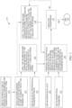
- FIG. 1 illustrates an exemplary method 100 of petrophysical inversion with machine leaming-based geologic priors according to some embodiments.
- method 100 begins at block 110 where a training dataset is created.
- the training dataset may exhibit plausible geologic behavior relevant to the subsurface region of interest, including petrophysical parameters (e.g., porosity, permeability, density, resistivity, elastic wave velocities, etc.) and corresponding rock types.
- the training dataset may comprise actual field-recorded data, or interpretations thereof, in geologic model form, and/or models resulting from computer simulations of earth processes.
- the training dataset may comprise multiple petrophysical parameters.
- the training dataset may include a tabular listing of petrophysical parameters and potentially corresponding rock types.
- the training dataset may include a listing of petrophysical parameters and probability-weighted listings of pluralities of potentially corresponding rock types.
- the training dataset may include charts, graphs, and/or other data structures relating petrophysical parameters to potentially corresponding rock types.
- the training dataset may include representations of subsurface regions (e.g., models and/or images) with identified rock types (e.g., labels). In some embodiments, a combination of any two or more of these types of datasets may be included in the training dataset.
- the training datasets may be generated from existing datasets (e.g., representations of known subsurface regions). For example, existing subsurface data may be manually and/or automatically labeled to identify petrophysical parameters and corresponding rock types. In some embodiments, the training datasets may be generated by simulation to synthesize subsurface data, including petrophysical parameters and corresponding rock types. In some embodiments, a combination of any two or more of these methods may be utilized to generate the training dataset.
- existing datasets e.g., representations of known subsurface regions.
- existing subsurface data may be manually and/or automatically labeled to identify petrophysical parameters and corresponding rock types.
- the training datasets may be generated by simulation to synthesize subsurface data, including petrophysical parameters and corresponding rock types. In some embodiments, a combination of any two or more of these methods may be utilized to generate the training dataset.
- a robust training dataset may be characterized as including representations (e.g., 1-D pseudo wells, 3-D models created by process stratigraphy, etc.) of subsurface regions (actual or simulated) at a one or more scales (e.g., grid spacing of 0.5 m, 1 m, and 1.5 m) and/or frequency regions (e.g., for seismic data with a maximum frequency of about 60 Hz, selected frequency regions may include 60 Hz, 70 Hz, 80 Hz, 90 Hz, and 100 Hz). For example, four or five frequency ranges may be utilized. In some embodiments, one or more sets of frequencies and/or mixtures thereof may be utilized (e.g., broadband).
- one or more frequencies may be selected (e.g., randomly) for each trace from a large number of frequencies in a pre-defined range.
- the training dataset may be generated by creating synthetic 1-D, 2-D, or 3-D volumes of petrophysical parameters (at the same sampling scale as will be used with the inversion) and rock types (at various scales), and by filtering the petrophysical parameters at various frequencies to get a multitude of subsets, each with the multitude of rock types at various scales.
- the final training set may consist of sets of petrophysical parameters at various frequencies and various scales of rock types.
- the training dataset created at block 110 may include large volumes of data suitable for use with a deep learning algorithm. Suitable deep learning systems and methods are further described in co-pending U.S. Provisional Patent Application Ser. No. 62/731,182, entitled “Reservoir Characterization Utilizing Resampled Seismic Data,” filed Sept. 14, 2018 .
- the learning process may utilize a large-volume training dataset to fit numerous parameters. It should be appreciated that large volumes of data having appropriate petrophysical parameter and/or rock property information may be rare in typical oil and gas operations.
- an appropriate training dataset may include thousands of well logs, each having various rock type labels, as provided by one or more experienced geoscientists. It should be appreciated that such well data is sparse in typical offshore projects.
- the training dataset may include many (e.g., thousands) of synthetic well logs.
- the synthetic well logs may be generated using an existing forward model, resulting in geologically-plausible data.
- pre-defined distributions of rock properties for different rock types and/or a single-order transition matrix (meant to mimic geologic stacking patterns) may be utilized as input to generate the synthetic well logs.
- the synthetic data may include various datasets having different frequency content (seismic and sub-seismic) and also different samplings (well log and geologic model scale) of rock types.
- Methods according to some embodiments may complete after the training dataset is created at block 110.
- one or more training datasets may be created, cataloged, stored, selected, and/or disseminated for future use with machine learning systems and/or subsurface data.
- Methods according to other embodiments may continue, e.g., as is the case for method 100 illustrated in FIG. 1 . It should also be noted that methods according to yet further embodiments may omit creation of training datasets 110 (e.g., where such datasets are already available). As illustrated in FIG. 1 , however, method 100 continues at block 120 where a machine leaming network (e.g., a convolutional neural network, or more in particular a DNN, or other suitable machine learning network) is trained with a training dataset (e.g., the created training dataset of block 110) to predict rock type probabilities.
- a machine leaming network e.g., a convolutional neural network, or more in particular a DNN, or other suitable machine learning network
- a training dataset e.g., the created training dataset of block 110
- the machine learning network may predict models, such as 1-D trace data, 2-D inline or crossline data, 3-D data cubes, and/or any petrophysical parameter models useful for building geologic priors.
- training of the machine learning network may be determined by a large number of weights.
- weights generally refer both to multiplicative variables (commonly known as weights) and/or to additive variables (commonly known as biases).
- the machine learning network may leam a preferred and/or improved setting for the large number of weights through training.
- Methods according to some embodiments may complete after the machine learning network is trained at block 120.
- one or more machine learning networks may be trained, cataloged, stored, selected, and/or disseminated for future use with machine learning systems and/or subsurface data.
- an initial petrophysical parameter estimate is obtained (note that, methods according to yet further embodiments may begin at block 130, e.g., where a trained machine learning network is already available for use).
- Obtaining an initial petrophysical parameter estimate (130) may include, for example, generating the initial petrophysical parameter estimate as a model of porosity and/or V clay .
- the initial petrophysical parameter estimate may be built from a prior seismic interpretation or inversion or modeled on one or more horizons.
- the initial petrophysical parameter estimate may be as simple as a half space model with a fixed porosity and a fixed V clay for all parameters.
- the initial petrophysical parameter estimate may be obtained from a pre-existing library of models.
- Method 100 continues at block 140 where the trained machine learning network (e.g., from block 120) is used with the initial petrophysical parameter estimate (from block 130) to predict a geologic prior model.
- the trained machine learning network may predict and/or classify rock type probabilities in conjunction with predicting geologic priors at block 140.
- Method 100 continues with obtaining input information for the inversion.
- geophysical data e.g., seismic data
- the geophysical data may include data representative of a subsurface volume (e.g., images) and corresponding identifications of geologic features for the subsurface volume (e.g., labels).
- geophysical parameters e.g., elastic parameters
- elastic parameters e.g., velocity model, resistivity model, etc.
- FWI Full Wavefield Inversion
- methods according to some embodiments may include obtaining geophysical data (represented by block 150) and/or data derived therefrom (wherein the geophysical parameters represented in block 155 are an example of such data derived therefrom).
- a seismic survey may be conducted to acquire the input information for the inversion (noting that these and other embodiments may also or instead include obtaining other geophysical data in addition to or, or instead of, seismic data-such as obtaining, electromagnetic, electrical resistivity, gravity measurements).
- simulation models may be utilized to generate synthetic input information for the inversion (e.g., computer simulation).
- the input information for the inversion may be obtained from a library of data from previous seismic surveys or previous computer simulations.
- obtaining input information for the inversion includes processing acquired data and/or simulated data (e.g., generating images, identifying and/or labeling features, manually and/or automatically annotating data elements).
- a combination of any two or more of these methods may be utilized to generate the input information for the inversion.
- Method 100 continues at block 160 where a petrophysical inversion is performed to generate a rock type probability model and an updated petrophysical parameter estimate.
- the petrophysical inversion may be based on the geologic prior model (e.g., the geologic prior model from block 140, or the geologic prior model from block 145 as further discussed below), the geophysical data from block 150, and the geophysical parameters from block 155.
- a decoder i.e., the generative function
- a machine learning network e.g., from block 120
- the updated petrophysical parameter estimate may be applicable to multiple scales, such as seismic scales, sub-seismic scales, and well log scales.
- the updated petrophysical parameter estimate may include resampled data with deep learning to be applicable to multiple scales. Suitable data resampling systems and methods are further described in the aforementioned co-pending U.S. Provisional Patent Application Ser. No. 62/731,182, entitled “Reservoir Characterization Utilizing Resampled Seismic Data,” filed Sept. 14, 2018 .
- the petrophysical inversion may seek a subsurface model which is consistent with one or more geophysical data types (e.g., seismic, electromagnetic, gravity, petrophysical well-log data, etc.).
- the decoder may replace high-dimensional variables of an output space which describe the subsurface with lower-dimensional variables in a latent space.
- the petrophysical inversion may minimize, or at least reduce, the objective function to find a preferred low-dimensional description of the subsurface. For example, during minimization and/or reduction of the objective function, a Jacobian of the decoder may be calculated with respect to the latent-space parameters, as means to determine a data-misfit-reducing search direction in latent space.
- a preferred low-dimensional description of the subsurface may be converted into high-dimensions using the decoder.
- uncertainty in the subsurface model is assessed by running multiple inversions with different decoders extracted from machine learning networks (from block 120) trained with different training sets (from block 110), thereby incorporating different geologic assumptions, processes, or environments.
- uncertainty in the subsurface model is assessed by running multiple inversions with different objective functions which reduce or minimize data misfit as well as minimizing/maximizing the values of any of the low-dimensional parameters or combinations thereof.
- Method 100 continues at block 170 where the result of the petrophysical inversion of block 160 is checked for convergence.
- the method 100 continues to iteratively update petrophysical parameter estimates and geologic prior models in order to iteratively perform petrophysical inversions. Convergence may be identified when the results of successive petrophysical inversions are appreciably similar, and/or when the estimated error therein is below a specified threshold. Once convergence has been identified, method 100 ends at block 180.
- method 100 may also end at block 180 once a specified number of iterations have occurred, and/or once an error state has been on the geologic prior model of the final iteration.
- the final rock type probabilities model may be used for geologic model building, geologic interpretation, seismic imaging, reservoir identification, operational planning, and/or other hydrocarbon management activities.
- method 100 iteratively continues at block 145 where the trained machine learning network (e.g., from block 120) is used with the updated petrophysical parameter estimate (from block 160 of the prior iteration) to predict an updated rock type probabilities model and/or a geologic prior model (noting that, as illustrated in FIG. 1 , the method 100 includes predicting both the updated rock type probabilities model and the geologic prior model).
- the iteration continues anew at block 160 where another petrophysical inversion is performed.
- the petrophysical inversion may be based on the geologic prior model from block 145, the geophysical data from block 150, and the geophysical parameters from block 155.
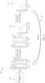
- FIG. 2 illustrates an exemplary schematic 200 of petrophysical inversion with machine learning-based geologic priors.
- a machine learning network has been trained to predict rock type probabilities according to blocks 110 and 120 of FIG. 1 .
- the schematic 200 illustrates using an initial petrophysical parameter estimate 230 (as from block 130 of FIG. 1 ) to predict a geologic prior model 240 according to block 140 of FIG. 1 .
- the schematic 200 illustrates geophysical data 250 (as from block 150 of FIG. 1 ) being used together with the initial petrophysical parameter estimate 230 and geologic prior model 240 to perform a petrophysical inversion (e.g., an optimization) to generate an updated parameter estimate 260, according to block 160 of FIG. 1 .
- a petrophysical inversion e.g., an optimization
- Schematic 200 also illustrates use of the trained machine learning network to infer rock type probabilities 265 based on the updated parameter estimate 260, according to block 160 of FIG. 1 .
- Schematic 200 also illustrates use of the trained machine learning network to update the rock type probabilities 265 from the inversion to generate updated rock type probabilities 245, according to block 145 of FIG. 1 .
- schematic 200 illustrates iteration 270 of method 100 of FIG. 1 . Note that iteration 270 is illustrated in FIG. 2 following the learning and preceding the optimization. A variation of schematic 200 could equally represent iteration 270 following the optimization and preceding the learning.
- the machine learning network may include a DNN.
- the DNN may in certain embodiments be, for example, a recurrent neural network (RNN), a convolutional neural network (CNN), and/or a generative adversarial network (GAN).
- RNN recurrent neural network
- CNN convolutional neural network
- GAN generative adversarial network
- FIG. 3A illustrates an exemplary CNN 300 that would be suitable as the machine learning network of block 120.
- CNN 300 is generally an encoder-decoder machine learning construct with an hour-glass shape.
- CNN 300 may be used to characterize a low-dimensional form of patterns found in a library of geologic examples.
- input space 310 may contain a library of geologic examples.
- the input space 310 may generally contain the training set for the CNN 300.
- the encoder network 320 may characterize input space 310 in terms of a low-dimensional encoded space 330.
- a decoder network 340 may be found to characterize encoded space 330 in terms of an output space 350.
- Decoder network 340 may convert low-dimensional encoded space 330 into a full-scale (high-dimensional) model in output space 350.
- output space 350 may conform to the geologic behavior exhibited in the training set contained in input space 310.
- Models in output space 350, generated by decoder network 340 of CNN 300, may be used as input to a deterministic inversion to find a geologically reasonable model, or collection of models, which are each consistent with the geophysical, petrophysical, and other observed data represented in the training set.
- the model-generative ability of the decoder network 340 may be utilized with an optimization (e.g., petrophysical inversion).
- the optimization may be able to search a low-dimensional, geology-conforming space for models which are consistent with quantifiable data (e.g., geophysical, seismic, electromagnetic, gravimetric, well-logs, core samples, etc.).
- the optimization may be a joint inversion.
- a training set for joint inversion may include models which are described by multiple voxelized rock parameters: resistivity, density, compressional- or shear-wave velocities, porosity, permeability, lithology type, etc. Covariance and/or interactions between these different categories of rock description may be ingrained in the training set examples by nature of the simulations or real-world observations which created these examples. Then the decoder may capture information about the different parameter interactions and distill the interactions into a simpler "latent space” description (e.g., encoded space 330). As the joint inversion proceeds, the expected rock parameter covariance (e.g., between resistivity and velocity) may be reproduced by the decoder. Consequently, the inversion models may conform to realistic rock-parameter covariance while simultaneously fitting the various observed data (e.g., electromagnetic and seismic records).
- CNN 300 may extract spatial patterns common among training models. In some embodiments, the CNN 300 may approximate the common spatial patterns, for example with a non-linear function. In some embodiments, the encoder network 320 may utilize such approximations to develop the latent parameters of encoded space 330. In some embodiments, the latent parameters may be much fewer in number than the parameters of input space 310. For example, the original training models may be represented as a large number of voxelized physical properties. In some embodiments, during training, the CNN 300 produces a decoder network 340. In some embodiments, the decoder network 340 may be a non-linear function, which maps the latent parameters back to the full-dimensionality of the original training models.
- FIG. 3B illustrates an exemplary RNN 400 that would be suitable as the machine learning network of block 120.
- the RNN is bi-directional and includes long/short-term memory (LSTM) units.
- RNN 400 may advantageously provide flexibility of incorporating training data sequences of variable lengths.
- the LSTM units may be developed to deal with exploding and vanishing gradient problems that can be encountered when training traditional RNNs.
- the LSTM units may also be designed to leam long-term dependencies, which may be useful for labelling rock types. For example, the LSTM units may allow the RNN to focus on more than just local features to classify the rock type.
- the RNN may be directional in nature, only utilizing information from the past.
- the illustrated embodiment utilizes complete logs, having information from both future and past. Therefore, the illustrated RNN is a bi-directional LSTM network.
- the machine learning network may have a modified cost function.
- a class imbalance problem may result when the training dataset includes many examples for some rock types, but far fewer examples of other rock types.
- the cost function of the machine learning network may be modified to highly penalize the machine learning network for making incorrect predictions on the rock types with fewer examples.
- different performance measures may be utilized to track the accuracy of the machine learning network (e.g., as part of the training of the machine learning network at block 120 of FIG. 1 ).
- performance measures may include such measures as confusion matrices, Precision, Recall, F1-score etc.
- FIGs. 4A-4F illustrate an exemplary set of confusion matrices comparing the prediction accuracy of a machine learning network trained on four rock types and 40 Hz data, and making predictions on test data containing six different frequencies (e.g., simulated frequency utilized in creating synthetic seismic data during an inversion step). Each of the matrices of FIGs. 4A - 4F is labeled with its corresponding "test data" frequency.
- the frequency of training data may also be matched, as closely as feasible, to the expected frequency of input data to which the machine learning network will be applied. For example, while a machine learning network trained on 100 Hz frequency test data may give good accuracy, that same network applied to 50 Hz input data (e.g., the output of an inversion, which is at 50 Hz resolution) may not work well.
- the expected rock type(s) for the subsurface region of interest may influence the performance measures. For example, the performance metrics may be weighted to emphasize one or more particular frequency bands and/or one or more particular rock types based on the expected rock type(s) for the subsurface region of interest.
- a more robust machine learning network e.g., one capable of handling a variety of frequencies for its inputs
- training the machine learning network using training data with a plurality of different frequencies (with one example being the training using seismic scale and sub-seismic scale frequencies, discussed in more detail below).
- the machine learning network of block 120 may be selected from several different machine learning networks, including CNNs, RNNs, and GANs. In some embodiments, the machine learning networks may be selected based on prediction performance (e.g., Precision, Recall, F1-score, etc.) on a validation dataset and/or on a test dataset. In some embodiments, the machine learning networks may be automatically selected (e.g., based on meeting pre-set or otherwise predetermined performance prediction indicators).
- prediction performance e.g., Precision, Recall, F1-score, etc.
- a trained machine learning system infers rock properties from petrophysical parameters.
- the machine learning system is trained with supervised learning.
- predicting rock properties (e.g., rock type) from petrophysical parameters e.g., porosity, V clay
- the input may include petrophysical parameters at both high frequency (e.g., sub-seismic scale) and low frequency (e.g., seismic scale).
- the machine learning system is trained to infer rock type at sub-seismic scales even for seismic-scale input.
- the machine learning system may be trained with supervised learning and a low-pass filter to infer sub-seismic scale rock properties from seismic-scale petrophysical parameters.
- desired high-frequency scales relate to geologic features of interest and are typically finer scales not resolved by conventional seismic data (hence they are called "sub-seismic scales").
- Scales resolved or not resolved by seismic data vary depending on a host of factors, such as acquisition method, depth, etc. As an example per some embodiments, one could have frequencies of 50 Hz in seismic data (seismic scale), and desired scales with relevant geologic features are at 100 Hz (sub-seismic scale).
- 50 Hz input low resolution, seismic scales
- 100 Hz output high resolution, subseismic scales
- the desired scales with relevant geologic features may in such cases still be even higher - such as greater than 60, 70, 80, 90, 100, 110, 120, 130, or even 140 Hz. In sum for such embodiments, then, the desired sub-seismic scales have frequency greater than the seismic scales of input data.
- a training set may include only elements that are each geologically plausible.
- the training set may include only a subspace of all possible models.
- the geologically plausible elements generally follow the same rules (e.g., patterns of layering: sequence, continuity, faulting; and ductile buoyancy flow: salt bodies) as seen in the training set.
- the training set may be a spanning representation of how plausible geology works and/or how rocks are actually arranged.
- the training set may be specific to a certain region of the earth.
- the training set may generally include plausible geology for any region of the full earth.
- the training set may exemplify in at least one example each of the pertinent geologic rules. Thus, plausibility may be defined by the statistics of the training set.
- training set elements may be created from synthetic geologic models.
- a computer simulation may be run to create some or all of the elements in the training set.
- the training set examples may be generated with process stratigraphy (PS).
- PS is a method for simulating geologic patterns.
- PS may include a numerical simulation of the physics governing how grains of rock are transported, eroded, and/or deposited in a fluid (e.g., a simulation of sediment-laden water flowing from the outlet of a river, into an ocean, and out to the down-dip extent of a delta lobe).
- a synthetic earth generator e.g., a PS simulator
- Additional examples of computer simulations of geologic patterns may include salt body plastic flow simulations, geomechanical simulations, and/or basin and petroleum system simulations. Each training model may thus represent an instance of plausible geologic behavior in the subsurface region of interest.
- training set elements may be created from heuristic methods for producing geologic models (e.g., earth modeling with functional forms, interpreted seismic sections, and/or digitized observations of rock outcrops).
- geologic models e.g., earth modeling with functional forms, interpreted seismic sections, and/or digitized observations of rock outcrops.
- the training set elements may represent geologic parameters (e.g., three-dimensional stacking patterns of rock layers) on a scale similar to that of the desired geologic model.
- geologic parameters e.g., three-dimensional stacking patterns of rock layers
- rock layers within these models may be described by such parameters as facies type (e.g., sand, shale, or salt) and/or grain-size distributions.
- facies type e.g., sand, shale, or salt
- grain-size distributions e.g., grain-size distributions.
- the rock layers of the training set elements may adhere to depositional, erosional, tectonic physics, and/or the constraints of a specific basin (e.g., observed base morphology and historical sediment flux).
- a training set may be selected to include only elements that are each geologically plausible.
- CNN 300 may be trained with such a training set.
- the encoder network 320 may take any model in input space 310 and convert this model to a latent encoded space 330.
- geologic plausibility may be measured in latent encoded space 330 by some metric (e.g., by distance from some paragon or mean latent-space model, Z ).
- the decoder network 340 may take any geologically plausible description in latent encoded space 330 and convert this description to an output space 350, which conforms to a description usable by a physics simulator (e.g., voxelized parameters).
- latent encoded space 330, output space 350, and decoder network 340 may then be utilized with a deterministic inversion method.
- the inversion may perform a parameter search in latent space.
- the inversion may use the decoder network (and its functional derivatives) to convert proposed models to the output space.
- the physical consistency of the converted proposed models may be measured with observed and/or synthetic data.
- the synthetic data may be created by physics simulation using the output space.
- the inversion may produce models which reproduce physical responses that lie within acceptable proximity to those observed (e.g., subspace 362). Since the training set included only subspace 361, the inversion may thus produce geologically-plausible models within subspace 361 which are consistent with the observed data (e.g., subspace 362). In other words, such inversion may produce those models of subspace 363.
- the present technological advancement must be used in conjunction with a geophysical data analysis system (e.g., a high-speed computer) programmed in accordance with the disclosures herein.
- a geophysical data analysis system e.g., a high-speed computer
- any of the petrophysical or other inversion techniques will in various of these embodiments be carried out using such a system.
- generating the various models e.g., geologic prior models, rock type probability models
- generating petrophysical or other parameter estimates will be carried out using such a system.
- training and applying a machine learning network will be carried out using such a system.
- Such a geophysical data analysis system may be referred to in generic shorthand simply as a "computer.”
- the same or a different computer and/or geophysical data analysis system may be used to carry out different inversions, and/or different steps of generating models, and/or different generation, training, or application of machine learning networks.
- referring to any of these steps as carried out "using a computer” will be understood to mean that the same or different computers may be used for such steps, unless context clearly dictates otherwise.
- a geophysical data analysis system employed for any of the aforementioned processes is a high performance computer (HPC), as known to those skilled in the art.
- HPC high performance computer
- Such high performance computers typically involve clusters of nodes, each node having multiple CPUs and/or graphics processing unit (GPU) clusters, and computer memory, with configuration that allows parallel (and particularly massively parallel) computation.
- the various models may be visualized and edited using any interactive visualization programs and associated hardware, such as monitors and projectors.
- the architecture of the system may vary and may be composed of any number of suitable hardware structures capable of executing logical operations and displaying the output according to the present technological advancement.
- suitable supercomputers available from Cray or IBM, as well as other architectures such as HPCs with multiple GPU clusters.
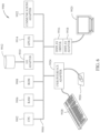
- FIG. 6 illustrates a block diagram of a geophysical data analysis system 9900.
- a central processing unit (CPU) 9902 is coupled to system bus 9904.
- the CPU 9902 may be any general-purpose CPU, although other types of architectures of CPU 9902 (or other components of exemplary system 9900) may be used as long as CPU 9902 (and other components of system 9900) supports the operations as described herein.
- Those of ordinary skill in the art will appreciate that, while only a single CPU 9902 is shown in FIG. 6 , additional CPUs may be present.
- the system 9900 may comprise a networked, multi-processor computer system that may include a hybrid parallel CPU/GPU system.
- the CPU 9902 may execute the various logical instructions according to various teachings disclosed herein. For example, the CPU 9902 may execute machine-level instructions for performing processing according to the operational flow described.
- the geophysical data analysis system 9900 may also include computer components such as non-transitory, computer-readable media. Examples of computer-readable media include a random access memory (RAM) 9906, which may be SRAM, DRAM, SDRAM, or the like.
- RAM random access memory
- the system 9900 may also include additional non-transitory, computer-readable media such as a read-only memory (ROM) 9908, which may be PROM, EPROM, EEPROM, or the like.
- ROM 9908 read-only memory
- RAM 9906 and ROM 9908 hold user and system data and programs, as is known in the art.
- the system 9900 may also include an input/output (I/O) adapter 9910, a communications adapter 9922, a user interface adapter 9924, and a display adapter 9918; the system 9900 may potentially also include one or more graphics processor units (GPUs) 9914, and one or more display driver(s) 9916.
- I/O input/output
- GPUs graphics processor units
- the I/O adapter 9910 may connect additional non-transitory, computer-readable media such as a storage device(s) 9912, including, for example, a hard drive, a compact disc (CD) drive, a floppy disk drive, a tape drive, and the like to geophysical data analysis system 9900.
- a storage device(s) 9912 including, for example, a hard drive, a compact disc (CD) drive, a floppy disk drive, a tape drive, and the like to geophysical data analysis system 9900.
- the storage device(s) may be used when RAM 9906 is insufficient for the memory requirements associated with storing data for operations of the present techniques.
- the data storage of the system 9900 may be used for storing information and/or other data used or generated as disclosed herein.
- storage device(s) 9912 may be used to store configuration information or additional plug-ins in accordance with the present techniques.
- user interface adapter 9924 couples user input devices, such as a keyboard 9928, a pointing device 9926 and/or output devices to the system 9900.
- the display adapter 9918 is driven by the CPU 9902 to control the display on a display device 9920 to, for example, present information to the user.
- the display device may be configured to display visual or graphical representations of any or all of the models discussed herein, and/or to display visual or graphical representations of a subsurface region (e.g., based at least in part upon any one or more of the models or parameters described and/or generated herein).
- the architecture of geophysical data analysis system 9900 may be varied as desired.
- any suitable processor-based device may be used, including without limitation personal computers, laptop computers, computer workstations, and multi-processor servers.
- the present technological advancement may be implemented on application specific integrated circuits (ASICs) or very large scale integrated (VLSI) circuits.
- ASICs application specific integrated circuits
- VLSI very large scale integrated circuits
- persons of ordinary skill in the art may use any number of suitable hardware structures capable of executing logical operations according to the present technological advancement.
- the term "processing circuit” encompasses a hardware processor (such as those found in the hardware devices noted above), ASICs, and VLSI circuits.
- Input data to the system 9900 may include various plug-ins and library files. Input data may additionally include configuration information.
- Geophysical data analysis system 9900 may include one or more machine learning architectures, such as autoencoders and convolutional neural networks (or any other suitable network such as those discussed and referenced herein).
- the machine learning architectures may be trained on various training datasets in accordance with the description herein.
- the machine learning architectures may be applied to analysis and/or problem solving related to various unanalyzed datasets. It should be appreciated that the machine learning architectures perform training and/or analysis that exceed human capabilities and mental processes.
- the machine learning architectures in many instances, function outside of any preprogrammed routines (e.g., varying functioning dependent upon dynamic factors, such as data input time, data processing time, dataset input or processing order, and/or a random number seed).
- the training and/or analysis performed by machine learning architectures is not performed by predefined computer algorithms and extends well beyond mental processes and abstract ideas.
- the above-described techniques, and/or systems implementing such techniques can further include hydrocarbon management based at least in part upon the above techniques.
- methods according to various embodiments may include managing hydrocarbons based at least in part upon models of subsurface regions and/or uncertainty therein constructed according to the above-described methods.
- such methods may include drilling a well, and/or causing a well to be drilled, based at least in part upon the models of subsurface regions and/or uncertainty therein (e.g., such that the well is located based at least in part upon a location determined from the models of subsurface regions and/or uncertainty therein, which location may optionally be informed by other inputs, data, and/or analyses, as well) and further prospecting for and/or producing hydrocarbons using the well.
- the models of subsurface regions and/or uncertainty therein e.g., such that the well is located based at least in part upon a location determined from the models of subsurface regions and/or uncertainty therein, which location may optionally be informed by other inputs, data, and/or analyses, as well
Landscapes
- Engineering & Computer Science (AREA)
- Physics & Mathematics (AREA)
- Life Sciences & Earth Sciences (AREA)
- General Physics & Mathematics (AREA)
- Theoretical Computer Science (AREA)
- General Life Sciences & Earth Sciences (AREA)
- Evolutionary Computation (AREA)
- Remote Sensing (AREA)
- Geophysics (AREA)
- General Engineering & Computer Science (AREA)
- Artificial Intelligence (AREA)
- Software Systems (AREA)
- Data Mining & Analysis (AREA)
- Health & Medical Sciences (AREA)
- Molecular Biology (AREA)
- Mathematical Physics (AREA)
- General Health & Medical Sciences (AREA)
- Computational Linguistics (AREA)
- Biophysics (AREA)
- Biomedical Technology (AREA)
- Computing Systems (AREA)
- Geology (AREA)
- Environmental & Geological Engineering (AREA)
- Acoustics & Sound (AREA)
- Mining & Mineral Resources (AREA)
- Fluid Mechanics (AREA)
- Geochemistry & Mineralogy (AREA)
- Computer Vision & Pattern Recognition (AREA)
- Medical Informatics (AREA)
- Computer Hardware Design (AREA)
- Geometry (AREA)
- Geophysics And Detection Of Objects (AREA)
Claims (13)
- Verfahren zum Modellieren einer Untergrundregion, bei dem:ein trainiertes Maschinenlernen-Netzwerk bereitgestellt wird, wobei das Bereitstellen des trainierten Maschinenlernen-Netzwerks beinhaltet, das Maschinenlernen-Netzwerk mit einem Trainingsdatensatz zu trainieren (120), um auf Grundlage von petrophysikalischen Parametern Felstypwahrscheinlichkeiten vorherzusagen,eine anfängliche Petrophysikparameter-Schätzung bereitgestellt wird (130),das trainierte Maschinenlernen-Netzwerk auf die anfängliche Petrophysikparameter-Schätzung angewendet wird, um ein geologisches A-Priori-Modell vorherzusagen (140),geophysikalische Daten für die Untergrundregion bereitgestellt werden, die während einer geophysikalischen Vermessung der Untergrundregion erfasst worden sind (150),geophysikalische Parameter für die Untergrundregion bereitgestellt werden (155) undmit dem geologischen A-Priori-Modell, den geophysikalischen Daten und den geophysikalischen Parametern eine petrophysikalische Inversion durchgeführt wird, um ein Felstypwahrscheinlichkeitsmodell und eine aktualisierte Petrophysikparameter-Schätzung zu erzeugen (160),wobei sowohl (i) das Anwenden des trainierten Maschinenlernen-Netzwerks als auch (ii) das Durchführen der petrophysikalischen Inversion unter Verwendung eines geophysikalischen Datenanalysesystems durchgeführt wird undwobei das Maschinenlernen-Netzwerk trainiert ist, um Felstypwahrscheinlichkeiten auf subseismischer Skala für Eingangswerte mit petrophysikalischen Parametern vorherzusagen, die aus Daten auf seismischer Skala erhalten worden sind.
- Verfahren nach Anspruch 1, wobei die geophysikalischen Daten seismische Daten umfassen und die geophysikalischen Parameter Elastizitätsparameter umfassen.
- Verfahren nach Anspruch 2, wobei die Elastizitätsparameter aus den seismischen Daten abgeleitet sind.
- Verfahren nach einem der Ansprüche 1-3, wobei die petrophysikalische Inversion eine Optimierungsprozedur beinhaltet.
- Verfahren nach einem der Ansprüche 1-4, wobei die anfängliche Petrophysikparameter-Schätzung und die aktualisierte Petrophysikparameter-Schätzung jeweils wenigstens eines von Porosität und Tonvolumen umfassen.
- Verfahren nach einem der Ansprüche 1-5, wobei der Trainingsdatensatz eine Mehrzahl von Datensätzen mit verschiedenen Frequenzinhalten und verschiedenen Abtastschrittweiten umfasst.
- Verfahren nach Anspruch 6, wobei die verschiedenen Frequenzinhalte und die verschiedenen Abtastschrittweiten der Datensätze sowohl Datensätze subseismischer Skala als auch Datensätze seismischer Skala umfassen, wobei die Frequenz der Datensätze subseismischer Skala höher als die Frequenz der Datensätze seismischer Skala ist.
- Verfahren nach einem der Ansprüche 1-7, bei dem weiterhin der Trainingsdatensatz erzeugt wird, indem unter Verwendung eines vorhandenen Vorwärtsmodells synthetische Bohrlochprotokolle erzeugt werden.
- Verfahren nach einem der Ansprüche 1-8, wobei der Trainingsdatensatz wenigstens 1000 Bohrlochprotokolle umfasst.
- Verfahren nach einem der Ansprüche 1-9, bei dem weiter:nach Durchführung der petrophysikalischen Inversion die Konvergenz der aktualisierten Petrophysikparameter-Schätzung geprüft wird undwenn das Ergebnis der Prüfung auf Konvergenz negativ ist, in iterativer Weisedas trainierte Maschinenlernen-Netzwerk auf die aktualisierte Petrophysikparameter-Schätzung einer vorhergehenden Iteration angewendet wird, um ein aktualisiertes Felstypwahrscheinlichkeitsmodell und ein anderes geologisches A-Priori-Modell vorherzusagen,eine petrophysikalische Inversion mit dem anderen geologischen A-Priori-Modell, geophysikalischen Daten und geophysikalischen Parametern durchgeführt wird, um ein anderes Felsentypwahrscheinlichkeitsmodell und eine andere aktualisierte Petrophysikparameter-Schätzung zu erzeugen, unddie Konvergenz der anderen aktualisierten Petrophysikparameter-Schätzung geprüft wird.
- Verfahren nach einem der Ansprüche 1-10, wobei das Maschinenlernen-Netzwerk wenigstens eines von einem tiefen neuronalen Netzwerk, einem rekurrenten neuronalen Netzwerk, einem neuronalen Faltungsnetzwerk und einem generativen adversarialen Netzwerk aufweist.
- Verfahren nach einem der Ansprüche 1-11, bei dem weiterhin Kohlenwasserstoffe wenigstens teilweise basierend auf dem Felstypwahrscheinlichkeitsmodell gehandhabt werden.
- Verfahren nach einem der Ansprüche 1-12, wobei das geophysikalische Datenanalysesystem aufweist:einen Prozessor undeine Anzeige, die dazu eingerichtet ist, graphische Repräsentationen eines geophysikalischen Datensatzes anzuzeigen, wobei der Prozessor dazu eingerichtet ist,das trainierte Maschinenlernen-Netzwerk auf die anfängliche Petrophysikparameter-Schätzung anzuwenden, um das geologische A-Priori-Modell vorherzusagen, unddie petrophysikalische Inversion mit dem geologischen A-Priori-Modell, den geophysikalischen Daten einer Untergrundregion und den geophysikalischen Parametern der Untergrundregion durchzuführen, um ein Felsentypwahrscheinlichkeitsmodell und die aktualisierte Petrophysikparameter-Schätzung zu erzeugen.
Applications Claiming Priority (2)
| Application Number | Priority Date | Filing Date | Title |
|---|---|---|---|
| US201962883348P | 2019-08-06 | 2019-08-06 | |
| PCT/US2020/070030 WO2021026545A1 (en) | 2019-08-06 | 2020-05-06 | Petrophysical inversion with machine learning-based geologic priors |
Publications (2)
| Publication Number | Publication Date |
|---|---|
| EP4010740A1 EP4010740A1 (de) | 2022-06-15 |
| EP4010740B1 true EP4010740B1 (de) | 2025-02-19 |
Family
ID=70922174
Family Applications (1)
| Application Number | Title | Priority Date | Filing Date |
|---|---|---|---|
| EP20729927.2A Active EP4010740B1 (de) | 2019-08-06 | 2020-05-06 | Petrophysikalische inversion mit auf maschinenlernen basierten geologischen prioren |
Country Status (4)
| Country | Link |
|---|---|
| US (1) | US11668853B2 (de) |
| EP (1) | EP4010740B1 (de) |
| AU (1) | AU2020325168B2 (de) |
| WO (1) | WO2021026545A1 (de) |
Families Citing this family (72)
| Publication number | Priority date | Publication date | Assignee | Title |
|---|---|---|---|---|
| US11719048B2 (en) * | 2019-10-01 | 2023-08-08 | Schlumberger Technology Corporation | Geo-steering using electromagnetic gap impedance data |
| US11913865B2 (en) * | 2020-01-08 | 2024-02-27 | Khalifa University of Science and Technology | In-situ prediction and dynamic visualization of relative permeability and capillary pressure in porous medium |
| US11339651B2 (en) * | 2020-02-13 | 2022-05-24 | Saudi Arabian Oil Company | Systems and methods for generating continuous grain size logs from petrographic thin section images |
| WO2021236095A1 (en) * | 2020-05-22 | 2021-11-25 | Landmark Graphics Corporation | Facilitating hydrocarbon exploration from earth system models |
| EP4162150A4 (de) * | 2020-06-08 | 2024-06-19 | Services Pétroliers Schlumberger | Fehleranalyse einer automatisierten elektrischen tauchpumpe (esp) |
| US11687804B2 (en) * | 2020-06-30 | 2023-06-27 | Fair Isaac Corporation | Latent feature dimensionality bounds for robust machine learning on high dimensional datasets |
| US11733424B2 (en) * | 2020-07-31 | 2023-08-22 | Chevron U.S.A. Inc. | Systems and methods for identifying subsurface features as functions of feature positions in a subsurface volume of interest |
| US11841479B2 (en) | 2020-07-31 | 2023-12-12 | Chevron U.S.A. Inc. | Systems and methods for identifying subsurface features as a function of position in a subsurface volume of interest |
| US11898435B2 (en) * | 2020-09-25 | 2024-02-13 | Halliburton Energy Services, Inc. | Correcting borehole images using machine-learning models |
| CN112882100B (zh) * | 2021-02-25 | 2024-01-12 | 中海石油深海开发有限公司 | 一种储层参数确定方法、装置、电子设备和存储介质 |
| US20220325613A1 (en) * | 2021-04-08 | 2022-10-13 | Saudi Arabian Oil Company | System and method for petrophysical modeling automation based on machine learning |
| WO2022236222A1 (en) | 2021-05-03 | 2022-11-10 | Exxonmobil Upstream Research Company | Machine learning for the optimization of liquefaction processes in the production of liquefied natural gas |
| CN112990460B (zh) * | 2021-05-06 | 2021-08-17 | 中国科学院自动化研究所 | 人机对抗分布式训练系统和方法 |
| CN115327643B (zh) * | 2021-05-11 | 2024-09-10 | 中国石油化工股份有限公司 | 用于油气智能检测的机器学习训练样本扩充及评价方法 |
| CN113341459B (zh) * | 2021-05-12 | 2022-04-12 | 北京大学 | 基于机器学习和动力学计算融合的地震定位方法与设备 |
| CN115407390B (zh) * | 2021-05-28 | 2025-04-29 | 中国石油天然气股份有限公司 | 地震储层参数预测方法及装置 |
| CN113283173B (zh) * | 2021-05-31 | 2023-11-24 | 沈阳工业大学 | 地下工程能量与参数综合反分析系统及其方法 |
| CN113534158B (zh) * | 2021-06-10 | 2024-06-11 | 国家卫星气象中心(国家空间天气监测预警中心) | 基于深度学习的静止轨道气象卫星雷达反射率因子反演方法 |
| US20220414522A1 (en) * | 2021-06-29 | 2022-12-29 | Landmark Graphics Corporation | Machine learning based ranking of hydrocarbon prospects for field exploration |
| US11828168B2 (en) | 2021-06-30 | 2023-11-28 | Saudi Arabian Oil Company | Method and system for correcting and predicting sonic well logs using physics-constrained machine learning |
| CN113343923B (zh) * | 2021-07-01 | 2024-12-03 | 江苏舆图信息科技有限公司 | 一种基于视频图像的河道排口排水状态实时识别方法 |
| CN114047548B (zh) * | 2021-07-07 | 2023-03-14 | 清华大学 | 一种基于闭环网络的地震波阻抗反演不确定性的预测方法 |
| CN113534263B (zh) * | 2021-07-13 | 2022-04-08 | 广州海洋地质调查局 | 一种不依赖测井资料的含油气饱和度预测方法 |
| CN113608258B (zh) * | 2021-07-16 | 2024-01-19 | 长江大学 | 一种构建高分辨率波阻抗反演标签的自洽深度学习方法 |
| CN115685314B (zh) * | 2021-07-23 | 2026-03-27 | 中国石油天然气股份有限公司 | 一种地震储层物性参数预测方法及装置 |
| US12228028B2 (en) * | 2021-08-05 | 2025-02-18 | Chevron U.S.A. Inc. | Systems and methods for generating depth uncertainty values as a function of position in a subsurface volume of interest |
| CN113740903B (zh) * | 2021-08-27 | 2022-12-09 | 西安交通大学 | 数据与智能优化双驱动的深度学习地震波阻抗反演方法 |
| CN113722412B (zh) * | 2021-09-01 | 2023-09-08 | 天津大学 | 一种于空间维度上查询及预测岩石参数的方法 |
| CN113919480B (zh) * | 2021-09-07 | 2025-11-21 | 河海大学 | 基于条件式生成对抗网络的弹性参数高频成分恢复方法 |
| CN115808718B (zh) * | 2021-09-13 | 2025-11-18 | 中国石油化工股份有限公司 | 一种基于测井数据的流体相预测方法与设备 |
| CN113687433B (zh) * | 2021-09-15 | 2022-07-12 | 湖南师范大学 | 一种基于Bi-LSTM的大地电磁信号去噪方法及系统 |
| CN113609790B (zh) * | 2021-10-11 | 2021-12-03 | 成都数联云算科技有限公司 | 产品虚拟量测方法及系统及装置及介质 |
| CN116047583B (zh) * | 2021-10-27 | 2026-03-17 | 中国石油化工股份有限公司 | 基于深度卷积神经网络的自适应波阻抗反演方法及系统 |
| EP4177644B1 (de) * | 2021-11-05 | 2025-01-01 | MATRIX JVCO LTD trading as AIQ | Verfahren und system zur bestimmung von geomechanischen parametern eines bohrlochs |
| CN114117906B (zh) * | 2021-11-19 | 2024-05-10 | 山东大学 | 基于观测数据自编码的多尺度无监督地震波速反演方法 |
| CN113868967B (zh) * | 2021-12-03 | 2022-04-12 | 中铁第一勘察设计院集团有限公司 | 结构监测数据预测方法、装置及存储介质 |
| CN114254566B (zh) * | 2021-12-27 | 2024-06-04 | 厦门大学 | 一种基于2.5维混合谱元法的神经网络地质探测反演方法 |
| CN114355447B (zh) * | 2022-01-13 | 2022-09-02 | 中国安能集团第三工程局有限公司 | 一种隧道工程围岩等级快速划分方法及装置 |
| CN114492521A (zh) * | 2022-01-21 | 2022-05-13 | 成都理工大学 | 一种基于声振信号的随钻岩性智能识别方法与系统 |
| CN114563823B (zh) * | 2022-03-25 | 2024-10-18 | 清华大学 | 一种储层岩性和物性参数的联合贝叶斯反演方法和系统 |
| CN114740529B (zh) * | 2022-04-08 | 2024-08-13 | 北京大学深圳研究院 | 一种主动源震电频谱比值反演孔隙介质渗透系数的方法 |
| CN114861563B (zh) * | 2022-04-27 | 2022-12-13 | 中国石油大学(华东) | 物理嵌入深度学习地层压力预测方法、装置、介质及设备 |
| CN114676644B (zh) | 2022-05-27 | 2022-08-23 | 成都理工大学 | 一种基于机器学习约束的密度突变界面反演方法及系统 |
| CN115166822A (zh) * | 2022-08-02 | 2022-10-11 | 中国矿业大学(北京) | 储层弹性参数的预测方法、装置和电子设备 |
| CN115203970B (zh) * | 2022-08-03 | 2023-04-07 | 中国石油大学(北京) | 基于人工智能算法的成岩参数预测模型训练方法和预测方法 |
| CN115577612B (zh) * | 2022-08-04 | 2025-06-06 | 山东大学 | 基于深度学习的隧道电阻率极化率联合反演梯度优化方法 |
| CN115937568B (zh) * | 2022-09-29 | 2024-05-07 | 中国地质大学(北京) | 一种玄武岩构造背景分类方法、系统、装置及存储介质 |
| CN115508206B (zh) * | 2022-10-11 | 2024-07-05 | 昆明理工大学 | 一种节理岩质边坡岩体强度参数概率反演方法 |
| CN115630573B (zh) * | 2022-10-18 | 2026-04-03 | 吉林大学 | 基于maddpg的大地电磁数据反演方法 |
| CN115641008B (zh) * | 2022-10-31 | 2024-07-12 | 山东科技大学 | 一种基于人工智能的碳酸盐岩溶蚀速率自动监测系统 |
| CN115713035A (zh) * | 2022-11-23 | 2023-02-24 | 东南大学 | 一种基于双向循环神经网络的海洋工程岩体评分方法 |
| CN115936990B (zh) * | 2022-12-07 | 2023-11-17 | 中国科学技术大学 | 地震资料多尺度超分辨率与去噪同步处理方法及系统 |
| CN115903026B (zh) * | 2023-01-09 | 2023-05-09 | 东北石油大学三亚海洋油气研究院 | 复合砂体构型解析方法、设备及介质 |
| CN116090352A (zh) * | 2023-02-01 | 2023-05-09 | 北京华电力拓能源科技有限公司 | 一种基于门循环单元和注意力机制的全波形反演方法 |
| US20240273232A1 (en) * | 2023-02-15 | 2024-08-15 | BeeKeeperAI, Inc. | Systems and methods for measuring data exfiltration vulnerability and dynamic differential privacy in a zero-trust computing environment |
| CN115877478B (zh) * | 2023-02-24 | 2023-05-12 | 山东全波石油技术开发有限公司 | 一种基于DualGAN的地震资料高分辨率处理方法 |
| CN116467784A (zh) * | 2023-04-26 | 2023-07-21 | 中建八局发展建设有限公司 | 一种桁架支撑加固方法 |
| US20240394529A1 (en) * | 2023-05-26 | 2024-11-28 | Halliburton Energy Services, Inc. | Generative machine learning based petrophysics interpretation |
| CN117166996B (zh) * | 2023-07-27 | 2024-03-22 | 中国地质大学(北京) | 地质参数门槛值的确定方法、装置、设备及存储介质 |
| CN117332240B (zh) * | 2023-12-01 | 2024-04-16 | 中铁四局集团有限公司 | 岩爆预测模型构建方法、存储介质、岩爆预测方法及系统 |
| CN118484709B (zh) * | 2024-04-19 | 2025-07-11 | 云南省交通规划设计研究院股份有限公司 | 一种基于动态数值模拟的随钻测试岩石快速识别方法 |
| CN118295016B (zh) * | 2024-05-07 | 2024-09-03 | 西南交通大学 | 一种多元参数耦合数据-知识双驱动地震反演方法 |
| CN118277887B (zh) * | 2024-05-31 | 2025-02-11 | 深圳大学 | 基于机器学习的水泥基材料性能优化方法及系统 |
| CN118864753B (zh) * | 2024-09-26 | 2025-05-23 | 浙江省工程物探勘察设计院有限公司 | 一种基于bim的地质信息采集系统 |
| CN119337135B (zh) * | 2024-10-18 | 2025-05-16 | 中国自然资源航空物探遥感中心 | 一种重力数据反演方法、系统及介质 |
| CN119646465B (zh) * | 2024-11-25 | 2025-10-17 | 吉林大学 | 一种融合电阻率层析成像与水文观测数据的非均质含水层结构智能识别方法及系统 |
| CN120145121B (zh) * | 2025-03-17 | 2025-12-05 | 成都理工大学 | 一种应用于砂体的电性特征识别方法及系统 |
| CN119962269B (zh) * | 2025-04-11 | 2025-08-12 | 中国电建集团中南勘测设计研究院有限公司 | 一种掌子面前方地质构造预报方法、设备及储存介质 |
| CN120447044B (zh) * | 2025-05-06 | 2026-04-28 | 中国矿业大学 | 一种岩石物理与深度学习双重驱动的储层物性参数智能预测方法 |
| CN120125952B (zh) * | 2025-05-13 | 2025-07-22 | 中国海洋大学 | 一种基于多尺度特征融合网络的smap高分辨率海表盐度反演方法 |
| CN120781266B (zh) * | 2025-09-10 | 2025-11-14 | 四川省第七地质大队 | 一种基于大数据分析的野外电法勘探数据异常识别方法 |
| CN121562032B (zh) * | 2026-01-20 | 2026-04-03 | 文华学院 | 开挖面失稳与邻近建构筑物变形的互馈演化方法和系统 |
Family Cites Families (8)
| Publication number | Priority date | Publication date | Assignee | Title |
|---|---|---|---|---|
| WO2010080366A1 (en) | 2009-01-09 | 2010-07-15 | Exxonmobil Upstream Research Company | Hydrocarbon detection with passive seismic data |
| US8843353B2 (en) | 2011-08-25 | 2014-09-23 | Chevron U.S.A. Inc. | Hybrid deterministic-geostatistical earth model |
| CN107783183B (zh) | 2016-08-31 | 2019-10-29 | 中国石油化工股份有限公司 | 深度域地震波阻抗反演方法及系统 |
| WO2018102043A1 (en) | 2016-12-02 | 2018-06-07 | Exxonmobil Upstream Research Company | Method for estimating petrophysical properties for single or multiple scenarios from several spectrally variable seismic and full wavefield inversion products |
| US11125899B2 (en) | 2017-08-15 | 2021-09-21 | Exxonmobil Upstream Research Company | Reservoir materiality bounds from seismic inversion |
| US10996372B2 (en) * | 2017-08-25 | 2021-05-04 | Exxonmobil Upstream Research Company | Geophysical inversion with convolutional neural networks |
| SG11202100461SA (en) | 2018-09-14 | 2021-04-29 | Exxonmobil Upstream Res Co | Reservoir characterization utilizing inversion of resampled seismic data |
| US11397272B2 (en) * | 2018-12-11 | 2022-07-26 | Exxonmobil Upstream Research Company | Data augmentation for seismic interpretation systems and methods |
-
2020
- 2020-05-06 EP EP20729927.2A patent/EP4010740B1/de active Active
- 2020-05-06 US US15/929,505 patent/US11668853B2/en active Active
- 2020-05-06 WO PCT/US2020/070030 patent/WO2021026545A1/en not_active Ceased
- 2020-05-06 AU AU2020325168A patent/AU2020325168B2/en active Active
Also Published As
| Publication number | Publication date |
|---|---|
| EP4010740A1 (de) | 2022-06-15 |
| WO2021026545A1 (en) | 2021-02-11 |
| US11668853B2 (en) | 2023-06-06 |
| CA3149677A1 (en) | 2021-02-11 |
| AU2020325168A1 (en) | 2022-03-03 |
| US20210041596A1 (en) | 2021-02-11 |
| AU2020325168B2 (en) | 2026-03-19 |
Similar Documents
| Publication | Publication Date | Title |
|---|---|---|
| EP4010740B1 (de) | Petrophysikalische inversion mit auf maschinenlernen basierten geologischen prioren | |
| US11435498B2 (en) | Subsurface models with uncertainty quantification | |
| US11520077B2 (en) | Automated reservoir modeling using deep generative networks | |
| EP3894907B1 (de) | Durch maschinelles lernen erweiterte geophysikalische inversion | |
| US11693139B2 (en) | Automated seismic interpretation-guided inversion | |
| AU2023200300B2 (en) | Detecting fluid types using petrophysical inversion | |
| CN109154674B (zh) | 利用光流确定在地震图像之间的位移 | |
| CN109073772B (zh) | 利用光流确定在地震图像之间的位移 | |
| CA3149677C (en) | Petrophysical inversion with machine learning-based geologic priors | |
| US20240052734A1 (en) | Machine learning framework for sweep efficiency quantification | |
| CA3107882C (en) | Detecting fluid types using petrophysical inversion | |
| BR112021011250B1 (pt) | Modelagem automatizada de reservatório usando redes generativas profundas |
Legal Events
| Date | Code | Title | Description |
|---|---|---|---|
| STAA | Information on the status of an ep patent application or granted ep patent |
Free format text: STATUS: UNKNOWN |
|
| STAA | Information on the status of an ep patent application or granted ep patent |
Free format text: STATUS: THE INTERNATIONAL PUBLICATION HAS BEEN MADE |
|
| PUAI | Public reference made under article 153(3) epc to a published international application that has entered the european phase |
Free format text: ORIGINAL CODE: 0009012 |
|
| STAA | Information on the status of an ep patent application or granted ep patent |
Free format text: STATUS: REQUEST FOR EXAMINATION WAS MADE |
|
| 17P | Request for examination filed |
Effective date: 20220221 |
|
| AK | Designated contracting states |
Kind code of ref document: A1 Designated state(s): AL AT BE BG CH CY CZ DE DK EE ES FI FR GB GR HR HU IE IS IT LI LT LU LV MC MK MT NL NO PL PT RO RS SE SI SK SM TR |
|
| DAV | Request for validation of the european patent (deleted) | ||
| DAX | Request for extension of the european patent (deleted) | ||
| RAP1 | Party data changed (applicant data changed or rights of an application transferred) |
Owner name: EXXONMOBIL TECHNOLOGY AND ENGINEERING COMPANY |
|
| STAA | Information on the status of an ep patent application or granted ep patent |
Free format text: STATUS: EXAMINATION IS IN PROGRESS |
|
| 17Q | First examination report despatched |
Effective date: 20240411 |
|
| GRAP | Despatch of communication of intention to grant a patent |
Free format text: ORIGINAL CODE: EPIDOSNIGR1 |
|
| STAA | Information on the status of an ep patent application or granted ep patent |
Free format text: STATUS: GRANT OF PATENT IS INTENDED |
|
| RIC1 | Information provided on ipc code assigned before grant |
Ipc: G01V 20/00 20240101ALI20240925BHEP Ipc: G01V 11/00 20060101ALI20240925BHEP Ipc: G01V 1/30 20060101ALI20240925BHEP Ipc: G01V 1/28 20060101AFI20240925BHEP |
|
| INTG | Intention to grant announced |
Effective date: 20241002 |
|
| GRAS | Grant fee paid |
Free format text: ORIGINAL CODE: EPIDOSNIGR3 |
|
| GRAA | (expected) grant |
Free format text: ORIGINAL CODE: 0009210 |
|
| STAA | Information on the status of an ep patent application or granted ep patent |
Free format text: STATUS: THE PATENT HAS BEEN GRANTED |
|
| P01 | Opt-out of the competence of the unified patent court (upc) registered |
Free format text: CASE NUMBER: APP_67125/2024 Effective date: 20241219 |
|
| AK | Designated contracting states |
Kind code of ref document: B1 Designated state(s): AL AT BE BG CH CY CZ DE DK EE ES FI FR GB GR HR HU IE IS IT LI LT LU LV MC MK MT NL NO PL PT RO RS SE SI SK SM TR |
|
| REG | Reference to a national code |
Ref country code: GB Ref legal event code: FG4D |
|
| REG | Reference to a national code |
Ref country code: CH Ref legal event code: EP |
|
| REG | Reference to a national code |
Ref country code: DE Ref legal event code: R096 Ref document number: 602020046300 Country of ref document: DE |
|
| REG | Reference to a national code |
Ref country code: IE Ref legal event code: FG4D |
|
| REG | Reference to a national code |
Ref country code: NL Ref legal event code: MP Effective date: 20250219 |
|
| PG25 | Lapsed in a contracting state [announced via postgrant information from national office to epo] |
Ref country code: RS Free format text: LAPSE BECAUSE OF FAILURE TO SUBMIT A TRANSLATION OF THE DESCRIPTION OR TO PAY THE FEE WITHIN THE PRESCRIBED TIME-LIMIT Effective date: 20250519 |
|
| PG25 | Lapsed in a contracting state [announced via postgrant information from national office to epo] |
Ref country code: FI Free format text: LAPSE BECAUSE OF FAILURE TO SUBMIT A TRANSLATION OF THE DESCRIPTION OR TO PAY THE FEE WITHIN THE PRESCRIBED TIME-LIMIT Effective date: 20250219 |
|
| PG25 | Lapsed in a contracting state [announced via postgrant information from national office to epo] |
Ref country code: PL Free format text: LAPSE BECAUSE OF FAILURE TO SUBMIT A TRANSLATION OF THE DESCRIPTION OR TO PAY THE FEE WITHIN THE PRESCRIBED TIME-LIMIT Effective date: 20250219 |
|
| PG25 | Lapsed in a contracting state [announced via postgrant information from national office to epo] |
Ref country code: ES Free format text: LAPSE BECAUSE OF FAILURE TO SUBMIT A TRANSLATION OF THE DESCRIPTION OR TO PAY THE FEE WITHIN THE PRESCRIBED TIME-LIMIT Effective date: 20250219 |
|
| PGFP | Annual fee paid to national office [announced via postgrant information from national office to epo] |
Ref country code: GB Payment date: 20250520 Year of fee payment: 6 |
|
| REG | Reference to a national code |
Ref country code: LT Ref legal event code: MG9D |
|
| PG25 | Lapsed in a contracting state [announced via postgrant information from national office to epo] |
Ref country code: IS Free format text: LAPSE BECAUSE OF FAILURE TO SUBMIT A TRANSLATION OF THE DESCRIPTION OR TO PAY THE FEE WITHIN THE PRESCRIBED TIME-LIMIT Effective date: 20250619 |
|
| PGFP | Annual fee paid to national office [announced via postgrant information from national office to epo] |
Ref country code: NO Payment date: 20250520 Year of fee payment: 6 |
|
| PG25 | Lapsed in a contracting state [announced via postgrant information from national office to epo] |
Ref country code: NL Free format text: LAPSE BECAUSE OF FAILURE TO SUBMIT A TRANSLATION OF THE DESCRIPTION OR TO PAY THE FEE WITHIN THE PRESCRIBED TIME-LIMIT Effective date: 20250219 |
|
| PG25 | Lapsed in a contracting state [announced via postgrant information from national office to epo] |
Ref country code: HR Free format text: LAPSE BECAUSE OF FAILURE TO SUBMIT A TRANSLATION OF THE DESCRIPTION OR TO PAY THE FEE WITHIN THE PRESCRIBED TIME-LIMIT Effective date: 20250219 |
|
| PG25 | Lapsed in a contracting state [announced via postgrant information from national office to epo] |
Ref country code: PT Free format text: LAPSE BECAUSE OF FAILURE TO SUBMIT A TRANSLATION OF THE DESCRIPTION OR TO PAY THE FEE WITHIN THE PRESCRIBED TIME-LIMIT Effective date: 20250620 Ref country code: LV Free format text: LAPSE BECAUSE OF FAILURE TO SUBMIT A TRANSLATION OF THE DESCRIPTION OR TO PAY THE FEE WITHIN THE PRESCRIBED TIME-LIMIT Effective date: 20250219 |
|
| PGFP | Annual fee paid to national office [announced via postgrant information from national office to epo] |
Ref country code: FR Payment date: 20250526 Year of fee payment: 6 |
|
| PG25 | Lapsed in a contracting state [announced via postgrant information from national office to epo] |
Ref country code: GR Free format text: LAPSE BECAUSE OF FAILURE TO SUBMIT A TRANSLATION OF THE DESCRIPTION OR TO PAY THE FEE WITHIN THE PRESCRIBED TIME-LIMIT Effective date: 20250520 Ref country code: BG Free format text: LAPSE BECAUSE OF FAILURE TO SUBMIT A TRANSLATION OF THE DESCRIPTION OR TO PAY THE FEE WITHIN THE PRESCRIBED TIME-LIMIT Effective date: 20250219 |
|
| REG | Reference to a national code |
Ref country code: AT Ref legal event code: MK05 Ref document number: 1768778 Country of ref document: AT Kind code of ref document: T Effective date: 20250219 |
|
| PG25 | Lapsed in a contracting state [announced via postgrant information from national office to epo] |
Ref country code: SE Free format text: LAPSE BECAUSE OF FAILURE TO SUBMIT A TRANSLATION OF THE DESCRIPTION OR TO PAY THE FEE WITHIN THE PRESCRIBED TIME-LIMIT Effective date: 20250219 |
|
| PG25 | Lapsed in a contracting state [announced via postgrant information from national office to epo] |
Ref country code: SM Free format text: LAPSE BECAUSE OF FAILURE TO SUBMIT A TRANSLATION OF THE DESCRIPTION OR TO PAY THE FEE WITHIN THE PRESCRIBED TIME-LIMIT Effective date: 20250219 |
|
| PG25 | Lapsed in a contracting state [announced via postgrant information from national office to epo] |
Ref country code: DK Free format text: LAPSE BECAUSE OF FAILURE TO SUBMIT A TRANSLATION OF THE DESCRIPTION OR TO PAY THE FEE WITHIN THE PRESCRIBED TIME-LIMIT Effective date: 20250219 |
|
| PG25 | Lapsed in a contracting state [announced via postgrant information from national office to epo] |
Ref country code: IT Free format text: LAPSE BECAUSE OF FAILURE TO SUBMIT A TRANSLATION OF THE DESCRIPTION OR TO PAY THE FEE WITHIN THE PRESCRIBED TIME-LIMIT Effective date: 20250219 |
|
| PG25 | Lapsed in a contracting state [announced via postgrant information from national office to epo] |
Ref country code: AT Free format text: LAPSE BECAUSE OF FAILURE TO SUBMIT A TRANSLATION OF THE DESCRIPTION OR TO PAY THE FEE WITHIN THE PRESCRIBED TIME-LIMIT Effective date: 20250219 |
|
| PG25 | Lapsed in a contracting state [announced via postgrant information from national office to epo] |
Ref country code: EE Free format text: LAPSE BECAUSE OF FAILURE TO SUBMIT A TRANSLATION OF THE DESCRIPTION OR TO PAY THE FEE WITHIN THE PRESCRIBED TIME-LIMIT Effective date: 20250219 Ref country code: CZ Free format text: LAPSE BECAUSE OF FAILURE TO SUBMIT A TRANSLATION OF THE DESCRIPTION OR TO PAY THE FEE WITHIN THE PRESCRIBED TIME-LIMIT Effective date: 20250219 |
|
| PG25 | Lapsed in a contracting state [announced via postgrant information from national office to epo] |
Ref country code: RO Free format text: LAPSE BECAUSE OF FAILURE TO SUBMIT A TRANSLATION OF THE DESCRIPTION OR TO PAY THE FEE WITHIN THE PRESCRIBED TIME-LIMIT Effective date: 20250219 |
|
| PG25 | Lapsed in a contracting state [announced via postgrant information from national office to epo] |
Ref country code: SK Free format text: LAPSE BECAUSE OF FAILURE TO SUBMIT A TRANSLATION OF THE DESCRIPTION OR TO PAY THE FEE WITHIN THE PRESCRIBED TIME-LIMIT Effective date: 20250219 |
|
| REG | Reference to a national code |
Ref country code: DE Ref legal event code: R097 Ref document number: 602020046300 Country of ref document: DE |
|
| REG | Reference to a national code |
Ref country code: DE Ref legal event code: R119 Ref document number: 602020046300 Country of ref document: DE |
|
| REG | Reference to a national code |
Ref country code: CH Ref legal event code: H13 Free format text: ST27 STATUS EVENT CODE: U-0-0-H10-H13 (AS PROVIDED BY THE NATIONAL OFFICE) Effective date: 20251223 |
|
| PLBE | No opposition filed within time limit |
Free format text: ORIGINAL CODE: 0009261 |
|
| STAA | Information on the status of an ep patent application or granted ep patent |
Free format text: STATUS: NO OPPOSITION FILED WITHIN TIME LIMIT |
|
| PG25 | Lapsed in a contracting state [announced via postgrant information from national office to epo] |
Ref country code: LU Free format text: LAPSE BECAUSE OF NON-PAYMENT OF DUE FEES Effective date: 20250506 |
|
| PG25 | Lapsed in a contracting state [announced via postgrant information from national office to epo] |
Ref country code: CH Free format text: LAPSE BECAUSE OF NON-PAYMENT OF DUE FEES Effective date: 20250531 |
|
| 26N | No opposition filed |
Effective date: 20251120 |
|
| REG | Reference to a national code |
Ref country code: BE Ref legal event code: MM Effective date: 20250531 |
|
| PG25 | Lapsed in a contracting state [announced via postgrant information from national office to epo] |
Ref country code: MC Free format text: LAPSE BECAUSE OF FAILURE TO SUBMIT A TRANSLATION OF THE DESCRIPTION OR TO PAY THE FEE WITHIN THE PRESCRIBED TIME-LIMIT Effective date: 20250219 |
|
| PG25 | Lapsed in a contracting state [announced via postgrant information from national office to epo] |
Ref country code: DE Free format text: LAPSE BECAUSE OF NON-PAYMENT OF DUE FEES Effective date: 20251202 Ref country code: IE Free format text: LAPSE BECAUSE OF NON-PAYMENT OF DUE FEES Effective date: 20250506 |
|
| PG25 | Lapsed in a contracting state [announced via postgrant information from national office to epo] |
Ref country code: BE Free format text: LAPSE BECAUSE OF NON-PAYMENT OF DUE FEES Effective date: 20250531 |