EP3936824A1 - Method for characterising a path travelled by a user - Google Patents
Method for characterising a path travelled by a user Download PDFInfo
- Publication number
- EP3936824A1 EP3936824A1 EP21179443.3A EP21179443A EP3936824A1 EP 3936824 A1 EP3936824 A1 EP 3936824A1 EP 21179443 A EP21179443 A EP 21179443A EP 3936824 A1 EP3936824 A1 EP 3936824A1
- Authority
- EP
- European Patent Office
- Prior art keywords
- path
- distance
- characterization
- previous
- fréchet
- Prior art date
- Legal status (The legal status is an assumption and is not a legal conclusion. Google has not performed a legal analysis and makes no representation as to the accuracy of the status listed.)
- Pending
Links
- 238000000034 method Methods 0.000 title claims abstract description 44
- 238000012512 characterization method Methods 0.000 claims description 57
- 238000005259 measurement Methods 0.000 claims description 39
- 238000007781 pre-processing Methods 0.000 claims description 11
- 238000012163 sequencing technique Methods 0.000 claims description 10
- 238000004891 communication Methods 0.000 claims description 6
- 230000000295 complement effect Effects 0.000 claims description 5
- 238000013507 mapping Methods 0.000 claims description 4
- 230000001133 acceleration Effects 0.000 claims description 3
- 238000004590 computer program Methods 0.000 claims description 3
- 230000008030 elimination Effects 0.000 claims description 2
- 238000003379 elimination reaction Methods 0.000 claims description 2
- 238000004364 calculation method Methods 0.000 description 5
- MWUXSHHQAYIFBG-UHFFFAOYSA-N nitrogen oxide Inorganic materials O=[N] MWUXSHHQAYIFBG-UHFFFAOYSA-N 0.000 description 5
- 238000013459 approach Methods 0.000 description 4
- 238000012550 audit Methods 0.000 description 4
- 238000004422 calculation algorithm Methods 0.000 description 3
- 238000010276 construction Methods 0.000 description 3
- 230000006870 function Effects 0.000 description 3
- 230000033001 locomotion Effects 0.000 description 3
- 230000001594 aberrant effect Effects 0.000 description 2
- 238000001514 detection method Methods 0.000 description 2
- 238000011161 development Methods 0.000 description 2
- 230000000694 effects Effects 0.000 description 2
- 239000000446 fuel Substances 0.000 description 2
- 239000011159 matrix material Substances 0.000 description 2
- 239000013618 particulate matter Substances 0.000 description 2
- 238000005070 sampling Methods 0.000 description 2
- 229920006395 saturated elastomer Polymers 0.000 description 2
- 238000011524 similarity measure Methods 0.000 description 2
- 230000003595 spectral effect Effects 0.000 description 2
- 208000024172 Cardiovascular disease Diseases 0.000 description 1
- CBENFWSGALASAD-UHFFFAOYSA-N Ozone Chemical compound [O-][O+]=O CBENFWSGALASAD-UHFFFAOYSA-N 0.000 description 1
- 238000003915 air pollution Methods 0.000 description 1
- 238000004458 analytical method Methods 0.000 description 1
- 229910052799 carbon Inorganic materials 0.000 description 1
- 230000001413 cellular effect Effects 0.000 description 1
- 238000002485 combustion reaction Methods 0.000 description 1
- 239000004020 conductor Substances 0.000 description 1
- 230000001186 cumulative effect Effects 0.000 description 1
- 230000000593 degrading effect Effects 0.000 description 1
- 230000001419 dependent effect Effects 0.000 description 1
- 230000036541 health Effects 0.000 description 1
- 238000007417 hierarchical cluster analysis Methods 0.000 description 1
- 231100001263 laboratory chemical safety summary Toxicity 0.000 description 1
- 238000012986 modification Methods 0.000 description 1
- 230000004048 modification Effects 0.000 description 1
- 238000012544 monitoring process Methods 0.000 description 1
- 230000008520 organization Effects 0.000 description 1
- 230000008569 process Effects 0.000 description 1
- 230000009467 reduction Effects 0.000 description 1
- 238000011160 research Methods 0.000 description 1
- 230000000241 respiratory effect Effects 0.000 description 1
- 208000023504 respiratory system disease Diseases 0.000 description 1
- 230000002441 reversible effect Effects 0.000 description 1
- 238000012552 review Methods 0.000 description 1
- 238000009738 saturating Methods 0.000 description 1
- 230000002123 temporal effect Effects 0.000 description 1
- 238000010792 warming Methods 0.000 description 1
Images


Classifications
-
- G—PHYSICS
- G01—MEASURING; TESTING
- G01C—MEASURING DISTANCES, LEVELS OR BEARINGS; SURVEYING; NAVIGATION; GYROSCOPIC INSTRUMENTS; PHOTOGRAMMETRY OR VIDEOGRAMMETRY
- G01C21/00—Navigation; Navigational instruments not provided for in groups G01C1/00 - G01C19/00
- G01C21/26—Navigation; Navigational instruments not provided for in groups G01C1/00 - G01C19/00 specially adapted for navigation in a road network
- G01C21/34—Route searching; Route guidance
- G01C21/3407—Route searching; Route guidance specially adapted for specific applications
- G01C21/3423—Multimodal routing, i.e. combining two or more modes of transportation, where the modes can be any of, e.g. driving, walking, cycling, public transport
-
- G—PHYSICS
- G01—MEASURING; TESTING
- G01C—MEASURING DISTANCES, LEVELS OR BEARINGS; SURVEYING; NAVIGATION; GYROSCOPIC INSTRUMENTS; PHOTOGRAMMETRY OR VIDEOGRAMMETRY
- G01C21/00—Navigation; Navigational instruments not provided for in groups G01C1/00 - G01C19/00
- G01C21/26—Navigation; Navigational instruments not provided for in groups G01C1/00 - G01C19/00 specially adapted for navigation in a road network
- G01C21/28—Navigation; Navigational instruments not provided for in groups G01C1/00 - G01C19/00 specially adapted for navigation in a road network with correlation of data from several navigational instruments
- G01C21/30—Map- or contour-matching
-
- G—PHYSICS
- G01—MEASURING; TESTING
- G01C—MEASURING DISTANCES, LEVELS OR BEARINGS; SURVEYING; NAVIGATION; GYROSCOPIC INSTRUMENTS; PHOTOGRAMMETRY OR VIDEOGRAMMETRY
- G01C21/00—Navigation; Navigational instruments not provided for in groups G01C1/00 - G01C19/00
- G01C21/26—Navigation; Navigational instruments not provided for in groups G01C1/00 - G01C19/00 specially adapted for navigation in a road network
- G01C21/34—Route searching; Route guidance
- G01C21/3446—Details of route searching algorithms, e.g. Dijkstra, A*, arc-flags, using precalculated routes
-
- G—PHYSICS
- G01—MEASURING; TESTING
- G01C—MEASURING DISTANCES, LEVELS OR BEARINGS; SURVEYING; NAVIGATION; GYROSCOPIC INSTRUMENTS; PHOTOGRAMMETRY OR VIDEOGRAMMETRY
- G01C21/00—Navigation; Navigational instruments not provided for in groups G01C1/00 - G01C19/00
- G01C21/26—Navigation; Navigational instruments not provided for in groups G01C1/00 - G01C19/00 specially adapted for navigation in a road network
- G01C21/34—Route searching; Route guidance
- G01C21/3453—Special cost functions, i.e. other than distance or default speed limit of road segments
-
- G—PHYSICS
- G06—COMPUTING; CALCULATING OR COUNTING
- G06F—ELECTRIC DIGITAL DATA PROCESSING
- G06F16/00—Information retrieval; Database structures therefor; File system structures therefor
- G06F16/20—Information retrieval; Database structures therefor; File system structures therefor of structured data, e.g. relational data
- G06F16/29—Geographical information databases
Definitions
- the present invention relates to the field of the characterization of a path traveled by a user, in particular the characterization of the membership of the path traveled with a grouping (group, or in English "cluster") of previous paths, and/or of the characterization of the mode of transport of the user.
- the field of transport is an essential aspect of daily life on which the global economy depends heavily. However, it also plays a major role in degrading air quality and increasing CO 2 emissions, especially in urban areas. According to the World Health Organization (WHO), transport is one of the main sources of air pollution, and it is directly linked to multiple respiratory and cardiovascular diseases. In addition, the global transport is responsible for about 24% of direct CO 2 emissions from combustion of fuels, including nearly three quarters correspond to cars, trucks, buses and motorcycles, which exacerbates the phenomenon of global warming. Other types of harmful emissions include nitrogen oxides (NOx), ground-level ozone (O 3 ) and particulate matter (PM), which generally exceed recommended limits.
- NOx nitrogen oxides
- O 3 ground-level ozone
- PM particulate matter
- the technological development of portable devices and wireless communication has accelerated in recent years, in particular thanks to geolocation systems (for example GPS from the English "Global Positioning System”), by means of a smart phone, etc. It is thus possible to extract all types of information concerning the movements of users around the world: the mode of transport used is particularly valuable information.
- geolocation systems for example GPS from the English "Global Positioning System”
- a first approach to identify the mode of transport can consist of an approach based on speed. It should be noted that such a speed-based approach has serious flaws since it ignores common phenomena such as traffic or weather conditions. There is, therefore, a need for identification of the mode of transport using the datasets available from mobile devices equipped with geolocation systems.
- a natural first step towards this objective of identifying the mode of transport consists in reducing the magnitude of the data by grouping the trajectories into representative groupings (groups, or in English “clusters”) presenting similar characteristics. Each group can have one representative for whom transportation is readily available.
- trajectory clustering strategy requires a carefully chosen method to measure the similarity between two given trajectories; raw GPS data tends to be asynchronous, undersampled, and with varying sample rates.
- the grouping of geographical trajectories based on a measure of full or partial similarity can be used for a wide range of applications, for example: knowledge of user trends, mobility forecasting, traffic control and optimal trip planning. .
- the clustering method can be interpreted as a data reduction technique in order to summarize the user's travel activity over a long period and with a high spatio-temporal resolution.
- the so-called Fréchet distance offers an effective compromise between generality and specificity. Indeed, it is invariant with respect to the velocity of the trajectory, but strongly depends on the continuous flow of the trajectory.
- the Fréchet distance between path A and B can be informally described as the shortest leash length allowing a person on path A to walk a dog on path B (without backing up).
- the measure of dynamic temporal distortion (DTW), introduced in the field of speech recognition as a measure of similarity between time series, is also relevant.
- the Fréchet distance is given by the formula: where A and B are curves on a metric space (distance d), and where ⁇ and ⁇ represent different parametrizations of curves.
- the Fréchet distance is sensitive to outliers.
- Another limitation of the original Fréchet distance is the identification of portions of similar trajectories.
- the Fréchet distance was used in particular in the method described in the patent application US2015/0354973 , with the aim of placing measurement signals on a road map (“map matching”).
- said characterization concerns the classification of said path to be characterized in a representative grouping of paths.
- said characterization concerns the determination of at least one mode of transport of said user for said path to be characterized.
- said path to be characterized is segmented into at least two sub-paths, and said at least one mode of transport of said user is determined for each sub-path.
- said at least one mode of transport is determined by comparison with a multimodal travel planning tool.
- said multimodal planning tool includes travel mapping and public transport data.
- At least one complementary parameter of said path to be characterized is measured, said complementary parameter being chosen from among the speed of said user, the acceleration of said user, the accuracy of said geolocation sensor, the altitude of said user, and implements an additional criterion to characterize said path to be characterized as a function of said additional parameter.
- said modified discrete Fréchet distance is determined by limiting, in said optimal sequencing of pairs of points, the number of links for a single point of a path, preferably the limit number of links is between 3 and 10 , preferably between 4 and 7.
- said modified discrete Fréchet distance is determined after elimination of the maximum values of the distance in said optimal sequencing of pairs of points.
- the method further comprises a step of pre-processing the measurements by spatial distance interpolation.
- said database of said previous journeys comprises only previous journeys of said user, with at least the geolocation and timestamp data of said previous journeys.
- said database includes information related to the mode of transport for at least one previous journey.
- said database includes at least one representative grouping of said previous journeys.
- the invention relates to a computer program product downloadable from a communication network and/or recorded on a computer-readable medium and/or executable by a processor or a server, comprising program code instructions for implementation of the method according to one of the preceding characteristics, when said program is executed on a computer or on a mobile telephone.
- the present invention relates to a method for characterizing a path traveled by a user.
- the term traveled by a user is a journey made by a user between an origin and a destination with any means of transport (vehicle, bicycle, public transport: bus, tram, train, metro, walking, etc.).
- vehicle, bicycle, public transport bus, tram, train, metro, walking, etc.
- the user can use several different means of transport, this is called a multimodal journey (for example a combination of public transport, or a combination of public transport and travel on foot, or by bicycle, etc. .).
- the path traveled by the user is called the path to be characterized.
- the characterization concerns the determination of at least one characteristic representative of the path.
- the characterization may concern the determination of the mode(s) of transport (that is to say the means(s) of locomotion).
- the characterization may relate to the belonging of the path to be characterized to a representative grouping of paths (to a “cluster”), the paths belonging to the same representative grouping of paths having similar attributes, in particular similar paths.
- the characterization method uses a database comprising data from previous journeys.
- the previous paths are paths traveled prior to the path to be characterized, and for which data is available: in particular the location, the timestamp.
- the database may further comprise other data relating to previous journeys, for example, the mode of transport, the speed of the user, the altitude of the user, etc.
- the database may be stored on computer memory.
- the database can comprise only data from previous journeys of the user of the journey to be characterized.
- the characterization of the path can be representative of the habits of the user.
- the database may include data from past journeys of multiple users.
- the database can comprise a large number of previous journeys, which allows better precision in the characterization of the journey to be characterized.
- determining discrete modified Fréchet distances and of characterization can be implemented by a computer system.
- a computer system can comprise a computer storage memory, a calculation processor, and communication means, in particular with the measurement means.
- a BDD database includes data from past journeys. During the path to be characterized, the position and the timestamp are measured MES. These measurements, and the data from the database BDD are then used to determine a modified discrete Fréchet distance DFM between the path to be characterized and the previous paths. This modified discrete Fréchet distance DFM then makes it possible to determine the characterization CAR of the path to be characterized.
- the method may comprise an additional step of pre-processing the measurements before the step of determining modified Fréchet distances. This step of pre-processing the measurements makes it possible to improve the measurement sampling.
- a computer system can comprise a computer storage memory, a calculation processor, and communication means, in particular with the measurement means.
- a BDD database includes data from past journeys. During the path to be characterized, the position and the timestamp are measured MES. An INT preprocessing of the MES measurements is carried out. These preprocessed measurements, and the data from the database BDD are then used to determine a discrete modified Fréchet distance DFM between the path to be characterized and the previous paths. This discrete modified Fréchet distance DFM then makes it possible to determine the characterization CAR of the path to be characterized.
- the database may comprise at least one representative grouping of routes (“cluster”).
- cluster the modified Fréchet distance can be determined for a single previous journey of each representative group of journeys, preferably a previous journey for which the mode of transport is known.
- the number of modified Fréchet distances determined is limited, which reduces the calculation time.
- a database BDD includes data from previous journeys, and groupings representative of previous journeys GPR.
- the position and the timestamp are measured MES.
- These measurements, and the data from the BDD database, and the representative GPR clusters are then used to determine a discrete modified Fréchet distance DFM between the path to be characterized and the previous paths of each representative GPR cluster. This discrete modified Fréchet distance DFM then makes it possible to determine the characterization CAR of the path to be characterized.
- the position and timestamp of a plurality of points of the path to be characterized are measured by means of a geolocation sensor.
- the geolocation sensor can be a satellite positioning sensor, such as the GPS system (Global Positioning System), the Galileo system, etc.
- the geolocation sensor can be on board the vehicle or deported (for example by means of a smart telephone, English “smartphone”).
- the geolocation sensor can be deported in a smart phone, so as to be suitable for any type of mode of transport.
- the timestamp can be used in particular for preprocessing (see next step).
- the interpolation can also be carried out with a virtual timestamp.
- this step is optional, and corresponds to the second embodiment of the invention illustrated in picture 2 .
- a preprocessing of the measurements is implemented, preferably by means of a spatial interpolation in distance (in other words by imposing a minimum distance between two consecutive measurement points), in order to improve the measurement sampling.
- the first step makes it possible to know the geolocation of a plurality of measurement points.
- the measurement of the journey to be characterized may include several measurement points more or less distant, while they theoretically correspond to the same physical point of the path travelled. This disparity of the measurement points can generate a less consistent determination of the averaged Fréchet distances, which can generate a less precise characterization of the path to be characterized.
- this pre-processing makes it possible to sample the data in order to have a point every 50m (or 25m, 100m, 150m, etc.).
- the GPS-type geolocation sensor can perform the measurement at a frequency of 1Hz so when the user stops for example at a red light, there are many points in the same place, which can increase the distance de Fréchet without having to travel.
- a distance is determined between the path to be characterized and the previous path by means of the modified discrete Fréchet distance.
- the "classic" Fréchet distance between trajectory A and B can be informally described as the length of the shortest leash allowing a person on path A to walk a dog on path B (without reverse).
- the modified discrete Fréchet distance a determination of a distance based on the method implemented for the calculation of the "classic" Fréchet distance, but by not calculating the greatest distance between the points of the two paths considered. , but an average of the distances between the two paths considered in a discrete way. This discrete modified Fréchet distance makes it possible to overcome certain aberrant measurements.
- the step of determining the links that connect a point of each polyline is performed dynamically and recursively. Two discrete paths X and Y of respective lengths N and M are considered here.
- x n corresponds to the nth element of path X and y m the mth element of path Y, and d the distance between the nth element of path X and the mth element of path Y.
- a modification that can be made by the invention may consist in saturating the number of links per point, namely, if x k (or y l ) appears more than sat times in the sequence P (and respectively in the sequence d *), we removes the P i which contain x k (or y l ) and we then obtain a sequencing P s ⁇ t (and respectively in a sequence d Sat * ).
- sat is a limit value preferably chosen around 5. This distance is called “saturated discrete modified Fréchet distance”.
- the modified discrete Fréchet distance is obtained by taking the average of the distance sequence d* or d Sat * .
- the discrete modified Fréchet distance can be obtained by taking the truncated mean of the distance sequence.
- the truncated mean of a vector is a measure of arithmetic mean by eliminating extreme values.
- the truncated mean can eliminate only the largest values. This distance is called “truncated discrete modified Fréchet distance”.
- the figure 5 illustrates, schematically and in a non-limiting manner, the determination of the discrete modified Fréchet distance according to one embodiment of the invention.
- a path A represented by polyline A and a path B represented by polyline B.
- Paths A and B are traveled in the direction of the arrows indicated.
- This figure shows the connections L between each path A and B (which could correspond to a leash between the walker on path A and his dog on path B).
- the links L have a variable distance d.
- each point of a path can be linked to several points of the other path. For example, point P of path A is connected to a plurality of points Q 1 , ..., Q n of path B.
- the discrete modified Fréchet distance can be determined by limiting the number of links for a single point of a path, preferably the limit number of links is between 3 and 10, preferably between 4 and 7, and can be equal to 5.
- the number of links starting from each point is limited.
- the path to be characterized is characterized by a comparison of the modified discrete Fréchet distances determined in the previous step between the at least two previous paths of said database and the path to be characterized.
- the threshold can be approximately 200m.
- the path to be characterized can be assigned the characterization of the previous path which minimizes the discrete modified Fréchet distance.
- the two criteria can be combined: the minimum value can be compared with a threshold, and the path to be characterized can be characterized if the minimum value is less than the threshold.
- the additional parameter being able to be chosen from among the speed of the user, the acceleration of the user, the precision of the sensor of geolocation, the altitude of the user, and an additional criterion can be implemented to characterize the path to be characterized as a function of the complementary parameter.
- the reduced discrete modified Fréchet distance i.e. minimum and/or less than a threshold
- the speed of movement of the user it is possible to differentiate the mode of transport and/or the representative grouping of journeys.
- this step can also include the recording of the path traveled and characterized in the database of previous paths.
- the path traveled and characterized then becomes a previous path for the reiteration of the method for another path traveled by the user.
- the database is completed with each use, which promotes the reliability of the characterization.
- the characterization may relate to the membership of the path to be characterized in a representative grouping of paths (“cluster”).
- the path to be characterized can be assigned the same representative grouping of paths as that of the previous path in the database (embodiment of the picture 3 ) for which the discrete modified Fréchet distance is reduced (that is to say minimal and/or less than a threshold).
- the characterization may relate to the detection of the mode of transport of the route to be taken.
- the path to be characterized can be segmented into sub-paths, and a transport mode can be assigned to each sub-path.
- a first implementation of this variant may consist in allocating the mode of transport of the previous journey for which the discrete modified Fréchet distance is reduced (that is to say minimum and/or lower than a threshold).
- This implementation requires that at least one previous journey of the database includes data relating to the mode of transport of this previous journey.
- a second implementation of this variant may consist in comparing the path to be characterized with at least one path obtained with a multimodal travel planning tool.
- This tool provides transportation analysis and multimodal trip planning services.
- This multimodal planning tool can include travel mapping and public transport data.
- a route obtained by this tool can be segmented in such a way that the specific mode of transport is well defined for each portion of the route.
- the comparison of the path to be characterized with at least one path obtained with a multimodal travel planning tool can be carried out by means of the discrete modified Fréchet distance implemented in the previous step.
- the route to be characterized is then assigned the means of transport corresponding to the route obtained by this multimodal trip planning tool having a reduced discrete modified Fréchet distance (minimum value and/or lower than a threshold).
- the multimodal travel planning tool may be available as an online service (“webservice”).
- the computer means implemented by the method according to the invention may comprise means of connection to the online service, in particular an Internet connection.
- a BDD database includes data from past journeys. During the path to be characterized, the position and the timestamp are measured MES. These measurements, and data from the BDD database are then used to determine a discrete modified Fréchet distance DFM between the path to characterize and previous journeys. In addition, a discrete modified Fréchet distance DFM is determined between the path to be characterized and a path obtained from a multimodal path planning tool OTP. These modified Fréchet distances DFM then make it possible to determine the characterization CAR of the path to be characterized, in this case the mode of transport mdt.
- the characterization may relate to the detection of the mode of transport of the route to be traversed and the membership of the route to be characterized in a representative grouping of routes.
- the first variant can be combined with one of the implementations of the second variant described above. For example, it is possible initially to determine the membership of the path to be characterized in a representative grouping of paths. Then, the mode of transport corresponding to the representative grouping of journeys is assigned to the route to be characterized. This exemplary embodiment imposes that each representative grouping of journeys comprises at least one previous journey for which a mode of transport is identified.
- the characterization method may include a step of constructing representative groupings (“clusters”) of paths from the database.
- this step of constructing representative groupings (“clusters”) can be implemented by applying the discrete modified Fréchet distance by comparing the previous paths in the database in pairs.
- the method may include an optional step of displaying the characterization of the route travelled.
- the characterization can be displayed on a road map.
- This display can take the form of a note or a color code (for example, one color per mode of transport and/or one color per “cluster”).
- This display can be produced on board a vehicle: on an autonomous portable device, such as a geolocation device (of the GPS type), a portable telephone (of the smart telephone type). It is also possible to display the characterization of the path to be characterized on a website.
- the invention also relates to a computer program product downloadable from a communication network and/or recorded on a computer-readable medium and/or executable by a processor or a server.
- This program comprises program code instructions for implementing the method as described above, when the program is executed on a computer or a mobile telephone or any similar system.
- paths measured by a geolocation sensor within a smart telephone are characterized.
- the measured and previous journeys are located in the Lyon metropolitan area.
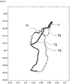
- the figure 6 and 7 represent two maps of the Lyon metropolitan area. For the sake of readability of the maps, the roads are not represented.
- the figure 6 illustrates the path to be characterized T and the first prior path T1, as well as several L links between the points of the first path to be characterized T and the first prior path T1 are represented (all of these links are not represented).
- the map of the figure 7 illustrates the path to be characterized T and the second prior path T2, as well as several L links between the points of the first path to be characterized T and the second prior path T2 are shown (all of these links are not shown).
- the path to be characterized T is similar to the previous path T2, in fact, the path to be characterized T is partly superimposed on the previous path T2.
- the discrete modified Fréchet distance is determined according to the method according to the invention.
- the discrete modified Fréchet distance is 2241 m
- the discrete modified Fréchet distance is 41 m.
- the second example corresponds to the embodiment of the figure 4 : determining the mode of transport using a multimodal travel planning tool.
- different routes are determined using the multimodal trip planning tool.
- the figure 8 represents a map of the Lyon metropolitan area. For the sake of readability of the maps, the roads are not represented.
- the figure 8 illustrates the route T traveled represented by crosses and the different routes T3, T4, T5, T6 obtained by the multimodal trip planning tool. In this case, the route to be characterized appears as a sub-route of a set of routes obtained by the multimodal trip planning tool.
- the modified Fréchet distance of path T3 is 129.58m, that of path T4 is 130.53 m, that of path T5 is 18.61m, and that of path T6 is 19.75 m.
- the path can be assigned the transport mode of the path T5, which minimizes the discrete modified Fréchet distance. Thanks to this, it can be determined that the route traveled was made by means of the Lyon tramway T1, which corresponds well to what was entered by the user.
- the method according to the invention makes it possible to robustly characterize a path traveled by a user, by means of measurements by a geolocation sensor.
Abstract
La présente invention concerne un procédé de caractérisation d'un trajet (T) parcouru par un utilisateur. Le procédé comprend une étape de mesure (MES) de localisation et d'horodatage pendant le trajet, puis une étape de détermination d'une distance de Fréchet modifiée discrète (DFM) entre le trajet mesuré et des trajets antérieurs. Enfin, la distance de Fréchet modifiée discrète (DFM) est utilisée pour caractériser le trajet à caractériser (T).The present invention relates to a method for characterizing a path (T) traveled by a user. The method comprises a step of measuring (MES) location and timestamping during the journey, then a step of determining a discrete modified Fréchet distance (DFM) between the measured path and previous journeys. Finally, the discrete modified Fréchet distance (DFM) is used to characterize the path to be characterized (T).
Description
La présente invention concerne le domaine de la caractérisation d'un trajet parcouru par un utilisateur, notamment la caractérisation de l'appartenance du trajet parcouru avec un regroupement (groupe, ou en anglais « cluster ») de trajets antérieurs, et/ou de la caractérisation du mode de transport de l'utilisateur.The present invention relates to the field of the characterization of a path traveled by a user, in particular the characterization of the membership of the path traveled with a grouping (group, or in English "cluster") of previous paths, and/or of the characterization of the mode of transport of the user.
Le domaine du transport revêt un aspect essentiel de la vie quotidienne dont l'économie mondiale dépend fortement. Cependant, il joue également un rôle majeur dans la dégradation de la qualité de l'air et dans l'augmentation des émissions de CO2, en particulier dans les zones urbaines. Selon l'Organisation Mondiale de la Santé (OMS), le transport est l'une des principales sources de pollution atmosphérique, et il est directement lié à de multiples maladies respiratoires et cardiovasculaires. En outre, le transport mondial est à l'origine d'environ 24 % des émissions directes de CO2 provenant de la combustion de carburants, dont près des trois quarts correspondent aux voitures, camions, bus et motos, ce qui aggrave encore le phénomène de réchauffement climatique. Parmi les autres types d'émissions nocives figurent les oxydes d'azote (NOx), l'ozone troposphérique (O3) et les particules (PM), qui dépassent généralement les limites recommandées. L'importance du rôle des transports dans la qualité de l'air se reflète également dans le nombre croissant d'actions politiques menées en Europe au cours des dernières années, ce qui en fait un sujet central. Les stratégies visant à s'attaquer à ce problème sont notamment les suivantes : normes en matière d'efficacité des véhicules et des carburants à faible teneur en carbone, développement et incitations de véhicules à faibles émissions, politiques fiscales et régimes d'imposition.The field of transport is an essential aspect of daily life on which the global economy depends heavily. However, it also plays a major role in degrading air quality and increasing CO 2 emissions, especially in urban areas. According to the World Health Organization (WHO), transport is one of the main sources of air pollution, and it is directly linked to multiple respiratory and cardiovascular diseases. In addition, the global transport is responsible for about 24% of direct CO 2 emissions from combustion of fuels, including nearly three quarters correspond to cars, trucks, buses and motorcycles, which exacerbates the phenomenon of global warming. Other types of harmful emissions include nitrogen oxides (NOx), ground-level ozone (O 3 ) and particulate matter (PM), which generally exceed recommended limits. The importance of the role of transport in air quality is also reflected in the growing number of political actions carried out in Europe in recent years, which makes it a central subject. Strategies to address this issue include: low-carbon vehicle and fuel efficiency standards, low-emission vehicle development and incentives, fiscal policies and taxation regimes.
Néanmoins, un aspect très important qui n'a pas encore été étudié de manière approfondie est l'impact direct du choix du mode de transport sur les émissions polluantes. En effet, à partir d'informations relatives à un trajet, on peut envisager mettre en oeuvre des initiatives pour encourager les utilisateurs à faire des choix alternatifs et plus respectueux de l'environnement.Nevertheless, a very important aspect which has not yet been studied in depth is the direct impact of the choice of mode of transport on polluting emissions. Indeed, from information relating to a journey, it is possible to consider implementing initiatives to encourage users to make alternative choices that are more respectful of the environment.
D'autre part, le développement technologique des appareils portables et de la communication sans fil s'est accéléré ces dernières années, notamment grâce aux systèmes de géolocalisation (par exemple GPS de l'anglais « Global Positioning System »), au moyen d'un téléphone intelligent, etc. Il est ainsi possible d'extraire tous types d'informations concernant les déplacements des utilisateurs dans le monde entier : le mode de transport utilisé est une information particulièrement précieuse. Toutefois, il est difficile d'identifier le mode de transport utilisé de manière fiable à partir de mesures, il est également difficile d'imposer à une utilisation de labéliser manuellement pour chaque trajet une donnée relative au mode de transport dans une application, pour associer les mesures à un mode de transport. Une première approche pour identifier le mode de transport peut consister en une approche basée sur la vitesse. Il est à noter qu'une telle approche basée sur la vitesse présente de graves défauts puisqu'elle ignore des phénomènes courants tels que le trafic ou les conditions météorologiques. Il existe, par conséquent, un besoin d'identification du mode de transport en utilisant les ensembles de données disponibles provenant des appareils mobiles équipés de système de géolocalisation.On the other hand, the technological development of portable devices and wireless communication has accelerated in recent years, in particular thanks to geolocation systems (for example GPS from the English "Global Positioning System"), by means of a smart phone, etc. It is thus possible to extract all types of information concerning the movements of users around the world: the mode of transport used is particularly valuable information. However, it is difficult to reliably identify the mode of transport used from measurements, it is also difficult to impose on a user to manually label for each journey data relating to the mode of transport in an application, to associate measurements to a mode of transport. A first approach to identify the mode of transport can consist of an approach based on speed. It should be noted that such a speed-based approach has serious flaws since it ignores common phenomena such as traffic or weather conditions. There is, therefore, a need for identification of the mode of transport using the datasets available from mobile devices equipped with geolocation systems.
De plus, une première étape naturelle vers cet objectif d'identification du mode de transport, consiste à réduire l'ampleur des données en regroupant les trajectoires en regroupements représentatifs (groupe, ou en anglais « clusters ») présentant des caractéristiques similaires. Chaque groupe peut avoir un représentant pour lequel le mode de transport est facilement disponible.In addition, a natural first step towards this objective of identifying the mode of transport, consists in reducing the magnitude of the data by grouping the trajectories into representative groupings (groups, or in English “clusters”) presenting similar characteristics. Each group can have one representative for whom transportation is readily available.
La stratégie de regroupement des trajectoires nécessite toutefois une méthode soigneusement choisie pour mesurer la similarité entre deux trajectoires données ; les données GPS brutes ont tendance à être asynchrones, sous-échantillonnées et avec des taux d'échantillonnage variables.The trajectory clustering strategy, however, requires a carefully chosen method to measure the similarity between two given trajectories; raw GPS data tends to be asynchronous, undersampled, and with varying sample rates.
Le regroupement de trajectoires géographiques sur la base d'une mesure de similarité totale ou partielle peut être utilisé pour un vaste domaine d'applications, par exemple : connaissance des tendances des utilisateurs, prévision de la mobilité, contrôle du trafic et planification optimale des déplacements. En effet, la méthode de regroupement peut être interprétée comme une technique de réduction des données afin de résumer l'activité de déplacement de l'utilisateur sur une longue période et avec une résolution spatio-temporelle élevée.The grouping of geographical trajectories based on a measure of full or partial similarity can be used for a wide range of applications, for example: knowledge of user trends, mobility forecasting, traffic control and optimal trip planning. . Indeed, the clustering method can be interpreted as a data reduction technique in order to summarize the user's travel activity over a long period and with a high spatio-temporal resolution.
La mesure de la similarité entre une paire de trajets est de la plus haute importance dans un nombre croissant d'applications ; les notions de distances entre trajectoires sont au cœur de problèmes tels que le regroupement, la classification des trajectoires. Les choix habituels de mesures de similarité, pour lesquelles il existe de multiples variantes, comprennent notamment les méthodes basées sur les distances de Fréchet, la mesure de la distorsion temporelle dynamique (DTW), Hausdorff et euclidiennes, ainsi que ce qu'on appelle la plus longue suite commune (LCSS). Cependant, les deux premières mesures tendent à être un choix plus approprié pour l'étude des trajectoires des véhicules étant donné leur nature continue et ordonnée.Measuring the similarity between a pair of paths is of utmost importance in an increasing number of applications; the notions of distances between trajectories are at the heart of problems such as grouping and classification of trajectories. Common choices of similarity measures, for which there are multiple variations, include methods based on Fréchet distances, Dynamic Time Distortion (DTW), Hausdorff, and Euclidean methods, as well as so-called Longest Common Suite (LCSS). However, the first two bars tend to be a more appropriate choice for the study of vehicle trajectories given their continuous and ordered nature.
Par exemple, la distance dite de Fréchet offre un compromis efficace entre généralité et spécificité. En effet, elle est invariante par rapport à la vitesse de la trajectoire, mais dépend fortement du flux continu de la trajectoire. La distance de Fréchet entre la trajectoire A et B peut être décrite de manière informelle comme la longueur de la laisse la plus courte permettant à une personne sur un trajet A de promener un chien sur un trajet B (sans faire marche arrière). La mesure de la distorsion temporelle dynamique (DTW), introduite dans le domaine de la reconnaissance vocale comme mesure de similarité entre des séries temporelles, est également pertinente.For example, the so-called Fréchet distance offers an effective compromise between generality and specificity. Indeed, it is invariant with respect to the velocity of the trajectory, but strongly depends on the continuous flow of the trajectory. The Fréchet distance between path A and B can be informally described as the shortest leash length allowing a person on path A to walk a dog on path B (without backing up). The measure of dynamic temporal distortion (DTW), introduced in the field of speech recognition as a measure of similarity between time series, is also relevant.
Dans sa version continue, la distance de Fréchet est donnée par la formule :
![]()
![]()
Pour une autre application, la distance de Fréchet a été utilisée notamment dans la méthode décrite dans la demande de brevet
Une autre difficulté liée à la mesure par système de géolocalisation, ou par téléphone intelligent, est le nombre limité de mesures disponibles pour certains tronçons, notamment des tronçons souterrains. Avec de telles mesures tronquées, il est difficile de caractériser de manière fiable et robuste un trajet parcouru.Another difficulty related to measurement by geolocation system, or by smartphone, is the limited number of measurements available for certain sections, in particular underground sections. With such truncated measurements, it is difficult to reliably and robustly characterize a path travelled.
Bien que la recherche concernant les distances inter-trajectoires est extrêmement vaste, les performances des algorithmes de regroupement correspondants ont fait l'objet d'une attention moindre. Les méthodes de regroupement les plus courantes sont les suivantes : k-means ou medoid, regroupement spectral, dbscan et analyse de regroupement hiérarchique. Cette dernière a été utilisée pour prédire la destination des conducteurs en ce qui concerne la forme des courbes, tel que décrit notamment dans le document
Le document
La présente invention a pour but de caractériser un trajet parcouru par un utilisateur de manière robuste, même avec des mesures comprenant des valeurs aberrantes, ou des mesures tronquées (nombre de mesures limités pour certaines portions du trajet). Dans ce but, la présente invention concerne un procédé de caractérisation d'un trajet parcouru par un utilisateur. Le procédé comprend une étape de mesure de localisation et d'horodatage pendant le trajet, puis une étape de détermination d'une distance modifiée de Fréchet discrète entre le trajet mesuré et des trajets antérieurs. Enfin, la distance modifiée de Fréchet discrète est utilisée pour caractériser le trajet à caractériser. La distance modifiée de Fréchet discrète permet de déterminer les trajets antérieurs similaires de manière robuste. L'invention concerne un procédé de caractérisation d'un trajet parcouru par un utilisateur, au moyen d'une base de données comportant des données d'une pluralité de trajets antérieurs. Pour ce procédé, on met en œuvre les étapes suivantes :
- a) On mesure au moyen d'un capteur de géolocalisation la position et l'horodatage d'une pluralité de points dudit trajet à caractériser ;
- b) Pour au moins deux trajets antérieurs de ladite base de données, on détermine une distance entre ledit trajet à caractériser et chacun desdits au moins deux trajets antérieurs au moyen de la distance modifiée de Fréchet discrète en mettant en œuvre les étapes suivantes :
- i) On détermine un séquencement optimal de couples de points entre ledit trajet à caractériser et ledit trajet antérieur, en minimisant la distance entre lesdits couples de points ;
- ii) On détermine ladite distance modifiée de Fréchet discrète par la moyenne desdites distances entre lesdits couples de points dudit séquencement optimal ;
- c) On caractérise ledit trajet à caractériser par une comparaison desdites distances déterminées entre lesdits au moins deux trajets antérieurs de ladite base de données et ledit trajet à caractériser.
- a) The position and timestamp of a plurality of points of said path to be characterized are measured by means of a geolocation sensor;
- b) For at least two previous paths of said database, a distance is determined between said path to be characterized and each of said at least two previous paths by means of the modified discrete Fréchet distance by implementing the following steps:
- i) An optimal sequencing of pairs of points is determined between said path to be characterized and said previous path, by minimizing the distance between said pairs of points;
- ii) Said modified discrete Fréchet distance is determined by the average of said distances between said pairs of points of said optimal sequencing;
- c) Said path to be characterized is characterized by a comparison of said distances determined between said at least two previous paths of said database and said path to be characterized.
Selon un mode de réalisation, ladite caractérisation concerne le classement dudit trajet à caractériser dans un regroupement représentatif de trajets.According to one embodiment, said characterization concerns the classification of said path to be characterized in a representative grouping of paths.
Selon un mode de réalisation, ladite caractérisation concerne la détermination d'au moins un mode de transport dudit utilisateur pour ledit trajet à caractériser.According to one embodiment, said characterization concerns the determination of at least one mode of transport of said user for said path to be characterized.
Avantageusement, on segmente ledit trajet à caractériser en au moins deux sous-trajets, et on détermine ledit au moins un mode de transport dudit utilisateur pour chaque sous-trajet. De manière avantageuse, on détermine ledit au moins un mode de transport par comparaison avec un outil de planification de déplacement multimodal.Advantageously, said path to be characterized is segmented into at least two sub-paths, and said at least one mode of transport of said user is determined for each sub-path. Advantageously, said at least one mode of transport is determined by comparison with a multimodal travel planning tool.
De préférence, ledit outil de planification mutlimodal comporte une cartographie des déplacements et des données de transport en commun.Preferably, said multimodal planning tool includes travel mapping and public transport data.
Conformément à une mise en œuvre, on compare chaque distance modifiée de Fréchet discrète déterminée avec un seuil, de préférence ledit seuil est inférieur à 500 m, et de manière préférentielle ledit seuil est inférieur à 250 m, et on met en œuvre la caractérisation au moyen des étapes suivantes :
- i) Si ladite distance modifiée de Fréchet discrète déterminée est inférieure ou égale audit seuil, alors on attribue audit trajet à caractériser la même caractérisation que ledit trajet antérieur correspondant, et
- ii) Si ladite distance modifiée de Fréchet discrète déterminée est supérieure audit seuil, alors on n'attribue aucune caractérisation audit trajet à caractériser.
- i) If said modified discrete Fréchet distance determined is less than or equal to said threshold, then said path to be characterized is assigned the same characterization as said corresponding previous path, and
- ii) If said modified discrete Fréchet distance determined is greater than said threshold, then no characterization is attributed to said path to be characterized.
Selon un aspect, on mesure au moins un paramètre complémentaire dudit trajet à caractériser, ledit paramètre complémentaire étant choisi parmi la vitesse dudit utilisateur, l'accélération dudit utilisateur, la précision dudit capteur de géolocalisation, l'altitude dudit utilisateur, et on met en œuvre un critère supplémentaire pour caractériser ledit trajet à caractériser en fonction dudit paramètre complémentaire.According to one aspect, at least one complementary parameter of said path to be characterized is measured, said complementary parameter being chosen from among the speed of said user, the acceleration of said user, the accuracy of said geolocation sensor, the altitude of said user, and implements an additional criterion to characterize said path to be characterized as a function of said additional parameter.
Selon une caractéristique, on détermine ladite distance modifiée de Fréchet discrète en limitant, dans ledit séquencement optimal de couples de points, le nombre de liaisons pour un unique point d'un trajet, de préférence le nombre limite de liaisons est compris entre 3 et 10, de manière préférée entre 4 et 7.According to one characteristic, said modified discrete Fréchet distance is determined by limiting, in said optimal sequencing of pairs of points, the number of links for a single point of a path, preferably the limit number of links is between 3 and 10 , preferably between 4 and 7.
Conformément à une option, on détermine ladite distance modifiée de Fréchet discrète après éliminations des valeurs maximales de la distance dans ledit séquencement optimal de couples de points.According to one option, said modified discrete Fréchet distance is determined after elimination of the maximum values of the distance in said optimal sequencing of pairs of points.
Conformément à un mode de réalisation, le procédé comporte en outre une étape de prétraitement des mesures par une interpolation spatiale en distance.According to one embodiment, the method further comprises a step of pre-processing the measurements by spatial distance interpolation.
Selon une mise en œuvre, ladite base de données desdits trajets antérieurs comporte uniquement des trajets antérieurs dudit utilisateur, avec au moins les données de géolocalisation et d'horodatages desdits trajets antérieurs.According to one implementation, said database of said previous journeys comprises only previous journeys of said user, with at least the geolocation and timestamp data of said previous journeys.
Conformément à un aspect, ladite base de données comporte une information liée au mode de transport pour au moins un trajet antérieur.According to one aspect, said database includes information related to the mode of transport for at least one previous journey.
Selon un aspect, ladite base de données comporte au moins un groupement représentatif desdits trajets antérieurs.According to one aspect, said database includes at least one representative grouping of said previous journeys.
En outre, l'invention concerne un produit programme d'ordinateur téléchargeable depuis un réseau de communication et/ou enregistré sur un support lisible par ordinateur et/ou exécutable par un processeur ou un serveur, comprenant des instructions de code de programme pour la mise en œuvre du procédé selon l'une des caractéristiques précédentes, lorsque ledit programme est exécuté sur un ordinateur ou sur un téléphone portable.Furthermore, the invention relates to a computer program product downloadable from a communication network and/or recorded on a computer-readable medium and/or executable by a processor or a server, comprising program code instructions for implementation of the method according to one of the preceding characteristics, when said program is executed on a computer or on a mobile telephone.
D'autres caractéristiques et avantages du procédé selon l'invention, apparaîtront à la lecture de la description ci-après d'exemples non limitatifs de réalisations, en se référant aux figures annexées et décrites ci-après.Other characteristics and advantages of the method according to the invention will appear on reading the following description of non-limiting examples of embodiments, with reference to the appended figures and described below.
-
La
figure 1 illustre les étapes du procédé selon un premier mode de réalisation.Thefigure 1 illustrates the steps of the method according to a first embodiment. -
La
figure 2 illustre les étapes du procédé selon un deuxième mode de réalisation.Thefigure 2 illustrates the steps of the method according to a second embodiment. -
La
figure 3 illustre les étapes du procédé selon un troisième mode de réalisation.Thepicture 3 illustrates the steps of the method according to a third embodiment. -
La
figure 4 illustre les étapes du procédé selon un quatrième mode de réalisation.Thefigure 4 illustrates the steps of the method according to a fourth embodiment. -
La
figure 5 illustre la construction de la distance de Fréchet modifiée selon un mode de réalisation de l'invention.Thefigure 5 illustrates the construction of the modified Fréchet distance according to one embodiment of the invention. -
La
figure 6 illustre, pour un exemple, la détermination de la distance de Fréchet pour un trajet à caractériser avec un premier trajet antérieur.Thefigure 6 illustrates, for an example, the determination of the Fréchet distance for a path to be characterized with a first prior path. -
La
figure 7 illustre, pour un exemple, la détermination de la distance de Fréchet pour un trajet à caractériser avec un deuxième trajet antérieur.Thefigure 7 illustrates, for an example, the determination of the Fréchet distance for a path to be characterized with a second prior path. -
La
figure 8 illustre, pour un exemple, une identification du mode de transport par utilisation d'un outil de planification de déplacement.Thefigure 8 illustrates, for an example, an identification of the mode of transport by use of a travel planning tool.
La présente invention concerne un procédé de caractérisation d'un trajet parcouru par un utilisateur. On appelle trajet parcouru par un utilisateur, un déplacement réalisé par un utilisateur entre une origine et une destination avec tout moyen de locomotion (véhicule, bicyclette, transports en commun : bus, tramway, train, métro, déplacement à pieds, etc.). Sur un même trajet, l'utilisateur peut utiliser plusieurs moyens de locomotion différents, on parle alors de trajet multimodal (par exemple une combinaison de transports en commun, ou une combinaison de transports en commun et de déplacement à pieds, ou en bicyclette, etc.). On nomme dans la suite de la description le trajet parcouru par l'utilisateur, trajet à caractériser. La caractérisation concerne la détermination d'au moins une caractéristique représentative du trajet. Selon un mode de réalisation de l'invention préféré, la caractérisation peut concerner la détermination du ou des mode(s) de transport (c'est-à-dire du ou des moyen(s) de locomotion). Alternativement ou additionnellement, la caractérisation peut concerner l'appartenance du trajet à caractériser à un regroupement représentatif de trajets (à un « cluster »), les trajets appartenant à un même regroupement représentatif de trajets ayant des attributs similaires, en particulier des parcours similaires.The present invention relates to a method for characterizing a path traveled by a user. The term traveled by a user is a journey made by a user between an origin and a destination with any means of transport (vehicle, bicycle, public transport: bus, tram, train, metro, walking, etc.). On the same journey, the user can use several different means of transport, this is called a multimodal journey (for example a combination of public transport, or a combination of public transport and travel on foot, or by bicycle, etc. .). In the remainder of the description, the path traveled by the user is called the path to be characterized. The characterization concerns the determination of at least one characteristic representative of the path. According to a preferred embodiment of the invention, the characterization may concern the determination of the mode(s) of transport (that is to say the means(s) of locomotion). Alternatively or additionally, the characterization may relate to the belonging of the path to be characterized to a representative grouping of paths (to a “cluster”), the paths belonging to the same representative grouping of paths having similar attributes, in particular similar paths.
Le procédé de caractérisation utilise une base de données comportant des données de trajets antérieurs. Les trajets antérieurs sont des trajets parcourus antérieurement au trajet à caractériser, et pour lequel des données sont disponibles : en particulier la localisation, l'horodatage. La base de données peut comporter en outre d'autres données relatives aux trajets antérieurs, par exemple, le mode de transport, la vitesse de l'utilisateur, l'altitude de l'utilisateur, etc. La base de données peut être enregistrée sur une mémoire informatique. Selon un mode de réalisation de l'invention, la base de données peut comporter uniquement des données des trajets antérieurs de l'utilisateur du trajet à caractériser. Ainsi, la caractérisation du trajet peut être représentative des habitudes de l'utilisateur. En variante, la base de données peut comporter des données de trajets antérieurs de multiples utilisateurs. Ainsi la base de données peut comporter un grand nombre de trajets antérieurs, ce qui permet une meilleure précision de la caractérisation du trajet à caractériser.The characterization method uses a database comprising data from previous journeys. The previous paths are paths traveled prior to the path to be characterized, and for which data is available: in particular the location, the timestamp. The database may further comprise other data relating to previous journeys, for example, the mode of transport, the speed of the user, the altitude of the user, etc. The database may be stored on computer memory. According to one embodiment of the invention, the database can comprise only data from previous journeys of the user of the journey to be characterized. Thus, the characterization of the path can be representative of the habits of the user. Alternatively, the database may include data from past journeys of multiple users. Thus the database can comprise a large number of previous journeys, which allows better precision in the characterization of the journey to be characterized.
Le procédé selon l'invention comporte les étapes suivantes :
- Mesure de la position et horodatage du trajet à caractériser
- Détermination de distances modifiées de Fréchet discrètes
- Caractérisation du trajet à caractériser
- Measurement of the position and timestamp of the path to be characterized
- Determination of discrete modified Fréchet distances
- Characterization of the path to be characterized
Ces étapes seront décrites en détail dans la suite de la description. Les étapes de détermination de distances modifiées de Fréchet discrètes et de caractérisation peuvent être mises en œuvre par un système informatique. Un tel système informatique peut comprendre une mémoire informatique de stockage, un processeur de calcul, et des moyens de communication, notamment avec les moyens de mesure.These steps will be described in detail in the remainder of the description. The steps of determining discrete modified Fréchet distances and of characterization can be implemented by a computer system. Such a computer system can comprise a computer storage memory, a calculation processor, and communication means, in particular with the measurement means.
La
Selon un mode de réalisation de l'invention, le procédé peut comprendre une étape supplémentaire de prétraitement des mesures avant l'étape de détermination de distances de Fréchet modifiées. Cette étape de prétraitement des mesures permet d'améliorer l'échantillonnage de mesure.According to one embodiment of the invention, the method may comprise an additional step of pre-processing the measurements before the step of determining modified Fréchet distances. This step of pre-processing the measurements makes it possible to improve the measurement sampling.
Pour ce deuxième mode de réalisation, le procédé comporte les étapes suivantes :
- Mesure de la position et horodatage du trajet à caractériser
- Prétraitement des mesures
- Détermination de distances modifiées de Fréchet discrètes
- Caractérisation du trajet à caractériser
- Measurement of the position and timestamp of the path to be characterized
- Measurement preprocessing
- Determination of discrete modified Fréchet distances
- Characterization of the path to be characterized
Ces étapes seront décrites en détail dans la suite de la description. Les étapes de prétraitement des mesures, détermination de distances de Fréchet modifiées et de caractérisation peuvent être mises en œuvre par un système informatique. Un tel système informatique peut comprendre une mémoire informatique de stockage, un processeur de calcul, et des moyens de communication, notamment avec les moyens de mesure.These steps will be described in detail in the remainder of the description. The steps of preprocessing measurements, determining modified Fréchet distances and characterization can be implemented by a computer system. Such a computer system can comprise a computer storage memory, a calculation processor, and communication means, in particular with the measurement means.
La
Selon un mode de réalisation de l'invention, la base de données peut comprendre au moins un regroupement représentatif de trajets (« cluster »). Pour ce mode de réalisation, on peut déterminer la distance de Fréchet modifiée pour un seul trajet antérieur de chaque groupement représentatif de trajets, de préférence un trajet antérieur pour lequel on connaît le mode de transport. Ainsi, le nombre de distances de Fréchet modifiées déterminées est limité, ce qui diminue le temps de calcul.According to one embodiment of the invention, the database may comprise at least one representative grouping of routes (“cluster”). For this embodiment, the modified Fréchet distance can be determined for a single previous journey of each representative group of journeys, preferably a previous journey for which the mode of transport is known. Thus, the number of modified Fréchet distances determined is limited, which reduces the calculation time.
La
Les modes de réalisation des
Lors de cette étape, on mesure, au moyen d'un capteur de géolocalisation, la position et l'horodatage d'une pluralité de points du trajet à caractériser.During this step, the position and timestamp of a plurality of points of the path to be characterized are measured by means of a geolocation sensor.
Le capteur de géolocalisation peut être un capteur de positionnement par satellite, tel que le système GPS (de l'anglais Global Positioning System), le système Galileo, etc. Le capteur de géolocalisation peut être embarqué à bord du véhicule ou déporté (par exemple au moyen d'un téléphone intelligent, de l'anglais « smartphone »). De préférence, le capteur de géolocalisation peut être déporté dans un téléphone intelligent, de manière à être adapté à tout type de mode de transport.The geolocation sensor can be a satellite positioning sensor, such as the GPS system (Global Positioning System), the Galileo system, etc. The geolocation sensor can be on board the vehicle or deported (for example by means of a smart telephone, English “smartphone”). Preferably, the geolocation sensor can be deported in a smart phone, so as to be suitable for any type of mode of transport.
L'horodatage peut être utilisé notamment pour le prétraitement (cf. étape suivante).The timestamp can be used in particular for preprocessing (see next step).
Alternativement, on peut également procéder à l'interpolation avec un horodatage virtuel.Alternatively, the interpolation can also be carried out with a virtual timestamp.
On rappelle que cette étape est facultative, et correspond au deuxième mode de réalisation de l'invention illustré en
En effet, les mesures étant réalisées par le capteur de géolocalisation de manière discrète, la première étape permet de connaître la géolocalisation d'une pluralité de points de mesure. Toutefois, en raison d'un arrêt du véhicule, et en raison de l'imprécision pouvant être liée au capteur de géolocalisation, aux conditions météorologiques, à la traversée d'un tunnel, etc., la mesure du trajet à caractériser peut comprendre plusieurs points de mesure plus ou moins éloignés, alors qu'ils correspondent théoriquement au même point physique du trajet parcouru. Cette disparité des points de mesure peut générer une détermination des distances de Fréchet moyennée moins cohérente, ce qui peut générer une caractérisation moins précise du trajet à caractériser.Indeed, the measurements being carried out by the geolocation sensor in a discrete manner, the first step makes it possible to know the geolocation of a plurality of measurement points. However, due to a stoppage of the vehicle, and due to the inaccuracy that may be linked to the geolocation sensor, weather conditions, crossing a tunnel, etc., the measurement of the journey to be characterized may include several measurement points more or less distant, while they theoretically correspond to the same physical point of the path travelled. This disparity of the measurement points can generate a less consistent determination of the averaged Fréchet distances, which can generate a less precise characterization of the path to be characterized.
Selon un exemple de mise en œuvre, ce pré-traitement permet d'échantillonner les données afin d'avoir un point tous les 50m (ou 25m, 100m, 150m, etc.). En effet, généralement le capteur de géolocalisation de type GPS peut réaliser la mesure à une fréquence de 1Hz donc lorsque l'utilisateur s'arrête par exemple à un feu rouge, on a beaucoup de points au même endroit, ce qui peut augmenter la distance de Fréchet sans qu'il n'y ait de déplacements.According to an example of implementation, this pre-processing makes it possible to sample the data in order to have a point every 50m (or 25m, 100m, 150m, etc.). Indeed, generally the GPS-type geolocation sensor can perform the measurement at a frequency of 1Hz so when the user stops for example at a red light, there are many points in the same place, which can increase the distance de Fréchet without having to travel.
Lors de cette étape, pour au moins deux trajets antérieurs de la base de données, on détermine une distance entre le trajet à caractériser et le trajet antérieur au moyen de la distance modifiée de Fréchet discrète. On rappelle que la distance de Fréchet « classique » entre la trajectoire A et B peut être décrite de manière informelle comme la longueur de la laisse la plus courte permettant à une personne sur un trajet A de promener un chien sur un trajet B (sans faire marche arrière). On appelle la distance modifiée de Fréchet discrète une détermination d'une distance se basant sur la méthode mise en œuvre pour le calcul de la distance Fréchet « classique », mais en ne calculant pas la distance la plus grande entre les points des deux trajets considérés, mais une moyenne des distances entre les deux trajets considérés de manière discrète. Cette distance modifiée de Fréchet discrète permet de s'affranchir de certaines mesures aberrantes.During this step, for at least two previous paths of the database, a distance is determined between the path to be characterized and the previous path by means of the modified discrete Fréchet distance. Remember that the "classic" Fréchet distance between trajectory A and B can be informally described as the length of the shortest leash allowing a person on path A to walk a dog on path B (without reverse). We call the modified discrete Fréchet distance a determination of a distance based on the method implemented for the calculation of the "classic" Fréchet distance, but by not calculating the greatest distance between the points of the two paths considered. , but an average of the distances between the two paths considered in a discrete way. This discrete modified Fréchet distance makes it possible to overcome certain aberrant measurements.
Pour la distance modifiée de Fréchet discrète, on construit de la même manière que pour la distance de Fréchet classique :
- une polyligne reliant les points du trajet à caractériser,
- une polyligne reliant les points du trajet antérieur, et ensuite
- l'ensemble des liaisons qui relient un point de chaque polyligne.
- a polyline connecting the points of the path to characterize,
- a polyline connecting the points of the previous path, and then
- the set of links that connect a point of each polyline.
L'étape de détermination des liaisons qui relient un point de chaque polyligne est effectuée de manière dynamique et récursive. Deux trajets discrets X et Y de longueurs respectives N et M sont considérés ici. La première étape concerne la construction d'une matrice de distance cumulative notée D qui contient à la ligne n, et colonne m, la distance de Fréchet discrète calculée du début de chaque trajet jusqu'au points n et m (où 1 ≤ n ≤ N et 1 ≤ m ≤ M). On peut alors écrire : ![]()
![]()
Avec Fd la version discrète de la distance de Fréchet, Xn, Ym les trajets tronqués de longueur n et m. La différence entre la version continue et discrète de la distance de Fréchet vient du fait que l'on ne considère pas les paramétrisations α et β comme des fonctions continues du temps mais uniquement l'ordonnancement des liaisons des trajets.With F d the discrete version of the Fréchet distance, Xn, Ym the truncated paths of length n and m. The difference between the continuous and discrete version of the Fréchet distance comes from the fact that the parametrizations α and β are not considered as continuous functions of time but only the scheduling of the links of the paths.
La matrice peut être calculée récursivement comme suit: ![]()
![]()
Où xn correspond au nième élément du trajet X et ym le mième élément du trajet Y, et d la distance entre le nième élément du trajet X et le mième élément du trajet Y.Where x n corresponds to the nth element of path X and y m the mth element of path Y, and d the distance between the nth element of path X and the mth element of path Y.
La construction des liens est alors réalisée dans le sens inverse (en partant des points N et M jusqu'au début des deux trajets) en définissant les paires de points avec la distance minimal soit : ![]()
![]()
On obtient alors le séquencement optimal P = [Pn, ...P 1] où chaque Pi représente un couple de point xk et yl . En parallèle, il est possible d'obtenir la séquence de distance optimale d* = [dn, ..., d 1] où di représente la distance métrique entre les points xk et yl associées à Pi .The optimal sequencing P=[ P n , ... P 1 ] is then obtained where each P i represents a pair of points x k and y l . In parallel, it is possible to obtain the optimal distance sequence d * = [ d n , ..., d 1 ] where d i represents the metric distance between the points x k and y l associated with P i .
Une modification pouvant être apportée par l'invention peut consister à saturer le nombre de liens par point à savoir, si xk (ou yl ) apparait plus de sat fois dans le séquencement P (et respectivement dans la séquence d*), on supprime les Pi qui contiennent xk (ou yl ) et on obtient alors un séquencement Psαt (et respectivement dans une séquence ![]()
![]()
Enfin, la distance modifiée de Fréchet discrète s'obtient en prenant la moyenne de la séquence de distance d* ou ![]()
![]()
Alternativement, la distance modifiée de Fréchet discrète peut s'obtenir en prenant la moyenne tronquée de la séquence de distance. La moyenne tronquée d'un vecteur est une mesure de moyenne arithmétique en éliminant les valeurs extrêmes. Selon un exemple de réalisation, afin de se prémunir des mesures aberrantes, la moyenne tronquée peut n'élimer que les valeurs les plus grandes. On appelle cette distance « distance modifiée de Fréchet discrète tronquée ».Alternatively, the discrete modified Fréchet distance can be obtained by taking the truncated mean of the distance sequence. The truncated mean of a vector is a measure of arithmetic mean by eliminating extreme values. According to an exemplary embodiment, in order to guard against aberrant measurements, the truncated mean can eliminate only the largest values. This distance is called “truncated discrete modified Fréchet distance”.
Selon ce mode de réalisation, afin d'augmenter la disponibilité de trajets potentiellement similaires, il est également possible de calculer par la suite la distance modifiée de Fréchet discrète en inversant l'ordre du trajet X (le dernier point devient le premier, etc.). Il convient finalement de sélectionner la distance la plus faible entre les deux calculs (X par rapport à Y et Xinv par rapport Y). Ce mode de réalisation permet de garantir la robustesse du procédé par rapport au sens du trajet. En effet, si l'utilisateur parcourt le trajet X de Xn à X1 et que ce trajet est comparé avec un trajet antérieur qui va de X1 à Xn, et si la distance modifiée de Fréchet discrète est calculée entre ces deux trajets, elle risque d'être très grande ce qui peut être pénalisant car il s'agit du même trajet parcouru en sens inverse.According to this embodiment, in order to increase the availability of potentially similar paths, it is also possible to subsequently calculate the modified discrete Fréchet distance by reversing the order of the path X (the last point becomes the first, etc. ). It is finally advisable to select the smallest distance between the two calculations (X compared to Y and X inv compared to Y ). This embodiment makes it possible to guarantee the robustness of the method with respect to the direction of the path. Indeed, if the user travels the path X from Xn to X1 and this path is compared with a previous path which goes from X1 to Xn, and if the distance modified from Discrete Fréchet is calculated between these two paths, it risks being very large which can be penalizing because it is the same path traveled in the opposite direction.
La
Selon un mode de réalisation, on peut déterminer la distance de Fréchet modifiée discrète en limitant le nombre de liaisons pour un unique point d'un trajet, de préférence le nombre limite de liaisons est compris entre 3 et 10, de manière préférée entre 4 et 7, et peut valoir 5. En d'autres termes, pour ce mode de réalisation, le nombre de liens partant de chaque point est limité. En référence à la
Lors de cette étape, on caractérise le trajet à caractériser par une comparaison des distances modifiées de Fréchet discrètes déterminées à l'étape précédente entre les au moins deux trajets antérieurs de ladite base de données et le trajet à caractériser.During this step, the path to be characterized is characterized by a comparison of the modified discrete Fréchet distances determined in the previous step between the at least two previous paths of said database and the path to be characterized.
Selon un mode de réalisation, on peut comparer chaque distance de Fréchet modifiée discrète déterminée à l'étape précédente avec un seuil, de préférence ledit seuil est inférieur à 500 m, et de manière préférentielle ledit seuil est inférieur à 250 m, et on peut mettre en œuvre la caractérisation au moyen des étapes suivantes :
- i) Si la distance modifiée de Fréchet discrète déterminée est inférieure ou égale au seuil, alors on attribue au trajet à caractériser la même caractérisation que le trajet antérieur correspondant, et
- ii) Si la distance modifiée de Fréchet discrète déterminée est supérieure au seuil, alors on n'attribue aucune caractérisation au trajet à caractériser.
- i) If the modified discrete Fréchet distance determined is less than or equal to the threshold, then the path to be characterized is assigned the same characterization as the corresponding previous path, and
- ii) If the modified discrete Fréchet distance determined is greater than the threshold, then no characterization is attributed to the path to be characterized.
Cette gamme de seuils permet d'identifier des trajets similaires. De préférence, le seuil peut valoir sensiblement 200m.This range of thresholds makes it possible to identify similar paths. Preferably, the threshold can be approximately 200m.
Alternativement, on peut attribuer au trajet à caractériser la caractérisation du trajet antérieur qui minimise la distance de Fréchet modifiée discrète. Selon une autre alternative, on peut cumuler les deux critères : on peut comparer la valeur minimale à un seuil, et on peut caractériser le trajet à caractériser si la valeur minimale est inférieure au seuil.Alternatively, the path to be characterized can be assigned the characterization of the previous path which minimizes the discrete modified Fréchet distance. According to another alternative, the two criteria can be combined: the minimum value can be compared with a threshold, and the path to be characterized can be characterized if the minimum value is less than the threshold.
Conformément à un mode de réalisation de l'invention, on peut mesurer au moins un paramètre complémentaire du trajet à caractériser, le paramètre complémentaire pouvant être choisi parmi la vitesse de l'utilisateur, l'accélération de l'utilisateur, la précision du capteur de géolocalisation, l'altitude de l'utilisateur, et on peut mettre en œuvre un critère supplémentaire pour caractériser le trajet à caractériser en fonction du paramètre complémentaire. Par exemple, grâce à la distance de Fréchet modifiée discrète réduite (c'est-à-dire minimale et/ou inférieure à un seuil), on peut connaître le parcours du trajet à caractériser, et on peut savoir quel type de chemin a été parcouru (ville, autoroute, piste cyclable, etc.), et grâce à la vitesse de déplacement de l'utilisateur, on peut différencier le mode de transport et/ou le regroupement représentatif des trajets.According to one embodiment of the invention, it is possible to measure at least one additional parameter of the path to be characterized, the additional parameter being able to be chosen from among the speed of the user, the acceleration of the user, the precision of the sensor of geolocation, the altitude of the user, and an additional criterion can be implemented to characterize the path to be characterized as a function of the complementary parameter. For example, thanks to the reduced discrete modified Fréchet distance (i.e. minimum and/or less than a threshold), one can know the path of the path to be characterized, and one can know what type of path has been traveled (city, highway, cycle path, etc.), and thanks to the speed of movement of the user, it is possible to differentiate the mode of transport and/or the representative grouping of journeys.
Selon une option de réalisation, cette étape peut comporter également l'enregistrement du trajet parcouru et caractérisé dans la base de données des trajets antérieurs. Le trajet parcouru et caractérisé devient alors un trajet antérieur pour la réitération du procédé pour un autre trajet parcouru par l'utilisateur. Ainsi, la base de données est complétée à chaque utilisation, ce qui favorise la fiabilité de la caractérisation.According to one implementation option, this step can also include the recording of the path traveled and characterized in the database of previous paths. The path traveled and characterized then becomes a previous path for the reiteration of the method for another path traveled by the user. Thus, the database is completed with each use, which promotes the reliability of the characterization.
Selon une première variante de cette étape, la caractérisation peut concerner l'appartenance du trajet à caractériser dans un regroupement représentatifs de trajets (« cluster »). Pour cette variante, on peut attribuer au trajet à caractériser le même regroupement représentatif de trajets que celui du trajet antérieur de la base de données (mode de réalisation de la
Selon une deuxième variante de cette étape, la caractérisation peut concerner la détection du mode de transport du trajet à parcourir. Quelle que soit la mise en œuvre de cette deuxième variante, pour cette étape, on peut segmenter le trajet à caractériser en sous-trajet, et on peut attribuer à chaque sous-trajet un mode de transport. Ainsi, cette réalisation permet de prendre en compte les trajets multimodaux (avec différents moyens de transport).According to a second variant of this step, the characterization may relate to the detection of the mode of transport of the route to be taken. Whatever the implementation of this second variant, for this step, the path to be characterized can be segmented into sub-paths, and a transport mode can be assigned to each sub-path. Thus, this realization makes it possible to take into account multimodal journeys (with different means of transport).
Une première mise en œuvre de cette variante peut consister à attribuer le mode de transport du trajet antérieur pour lequel la distance de Fréchet modifiée discrète est réduite (c'est-à-dire minimale et/ou inférieur à un seuil). Cette mise en œuvre nécessite qu'au moins un trajet antérieur de la base de données comporte une donnée relative au mode de transport de ce trajet antérieur.A first implementation of this variant may consist in allocating the mode of transport of the previous journey for which the discrete modified Fréchet distance is reduced (that is to say minimum and/or lower than a threshold). This implementation requires that at least one previous journey of the database includes data relating to the mode of transport of this previous journey.
Une deuxième mise en œuvre de cette variante peut consister à comparer le trajet à caractériser avec au moins un trajet obtenu avec un outil de planification de déplacement multimodal. Cet outil fournit des services d'analyse de transport et de planification de trajets multimodaux. Cet outil de planification multimodal peut comporter notamment une cartographie des déplacements et des données de transport en commun. Un trajet obtenu par cet outil peut être segmenté de manière à ce que le mode de transport spécifique soit bien défini pour chaque portion du trajet. La comparaison du trajet à caractériser avec au moins un trajet obtenu avec un outil de planification de déplacement multimodal peut être réalisé au moyen de la distance de Fréchet modifiée discrète mise en œuvre à l'étape précédente. On attribue alors au trajet à caractériser le ou les moyen(s) de transport correspondant au trajet obtenu par cet outil de planification de déplacement multimodal ayant une distance de Fréchet modifiée discrète réduite (valeur minimale et/ou inférieure à un seuil). Selon un aspect de cette mise en œuvre, l'outil de planification de déplacement multimodal peut être disponible en tant que service en ligne (« webservice »). Dans ce cas, les moyens informatiques mis en œuvre par le procédé selon l'invention peuvent comporter des moyens de connexion au service en ligne, notamment une connexion internet.A second implementation of this variant may consist in comparing the path to be characterized with at least one path obtained with a multimodal travel planning tool. This tool provides transportation analysis and multimodal trip planning services. This multimodal planning tool can include travel mapping and public transport data. A route obtained by this tool can be segmented in such a way that the specific mode of transport is well defined for each portion of the route. The comparison of the path to be characterized with at least one path obtained with a multimodal travel planning tool can be carried out by means of the discrete modified Fréchet distance implemented in the previous step. The route to be characterized is then assigned the means of transport corresponding to the route obtained by this multimodal trip planning tool having a reduced discrete modified Fréchet distance (minimum value and/or lower than a threshold). According to one aspect of this implementation, the multimodal travel planning tool may be available as an online service (“webservice”). In this case, the computer means implemented by the method according to the invention may comprise means of connection to the online service, in particular an Internet connection.
La
Selon une troisième variante de cette étape, la caractérisation peut concerner la détection du mode de transport du trajet à parcourir et l'appartenance du trajet à caractériser dans un regroupement représentatifs de trajets.According to a third variant of this step, the characterization may relate to the detection of the mode of transport of the route to be traversed and the membership of the route to be characterized in a representative grouping of routes.
Pour cette troisième variante, on peut combiner la première variante avec l'une des mises en œuvre de la deuxième variante décrite ci-dessus. Par exemple, on peut dans un premier temps déterminer l'appartenance du trajet à caractériser dans un regroupement représentatif de trajets. Puis, on attribue au trajet à caractériser le mode de transport correspondant au regroupement représentatif de trajets. Cet exemple de réalisation impose que chaque regroupement représentatif de trajets comporte au moins un trajet antérieur pour lequel un mode de transport est identifié.For this third variant, the first variant can be combined with one of the implementations of the second variant described above. For example, it is possible initially to determine the membership of the path to be characterized in a representative grouping of paths. Then, the mode of transport corresponding to the representative grouping of journeys is assigned to the route to be characterized. This exemplary embodiment imposes that each representative grouping of journeys comprises at least one previous journey for which a mode of transport is identified.
En outre, le procédé de caractérisation peut comprendre une étape de construction des regroupements représentatifs (« clusters ») de trajets de la base de données. Par exemple, cette étape de construction des regroupements représentatifs (« clusters ») peut être mise en œuvre par une application de la distance de Fréchet modifiée discrète en comparant par deux les trajets antérieurs de la base de données.In addition, the characterization method may include a step of constructing representative groupings (“clusters”) of paths from the database. For example, this step of constructing representative groupings (“clusters”) can be implemented by applying the discrete modified Fréchet distance by comparing the previous paths in the database in pairs.
Le procédé peut comporter une étape facultative d'affichage de la caractérisation du trajet parcouru. Lors de cette étape facultative, on peut afficher la caractérisation sur une carte routière. Cet affichage peut prendre la forme d'une note ou d'un code couleur (par exemple, une couleur par mode de transport et/ou une couleur par « cluster »). Cet affichage peut être réalisé à bord d'un véhicule : sur un dispositif portatif autonome, tel qu'un appareil de géolocalisation (de type GPS), un téléphone portable (de type téléphone intelligent). Il est également possible d'afficher la caractérisation du trajet à caractériser sur un site internet. L'invention concerne par ailleurs un produit programme d'ordinateur téléchargeable depuis un réseau de communication et/ou enregistré sur un support lisible par ordinateur et/ou exécutable par un processeur ou un serveur. Ce programme comprend des instructions de code de programme pour la mise en œuvre du procédé tel que décrit ci-dessus, lorsque le programme est exécuté sur un ordinateur ou un téléphone portable ou tout système analogue.The method may include an optional step of displaying the characterization of the route travelled. During this optional step, the characterization can be displayed on a road map. This display can take the form of a note or a color code (for example, one color per mode of transport and/or one color per “cluster”). This display can be produced on board a vehicle: on an autonomous portable device, such as a geolocation device (of the GPS type), a portable telephone (of the smart telephone type). It is also possible to display the characterization of the path to be characterized on a website. The invention also relates to a computer program product downloadable from a communication network and/or recorded on a computer-readable medium and/or executable by a processor or a server. This program comprises program code instructions for implementing the method as described above, when the program is executed on a computer or a mobile telephone or any similar system.
Les avantages du procédé selon l'invention ressortiront des exemples d'application décrits ci-après.The advantages of the method according to the invention will emerge from the application examples described below.
Pour les exemples, on caractérise des trajets mesurés par un capteur de géolocalisation au sein d'un téléphone intelligent. Les trajets mesurés et antérieurs sont situés dans la métropole Lyonnaise.For the examples, paths measured by a geolocation sensor within a smart telephone are characterized. The measured and previous journeys are located in the Lyon metropolitan area.
Pour le premier exemple, deux trajets antérieurs sont considérés, et on détermine la distance de Fréchet modifiée discrète entre le trajet à caractériser et chacun des deux trajets antérieurs, au moyen du procédé selon l'invention. Les
Le deuxième exemple correspond au mode de réalisation de la
Ainsi, le procédé selon l'invention permet de caractériser de manière robuste un trajet parcouru par un utilisateur, au moyen de mesures par une capteur de géolocalisation.Thus, the method according to the invention makes it possible to robustly characterize a path traveled by a user, by means of measurements by a geolocation sensor.
Claims (15)
Applications Claiming Priority (1)
| Application Number | Priority Date | Filing Date | Title |
|---|---|---|---|
| FR2007213A FR3112398B1 (en) | 2020-07-08 | 2020-07-08 | Method for characterizing a path traveled by a user |
Publications (1)
| Publication Number | Publication Date |
|---|---|
| EP3936824A1 true EP3936824A1 (en) | 2022-01-12 |
Family
ID=72801683
Family Applications (1)
| Application Number | Title | Priority Date | Filing Date |
|---|---|---|---|
| EP21179443.3A Pending EP3936824A1 (en) | 2020-07-08 | 2021-06-15 | Method for characterising a path travelled by a user |
Country Status (3)
| Country | Link |
|---|---|
| US (1) | US20220011123A1 (en) |
| EP (1) | EP3936824A1 (en) |
| FR (1) | FR3112398B1 (en) |
Cited By (1)
| Publication number | Priority date | Publication date | Assignee | Title |
|---|---|---|---|---|
| FR3132570A1 (en) * | 2022-02-09 | 2023-08-11 | IFP Energies Nouvelles | Method for determining at least one route between a geographic area of origin and a geographic area of destination |
Families Citing this family (1)
| Publication number | Priority date | Publication date | Assignee | Title |
|---|---|---|---|---|
| US11345342B2 (en) * | 2019-09-27 | 2022-05-31 | Intel Corporation | Potential collision warning system based on road user intent prediction |
Citations (1)
| Publication number | Priority date | Publication date | Assignee | Title |
|---|---|---|---|---|
| US20150354973A1 (en) | 2013-03-15 | 2015-12-10 | Hewlett-Packard Development Company, L.P. | Map matching |
Family Cites Families (7)
| Publication number | Priority date | Publication date | Assignee | Title |
|---|---|---|---|---|
| US20160362118A1 (en) * | 2011-08-31 | 2016-12-15 | Pulsar Informatics, Inc. | Driver performance metric |
| US8755967B1 (en) * | 2012-03-23 | 2014-06-17 | Google Inc. | Estimating road lane geometry using lane marker observations |
| US10427676B2 (en) * | 2017-05-31 | 2019-10-01 | GM Global Technology Operations LLC | Trajectory planner for autonomous driving using bézier curves |
| GB201414778D0 (en) * | 2014-08-20 | 2014-10-01 | Jaguar Land Rover Ltd | Route planning device and method |
| US10228259B2 (en) * | 2016-03-21 | 2019-03-12 | Ford Global Technologies, Llc. | Systems, methods, and devices for communicating drive history path attributes |
| US11099020B2 (en) * | 2019-05-28 | 2021-08-24 | Here Global B.V. | Method and apparatus for optimizing intermodal route computations |
| US11875678B2 (en) * | 2019-07-19 | 2024-01-16 | Zoox, Inc. | Unstructured vehicle path planner |
-
2020
- 2020-07-08 FR FR2007213A patent/FR3112398B1/en active Active
-
2021
- 2021-06-15 EP EP21179443.3A patent/EP3936824A1/en active Pending
- 2021-07-06 US US17/368,421 patent/US20220011123A1/en active Pending
Patent Citations (1)
| Publication number | Priority date | Publication date | Assignee | Title |
|---|---|---|---|---|
| US20150354973A1 (en) | 2013-03-15 | 2015-12-10 | Hewlett-Packard Development Company, L.P. | Map matching |
Non-Patent Citations (7)
| Title |
|---|
| BESSE PHILIPPE C ET AL: "Review and Perspective for Distance-Based Clustering of Vehicle Trajectories", IEEE TRANSACTIONS ON INTELLIGENT TRANSPORTATION SYSTEMS, IEEE, PISCATAWAY, NJ, USA, vol. 17, no. 11, 1 November 2016 (2016-11-01), pages 3306 - 3317, XP011627030, ISSN: 1524-9050, [retrieved on 20161028], DOI: 10.1109/TITS.2016.2547641 * |
| F. ASGARIA. SULTANH. XIONGV. GAUTHIERM.A. EI-YACOUBI: "Ct-mapper: mapping sparse multimodal cellular trajectories using a multilayer transportation network", COMPUT. COMMUN., vol. 95, 2016, pages 69 - 81 |
| F. ASGARIA. SULTANH. XIONGV. GAUTHIERM.A. EL-YACOUBI: "Ct-mapper: mapping sparse multimodal cellular trajectories using a multilayer transportation network", COMPUT. COMMUN., vol. 95, 2016, pages 69 - 81, XP055297966 * |
| JOHN DOYLE ET AL: "Utilising Mobile Phone Billing Records for Travel Mode Discovery", ISSC, 1 January 2011 (2011-01-01), XP055297821 * |
| P.C. BESSEB. GUILLOUETJ.-M. LOUBESF. ROYER: "Review and Perspective for Distance-based Clustering of Vehicle Trajectories", IEEE TRANSACTIONS ON INTELLIGENT TRANSPORTATION SYSTEMS, vol. 17, no. 11, 2016, pages 3306 - 3317, XP011627030, DOI: 10.1109/TITS.2016.2547641 |
| S. ATEVG. MILLERN.P. PAPANIKOLOPOULOS: "Clustering of Vehicle Trajectories", IEEE TRANSACTIONS ON INTELLIGENT TRANSPORTATION SYSTEMS, vol. 11, no. 3, 2010, pages 647 - 657 |
| ZBIGNIEW SMOREDA ET AL: "Spatiotemporal data from mobile phones for personal mobility assessment", 1 January 2013 (2013-01-01), XP055297817, Retrieved from the Internet <URL:http://citeseerx.ist.psu.edu/viewdoc/download?doi=10.1.1.649.8361&rep=rep1&type=pdf> [retrieved on 20210326], DOI: 10.1108/9781781902882-041 * |
Cited By (2)
| Publication number | Priority date | Publication date | Assignee | Title |
|---|---|---|---|---|
| FR3132570A1 (en) * | 2022-02-09 | 2023-08-11 | IFP Energies Nouvelles | Method for determining at least one route between a geographic area of origin and a geographic area of destination |
| EP4239289A1 (en) * | 2022-02-09 | 2023-09-06 | IFP Energies nouvelles | Method for determining at least one route between an original geographical area and a target geographical area |
Also Published As
| Publication number | Publication date |
|---|---|
| US20220011123A1 (en) | 2022-01-13 |
| FR3112398B1 (en) | 2022-10-14 |
| FR3112398A1 (en) | 2022-01-14 |
Similar Documents
| Publication | Publication Date | Title |
|---|---|---|
| JP6637054B2 (en) | Method and system for providing on-demand service information | |
| Newson et al. | Hidden Markov map matching through noise and sparseness | |
| US20080004789A1 (en) | Inferring road speeds for context-sensitive routing | |
| EP3462404A1 (en) | Method for determining indicators on the pollutant nature of mobility taking into account actual usage | |
| US20130322694A1 (en) | Energy Efficient Routing Using An Impedance Factor | |
| EP3936824A1 (en) | Method for characterising a path travelled by a user | |
| US11042648B2 (en) | Quantification of privacy risk in location trajectories | |
| Romanillos et al. | Cyclists do better. Analyzing urban cycling operating speeds and accessibility | |
| US20230066501A1 (en) | Method, apparatus, and system for traffic estimation based on anomaly detection | |
| WO2020239503A1 (en) | Method for predicting at least one profile of the speed of a vehicle on a road network | |
| EP4075408A1 (en) | Method for determining the amount of pollutant emissions emitted by a vehicle on a section of a road network | |
| EP3760506B1 (en) | Method for characterising the state of a road | |
| WO2020201243A1 (en) | Method for updating a road map based on a network of contributors | |
| FR3086053A1 (en) | MOST LIKELY ROUTE PREDICTION DEVICE OF A VEHICLE | |
| Meister et al. | Route choice modelling for cyclists on dense urban networks | |
| WO2013190233A1 (en) | Method for estimating a journey time of a vehicle on a road network | |
| US20220100796A1 (en) | Method, apparatus, and system for mapping conversation and audio data to locations | |
| WO2022229049A1 (en) | Methods and systems for determining estimated travel times through a navigable network | |
| Berjisian et al. | Evaluation of map‐matching algorithms for smartphone‐based active travel data | |
| JP4839409B2 (en) | Travel time prediction system, travel time prediction program, and navigation system | |
| EP3996064B1 (en) | Method for determining a number of passages of vehicles on at least one road portion of a road network | |
| Rehrl et al. | Which quality is a route? A methodology for assessing route quality using spatio‐temporal metrics | |
| EP4181100A1 (en) | Method for determining a maximum throughput and/or a daily throughput of vehicles on a road network | |
| FR3090148A1 (en) | MULTIMODAL MAPPING RECALING METHOD BASED ON HUMAN REPETITIVE BEHAVIOR | |
| EP4239289A1 (en) | Method for determining at least one route between an original geographical area and a target geographical area |
Legal Events
| Date | Code | Title | Description |
|---|---|---|---|
| PUAI | Public reference made under article 153(3) epc to a published international application that has entered the european phase |
Free format text: ORIGINAL CODE: 0009012 |
|
| STAA | Information on the status of an ep patent application or granted ep patent |
Free format text: STATUS: THE APPLICATION HAS BEEN PUBLISHED |
|
| AK | Designated contracting states |
Kind code of ref document: A1 Designated state(s): AL AT BE BG CH CY CZ DE DK EE ES FI FR GB GR HR HU IE IS IT LI LT LU LV MC MK MT NL NO PL PT RO RS SE SI SK SM TR |
|
| B565 | Issuance of search results under rule 164(2) epc |
Effective date: 20211105 |
|
| STAA | Information on the status of an ep patent application or granted ep patent |
Free format text: STATUS: REQUEST FOR EXAMINATION WAS MADE |
|
| 17P | Request for examination filed |
Effective date: 20220712 |
|
| RBV | Designated contracting states (corrected) |
Designated state(s): AL AT BE BG CH CY CZ DE DK EE ES FI FR GB GR HR HU IE IS IT LI LT LU LV MC MK MT NL NO PL PT RO RS SE SI SK SM TR |
|
| STAA | Information on the status of an ep patent application or granted ep patent |
Free format text: STATUS: EXAMINATION IS IN PROGRESS |
|
| 17Q | First examination report despatched |
Effective date: 20240103 |