EP3901580A1 - Navigation assistance method, navigation assistance device, and navigation assistance program - Google Patents
Navigation assistance method, navigation assistance device, and navigation assistance program Download PDFInfo
- Publication number
- EP3901580A1 EP3901580A1 EP18943973.0A EP18943973A EP3901580A1 EP 3901580 A1 EP3901580 A1 EP 3901580A1 EP 18943973 A EP18943973 A EP 18943973A EP 3901580 A1 EP3901580 A1 EP 3901580A1
- Authority
- EP
- European Patent Office
- Prior art keywords
- vessel
- meteorological
- data
- hydrographic
- pattern
- Prior art date
- Legal status (The legal status is an assumption and is not a legal conclusion. Google has not performed a legal analysis and makes no representation as to the accuracy of the status listed.)
- Withdrawn
Links
Images






Classifications
-
- G—PHYSICS
- G08—SIGNALLING
- G08G—TRAFFIC CONTROL SYSTEMS
- G08G3/00—Traffic control systems for marine craft
-
- G—PHYSICS
- G01—MEASURING; TESTING
- G01C—MEASURING DISTANCES, LEVELS OR BEARINGS; SURVEYING; NAVIGATION; GYROSCOPIC INSTRUMENTS; PHOTOGRAMMETRY OR VIDEOGRAMMETRY
- G01C21/00—Navigation; Navigational instruments not provided for in groups G01C1/00 - G01C19/00
- G01C21/10—Navigation; Navigational instruments not provided for in groups G01C1/00 - G01C19/00 by using measurements of speed or acceleration
-
- G—PHYSICS
- G01—MEASURING; TESTING
- G01C—MEASURING DISTANCES, LEVELS OR BEARINGS; SURVEYING; NAVIGATION; GYROSCOPIC INSTRUMENTS; PHOTOGRAMMETRY OR VIDEOGRAMMETRY
- G01C21/00—Navigation; Navigational instruments not provided for in groups G01C1/00 - G01C19/00
- G01C21/20—Instruments for performing navigational calculations
- G01C21/203—Instruments for performing navigational calculations specially adapted for water-borne vessels
-
- G—PHYSICS
- G01—MEASURING; TESTING
- G01C—MEASURING DISTANCES, LEVELS OR BEARINGS; SURVEYING; NAVIGATION; GYROSCOPIC INSTRUMENTS; PHOTOGRAMMETRY OR VIDEOGRAMMETRY
- G01C21/00—Navigation; Navigational instruments not provided for in groups G01C1/00 - G01C19/00
- G01C21/38—Electronic maps specially adapted for navigation; Updating thereof
- G01C21/3804—Creation or updating of map data
- G01C21/3833—Creation or updating of map data characterised by the source of data
- G01C21/3841—Data obtained from two or more sources, e.g. probe vehicles
-
- G—PHYSICS
- G06—COMPUTING OR CALCULATING; COUNTING
- G06F—ELECTRIC DIGITAL DATA PROCESSING
- G06F18/00—Pattern recognition
- G06F18/20—Analysing
- G06F18/21—Design or setup of recognition systems or techniques; Extraction of features in feature space; Blind source separation
- G06F18/214—Generating training patterns; Bootstrap methods, e.g. bagging or boosting
-
- G—PHYSICS
- G06—COMPUTING OR CALCULATING; COUNTING
- G06F—ELECTRIC DIGITAL DATA PROCESSING
- G06F18/00—Pattern recognition
- G06F18/20—Analysing
- G06F18/22—Matching criteria, e.g. proximity measures
-
- B—PERFORMING OPERATIONS; TRANSPORTING
- B63—SHIPS OR OTHER WATERBORNE VESSELS; RELATED EQUIPMENT
- B63B—SHIPS OR OTHER WATERBORNE VESSELS; EQUIPMENT FOR SHIPPING
- B63B79/00—Monitoring properties or operating parameters of vessels in operation
- B63B79/20—Monitoring properties or operating parameters of vessels in operation using models or simulation, e.g. statistical models or stochastic models
-
- G—PHYSICS
- G06—COMPUTING OR CALCULATING; COUNTING
- G06N—COMPUTING ARRANGEMENTS BASED ON SPECIFIC COMPUTATIONAL MODELS
- G06N20/00—Machine learning
-
- Y—GENERAL TAGGING OF NEW TECHNOLOGICAL DEVELOPMENTS; GENERAL TAGGING OF CROSS-SECTIONAL TECHNOLOGIES SPANNING OVER SEVERAL SECTIONS OF THE IPC; TECHNICAL SUBJECTS COVERED BY FORMER USPC CROSS-REFERENCE ART COLLECTIONS [XRACs] AND DIGESTS
- Y02—TECHNOLOGIES OR APPLICATIONS FOR MITIGATION OR ADAPTATION AGAINST CLIMATE CHANGE
- Y02T—CLIMATE CHANGE MITIGATION TECHNOLOGIES RELATED TO TRANSPORTATION
- Y02T70/00—Maritime or waterways transport
-
- Y—GENERAL TAGGING OF NEW TECHNOLOGICAL DEVELOPMENTS; GENERAL TAGGING OF CROSS-SECTIONAL TECHNOLOGIES SPANNING OVER SEVERAL SECTIONS OF THE IPC; TECHNICAL SUBJECTS COVERED BY FORMER USPC CROSS-REFERENCE ART COLLECTIONS [XRACs] AND DIGESTS
- Y02—TECHNOLOGIES OR APPLICATIONS FOR MITIGATION OR ADAPTATION AGAINST CLIMATE CHANGE
- Y02T—CLIMATE CHANGE MITIGATION TECHNOLOGIES RELATED TO TRANSPORTATION
- Y02T70/00—Maritime or waterways transport
- Y02T70/10—Measures concerning design or construction of watercraft hulls
Definitions
- the present invention relates to a navigation support method and the like.
- based on vessel voyage data and past meteorological and hydrographic data in a sea area where a vessel is to navigate statistical values of a navigation speed required for the navigation and a fuel consumption amount due to the navigation are calculated in consideration of the influence of meteorological and hydrographic phenomena on the navigation when the vessel navigates in this sea area, and a time or a fuel consumption amount required for the navigation of the vessel is reasonably estimated using the statistical values (see, for example, Patent Document 1).
- the navigation speed and fuel consumption amount mentioned here refer to the performance of the vessel.
- the performance of a vessel is estimated based on vessel voyage data and past meteorological and hydrographic data, and an optimal route for this vessel is computed based on the estimated performance of the vessel and meteorological and hydrographic data.
- the captain of a vessel selects a route with low wind and wave resistance at a normal output prescribed at the time of designing the vessel.
- the normal output mentioned here is an output that is normally used to obtain navigation velocity, and refers to an economical output from the viewpoint of engine efficiency and maintenance.
- a route selected at the normal output is deemed as a route that requires less fuel expense and takes less time.
- the conventional navigation support technologies have a disadvantage that it is not possible to accurately recommend an optimal route at the normal output.
- the performance of the vessel is estimated using all the vessel voyage data including a voyage in deceleration in which a voyage is intentionally made in deceleration other than the normal output, and the like, and it is thus difficult to accurately recommend an optimal route at the normal output, which is regularly selected by the captain.
- the above-mentioned problem is a problem that arises not only in the normal output but also in other vessel maneuvering patterns similarly, such as a medium output that does not impose a load on the engine and a small output for reducing the fuel expense.
- an object of the present invention is to accurately recommend an optimal route according to a vessel maneuvering pattern.
- a computer executes processing including: classifying vessel voyage data according to each meteorological and hydrographic condition; calculating characteristic distribution of vessel maneuvering for each meteorological and hydrographic condition, using the vessel voyage data that has been classified; extracting a plurality of vessel maneuvering patterns from the characteristic distribution of vessel maneuvering that has been calculated for each meteorological and hydrographic condition, and aggregating the vessel voyage data for each of the vessel maneuvering patterns; and generating a learning model for each of the vessel maneuvering patterns from the vessel voyage data aggregated for each of the vessel maneuvering patterns, using meteorological and hydrographic actual data as an explanatory variable and vessel performance as an objective variable.
- an optimal route according to a vessel maneuvering pattern can be accurately recommended.
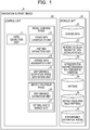
- FIG. 1 is a functional block diagram illustrating a configuration of a navigation support device according to an embodiment.
- the navigation support device 1 classifies vessel navigation data according to each meteorological and hydrographic condition, and calculates the distribution of vessel speed for each meteorological and hydrographic condition used for the classification.
- the navigation support device 1 aggregates the vessel voyage data for each vessel maneuvering pattern extracted from vessel maneuvering distribution calculated for each meteorological and hydrographic condition used for the classification.
- the navigation support device 1 learns the vessel performance using the aggregated vessel voyage data and past meteorological and hydrographic data for each vessel maneuvering pattern, and constructs an estimation model for the vessel performance for each vessel maneuvering pattern.
- the vessel performance mentioned here includes the navigation speed, fuel consumption amount, and the like of the vessel.
- the vessel maneuvering pattern mentioned here refers to a pattern that the captain actually selects when maneuvering the vessel.
- the vessel maneuvering pattern for example, "pattern a" in which the vessel is maneuvered at a normal output, “pattern b” in which the vessel is maneuvered with the engine output slightly lowered, “pattern c” in which the vessel is maneuvered on a voyage in deceleration, and the like are assumed.
- pattern a in which the vessel is maneuvered at a normal output
- pattern b in which the vessel is maneuvered with the engine output slightly lowered
- pattern c in which the vessel is maneuvered on a voyage in deceleration
- “Pattern a” is a pattern in which a vessel is maneuvered by selecting a route with low wind and wave resistance at a normal output prescribed at the time of designing the vessel.
- Normal output refers to an economical output from the viewpoint of engine efficiency and maintenance. A route selected at the normal output is deemed as a route that requires less fuel expense and takes less time.
- the pattern a is referred to as a vessel maneuvering pattern at the normal output.
- “Pattern b” is a pattern in which a vessel is maneuvered by lowering the output so as not to impose a load on the engine (not to cause a torque-rich phenomenon) under stormy weather.
- the pattern b is referred to as a vessel maneuvering pattern at a medium output.
- “Pattern c” is a pattern in which a vessel is decelerated and maneuvered in order to reduce fuel expense when there is no next navigation schedule and there is time to spare.
- the pattern c is referred to as a vessel maneuvering pattern at a small output. Note that the vessel maneuvering patterns are not limited to these patterns.
- the vessel maneuvering patterns may include a pattern d in which a vessel is maneuvered by increasing the output so as to impose a load on the engine when there is no time to spare.
- the pattern d is referred to as a vessel maneuvering pattern at a high output.
- FIG. 2 is a diagram illustrating an outline of navigation support according to the embodiment.
- the navigation support device 1 calculates the distribution of vessel speed from voyage data 21 relating to the vessel, and extracts a vessel maneuvering pattern (pattern) from the distribution of vessel speed ( ⁇ 1>).
- the distribution of vessel speed indicates the frequency distribution of vessel speed.
- the pattern is extracted based on the frequency of occurrence.
- a section with the highest frequency of occurrence is extracted as the pattern a at the normal output. This is because the captain often selects a route with low wind and wave resistance to navigate at the normal output prescribed at the time of designing the vessel.
- a section with the next highest frequency of occurrence is extracted as the pattern b at the medium output.
- a section with the slowest vessel speed is extracted as the pattern c at the small output.
- the distribution may be derived from engine speed or horsepower instead of vessel speed.
- the navigation support device 1 obtains voyage data 21' by aggregation for each pattern ( ⁇ 2>).
- the navigation support device 1 learns the vessel performance using the voyage data 21' aggregated for each pattern and actual meteorological/hydrographic data (actual/forecast) 22, and constructs an estimation model for the vessel performance for each pattern ( ⁇ 3>). This allows the navigation support device 1 to estimate the optimal route that suits the captain's sense by learning the vessel maneuvering actually performed by the captain.
- the navigation support device 1 includes a control unit 10 and a storage unit 20.
- the control unit 10 corresponds to an electronic circuit such as a central processing unit (CPU). Then, the control unit 10 includes an internal memory for storing programs defining various processing procedures and control data, and executes a variety of types of processing using the programs and the control data.
- the control unit 10 includes a data collection unit 11, a voyage data classification unit 12, a pattern extraction unit 13, a voyage data aggregation unit 14, a performance estimation model generation unit 15, a performance estimation unit 16, and an optimal route search unit 17.
- the voyage data classification unit 12, the pattern extraction unit 13, the voyage data aggregation unit 14, and the performance estimation model generation unit 15 are functional units for a model learning phase.
- the performance estimation unit 16 and the optimal route search unit 17 are functional units for a service provision phase.
- the voyage data classification unit 12 is an example of a classification unit.
- the pattern extraction unit 13 is an example of an extraction unit.
- the voyage data aggregation unit 14 is an example of a calculation unit and an aggregation unit.
- the performance estimation model generation unit is an example of a generation unit.
- the storage unit 20 is a semiconductor memory element such as a random access memory (RAM) or a flash memory, or a storage device such as a hard disk or an optical disc.
- the storage unit 20 has the voyage data 21, the meteorological/hydrographic data (actual/forecast) 22, voyage data (for each meteorological and hydrographic condition) 23, a pattern 24, voyage data (for each pattern) 25, and a performance estimation model 26.
- the voyage data 21 is data indicating, for example, when, where, at what speed, and in which direction the vessel was heading during voyage.
- the voyage data 21 is data indicating the history of vessel maneuvering performed by the captain of the vessel.
- the voyage data 21 is collected using an automatic identification system (AIS), a voyage data recorder (VDR), an engine logger, and the like.
- AIS automatic identification system
- VDR voyage data recorder
- engine logger an engine logger
- FIG. 3 is a diagram illustrating an example of the voyage data according to the embodiment.
- the voyage data 21 stores the latitude, longitude, speed, traveling direction,..., bow direction, time,..., for each versel_name in association with each other.
- the item versel_name indicates the name of the vessel.
- the voyage data 21 is not limited to this example, and the engine speed and consumed fuel may be further added.
- the meteorological/hydrographic data (actual/forecast) 22 includes meteorological data and hydrographic data including the actual results and forecasts for the vessel.
- the meteorological/hydrographic data (actual/forecast) 22 can be collected using, for example, data delivered from a weather forecast data provider.
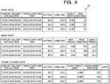
- FIG. 4 is a diagram illustrating an example of meteorological/hydrographic data according to the embodiment.
- the upper figure in FIG. 4 represents forecast wind data in the meteorological data.
- the middle figure in FIG. 4 represents forecast wave data in the hydrographic data.
- the lower figure in FIG. 4 represents forecast ocean current data in the hydrographic data.
- the wind data stores the latitude, longitude, wind speed, and wind direction in association with the forecast delivery date and time and the target date and time.
- the wave data stores the latitude, longitude, wave height, wave direction, and wave period in association with the forecast delivery date and time and the target date and time.
- the ocean current data stores the latitude, longitude, ocean current speed, ocean current direction, and layer in association with the forecast delivery date and time and the target date and time.
- the voyage data (for each meteorological and hydrographic condition) 23 is voyage data obtained by classifying the voyage data 21 according to each meteorological and hydrographic condition. Note that the voyage data (for each meteorological and hydrographic condition) 23 is classified by the voyage data classification unit 12.
- the pattern 24 is a vessel maneuvering pattern extracted from a plurality of vessel maneuvering patterns. Note that the pattern 24 is extracted by the pattern extraction unit 12.
- the voyage data (for each pattern) 25 is voyage data obtained by aggregating the voyage data 21 for each pattern. Note that the voyage data (for each pattern) 25 is aggregated by the voyage data aggregation unit 14.
- the performance estimation model 26 is an estimation model for the vessel performance for each pattern. Note that the performance estimation model 26 is generated by the performance estimation model generation unit 15.
- the data collection unit 11 collects various types of data. For example, the data collection unit 11 collects the voyage data 21 using an AIS. The data collection unit 11 receives the meteorological data (actual/forecast) and the hydrographic data (actual/forecast) delivered from the weather forecast data provider, and collects the meteorological/hydrographic data (actual/forecast) 22.
- the voyage data classification unit 12 classifies the voyage data 21 according to each meteorological and hydrographic condition.
- FIG. 5 is a diagram illustrating an example of voyage data classification processing according to the embodiment.
- the voyage data classification unit 12 classifies the voyage data 21 according to each meteorological and hydrographic condition assigned in advance, and generates the voyage data 23 for each meteorological and hydrographic condition.
- the case indicated here is a case where the wind speed and the wind direction are applied as meteorological and hydrographic conditions.
- meteorological and hydrographic conditions a case where the wind force is "0", a case where the wind force is "1" and forward, a case where the wind force is "1" and backward,..., and a case where the wind force is "10" and backward on the port side are illustrated.
- the voyage data 21 is classified according to each of such meteorological and hydrographic conditions into the voyage data 23 for each meteorological and hydrographic condition.
- the pattern extraction unit 13 clusters vessel speed data of the voyage data 23 for each meteorological and hydrographic condition, and extracts the vessel maneuvering pattern (pattern). For example, the pattern extraction unit 13 clusters the vessel speed data using data including at least the position (latitude and longitude), time, and vessel speed during voyage in the voyage data 23 for each meteorological and hydrographic condition. For clustering, the k-means method or the like can be used as an example. Then, as a result of clustering, the pattern extraction unit 13 extracts, as an example, a vessel maneuvering pattern (pattern a) at the normal output, a vessel maneuvering pattern (pattern b) at the medium output, a vessel maneuvering pattern (pattern c) at the small output, and the like.
- the pattern extraction unit 13 saves the extracted patterns in the pattern 24.
- the pattern extraction unit 13 has been described to cluster the vessel speed data of the voyage data 23 for each meteorological and hydrographic condition to extract patterns, but is not limited to this example.
- the engine speed or horsepower may be used instead of the vessel speed data to perform clustering and extract patterns.
- the voyage data aggregation unit 14 calculates the distribution of vessel speed using the voyage data 23 for each meteorological and hydrographic condition.
- the distribution of vessel speed mentioned here refers to, for example, the distribution of frequency of occurrence of vessel speed.
- the voyage data aggregation unit 14 calculates the distribution of frequency of occurrence of vessel speed with respect to the voyage data 23 for each meteorological and hydrographic condition.
- the voyage data aggregation unit 14 divides the distribution into sections based on the frequency of occurrence in the distribution of vessel speed calculated for each meteorological and hydrographic condition.
- the divided sections are associated with the vessel maneuvering patterns. This allows the voyage data aggregation unit 14 to regard a section of vessel speed with the highest frequency of occurrence as the vessel maneuvering pattern at the normal output, by calculating the frequency of occurrence of vessel speed under the same meteorological and hydrographic condition. In other words, this is because it is assumed that the captain often selects the normal output, which is an economical output, when maneuvering a vessel.
- the voyage data aggregation unit 14 can regard a section of the distribution obtained from the frequency of occurrence and the vessel speed, as a predetermined vessel maneuvering pattern, by calculating the frequency of occurrence of vessel speed under the same meteorological and hydrographic condition.
- the voyage data aggregation unit 14 aggregates the voyage data 23 for each meteorological and hydrographic condition for each vessel maneuvering pattern, and generates the voyage data 25 for each vessel maneuvering pattern.
- the voyage data aggregation unit 14 may correct the voyage data 25 for each vessel maneuvering pattern when obtaining the voyage data 25 for each vessel maneuvering pattern by aggregation.
- the voyage data aggregation unit 14 designates the vessel maneuvering pattern based on the frequency of occurrence of vessel speed for the same meteorological and hydrographic condition.
- the voyage data aggregation unit 14 designates the vessel maneuvering pattern only according to the vessel speed, aggregation will result in the vessel maneuvering pattern to be switched in a very short period of time, but in reality, the vessel maneuvering pattern is not switched in a very short period of time.
- the voyage data aggregation unit 14 to correct the voyage data of the vessel maneuvering pattern by employing a most frequent vessel maneuvering pattern contained in a predetermined period of time as a vessel maneuvering pattern for that period of time.
- FIG. 6 is a diagram illustrating an example of voyage data aggregation processing according to the embodiment.
- FIG. 6 describes a case where the voyage data aggregation unit 14 aggregates the voyage data 23 for each meteorological and hydrographic condition with respect to the vessel maneuvering pattern at the normal output, and generates the voyage data 25 of the vessel maneuvering pattern at the normal output.
- the voyage data aggregation unit 14 calculates a frequency distribution table of each vessel speed, using the voyage data 23 for each meteorological and hydrographic condition.
- the voyage data aggregation unit 14 divides the distribution into sections based on the frequency of occurrence in the calculated frequency distribution table of vessel speed.
- a section of vessel speed with the highest frequency of occurrence is regarded as the vessel maneuvering pattern at the normal output. This is because it is assumed that the captain often selects the normal output, which is an economical output, when maneuvering a vessel.
- the voyage data aggregation unit 14 aggregates the voyage data 23 for each meteorological and hydrographic condition, and generates the voyage data 25 of the vessel maneuvering pattern at the normal output.
- a section of vessel speed with the highest frequency of occurrence is regarded as the vessel maneuvering pattern at the normal output. Accordingly, the voyage data aggregation unit 14 aggregates the voyage data of the section of vessel speed with the highest frequency of occurrence from the respective frequency distribution tables calculated for each meteorological and hydrographic condition, and generates the voyage data 25 of the vessel maneuvering pattern at the normal output.
- a section of vessel speed with the next highest frequency of occurrence may be employed as the vessel maneuvering pattern at the medium output.
- the voyage data aggregation unit 14 aggregates the voyage data of the section of the distribution of vessel speed with the next highest frequency of occurrence from the respective frequency distribution tables calculated for each meteorological and hydrographic condition, and generates the voyage data 25 of the vessel maneuvering pattern at the medium output.
- a section of the distribution with the slowest vessel speed may be employed as the vessel maneuvering pattern at the small output.
- the voyage data aggregation unit 14 aggregates the voyage data of the section of the distribution with the slowest vessel speed from the respective frequency distribution tables calculated for each meteorological and hydrographic condition, and generates the voyage data 25 of the vessel maneuvering pattern at the small output. Furthermore, a section of the distribution with the fastest vessel speed may be employed as the vessel maneuvering pattern at the high output. In such a case, the voyage data aggregation unit 14 aggregates the voyage data of the section of the distribution with the fastest vessel speed from the respective frequency distribution tables calculated for each meteorological and hydrographic condition, and generates the voyage data 25 of the vessel maneuvering pattern at the high output.
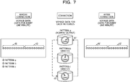
- FIG. 7 is a diagram illustrating an example of correction processing for the voyage data for each pattern according to the embodiment.
- the voyage data aggregation unit 14 has generated the voyage data 25 for each vessel maneuvering pattern, such as the pattern a (normal output), the pattern b, and the pattern c.
- the voyage data for every one minute before correction is represented.
- Each piece of the voyage data switches the vessel maneuvering pattern based on the frequency of occurrence of vessel speed.
- the voyage data aggregation unit 14 designates the vessel maneuvering pattern only according to the vessel speed, the vessel maneuvering pattern will be switched in a very short period of time, but in reality, the vessel maneuvering pattern is not switched in a very short period of time. Accordingly, when the duration time of a vessel maneuvering pattern is within a predetermined period of time, the voyage data aggregation unit 14 corrects the voyage data of the vessel maneuvering pattern by employing a most frequent vessel maneuvering pattern contained in a predetermined period of time as a vessel maneuvering pattern for that period of time.
- the respective pieces of voyage data are corrected as the voyage data of the most frequent pattern a, as indicated by the reference sign d1'.
- the voyage data aggregation unit 14 corrects the voyage data of the pattern c and the voyage data of the pattern b to the voyage data of the pattern a.
- the pattern c is the most frequent among respective pieces of voyage data denoted by the reference sign d2
- the respective pieces of voyage data are corrected as the voyage data of the most frequent pattern c, as indicated by the reference sign d2'.
- the voyage data aggregation unit 14 corrects the voyage data of the pattern a and the voyage data of the pattern b to the voyage data of the pattern c. This allows the voyage data aggregation unit 14 to aggregate the voyage data for each vessel maneuvering pattern in a realistic manner.
- the performance estimation model generation unit 15 learns the vessel performance using the aggregated voyage data 25 and the actual meteorological/hydrographic data 22 for each vessel maneuvering pattern, and generates an estimation model for the vessel performance. For example, the performance estimation model generation unit 15 generates the performance estimation model 26 for each vessel maneuvering pattern, using the actual meteorological/hydrographic data 22 as an explanatory variable and the vessel performance according to the voyage data 25 aggregated for each vessel maneuvering pattern as an objective variable. As an example, the performance estimation model generation unit 15 generates the performance estimation model 26 for each vessel maneuvering pattern by the least squares method with the multiple regression equation in following equation (1). Note that y in equation (1) is an objective variable, and indicates, for example, the vessel speed.
- Each of x 1 to x 6 in equation (1) is an explanatory variable, and indicates, for example, the wind speed, wind direction, wave height, wave direction, ocean current speed, and ocean current direction.
- y ⁇ 0 + ⁇ 1 x 1 + ⁇ 2 x 2 + ⁇ 3 x 3 + ⁇ 4 x 4 + ⁇ 4 x 4 + ⁇ 5 x 5 + ⁇ 6 x 6
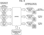
- FIG. 8 is a diagram illustrating an example of performance estimation model generation processing according to the embodiment.
- the performance estimation model generation unit 15 learns the vessel performance using the aggregated voyage data 25 and the actual meteorological/hydrographic data 22 for each vessel maneuvering pattern, and generates an estimation model for the vessel performance.
- the voyage data 25 for each of the pattern a, pattern b, and pattern c vessel maneuvering patterns has been aggregated.
- the performance estimation model generation unit 15 learns the vessel performance using, for example, "wind speed” in the actual meteorological/hydrographic data 22 as an explanatory variable and, for example, "vessel speed” in the voyage data 25 of the pattern a as an objective variable, and generates the performance estimation model 26 for the pattern a.
- the performance estimation model generation unit 15 learns the vessel performance using, for example, "wind speed” in the actual meteorological/hydrographic data 22 as an explanatory variable and, for example, "vessel speed” in the voyage data 25 of the pattern b as an objective variable, and generates the performance estimation model 26 for the pattern b.
- the performance estimation model generation unit 15 learns the vessel performance using, for example, "wind speed” in the actual meteorological/hydrographic data 22 as an explanatory variable and, for example, "vessel speed” in the voyage data 25 of the pattern c as an objective variable, and generates the performance estimation model 26 for the pattern c.
- FIG. 9 is a diagram illustrating an idea of the performance estimation model generation processing according to the embodiment. Note that FIG. 9 describes a case where a performance estimation model when the vessel maneuvering pattern is the pattern a at the normal output is to be generated. For convenience of explanation, only "wind speed" is employed as the explanatory variable.
- the performance estimation model generation unit 15 works out a regression line from two-dimensional coordinates when the x-axis denotes "wind speed” and the y-axis denotes "vessel speed".
- the performance estimation model generation unit 15 searches the voyage data 25 of the pattern a and the actual meteorological/hydrographic data 22 for "vessel speed" and "wind speed” at the same time and the same position (latitude and longitude), and samples "vessel speed” and "wind speed” found by the search in the two-dimensional coordinates. Then, the performance estimation model generation unit 15 works out a regression line by the least squares method with a plurality of the sampled points.
- the explanatory variable is not limited to this example.
- "vessel speed” is employed as the objective variable, but the objective variable is not limited to this example.
- “fuel consumption” may be employed as the objective variable.
- the performance estimation unit 16 estimates the vessel performance of the specified vessel maneuvering pattern from the forecast meteorological/hydrographic data 22 and the performance estimation model 26. For example, when accepting the specification of the vessel maneuvering pattern, the performance estimation unit 16 acquires the performance estimation model 26 corresponding to the vessel maneuvering pattern. The performance estimation unit 16 estimates the vessel performance at the target position (latitude and longitude) using the acquired performance estimation model 26 and the forecast meteorological/hydrographic data 22.
- the vessel performance mentioned here refers to the vessel speed and fuel consumption.
- the optimal route search unit 17 searches for an optimal route for the vessel based on the vessel performance estimated by the performance estimation unit 16.
- the optimal route search unit 17 accepts navigation conditions of a vessel.
- the navigation conditions of a vessel includes the departure place, arrival place, departure time, and vessel maneuvering pattern.
- the optimal route search unit 17 searches for an optimal route for a section from the departure place to the arrival place when departure is made at the specified departure time and the specified vessel maneuvering pattern is selected.
- the optimal route search unit 17 searches for the optimal route based on the estimated vessel performance at each position (latitude and longitude) included in the section. Any conventional technology may be used to search for the optimal route, as long as the estimated vessel performance is used.
- the optimal route search unit 17 saves the optimal route in the specified vessel maneuvering pattern in the storage unit 20 as the optimal route search result.
- the optimal route is a route that consumes less fuel and takes less time in operation in each selected vessel maneuvering pattern.
- the optimal route is a route that consumes less fuel and takes less time when making a voyage in the pattern a.
- the vessel maneuvering pattern is the pattern b at the medium output and a case where the vessel maneuvering pattern is the pattern c at the small output.
- FIG. 10 is a diagram illustrating an example of the performance estimation processing and the optimal route search processing according to the embodiment.
- the optimal route search unit 17 accepts the departure place, the arrival place, the departure time, and the vessel maneuvering pattern as navigation conditions for the vessel (S100).
- the optimal route search unit 17 makes an inquiry about the vessel performance (for example, the vessel speed) when the vessel is maneuvered in the accepted vessel maneuvering pattern for each position (latitude and longitude) included in the section from the departure place to the arrival place (S110).
- the performance estimation unit 16 When accepting the specification of the vessel maneuvering pattern and the target position, the performance estimation unit 16 acquires the performance estimation model 26 corresponding to the vessel maneuvering pattern. The performance estimation unit 16 estimates the vessel performance (for example, the vessel speed) at the target position (latitude and longitude) using the acquired performance estimation model 26 and the forecast meteorological/hydrographic data 22. Then, the performance estimation unit 16 feeds back with the estimated vessel performance (for example, the vessel speed) (S120). The performance estimation unit 16 repeatedly estimates the vessel performance for all the specified target positions, and feeds back with the estimated vessel performance.
- the vessel performance for example, the vessel speed
- the optimal route search unit 17 searches for an optimal route in the accepted vessel maneuvering pattern, based on the estimated vessel performance (for example, the vessel speed) at each position (latitude and longitude) included in the section (S130) .
- the optimal route for each vessel maneuvering pattern is represented.
- the optimal route whose vessel maneuvering pattern is the pattern a at the normal output is the route indicated by Optimal (normal).
- the optimal route whose vessel maneuvering pattern is the pattern b at the medium output is the route indicated by Optimal (slow x1).
- the optimal route whose vessel maneuvering pattern is the pattern c at the small output is the route indicated by Optimal (slow x2) .
- FIG. 11 is a diagram illustrating an example of the optimal route search result according to the embodiment.
- the upper figure in FIG. 11 illustrates summary data of the optimal route search result.
- the lower figure in FIG. 11 illustrates detailed data of the optimal route search result.
- FIG. 12 is a diagram illustrating an example of a flowchart of a model learning phase according to the embodiment.
- the voyage data classification unit 12 classifies the voyage data 21 (step S11), and generates the voyage data 23 for each meteorological and hydrographic condition.
- the pattern extraction unit 13 analyzes the pattern of vessel maneuvering from the voyage data 23 for each meteorological and hydrographic condition (step S12). As a result of the analysis, the voyage data aggregation unit 14 aggregates the voyage data 23 for each meteorological and hydrographic condition to obtain the voyage data by patterns of vessel maneuvering (step S13), and saves the voyage data 25 for each pattern. Then, the voyage data aggregation unit 14 corrects the voyage data aggregated by patterns of vessel maneuvering (step S14). Subsequently, the performance estimation model generation unit 15 generates the performance estimation model using the voyage data by patterns (the voyage data 25 for each pattern) (step S15) . Thereafter, the performance estimation model generation unit 15 saves the generated performance estimation model in the performance estimation model 26.
- FIG. 13 is a diagram illustrating a usage example of the navigation support processing according to the embodiment.
- the navigation support device 1 is connected through a network with a vessel on the sea (Sea) that uses the navigation support processing.
- the navigation support device 1 is connected through a network with a shipping company (Shipping company) on the shore (on shore).
- the navigation support device 1 is connected to various providers on the shore (on shore) through networks.
- Various providers include a provider of weather forecast data (Weather forecast data provider) and a provider of AIS data (AIS data provider).
- the navigation support device 1 collects actual and forecast meteorological and hydrographic data from the provider of weather forecast data.
- the navigation support device 1 collects voyage data from the provider of AIS data.
- the collected meteorological and hydrographic data and voyage data are reflected in the voyage data 21 and the meteorological/hydrographic data (actual/forecast) 22.
- the captain or on-shore staff inquires of the navigation support device 1 about the optimal route. Furthermore, the captain can also inquire of the navigation support device 1 about the optimal route during the navigation.
- the navigation support device 1 Upon accepting navigation conditions contained in the inquiry, the navigation support device 1 searches for an optimal route for the section from the departure place to the arrival place of the vessel when the departure is made at the departure time and the specified vessel maneuvering pattern is selected. Then, the navigation support device 1 responds to the inquiry source with the optimal route found by the search. Consequently, the navigation support device 1 can accurately recommend an optimal route according to a vessel maneuvering pattern.
- the navigation support device 1 classifies the voyage data 21 according to each meteorological and hydrographic condition.
- the navigation support device 1 calculates the characteristic distribution of vessel maneuvering for each meteorological and hydrographic condition using the classified voyage data 23.
- the navigation support device 1 extracts a plurality of vessel maneuvering patterns from the calculated characteristic distribution of vessel maneuvering for each meteorological and hydrographic condition, and aggregates the voyage data for each vessel maneuvering pattern.
- the navigation support device 1 generates a learning model for each vessel maneuvering pattern from the voyage data aggregated for each vessel maneuvering pattern, using meteorological and hydrographic actual data as the explanatory variable and the vessel performance as the objective variable.
- the navigation support device 1 can accurately recommend an optimal route according to the vessel maneuvering pattern, by using the learning model for the vessel performance for each vessel maneuvering pattern. For example, the navigation support device 1 is allowed to estimate the optimal route that suits the captain's sense by learning the vessel maneuvering actually performed by the captain.
- the navigation support device 1 divides the distribution into sections for each vessel maneuvering pattern based on the frequency of occurrence, and aggregates the voyage data of the sections of the distribution for each vessel maneuvering pattern. According to such a configuration, the navigation support device 1 can aggregate the voyage data according to the vessel maneuvering pattern. In particular, the navigation support device 1 can aggregate the voyage data at the normal output by regarding the voyage data of a section with the highest frequency of occurrence as the vessel maneuvering pattern at the normal output, which is often selected by the captain. As a result, the navigation support device 1 can search for an optimal route according to the vessel maneuvering pattern at the normal output.
- the navigation support device 1 estimates the vessel performance in a predetermined vessel maneuvering pattern, using the learning model for the predetermined vessel maneuvering pattern and meteorological and hydrographic prediction data. According to such a configuration, the navigation support device 1 can search for an optimal route for the vessel, based on the vessel performance in the predetermined vessel maneuvering pattern. For example, the navigation support device 1 can search for an optimal route that consumes less fuel and takes less time when the predetermined vessel maneuvering pattern is the pattern at the normal output.
- the navigation support device 1 aggregates the vessel voyage data of a section of the distribution with the maximum frequency of occurrence, as data of the vessel maneuvering pattern at the normal output. According to such a configuration, the navigation support device 1 can search for an optimal route according to the vessel maneuvering pattern at the normal output.
- each illustrated component of the navigation support device 1 is not necessarily physically configured as illustrated in the drawings.
- specific aspects of separation and integration of the navigation support device 1 are not limited to the illustrated ones, and all or a part of the device can be functionally or physically separated and integrated in an optional unit according to various loads, use states, or the like.
- the voyage data classification unit 12 and the pattern extraction unit 13 may be integrated as one unit.
- the voyage data aggregation unit 14 may be split into an aggregation unit that aggregates the voyage data 23 for each meteorological and hydrographic condition to generate the voyage data 25 for each vessel maneuvering pattern, and a correction unit that corrects the voyage data 25 for each vessel maneuvering pattern.
- the storage unit 20 may be connected by way of a network as an external device of the navigation support device 1.
- FIG. 14 is a diagram illustrating an example of a computer that executes the navigation support program.
- a computer 200 includes a CPU 203 that executes various types of arithmetic processing, an input device 215 that accepts data input from a user, and a display control unit 207 that controls a display device 209. Furthermore, the computer 200 also includes a drive device 213 that reads a program or the like from a storage medium, and a communication control unit 217 that exchanges data with another computer via a network. In addition, the computer 200 includes a memory 201 that temporarily stores various types of information, and a hard disk drive (HDD) 205. Then, the memory 201, the CPU 203, the HDD 205, the display control unit 207, the drive device 213, the input device 215, and the communication control unit 217 are connected by a bus 219.
- HDD hard disk drive
- the drive device 213 is a device for a removable disk 210, for example.
- the HDD 205 stores a navigation support program 205a and navigation support processing-related information 205b.
- the CPU 203 reads the navigation support program 205a, and loads the navigation support program 205a into the memory 201 to execute the navigation support program 205a as a process.
- Such a process corresponds to the respective functional units of the navigation support device 1.
- the navigation support processing-related information 205b corresponds to the voyage data 21, the meteorological/hydrographic data (actual/forecast) 22, the voyage data (for each meteorological and hydrographic condition) 23, the pattern 24, the voyage data (for each pattern) 25, and the performance estimation model 26.
- the removable disk 210 stores each piece of information such as the navigation support program 205a.
- the navigation support program 205a may not necessarily be stored in the HDD 205 from the beginning.
- the program is stored in a "portable physical medium" such as a flexible disk (FD), a compact disk read only memory (CD-ROM), a digital versatile disk (DVD), a magneto-optical disk, or an integrated circuit (IC) card, which is inserted into the computer 200.
- the computer 200 may read the navigation support program 205a from these media to execute the navigation support program 205a.
Landscapes
- Engineering & Computer Science (AREA)
- Radar, Positioning & Navigation (AREA)
- Remote Sensing (AREA)
- Physics & Mathematics (AREA)
- General Physics & Mathematics (AREA)
- Theoretical Computer Science (AREA)
- Data Mining & Analysis (AREA)
- Automation & Control Theory (AREA)
- General Engineering & Computer Science (AREA)
- Computer Vision & Pattern Recognition (AREA)
- Artificial Intelligence (AREA)
- Evolutionary Computation (AREA)
- Software Systems (AREA)
- Evolutionary Biology (AREA)
- Bioinformatics & Computational Biology (AREA)
- Life Sciences & Earth Sciences (AREA)
- Ocean & Marine Engineering (AREA)
- Bioinformatics & Cheminformatics (AREA)
- Medical Informatics (AREA)
- Computing Systems (AREA)
- Mathematical Physics (AREA)
- Navigation (AREA)
- Traffic Control Systems (AREA)
Abstract
Description
- The present invention relates to a navigation support method and the like.
- Navigation support technologies are disclosed.
- In one example, based on vessel voyage data and past meteorological and hydrographic data in a sea area where a vessel is to navigate, statistical values of a navigation speed required for the navigation and a fuel consumption amount due to the navigation are calculated in consideration of the influence of meteorological and hydrographic phenomena on the navigation when the vessel navigates in this sea area, and a time or a fuel consumption amount required for the navigation of the vessel is reasonably estimated using the statistical values (see, for example, Patent Document 1). The navigation speed and fuel consumption amount mentioned here refer to the performance of the vessel.
- Furthermore, in another example, statistical data obtained by statistically processing past meteorological and hydrographic data in an area including the departure place and a desired value of the route of the vessel is calculated, and an optimal route from the departure place to the desired value is computed based on the statistical data and navigation performance data of the vessel (see, for example, Patent Document 2).
- For example, in the navigation support technologies, the performance of a vessel is estimated based on vessel voyage data and past meteorological and hydrographic data, and an optimal route for this vessel is computed based on the estimated performance of the vessel and meteorological and hydrographic data.
-
- Patent Document 1:
Japanese Patent No. 6281022 - Patent Document 2:
Japanese Laid-open Patent Publication No. 2013-134089 - Incidentally, in the actual navigation, the captain of a vessel selects a route with low wind and wave resistance at a normal output prescribed at the time of designing the vessel. The normal output mentioned here is an output that is normally used to obtain navigation velocity, and refers to an economical output from the viewpoint of engine efficiency and maintenance. A route selected at the normal output is deemed as a route that requires less fuel expense and takes less time.
- However, the conventional navigation support technologies have a disadvantage that it is not possible to accurately recommend an optimal route at the normal output. For example, in the conventional navigation support technologies, the performance of the vessel is estimated using all the vessel voyage data including a voyage in deceleration in which a voyage is intentionally made in deceleration other than the normal output, and the like, and it is thus difficult to accurately recommend an optimal route at the normal output, which is regularly selected by the captain.
- Furthermore, even when using only the vessel voyage data at the normal output is attempted, since vessel maneuvering by the captain varies in a complicated manner depending on the meteorological and hydrographic conditions, it is difficult to discriminate which part of the vessel voyage data corresponds to data at the normal output.
- Note that the above-mentioned problem is a problem that arises not only in the normal output but also in other vessel maneuvering patterns similarly, such as a medium output that does not impose a load on the engine and a small output for reducing the fuel expense.
- In one mode, an object of the present invention is to accurately recommend an optimal route according to a vessel maneuvering pattern.
- In one aspect, in a navigation support method, a computer executes processing including: classifying vessel voyage data according to each meteorological and hydrographic condition; calculating characteristic distribution of vessel maneuvering for each meteorological and hydrographic condition, using the vessel voyage data that has been classified; extracting a plurality of vessel maneuvering patterns from the characteristic distribution of vessel maneuvering that has been calculated for each meteorological and hydrographic condition, and aggregating the vessel voyage data for each of the vessel maneuvering patterns; and generating a learning model for each of the vessel maneuvering patterns from the vessel voyage data aggregated for each of the vessel maneuvering patterns, using meteorological and hydrographic actual data as an explanatory variable and vessel performance as an objective variable.
- According to one aspect of embodiment, an optimal route according to a vessel maneuvering pattern can be accurately recommended.
-
-
FIG. 1 is a functional block diagram illustrating a configuration of a navigation support device according to an embodiment. -
FIG. 2 is a diagram illustrating an outline of navigation support according to the embodiment. -
FIG. 3 is a diagram illustrating an example of voyage data according to the embodiment. -
FIG. 4 is a diagram illustrating an example of meteorological/hydrographic data according to the embodiment. -
FIG. 5 is a diagram illustrating an example of voyage data classification processing according to the embodiment. -
FIG. 6 is a diagram illustrating an example of voyage data aggregation processing according to the embodiment. -
FIG. 7 is a diagram illustrating an example of correction processing for voyage data for each pattern according to the embodiment. -
FIG. 8 is a diagram illustrating an example of performance estimation model generation processing according to the embodiment. -
FIG. 9 is a diagram illustrating an idea of the performance estimation model generation processing according to the embodiment. -
FIG. 10 is a diagram illustrating an example of performance estimation processing and optimal route search processing according to the embodiment. -
FIG. 11 is a diagram illustrating an example of an optimal route search result according to the embodiment. -
FIG. 12 is a diagram illustrating an example of a flowchart of a model learning phase according to the embodiment. -
FIG. 13 is a diagram illustrating a usage example of navigation support processing according to the embodiment. -
FIG. 14 is a diagram illustrating an example of a computer that executes a navigation support program. - Hereinafter, embodiments of a navigation support method, a navigation support device, and a navigation support method disclosed in the present application will be described in detail with reference to the drawings. Note that the present invention is not limited to the embodiments.
-
FIG. 1 is a functional block diagram illustrating a configuration of a navigation support device according to an embodiment. As illustrated inFIG. 1 , thenavigation support device 1 classifies vessel navigation data according to each meteorological and hydrographic condition, and calculates the distribution of vessel speed for each meteorological and hydrographic condition used for the classification. Thenavigation support device 1 aggregates the vessel voyage data for each vessel maneuvering pattern extracted from vessel maneuvering distribution calculated for each meteorological and hydrographic condition used for the classification. Thenavigation support device 1 learns the vessel performance using the aggregated vessel voyage data and past meteorological and hydrographic data for each vessel maneuvering pattern, and constructs an estimation model for the vessel performance for each vessel maneuvering pattern. - The vessel performance mentioned here includes the navigation speed, fuel consumption amount, and the like of the vessel.
- The vessel maneuvering pattern mentioned here refers to a pattern that the captain actually selects when maneuvering the vessel. As the vessel maneuvering pattern, for example, "pattern a" in which the vessel is maneuvered at a normal output, "pattern b" in which the vessel is maneuvered with the engine output slightly lowered, "pattern c" in which the vessel is maneuvered on a voyage in deceleration, and the like are assumed. Hereinafter, the vessel maneuvering pattern is sometimes simply referred to as "pattern".
- "Pattern a" is a pattern in which a vessel is maneuvered by selecting a route with low wind and wave resistance at a normal output prescribed at the time of designing the vessel. "Normal output" refers to an economical output from the viewpoint of engine efficiency and maintenance. A route selected at the normal output is deemed as a route that requires less fuel expense and takes less time. The pattern a is referred to as a vessel maneuvering pattern at the normal output.
- "Pattern b" is a pattern in which a vessel is maneuvered by lowering the output so as not to impose a load on the engine (not to cause a torque-rich phenomenon) under stormy weather. The pattern b is referred to as a vessel maneuvering pattern at a medium output. "Pattern c" is a pattern in which a vessel is decelerated and maneuvered in order to reduce fuel expense when there is no next navigation schedule and there is time to spare. The pattern c is referred to as a vessel maneuvering pattern at a small output. Note that the vessel maneuvering patterns are not limited to these patterns. As an example, the vessel maneuvering patterns may include a pattern d in which a vessel is maneuvered by increasing the output so as to impose a load on the engine when there is no time to spare. The pattern d is referred to as a vessel maneuvering pattern at a high output.
- Here, an outline of navigation support according to the embodiment will be described with reference to
FIG. 2. FIG. 2 is a diagram illustrating an outline of navigation support according to the embodiment. - As illustrated in
FIG. 2 , thenavigation support device 1 calculates the distribution of vessel speed fromvoyage data 21 relating to the vessel, and extracts a vessel maneuvering pattern (pattern) from the distribution of vessel speed (<1>). The distribution of vessel speed indicates the frequency distribution of vessel speed. Here, the pattern is extracted based on the frequency of occurrence. A section with the highest frequency of occurrence is extracted as the pattern a at the normal output. This is because the captain often selects a route with low wind and wave resistance to navigate at the normal output prescribed at the time of designing the vessel. A section with the next highest frequency of occurrence is extracted as the pattern b at the medium output. A section with the slowest vessel speed is extracted as the pattern c at the small output. Note that the distribution may be derived from engine speed or horsepower instead of vessel speed. - Then, the
navigation support device 1 obtains voyage data 21' by aggregation for each pattern (<2>). - Subsequently, the
navigation support device 1 learns the vessel performance using the voyage data 21' aggregated for each pattern and actual meteorological/hydrographic data (actual/forecast) 22, and constructs an estimation model for the vessel performance for each pattern (<3>). This allows thenavigation support device 1 to estimate the optimal route that suits the captain's sense by learning the vessel maneuvering actually performed by the captain. - Returning to
FIG. 1 , thenavigation support device 1 includes acontrol unit 10 and astorage unit 20. - The
control unit 10 corresponds to an electronic circuit such as a central processing unit (CPU). Then, thecontrol unit 10 includes an internal memory for storing programs defining various processing procedures and control data, and executes a variety of types of processing using the programs and the control data. Thecontrol unit 10 includes adata collection unit 11, a voyagedata classification unit 12, apattern extraction unit 13, a voyagedata aggregation unit 14, a performance estimationmodel generation unit 15, aperformance estimation unit 16, and an optimalroute search unit 17. Note that the voyagedata classification unit 12, thepattern extraction unit 13, the voyagedata aggregation unit 14, and the performance estimationmodel generation unit 15 are functional units for a model learning phase. Furthermore, theperformance estimation unit 16 and the optimalroute search unit 17 are functional units for a service provision phase. In addition, the voyagedata classification unit 12 is an example of a classification unit. Thepattern extraction unit 13 is an example of an extraction unit. The voyagedata aggregation unit 14 is an example of a calculation unit and an aggregation unit. The performance estimation model generation unit is an example of a generation unit. - For example, the
storage unit 20 is a semiconductor memory element such as a random access memory (RAM) or a flash memory, or a storage device such as a hard disk or an optical disc. Thestorage unit 20 has thevoyage data 21, the meteorological/hydrographic data (actual/forecast) 22, voyage data (for each meteorological and hydrographic condition) 23, apattern 24, voyage data (for each pattern) 25, and aperformance estimation model 26. - The
voyage data 21 is data indicating, for example, when, where, at what speed, and in which direction the vessel was heading during voyage. In different terms, thevoyage data 21 is data indicating the history of vessel maneuvering performed by the captain of the vessel. For example, thevoyage data 21 is collected using an automatic identification system (AIS), a voyage data recorder (VDR), an engine logger, and the like. - Here, an example of the
voyage data 21 will be described with reference toFIG. 3. FIG. 3 is a diagram illustrating an example of the voyage data according to the embodiment. As illustrated inFIG. 3 , thevoyage data 21 stores the latitude, longitude, speed, traveling direction,..., bow direction, time,..., for each versel_name in association with each other. The item versel_name indicates the name of the vessel. Note that thevoyage data 21 is not limited to this example, and the engine speed and consumed fuel may be further added. - Returning to
FIG. 1 , the meteorological/hydrographic data (actual/forecast) 22 includes meteorological data and hydrographic data including the actual results and forecasts for the vessel. The meteorological/hydrographic data (actual/forecast) 22 can be collected using, for example, data delivered from a weather forecast data provider. - Here, an example of meteorological/hydrographic data (actual/forecast) 22 will be described with reference to
FIG. 4. FIG. 4 is a diagram illustrating an example of meteorological/hydrographic data according to the embodiment. The upper figure inFIG. 4 represents forecast wind data in the meteorological data. The middle figure inFIG. 4 represents forecast wave data in the hydrographic data. The lower figure inFIG. 4 represents forecast ocean current data in the hydrographic data. - As illustrated in the upper figure in
FIG. 4 , the wind data stores the latitude, longitude, wind speed, and wind direction in association with the forecast delivery date and time and the target date and time. As illustrated in the middle figure inFIG. 4 , the wave data stores the latitude, longitude, wave height, wave direction, and wave period in association with the forecast delivery date and time and the target date and time. As illustrated in the lower figure inFIG. 4 , the ocean current data stores the latitude, longitude, ocean current speed, ocean current direction, and layer in association with the forecast delivery date and time and the target date and time. - Returning to
FIG. 1 , the voyage data (for each meteorological and hydrographic condition) 23 is voyage data obtained by classifying thevoyage data 21 according to each meteorological and hydrographic condition. Note that the voyage data (for each meteorological and hydrographic condition) 23 is classified by the voyagedata classification unit 12. - The
pattern 24 is a vessel maneuvering pattern extracted from a plurality of vessel maneuvering patterns. Note that thepattern 24 is extracted by thepattern extraction unit 12. - The voyage data (for each pattern) 25 is voyage data obtained by aggregating the
voyage data 21 for each pattern. Note that the voyage data (for each pattern) 25 is aggregated by the voyagedata aggregation unit 14. - The
performance estimation model 26 is an estimation model for the vessel performance for each pattern. Note that theperformance estimation model 26 is generated by the performance estimationmodel generation unit 15. - The
data collection unit 11 collects various types of data. For example, thedata collection unit 11 collects thevoyage data 21 using an AIS. Thedata collection unit 11 receives the meteorological data (actual/forecast) and the hydrographic data (actual/forecast) delivered from the weather forecast data provider, and collects the meteorological/hydrographic data (actual/forecast) 22. - The voyage
data classification unit 12 classifies thevoyage data 21 according to each meteorological and hydrographic condition. - Here, an example of voyage data classification will be described with reference to
FIG. 5. FIG. 5 is a diagram illustrating an example of voyage data classification processing according to the embodiment. As illustrated inFIG. 5 , the voyagedata classification unit 12 classifies thevoyage data 21 according to each meteorological and hydrographic condition assigned in advance, and generates thevoyage data 23 for each meteorological and hydrographic condition. The case indicated here is a case where the wind speed and the wind direction are applied as meteorological and hydrographic conditions. As an example of meteorological and hydrographic conditions, a case where the wind force is "0", a case where the wind force is "1" and forward, a case where the wind force is "1" and backward,..., and a case where the wind force is "10" and backward on the port side are illustrated. Thevoyage data 21 is classified according to each of such meteorological and hydrographic conditions into thevoyage data 23 for each meteorological and hydrographic condition. - The
pattern extraction unit 13 clusters vessel speed data of thevoyage data 23 for each meteorological and hydrographic condition, and extracts the vessel maneuvering pattern (pattern). For example, thepattern extraction unit 13 clusters the vessel speed data using data including at least the position (latitude and longitude), time, and vessel speed during voyage in thevoyage data 23 for each meteorological and hydrographic condition. For clustering, the k-means method or the like can be used as an example. Then, as a result of clustering, thepattern extraction unit 13 extracts, as an example, a vessel maneuvering pattern (pattern a) at the normal output, a vessel maneuvering pattern (pattern b) at the medium output, a vessel maneuvering pattern (pattern c) at the small output, and the like. Subsequently, thepattern extraction unit 13 saves the extracted patterns in thepattern 24. Note that thepattern extraction unit 13 has been described to cluster the vessel speed data of thevoyage data 23 for each meteorological and hydrographic condition to extract patterns, but is not limited to this example. The engine speed or horsepower may be used instead of the vessel speed data to perform clustering and extract patterns. - Returning to
FIG. 1 , the voyagedata aggregation unit 14 calculates the distribution of vessel speed using thevoyage data 23 for each meteorological and hydrographic condition. The distribution of vessel speed mentioned here refers to, for example, the distribution of frequency of occurrence of vessel speed. For example, the voyagedata aggregation unit 14 calculates the distribution of frequency of occurrence of vessel speed with respect to thevoyage data 23 for each meteorological and hydrographic condition. - Furthermore, the voyage
data aggregation unit 14 divides the distribution into sections based on the frequency of occurrence in the distribution of vessel speed calculated for each meteorological and hydrographic condition. The divided sections are associated with the vessel maneuvering patterns. This allows the voyagedata aggregation unit 14 to regard a section of vessel speed with the highest frequency of occurrence as the vessel maneuvering pattern at the normal output, by calculating the frequency of occurrence of vessel speed under the same meteorological and hydrographic condition. In other words, this is because it is assumed that the captain often selects the normal output, which is an economical output, when maneuvering a vessel. Similarly, the voyagedata aggregation unit 14 can regard a section of the distribution obtained from the frequency of occurrence and the vessel speed, as a predetermined vessel maneuvering pattern, by calculating the frequency of occurrence of vessel speed under the same meteorological and hydrographic condition. - Furthermore, the voyage
data aggregation unit 14 aggregates thevoyage data 23 for each meteorological and hydrographic condition for each vessel maneuvering pattern, and generates thevoyage data 25 for each vessel maneuvering pattern. - Note that the voyage
data aggregation unit 14 may correct thevoyage data 25 for each vessel maneuvering pattern when obtaining thevoyage data 25 for each vessel maneuvering pattern by aggregation. For example, the voyagedata aggregation unit 14 designates the vessel maneuvering pattern based on the frequency of occurrence of vessel speed for the same meteorological and hydrographic condition. However, if the voyagedata aggregation unit 14 designates the vessel maneuvering pattern only according to the vessel speed, aggregation will result in the vessel maneuvering pattern to be switched in a very short period of time, but in reality, the vessel maneuvering pattern is not switched in a very short period of time. Accordingly, when the duration period of a vessel maneuvering pattern is within a predetermined period of time, it is desirable for the voyagedata aggregation unit 14 to correct the voyage data of the vessel maneuvering pattern by employing a most frequent vessel maneuvering pattern contained in a predetermined period of time as a vessel maneuvering pattern for that period of time. - Here, an example of voyage data aggregation will be described with reference to
FIG. 6. FIG. 6 is a diagram illustrating an example of voyage data aggregation processing according to the embodiment.FIG. 6 describes a case where the voyagedata aggregation unit 14 aggregates thevoyage data 23 for each meteorological and hydrographic condition with respect to the vessel maneuvering pattern at the normal output, and generates thevoyage data 25 of the vessel maneuvering pattern at the normal output. - The voyage
data aggregation unit 14 calculates a frequency distribution table of each vessel speed, using thevoyage data 23 for each meteorological and hydrographic condition. - Then, the voyage
data aggregation unit 14 divides the distribution into sections based on the frequency of occurrence in the calculated frequency distribution table of vessel speed. Here, a section of vessel speed with the highest frequency of occurrence is regarded as the vessel maneuvering pattern at the normal output. This is because it is assumed that the captain often selects the normal output, which is an economical output, when maneuvering a vessel. - Then, the voyage
data aggregation unit 14 aggregates thevoyage data 23 for each meteorological and hydrographic condition, and generates thevoyage data 25 of the vessel maneuvering pattern at the normal output. Here, a section of vessel speed with the highest frequency of occurrence is regarded as the vessel maneuvering pattern at the normal output. Accordingly, the voyagedata aggregation unit 14 aggregates the voyage data of the section of vessel speed with the highest frequency of occurrence from the respective frequency distribution tables calculated for each meteorological and hydrographic condition, and generates thevoyage data 25 of the vessel maneuvering pattern at the normal output. - Note that a section of vessel speed with the next highest frequency of occurrence may be employed as the vessel maneuvering pattern at the medium output. In such a case, the voyage
data aggregation unit 14 aggregates the voyage data of the section of the distribution of vessel speed with the next highest frequency of occurrence from the respective frequency distribution tables calculated for each meteorological and hydrographic condition, and generates thevoyage data 25 of the vessel maneuvering pattern at the medium output. Furthermore, a section of the distribution with the slowest vessel speed may be employed as the vessel maneuvering pattern at the small output. In such a case, the voyagedata aggregation unit 14 aggregates the voyage data of the section of the distribution with the slowest vessel speed from the respective frequency distribution tables calculated for each meteorological and hydrographic condition, and generates thevoyage data 25 of the vessel maneuvering pattern at the small output. Furthermore, a section of the distribution with the fastest vessel speed may be employed as the vessel maneuvering pattern at the high output. In such a case, the voyagedata aggregation unit 14 aggregates the voyage data of the section of the distribution with the fastest vessel speed from the respective frequency distribution tables calculated for each meteorological and hydrographic condition, and generates thevoyage data 25 of the vessel maneuvering pattern at the high output. -
FIG. 7 is a diagram illustrating an example of correction processing for the voyage data for each pattern according to the embodiment. InFIG. 7 , it is supposed that the voyagedata aggregation unit 14 has generated thevoyage data 25 for each vessel maneuvering pattern, such as the pattern a (normal output), the pattern b, and the pattern c. - As illustrated in
FIG. 7 , the voyage data for every one minute before correction is represented. Each piece of the voyage data switches the vessel maneuvering pattern based on the frequency of occurrence of vessel speed. However, if the voyagedata aggregation unit 14 designates the vessel maneuvering pattern only according to the vessel speed, the vessel maneuvering pattern will be switched in a very short period of time, but in reality, the vessel maneuvering pattern is not switched in a very short period of time. Accordingly, when the duration time of a vessel maneuvering pattern is within a predetermined period of time, the voyagedata aggregation unit 14 corrects the voyage data of the vessel maneuvering pattern by employing a most frequent vessel maneuvering pattern contained in a predetermined period of time as a vessel maneuvering pattern for that period of time. Here, since the pattern a is the most frequent among respective pieces of voyage data denoted by the reference sign d1, the respective pieces of voyage data are corrected as the voyage data of the most frequent pattern a, as indicated by the reference sign d1'. For example, the voyagedata aggregation unit 14 corrects the voyage data of the pattern c and the voyage data of the pattern b to the voyage data of the pattern a. Furthermore, since the pattern c is the most frequent among respective pieces of voyage data denoted by the reference sign d2, the respective pieces of voyage data are corrected as the voyage data of the most frequent pattern c, as indicated by the reference sign d2'. For example, the voyagedata aggregation unit 14 corrects the voyage data of the pattern a and the voyage data of the pattern b to the voyage data of the pattern c. This allows the voyagedata aggregation unit 14 to aggregate the voyage data for each vessel maneuvering pattern in a realistic manner. - Returning to
FIG. 1 , the performance estimationmodel generation unit 15 learns the vessel performance using the aggregatedvoyage data 25 and the actual meteorological/hydrographic data 22 for each vessel maneuvering pattern, and generates an estimation model for the vessel performance. For example, the performance estimationmodel generation unit 15 generates theperformance estimation model 26 for each vessel maneuvering pattern, using the actual meteorological/hydrographic data 22 as an explanatory variable and the vessel performance according to thevoyage data 25 aggregated for each vessel maneuvering pattern as an objective variable. As an example, the performance estimationmodel generation unit 15 generates theperformance estimation model 26 for each vessel maneuvering pattern by the least squares method with the multiple regression equation in following equation (1). Note that y in equation (1) is an objective variable, and indicates, for example, the vessel speed. Each of x1 to x6 in equation (1) is an explanatory variable, and indicates, for example, the wind speed, wind direction, wave height, wave direction, ocean current speed, and ocean current direction.
- Here, an example of performance estimation model generation according to the embodiment will be described with reference to
FIG. 8. FIG. 8 is a diagram illustrating an example of performance estimation model generation processing according to the embodiment. As illustrated inFIG. 8 , the performance estimationmodel generation unit 15 learns the vessel performance using the aggregatedvoyage data 25 and the actual meteorological/hydrographic data 22 for each vessel maneuvering pattern, and generates an estimation model for the vessel performance. Here, thevoyage data 25 for each of the pattern a, pattern b, and pattern c vessel maneuvering patterns has been aggregated. The performance estimationmodel generation unit 15 learns the vessel performance using, for example, "wind speed" in the actual meteorological/hydrographic data 22 as an explanatory variable and, for example, "vessel speed" in thevoyage data 25 of the pattern a as an objective variable, and generates theperformance estimation model 26 for the pattern a. The performance estimationmodel generation unit 15 learns the vessel performance using, for example, "wind speed" in the actual meteorological/hydrographic data 22 as an explanatory variable and, for example, "vessel speed" in thevoyage data 25 of the pattern b as an objective variable, and generates theperformance estimation model 26 for the pattern b. The performance estimationmodel generation unit 15 learns the vessel performance using, for example, "wind speed" in the actual meteorological/hydrographic data 22 as an explanatory variable and, for example, "vessel speed" in thevoyage data 25 of the pattern c as an objective variable, and generates theperformance estimation model 26 for the pattern c. - Here, an idea of the performance estimation model generation processing according to the embodiment will be described with reference to
FIG. 9. FIG. 9 is a diagram illustrating an idea of the performance estimation model generation processing according to the embodiment. Note thatFIG. 9 describes a case where a performance estimation model when the vessel maneuvering pattern is the pattern a at the normal output is to be generated. For convenience of explanation, only "wind speed" is employed as the explanatory variable. - As illustrated in
FIG. 9 , the performance estimationmodel generation unit 15 works out a regression line from two-dimensional coordinates when the x-axis denotes "wind speed" and the y-axis denotes "vessel speed". Here, the performance estimationmodel generation unit 15 searches thevoyage data 25 of the pattern a and the actual meteorological/hydrographic data 22 for "vessel speed" and "wind speed" at the same time and the same position (latitude and longitude), and samples "vessel speed" and "wind speed" found by the search in the two-dimensional coordinates. Then, the performance estimationmodel generation unit 15 works out a regression line by the least squares method with a plurality of the sampled points. - For example, the performance estimation
model generation unit 15 works out parameters β0 and β1 that minimize equation (2), and works out a regression line y = β0 + β1x1.
[Equation 1]
- Note that, in
FIG. 9 , for convenience of explanation, only "wind speed" is employed as the explanatory variable, but the explanatory variable is not limited to this example. For example, when "wind speed" and "wind direction" are employed as the explanatory variables, the performance estimationmodel generation unit 15 only needs to work out the regression line y = β0 + β1x1 + β2x2 from three-dimensional coordinates when the x-axis denotes "wind speed", the y-axis denotes "wind direction", and the z-axis denotes "vessel speed". Furthermore, inFIG. 9 , "vessel speed" is employed as the objective variable, but the objective variable is not limited to this example. For example, "fuel consumption" may be employed as the objective variable. - Returning to
FIG. 1 , theperformance estimation unit 16 estimates the vessel performance of the specified vessel maneuvering pattern from the forecast meteorological/hydrographic data 22 and theperformance estimation model 26. For example, when accepting the specification of the vessel maneuvering pattern, theperformance estimation unit 16 acquires theperformance estimation model 26 corresponding to the vessel maneuvering pattern. Theperformance estimation unit 16 estimates the vessel performance at the target position (latitude and longitude) using the acquiredperformance estimation model 26 and the forecast meteorological/hydrographic data 22. The vessel performance mentioned here refers to the vessel speed and fuel consumption. - The optimal
route search unit 17 searches for an optimal route for the vessel based on the vessel performance estimated by theperformance estimation unit 16. For example, the optimalroute search unit 17 accepts navigation conditions of a vessel. As an example, the navigation conditions of a vessel includes the departure place, arrival place, departure time, and vessel maneuvering pattern. The optimalroute search unit 17 searches for an optimal route for a section from the departure place to the arrival place when departure is made at the specified departure time and the specified vessel maneuvering pattern is selected. As an example, the optimalroute search unit 17 searches for the optimal route based on the estimated vessel performance at each position (latitude and longitude) included in the section. Any conventional technology may be used to search for the optimal route, as long as the estimated vessel performance is used. - Furthermore, the optimal
route search unit 17 saves the optimal route in the specified vessel maneuvering pattern in thestorage unit 20 as the optimal route search result. - Note that the optimal route is a route that consumes less fuel and takes less time in operation in each selected vessel maneuvering pattern. For example, when the vessel maneuvering pattern is the pattern a at the normal output, the optimal route is a route that consumes less fuel and takes less time when making a voyage in the pattern a. The same applies to a case where the vessel maneuvering pattern is the pattern b at the medium output and a case where the vessel maneuvering pattern is the pattern c at the small output.
- Here, an example of performance estimation processing and optimal route search processing according to the embodiment will be described with reference to
FIG. 10. FIG. 10 is a diagram illustrating an example of the performance estimation processing and the optimal route search processing according to the embodiment. - As illustrated in
FIG. 10 , the optimalroute search unit 17 accepts the departure place, the arrival place, the departure time, and the vessel maneuvering pattern as navigation conditions for the vessel (S100). The optimalroute search unit 17 makes an inquiry about the vessel performance (for example, the vessel speed) when the vessel is maneuvered in the accepted vessel maneuvering pattern for each position (latitude and longitude) included in the section from the departure place to the arrival place (S110). - When accepting the specification of the vessel maneuvering pattern and the target position, the
performance estimation unit 16 acquires theperformance estimation model 26 corresponding to the vessel maneuvering pattern. Theperformance estimation unit 16 estimates the vessel performance (for example, the vessel speed) at the target position (latitude and longitude) using the acquiredperformance estimation model 26 and the forecast meteorological/hydrographic data 22. Then, theperformance estimation unit 16 feeds back with the estimated vessel performance (for example, the vessel speed) (S120). Theperformance estimation unit 16 repeatedly estimates the vessel performance for all the specified target positions, and feeds back with the estimated vessel performance. - Subsequently, the optimal
route search unit 17 searches for an optimal route in the accepted vessel maneuvering pattern, based on the estimated vessel performance (for example, the vessel speed) at each position (latitude and longitude) included in the section (S130) . Here, the optimal route for each vessel maneuvering pattern is represented. The optimal route whose vessel maneuvering pattern is the pattern a at the normal output is the route indicated by Optimal (normal). The optimal route whose vessel maneuvering pattern is the pattern b at the medium output is the route indicated by Optimal (slow x1). The optimal route whose vessel maneuvering pattern is the pattern c at the small output is the route indicated by Optimal (slow x2) . -
FIG. 11 is a diagram illustrating an example of the optimal route search result according to the embodiment. The upper figure inFIG. 11 illustrates summary data of the optimal route search result. The lower figure inFIG. 11 illustrates detailed data of the optimal route search result. -
FIG. 12 is a diagram illustrating an example of a flowchart of a model learning phase according to the embodiment. - As illustrated in
FIG. 12 , the voyagedata classification unit 12 classifies the voyage data 21 (step S11), and generates thevoyage data 23 for each meteorological and hydrographic condition. - The
pattern extraction unit 13 analyzes the pattern of vessel maneuvering from thevoyage data 23 for each meteorological and hydrographic condition (step S12). As a result of the analysis, the voyagedata aggregation unit 14 aggregates thevoyage data 23 for each meteorological and hydrographic condition to obtain the voyage data by patterns of vessel maneuvering (step S13), and saves thevoyage data 25 for each pattern. Then, the voyagedata aggregation unit 14 corrects the voyage data aggregated by patterns of vessel maneuvering (step S14). Subsequently, the performance estimationmodel generation unit 15 generates the performance estimation model using the voyage data by patterns (thevoyage data 25 for each pattern) (step S15) . Thereafter, the performance estimationmodel generation unit 15 saves the generated performance estimation model in theperformance estimation model 26. -
FIG. 13 is a diagram illustrating a usage example of the navigation support processing according to the embodiment. As illustrated inFIG. 13 , thenavigation support device 1 is connected through a network with a vessel on the sea (Sea) that uses the navigation support processing. Thenavigation support device 1 is connected through a network with a shipping company (Shipping company) on the shore (on shore). Furthermore, thenavigation support device 1 is connected to various providers on the shore (on shore) through networks. Various providers include a provider of weather forecast data (Weather forecast data provider) and a provider of AIS data (AIS data provider). - The
navigation support device 1 collects actual and forecast meteorological and hydrographic data from the provider of weather forecast data. Thenavigation support device 1 collects voyage data from the provider of AIS data. The collected meteorological and hydrographic data and voyage data are reflected in thevoyage data 21 and the meteorological/hydrographic data (actual/forecast) 22. - Prior to the navigation, the captain or on-shore staff inquires of the
navigation support device 1 about the optimal route. Furthermore, the captain can also inquire of thenavigation support device 1 about the optimal route during the navigation. - Upon accepting navigation conditions contained in the inquiry, the
navigation support device 1 searches for an optimal route for the section from the departure place to the arrival place of the vessel when the departure is made at the departure time and the specified vessel maneuvering pattern is selected. Then, thenavigation support device 1 responds to the inquiry source with the optimal route found by the search. Consequently, thenavigation support device 1 can accurately recommend an optimal route according to a vessel maneuvering pattern. - According to the above embodiment, the
navigation support device 1 classifies thevoyage data 21 according to each meteorological and hydrographic condition. Thenavigation support device 1 calculates the characteristic distribution of vessel maneuvering for each meteorological and hydrographic condition using the classifiedvoyage data 23. Thenavigation support device 1 extracts a plurality of vessel maneuvering patterns from the calculated characteristic distribution of vessel maneuvering for each meteorological and hydrographic condition, and aggregates the voyage data for each vessel maneuvering pattern. Thenavigation support device 1 generates a learning model for each vessel maneuvering pattern from the voyage data aggregated for each vessel maneuvering pattern, using meteorological and hydrographic actual data as the explanatory variable and the vessel performance as the objective variable. According to such a configuration, thenavigation support device 1 can accurately recommend an optimal route according to the vessel maneuvering pattern, by using the learning model for the vessel performance for each vessel maneuvering pattern. For example, thenavigation support device 1 is allowed to estimate the optimal route that suits the captain's sense by learning the vessel maneuvering actually performed by the captain. - Furthermore, according to the above embodiment, for the characteristic distribution of vessel maneuvering calculated for each meteorological and hydrographic condition, the
navigation support device 1 divides the distribution into sections for each vessel maneuvering pattern based on the frequency of occurrence, and aggregates the voyage data of the sections of the distribution for each vessel maneuvering pattern. According to such a configuration, thenavigation support device 1 can aggregate the voyage data according to the vessel maneuvering pattern. In particular, thenavigation support device 1 can aggregate the voyage data at the normal output by regarding the voyage data of a section with the highest frequency of occurrence as the vessel maneuvering pattern at the normal output, which is often selected by the captain. As a result, thenavigation support device 1 can search for an optimal route according to the vessel maneuvering pattern at the normal output. - In addition, according to the above embodiment, the
navigation support device 1 estimates the vessel performance in a predetermined vessel maneuvering pattern, using the learning model for the predetermined vessel maneuvering pattern and meteorological and hydrographic prediction data. According to such a configuration, thenavigation support device 1 can search for an optimal route for the vessel, based on the vessel performance in the predetermined vessel maneuvering pattern. For example, thenavigation support device 1 can search for an optimal route that consumes less fuel and takes less time when the predetermined vessel maneuvering pattern is the pattern at the normal output. - Furthermore, according to the above embodiment, for the characteristic distribution of vessel maneuvering calculated for each meteorological and hydrographic condition, the
navigation support device 1 aggregates the vessel voyage data of a section of the distribution with the maximum frequency of occurrence, as data of the vessel maneuvering pattern at the normal output. According to such a configuration, thenavigation support device 1 can search for an optimal route according to the vessel maneuvering pattern at the normal output. - Note that each illustrated component of the
navigation support device 1 is not necessarily physically configured as illustrated in the drawings. For example, specific aspects of separation and integration of thenavigation support device 1 are not limited to the illustrated ones, and all or a part of the device can be functionally or physically separated and integrated in an optional unit according to various loads, use states, or the like. For example, the voyagedata classification unit 12 and thepattern extraction unit 13 may be integrated as one unit. Furthermore, the voyagedata aggregation unit 14 may be split into an aggregation unit that aggregates thevoyage data 23 for each meteorological and hydrographic condition to generate thevoyage data 25 for each vessel maneuvering pattern, and a correction unit that corrects thevoyage data 25 for each vessel maneuvering pattern. In addition, thestorage unit 20 may be connected by way of a network as an external device of thenavigation support device 1. - Furthermore, various types of processing described in the above embodiment can be achieved by a computer such as a personal computer or a work station executing programs prepared in advance. Thus, in the following, an example of a computer that executes a navigation support program that achieves functions similar to the functions of the
navigation support device 1 illustrated inFIG. 1 will be described.FIG. 14 is a diagram illustrating an example of a computer that executes the navigation support program. - As illustrated in
FIG. 14 , acomputer 200 includes aCPU 203 that executes various types of arithmetic processing, aninput device 215 that accepts data input from a user, and adisplay control unit 207 that controls adisplay device 209. Furthermore, thecomputer 200 also includes adrive device 213 that reads a program or the like from a storage medium, and acommunication control unit 217 that exchanges data with another computer via a network. In addition, thecomputer 200 includes amemory 201 that temporarily stores various types of information, and a hard disk drive (HDD) 205. Then, thememory 201, theCPU 203, theHDD 205, thedisplay control unit 207, thedrive device 213, theinput device 215, and thecommunication control unit 217 are connected by abus 219. - The
drive device 213 is a device for aremovable disk 210, for example. TheHDD 205 stores anavigation support program 205a and navigation support processing-relatedinformation 205b. - The
CPU 203 reads thenavigation support program 205a, and loads thenavigation support program 205a into thememory 201 to execute thenavigation support program 205a as a process. Such a process corresponds to the respective functional units of thenavigation support device 1. The navigation support processing-relatedinformation 205b corresponds to thevoyage data 21, the meteorological/hydrographic data (actual/forecast) 22, the voyage data (for each meteorological and hydrographic condition) 23, thepattern 24, the voyage data (for each pattern) 25, and theperformance estimation model 26. Then, for example, theremovable disk 210 stores each piece of information such as thenavigation support program 205a. - Note that the
navigation support program 205a may not necessarily be stored in theHDD 205 from the beginning. For example, the program is stored in a "portable physical medium" such as a flexible disk (FD), a compact disk read only memory (CD-ROM), a digital versatile disk (DVD), a magneto-optical disk, or an integrated circuit (IC) card, which is inserted into thecomputer 200. Then, thecomputer 200 may read thenavigation support program 205a from these media to execute thenavigation support program 205a. -
- 1 navigation support device
- 10 control unit
- 11 data collection unit
- 12 voyage data classification unit
- 13 pattern extraction unit
- 14 voyage data aggregation unit
- 15 performance estimation model generation unit
- 16 performance estimation unit
- 17 optimal route search unit
- 20 storage unit
- 21 voyage data
- 22 meteorological/hydrographic data (actual/forecast)
- 23 voyage data (for each meteorological and hydrographic condition)
- 24 pattern
- 25 voyage data (for each pattern)
- 26 performance estimation model
Claims (6)
- A navigation support method executed by a computer, the navigation support method comprising:classifying vessel voyage data according to each meteorological and hydrographic condition;calculating characteristic distribution of vessel maneuvering for each meteorological and hydrographic condition, using the vessel voyage data that has been classified;extracting a plurality of vessel maneuvering patterns from the characteristic distribution of vessel maneuvering that has been calculated for each meteorological and hydrographic condition, and aggregating the vessel voyage data for each of the vessel maneuvering patterns; andgenerating a learning model for each of the vessel maneuvering patterns from the vessel voyage data aggregated for each of the vessel maneuvering patterns, using meteorological and hydrographic actual data as an explanatory variable and vessel performance as an objective variable.
- The navigation support method according to claim 1, wherein
for performance characteristic distribution that indicates the characteristic distribution of vessel maneuvering calculated for each meteorological and hydrographic condition, the aggregating divides the distribution into sections for each of the vessel maneuvering patterns based on a frequency of occurrence, and aggregates the vessel voyage data of the sections of the distribution for each of the vessel maneuvering patterns. - The navigation support method according to claim 1, wherein
vessel performance in a predetermined vessel maneuvering pattern is estimated using the learning model for the predetermined vessel maneuvering pattern and meteorological and hydrographic prediction data. - The navigation support method according to claim 2, wherein
for the characteristic distribution of vessel maneuvering calculated for each meteorological and hydrographic condition, the aggregating aggregates the vessel voyage data of a section of the distribution with a maximum frequency of occurrence, as data of one of the vessel maneuvering patterns at a normal output. - A navigation support device comprising:a classification unit configured to classify vessel voyage data according to each meteorological and hydrographic condition;a calculation unit configured to calculate characteristic distribution of vessel maneuvering for each meteorological and hydrographic condition, using the vessel voyage data that has been classified;an extraction unit configured to extract a plurality of vessel maneuvering patterns from the characteristic distribution of vessel maneuvering that has been calculated for each meteorological and hydrographic condition;an aggregation unit configured to aggregate the vessel voyage data for each of the vessel maneuvering patterns; anda generation unit configured to generate a learning model for each of the vessel maneuvering patterns from the vessel voyage data aggregated for each of the vessel maneuvering patterns, using meteorological and hydrographic actual data as an explanatory variable and vessel performance as an objective variable.
- A navigation support program causing a computer to execute processing, the processing comprising:classifying vessel voyage data according to each meteorological and hydrographic condition;calculating characteristic distribution of vessel maneuvering for each meteorological and hydrographic condition, using the vessel voyage data that has been classified;extracting a plurality of vessel maneuvering patterns from the characteristic distribution of vessel maneuvering that has been calculated for each meteorological and hydrographic condition, and aggregating the vessel voyage data for each of the vessel maneuvering patterns; andgenerating a learning model for each of the vessel maneuvering patterns from the vessel voyage data aggregated for each of the vessel maneuvering patterns, using meteorological and hydrographic actual data as an explanatory variable and vessel performance as an objective variable.
Applications Claiming Priority (1)
| Application Number | Priority Date | Filing Date | Title |
|---|---|---|---|
| PCT/JP2018/047100 WO2020129225A1 (en) | 2018-12-20 | 2018-12-20 | Navigation assistance method, navigation assistance device, and navigation assistance program |
Publications (2)
| Publication Number | Publication Date |
|---|---|
| EP3901580A1 true EP3901580A1 (en) | 2021-10-27 |
| EP3901580A4 EP3901580A4 (en) | 2021-12-15 |
Family
ID=71100748
Family Applications (1)
| Application Number | Title | Priority Date | Filing Date |
|---|---|---|---|
| EP18943973.0A Withdrawn EP3901580A4 (en) | 2018-12-20 | 2018-12-20 | AID TO NAVIGATION PROCESS, AID TO NAVIGATION DEVICE AND AID TO NAVIGATION PROGRAM |
Country Status (4)
| Country | Link |
|---|---|
| US (1) | US20210285772A1 (en) |
| EP (1) | EP3901580A4 (en) |
| JP (1) | JP7226453B2 (en) |
| WO (1) | WO2020129225A1 (en) |
Cited By (1)
| Publication number | Priority date | Publication date | Assignee | Title |
|---|---|---|---|---|
| WO2025005872A1 (en) * | 2023-06-30 | 2025-01-02 | Pyxis Maritime Pte. Ltd. | A system and method for routing a vessel |
Families Citing this family (6)
| Publication number | Priority date | Publication date | Assignee | Title |
|---|---|---|---|---|
| JP7716876B2 (en) * | 2021-04-15 | 2025-08-01 | 川崎重工業株式会社 | Ship-steering support device, ship-steering support system, ship, ship-steering support method and program |
| JP7698972B2 (en) * | 2021-04-15 | 2025-06-26 | 川崎重工業株式会社 | Ship-steering support device, ship-steering support system, ship, ship-steering support method and program |
| KR102794932B1 (en) * | 2021-12-28 | 2025-04-15 | 주식회사 웨더아이 | Server, method and computer program for deriving optimized route information of vessel |
| JP7218973B1 (en) | 2022-07-20 | 2023-02-07 | 独立行政法人国立高等専門学校機構 | Operation support system |
| JP7768177B2 (en) * | 2023-03-30 | 2025-11-12 | 横河電機株式会社 | Apparatus, method and program |
| CN119293461B (en) * | 2024-12-12 | 2025-03-21 | 交通运输部水运科学研究所 | Integrated configuration verification method and system for site digital water level navigation data |
Family Cites Families (11)
| Publication number | Priority date | Publication date | Assignee | Title |
|---|---|---|---|---|
| JPS62274500A (en) * | 1986-05-23 | 1987-11-28 | 日本鋼管株式会社 | Collision/stranding detection system for ships |
| JP2001291200A (en) * | 2000-04-05 | 2001-10-19 | Mitsubishi Heavy Ind Ltd | Device for managing vessel plying |
| US7698024B2 (en) * | 2007-11-19 | 2010-04-13 | Integrated Power Technology Corporation | Supervisory control and data acquisition system for energy extracting vessel navigation |
| JP4970346B2 (en) * | 2008-05-28 | 2012-07-04 | 三井造船株式会社 | Ship operation support system and ship operation support method |
| JP5276720B2 (en) | 2009-11-04 | 2013-08-28 | 川崎重工業株式会社 | Ship maneuvering control method and ship maneuvering control system |
| JP4934756B1 (en) | 2011-11-10 | 2012-05-16 | 三井造船株式会社 | Ship optimum route calculation system, vessel operation support system, vessel optimum route calculation method, and vessel operation support method |
| JP2013134089A (en) | 2011-12-26 | 2013-07-08 | Mitsubishi Heavy Ind Ltd | Optimal sailing route calculating apparatus and optimal sailing route calculating method |
| EP2669173A1 (en) * | 2012-06-01 | 2013-12-04 | ABB Technology AG | Method and system for evaluation of ship performance |
| EP2669630A1 (en) * | 2012-06-01 | 2013-12-04 | ABB Technology AG | Method and system for determination of a route for a ship |
| WO2014188584A1 (en) * | 2013-05-24 | 2014-11-27 | 日本郵船株式会社 | Ship managing device, ship managing system, and program |
| JP6281022B1 (en) | 2016-10-12 | 2018-02-14 | 日本郵船株式会社 | Data processing apparatus, program, and recording medium for estimating time or fuel consumption required for navigation of ship |
-
2018
- 2018-12-20 JP JP2020561106A patent/JP7226453B2/en active Active
- 2018-12-20 WO PCT/JP2018/047100 patent/WO2020129225A1/en not_active Ceased
- 2018-12-20 EP EP18943973.0A patent/EP3901580A4/en not_active Withdrawn
-
2021
- 2021-06-02 US US17/336,884 patent/US20210285772A1/en not_active Abandoned
Cited By (1)
| Publication number | Priority date | Publication date | Assignee | Title |
|---|---|---|---|---|
| WO2025005872A1 (en) * | 2023-06-30 | 2025-01-02 | Pyxis Maritime Pte. Ltd. | A system and method for routing a vessel |
Also Published As
| Publication number | Publication date |
|---|---|
| JPWO2020129225A1 (en) | 2021-10-14 |
| EP3901580A4 (en) | 2021-12-15 |
| WO2020129225A1 (en) | 2020-06-25 |
| JP7226453B2 (en) | 2023-02-21 |
| US20210285772A1 (en) | 2021-09-16 |
Similar Documents
| Publication | Publication Date | Title |
|---|---|---|
| EP3901580A1 (en) | Navigation assistance method, navigation assistance device, and navigation assistance program | |
| KR101982582B1 (en) | System for evaluation of vessel based by automatic identification system data and marine environment data connected big data | |
| SE1251163A1 (en) | System and method in connection with the occurrence of vehicle trains | |
| CN109858372A (en) | A lane-level precision automated driving structured data analysis method | |
| JP5090955B2 (en) | Lightning prediction device, method and program thereof | |
| CN114936332B (en) | A method, device and storage medium for analyzing ship traffic flow in wind farm waters | |
| EP3798941A1 (en) | Vacant house determination device, vacant house determination method, and recording medium | |
| JP2009192311A (en) | Lightning prediction device, method and program thereof | |
| US20210293542A1 (en) | Navigation support method, navigation support device, and computer-readable recording medium recording navigation support program | |
| CN119479368A (en) | A method for analyzing maritime traffic flow based on big data | |
| CN109858951A (en) | Prediction of power-up or power-swap demand for new energy vehicles | |
| US9835458B2 (en) | Ship assignment device, ship assignment method, program, and recording medium | |
| CN120013003A (en) | Cross-domain big data fusion analysis and intelligent prediction system | |
| CN113720340A (en) | Method and device for determining geographic position, electronic equipment and storage medium | |
| CN117581078A (en) | Determine transport route maps and routes | |
| CN118656308B (en) | A method for extending data of expected functional safety test of Internet of Vehicles | |
| CN111681131B (en) | Water resource management method and management system based on artificial intelligence | |
| WO2018115569A1 (en) | Method for analyzing fleet operations | |
| Schwinger et al. | Combining profile similarity and Kalman filter for real-world applicable short-term bus travel time prediction | |
| WO2012089926A1 (en) | A method for determining statistical distribution of characteristic parameters of a vessel | |
| CN120176686B (en) | Intelligent navigation method and system based on surplus water depth management | |
| CN118587937B (en) | A method, device and equipment for route planning considering altitude | |
| CN119313248B (en) | Mail wheel transportation path optimization method and system based on artificial intelligence | |
| JP2004266927A (en) | Time series waveform prediction device, supply and demand adjustment system, power supply and demand adjustment system, time series waveform prediction method, computer program, and computer readable recording medium | |
| CN110874708B (en) | Method for detecting taxi shift time and computer-readable storage medium |
Legal Events
| Date | Code | Title | Description |
|---|---|---|---|
| STAA | Information on the status of an ep patent application or granted ep patent |
Free format text: STATUS: THE INTERNATIONAL PUBLICATION HAS BEEN MADE |
|
| PUAI | Public reference made under article 153(3) epc to a published international application that has entered the european phase |
Free format text: ORIGINAL CODE: 0009012 |
|
| STAA | Information on the status of an ep patent application or granted ep patent |
Free format text: STATUS: REQUEST FOR EXAMINATION WAS MADE |
|
| 17P | Request for examination filed |
Effective date: 20210602 |
|
| AK | Designated contracting states |
Kind code of ref document: A1 Designated state(s): AL AT BE BG CH CY CZ DE DK EE ES FI FR GB GR HR HU IE IS IT LI LT LU LV MC MK MT NL NO PL PT RO RS SE SI SK SM TR |
|
| A4 | Supplementary search report drawn up and despatched |
Effective date: 20211115 |
|
| RIC1 | Information provided on ipc code assigned before grant |
Ipc: B63B 79/20 20200101ALI20211109BHEP Ipc: B63B 71/00 20200101ALI20211109BHEP Ipc: B63H 21/21 20060101ALI20211109BHEP Ipc: B63H 25/04 20060101ALI20211109BHEP Ipc: G08G 3/00 20060101ALI20211109BHEP Ipc: G01C 21/20 20060101AFI20211109BHEP |
|
| DAV | Request for validation of the european patent (deleted) | ||
| DAX | Request for extension of the european patent (deleted) | ||
| STAA | Information on the status of an ep patent application or granted ep patent |
Free format text: STATUS: EXAMINATION IS IN PROGRESS |
|
| 17Q | First examination report despatched |
Effective date: 20230530 |
|
| STAA | Information on the status of an ep patent application or granted ep patent |
Free format text: STATUS: THE APPLICATION HAS BEEN WITHDRAWN |
|
| 18W | Application withdrawn |
Effective date: 20231102 |